Work Plan EAS Components
|
|
|
- Allyson Jacobs
- 6 years ago
- Views:
Transcription


1 October 27, 2010
2 Work Plan EAS Components Completed Tasks: Organization, Background Investigation and Comparison of Review Criteria (B1) Ecological Assessments and Database Compilation (B2) Data Evaluation (B3) Baseline condition of wetlands has been evaluated Evaluate Existing Environmental Monitoring Network (B4) Existing monitoring network has been identified
3 Work Plan EAS Components Work In Progress: Data Evaluation (B3) Comparison of simulated model results to observed field conditions Coordination with Modeling and Tools Subgroup to estimate groundwater availability Presentation of findings at public workshops
4 Work Plan EAS Components Work In Progress: Evaluate Existing Environmental Monitoring Network (B4) Identification of additional monitoring needs Environmental Assessment Report (B5) Development of a final report describing the methods and results of the environmental impact assessments (current and future)
5 Environmental Assessment Process Identification of evaluation sites Data collection (field data, aerials and other sources) Database compilation (Google/KML and ArcMap/GIS) Data evaluation (wetlands, lakes, and streams) Verification Additional data collection Compilation of preliminary results
6 Field Assessment Data Habitat condition Photo documentation Soils Vegetative community characteristics Community type(s) Zonation Plant species list and abundance Observed health
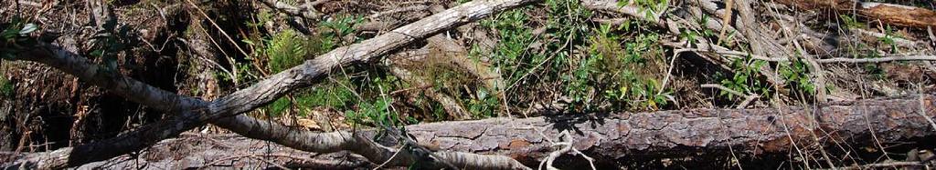
7 Field Assessment Data Hydrologic indicators Moss collars Lichen or stain lines Adventitious roots Tree buttressing Wetland edge characteristics Observed water levels Wetland SF CT, Orange County, Florida
8 Field Assessment Data Drainage alterations Ditches Canals Drainage wells Culverts Retention ponds Landscape context Other field data or indicators
9 Other Sources of Data Drainage well locations Natural and man made drainage feature maps County soil survey data USGS quad maps Landscape position maps (ridge, slope, valley) Historical aerial photography
10 Methods Separated sites into non confounded and confounded (e.g., ditches, canals, regulated lakes, RIBS) categories Separated each category into wetland, lake or stream subgroups Reviewed field data/photos and historical aerial photography Determined if hydrologic stress is present
11 Field Indicators of Stress Vegetation Invasion by plants of drier communities Leaning/fallen trees Dead trees or other vegetation Shifts and changes in plant communities Age class differences of trees Lack of regeneration of wetland plant species
12 Field Indicators of Stress Organic soils Oxidation/subsidence (exposed roots) Fissuring Hydrology Evidence of reduced hydrology Lack of hydrologic indicators


13 Abnormal Tree Fall Leaning Trees

14 Vegetation Shifts Mature Pine Edge New Pine Recruitment

15 Soil Fissures

 Soil")
16 Organic Soil Loss f ~Historic Soil Level Exposed roots (soil subsidence) Soil subsidence
17 Methods for Determining Stress Herbaceous Wetlands and Lakes Stress Indicators Organic soil fissuring Lack of hydrologic indicators Shifts or changes in plant communities Invasion of woody species Changes from historical condition Aerial Photography Time Series Analysis Change in spatial extent and wetland type Hydrologic change (drier condition) Wetland alterations (dredging, filling)
18 Methods for Determining Stress Forested Wetlands (includes all stream sites) Stress indicators Soil subsidence/exposed roots Invasion by plants of drier communities Shifts or changes in plant communities Leaning/fallen trees Soil fissuring Age class difference in trees Lack of regeneration Lack of hydrologic indicators Dead trees or other vegetation Aerial photography analysis Fallen trees Wetland alterations (dredging, filling, logging) Change in spatial extent and wetland type
19 Preliminary Results 397 Assessment sites 231 Wetlands 20 Streams 146 Lakes
20 Assessment Sites
21 Non Confounded Sites
22 Non Confounded/Stressed Sites

23 All Stressed Sites
24 Work In Progress 25 additional sites to be evaluated Finalize results and databases Identify additional monitoring needs Develop Environmental Assessment Report
25 Work In Progress Coordination with Modeling/Tools Team Evaluation of model runs Identification of groundwater availability Solutions evaluation
26 Questions
Agenda. CFWI Regulatory Team Meeting February 7, 2014 (9:00 to 12:00) West Osceola Branch Library and Field Trip*
 West Osceola Branch Library and Field Trip*") Agenda CFWI Regulatory Team Meeting February 7, 2014 (9:00 to 12:00) West Osceola Branch Library and Field Trip* 9:00 9:15 Meet at West Osceola Branch Library Multipurpose Room 305 Campus Street; Celebration,
Agenda CFWI Regulatory Team Meeting February 7, 2014 (9:00 to 12:00) West Osceola Branch Library and Field Trip* 9:00 9:15 Meet at West Osceola Branch Library Multipurpose Room 305 Campus Street; Celebration,
A Short Presentation by David Melvin, PLS, CFM
 A Short Presentation by David Melvin, PLS, CFM Based on Florida Statutory Definition recorded in Chapter 381.0065(2)(i) and (k) F.S. with excepts from Florida Department of Health, Interoffice Memorandum,
APPENDIX C REPRESENTATIVE HABITAT PHOTOGRAPHS
 APPENDIX C REPRESENTATIVE HABITAT PHOTOGRAPHS 1304 119 Combined Vegetation and TES assesment 9a 10 8b 1,2 3a 6a 6b 11 9b 3b 4b 5c, 5d 4a 5b 8a 7b 5a Appendix C. Approximate Location of Representative Habitat
Practice Plan for Sparta Mountain Wildlife Management Area (WMA) Stand 33: Restore Old Growth
 Stand 33: Restore Old Growth") Practice Plan for Sparta Mountain Wildlife Management Area (WMA) Stand 33: Restore Old Growth This practice plan addresses a general activity provided for in year 2017-2018 of the management schedule within
Practice Plan for Sparta Mountain Wildlife Management Area (WMA) Stand 33: Restore Old Growth This practice plan addresses a general activity provided for in year 2017-2018 of the management schedule within
Chapter 10 Natural Environment
 Chapter 10 Natural Environment Existing Conditions The Natural Environment Element addresses the protection, conservation, preservation, and restoration of the natural resources the Bayview Ridge Subarea,
Information Request 37
 Information Request 37 Information Request 37 37-1 Response to Information Request 37 Response to Information Requests 37a Response to Information Requests 37b 37-3 37-5 Federal Review Panel Information
Forensic Forestry Reading the Land
 Principles of Forest Ecology and Management or Forensic Forestry Reading the Land Jonathan Kays University of Maryland Extension Where Do We Start? Think Like A Plant Act Like A Plant Thinking and Acting
WETLANDS AND OPEN WATERS Compensatory Mitigation Definitions of Factors
 Adverse effects as used in this section of the SOP means any adverse ecological effect on wetlands or areas of open water. Those effects, or impacts, include filling, excavating, flooding, draining, clearing,
8/5/2011. Lesson Overview. Disturbance/Fragmentation. Shifting Mosaic. Number one cause of biodiversity loss. Types of disturbance. - Scale, frequency
 Lesson Overview Disturbances Fragmentation Types Measuring Corridors Effects Texas Example 1 Shifting Mosaic Landscape a shifting mosaic. - Made up of patches in different phases of successional development.
Environment & Conservation Introduction
 Environment & Conservation Introduction Anacortes is blessed with an abundance of natural beauty. Residents identify marine shorelines, streams, lakes, forested areas, and other natural features as defining
 Good Morning! Bruce Gilman Department of Environmental Conservation and Horticulture Finger Lakes Community College 3325 Marvin Sands Drive Canandaigua, New York 14424 585-785- 1255 gilmanba@flcc.edu Northern
West Fork White River Watershed Conservation Map Summaries. Prepared for the Beaver Watershed Alliance. By the Watershed Conservation Resource Center
 West Fork White River Watershed Conservation Map Summaries Prepared for the Beaver Watershed Alliance By the Watershed Conservation Resource Center November 2014 The Watershed Conservation Resource Center
APPENDIX D EXTINCTION-DEPTH DETERMINATION
 APPENDIX D EXTINCTION-DEPTH DETERMINATION by Robert Freese SJRWMD 1 Page Intentionally Blank 2 EXTINCTION-DEPTH DETERMINATION Shah et al. (2007) define extinction depth as the depth to water table at which
Bay Area Hydrology Model
 Bay Area Hydrology Model Doug Beyerlein, P.E. Joe Brascher Shanon White Clear Creek Solutions, Inc. www.clearcreeksolutions.com Bay Area Hydrology Model This introductory presentation was given at BAHM
Introduction. Methodology for Analysis
 1 Medicine Lake Caldera Vegetation Treatment Project Scenic Report Prepared by: /s/gary Kedish Natural Resources Specialist for: Big Valley and Doublehead Ranger Districts Modoc National Forest February
38. VEGETATION Introduction. Vegetation Cook Inlet Drainages
 38. VEGETATION 38.1 Introduction The vegetation study describes the predominant vegetation types found in the Cook Inlet drainages study area. This information also helps to support wetland and habitat
Acres within Planning Area. Total Acres Burned
 Calf-Copeland Project Description Figure 1: Dead sugar pine in the Calf-Copeland planning area. Sugar pine grow best in open conditions. In the absence of fire disturbance, high densities of Douglas-fir
Conservation of Biological Diversity
 Conservation of Biological Diversity Images courtesy of US Fish and Wildlife Service Auburn University School of Forestry and Wildlife Sciences Nature s Limits Ultimate constraints are natural or Ecosystem
NEW ENGLAND COUNCIL ON FOREST ENGINEERING CASE STUDY MARCH 6, 2012
 NEW ENGLAND COUNCIL ON FOREST ENGINEERING CASE STUDY MARCH 6, 2012 CONSTRUCTING A TEMPORARY ACCESS ROAD ACROSS AN ATLANTIC WHITE CEDAR ORGANIC BOG FOR THE PURPOSE OF MINING GRAVEL TEMPORARY BOG CROSSING
Using Airborne Imagery, GIS & Remote Sensing for Ecological Monitoring and Mapping
 Using Airborne Imagery, GIS & Remote Sensing for Ecological Monitoring and Mapping Multi-spectral Aerial Photography Geo-referenced Oblique Aerial Photography Tools and Mapping Products AES Imaging Plane
Nancy L. Young, Forester USAID/USDA Natural Resources Conservation Service
 Forest Management Nancy L. Young, Forester USAID/USDA Natural Resources Conservation Service Material translated by: Mohammadullah Karimi, Training & Liaison Officer Afghan Conservation Corps Managing
GENERAL GUIDELINES FOR CONDUCTING THREATENED AND ENDANGERED SPECIES SURVEYS IN THE PINELANDS AREA. March 25, 2006 INTRODUCTION
 GENERAL GUIDELINES FOR CONDUCTING THREATENED AND ENDANGERED SPECIES SURVEYS IN THE PINELANDS AREA March 25, 2006 INTRODUCTION This document is intended to provide general guidance for use in conducting
Habitat modelling for Pacific water shrew
 Habitat modelling for Pacific water shrew SOBE capability ratings Vancouver watersheds W N E High Moderate Low Very Low / Nil >650m elevation Water S Photo credit: C. Schmidt Prepared for: South Coast
Introduction. Methodology for Analysis
 Scenic Report Prepared by: /s/gary Kedish Natural Resources Specialist for: Warner Mountain Ranger District Modoc National Forest January 20, 2016 Introduction This report focuses on the Visual Quality
Fire Management CONTENTS. The Benefits of Guidelines...3 Considerations...4
 Fire Management CONTENTS Fire Management 1 Introduction...3 The Benefits of Guidelines...3 Considerations...4 Planning...5 Burn Plan Development...5 Operational Activities...8 Pre-Ignition Activities...8
Technical Memorandum
 An Atkins Company Technical Memorandum To: From: Mac Hatcher, PM Collier County Moris Cabezas, PBS&J Ed Cronyn, PBS&J Date: Re: Watershed Model Update Contract 08-5122, PO 4500106318 Element 4, Task 1,
Wetlands Project Guidance
 HABITAT Wetlands Project Guidance Stakeholder Informed Introduction Wetlands are lands saturated with water permanently or seasonally. Wetlands are typically defined by three characteristics: 1) The area
SW-74 SERENOVA PRESERVE SITES 2, 3, 4, 8 MITIGATION PLAN
 SW-74 SERENOVA PRESERVE SITES 2, 3, 4, 8 MITIGATION PLAN BACKGROUND INFORMATION Project SWIM? Aquatic Control? Exotic Control? Mitigation Bank? Type No No No No Mitigation Restoration and enhancement Type
Design With Nature: How to Create an Old Growth Forest. Chuck Pettis Earth Sanctuary
 Design With Nature: How to Create an Old Growth Forest Chuck Pettis Earth Sanctuary 1385 Raden Pl. Freeland, WA 98249 (360) 331-6667 cpettis@earthsanctuary.org www.earthsanctuary.org 2006 Earth Sanctuary
LITTLE PRAIRIE COMMUNITY FOREST: B2B October 12, 2016 Presented by Jeff Beale, RPF
 LITTLE PRAIRIE COMMUNITY FOREST: B2B October 12, 2016 Presented by Jeff Beale, RPF Little Prairie Community Forest 2016 Map ~ 13,500 hectares total gross area ~ 3,500 hectares in an old growth management
Estimating the Seasonal High Water Table: A Mix of Art & Science
 Estimating the Seasonal High Water Table: A Mix of Art & Science PONDS WORKSHOP - SJRWMD Devo Seereeram, Ph.D., P.E. This paper was originally written over 4 years ago & generated a lot of interest. The
Regional Ecosystem Analysis Puget Sound Metropolitan Area
 Final Report: 7/25/98 Regional Ecosystem Analysis Puget Sound Metropolitan Area Calculating the Value of Nature Report Contents 2 Project Overview and Major Findings 3 Regional Level Analysis 4 Neighborhood
LOCATING NEW POWER LINES
 Members of utilities, agencies, environmental groups and other civic groups jointly Please visit us today at / Macro corridors are used to focus data collection. A grid of 100-square foot cells Using higher
VILLAGE OF BELLAIRE WATER QUALITY ACTION PLAN
 VILLAGE OF BELLAIRE WATER QUALITY ACTION PLAN Elk-River-Chain-of-Lakes Gaps Analysis Project The Watershed Center Grand Traverse Bay Tip of the Mitt Watershed Council Michigan Department of Natural Resources
STREAM RESTORATION PURPOSE, PRACTICE, AND METHODS. By Marcus Rubenstein, CPESC
 STREAM RESTORATION PURPOSE, PRACTICE, AND METHODS By Marcus Rubenstein, CPESC WHAT IS STREAM RESTORATION? The return of a stream s lost natural functions, usually resulting from watershed alterations,
Natural Communities of Clay Soils in the Lake Champlain Basin
 Natural Communities of Clay Soils in the Lake Champlain Basin Marc Lapin, Forest Ecologist Middlebury College Program in Environmental Studies & Champlain Valley Clayplain Forest Project What Makes Clayplain
Forest Health Monitoring
 Steven Kuzma Forest Health Monitoring Program Overview Borys M. Tkacz National Program Manager Forest Health Monitoring Program Initiated in 1990 to provide information on the status, changes, and trends
Surface Water and Non-Wetland Surface Waters Delineation and Classification pursuant Chapter F.A.C.
 Surface Water and Non-Wetland Surface Waters Delineation and Classification pursuant Chapter 62-340 F.A.C. What are Waters? 373.019 F.S. Definitions (20) Water or waters in the state means any and all
SOUTH FLORIDA WATER MANAGEMENT DISTRICT. Question 13: Wetlands
 SOUTH FLORIDA WATER MANAGEMENT DISTRICT Question 13: Wetlands 1. The wetland responses and topographical data provided in the ADA for the 520- acre project site are conceptual in nature. The referenced
Dawson Creek Timber Supply Area Old Growth Management Project.
 Dawson Creek Timber Supply Area Old Growth Management Project. Introduction Biological diversity (biodiversity) is the array of all plants animals and other living organisms found in all dynamic ecosystems.
Forest Biomes. Chapter 9
 Forest Biomes Chapter 9 9.1 Objectives ~Describe the characteristics of the coniferous forest. ~Explain adaptations that enable organisms to survive in coniferous forests. 9.1 Coniferous Forests Coniferous
Habitat Restoration, Longleaf Pine Forests, and the Flatwoods Salamander. Goals of Today s Talk. Habitat Restoration. Habitat Restoration
 Habitat Restoration, Longleaf Pine Forests, and the Flatwoods Salamander Kenny Wray Goals of Today s Talk Introduce you to the science of Restoration Ecology. Give you examples of the theory and processes
SBEADMR Priority Treatment Areas Process and Results
 SBEADMR Priority Treatment Areas Process and Results GIS Optimization & Interdisciplinary Validation, September & October 2015 Purpose Use GIS to focus and prioritize potential treatment areas within the
NRI/FSD and FOREST CONSERVATION EXEMPTION SUBMISSION REQUIREMENTS
 Detailed description of the submission requirements for the NRI/FSD and forest conservation exemption requests may be found in the MNCPPC Trees Technical Manual. The applicant, applicant s agent, or qualified
CONSTRUCTED WETLANDS: An Overview of the Technology
 CONSTRUCTED WETLANDS: An Overview of the Technology Presentation For: Peconic River Remedial Alternatives Workshop December 12 & 13, 2000 ROUX ASSOCIATES, INC. Environmental Services and Management Presented
BAEN 673 / February 18, 2016 Hydrologic Processes
 BAEN 673 / February 18, 2016 Hydrologic Processes Assignment: HW#7 Next class lecture in AEPM 104 Today s topics SWAT exercise #2 The SWAT model review paper Hydrologic processes The Hydrologic Processes
Appendix J. Forest Plan Amendments. Salvage Recovery Project
 Forest Plan Amendments Salvage Recovery Project APPENDIX J Lynx and Old Growth Forest Plan Amendments CHANGES BETWEEN DRAFT EIS AND FINAL EIS Changes in Appendix J between the Draft and Final EIS include:
Use of Amphibians as Indicators of Ecosystem Restoration Success 1
 CIR 1484 Use of Amphibians as Indicators of Ecosystem Restoration Success 1 Ken G. Rice, Frank J. Mazzotti, and J. Hardin Waddle 2 Introduction There are 18 native amphibians in southern Florida (Figures
State of resources reporting
 Ministry of Natural Resources State of resources reporting October 2010 The State of Forest Carbon in Ontario Ontario s managed forests have the potential to remove carbon dioxide, a greenhouse gas, from
Riparian Buffer Design Guidelines. For Water Quality and Wildlife Habitat Functions on Agricultural Landscapes in the Intermountain West
 Riparian Buffer Design Guidelines For Water Quality and Wildlife Habitat Functions on Agricultural Landscapes in the Intermountain West Craig W. Johnson and Susan Buffler Case Study United States Department
MODULE 5: ECOLOGICAL IMPACTS
 MODULE 5: ECOLOGICAL IMPACTS Purpose This module describes measures for ecological restoration and rehabilitation efforts. The module is primarily focused on fire hazard reduction and its ecological effects.
West Branch LeClerc Creek Watershed Restoration Project Environmental Assessment
 West Branch LeClerc Creek Watershed Restoration Project Environmental Assessment Decision Notice, Finding of No Significant Impact, and Response to Public Comments April 2015 USDA Forest Service Colville
Guidelines for Conducting and Reporting Hydrologic Assessments of Potential Wetland Sites
 Wetlands Regulatory Assistance Program ERDC TN-WRAP-00-01 Guidelines for Conducting and Reporting Hydrologic Assessments of Potential Wetland Sites PURPOSE: This technical note provides guidance on performing
OIL SPILL COOPERATIVE Member Newsletter
 Member Newsletter JULY 2013 VOLUME 2 ISSUE 7 IN THIS ISSUE Year in Review: 2016 Spills World Class or World Leading? Coop Exercises 2016 Low-impact Spill Response WCSS Oil Spill Contingency Phone App Open
Conservation Assessment & Prioritization System (CAPS)
") Conservation Assessment & Prioritization System (CAPS) Assessing ecological integrity and supporting decision-making for land conservation, habitat management, project review & permitting to protect biodiversity
Conservation Assessment & Prioritization System (CAPS) Assessing ecological integrity and supporting decision-making for land conservation, habitat management, project review & permitting to protect biodiversity
Špela Planinšek Slovenian Forestry Institute
 A model for valuing and allocating forest sites providing a hydrological role Adapting Forest Management..., Koli, Finland 2009 Špela Planinšek Slovenian Forestry Institute PROBLEMATIC OF TERMS Function
Peatland Restoration in Finland - 25 years of practise makes an
 Peatland Restoration in Finland - 25 years of practise makes an expert (?) Restoration of mire habitats in Boreal Biogeographical Region 24-26 September 2013, Soomaa, Estonia Päivi Virnes Metsähallitus,
Habitat Management Workshop Report
 Habitat Management Workshop Report 1 Environmental permitting commenced in Pinellas County in 1971 with the adoption of Ordinance 71-2 ( Tree Permitting). This was revised the following year with the adoption
1. GENERAL DESCRIPTION OF LAND USE / COVER TYPES (SEE GENERAL DESCRIPTIONS ON PAGE 7) A 2. ADJACENT LANDS & EASEMENTS 3. FAMILY AGRICULTURAL LEGACY
 A 2. ADJACENT LANDS & EASEMENTS 3. FAMILY AGRICULTURAL LEGACY") CONSERVATION EASEMENT PROJECT: COUNTY: NAME OF LANDOWNER: CELL/OFFICE PHONE: NAME OF FARM / SITE MANAGER: CELL/OFFICE PHONE: GENERAL DESCRIPTION OF LAND USE / COVER TYPES (SEE GENERAL DESCRIPTIONS ON PAGE
CONSERVATION EASEMENT PROJECT: COUNTY: NAME OF LANDOWNER: CELL/OFFICE PHONE: NAME OF FARM / SITE MANAGER: CELL/OFFICE PHONE: GENERAL DESCRIPTION OF LAND USE / COVER TYPES (SEE GENERAL DESCRIPTIONS ON PAGE
7.6 Wetlands, Riparian and Littoral Habitats
 7.6 Wetlands, Riparian and Littoral Habitats 7.6.1 Overview Yuba County Water Agency This section discusses wetland, riparian and littoral habitats in the vicinity 1 of Yuba County Water Agency s (YCWA
Reclamation Monitoring. Rachel Mealor Extension Range Specialist Department of Renewable Resources
 Reclamation Monitoring Rachel Mealor Extension Range Specialist Department of Renewable Resources Road Map Considerations for monitoring, both preand post reclamation Reclamation site dealing with (reference
Site Preparation: The First Step to Regeneration
 Site Preparation: The First Step to Regeneration People have been clearing land for agricultural purposes for centuries. They recognized early that weeds, brush, and stones had to be removed if crops were
ENVIRONMENTAL IMPACT ASSESSMENT (EIA) Dr. B. K. Bindhani Assistant Professor KIIT School of Biotechnology KIIT University, Bhubaneswar, Orissa, India
 Dr. B. K. Bindhani Assistant Professor KIIT School of Biotechnology KIIT University, Bhubaneswar, Orissa, India") ENVIRONMENTAL IMPACT ASSESSMENT (EIA) Dr. B. K. Bindhani Assistant Professor KIIT School of Biotechnology KIIT University, Bhubaneswar, Orissa, India Review: Definition of EIA Environmental Impact Assessment
ENVIRONMENTAL IMPACT ASSESSMENT (EIA) Dr. B. K. Bindhani Assistant Professor KIIT School of Biotechnology KIIT University, Bhubaneswar, Orissa, India Review: Definition of EIA Environmental Impact Assessment
Intermittent Stream Reclamation
 Reclamation About Mosaic Reclamation > In carrying out its mission to help the world grow the food it needs, Mosaic couples recovery of phosphate resources with respect of the phosphate-rich land that
BMPs TO CONSERVE WOODED AREAS AT THE SUBDIVISION LEVEL
 BMPs to Conserve Wooded Areas 31 BMPs TO CONSERVE WOODED AREAS AT THE SUBDIVISION LEVEL Audience This section is primarily directed toward: local units of government, landowners and developers, builders
50% $3 BILLION CAPTURE 3.5 TAILINGS MANAGEMENT OF TAILINGS FINE PARTICLES IN DEDICATED DISPOSAL AREAS BY 2015 INVESTMENT TO MANAGE TAILINGS
 34 Environment Tailings Management SYNCRUDE SUSTAINABILITY REPORT 3.5 TAILINGS MANAGEMENT CONTEXT Both stakeholders and regulators have expressed concerns regarding the growth of tailings volumes and potential
CHAPTER 6 ADDITIONAL STANDARDS APPLYING TO SHORELAND AREAS AND PUBLIC WATERS
 CHAPTER 6 ADDITIONAL STANDARDS APPLYING TO SHORELAND AREAS AND PUBLIC WATERS Section 1 Intent. 49 Section 2 Floodplain Requirements 49 Section 3 Water-Oriented Accessory Structures 50 Section 4 Stairways,
DECISION NOTICE AND FINDING OF No SIGNIFICANT IMPACT HOPKINS FIRE SALVAGE
 DECISION NOTICE AND FINDING OF No SIGNIFICANT IMPACT HOPKINS FIRE SALVAGE DECISION U.S. FOREST SERVICE OCALA NATIONAL FOREST SEMINOLE RANGER DISTRICT MARION COUNTY, FLORIDA Based upon my review of the
THE ROLE OF LILA IN EVERGLADES RESTORATION:
 THE ROLE OF LILA IN EVERGLADES RESTORATION: HARNESSING THE POWER OF A PHYSICAL MODEL Fred H. Sklar South Florida Water Management District With Eric Cline, Tom Dreschel, Rene Price, Pam Sullivan, Len Scinto,
Chapter 13: Wildlife and Vegetation
 Chapter 13: Wildlife and Vegetation Introduction and Setting Nevada County contains an extremely wide range of plants, animals and habitat types. With topographic elevations ranging from 300 feet in the
State of the Valley Report
 State of the Valley Report An overview of the characteristics and trends of natural resources in the San Joaquin Valley s rural spaces, with an eye on resource sustainability for the future Aerial view
Option 11. Divert Water from Miocene and Hendricks Canal to Supply the Ridge
 Integrated Water Resources Plan Option 11 Divert Water from Miocene and Hendricks Canal to Supply the Ridge This option would use water from the Miocene Canal and/or Hendricks Canal for municipal supplies
Living Shorelines & Coastal Resiliency: A Consultants Perspective. Presented by: Bethany Bearmore, P.E. Louis Berger
 Living Shorelines & Coastal Resiliency: A Consultants Perspective Presented by: Bethany Bearmore, P.E. Louis Berger Living Shorelines & Coastal Resiliency A Consultants Perspective 1. Why 2. Process 3.
Prince George Forest District
 Prince George Forest District Vegetation Resources Inventory Strategic Inventory Plan PREPARED BY: MINISTRY OF FORESTS RESOURCES INVENTORY BRANCH 3 JANUARY 2000 VSIP: Prince George Forest District Page
For the property described as: Property Owner: Name. Phone Number. Mailing Address. City. Report Year:
 Timber Management Plan For the property described as: Property Owner: Name Phone Number Mailing Address City State Zip Report Year: (This template is provided to assist Cherokee County land owners who
Orange County Fertilizer Application Education Course for Citizens
 Orange County Fertilizer Application Education Course for Citizens Thanks for taking the time to learn how to keep Central Florida beautiful while protecting our water quality! Why is Orange County Requiring
3/1/18 USING RADAR FOR WETLAND MAPPING IMPORTANCE OF SOIL MOISTURE TRADITIONAL METHODS TO MEASURE SOIL MOISTURE. Feel method Electrical resistance
 3/1/18 USING RADAR FOR WETLAND MAPPING SOIL MOISTURE AND WETLAND CLASSIFICATION Slides modified from a presentation by Charlotte Gabrielsen for this class. Southeast Arizona: Winter wet period From C.
A MODEL RIPARIAN BUFFER IMPLEMENTATION PLAN
 A MODEL RIPARIAN BUFFER IMPLEMENTATION PLAN Developed for local units of government in the Upper Peninsula of Michigan with an emphasis on protecting water quality and quality of life A SIMPLE, LOW-COST
Project sponsors provided a brief presentation on their project(s), followed by comments from the Committee.
, followed by comments from the Committee.") WRIA 14 Salmon Habitat Recovery Committee Meeting April 17, 2014 Summary notes Project sponsors provided a brief presentation on their project(s), followed by comments from the Committee. Allyn Shoreline
WRIA 14 Salmon Habitat Recovery Committee Meeting April 17, 2014 Summary notes Project sponsors provided a brief presentation on their project(s), followed by comments from the Committee. Allyn Shoreline
Calculating Credits and Debits for Compensatory Mitigation in Wetlands of Western Washington. Patricia Johnson Washington State Department of Ecology
 Calculating Credits and Debits for Compensatory Mitigation in Wetlands of Western Washington Patricia Johnson Washington State Department of Ecology Debits and Credits Debits = area-based units representing
U.S. Army Corps of Engineers Permit Application Tips
 U.S. Army Corps of Engineers Permit Application Tips MnDOT Environmental Conference Ben Orne and Sarah Wingert, USACE 4-29-2015 US Army Corps of Engineers BUILDING STRONG Outline Introduction to Corps
Aquatic Communities Aquatic communities can be classified as freshwater
 Aquatic Communities Aquatic communities can be classified as freshwater or saltwater. The two sets of communities interact and are joined by the water cycle. Gravity eventually returns all fresh water
Ponds. Pond A water impoundment made by excavating a pit, or constructing a dam or an embankment.
 POND SITE SELECTION AND CONSTRUCTION Uses, Planning, & Design David Krietemeyer Area Engineer USDA-NRCS June 20, 2008 Uses Considerations for Location of Commonly Used Terms Pond A water impoundment made
LOWER WATER TEMPERATURES WITHIN A STREAMSIDE BUFFER STRIP
 L USDA Forest Service Research Note SE- 193 April 1973 LOWER WATER TEMPERATURES WITHIN A STREAMSIDE BUFFER STRIP Abstract. --The removal of streamside vegetation increases the water temperature in mountain
Prepared by: Rummel, Klepper & Kahl
 WETLAND DELINEATION REPORT Kutztown Road (SR 1033) Resurfacing and Bridge Replacement Upper Hanover Township, Montgomery County, Pennsylvania Prepared for: PennDOT District 6-0 Prepared by: Rummel, Klepper
Chapter 6 Water Resources
 Chapter 6 Water Resources Elemental Geosystems 5e Robert W. Christopherson Charles E. Thomsen 1 Water Resources The Hydrologic Cycle Groundwater Resources Our Water Supply The Hydrologic Cycle A Hydrologic
Nantahala Pisgah NF Plan Process - Natural Range of Variation. Gary Kauffman National Forests in NC Ecologist
 Nantahala Pisgah NF Plan Process - Natural Range of Variation Gary Kauffman National Forests in NC Ecologist 1 NRV Plan Directives indicate must contain plan components, including standards or guidelines,
Field Sparrow. Appendix A: Birds. Spizella pusilla. New Hampshire Wildlife Action Plan Appendix A Birds-308
 Field Sparrow Spizella pusilla Federal Listing State Listing Global Rank State Rank Regional Status N/A N/A G5 S3 Very High Photo by Pamela Hunt Justification (Reason for Concern in NH) Populations of
Watercourses and Wetlands and Agricultural Activities
 Watercourses and Wetlands and Agricultural Activities Watercourses and regulated wetlands can be found throughout New Brunswick, including on agricultural lands. The Clean Water Act defines a watercourse
Standards for SWMF s. (Stormwater Management Facilities) Lacombe County s Guide to Developing Stormwater Management Facilities
 Lacombe County s Guide to Developing Stormwater Management Facilities") Standards for SWMF s (Stormwater Management Facilities) Lacombe County s Guide to Developing Stormwater Management Facilities August 2017 PREAMBLE Development results in a great amount of impervious area,
Standards for SWMF s (Stormwater Management Facilities) Lacombe County s Guide to Developing Stormwater Management Facilities August 2017 PREAMBLE Development results in a great amount of impervious area,
City of Tampa Urban and Community Forestry Grant: Toward the Development of a Strategy for Urban Forest Sustainability
 City of Tampa Urban and Community Forestry Grant: Toward the Development of a Strategy for Urban Forest Sustainability FINAL REPORT: 3/31/2009 Introduction The primary goal of this project was to develop
New Mexico Forest Restoration Principles
 New Mexico Forest Restoration Principles Preamble These principles were collaboratively developed by a team of dedicated professionals representing industry, conservation organizations, land management
Integrating Silviculture & Landscape Ecology: Tools for Multi-scale Management
 10 15 20 25 Integrating Silviculture & Landscape Ecology: Tools for Multi-scale Management 0 5 10 15 20 Reference Pre-treatment Treatment meters to 10 15 20 25 nearest tree 100 80 100 60 80 40 60 20 40
Will be modified map from GIS 6/16 EOD
 Middle-Snake-Tamarac Rivers Watershed District Judicial Ditch #19 Watershed Regional Conservation Partnership Program (RCPP) Public Scoping Meeting September 26, 2016 Will be modified map from GIS 6/16
Working with the Water Balance
 Working with the Water Balance Forest Hydrology and Land Use Change Paul K. Barten, Ph.D. Professor of Forestry and Hydrology Department of Environmental Conservation www.forest-to-faucet.org The Living
Crow s Foot Conservation Area Feasibility Study
 Crow s Foot Conservation Area Feasibility Study Site Opportunities Presentation Trust For Public Land PRESENTED BY SmithGroup JJR August, 2002 McHenry County Conservation District Boone County Conservation
WMS Tools For Computing Hydrologic Modeling Parameters
 WMS Tools For Computing Hydrologic Modeling Parameters Lesson 9 9-1 Objectives Use the drainage coverage as a basis for geometric parameters as well as overlaying coverages to compute important hydrologic
STREAM AND BUFFER AREA PROTECTION/RESTORATION
 STREAM AND BUFFER AREA PROTECTION/RESTORATION AMENDMENT OPTIONS TO STRENGTHEN POLICY IN HEADWATERS AREAS DRAFT SUBSEQUENT TO THE JANUARY 25, 2007 MEETING OF THE PLANNING COMMISSION ENVIRONMENT COMMITTEE
US Army Corps of Engineers and Stream Restoration Permitting
 US Army Corps of Engineers and Stream Restoration Permitting Jack Dinne US Army Corps of Engineers-Baltimore Maryland Section Northern May 6, 2014 US Army Corps of Engineers Presentation Overview Corps