Shital Dhakal (Kathmandu University, Nepal) (Now-Boise State University, USA) Dennis M. Fox (University of Nice Sophia Antipolis, France)
|
|
|
- Baldric Ball
- 6 years ago
- Views:
Transcription
 Dennis M.")


1 Shital Dhakal (Kathmandu University, Nepal) (Now-Boise State University, USA) Dennis M. Fox (University of Nice Sophia Antipolis, France) Mediterranean forest fires and impacts on hydrology HEC-HMS model description Modeling requirements Study site and data Calibration of parameters Results Conclusions Applications and significance My further steps Background:
 wo-thirds of fires (65,000) in 5 Euroediterranean countries (Portugal, Spain, rance, Italy, Greece) auses of")


2 rom 2000 to ,000 fires in uropean countries lmost 600,000 ha of forest burned every ear (Barbosa et al., 2009) wo-thirds of fires (65,000) in 5 Euroediterranean countries (Portugal, Spain, rance, Italy, Greece) auses of fire - human (accidents or ntentional) and lightning (Konstantinos et l., 2010). Photos: D. F mpacts of forest fire on hydrology: Combustion of soil organic matter and loss of soil structure Conversion of organic compounds into soluble ash Potential increase in hydrophobicity & water repellency Reduced infiltration Increased overland flow Greater flow velocities Decreased water holding capacity Risk of downstream flooding Water repellent surface after burnin pine needles (Photo: D. Fox)

 2) Loss of litter layer decreases")
 3) Increase in runoff afte (Photo: D.")
,")
3 Nepa struction of vegetation at pe/landscape scales o: D. Fox) 2) Loss of litter layer decreases infiltration (Photo: D. Fox) 3) Increase in runoff afte (Photo: D. Fox) Mediterranean Watershed Area of 234 km 2 70% of watershed is forest Quercus suber (cork oak), Pinus pinaster (pine), Quercus pubescens are the dominant trees Urban area and vineyards in lowland area


: 810 21. doi:10.1016/j.apgeog.")


4 Study Sight: Giscle watershed Giscle Watershed Giscle Watersehd ennis M., Emmanuelle Witz, Violaine Blanc, Cécile Soulié, Marc Penalver-Navarro, Congress, and Alain Kuala Dervieux. Lumpur, Malaysia, A Case 16 Study 21 of Land Cover Change ( in a Mediterranean Catchment. Applied Geography 32 (2): doi: /j.apgeog Study Sight: Giscle watershed T 5 image of Fire : about 2,000 ha, August 2003 Upper part of catchment burned (Photos: D. F M., Maselli F., and Carrega P., Using SPOT images and field sampling for mapping Congress, burn Kuala severity Lumpur, and Malaysia, vegetation 16 factors 21 affecting post fire erosion risk. CA
5 Terrain Preprocessing using Arc Hydro METHODOLOGY HEC-GeoHMS Processing Building HEC-HMS Model Calculating and Estimating parameters Calibrating and fitting Results and Comparisons Computer program developed by US Army Corps of Engineers HEC Simulates precipitation-runoff and routing process-natural and controlled Allows user to subdivide the watershed into smaller sub basins for analysis and route to corresponding outlet Uses separate sub models to represent each component of the runoff process like models that compute rainfall losses, runoff generation, base flow, and channel routing


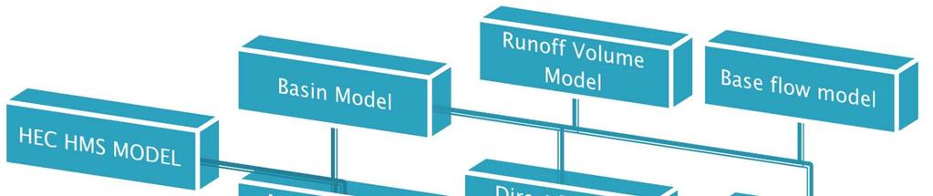

6 Sub Models used in HEC HMS
7 Adopted Model, methods and parameters Model Runoff Volume Model (Loss) Method SCS Curve Number Estimated Parameters Initial Abstraction, Curve Number, Impervious rate Direct Runoff Model (Transform) Clark Unit Hydrograph Time of Concentration, Storage Coefficient Base flow Model Recession Initial Discharge, Recession Constant, Threshold Flow Channel Flow Model Muskingum Routing Muskingum K and X Transform method: Clark Unit Hydrograph Model Time of Concentration (min) Kirpish s equation : T c = L 0.77 /S L = flow length (m) S = average slope along the flow path Loss method: SCS Curve Number Initial abstraction (mm) I a = 0.2*S S = ( *CN)/CN
8 Routing method: Muskingum Muskingum s parameters K K= L/u L = flow lenght U= flow velocity Muskingum s parameters X 0 X 0.5 CN LOSS SB1 SB2 SB3 SB4 SB5 SB6 SB7 Initial Abstraction SCS CN Impervious CLARK UNIT HYDROGRAPH Time of Concnt.(.(Hr Hr) Storage Coff (Hr Hr) RECESSION * Initial Discharge(m 3 /s) Recession Constant Threshold Ratio MUSKINGUM REACH1 REACH2 REACH3 REACH4 K(hr hr) X(hr hr) Methods and their parameters involved for normal condition


9 Storm I Storm II 4 th Nov-29 th Nov 1984 Two peak rainfall in 9 th and 15 th Nov. Two peak discharge Not wet environment Low initial soil moisture 13 th April 1976 to 22 nd April 1976 Only one peak discharge Wet environment -second rainiest time of year -Observing rainfall data before two week -Hence correction was applied in CN ecipitation and scharge plotted ainst time for Storm I


10 Sub Basins Curve Number Initial Abstraction Result obtained without calibration Changed parameters for normal condition a forest fire ult obtained after calibration (before forest fire) Storm after forest fire


11 ecipitation and ischarge plotted against e for Storm II Sub Basins Curve Number Initial Abstraction Changed parameters for wet condition before forest fire Sub Basins Curve Number Changed Curve Number for wet condition a forest fire


12 Second Storm before forest fire Second Storm after forest fire After forest fire, peak discharge increased in the range 10%- 50% In some instances, discharge rate was not in sync with precipitation Soil moisture amongst others was the possible cause Curve number varies from normal to wet condition Sensitivity analysis of the parameters is crucial for calibration Model can be improved by estimating the effect of soil moisture condition before the event and modeling for longer period

 scale Using TLS and ALS Might use statistical approaches like Random Forest, Baysein Hierarchical or")
13 Early warning system Can be used to predict flood risk and possibly save loss of life and property Attempted in Mediterranean region but can be used elsewhere Helps in mitigating the loss or building the protection in low cost Prevents erroneous flood forecasting Research in remote sensing Boise Center Aerospace Laboratory Scaling up plot level data to Lidar (ALS) scale Using TLS and ALS Might use statistical approaches like Random Forest, Baysein Hierarchical or even simple regression

14 Shital Dhakal (NEPAL) Graduate Research Assistant Boise Center Aerospace Laboratory Department of Geosciences Boise State University 1910 University Drive Boise, Idaho Phone:
Introduction. Keywords: Oil Palm, hydrology, HEC-HMS, HEC-RAS. a * b*
 The Effect of Land Changes Towards in Sg. Pandan Perwira Bin Khusairi Rahman 1,a* and Kamarul Azlan bin Mohd Nasir 1,b 1 Faculty of Civil Engineering, Universiti Teknologi Malaysia, Malaysia a * wirakhusairirahman@gmail.com,
Hydrologic Engineering Center Hydrologic Modeling System (HEC-HMS) Sunil KUMAR Director, National Water Academy
 Sunil KUMAR Director, National Water Academy") Hydrologic Engineering Center Hydrologic Modeling System (HEC-HMS) Sunil KUMAR Director, National Water Academy 22 April 2015 NWA, Pune Exercise Objective: To determine hydrological Response of the given
Hydrologic Engineering Center Hydrologic Modeling System (HEC-HMS) Sunil KUMAR Director, National Water Academy 22 April 2015 NWA, Pune Exercise Objective: To determine hydrological Response of the given
Estimation of Hydrological Outputs using HEC-HMS and GIS
 Nigerian Journal of Environmental Sciences and Technology (NIJEST) www.nijest.com ISSN (Print): 2616-051X ISSN (electronic): 2616-0501 Vol 1, No. 2 July 2017, pp 390-402 Estimation of Hydrological Outputs
RAINFALL - RUNOFF MODELING IN AN EXPERIMENTAL WATERSHED IN GREECE
 Proceedings of the 14 th International Conference on Environmental Science and Technology Rhodes, Greece, 3-5 September 2015 RAINFALL - RUNOFF MODELING IN AN EXPERIMENTAL WATERSHED IN GREECE KOTSIFAKIS
APPENDIX IV. APPROVED METHODS FOR QUANTIFYING HYDROLOGIC CONDITIONS OF CONCERN (NORTH ORANGE COUNTY)
") APPENDIX IV. APPROVED METHODS FOR QUANTIFYING HYDROLOGIC CONDITIONS OF CONCERN (NORTH ORANGE COUNTY) Hydromodification design criteria for the North Orange County permit area are based on the 2- yr, 24-hr
APPENDIX IV. APPROVED METHODS FOR QUANTIFYING HYDROLOGIC CONDITIONS OF CONCERN (NORTH ORANGE COUNTY) Hydromodification design criteria for the North Orange County permit area are based on the 2- yr, 24-hr
Event and Continuous Hydrological Modeling with HEC- HMS: A Review Study
 Event and Continuous Hydrological Modeling with HEC- HMS: A Review Study Sonu Duhan *, Mohit Kumar # * M.E (Water Resources Engineering) Civil Engineering Student, PEC University Of Technology, Chandigarh,
SECTION III: WATERSHED TECHNICAL ANALYSIS
 Trout Creek Watershed Stormwater Management Plan SECTION III: WATERSHED TECHNICAL ANALYSIS A. Watershed Modeling An initial step this study of the Trout Creek watershed was the selection of a stormwater
Impacts of Rainfall Event Pattern and Land-Use Change on River Basin Hydrological Response: a Case in Malaysia
 International Proceedings of Chemical, Biological and Environmental Engineering, Vol. 93 (2016) DOI: 10.7763/IPCBEE. 2016. V93. 23 Impacts of Rainfall Event Pattern and Land-Use Change on River Basin Hydrological
Hydrologic Engineering Center. Training Course on. Hydrologic Modeling with HEC-HMS. Davis, CA. Course Description
 Hydrologic Engineering Center Training Course on Hydrologic Modeling with HEC-HMS Davis, CA Course Description The course provides an introduction to HEC-HMS for new users, focusing both on using the program
FAST WATER / SLOW WATER AN EVALUATION OF ESTIMATING TIME FOR STORMWATER RUNOFF
 FAST WATER / SLOW WATER AN EVALUATION OF ESTIMATING TIME FOR STORMWATER RUNOFF Factors Affecting Stormwater Runoff: Rainfall intensity % Impervious surfaces Watershed size Slope Soil type, soil compaction
Hydrologic Engineering Center. Training Course on. Hydrologic Modeling with HEC-HMS April 2018 Davis, CA. Course Description
 Hydrologic Engineering Center Training Course on Hydrologic Modeling with HEC-HMS 23-27 April 2018 Davis, CA Course Description The course provides an introduction to HEC-HMS for new users, focusing both
Rainfall, Runoff and Peak Flows: Calibration of Hydrologic Design Methods for the Kansas City Area
 Rainfall, Runoff and Peak Flows: Calibration of Hydrologic Design Methods for the Kansas City Area Bruce McEnroe, Bryan Young, Ricardo Gamarra and Ryan Pohl Department of Civil, Environmental, and Architectural
INFLOW DESIGN FLOOD CONTROL SYSTEM PLAN 40 C.F.R. PART PLANT YATES ASH POND 3 (AP-3) GEORGIA POWER COMPANY
 GEORGIA POWER COMPANY") INFLOW DESIGN FLOOD CONTROL SYSTEM PLAN 40 C.F.R. PART 257.82 PLANT YATES ASH POND 3 (AP-3) GEORGIA POWER COMPANY EPA s Disposal of Coal Combustion Residuals from Electric Utilities Final Rule (40 C.F.R.
INFLOW DESIGN FLOOD CONTROL SYSTEM PLAN 40 C.F.R. PART 257.82 PLANT YATES ASH POND 3 (AP-3) GEORGIA POWER COMPANY EPA s Disposal of Coal Combustion Residuals from Electric Utilities Final Rule (40 C.F.R.
DEVELOPMENT OF A HYDRO-GEOMORPHIC MODEL FOR THE LAGUNA CREEK WATERSHED
 DEVELOPMENT OF A HYDRO-GEOMORPHIC MODEL FOR THE LAGUNA CREEK WATERSHED Agenda Background Hydro-Geomorphic Modeling Methodology HEC-HMS Modeling How is the Model Used Background Proposition 50 Grant Funding
Evaluation of the effects of underlying surface change on catchment hydrological response using the HEC-HMS model
 Evolving Water Resources Systems: Understanding, Predicting and Managing Water Society Interactions Proceedings of ICWRS2014, Bologna, Italy, June 2014 (IAHS Publ. 364, 2014). 145 Evaluation of the effects
MODULE 1 RUNOFF HYDROGRAPHS WORKSHEET 1. Precipitation
 Watershed MODULE 1 RUNOFF HYDROGRAPHS WORKSHEET 1 A watershed is an area of land thaaptures rainfall and other precipitation and funnels it to a lake or stream or wetland. The area within the watershed
The Texas A&M University and U.S. Bureau of Reclamation Hydrologic Modeling Inventory (HMI) Questionnaire
 Questionnaire") The Texas A&M University and U.S. Bureau of Reclamation Hydrologic Modeling Inventory (HMI) Questionnaire May 4, 2010 Name of Model, Date, Version Number Dynamic Watershed Simulation Model (DWSM) 2002
The Texas A&M University and U.S. Bureau of Reclamation Hydrologic Modeling Inventory (HMI) Questionnaire May 4, 2010 Name of Model, Date, Version Number Dynamic Watershed Simulation Model (DWSM) 2002
Reservoir on the Rio Boba
 Reservoir on the Rio Boba Michael J. Burns II Guillermo Bustamante J. James Peterson Executive Summary The National Institute of Water Resources in the Dominican Republic (INDRHI) plans to construct a
Hydrologic Calibration:
 Hydrologic Calibration: UPDATE OF EFFECTIVE HYDROLOGY FOR MARYS CREEK October 2010 Agenda Background Hydrologic model Calibrated rainfall Hydrologic calibration 100 year discharges, Existing Conditions
1 n. Flow direction Raster DEM. Spatial analyst slope DEM (%) slope DEM / 100 (actual slope) Flow accumulation
 slope DEM / 100 (actual slope) Flow accumulation") 1 v= R S n 2/3 1/2 DEM Flow direction Raster Spatial analyst slope DEM (%) Flow accumulation slope DEM / 100 (actual slope) 0 = no cell contributing 215 = 215 cell contributing towards that cell sqrt (actual
1 v= R S n 2/3 1/2 DEM Flow direction Raster Spatial analyst slope DEM (%) Flow accumulation slope DEM / 100 (actual slope) 0 = no cell contributing 215 = 215 cell contributing towards that cell sqrt (actual
SOUTHEAST TEXAS CONTINUING EDUCATION
 EXAM No. 118 FLOOD - RUNOFF ANALYSIS 1. Information gained from flood - runoff analysis includes which one: A. Stage, discharge, volume. B. Measure depth, volume. C. Velocity, depth, storm occurrence.
Hydrologic Study Report for Single Lot Detention Basin Analysis
 Hydrologic Study Report for Single Lot Detention Basin Analysis Prepared for: City of Vista, California August 18, 2006 Tory R. Walker, R.C.E. 45005 President W.O. 116-01 01/23/2007 Table of Contents Page
Learning objectives. Upon successful completion of this lecture, the participants will be able to describe:
 Solomon Seyoum Learning objectives Upon successful completion of this lecture, the participants will be able to describe: The different approaches for estimating peak runoff for urban drainage network
SECTION IV WATERSHED TECHNICAL ANALYSIS
 A. Watershed Modeling SECTION IV WATERSHED TECHNICAL ANALYSIS An initial step in the preparation of this stormwater management plan was the selection of a stormwater simulation model to be utilized. It
Impact Study of a check dam on Ground Water Recharge
 Impact Study of a check dam on Ground Water Recharge 1 P.Arun Raja, C. Dinesh, B.Jagadeesan 1,, UG Student, Department of Civil Engineering, Mamallan Institute of Technology, Kanchipuram, INDIA Abstract:
Chapter 6. Hydrology. 6.0 Introduction. 6.1 Design Rainfall
 6.0 Introduction This chapter summarizes methodology for determining rainfall and runoff information for the design of stormwater management facilities in the City. The methodology is based on the procedures
Drainage Analysis. Appendix E
 Drainage Analysis Appendix E The existing and proposed storm drainage systems have been modeled with Bentley CivilStorm V8 computer modeling software. The peak stormwater discharge was determined for
GISHYDRO: Developing Discharges and Watershed Parameters
 GISHYDRO: Developing Discharges and Watershed Parameters A Case Study with Baltimore City Watersheds by Mathini Sreetharan, Ph.D., P.E., CFM, Dewberry, VA Kim Dunn, P.E., CFM, Dewberry, PA Baltimore City
Rainfall - runoff: Unit Hydrograph. Manuel Gómez Valentín E.T.S. Ing. Caminos, Canales y Puertos de Barcelona
 Rainfall - runoff: Unit Hydrograph Manuel Gómez Valentín E.T.S. ng. Caminos, Canales y Puertos de Barcelona Options in many commercial codes,, HMS and others HMS Menu Transform method, User specified,
Ata Amini, Thamer Mohammad Ali, Abdul Halim B. Ghazali, Azlan A. Aziz & Shatirah Mohd. Akib
 Impacts of Land-Use Change on Streamflows in the Damansara Watershed, Malaysia Ata Amini, Thamer Mohammad Ali, Abdul Halim B. Ghazali, Azlan A. Aziz & Shatirah Mohd. Akib Arabian Journal for Science and
IJSER. within the watershed during a specific period. It is constructed
 International Journal of Scientific & Engineering Research, Volume 5, Issue 7, July-014 ISSN 9-5518 306 within the watershed during a specific period. It is constructed I. INTRODUCTION In many instances,
Hydrologic evaluation of flood flows from a burned watershed
 Flood Recovery, Innovation and Response II 257 Hydrologic evaluation of flood flows from a burned watershed A. W. Miller & E. J. Nelson Department of Civil & Environmental Engineering, Brigham Young University,
Module 3. Lecture 6: Synthetic unit hydrograph
 Lecture 6: Synthetic unit hydrograph Synthetic Unit Hydrograph In India, only a small number of streams are gauged (i.e., stream flows due to single and multiple storms, are measured) There are many drainage
5/25/2017. Overview. Flood Risk Study Components HYDROLOGIC MODEL (HEC-HMS) CALIBRATION FOR FLOOD RISK STUDIES. Hydraulics. Outcome or Impacts
 CALIBRATION FOR FLOOD RISK STUDIES. Hydraulics. Outcome or Impacts") HYDROLOGIC MODEL (HEC-HMS) CALIBRATION FOR FLOOD RISK STUDIES C. Landon Erickson, P.E.,CFM Water Resources Engineer USACE, Fort Worth District April 27 th, 2017 US Army Corps of Engineers Overview Flood
HYDROLOGIC MODEL (HEC-HMS) CALIBRATION FOR FLOOD RISK STUDIES C. Landon Erickson, P.E.,CFM Water Resources Engineer USACE, Fort Worth District April 27 th, 2017 US Army Corps of Engineers Overview Flood
Effects of initial abstraction ratio in SCS-CN method on modeling the impacts of urbanization on peak flows
 Effects of initial abstraction ratio in SCS-CN method on modeling the impacts of urbanization on peak flows Navideh Noori, Latif Kalin, Puneet Srivastava, Charlene LeBleu Proceedings ASCE World Environmental
Flood Modelling For Peri Urban Areas in Adyar River
 Flood Modelling For Peri Urban Areas in Adyar River Saranya VP 1 Assistant Professor, Department of Civil Engineering, Bannari Amman Institute of Technology, Erode, India 1 ABSTRACT: Water is essential
Examination of PRZM5.0 Storm Rainfall Depth and Distribution Algorithms Compared to Current U.S. Storm Trends
 Examination of PRZM5.0 Storm Rainfall Depth and Distribution Algorithms Compared to Current U.S. Storm Trends August 24, 2016 Tammara L. Estes (Stone Environmental Inc.) Kevin L. Armbrust, Ph.D. (Louisiana
HYDROLOGICAL MODELING OF AN AGRICULTURAL WATERSHED USING HEC-HMS HYDROLOGICAL MODEL, REMOTE SENSING AND GEOGRAPHICAL INFORMATION SYSTEM
 HYDROLOGICAL MODELING OF AN AGRICULTURAL WATERSHED USING HEC-HMS HYDROLOGICAL MODEL, REMOTE SENSING AND GEOGRAPHICAL INFORMATION SYSTEM Niravkumar K. Pampaniya 1, Mukesh K. Tiwari 2, M. L. Gaur 3 1 M.Tech.
San Luis Obispo Creek Watershed Hydrologic Model Inputs
 Jeff Werst San Luis Obispo County Department of Public Works 1050 Monterey Street San Luis Obispo CA 93408 December 14, 2007 Subject: San Luis Obispo Creek Watershed Hydrology and Hydraulic Model Dear
Development of a GIS Tool for Rainfall-Runoff Estimation
 Development of a GIS Tool for Rainfall-Runoff Estimation Ashraf M. Elmoustafa * M. E. Shalaby Ahmed A. Hassan A.H. El-Nahry Irrigation and Hydraulics Department, Ain Shams University, Egypt NARSS, Egypt
Modeling Infiltration BMPs
 Modeling Infiltration BMPs CAHILL ASSOCIATES Environmental Consultants West Chester, PA (610) 696-4150 www.thcahill.com Design Goals for Calculations 1. Mitigate Peak Rates 2-Year to 100-Year 2. No Volume
Figure 1: Overview of all AutoCAD generated cross-sections.
 RocScience Slope Stability Modeling Software RocScience s Slide is a program that was used to evaluate Odell Dam slope stability conditions. Slide is a 2D limit equilibrium slope stability program that
Simulation of Daily Streamflow
 US Army Corps of Engineers Hydrologic Engineering Center Simulation of Daily Streamflow April 1968 Approved for Public Release. Distribution Unlimited. TP-6 REPORT DOCUMENTATION PAGE Form Approved OMB
Estimating the 100-year Peak Flow for Ungagged Middle Creek Watershed in Northern California, USA
 American Journal of Water Resources, 2014, Vol. 2, No. 4, 99-105 Available online at http://pubs.sciepub.com/ajwr/2/4/3 Science and Education Publishing DOI:10.12691/ajwr-2-4-3 Estimating the 100-year
1. Stream Network. The most common approach to quantitatively describing stream networks was postulated by Strahler (1952).
.") 1. Stream Network The most common approach to quantitatively describing stream networks was postulated by Strahler (1952). First Order Streams streams with no tributaries. Second Order Streams begin at
1. Stream Network The most common approach to quantitatively describing stream networks was postulated by Strahler (1952). First Order Streams streams with no tributaries. Second Order Streams begin at
APPENDIX 4 ARROYO MODELING
 APPENDIX 4 ARROYO MODELING The existing HEC-HMS model can serve as a baseline for further development and analysis of major arroyos in the city. The model would need to be updated and expanded to consider
What is runoff? Runoff. Runoff is often defined as the portion of rainfall, that runs over and under the soil surface toward the stream
 What is runoff? Runoff Runoff is often defined as the portion of rainfall, that runs over and under the soil surface toward the stream 1 COMPONENTS OF Runoff or STREAM FLOW 2 Cont. The types of runoff
Estimation of Infiltration Parameter for Tehri Garhwal Catchment
 Estimation of Infiltration Parameter for Tehri Garhwal Catchment Ashish Bhatt 1 H L Yadav 2 Dilip Kumar 3 1 UG Student, Department of civil engineering, G B Pant Engineering College, Pauri, UK-246194 2,3
HYDROLOGIC MODELING CONSISTENCY AND SENSITIVITY TO WATERSHED SIZE
 HYDROLOGIC MODELING CONSISTENCY AND SENSITIVITY TO WATERSHED SIZE by James C.Y. Guo. Professor, Civil Engineering, U. Of Colorado at Denver, James.Guo@cudenver.edu.. And Eric Hsu, Project Engineer, Parson
RAINFALL-RUNOFF STUDY FOR SINGAPORE RIVER CATCHMENT
 10 th International Conference on Hydroinformatics HIC 2012, Hamburg, GERMANY RAINFALL-RUNOFF STUDY FOR SINGAPORE RIVER CATCHMENT CHI DUNG DOAN (1)(3), JIANDONG LIU (1), SHIE-YUI LIONG (1), ADRI VERWEY
5/11/2007. WinTR-55 for Plan Reviewers Small Watershed Hydrology Hydrology Terms and Definitions
 WinTR-55 for Plan Reviewers Small Watershed Hydrology Hydrology Terms and Definitions 1 Course Outline Overview Review of Hydrology Terms and Definitions Modeling Single Sub-area Watersheds Multiple Sub-area
Simulation of Event Based Runoff Using HEC-HMS Model for an Experimental Watershed
 International Journal of Hydraulic Engineering 213, 2(2): 28-33 DOI: 1.5923/j.ijhe.21322.2 Simulation of Event Based Runoff Using HEC-HMS Model for an Experimental Watershed Reshma T *, Venkata Reddy K,
Suspended Sediment Discharges in Streams
 US Army Corps of Engineers Hydrologic Engineering Center Suspended Sediment Discharges in Streams April 1969 Approved for Public Release. Distribution Unlimited. TP-19 REPORT DOCUMENTATION PAGE Form Approved
Application of HEC-HMS for Flood Forecasting in Kabkian Basin and Delibajak Subbasin in Iran
 IOSR Journal of Engineering (IOSRJE) e-iss: 2250-3021, p-iss: 2278-8719 Vol. 3, Issue 9 (September. 2013), V3 PP 10-16 Application of HEC-HMS for Flood Forecasting in Kabkian Basin and Delibajak Subbasin
Autumn semester of Prof. Kim, Joong Hoon
 1 Autumn semester of 2010 Prof. Kim, Joong Hoon Water Resources Hydrosystems System Engineering Laboratory Laboratory 2 A. HEC (Hydrologic Engineering Center) 1 Established in the U.S. Army Corps of Engineers(USACE)
BMP Design Aids. w w w. t r a n s p o r t a t i o n. o h i o. g o v. Equations / Programs
 BMP Design Aids 1 Equations / Programs Outlet Discharge Equations Hydrograph and Pond Routing Programs USGS StreamStats 2 Ohio Department of Transportation 1 Training Intent Introduction and overview of
INFLOW DESIGN FLOOD CONTROL SYSTEM PLAN PLANT BARRY ASH POND ALABAMA POWER COMPANY
 INFLOW DESIGN FLOOD CONTROL SYSTEM PLAN PLANT BARRY ASH POND ALABAMA POWER COMPANY Section 257.82 of EPA s regulations requires the owner or operator of an existing or new CCR surface impoundment or any
Introduction to Hydrology, Part 2. Notes, Handouts
 Introduction to Hydrology, Part 2 Notes, Handouts Precipitation Much of hydrology deals with precipitation How much? How frequently/infrequently? What form? How quickly? Seasonal variation? Drought frequency?
Hydrology and Water Management. Dr. Mujahid Khan, UET Peshawar
 Hydrology and Water Management Dr. Mujahid Khan, UET Peshawar Course Outline Hydrologic Cycle and its Processes Water Balance Approach Estimation and Analysis of Precipitation Data Infiltration and Runoff
UPDATE OF ARC TP108 RUN-OFF CALCULATION GUIDELINE
 UPDATE OF ARC TP108 RUN-OFF CALCULATION GUIDELINE Bodo Hellberg, Stormwater Action Team, Auckland Regional Council Matthew Davis, Stormwater Action Team, Auckland Regional Council ABSTRACT This paper focuses
Planning Considerations for Stormwater Management in Alberta. R. D. (Rick) Carnduff, M. Eng., P. Eng. February 20, 2013.
 Carnduff, M. Eng., P. Eng. February 20, 2013.") Planning Considerations for Stormwater Management in Alberta R. D. (Rick) Carnduff, M. Eng., P. Eng. February 20, 2013 Photo Optional Purpose The purpose of urban stormwater management is to provide solutions
Planning Considerations for Stormwater Management in Alberta R. D. (Rick) Carnduff, M. Eng., P. Eng. February 20, 2013 Photo Optional Purpose The purpose of urban stormwater management is to provide solutions
Distribution Restriction Statement Approved for public release; distribution is unlimited.
 CECW-EH-Y Regulation No. 1110-2-1464 Department of the Army U.S. Army Corps of Engineers Washington, DC 20314-1000 Engineering and Design HYDROLOGIC ANALYSIS OF WATERSHED RUNOFF Distribution Restriction
Introduction, HYDROGRAPHS
 HYDROGRAPHS Sequence of lecture Introduction Types of Hydrograph Components of Hydrograph Effective Rainfall Basin Lag or Time Lag Parts of Hydrograph Hydrograph Analysis Factors Affecting Hydrograph Shape
INFLOW DESIGN FLOOD CONTROL SYSTEM PLAN 40 C.F.R. Part PLANT MCINTOSH ASH POND 1 GEORGIA POWER COMPANY
 INFLOW DESIGN FLOOD CONTROL SYSTEM PLAN 40 C.F.R. Part 257.82 PLANT MCINTOSH ASH POND 1 GEORGIA POWER COMPANY EPA s Disposal of Coal Combustion Residuals from Electric Utilities Final Rule (40 C.F.R. Part
2
 1 2 3 4 5 6 The program is designed for surface water hydrology simulation. It includes components for representing precipitation, evaporation, and snowmelt; the atmospheric conditions over a watershed.
Comparison and Assessment of Success of Models in Watershed Simulation and Management
 Journal of Water Resource and Protection, 2014, 6, 599-608 Published Online April 2014 in SciRes. http://www.scirp.org/journal/jwarp http://dx.doi.org/10.4236/jwarp.2014.66058 Comparison and Assessment
INFLOW DESIGN FLOOD CONTROL SYSTEM PLAN PLANT GREENE COUNTY ASH POND ALABMA POWER COMPANY
 INFLOW DESIGN FLOOD CONTROL SYSTEM PLAN PLANT GREENE COUNTY ASH POND ALABMA POWER COMPANY Section 257.82 of EPA s regulations requires the owner or operator of an existing or new CCR surface impoundment
URBAN FLOODING: HEC-HMS
 1.0 Introduction URBAN FLOODING: HEC-HMS -Sunil Kumar, Director, NWA All major ancient civilisations were developed in the river valleys because river served as source of water, food, transportation and
University of the Philippines and the Department of Science and Technology 2015
 University of the Philippines and the Department of Science and Technology 2015 Published by the UP Training Center for Applied Geodesy and Photogrammetry (TCAGP) College of Engineering University of the
APPENDIX E APPENDIX E ESTIMATING RUNOFF FOR SMALL WATERSHEDS
 APPENDIX E ESTIMATING RUNOFF FOR SMALL WATERSHEDS March 18, 2003 This page left blank intentionally. March 18, 2003 TABLES Table E.1 Table E.2 Return Frequencies for Roadway Drainage Design Rational Method
TECHNICAL MEMORANDUM. SUBJECT: Determination of watershed historic peak flow rates as the basis for detention basin design
 TECHNICAL MEMORANDUM FROM: Ken MacKenzie and Ryan Taylor SUBJECT: Determination of watershed historic peak flow rates as the basis for detention basin design DATE: June 7, 2012 The purpose of this memorandum
Stormwater: Too Simple?
 Stormwater: Too Simple? Getting Closer to Advertised Level of Service Brandon Klenzendorf, Ph.D., P.E. 13 December 2017 - CWEA Fall Seminar Introduction Traditional approaches to solving stormwater problems
History of Model Development at Temple, Texas. J. R. Williams and J. G. Arnold
 History of Model Development at Temple, Texas J. R. Williams and J. G. Arnold INTRODUCTION Then Model development at Temple A long history (1937-present) Many scientists participating in: Data collection
APPENDIX E ESTIMATING RUNOFF FROM SMALL WATERSHEDS
 ESTIMATING RUNOFF FROM SMALL WATERSHEDS June 2011 THIS PAGE LEFT BLANK INTENTIONALLY. June 2011 TABLES Table E.1 Table E.2 Return Frequencies for Roadway Drainage Design Rational Method Values June 2011
LAKE COUNTY HYDROLOGY DESIGN STANDARDS
 LAKE COUNTY HYDROLOGY DESIGN STANDARDS Lake County Department of Public Works Water Resources Division 255 N. Forbes Street Lakeport, CA 95453 (707)263-2341 Adopted June 22, 1999 These Standards provide
Overview of NRCS (SCS) TR-20 By Dr. R.M. Ragan
 TR-20 By Dr. R.M. Ragan") Overview of NRCS (SCS) TR-20 By Dr. R.M. Ragan TR-20 is a computer program for the simulation of runoff occurring from a single storm event. The program develops flood hydrographs from runoff and routes
Overview of NRCS (SCS) TR-20 By Dr. R.M. Ragan TR-20 is a computer program for the simulation of runoff occurring from a single storm event. The program develops flood hydrographs from runoff and routes
Synthesis of Unit Hydrographs for Texas Watersheds
 Synthesis of Unit Hydrographs for Texas Watersheds Theodore G. Cleveland, UH William H. Asquith, USGS David B. Thompson, R.O. Anderson Xing Fang, Auburn University July 17, 2007 Acknowledgements Research
THE BIGGER THE BETTER? HOW SPATIAL RESOLUTION AFFECT RUNOFF MODELING AND WATERSHED DELINEATION INTRODUCTION
 THE BIGGER THE BETTER? HOW SPATIAL RESOLUTION AFFECT RUNOFF MODELING AND WATERSHED DELINEATION David Alvarez CDM 1715 North Westshore Boulevard Suite 875 Tampa, FL 33607 email: alvarezd@cdm.com Barrett
Unit 2: Geomorphologic and Hydrologic Characteristics of Watersheds. ENVS 435: Watershed Management INSTR.: Dr. R.M. Bajracharya
 Unit 2: Geomorphologic and Hydrologic Characteristics of Watersheds ENVS 435: Watershed Management INSTR.: Dr. R.M. Bajracharya Watersheds are hydro-geologic units Water flow and cycling are basic and
Pilot Study for Storage Requirements for Low Flow Augmentation
 US Army Corps of Engineers Hydrologic Engineering Center Pilot Study for Storage Requirements for Low Flow Augmentation April 1968 Approved for Public Release. Distribution Unlimited. TP-7 REPORT DOCUMENTATION
Chapter 6. The Empirical version of the Rational Method
 Chapter 6 The Empirical version of the Rational Method The Empirical version is named because the parameters it uses (apart from rainfall data) are arbitrary and are generally based on experience or observation
Calibration of Hydrologic Design Inputs for a Small Urban Watershed
 Research Project Proposal for Johnson County Stormwater Management Program and City of Overland Park, Kansas Calibration of Hydrologic Design Inputs for a Small Urban Watershed Bruce M. McEnroe & C. Bryan
Flood hazard assessment in the Raval District of Barcelona using a 1D/2D coupled model
 9 th International Conference on Urban Drainage Modelling Belgrade 2012 Flood hazard assessment in the Raval District of Barcelona using a 1D/2D coupled model Beniamino Russo, David Suñer, Marc Velasco,
INFLOW DESIGN FLOOD CONTROL SYSTEM PLAN 40 C.F.R. PART PLANT DANIEL ASH POND B MISSISSIPPI POWER COMPANY
 INFLOW DESIGN FLOOD CONTROL SYSTEM PLAN 40 C.F.R. PART 257.82 PLANT DANIEL ASH POND B MISSISSIPPI POWER COMPANY EPA s Disposal of Coal Combustion Residuals from Electric Utilities Final Rule (40 C.F.R.
Basic Hydrology Runoff Curve Numbers
 Basic Hydrology Runoff Curve Numbers By: Paul Schiariti, P.E., CPESC Mercer County Soil Conservation District The SCS Runoff Curve Number The RCN (Runoff Curve Number) method was originally established
Hydromodification Management Plan. Draft Report Chapters 4-6. Lower Silver - Thompson Creek Subwatershed. April 7, 2003
 Hydromodification Management Plan Draft Report Chapters 4-6 Lower Silver - Thompson Creek Subwatershed April 7, 2003 by GeoSyntec Consultants Walnut Creek, CA 94596 Balance Hydrologics, Inc. Berkeley,
San Antonio Water System Mitchell Lake Constructed Wetlands Below the Dam Preliminary Hydrologic Analysis
 San Antonio Water System enhancement. This recommendation was based on limited water quality data provided by SAWS and using a free-water surface constructed wetland with approximately 112 acres of wetted
ASSESSMENT OF DRAINAGE CAPACITY OF CHAKTAI AND RAJAKHALI KHAL IN CHITTAGONG CITY AND INUNDATION ADJACENT OF URBAN AREAS
 Proceedings of the 4 th International Conference on Civil Engineering for Sustainable Development (ICCESD 2018), 9~11 February 2018, KUET, Khulna, Bangladesh (ISBN-978-984-34-3502-6) ASSESSMENT OF DRAINAGE
Alternative Approaches to Water Resource System Simulation
 US Army Corps of Engineers Hydrologic Engineering Center Alternative Approaches to Water Resource System Simulation May 1972 Approved for Public Release. Distribution Unlimited. TP-32 REPORT DOCUMENTATION
Introduction to HEC HMS. Daene C. McKinney
 CE 374 K Hydrology Introduction to HEC HMS Daene C. McKinney Hydrologic Engineering Center U.S. Army Corps ofengineers (USACE) Hydrologic Engineering Center (HEC) Formed 1964 to institutionalize the technical
A&M WATERSHED MODEL USERS MANUAL WATER RESOURCES ENGINEERING
 TWRI Special Report 90-1 A&M WATERSHED MODEL USERS MANUAL by: Wesley P. James Phillip W. Winsor, John F. Bell Melvin G. Spinks, Alfred J. Garcia Dan Pridal, John Warinner Kelly Kaatz, Veronica Morgan Mike
RETENTION BASIN EXAMPLE
 -7 Given: Total Tributary Area = 7.5 ac o Tributary Area within Existing R/W = 5.8 ac o Tributary Area, Impervious, Outside of R/W = 0.0 ac o Tributary Area, Pervious, Outside of R/W = 1.7 ac o Tributary
Physically-based Distributed Hydrologic Modeling
 Physically-based Distributed Hydrologic Modeling Goal of Phys.-based Distrib. Hydrologic Modeling To date we have learned about: Key forcings at land surface (precipitation/net radiation) Physical processes
PRELIMINARY ANALYSIS OF THE AFFORESTATION ROLE IN THE MAXIMUM RUNOFF IN VALEA RECE CATCHMENT. Andreea Mihalcea 1
 DOI 10.1515/pesd-2017-0016 PESD, VOL. 11, no. 1, 2017 PRELIMINARY ANALYSIS OF THE AFFORESTATION ROLE IN THE MAXIMUM RUNOFF IN VALEA RECE CATCHMENT Andreea Mihalcea 1 Key-words: afforestation degree, runoff,
Computation of excess stormflow at the basin scale. Prof. Pierluigi Claps. Dept. DIATI, Politecnico di Torino
 Computation of excess stormflow at the basin scale Prof. Pierluigi Claps Dept. DIATI, Politecnico di Torino Pierluigi.claps@polito.it losses include: interception, evapotranspiration, storage infiltration,
1.6 Influence of Human Activities and Land use Changes on Hydrologic Cycle
 1.6 Influence of Human Activities and Land use Changes on Hydrologic Cycle Watersheds are subjected to many types of changes, major or minor, for various reasons. Some of these are natural changes and
Hydrology and Hydraulic Modeling for Flash Floods Risk Assessment and Mapping
 Hydrology and Hydraulic Modeling for Flash Floods Risk Assessment and Mapping A Methodology Proposal Konstantinos Papatheodorou Eleni A. Tzanou Konstantinos Ntouros Flash Flood Assessment From Regional
ENGINEERING HYDROLOGY
 ENGINEERING HYDROLOGY Prof. Rajesh Bhagat Asst. Professor Civil Engineering Department Yeshwantrao Chavan College Of Engineering Nagpur B. E. (Civil Engg.) M. Tech. (Enviro. Engg.) GCOE, Amravati VNIT,
Computer Determination of Flow Through Bridges
 US Army Corps of Engineers Hydrologic Engineering Center Computer Determination of Flow Through Bridges July 1970 Approved for Public Release. Distribution Unlimited. TP-20 REPORT DOCUMENTATION PAGE Form
Hypothetical Flood Computation for a Stream System
 US Army Corps of Engineers Hydrologic Engineering Center Hypothetical Flood Computation for a Stream System December 1968 Approved for Public Release. Distribution Unlimited. TP-12 REPORT DOCUMENTATION