ACKNOWLEDGEMENTS. Sincerely, Executive Director and Staff. Rockingham Planning Commission. 156 Water Street Exeter, NH (603)
|
|
|
- Rosanna Perkins
- 6 years ago
- Views:
Transcription
1

2 ACKNOWLEDGEMENTS The gratefully acknowledges the participation of coastal New Hampshire municipalities in the preparation of this report: City of Portsmouth Town of New Castle Town of Rye Town of North Hampton Town of Hampton Town of Hampton Falls Town of Seabrook The Tides to Storms project was enhanced by the willingness of these municipalities to support preparation of a coastal vulnerability assessment for New Hampshire. These municipalities contributed a great deal of staff hours to support this effort and their elected officials, land use boards and commissions, and volunteers participated in roundtable discussions to review maps and assessment data, and share their perspectives about how coastal hazards impact their community. We thank each municipality and their representatives for their contributions to this project. Sincerely, Executive Director and Staff 156 Water Street Exeter, NH (603) Use and Applicability of this Report and Results: The purpose of this vulnerability assessment report is to provide a broad overview of the potential risk and vulnerability of state, municipal and public assets as a result of projected changes in sea-levels and coastal storm surge. This report should be used for preliminary and general planning purposes only, not for parcel level or site specific analyses. The vulnerability assessment performed was limited by several factors including the vertical accuracy of elevation data (derived from LiDAR) and the static analysis applied to map coastal areas subject to future flooding which does not consider wave action and other coastal dynamics. Also, the identification of flood impacts to buildings and infrastructure are based upon the elevations of the land surrounding them, not the elevation of any structure itself. The changes in sealevel used as the basis of the vulnerability assessment are based on a plausible range of sea-level scenarios as depicted in the 2014 National Climate Assessment and New Hampshire Coastal Risks and Hazards Commission Science and Technical Advisory Committee 2014 report, and are not projections or estimates. The assumptions that underlie the sea-level scenarios should be reviewed on a regular basis. Last revised: September 18, 2015 Page i

3 TABLE OF CONTENTS I. Executive Summary 1 II. Introduction 7 III. Climate Change in New Hampshire 8 IV. Mapping and Assessment Methods 16 V. Vulnerability Assessment Results 22 VI. Regional Planning Recommendations 35 VII. Glossary 45 Appendix A Regional Map Set 47 Appendix B Outreach Materials 48 Original document dated September 6, 2015 and last revised September 18, This project is funded by New Hampshire Homeland Security and Emergency Management (HSEM) through a Pre-Disaster Mitigation Grant from the Federal Emergency Management Agency (FEMA). Additional funding for this project provided by the NH Department of Transportation through Federal Highways Administration. Technical support and data provided by NH GRANIT. Last revised: September 18, 2015 Page ii
4 List of Maps Map 1N. Extent of Projected Tidal Flooding (North) - 1.7, 4.0, 6.3 Map 1S. Extent of Projected Tidal Flooding (South) - 1.7, 4.0, 6.3 Map 2N. Extent of Projected Tidal Flooding (North) + Storm Surge Map 2S. Extent of Projected Tidal Flooding (South) + Storm Surge Map 3N. Critical Facilities and Infrastructure (North) - 1.7, 4.0, 6.3 Map 3S. Critical Facilities and Infrastructure (South) 1.7, 4.0, 6.3 Map 4N. Critical Facilities and Infrastructure (North) + Storm Surge Map 4S. Critical Facilities and Infrastructure (South) - + Storm Surge Map 5N. Roads and Transportation Assets (North) - 1.7, 4.0, 6.3 Map 5S. Roads and Transportation Assets (South) - 1.7, 4.0, 6.3 Map 6N. Roads and Transportation Assets (North) + Storm Surge Map 6S. Roads and Transportation Assets (South) + Storm Surge Map 7. Existing and Recommended Conservation Areas - 1.7, 4.0, 6.3 Map 8. Existing and Recommended Conservation Areas + Storm Surge Map 9. Wetlands, Aquifers, Wellhead Protection Area - 1.7, 4.0, 6.3 Map 10. Wetlands, Aquifers, Wellhead Protection Area + Storm Surge Map 11. Agricultural Soils - 1.7, 4.0, 6.3 Map 12. Agricultural Soils + Storm Surge Map 13. Regional Zoning - 1.7, 4.0, 6.3 Map 14. Regional Land Use - 1.7, 4.0, 6.3 Map 15. Evacuation Routes, Pipelines, and Other - 1.7, 4.0, 6.3 Map 16. Evacuation Routes, Pipelines, and Other + Storm Surge Map 17. Depth of Flooding, Sea-level rise 1.7' Map 18. Depth of Flooding, Sea-level rise 4.0' Map 19. Depth of Flooding, Sea-level rise 6.3' Map 20. Depth of Flooding - Sea-level rise 1.7' + Storm Surge Map 21. Depth of Flooding - Sea-level rise 4.0' + Storm Surge Map 22. Depth of Flooding - Sea-level rise 6.3' + Storm Surge Map 23. Preliminary FEMA Flood Hazard Areas - 1.7, 4.0, 6.3 Map 24. Preliminary FEMA Flood Hazard Areas + Storm Surge Last revised: September 18, 2015 Page iii


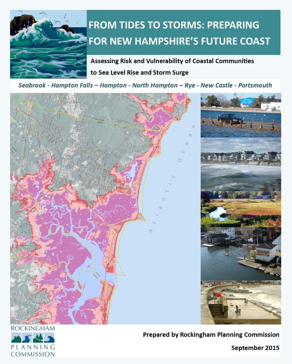
5 Assessing Risk and Vulnerability to Sea-level rise and Storm Surge: A Vulnerability Assessment of Coastal New Hampshire I. Executive Summary New Hampshire coastal municipalities are confronted by land use and hazard management concerns that include extreme weather events, storm surges, flooding and erosion. Concerns about issues are heightened by increases in the frequency and intensity of extreme storm events and increases in sea level. New Hampshire coastal communities have a distinct and pressing need to address the existing and future impacts relating to climate change, particularly relating to coastal flooding from storm surge and sea-level rise. Without proactive solutions to address the expected impacts of climate change, coastal communities face a multitude of challenges to ensure the security, health and welfare of their citizens and provide for a stable and viable economic future. In September 2015 the (RPC) completed the Tides to Storms project to assess the vulnerability of coastal municipalities and public infrastructure to flooding from expected increases in storm surge and rates of sea-level rise. The project s purpose was to develop a regional scale understanding of what and where impacts from sea-level rise and storm surge will occur on New Hampshire s coast. The geographic extent of the project includes the following municipalities: Portsmouth, New Castle, Rye, North Hampton, Hampton, Hampton Falls and Seabrook. The study did not include an assessment of the specific degree of damage nor estimate monetary losses to specific sites or properties. Further depth-damage analyses of affected assets using the flood depth maps may yield some of this information in follow-up work. The data generated from this project will enable individual communities, agencies and researchers to undertake this work in the future. In addition to the regional vulnerability assessment, an assessment report and map set were prepared for each of the seven coastal municipalities. Municipalities were provided maps and an assessment of risks to roadways and supporting transportation infrastructure, critical facilities and infrastructure, and natural resources. Flooding scenario maps were based on the 2014 National Climate Assessment, 2015 (Preliminary) Flood Insurance Rates Maps released by the Federal Emergency Management Agency (FEMA), and high resolution digital elevation data. This information was supplemented with a series of recommended actions that municipalities can take to help adapt and improve resiliency to changing conditions caused by storm surge and sea-level rise. The information and recommendations from this project should be considered for incorporation into local hazard mitigation plans. The information can also be incorporated into other state and municipal plans, policies, practices and regulatory standards. Last revised: September 18, 2015 Page 1
6 Data sources and assumptions that underlie the flood scenarios used in this assessment are explained more fully in Section IV of this report. SUMMARY OF VULNERABILITY ASSESSMENT RESULTS Key findings of the coastal assessment are based on evaluation of the extent of inundation that would result under three scenarios of static sea-level rise: 1.7 feet ( intermediate-low ), 4.0 feet ( intermediate high ), and 6.3 feet ( highest ) for the year 2100 and three additional scenarios that combine the static sea-level rise combined with the 100-year storm surge. In addition separate regional maps were prepared which mapped the depth of flooding associated with each scenario. An analysis was conducted to determine the intersection of inundation areas with key assets, including transportation, critical facilities (community defined) infrastructure and natural resources to evaluate the quantitative impacts of the flooding. Table 1 provides a statistical overview of the flood impacts to specific assets and resource types from the sealevel rise and storm surge scenarios evaluated. A few of the findings discussed in more detail in the body of the report are these: In most instances, the greatest increase in flood impacts occurs from the transition from the intermediate low (1.7 feet) to the intermediate high (4.0) feet sea-level rise scenarios. The miles of local roadways impacted by flooding is at least double the miles of state roadways affected under all six flood scenarios in all seven coastal municipalities. Sea-Level Rise () Scenarios TABLE 1. SUMMARY OF FLOOD IMPACTS FROM SEA-LEVEL RISE AND STORM SURGE 1.7 feet feet feet 4.0 feet 6.3 feet storm surge storm surge 6.3 feet + storm surge Infrastructure (# of sites) Critical Facilities (# of sites) Roadways Local (miles) Roadways - State (miles) Transportation Assets (# of sites) Upland (acres) 1, , , , , ,298.4 Freshwater Wetlands (acres) Tidal Wetlands (acres) Conserved and Public Lands (acres) , ,131.0 Conservation Focus Areas (acres) 4, , , , , ,458.3 Wildlife Action Plan Tier I+II (acres) Tier 1 and Tier 2 habitats (acres) 1, , , , , , year floodplain (acres) 8, , , , , , year floodplain (acres) 8, , , , , ,069.5 Note: Upland refers to land above mean higher high water (highest tidal extent). The seven coastal region municipalities have approximately 52,751.8 acres of upland. Storm surge = 100-year / 1% chance flood event. The seven coastal municipalities combined have 49,266 acres of upland (land above mean higherhigh water). At the lowest scenario, about 3% (1484 acres) of this upland will be inundated by tides on a regular basis; at the intermediate high scenario, 5.3% (2602 acres) of upland would be affected and at the highest scenario, 7.3% or 3613 acres would be affected. Upland impacts are Last revised: September 18, 2015 Page 2
7 greater in Rye than in other communities because of the extensive low-lying areas around the marshes west of Odiorne Point. Over500 acres of current freshwater wetlands would be subject tidal inflows under the highest (6.3 feet) scenario (non-storm surge). Portsmouth, Rye, Hampton and Seabrook have the greatest number of acres of conserved lands and public lands within the coastal floodplain. Although impacted by sea-level rise and coastal storm surge flooding, these undeveloped lands serve as important flood storage areas and allow space for future habitat conversation and salt marsh migration. Projected sea-level rise and coastal storm surge flooding are largely contained within the current 100-year floodplain with minor incursions within the 500-year floodplain in lowest lying areas. Roadways and Transportation Assets Route 1-A provides the vital transportation link on the immediate coast and is essential to coastal communities for access, safety, livability, recreation and for the continued viability of coastal tourist economy. With its immediate shoreline exposure, it comes as no surprise that Route 1-A is the transportation asset most vulnerable coastal flooding and disruption from sea-level rise scenarios. As shown in the project maps, the route and any connecting streets and roads are significantly affected by sea-level rise in the intermediate high and high scenarios. I-A is the backbone of the road network on the immediate coast for all of the communities (except Hampton Falls) and is essential for maintaining a function roadway system. To a great extent local responses on municipal roads will depend on State plans for improving the resilience of Route 1A and will require extensive regional coordination. Critical Facilities and Infrastructure Communities recognize the critical importance ensuring that emergency facilities and shelters be located in places that are secure and accessible. With existing coastal flood hazards in mind, relatively few although critical facilities are located in vulnerable locations including the Hampton Police Station and Fire Station, and the Hampton and Seabrook wastewater treatment facilities. Given the cost of making certain infrastructure and critical facilities more resilient, it is important that upgrades be budgeted as part of a long term capital improvement and included in cost estimates for new projects and facilities. Land Use As stated in section VI.2 General Considerations, the best way to limit the region s property and infrastructure exposure to future sea-level rise is to ensure that future development is limited in those vulnerable areas. Future land use polices that discourage further development in areas that will become vulnerable in a future 100-year storm will extend that protection and limit future losses. The adjacent upland areas that would be protected with this approach will also serve as critical flood storage in future storms and support marsh migration. Implementation strategies include land conservation/property acquisition, conservation subdivision, transfer of development rights, restoration of natural vegetation and adaptive repurpose/reuse. Natural Resources and Environment The coastal region is home to a wide variety of natural resources and ecosystems, including tidal and freshwater wetlands, salt marsh systems, estuarine systems, beaches, dunes, freshwater aquifers, and farm and forest land. Many of these natural areas provide significant economic value to the state and critical ecosystem services that protect assets and infrastructure, however many of these resources are also highly vulnerable to impacts from sea-level rise and storm surge. Salt marshes are particularly sensitive to changes in sea level. If marsh elevations can t keep pace with water elevations their capacity to store flood water during coastal storm events may be diminished. Many tools can be applied to protect these critical services including Last revised: September 18, 2015 Page 3
8 land conservation and acquisition, land development regulations, zoning standards, and municipal policies and plans. Assessed Value of Parcels Tables 2 and 17 report the number of parcels affected by each of the six scenarios evaluated and shows the aggregated assessed value of these parcels. The extent to which the parcel and any structure or development on the parcel is affected by sea-level rise or storm related flooding was not analyzed. Affected parcels were identified based on whether the parcel was either partially or fully within the extent of the scenarios evaluated. The data includes a number of high value parcels under state and municipal ownership. Between 2,800 to 5,700 parcels will be partially or wholly effected by tidal flooding, depending on the scenario, and up to 7,200 affected when storm surge is added. The data shows a 55 percent increase in the number of parcels and a $651 million dollar increase in the assessed value of parcels when comparing the 1.7 feet to the 4.0 feet sea-level rise scenario. This compares to a 32 percent increase in the number of parcels and a $659 million increase in the assessed value of parcels when comparing the 4.0 feet to the 6.3 feet sealevel rise scenario. TABLE 2. SUMMARY OF PARCELS AND ASSESSED VALUE BY SCENARIO Sea-Level Rise () Scenarios Number of Parcels Affected by scenario Aggregate Value of Effected Parcels 1.7 feet 2,789 $1,298,033, feet 4,334 $1,949,171, feet 5,740 $2,608,930, feet + storm surge 5,555 $2,555,831, feet + storm surge 6,468 $2,988,594, feet + storm surge 7,165 $3,258,843,274 Mapping shows that the three sea-level rise scenarios are for the most part contained within the current 100-year floodplain. To qualify for federal disaster relief and the National Flood Insurance Program, FEMA requires municipalities to regulate development within the 100-year floodplain. These floodplain standards are considered minimum requirements. FEMA encourages municipalities to adopt stricter floodplain standards and offers incentive programs such as the Community Rating System (CRS) which qualifies property owners to pay lower insurance premiums. CRS is a voluntary program that requires municipalities to adopt protective standards within highly vulnerable areas and take proactive actions that reduce flood risks. Creating more flood resiliency within the current 100-year floodplain may also provide flood protection against impacts from sea-level rise in the long term. Last revised: September 18, 2015 Page 4
9 Planning Considerations In order to effectively adapt in short-term and long term, municipalities need help developing and implementing policies and regulations to plan for and minimize the impacts of climate induced changes. Planning for climate change can result in positive actions that improve preparedness and reduce impacts from current coastal hazards and address long-term changes that may result from climate change including sea-level rise. Communities that implement climate adaptation planning may see benefits such as: Enhancing preparedness and community awareness of future flood risks. Identifying cost-effective measures to protect and adapt to changing conditions. Improving resiliency of infrastructure, buildings and other community investments. Protecting life, property and local economies. Protecting coastal natural resources and the critical services they provide. Preserving historical assets and unique community character. The Tides to Storms Coastal Vulnerability Assessment is a snapshot of existing conditions in coastal New Hampshire based on the current distribution of developed lands and natural landscapes and resources for the year As the developed and natural landscapes in the coastal region change, and climate parameters change, so will the degree and extent of impact from sea-level rise and coastal storm surge flooding. In order to use the latest science-based information to guide decision making, it is highly recommended that vulnerability assessments be updated as new information about emerging trends and revised projections of climate change are published. From state and regional perspectives, the increased risk of exposure to coastal flooding from changing sea level raises a number of important issues that should be considered and addressed in state, regional and local responses to increased coastal flood risks. There are both general considerations that apply to our collective response as well as considerations that apply to the specific asset classes affected (e.g. roads, infrastructure, natural resources). These considerations are listed below and discussed in detail in Section VI.2 Regional Considerations. Acting in uncertainty and the value of an incremental response: The most difficult circumstance under which to take action in response to a future threat is when there is uncertainty about the degree of risk from that threat. This is especially true when the threat is distant in time and the cost of responding is high. Each situation needs to be evaluated individually taking into consideration many factors. The value of time and of acting now: Acting today may result in long term cost savings by anticipating sea level change and ensuring all current and future infrastructure investments in vulnerable areas are resilient to at least moderate sea-level rise expected over their design life. State and regional economic considerations: Coastal New Hampshire is highly important to the region s and the state s economy. Statewide, tourism ranks as the state s second largest economic sector, and, for several communities in the coastal region, it is the largest. Much of that tourism activity is driven by access to coastal assets including beaches and the ocean. State and municipal collaboration, coordination and planning: The state and municipalities share assets and infrastructure on the coast and as such need to align their policies, assumptions and responses to Last revised: September 18, 2015 Page 5
10 existing and future coastal flood hazards to the greatest extent possible. Failure to coordinate such actions will increase the cost and decrease the effectiveness of planning and preparation for increased flood risk. Creative financing mechanisms for infrastructure projects: Creating more resilient buildings and infrastructure will cost more in the short term and may accelerate the need for certain improvements. This may necessitate innovative financing approaches to make such investments workable. For example, establishing a hazard mitigation fund to enable state agencies or municipalities to purchase developed properties in high hazard locations, or in undeveloped areas. Comprehensive shoreline management planning: A comprehensive shoreline management plan would identify both general priorities and policies for shoreline management, but also examine specific sections of coast to recommend where specific management approaches are necessary. Given the complexity of coastal property ownership, any successful shoreline management plan must be undertaken as a collaborative effort between the state, municipalities and other stakeholders. Consistency in land development standards: Local and state land use standards should be adapted to anticipate increased flood risks associated with storm surge and sea-level rise as soon as possible so that new development will be resilient to these conditions based on comparable levels of protective standards. Identify priority areas for restoration, protection and retreat: Developing a comprehensive shoreline management plan may me the best approach for determining priority areas for restoration, protection and retreat. It should be acknowledged that some of these priorities will likely change as future sea-level rise scenarios are refined and as conditions change as projected or altogether differently. A priority to protect some areas for the intermediate low sea-level rise scenario may prove infeasible in a higher scenario. Continued evaluation of science based climate change projections: Over time both the range and rate of expected sea-level rise will presumably narrow as climate change projections become more certain. This in turn will allow estimates of vulnerability to become more refined. It will be important for local and state officials to periodically revisit these projections and assumptions and adjust responses accordingly. Last revised: September 18, 2015 Page 6
11 II. Introduction Coastal New Hampshire is Vulnerable Today New Hampshire coastal municipalities are confronted by a challenging set of land use and hazard management concerns that include exposure to extreme weather events, storm surges, flooding, coastal erosion and loss of key coastal habitats. These issues are exacerbated by changes in climate that result in a probable increase in the frequency and intensity of storms and an increasing rate of sea-level rise. These effects are compounded by increasing stormwater runoff and flooding caused by additional development and impervious surfaces in the coastal watershed. Sea-level rise has the potential to displace coastal populations, threaten infrastructure, intensify coastal flooding and ultimately lead to the loss of homes, businesses, public infrastructure, recreation areas, public space, and coastal wetlands and salt marsh. Residential and commercial structures, roads, and bridges may be more prone to flood damage. Sea-level rise may also reduce the effectiveness and integrity of existing seawalls, which have been designed for historically lower water levels. Effective preparedness and proactive land use management will allow coastal communities to reduce future exposure and improve resilience to the increased flood risk, and thus minimize economic, social and environmental impacts. This report is intent to assist municipalities and other stakeholders to become more proactive by providing information about potential vulnerabilities to flooding based on a range of se level rise scenarios. First Steps Completing a coastal vulnerability assessment is the first step in gaining a better understanding of the potential future impacts of sea-level rise and storm related coastal flooding. Municipalities need sound science and data to develop and implement policies and regulations to plan for and minimize the impacts of climate induced changes. Important first steps for coastal municipalities include: 1. Identifying areas at most risk from flooding due to sea-level rise and coastal storms. 2. Incorporating climate change adaptation and mitigation strategies in local hazard mitigation plans; putting regulations in place that decrease the vulnerability of buildings and infrastructure in these areas subject to higher risk of flooding, particularly in the next 30 to 50 years (or within the life cycle of most existing facilities). 3. Leveraging existing institutional practices - such as master plans, and capital improvement plans to maximize use of available funds and implement comprehensive strategies to adapt to changing conditions, prevent or minimize impacts and protect public and private investments. Evaluating Costs and Risks and Planning for the Future Reducing risk and vulnerability requires long-range planning and investment, evaluation of costs associated with improving infrastructure and facilities under a range of flood levels (e.g. sea-level rise scenarios), and continually reevaluating conditions and current climate scenarios on a periodic basis to determine if coastal flooding is occurring as projected by climate models. Recommended actions to address coastal flood impacts should be focused on adaptation strategies that are both multi-sector and sector specific. Adaptation will be most likely iterative and incremental, and will necessitate a great deal of coordination among elected officials, municipal staff, land use boards and commissions as well as federal, state and regional partners. Last revised: September 18, 2015 Page 7
12 III. Climate Change in New Hampshire 1. PROJECTED FUTURE CONDITIONS REGARDING COASTAL FLOODING Coastal Risks and Hazards Commission Science and Technical Advisory Panel Report (2014) This Vulnerability Assessment of Coastal New Hampshire uses assumptions regarding sea-level rise and storm surge that are consistent with the National Climate Assessment and the NH Coastal Risks and Hazards Commission (see Section IV Mapping and Assessment Methods). The NH Coastal Risks and Hazards Commission established a Science and Technical Advisory Panel (STAP) to review and advise them on scientific findings, reports and assessments on climate change specifically relating to sea-level rise, storm surge and extreme precipitation. The purpose was to aid the Commission in identifying likely conditions New Hampshire should plan for by 2050 and 2100, and to further advise them of scientifically supportable assumptions that should be used in formulating recommendations. The STAP s report (July 2014) offers the following projections of future climatic conditions for the region. Key findings of this report are summarized in Table 3.. TABLE 3. KEY FINDINGS FROM THE NH COASTAL RISKS AND HAZARDS COMMISSION SCIENCE AND TECHNICAL ADVISORY PANEL REPORT CONDITIONS PROJECTIONS The range that best covers plausible sea-level rise increases to 2050 and 2100 are those prepared for the US National Climate Assessment and include the Highest. Intermediate High, Intermediate Low and Lowest scenarios based on varying greenhouse gas emissions and other climate responses: Sea-level rise Storm Surge Precipitation Time Period* Lowest Intermediate Low Intermediate High Highest feet 0.6 feet 1.3 feet 2.0 feet feet 1.6 feet 3.9 feet 6.6 feet *using mean sea level in 1992 as a reference (Parris et al., 2012) Source: Table ES.1. Sea-Level Rise (in feet) provided for the National Climate Assessment, (Parris, et al., 2012) Given the uncertainties associated with future storm surge changes, recommend that projects continue to use the present frequency distributions for 100-year and 500- year storms (as depicted in the 2014 FEMA Flood Insurance Rate Maps for Rockingham and Strafford Counties). Projected increases in annual precipitation are uncertain but could be as high as 20% in the period compared to , with most of the increases in winter and spring with less increase in the fall and perhaps none in the summer. Last revised: September 18, 2015 Page 8
13 Extreme Precipitation While unable at present to assign with confidence future changes in extreme precipitation events, recommend at a minimum that all related infrastructure be designed with storm volumes based on the current Northeast Regional Climate Center (Cornell) precipitation atlas to represent current conditions and be designed to manage a 15% increase in extreme precipitation events after 2050 and that a review of these projections be continued. Source: Wake CP, Kirshen P, Huber M, Knuuti K, and Stampone M (2014) Sea-level Rise, Storm Surges, and Extreme Precipitation in Coastal New Hampshire: Analysis of Past and Projected Future Trends, prepared by the Science and Technical Advisory Panel for the New Hampshire Coastal Risks and Hazards Commission. Precipitation Trends The impacts of flooding from future increases precipitation and freshwater flooding were not evaluated as part of this vulnerability assessment. However, it is important to acknowledge recent trends in increased precipitation in the coastal region and to incorporate them into existing stormwater management and design standards. The Northeast Region Climate Center (NRCC) at Cornell University published new extreme precipitation data for New Hampshire which shows the southeastern and coastal region of the state have substantial increases in the amount of rain associated with large precipitation events (i.e. the 25-, 50-, and 100-year storms). The NRCC online database is available online at: Table 4 show a comparisons of the old TP40 and the new NRCC rainfall data for the seven coastal municipalities. Increases across all locations range from 2 inches to 2.5 inches of additional precipitation associated with the 24-hour 100-year storm event. TABLE 4. CHANGES IN PRECIPITATION FROM A 100-YEAR/1% CHANCE STORM BY MUNICIPALITIES Municipality TP40 Rainfall Data (inches in a 24-hour period) NRCC Data (inches in a 24-hour period) Portsmouth New Castle Rye North Hampton Hampton Hampton Falls Seabrook Rainfall data is interpolated from Technical Paper No. 40 (TP40) Rainfall Frequency Atlas of the Eastern United States; the data is reported as a single value for each municipality (from New Hampshire Stormwater Manual: Volume 2 Post- Construction Best Management Practices Selection & Design, December 2008). NRCC extreme precipitation atlas was updated in Data reported are the locations of the town halls for each municipality. 2. FEDERAL GUIDANCE ON CLIMATE CHANGE U.S. Global Change Research Program (USGCRP) and the National Climate Assessment The U.S. Global Change Research Program (USGCRP) was established by Presidential Initiative in 1989 and mandated by Congress in the Global Change Research Act (GCRA) of 1990 to assist the Nation and the world to understand, assess, predict, and respond to human-induced and natural processes of global change. The GCRA requires that the USGCRP produce a National Climate Assessment every four years. The most recent assessment was released in 2014 and has been a key source of information for the sea-level rise scenarios used in this vulnerability assessment. Last revised: September 18, 2015 Page 9

14 The National Climate Assessment represents a synthesis of the current science and understanding about what climate changes are occurring, what future conditions are expected and how they may affect the nation. There have been two previous assessments prior to 2014, the first released in 2001 and the second in The assessments cover a full range of climate change information and impacts. This report has focused on the assessment s content pertaining to sea-level rise. Prior to the 2014 Assessment, no coordinated, interagency resource existed in the US to identify global mean sea-level rise. States and localities were left to identify global or regional estimates through their own interpretation of the scientific literature, the advice of experts, or on an ad-hoc basis. The 2014 Assessment addresses this need by providing sea-level rise scenarios, rather than predict a specific future condition, describe a range of future plausible future conditions which can be compared and evaluated with regard to vulnerability, and impact. This is a more appropriate approach given the large range in the plausible change in sea level over the next century. The large projected range reflects uncertainty about how glaciers and ice sheets will react to the warming ocean, the warming atmosphere, and changing winds and currents. The scenarios range from 0.66 feet to 6.6 feet in 2100 as shown above in Table 3. The scenarios are not based on climate model simulations, but rather reflect the range of possible scenarios based on other scientific studies. The most plausible range of sea-level rise is stated in the report to be between one to four feet by 2100, which falls within the larger risk-based scenario range. The three inundation scenarios mapped in this report closely coincide with the scenarios in the 2014 Assessment. FIGURE 1. Estimated, observed, and possible future amounts of global sea-level rise from 1800 to 2100 (relative to the year 2000) Figure source: 2014 National Climate Assessment Adapted from Parris et al. 2012,2013 The key message statement in the 2014 NCA with respect to sea-level rise is this: Global sea level has risen by about 8 inches since reliable record keeping began in It is projected to rise another 1 to 4 feet by The National Climate Assessment (2014) report by the U.S. Global Research Change Program is available at Executive Order On January 30, 2015 President Obama issued an Executive Order (EO 13690) establishing new management guidelines for federal investments and programs that involve exposure to future flood risk. The new standard, known as the Federal Flood Risk Management Standard (FFRMS) amends the previous floodplain management Executive Order (EO 11988) issued in Once finalized, these guidelines are to be used by affected federal agencies to develop or update their own rules and policies regarding flood risk management. In broad summary, the Executive Order declares that it is the policy of the United States to improve the Last revised: September 18, 2015 Page 10
15 resilience of communities and Federal assets against the impacts of flooding; that these impacts are anticipated to increase over time due to the effects of climate change and other threats, and establishes new criteria for determining future flood risks. The FFRMS was developed through an interagency effort within the federal government, and also considered the views of governors, mayors and other stakeholders. The resulting policy establishes a new forward looking flood risk reduction standard applicable to federally funded projects. The key provision of the new policy is a change in the way federal agencies will determine whether or not a proposed federal actions (e.g. federally funded and/or permitted projects) would be located within a flood hazard area. Previously this determination was made based on whether the action occurred within the HUD/FEMA defined 100 year (1% annual flood risk percent) floodplain. Under the new policy, that determination is to be made using one of three methods: 1. The elevation and flood hazard area that result from using a climate-informed science approach that uses the best-available, actionable hydrologic and hydraulic data and methods that integrate current and future changes in flooding based on climate science. This approach will also include an emphasis on whether the action is a critical action as one of the factors to be considered when conducting the analysis. 2. The elevation and flood hazard area that result from using the freeboard value, reached by adding an additional 2 feet to the base flood elevation for non-critical actions and by adding an additional 3 feet to the base flood elevation for critical actions. 3. The area subject to flooding by the 0.2 percent annual chance flood (500 year floodplain). The practical effect of this change is that federally funded projects and other actions will have to be designed to anticipate future expected flood conditions rather than only existing flood hazards. In the absence of more refined or localized information, this will result in adding either two or three feet (depending on function and design life of the facility being constructed) to the base flood elevation of construction within existing flood hazard areas or in using the 500 year floodplain rather than the 100 year floodplain in determining flood risk. Exception to the new standard are permitted where it application makes no sense (is demonstrably inappropriate ) or where the action is for national security or in response to an emergency. Federal Agency Actions and Policies FEMA Climate Change Adaptation Policy In January 2012, the Federal Emergency Management Administration (FEMA) issued a policy statement that established an agency-wide directive to integrate climate change considerations, adaptation planning and actions into FEMA s programs and policies. The policy explicitly recognizes that the potential impacts from climate change (including more intense storms, frequent heavy precipitation, extreme flooding, heat waves, drought, and higher sea levels) may effect FEMA s ability to effectively manage emergencies. The key policy elements included in the statement are summarized as follows: 1. Enhance climate research, monitoring and adaptation capabilities. 2. Study the specific impacts of climate change on the National Flood Insurance Program (NFIP) and incorporate climate change considerations in future NFIP reform. 3. Evaluate how climate change considerations can be incorporated into grant programs and strategies, and especially on infrastructure. 4. Engage local communities in addressing and supporting climate change efforts. Last revised: September 18, 2015 Page 11
16 5. Promote updated building standards and practices that consider the future impacts of climate change. FEMA Requirements for State Hazard Mitigation Plans In March 2015, FEMA issued new guidance for the minimum required content of State Hazard Mitigation Plans. State plans must now consider the projected effects of climate change on natural hazards such as more intense storms, frequent heavy precipitation, heat waves, drought, extreme flooding, and higher sea levels because of their potential to significantly alter the types and magnitudes of hazards impacting states in the future. Specifically, the new guidance requires state plans to include climate projections and data, and to consider climate change effects in evaluating the probability of future hazard events. FHWA Guidance To date, the Federal Highway Administration (FHWA) has not established specific highway and bridge design standards or guidelines that require projected acceleration of sea-level rise to be taken into account in highway and bridge design. However, they have been active in developing planning tools to facilitate the consideration of climate change impacts in transportation systems design, including consideration of heat, precipitation, sea-level rise and storm surge. Climate Change and Extreme Weather Vulnerability Assessment Framework (2012): This is a voluntary process to guide transportation agencies in assessing transportation asset vulnerability to climate change and extreme weather events. It recommends key steps to be followed in conducting vulnerability assessments and incorporating results into decision-making and provides modules and tools to aid in the assessment process. The framework stresses that climate change and extreme weather vulnerability in the transportation context are a function of a transportation asset or system's sensitivity to climate effects, exposure to climate effects, and adaptive capacity. The framework encourages incorporating the results of the vulnerability assessment into the agency's decision-making process to ensure that the information is used in practice. An agency encouraged to use the results of the assessment in its asset management programs, hazard mitigation plans, transportation planning project selection criteria, and in the development of specific adaptation strategies for assets identified as highly vulnerable to climate change. Highways in the Coastal Environment Highways in the Coastal Environment, Second Edition (FHWA Publication No. FHWA-NHI June 2008): This publication extensively reviews special factors that should be considering the design of transportation facilities in coastal areas, including areas prone to coastal flooding. Net sea-level rise is discussed as an important factor to consider in facility design. The historical eustatic rise rate of 2mm/year is reviewed as well as the possibility that these rates will accelerate as a consequence of ocean warming, however no recommended eustatic levels or scenarios for design purposes are provided. U.S. Army Corp. of Engineers Sea-Level Change Considerations for Civil Works Programs (US Army Corps. of Engineers Circular No , October 2011 USACE has a large coastal program that supports inland and maritime transportation, hurricane and coastal risk reduction, and ecosystem restoration. USACE requirements are far-reaching in that Section 404 wetlands permits are required for many actions proposed by other entities and agencies. The Circular referenced here is a guidance document originally released in 2009 and updated in Interagency Performance Evaluation (IPET) findings after Hurricane Katrina led USACE to update and expand policies and guidance to incorporate new and changing conditions in project planning and engineering. Last revised: September 18, 2015 Page 12
17 The 2009 (and 2011) scenario-based sea-level change guidance was developed with the aid of other agency experts from the National Oceanic and Atmospheric Administration (NOAA) and U.S. Geological Survey (USGS) guidance. It expanded 1986 planning guidance on sea-level change to consider the whole project life cycle. As its key elements the Circular requires the following: Relative sea level change must be considered in all USACE coastal activities within the extent of tidal influence. Base level is to be considered from the history of recorded changes for a specific site. Project planning and design must consider how sensitive and adaptable natural and managed ecosystem, and human engineered systems are to predicted climate change. Project development must include consideration of a multiple scenario approach to deal with future condition uncertainty when no credible probabilities can be established. Project alternatives are to be formulated and evaluated for the entire range of future rates of sea level change scenarios using low, medium and high scenario ranges, based on National Research Council s sea-level rise scenario curves. 3. NEW HAMPSHIRE PREPARATIONS FOR CLIMATE CHANGE Department of Homeland Security and Emergency Management The N.H. Department of Homeland Security and Emergency Management (HSEM) is responsible for preparing the state s hazard mitigation plan and coordinating the state s response to natural disasters including hurricanes, floods and severe winter storms. The NH HSEM Planning Section administers the Hazard Mitigation Assistance programs, assisting in the development of comprehensive hazard mitigation plans and projects to protect citizens, and their property from exposure to all hazards including: natural, human caused, and technological. The Planning Section is also responsible for management of the FEMA Public Assistance grant program and the Emergency Management Performance Grant. HSEM also prepares the State Hazard Mitigation Plan (last updated in 2013) which lays out goals and recommendations to protect the state, municipalities and residents from impacts from natural and human caused hazards. For more information about programs and assistance refer to the Homeland Security and Emergency Management website at The United States Congress, in 2000, adopted the Disaster Mitigation Act of 2000, providing federal funding for the development of state and local hazard mitigation plans and projects. States and municipalities must adopt hazard mitigation plans in order to be eligible for federal hazard mitigation project funding and disaster relief. These plans are reviewed and approved by the Federal Emergency Management Agency (FEMA). New Hampshire Multi-Hazard Mitigation Plan The 2009 update of the New Hampshire Multi-Hazard Mitigation Plan (last updated in 2013) incorporated for the first time goals about addressing climate change including technical support, planning, assessment of risk and vulnerability, and adaptation statewide. RPC staff in collaboration with NH CAW members and the Coastal Program assisted with preparation of climate change goals and recommendations for the Plan update. Below are key goals and objectives from the NH Multi-Hazard Mitigation Plan relating to climate change. Goal #2. Reduce the potential impact of natural and human caused disasters on New Hampshire s Critical Support Services, Critical Facilities and Infrastructure. Objective H: Develop strategies to address coastal flooding and protection of infrastructure against storm surge. Last revised: September 18, 2015 Page 13
18 Action 1. Sustain the NHDES Coastal Program's participation and support of the Coastal Adaptation Workgroup to address hazard and mitigation needs relative to state and community infrastructure. Goal #7. Address the challenges posed by climate change as they pertain to increasing risk to the State s infrastructure and natural environment. Objective A. Support efforts to characterize and identify risks posed by climate change especially as it relates to changing precipitation patterns, storm event frequency, and sea level rise. Objective B. Support strategies for adaptation to climate change. Objective C. Encourage coastal communities to incorporate mitigation planning in master plans, zoning, land use and resource regulations and other planning studies and initiatives that address the existing and potential future threats related to climate change and sea level rise. NH Climate Action Plan In 2009, the Governor s Climate Change Policy Task Force released the NH Climate Action Plan, containing 10 overarching strategies necessary to meet the states greenhouse gas reduction and climate change related goals. Goal 9 states Plan for how to address existing and potential climate change impacts. Chapter 3 Adapting to Climate Change describes in greater detail the benefits of planning for and adapting to climate change and how this may be achieved to minimize impacts to the economy, human health, natural systems, and infrastructure. The plan was intended to act as a broad guide to examine projected future conditions and needs, and adjust our actions as needed to maintain a high quality of life in our state. The NH Climate Action Plan has helped guide many research and planning initiatives, policy decisions, and audits of the existing regulatory standards and procedures by state agencies to address climate change. Currently, there is limited funding and staff at the state level to assist with implementing the recommendations of the plan. The plan envisions that all stakeholders throughout the state would contribute to implementation of its recommendations. Organizations like the NH Coastal Adaptation Workgroup and others have made progress toward implementing recommendations from the Climate Adaptation Chapter of the Plan. NH Coastal Risks and Hazards Commission (RSA 483E) The Coastal Risks and Hazards Commission was established under RSA 483-E by the New Hampshire Legislature in 2013.The Commission is charged with recommending legislation, rules and other actions to prepare for projected sea-level rise and other coastal and coastal watershed hazards such as storms, increased river flooding, and storm water runoff, and the risks such hazards pose to municipalities and state assets in New Hampshire. The Commission was charged to review National Oceanic and Atmospheric Administration (NOAA) and other scientific agency projections of coastal storm inundation, and flood risk to determine the appropriate information, data and understanding of risk to use in its recommendations. The Commission established a Science and Technical Advisory Panel to advise them on what assumptions can be supported in science with respect to sea-level rise, storm surges, and extreme precipitation. The Commission s membership includes representatives from the New Hampshire House of Representatives, state agencies, regional planning commissions, all coastal and tidally influenced municipalities, University of New Hampshire and other private sector and non-profit stakeholders from the coastal watershed. The Commission has been informed about the preliminary findings of this Vulnerability Assessment and has used some of the information to help inform the findings and recommendations that it is currently developing. Last revised: September 18, 2015 Page 14
19 With respect to sea-level rise, the Advisory Panel determined that the global scenarios developed by the National Climate Assessment are applicable to the New Hampshire coast since relative sea-level rise here is essentially the same as the global (eustatic) level. These scenarios were included in the Panel s report to the Commission that was subsequently adopted and referenced in Table 3 of this report. For more information on the Commission refer to the CRHC website hosted by the NH Coastal Adaptation Workgroup website on the Storm Smart Coast network at NH Coastal Adaptation Workgroup The New Hampshire Coastal Adaptation Workgroup (NHCAW) is a collaboration of 20 partners and organizations working to help communities in southeastern New Hampshire prepare for the effects of extreme weather events and other effects of long term climate change. Since inception in 2010, CAW has led numerous projects and events that have elevated discussions about climate preparedness at municipal, state, and regional levels. CAW partners have received 18 grants totaling over $2.75 million dollars to conduct research, analyses, develop tools and implement outreach in the coastal watershed including municipalities, decision makers and practitioners. CAW projects are typically multi-faceted, incorporating science-based research, development of tools and guidance, and stakeholder outreach and engagement. NHCAW helps communities learn about and utilize existing resources and locate additional assistance to better prepare for the effects of a changing climate in order to protect their social, economic, human and environmental health. NHCAW provides communities with education, facilitation and guidance. NHCAW s yearly workshop series Water, Weather, Climate and Community focus on information to help communities acquire technical knowledge, gain access to resources, and learn from each other s experiences in order to prepare for the impacts of climate change. RPC has been a participating member of NH CAW for over five years, providing staff time, technical resources and regional collaboration. RPC has collaborated with member agencies and organizations to implement workshops, apply for funding, prepare advisory and guidance documents, and give presentations at national, state, regional and local events. For more information, refer to CAW s website on the Storm Smart Coasts network at Last revised: September 18, 2015 Page 15


20 IV. Mapping and Assessment Methods 1. VULNERABILITY ASSESSMENT: SEA-LEVEL RISE AND STORM SURGE SCENARIOS Sources The Tides to Storms vulnerability assessment project was designed to produce detailed maps and statistical data about the potential impacts to New Hampshire s seven coastal municipalities that would arise as a consequence of sea-level rise. This is the first such analysis for New Hampshire based on the high resolution LiDAR imagery which became available for the New Hampshire Seacoast in The LiDAR maps provide much more accurate topographic resolution than has been available for prior regional analyses and provided a basis for a more accurate assessment of the potential impacts from coastal flooding associated with changes in sea level. Critical to this analysis was the selection of sea-level rise assumptions. A number of prior studies and reports relating to sea-level rise have been conducted in New Hampshire in recent years, including the 2011 report Climate Change in the Piscataqua/Great Bay Region: Past, Present, and Future. (Wake, et al, 2011), the 2013 Portsmouth Coastal Resilience Initiative Report, the PREP 2011 Climate Ready Estuaries Project Coastal Adaptation to Sea-level rise Tool (COAST) project, and RPC s 2009 Study FIGURE 2. EXAMPLE OF LIDAR RESOLUTION PAST AND PRESENT. Adaptation Strategies to Protect Areas of Increased Risk From Coastal Flooding Due to Climate Change for Seabrook, NH. In addition, RPC staff reviewed other sources, including reports from the International Panel on Climate Change (IPCC 2013 report), Vermeer & Rahmstorf (2009), the National Research Council (2012) and NOAA Technical Report Global Sea-level rise Scenarios For The United States OAR CPO-1 (Parris, et al; prepared for the 2014 National Climate Assessment.) Based on this review and preference to maintain comparability with other contemporary studies in New Hampshire, three sea-level rise scenarios were chosen as shown in Table 5. Sea-Level Rise () Scenarios TABLE 5. SEA-LEVEL RISE AND STORM SURGE SCENARIOS Sea-level rise 1.7 feet 4.0 feet 6.3 feet Sea-level Rise + Storm Surge feet + storm surge 4.0 feet + storm surge Note: Storm surge represents is the area flooded by the 100-year/1% chance storm event. 6.3 feet + storm surge Last revised: September 18, 2015 Page 16


21 Through NH GRANIT (Earth Systems Research Center, University of New Hampshire LiDAR data for the New Hampshire coast was processed to derive elevation contours which correspond to the three elevations defined in the three scenarios. For the 100 year flood/storm surge scenarios, RPC coordinated with NH GRANIT to develop the storm surge elevation data based on the new FEMA digital FIRM flood model and maps then being developed as a component of the FEMA Coastal Floodplain Mapping Project. Subsequent to the start of our analyses, the Science and Technical Advisory Panel (STAP) of Coastal Risks and Hazards Commission (CRHC) issued its synthesis report recommending the CRHC use the National Climate Assessment scenarios for formulating its findings and recommendations about sea-level rise. As shown in Figures 2 and 3, while slightly different than the scenarios cited in the 2014 STAP report, the sea-level rise scenarios used in the Tides to Storms assessment yield coverage estimates of flooding that are within the mapping margin of error for the scenarios in both the 2011 and 2014 reports. FIGURE SEA-LEVEL RISE SCENARIOS (BASED ON GREENHOUSE GAS EMISSIONS) Source: Wake CP, E Burakowski, E Kelsey, K Hayhoe, A Stoner, C Watson, E Douglas (2011) Climate Change in the Piscataqua/Great Bay Region: Past, Present, and Future. Carbon Solutions New England Report for the Great Bay (New Hampshire) Stewards. FIGURE 4. STAP REPORT SEA-LEVEL RISE SCENARIOS (BASED ON NATIONAL CLIMATE ASSESSMENT) Source: Wake CP, Kirshen P, Huber M, Knuuti K, and Stampone M (2014) Sea-level Rise, Storm Surges, and Extreme Precipitation in Coastal New Hampshire: Analysis of Past and Projected Future Trends, prepared by the Science and Technical Advisory Panel for the New Hampshire Coastal Risks and Hazards Commission. Last revised: September 18, 2015 Page 17
22 Sea-Level Rise Scenarios Key findings of the coastal assessment are based on evaluation of the extent of inundation that would result under three scenarios of static sea-level rise: 1.7 feet ( intermediate-low ), 4.0 feet ( intermediate high ), and 6.3 feet ( highest ) for the year 2100 and three additional scenarios that combine the static sea-level rise with the 100-year storm surge. In addition, separate regional maps were prepared which map the depth of flooding associated with each scenario. A GIS analysis was conducted of the intersection of inundation areas with key assets (transportation, critical facilities, infrastructure and natural resources) to evaluate the quantitative impacts of the flooding. The concept of this study was to generate a regional scale understanding of what and where impacts from sea-level rise and storm surge will occur on New Hampshire s coast. The study did not include an assessment of the specific extent of damage nor estimate monetary losses for specific sites or properties. Further depth-damage analyses of affected assets using the flood depth maps may yield some of this information in future work and the data generated from this project will enable individual communities or other agencies to undertake this in depth analysis work independently. Baseline: Flooding from the sea-level rise scenarios and sea-level rise plus storm surge scenarios evaluated in this study were mapped from Mean Higher High Water (MHHW) which is 4.4 feet in the coastal region of NH. Mean Higher High Water is the average of the higher high water height of each tidal day observed over the National Tidal Datum Epoch. The National Tidal Datum Epoch (NTDE) refers to the specific 19-year period adopted by the National Ocean Service as the official time segment over which tide observations are taken. The present NTDE is 1983 through 2001 and is considered for revision every years (the next revision would be in the timeframe). 1 Storm Surge: Storm surge is the rise of water level accompanying intense coastal storm events such a tropical storm, hurricane or Nor easter, whose height is the difference between the observed level of the sea surface and the level that would have occurred in the absence of the storm event. 2 Storm surge is mapped using the 100-year/1% chance flood events from the Preliminary Flood Insurance Rate Maps (FIRMs) released by FEMA in The preliminary FIRM s account for the limit of moderate wave action in coastal areas, however this assessment does not take into account additional flooding and impacts related to more severe wave action, wind action, erosion and other dynamic coastal processes. 1 NOAA website at 2 EPA website at Last revised: September 18, 2015 Page 18
23 2. ASSETS AND RESOURCES EVALUATED Table 6 lists the three major categories and a detailed list of the assets and resources evaluated as part of the Tides to Storms vulnerability assessment. The assets and resources evaluated are listed in subsequent tables in this report only if they are affected by one or more of the sea-level rise and/or coastal storm surge scenarios. TABLE 6. ASSETS AND RESOURCES EVALUATED CATEGORY ASSETS AND RESOURCES ROADWAYS AND TRANSPORTATION ASSETS CRITICAL FACILITIES AND INFRASTRUCTURE AND NATURAL RESOURCES State and Local Roadways State and Local Culverts Regional and Municipal Evacuation Routes Urban Compact Areas Municipal Critical Facilities (identified in Hazard Mitigation Plans) NHDOT Transportation Infrastructure Federal and State Historic Register Properties Other Assets: fire and police stations, graveyards, schools, dams, power stations and substations, public water supply wells, harbors, bridges NHDOT Ten-year and Long Range Plan Projects Freshwater and Tidal Wetlands Aquifers and Wellhead Protection Areas Conserved and Public Lands Land Conservation Plan for NH s Coastal Watershed Core Focus Areas Wildlife Action Plan Tier 1 and Tier 2 habitats FEMA Flood Hazard Areas 3. MAP DESIGN AND ORGANIZATION The Tides to Storms map set is comprised of two components: maps depicting the extent of projected flooding from the three sea-level rise scenarios in shades of green, and maps depicting the three sea-level rise plus storm surge scenarios in shades of pink. Each of the asset categorized evaluated are displayed on these two maps. Examples of the sea-level rise and storm surge maps are shown on the following page. Last revised: September 18, 2015 Page 19

24 Example: Extent of Flooding from Sea-Level Rise North Coast The green toned color scheme is arranged from lightest to darkest with increasing flood extent. FIGURE 5. SEA-LEVEL RISE 1.7 FEET, 4.0 FEET AND 6.3 Note: Storm surge = flood extent from a 100-year /1% chance storm event. Last revised: September 18, 2015 Page 20

25 Example: Extent of Flooding from Sea-Level Rise Plus Storm Surge North Coast The pink toned color scheme is arranged from lightest to darkest with increasing flood extent. FIGURE 6. SEA-LEVEL RISE 1.7 FEET, 4.0 FEET AND 6.3 FEET STORM SURGE. Note: Storm surge = flood extent from a 100-year /1% chance storm event. Last revised: September 18, 2015 Page 21
26 V. Vulnerability Assessment Results 1. INFRASTRUCTURE AND CRITICAL FACILITIES Critical Facilities Maps 3N, 3S, 4N and 4S Critical Facilities and Infrastructure shows state and municipal infrastructure types affected by sea-level rise and coastal storm surge flooding. Table 7 reports the number of specific infrastructure types affected by each sea-level rise and coastal storm surge scenario. Municipal critical facilities are highly susceptible to impacts from coastal flooding. Critical facilities such as wastewater treatment plants, stormwater outfalls, and pump stations are by design located close to tidal waters and low-lying coastal areas. Municipalities are actively flood-proofing and evaluating projected flood levels on the performance and sustainability of these facilities. Sea-Level Rise () Scenarios TABLE 7. CRITICAL FACILITIES (# of sites/facilities) feet feet feet 1.7 feet + storm surge 4.0 feet + storm surge 6.3 feet + storm surge Fire Stations Graveyards Hospitals Municipal Critical Facilities Nursing Homes Police Stations Schools Total Sites/Facilities Municipal Critical Facilities identified in Natural hazard Mitigation Plans are reported in the municipal Vulnerability Assessments. Infrastructure Maps 3N, 3S, 4N and 4S Critical Facilities and Infrastructure shows state and municipal infrastructure types affected by sea-level rise and coastal storm surge flooding. Table 8 reports the number of specific infrastructure types affected by each sea-level rise and coastal storm surge scenario. By far culverts are the most infrastructure type most highly impacted by coastal flooding. Dams and water infrastructure (public water supply, pump houses, wellhead protection areas) are also susceptible to coastal flooding. Last revised: September 18, 2015 Page 22
27 Sea-Level Rise () Scenarios TABLE 8. INFRASTRUCTURE (# of sites/facilities) feet feet feet 1.7 feet + storm surge 4.0 feet + storm surge 6.3 feet + storm surge Culverts Dams Historical Highway Markers Powerstations and Substations Public Water Supply, Pump Houses, Wells Wastewaster Treatment Total Sites Dams. Dam locations indicted on the Tides to Storms maps are based on data maintained by NHDES Dam Bureau of all dams in the state and represent both active and inactive dams that require regular state inspections, and those dams that are in ruins or exempt from state inspections due to small size and hazard status (most of these dams impound stormwater detention ponds). Additional information in this data layer include the dam name, impounded waterbody, drainage area, impoundment acreage, dam height, dam construction type, ownership (state, municipal, or private), dam status (active, inactive, ruins, exempt), and hazard classification. Dam hazard classifications are a ranking of the potential for the loss of life of property damage if a dam were to fail; there are no dams within the focus area of this project ranks as high hazard dams. Additional information regarding dams can be found at Maps 3N, 3S, 4N and 4S Critical Facilities and Infrastructure shows state and municipal transportation infrastructure types affected by sea-level rise and coastal storm surge flooding. Table 9 reports the number of transportation infrastructure affected by each sea-level rise and coastal storm surge scenario. Many bridges, which by definition can also include large culverts, are located in areas susceptible to flooding under current seasonal high tide conditions and coastal storm surge. Even the lowest levels of projected sealevel rise may cause bridges and particularly their low-lying roadway approaches to flood. Another concern for both culverts and bridges is the introduction of tidal flood waters to freshwater drainage systems not designed to accommodate tidal hydrologic conditions. Sea-Level Rise () Scenarios TABLE 9. TRANSPORTATION INFRASTRUCTURE (# of facilities) feet feet feet 1.7 feet + storm surge 4.0 feet + storm surge 6.3 feet + storm surge Bridges Harbor/Marina Public Transportation Facility Signs, Lights, Signals, Beacons Stormwater Structures Ten Year Plan/Long Range Plan Projects Total Sites/Facilities Definition of a Bridge. Per RSA 234:2, a bridge defines a bridge as a structure, having a clear span of 10 feet or more measured along the center line of the roadway at the elevation of the bridge seats, spanning a watercourse or other opening or obstruction, on a public Last revised: September 18, 2015 Page 23
28 highway to carry the traffic across, including the substructure, superstructure and approaches to the bridge. This definition includes a combination of culverts constructed to provide drainage for a public highway with an overall combined span of 10 feet or more and a distance between culverts of half the diameter or less of the smallest culvert. Bridges Evaluated. Bridges identified as impacted by sea-level rise and/or storm surge scenarios indicates that the bridge and its infrastructure are located within the extent of the scenario. There has been no analysis to determine if the bridge, or any part of its structure is impacted. Historical Resources and Assets Maps 3N, 3S, 4N and 4S Critical Facilities and Infrastructure shows National Historic Register and New Hampshire Historic Register properties affected by sea-level rise and coastal storm surge flooding. Table 10 reports when historic resources are affected by each sea-level rise and coastal storm surge scenario. The City of Portsmouth has the greatest number of historic resources impacted by flooding, including Strawberry Banke and their historic district, however most resources are impacted only at the highest flood scenarios of 4.0 feet and 6.3 feet sea-level rise plus storm surge. Sea-Level Rise () Scenarios TABLE 10. NATIONAL HSITORIC REGISTER PROPERTIES feet feet feet feet feet storm surge storm surge 6.3 feet + storm surge National Historic Register NH Historic Register City of Portsmouth Strawberry Banke Historic District Richard Jackson House Old North Cemetery George Rogers House Gov. John Wentworth House General Porter House Haven-White House Wentworth-Coolidge Mansion* Wentworth-Gardner House* Wentworth-Gardner and Tobias Lear Houses* Town of New Castle Portsmouth Harbor Light Town of Rye St. Andrew's By-The-Sea Pulpit Rock Base-End Station* * The structures are not affected but the surround lands are affected by flooding. Last revised: September 18, 2015 Page 24
29 2. TRANSPORTATION ASSETS Maps 5N, 5S, 6N and 6S Road and Transportation Assets show the state and municipal roadways affected by sea-level rise and coastal storm surge flooding. Table 11 reports the miles of state and local roadways affected by each flood scenario for the region and by municipality. In all seven coastal municipalities and for all six flood scenarios, more miles of local roadway are impacted by flooding than state roadways. Of the seven coastal municipalities, the Town of Hampton has the greatest number of total roadway miles impacted by flooding, the majority of which are local roadways. Sea-Level Rise () Scenarios TABLE 11. STATE AND MUNICIPAL ROADWAYS (miles) feet feet feet 1.7 feet + storm surge 4.0 feet + storm surge 6.3 feet + storm surge Road Type Local State Interstate State US Route Total Miles Portsmouth New Castle Rye North Hampton Hampton Hampton Falls Seabrook LAND USE AND ZONING New Hampshire coastal municipalities are confronted by a particularly challenging set of land use and hazard management concerns that include extreme weather events, storm surges, flooding, coastal erosion and loss of key coastal habitats. These issues are exacerbated by changes in climate that result in an increase in the frequency and intensity of storms and an increasing rate of sea-level rise. These effects are compounded by growth and development through increasing storm water runoff and flooding. Sea-level rise has the potential to displace coastal populations, threaten infrastructure, recreation areas, public space, coastal wetlands and salt marsh. Existing and future residential and commercial structures, roads and bridges may be more prone to flooding. Sea-level rise may also reduce the effectiveness and integrity of existing seawalls, which have been designed for historically lower water levels. Last revised: September 18, 2015 Page 25
30 Upland Maps 1N, 1S, 2N and 2S Extent of Flooding show upland affected by sea-level rise and coastal storm surge flooding above mean higher high water. Table 12 reports the number of acres of upland affected by each flood scenario. Upland refers to land above mean higher high water (highest average tidal extent) excluding wetlands. The seven coastal region municipalities have approximately 52,752 acres of total land area. At the regional scale, over 49,266 acres of upland are expected to have flood impacts from sea-level rise. This equates to total regional upland impacted by each scenario of: 1,484 acres or 3.0 percent at 1.7 feet 2,602.2 acres or 4.9 percent at 4.0 feet 3,613.5 acres or 7.3 percent at 6.3 feet 3,473.5 acres or 7.0 percent at 1.7 feet plus storm surge 4,439.0 acres or 9.0 percent at 4.0 feet plus storm surge 5,298.4 acres or 10.8 percent at the 6.3 feet plus storm surge. When predicted storm surge is added, flood impacts increase significantly, to 3,474 feet under the 1.7 feet plus storm surge scenario (134% increase), 4,439 feet under the 4.0 feet plus storm surge scenario (70% increase), and 5,298 feet under the 6.3 feet plus storm surge scenario (47% increase). Upland impacted by flood is highest in New Castle and Rye due to their high freshwater and tidal wetlands acreage and relatively low-lying topography adjacent to tidal areas. Last revised: September 18, 2015 Page 26
31 Sea-Level Rise () Scenarios Total upland acres feet TABLE 12. UPLAND (acres) % of total upland feet % of total upland feet % of total upland Coastal Region 49, , , , Portsmouth 10, New Castle 1, Rye 8, , North Hampton 8, Hampton 9, Hampton Falls 8, Seabrook 6, Sea-Level Rise Total % of % of % of total () + Storm upland 1.7 feet + total 4.0 feet feet + total upland Surge Scenarios acres storm surge upland storm surge storm surge upland Coastal Region 49, , , , Portsmouth 10, New Castle 1, Rye 8, , , , North Hampton 8, Hampton 9, , , Hampton Falls 8, Seabrook 6, Note: Upland refers to land above mean higher high water (highest average tidal extent) excluding wetlands. Land Use and Land Cover Map 14 Regional Land Use shows land use/land cover types affected by sea-level rise and coastal storm surge flooding. Table 13 reports the number of acres for each land use/land cover type affected by each flood scenario. Regional land use categories most impacted by sea-level rise under all scenarios are Wetlands, Residential, and Forested, highlighting not only the impacts of sea-level rise and storm surge on property but also on natural ecosystems and the ability of these systems to function as flood storage, erosion control, and wildlife habitat. Last revised: September 18, 2015 Page 27
32 Sea-Level Rise () Scenarios TABLE 13. LAND USE/LAND COVER (acres) feet feet feet 1.7 feet + storm surge 4.0 feet + storm surge 6.3 feet + storm surge Active Agricultural Aux Transportation Farmsteads Forested Industrial/Commercial Mixed Urban Other/Idle Playing Fields/Recreation Railroad Residential Transportation Utilities Water Wetlands Note: Auxiliary Transportation refers to small pieces of land adjacent to transportation assets. Other/Idle refers to disturbed, undeveloped and non-classified lands. Municipal Zoning Districts Map 13 Regional Zoning shows local zoning districts affected by sea-level rise and coastal storm surge flooding. Table 14 reports the acres within each zoning district affected by each flood scenario. Zoning districts are superimposed over land use and land cover. Zoning Districts in the coastal region most impacted be sea-level rise and storm surge are Residential Low Density, Public/Institutional, and Residential Medium Density. There is a critical need in the region to educate homeowners about the threats posed by climate change to their property and ways in which they can assist in mitigating impacts. Sea-Level Rise () Scenarios TABLE 14. MUNICIPAL ZONING DISTRICTS (acres) feet feet feet 1.7 feet + storm surge 4.0 feet + storm surge 6.3 feet + storm surge Commercial General/Single Zone Industrial Mixed Urban Open Space/Conservation Public/Institutional ,049.1 Residential - High Density Residential - Med Density Residential - Low Density , , , ,338.7 Last revised: September 18, 2015 Page 28
33 FEMA Flood Hazard Areas Maps 23 and 24 Preliminary FEMA Flood Hazard Areas show areas within the 100-year and 500-year floodplain affected by sea-level rise and coastal storm surge flooding. Table 15 reports the acreage within the current 100-year and 500-year floodplains affected by each flood scenario. The 100-year and 500-year FEMA Flood Hazard Areas increase under all sea-level rise and storm surge scenarios, with the 100-year floodplain for the coastal region ranging from 8,179 acres under the 1.7 feet sea-level rise scenario to 9,818 acres under the 6.3 feet sea-level rise plus storm surge scenario. The 500-year FEMA Flood Hazard Areas increase from 8,180 under the 1.7 feet sea-level rise scenario to 10,068 acres under the 6.3 feet sea-level rise plus storm surge Scenario. Projected sea-level rise and coastal storm surge flooding are largely contained within the current 100-year floodplain with minor incursions within the 500-year floodplain in lowest lying areas. The greatest extent of impacts from sea-level flooding (the projected daily tidal condition) within the 100-year floodplain are in Hampton, Seabrook, Rye and Hampton Falls. Sea-Level Rise () Scenarios TABLE 15. FEMA FLOOD HAZARD AREAS (acres) feet feet feet 1.7 feet + storm surge 4.0 feet + storm surge 6.3 feet + storm surge 100-year floodplain in Coastal Region 8, , , , , ,818.0 Portsmouth , , , , ,023.8 New Castle Rye 1, , , , , ,808.1 North Hampton Hampton 2, , , , , ,872.9 Hampton Falls 1, , , , ,208.6 Seabrook 1, , , , , , year floodplain in 8, , , , , ,069.5 Coastal Region Portsmouth , , , , ,031.3 New Castle Rye 1, , , , , ,864.1 North Hampton Hampton 2, , , , , ,948.9 Hampton Falls 1, , , , , ,237.1 Seabrook 1, , , , , ,007.1 Area of the 100-year floodplain in coastal region = 12,358.8 acres. Area of the 500-year floodplain in coastal region= 12,950.2 acres. Parcels and Assessed Value Table 16 reports the number of parcels affected by each of the six scenarios evaluated and the aggregated assessed value of these parcels. The degree to which the parcel and any development on the parcel is affected by sea-level rise or storm related flooding was not analyzed. Affected parcels were identified based on their Last revised: September 18, 2015 Page 29
34 location either partially or fully within the extent of the scenarios evaluated. The data may include a number of high value parcels under state and municipal ownership. A range of 2,800 to 5,700 parcels will be partially or wholly affected by tidal flooding under the scenarios used, and up to 7200 effected when storm surge is added. The data shows a 55 %increase in the number of parcels and a $651 million dollar increase in the assessed value of parcels when comparing the 1.7 feet to the 4.0 feet sea-level rise scenario, and a 32 %increase in the number of parcels and a $659 million increase in the assessed value of parcels when comparing the 4.0 feet to the 6.3 feet sea-level rise scenario. TABLE 16. PARCELS AND ASSESSED VALUE BY SCENARIO Number of Parcels Aggregate Value of Sea-Level Rise () Scenarios Affected by scenario Effected Parcels 1.7 feet 2,789 $1,298,033, feet 4,334 $1,949,171, feet 5,740 $2,608,930, feet + storm surge 5,555 $2,555,831, feet + storm surge 6,468 $2,988,594, feet + storm surge 7,165 $3,258,843, NATURAL RESOURCES AND ENVIRONMENT Maps 7 and 8 Conservation Areas, Map 9 and 10 Wetlands, Aquifers, Wellhead Protection Areas, and Map11 and 12 Agricultural Soils show natural resources affected by sea-level rise and coastal storm surge flooding. Table 17 reports the number of acres for each natural resource affected by each sea-level rise and coastal storm surge scenario. The Coastal Region is home to a wide variety of natural resources and ecosystems, including tidal and freshwater wetlands, salt marsh systems, estuarine systems, beaches, dunes, freshwater aquifers, and farm and forest land. Many of these critical natural areas are vulnerable to sea-level rise and storm surge. Impacts include: Aquifers and surface water systems saltwater intrusion into aquifers, municipal and privately owned water systems located in the coastal region are vulnerable to salt water intrusion and damage to infrastructure; Freshwater wetlands transition of freshwater wetlands to saltwater and tidal wetlands; Tidal wetlands inland migration of coastal and tidal wetlands and loss of these systems as this migration comes up against developed land; Wildlife habitat many types of habitats, as identified in the NH Fish and Game Wildlife Action Plan and the NH Coastal Conservation Plan, are located within the Coastal Region and habitat compositions will change as a result of sea-level rise and storm surge. Some habitat types may expand and others may retreat; Conservation and public lands Seal-level rise and storm surge will impact land conserved from development and public lands, including beaches. Dunes will need opportunities to migrate inland; Agricultural soils and farmland storm surge has a profound impact on agricultural soils in the coastal region, with an increase of 913% acres impacted under the S3F scenario. Last revised: September 18, 2015 Page 30
35 TABLE 17. NATURAL RESOURCES (acres) Sea-Level Rise () 1.7 feet feet feet + Scenarios feet feet feet storm surge storm surge storm surge Surface Water Stratified Drift Aquifers Freshwater Wetlands Tidal Water Wetlands Wildlife Action Plan Tier 1 and Tier 2 habitats 4, , , , , ,458.3 Coastal Conservation Plan - Focus Areas 1, , , , , ,309.9 Conserved/Public Lands , ,131.0 Ag Soils (All Types) ,237.5 Major freshwater river systems impacted by sea-level rise and coastal storm surge flooding include Cains Brook in Seabrook, Taylor River in Hampton, Little River in North Hampton, and Eel Pond in Rye. In the assessment of flood impacts to tidal wetland systems (identified from the National Wetland Inventory), only estuarine and marine wetland types above mean higher high water were evaluated. The data indicates greater acres of freshwater wetlands are flooded from sea-level rise and coastal storm surge than these estuarine and marine wetland types above mean higher high water. Portsmouth, Rye, Hampton and Seabrook have the greatest amount of conserved and public land within the coastal floodplain. Although impacted by sea-level rise and coastal storm surge flooding, these undeveloped serve as important flood storage areas and allow space for future habitat conversation and salt marsh migration. Last revised: September 18, 2015 Page 31
: A Regional and Community Analysis Content From: A Natural Choice: Conservation and Restoration Options to Enhance Coastal Resiliency in New")

36 Rye Hampton Stratham Dover Seabrook Greenland Portsmouth Durham Newington North Hampton Newmarket Hampton Falls Newfields Exeter New Castle Rollinsford Madbury Coastal New Hampshire Vulnerability Assessment, 2015 Sea Level Affecting Marshes Model (SLAMM): A Regional and Community Analysis Content From: A Natural Choice: Conservation and Restoration Options to Enhance Coastal Resiliency in New Hampshire (NH Fish & Game, DRAFT September 2015) Introduction Salt marsh is an important habitat that exists within only 17 communities in all of New Hampshire. This coastal wetland type has been identified as one of the most valuable habitats in the state and has been designated Tier 1, meaning of statewide importance, in the NH Wildlife Action Plan. In addition to wildlife habitat, salt marshes provide multiple human benefits including long term carbon storage, healthy fisheries, storm protection, and flood mitigation. These ecosystem services are provided at no, or low, financial cost. Rising sea level is likely the biggest threat to salt marsh. Fortunately, salt marshes have the potential to keep up with sea-level rise by migrating inland and forming new marsh when they are adjacent to low lying undeveloped areas of land and no physical barriers block their movement (see figure below). Statewide Change In Marshes There are currently 6, 039 acres of salt marsh in New Hampshire. If sea-level rises at a rate of 6.6 feet by 2100 SLAMM projects we are likely to lose 240 of the 6040 acres of salt marsh we see today in just the next decade, and by 2100 we are likely to reach a statewide tipping point where less than 300 acres of currently existing salt marsh remains. Where Can New Salt Marsh Form? Although the largest acreage of salt marsh is currently found in Hampton, Seabrook and Hampton Falls respectively, Rye is the community in which there is potential for the most new salt marsh to be created. The figure shows conditions of existing and potential salt marsh under 6.6 feet of sea-level rise by the year At the 3.9 feet rate, Rye is once again the community that has the potential for most salt marsh to be created. Some of the communities with relatively extensive areas of potential new marsh, and so the greatest number of conservation opportunities, are not FIGURE 7. STATEWIDE ACRES AT 2010, 2025 AND ,500 Potenital Existing 1, FIGURE 8. EXISTING AND POTENTIAL ACRES BY MUNICIPALITY Last revised: September 18, 2015 Page 32

37 traditionally thought of as expansive salt marsh towns. For example, Stratham and Dover have slightly more potential new marsh than Seabrook. Focusing land protection in areas where salt marsh has the potential to migrate is a key strategy in enhancing coastal resiliency. What Has the Potential to Convert to Salt Marsh? Statewide, the majority (43%) of areas that have potential to convert to salt marsh are currently forested land. The next major category of potential conversion is freshwater wetland at 21%. The residential category is comprised of single family or duplex homes. Of the 3, 438 total potential acres of new marsh, 34% is currently developed land and 66% is undeveloped. In all of New Hampshire, there are currently 548 potential restrictions that if removed, or modified, could restore tidal flow. However, the majority of these are small at less than 1 acre. There are only 38 opportunities over 1 acre and just 6 of these that are 5 acres or more in size (shown in yellow on the map). Of the three regions highlighted, the Hamptons- Seabrook estuary is expected to experience greatest loss of salt marsh. Areas in Rye and North Hampton have the potential to support the greatest amount of new marsh, primarily due to conversion of an area of forested land to the west of Odiorne Point that is circled in red on the map below. This conversion is particularly robust as it is likely to remain salt marsh in 2100 even under the highest projected sea-level rise scenario. Sea-Level Rise and Salt Marshes Even at the 3.9 feet sea-level rise scenario, all three regions are likely to experience some loss of salt marsh in the next decade but the loss is not likely to be extensive. The Hamptons-Seabrook estuary will FIGURE 9. AREAS OF EVALUATION IN COASTAL NEW HAMPSHIRE. lose most at around 127 acres. However, in each region, if land is protected and salt marsh is allowed to migrate inland in all possible areas, there could be a potential net gain. Statewide, this net gain could be over 800 acres. TABLE 18. SALTMARSH ACRES AT 2025 WITH 3.9 FEET SEA-LEVEL RISE 3.9 feel sea-level rise at 2025 (acres) Municipality Current Persist Loss Potential Gain Portsmouth & New Castle Rye & North Hampton Hamptons-Seabrook Estuary 3,570 3, State 6,039 5, ,082 Last revised: September 18, 2015 Page 33
38 By 2100, at the same rate of sea-level rise, the loss of currently existing salt marsh will increase in each region, but the overall potential net gain will also increase. TABLE 19. SALTMARSH ACRES AT 2100 WITH 3.9 FEET SEA-LEVEL RISE 3.9 feel sea-level rise at 2100 (acres) Municipality Current Persist Loss Potential Gain Portsmouth & New Castle Rye & North Hampton Hamptons-Seabrook Estuary 3,570 3, State 6,039 5,013 1,026 2,666 By 2100, at the 6.6 feet sea level scenario, each region reaches a tipping point and is likely to experience significant loss of salt marsh. TABLE 20. SALTMARSH ACRES AT 2100 WITH 6.6 FEET SEA-LEVEL RISE 6.6 feel sea-level rise at 2100 (acres) Municipality Current Persist Loss Potential Gain Portsmouth & New Castle Rye & North Hampton Hamptons-Seabrook Estuary 3, , State 6, ,744 3,429 Community Summaries Community-based summaries of the SLAMM model results for Portsmouth, New Castle, Rye, North Hampton, Hampton, Hampton Falls and Seabrook are included in their respective Tides to Storms Vulnerability Assessment Reports. 5. DEPTH OF FLOODING FROM SEA-LEVEL RISE AND STORM SURGE Maps display depth of flooding across the coastal region for each of the six scenarios (three sea-level rise and three sea-level rise plus storm surge) evaluated as part of this assessment. Depth of flooding is displayed in shades of orange in the following increments: < 2 feet, 2-4 feet, 4-6 feet, 6-8 feet, 8-10 feet, and > 10 feet. Last revised: September 18, 2015 Page 34
39 VI. Regional Planning Recommendations 1. PLANNING FOR CLIMATE CHANGE In order to effectively adapt in short-term and long term, municipalities need help developing and implementing policies and regulations to plan for and minimize the impacts of climate induced changes. Important first steps for coastal communities include identifying areas at most risk from flooding due to sealevel rise and coastal storms; incorporating climate change adaptation and mitigation strategies in local hazard mitigation plans; putting regulations in place that decrease the vulnerability of buildings and infrastructure in these areas subject to higher risk of flooding, particularly in the next 30 to 50 years (or within the life cycle of most existing facilities); and leveraging existing institutional practices - such as master plans, and capital improvement plans to maximize use of available funds and implement comprehensive strategies to adapt to changing conditions, prevent or minimize impacts and protect public and private investments. Planning for climate change can result in positive actions that improve preparedness and reduce impacts from current coastal hazards and address long-term changes that may result from climate change including sea-level rise. Communities that implement climate adaptation planning may see benefits such as: Enhancing preparedness and community awareness of future flood risks. Identifying cost-effective measures to protect and adapt to changing conditions. Improving resiliency of infrastructure, buildings and other community investments. Protecting life, property and local economies. Protecting coastal natural resources and the critical services they provide. Preserving historical assets and unique community character. Climate Adaptation Climate adaptation refers to adjustments in ecological, social, or economic systems in response to actual or expected climatic change and their effects or impacts. It refers to changes in processes, practices and infrastructures to moderate potential damages or to benefit from opportunities associated with climate change. 3. Climate adaptation is often described as actions that fall in three main categories. Accommodate Measures that manage risk by requiring development to be built and retrofitted to be more resilient to impacts and by limiting certain types or all development in highest risk areas, favoring adaptive uses (i.e. passive uses such as recreation) and gradual modification of structures and uses as conditions change over time. Protect Measures focused typically on hard-engineered solutions to prevent impacts for flooding, storm surge and erosion. Protection may include preservation strategies such as restoration and/or maintenance of natural dune systems and living shorelines, and beach nourishment. Retreat Often the last action before abandonment, retreat follows an incremental path of planning for the eventual relocation of structures to upland areas as properties become threatened or directly impacted 3 United Nations Framework Conference on Climate Change at Last revised: September 18, 2015 Page 35
40 by rising sea level, erosion and coastal storms. Such measures may include rolling setbacks and buffers, transfer of development rights, and property acquisition and/or buyout programs. Coastal Climate Resilience To be climate resilient is the capability of communities to anticipate, prepare for, respond to, and recover from significant multi-hazard threats with minimum damage to social well-being, the economy, and the environment. Natural systems that can respond to and accommodate changing environmental conditions while remaining stable, healthy and productive are climate resilient. 4 Adding resilience to human and natural systems can be an integral component of current and future decisions by the state, municipalities and resources managers about the placement and design of new infrastructure and buildings, redevelopment of the landscape, and restoration and protection of natural systems that provide economic and societal benefits. Resilience can also guide post-disaster response planning and how we in coastal New Hampshire decide to rebuild in the event of a catastrophic event. The Tides to Storms Coastal Vulnerability Assessment is a snapshot based on existing conditions in coastal New Hampshire based on the current distribution of developed lands and natural landscapes and resources for the year As the developed and natural landscapes in the coastal region change, and climate parameters change, so will the degree and extent of impact from sea-level rise and coastal storm surge flooding. In order to use the latest science-based information to guide decision making, it is highly recommended that vulnerability assessments be updated as new information about emerging trends and revised projections of climate change are published. 2. REGIONAL CONSIDERATIONS From state and regional perspectives, the increased risk of exposure to coastal flooding from changing sea level raises a number of important issues that should be considered and addressed in state, regional and local responses to increase coastal flood risk. There are both general considerations that apply to our collective response as well as considerations that apply to the specific asset classes affected. These are summarized below. General Acting in uncertainty: the value of an incremental response: The most difficult circumstance under which to take action in response to a future threat is when there is uncertainty about the degree of risk from that threat. This is the case with projections of coastal flooding caused by sea-level rise. The risk of catastrophic damage, especially from the highest sea-level rise scenarios is very high, but so too is the uncertainty about whether and when those conditions will arise. This combination can lead to a paralysis of action if it seems safer to wait to act until there is better information and more certainty. This is especially true when the threat is distant in time and the cost of responding is high. In the case of sea-level rise, given that certainty will improve over time and that change will be gradual, it may prove most advantageous to respond incrementally. Roads and other infrastructure, for example, can be raised in increments and raised again as needed/warranted based on refined projections. This approach can help reduce disruption and the cost of responding and allow for action rather than paralysis. There are also cases, however, based on the expect design life or critical nature of a facility, where an incremental approach could be wasteful or dangerous. Each situation needs to be evaluated individually taking into consideration many factors. 4 Adapted from EPA glossary Last revised: September 18, 2015 Page 36
41 The value of time and of acting now: Incremental responses can be effective against sea-level rise because of the length of time over which the sea levels are expected to change. It is likely that many, if not most, roads, bridges and other infrastructure will be replaced or extensively rehabilitated before the year 2100 due to age, capacity or deficiencies. This renewal cycle provides an opportunity to incorporate resiliency to higher sea levels into infrastructure designs and as they are replaced. If this approach is adopted early, then the cost of responding to sea level change may be largely absorbed within the normal expected investments in those facilities. Conversely if we fail to do this then the cost of radical retrofits and replacement from flood losses are likely to be much greater. This points to the need and long term cost savings of anticipating sea level change now, as well as the need to make all future infrastructure investments in vulnerable areas resilient to at least moderate sea-level rise expected over the facility design life. State and regional economic considerations: Coastal New Hampshire is highly important to the region s and the state s economy. Statewide, tourism ranks as the state s second largest economic sector, and, for several communities in the coastal region, it is the largest. Much of that tourism activity is driven by access to coastal assets including beaches and the ocean. In terms of building and property assets, the analysis in this study shows, not unexpectedly, a disproportionate amount of property value is clustered in coastal communities: About 35% of the property valuation of Rockingham County s 37 communities is concentrated in the seven ocean-fronting communities, which account for only 22% of the county population. Within those communities about one-third of their property values is associated with parcels wholly or partially within the areas potentially affected by sea-level rise. A similar pattern is apparent with room and meals taxes. Rockingham County collects 32% of the rooms and meals taxes in the state annually (2014 DRA data), while representing only 22% of the State s population. With an important part of the region s economy at stake, it is the state s and the town s interest to be proactive about this threat and take action beginning now to minimize risk. State and municipal collaboration, coordination and planning: The state and municipalities share assets and infrastructure on the coast and as such need to align their policies, assumptions and responses to existing and future coastal flood hazards to the greatest extent possible. Examples where this approach is essential are shoreline management, land use policy and infrastructure. For example, NHDOT, NHDES and municipalities need to agree about areas where hardened shoreline should be maintained, where future building should be prohibited and were and how critical infrastructure like road and utilities should be moved or raised to become more flood resilient. Failure to coordinate such actions will increase the cost and decrease the effectiveness of planning and preparation for increased flood risk. Creative financing mechanisms for infrastructure projects: As described above, by acting sooner rather than later, by phasing-in higher standards over time and by timing reconstruction and renovation with facility lifecycles, the costs of building more resilient communities and infrastructure can be minimized. Nevertheless, more resilient buildings and infrastructure will cost more in the short term and may accelerate the need for certain improvements. This may necessitate innovative financing approaches to make such investments workable. For example the period of construction bonds may need to be lengthened for facilities built to higher standards, supported by the rationale they will have a longer useful life. Another area where creative financing may be called for is in establishing a hazard mitigation fund to enable state agencies or communities to purchase developed properties in high hazard locations, or in undeveloped areas that could provide space for marsh migration. A few states, for example, have pre-funded buy-out programs enabling them to acquire repetitive-loss properties after a coastal flooding event to enable owners to move to nonflood prone area rather rebuild in the same high hazard locations. The acquired property can become part of Last revised: September 18, 2015 Page 37
 and high (6.")
42 the living shoreline and serve as flood protection. Such financing alternatives will likely need active state and federal support. Comprehensive Shoreline Management Planning: The extent of damage to shorelines possible under the intermediate high (4.0 feet) and high (6.3 feet) sea-level rise scenarios mapped in this study demonstrate the clear need for a comprehensive shoreline management plan for the New Hampshire coast. Such a plan would identify both general priorities and policies for shoreline management, but also examine specific sections of coast to recommend where specific management approaches are necessary. For example, in some locations shoreline hardening will be needed to protect critical assets and populations; in others retreat or abandonment will be more appropriate given risk exposure or cost. In still other locations, assets can be made more resilient or adapted to periodic flooding, and living shorelines can created or enhanced to provide improved flood protection. Given multiple stakeholders, any successful shoreline management plan must be undertaken as a collaborative effort between the state, municipalities and other stakeholders. Consistency in land development standards: The best way to limit the region s property and infrastructure exposure in future flood prone areas is to ensure that future development does not add to that exposure. Local and state land use standards should be adapted to anticipate increased flood risks associated with storm surge and sea-level rise as soon as possible so that new development will be resilient to these conditions. Measures that can be adopted quickly and relatively easily include adding 2 to4 feet of freeboard from the existing base flood elevations to create a buffer for higher flood levels in the future. For municipalities this can be incorporated into existing flood hazard regulations; for state agencies will be incorporated into minimum design standards required for federally funded project as part of the FFRMS (see Chapter III, Section 2, above). Identify priority areas for restoration, protection and retreat: Effectively preparing for increased coastal flooding from storm surge and sea-level rise will require a section by section examination of our shoreline to determine the best management approach for each. Places with high concentrations of population and assets, for example will call for flood protection; others, such as isolated development in area difficult to make resilient may call for retreat, and still other sections may need restoration of natural living shoreline to enhance natural systems protect us from coastal erosion and help maintain coastal ecosystems. As described above, developing a comprehensive shoreline management plan may me the best approach for determining these priorities and its development should be pursued. It should be acknowledged that some of these priorities will change under different sea-level rise scenarios. A priority to protect some areas in the intermediate low (1.7 feet) sea-level rise scenario may prove infeasible in a higher scenario. Continued evaluation of science based climate change projections: The basis for recommending an incremental approach in responding to sea level change is the lack of certainty about the timing and extent of this change. As explained in the CRHC Science and Technical Advisory Panel report, there are several major global drivers of sea-level rise. The size and level of certainty for these components differs. The largest single driver, the warming of oceans, is relatively certain, assuming atmospheric warming continues along a given projection. Other drivers, including the response of the land ice sheets in Greenland and FIGURE 10. RELATIVE PERCENT CONTRIBUTIONS TO SEA- LEVEL RISE. (Source: CHRC/STAP Report Summary) Last revised: September 18, 2015 Page 38
CITY OF PORTSMOUTH, NEW HAMPSHIRE
 TIDES TO STORMS PREPARING FOR NEW HAMPSHIRE S FUTURE COAST Assessing Risk and Vulnerability of Coastal Communities to Sea Level Rise and Storm Surge Seabrook - Hampton Falls Hampton - North Hampton Rye
NEW HAMPSHIRE COASTAL RISK AND HAZARDS COMMISSION. Preparing New Hampshire for Projected Storm Surge, Sea-Level Rise, and Extreme Precipitation
 NEW HAMPSHIRE COASTAL RISK AND HAZARDS COMMISSION Preparing New Hampshire for Projected Storm Surge, Sea-Level Rise, and Extreme Precipitation Final Report and Recommendations November 2016 The final report
A Salt Marsh Advancement Zone Assessment of West Haven, Connecticut
 A Salt Marsh Advancement Zone Assessment of West Haven, Connecticut Front cover image: Open space and unprotected parcels critical to the conservation of marsh advancement corridors in West Haven; from
The newly updated and comprehensive SWMP shall:
 RFQ SCOPE OF SERVICES 2.1 Project Purpose The City of Miami, ( City ) is seeking professional engineering services from a qualified firm for the purpose of planning and developing a newly updated and comprehensive
Protecting Open Space & Ourselves
 Protecting Open Space & Ourselves Reducing Flood Risk in the Gulf of Mexico Through Strategic Land Conservation NATURE.ORG/GULF PROTECTING OPEN SPACE & OURSELVES: REDUCING FLOOD RISK IN THE GULF OF MEXICO
GREAT BAY REGION, NEW HAMPSHIRE
 CLIMATE RISK IN THE SEACOAST Assessing Vulnerability of Municipal Assets and Resources to Climate Change Rollinsford Dover Madbury Durham Newmarket Newfields Exeter Stratham Greenland Newington GREAT BAY
Overview of National and State erosion management reviews & reports
 Overview of National and State erosion management reviews & reports National Research Council: Managing Coastal Erosion 1990 Heinz Center: Evaluation of Erosion Hazards 2000 Maryland: Shore Erosion Task
Practical Needs and Approaches for Water Resources Adaptation to Climate Uncertainty
 Practical Needs and Approaches for Water Resources Adaptation to Climate Uncertainty Rolf Olsen, PhD Senior Lead, Climate Change Institute for Water Resources U.S. Army Corps of Engineers Alexandria, Virginia
CHAPTER 7. San Dieguito River Flooding Adaptation
 CHAPTER 7 San Dieguito River Flooding Adaptation This chapter includes a range of adaptation measures to address vulnerabilities from flooding along the San Dieguito River, including the river valley,
A State Policy Framework for Adaptation to Climate Change
 A State Policy Framework for Adaptation to Climate Change James Murley, Director Barry N. Heimlich Nick Bollman* Center for Urban and Environmental Solutions at Florida Atlantic University *In Memoriam
Go Green, Save Money: Lowering Flood Insurance Rates in Virginia with Stormwater Management. Kristen Clark VCPC Alumna, Spring 2014
 Go Green, Save Money: Lowering Flood Insurance Rates in Virginia with Stormwater Management Kristen Clark VCPC Alumna, Spring 2014 Rising Waters, Rising Rates Coastal Communities in Virginia are confronted
FEMA s Mitigation Support for Resiliency: Innovative Drought and Flood Mitigation Projects
 FEMA s Mitigation Support for Resiliency: Innovative Drought and Flood Mitigation Projects Jordan Williams, CFM Eric Kenney, PE, CFM May 4, 2017 2 Hazard Mitigation Purpose: Research climate resilient
Chesapeake Bay TMDL 2017 Mid-Point Assessment
 Chesapeake Bay TMDL 2017 Mid-Point Assessment Guiding Principles and Options for Addressing Climate Change Considerations in the Jurisdictions Phase III Watershed Implementation Plans CBP Climate Resiliency
Climate Change Adaptation Strategies for Infrastructure Managers
 Climate Change Adaptation Strategies for Infrastructure Managers Green Streets and Highways Conference November 17, 2010 Butch Wlaschin Office of Asset Management Federal Highway Administration U.S. Department
7. NATURAL HAZARDS 7.1 SECTION INTRODUCTION
 7. NATURAL HAZARDS 7.1 SECTION INTRODUCTION 7.1.1 The Resource Management Act empowers Council to control any actual or potential effects of the use, development, or protection of land for the purpose
Miami-Dade Water & Sewer Department. Miami-Dade Water and Sewer Department 1
 Miami-Dade Water & Sewer Department Miami-Dade Water and Sewer Department www.miamidade.gov/water 1 Miami-Dade Water and Sewer Department (WASD) Largest Water & Sewer Utility in the Southeastern United
MECKLENBURG COUNTY HAZARD MITIGATION PLAN
 MECKLENBURG COUNTY HAZARD MITIGATION PLAN 2010 Plan Update Adopted By: Mecklenburg County City of Charlotte Town of Cornelius Town of Davidson Town of Huntersville Town of Matthews Town of Mint Hill Town
U.S. Army Corps of Engineers Reservoir Operations Maria Placht, Institute for Water Resources, USACE 49
 U.S. Army Corps of Engineers Reservoir Operations Maria Placht, Institute for Water Resources, USACE 49 Context The U.S. Army Corps of Engineers (the Corps) is responsible for a variety of water resourcerelated
TREASURE COAST REGIONAL PLANNING COUNCIL M E M O R A N D U M. To: Council Members AGENDA ITEM 3E
 TREASURE COAST REGIONAL PLANNING COUNCIL M E M O R A N D U M To: Council Members AGENDA ITEM 3E From: Date: Subject: Staff May 19, 2017 Council Meeting Local Government Comprehensive Plan Review Draft
United States Global Change Research Program (USGCRP): Thirteen Agencies, One Vision
: Thirteen Agencies, One Vision") United States Global Change Research Program (USGCRP): Thirteen Agencies, One Vision Thomas Armstrong, PhD Executive Director, USGCRP White House Office of Science and Technology Policy Washington, DC
United States Global Change Research Program (USGCRP): Thirteen Agencies, One Vision Thomas Armstrong, PhD Executive Director, USGCRP White House Office of Science and Technology Policy Washington, DC
Adapting to Rising Sea Level: A Florida Perspective
 Adapting to Rising Sea Level: A Florida Perspective Randall W. Parkinson RW Parkinson Consulting, Inc., 2018 Melbourne Ct., Suite 205, Melbourne, Florida 32901, USA Abstract. Global climate change and
SECTION 6: MITIGATION STRATEGIES
 SECTION 6: MITIGATION STRATEGIES This section presents mitigation actions for Onondaga County to reduce potential exposure and losses identified as concerns in the Risk Assessment portion of this plan.
Report to N.C. Legislative Commission on Global Climate Change March 15, 2010
 Summary of March 2010 Planning for North Carolina s Future: Ask the Climate Question Climate Change Adaptation Workshop hosted by N.C. Interagency Leadership Team And Next Steps Report to N.C. Legislative
CHNEP/SWFRPC Climate Ready Programs
 CHNEP/SWFRPC Climate Ready Programs Southwest Florida is currently experiencing climate change. The natural setting of southwest Florida coupled with extensive overinvestment in the areas closest to the
Impact of Sea Level Rise on Roadway Design. Paul Carroll, PE
 Impact of Sea Level Rise on Roadway Design Paul Carroll, PE September 14, 2016 State of Maryland Action Executive Order by Gov. O Malley established the Maryland Commission on Climate Change (MCCC) - 2007
Adapting to Rising Tides
 Adapting to Rising Tides A regional program that uses findings, processes, tools and relationships built by ART and its partners to lead and support efforts that increase the resilience of San Francisco
CLIMATE CHANGE ADAPTATION IN MASSACHUSETTS
 CLIMATE CHANGE ADAPTATION IN MASSACHUSETTS Kathleen Baskin, Director of Water Policy June 3, 2013 MA Global Warming Solutions Act of 2008 Mitigation Reduce greenhouse gas emissions below 1990 levels by
DRAFT. Coastal Resilience Index: A Community Self-Assessment. A Guide to Examining How Prepared Your Community Is for a Disaster
 Florida Pilot Test Coastal Resilience Index: A Community Self-Assessment A Guide to Examining How Prepared Your Community Is for a Disaster Rod Emmer, Louisiana Sea Grant LaDon Swann, Melissa Schneider,
MMA Fiscal Policy Committee Best Practice Recommendation: Tax Exemptions and Abatements for Economic Development Purposes
 January 2018 Volume 3 Number 1 MMA Fiscal Policy Committee Best Practice Recommendation: Tax Exemptions and Abatements for Economic Development Purposes BEST PRACTICE: Adopt formal written policies and
Natural Hazards Mitigation Plan Kankakee County, Illinois Executive Summary
 1. Introduction Natural Hazards Mitigation Plan Kankakee County, Illinois Executive Summary Kankakee County s first Natural Hazards Mitigation Plan was adopted by the Kankakee County Board on October 11,
State of Florida Department of Community Affairs Areas of Critical State Concern Implementation Status Report Apalachicola Bay Area
 State of Florida Department of Community Affairs Areas of Critical State Concern Implementation Status Report Apalachicola Bay Area Thaddeus L. Cohen, AIA Secretary November 2006 CONTENTS Part 1 - Summary
Welcome to a Webinar on the National Oceanic and Atmospheric Administration. Silver Jackets Webinar Series Partnering Opportunities No.
 Welcome to a Webinar on the National Oceanic and Atmospheric Administration Silver Jackets Webinar Series Partnering Opportunities No. 4 May 31, 2017 Peter Colohan Director of Service Innovation and Partnership
Adaptation: Advising Local Governments on Climate Change Vulnerability
 Local Government Commission Building Livable Communities Ahwahnee Hotel Adaptation: Advising Local Governments on Climate Change Vulnerability March 12, 2009 2 Planning for Climate Vulnerability Exec.
Adaptation to Extreme Weather Events and Climate Change
 Office of Planning, Environment and Realty Office of Infrastructure Adaptation to Extreme Weather Events and Climate Change SASHTO Meeting Robert Kafalenos, FHWA August 25, 2014 1 Planning for the Future
Preparing for Tomorrow s High Tide: Source Water Implications of Sea Level Rise in Delaware
 Preparing for Tomorrow s High Tide: Source Water Implications of Sea Level Rise in Delaware Susan E. Love, Planner IV Delaware Coastal Programs Presentation for the Source Water Assessment and Protection
Atlantic Coast of New York East Rockaway Inlet to Rockaway Inlet and Jamaica Bay, NY
 Atlantic Coast of New York East Rockaway Inlet to Rockaway Inlet and Jamaica Bay, NY Draft Reformulation Public Information October 2016 US Army Corps of Engineers Presentation Outline Project Overview
Marine Board Spring Meeting April 27, 2011 David M. Kennedy
 Marine Board Spring Meeting April 27, 2011 David M. Kennedy NOS Organization 2 NOAA Next Generation Strategic Plan National Ocean Policy and Coastal Goal NOAA s Coastal Goal Objectives Resilient coastal
Sea Level Rise Adaptation Strategy for San Diego Bay. Brian Holland, AICP, Climate Program Manager City of San Diego EESTF June 29, 2011
 Sea Level Rise Adaptation Strategy for San Diego Bay Brian Holland, AICP, Climate Program Manager City of San Diego EESTF June 29, 2011 Five Milestones for Climate Adaptation Adapted from Preparing for
TOWN OF KILL DEVIL HILLS, NORTH CAROLINA ANNUAL PROGRESS REPORT ON ADOPTED HAZARD MUTIGATION PLAN COMMUNITY #
 TOWN OF KILL DEVIL HILLS, NORTH CAROLINA ANNUAL PROGRESS REPORT ON ADOPTED HAZARD MUTIGATION PLAN COMMUNITY # 375353 Since the last application for continued participation in the Community Rating System
ICCG Think Tank Map: a worldwide observatory on climate think tanks Arctic, Energy Poverty and Health in the Second Volume of IPCC s AR 5
 ICCG Think Tank Map: a worldwide observatory on climate think tanks Arctic, Energy Poverty and Health in the Second Volume of IPCC s AR 5 Alice Favero, ICCG Arctic, Energy Poverty and Health Alice Favero
PLEASE do not reuse without permission from NYCDEP. [Please notify Pinar Balci and Alan Cohn
 PLEASE do not reuse without permission from NYCDEP. [Please notify Pinar Balci (PBalci@dep.nyc.gov) and Alan Cohn (AlanC@dep.nyc.gov) if you intend to use any of these slides, and indicate where and when
Understanding the State Planning Policy July 2017 Changes to state interest statements, policies and assessment benchmarks
 Understanding the State Planning Policy July 2017 Changes to state statements, policies and assessment benchmarks This fact sheet outlines the key policy changes to the state statements, policies and assessment
INTRODUCTION. NOS Priorities Roadmap, p. 3
 INTRODUCTION In the United States, almost 40 percent of the population lives in coastal shoreline counties. These counties contribute $6.6 trillion, or just under half of the country s gross domestic product,
Rocky Hill. Challenges
 Rocky Hill Rocky Hill is located in the southern portion of the Capitol Region. Its land area covers 13.9 square miles with an estimated 2010 Census population of 19,703. Elevation in Rocky Hill ranges
CHAPTER 5 RI CRMC Coastal Hazard Application Guidance
 CHAPTER 5 RI CRMC Coastal Hazard Application Guidance Overview of Process The steps presented below provide guidance for applicants to address Coastal Hazards for selected projects in the design and permitting
Resiliency in Flagstaff, Arizona: A Community Commitment. Nicole Antonopoulos Woodman, City of Flagstaff
 Resiliency in Flagstaff, Arizona: A Community Commitment Nicole Antonopoulos Woodman, City of Flagstaff 1 Flagstaff, Arizona Founded in 1882 Population 67,500 Elevation 7,000 ft / 2,130 m Largest contiguous
Hydrology and Flooding
 Hydrology and Flooding Background The 1996 flood Between February 4, 1996 and February 9, 1996 the Nehalem reporting station received 28.9 inches of rain. Approximately 14 inches fell in one 48 hour period.
Chapter 6. Hydrology. 6.0 Introduction. 6.1 Design Rainfall
 6.0 Introduction This chapter summarizes methodology for determining rainfall and runoff information for the design of stormwater management facilities in the City. The methodology is based on the procedures
Climate Adaptation & California Native American Tribes
 Climate Adaptation & California Native American Tribes Contact Information Please call or email us if you d like us to walk through this information and if you have questions, comments, or concerns. For
Natural Resources and Climate Resiliency in Germantown
 Natural Resources and Climate Resiliency in Germantown Ingrid Haeckel, Andrew Meyer, and Elizabeth Murphy NYSDEC Hudson River Estuary Program and Cornell University Presentation to the Town of Germantown,
POLICY FOR NATURAL RESOURCE MANAGEMENT AREAS
 POLICY FOR NATURAL RESOURCE MANAGEMENT AREAS I. POLICY STATEMENT Auburn University's (the University's) "Policy for Natural Resource Management Areas" implements the Campus Master Plan Land Use Element
U.S. Army Corps of Engineers Broward County Planning Assistance to States. Flood Risk Management Study for Tidally Influenced Coastal Areas
 U.S. Army Corps of Engineers Broward County Planning Assistance to States Flood Risk Management Study for Tidally Influenced Coastal Areas Initial Stakeholder Resiliency Meeting Wednesday, November 9,
RURAL RESIDENTIAL COMMUNITY ROLE COUNCIL ROLE RURAL RESIDENTIAL ALL COMMUNITIES
 Orderly and Efficient Land Use Align land use, development patterns, and infrastructure to make the best use of public and private investment. Discourage future development of rural residential patterns
Kane County Natural Hazards Mitigation Committee
 Kane County Natural Hazards Mitigation Committee Annual Report For 2004 TO: Members of the Kane County Board FROM: Kane County Natural Hazards Mitigation Committee SUBJECT: Annual Report for 2004 Date:
Chapter 5. Natural Features. Environmental Management Mode Land Resources Water Resources Air Quality Preparing for Climate Change
 Chapter 5 Natural Features Natural Features Environmental Management Mode Land Resources Water Resources Air Quality Preparing for Climate Change 5.1 NATURAL FEATURES BACKGROUND Maple Ridge encompasses
Sea Level Rise: Impacts, Adaptation and Information Gaps
 University of New Orleans ScholarWorks@UNO Coastal Resilience Workshop Coastal Resilience Workshop 2015 Oct 28th, 10:00 AM - 12:00 PM Sea Level Rise: Impacts, Adaptation and Information Gaps Jeffrey R.
SECTION 6: MITIGATION STRATEGY
 SECTION 6: MITIGATION STRATEGY This section describes the process by which the Lehigh Valley Steering Committee and municipal planning partnership performed the update to the county and local mitigation
Office of Strategic Planning and Projects Connecticut Department of Transportation CLIMATE CHANGE & EXTREME WEATHER PILOT PROJECT
 Office of Strategic Planning and Projects Connecticut Department of Transportation CLIMATE CHANGE & EXTREME WEATHER PILOT PROJECT LITCHFIELD HILLS Lake Waramaug, Warren/Kent/Washington LITCHFIELD HILLS
Adapting to Climate Change in the Northeast: Experiences from the Field. Climate Projections for Forests: A Quick Summary
 Adapting to Climate Change in the Northeast: Experiences from the Field NE SAF Annual Meeting, Nashua, NH 26 March 2014 Small Urban Mid coast Maine Large industrial Irving Woodlands Small woodlot Allen
Adapting to Climate Change in the Northeast: Experiences from the Field
 Adapting to Climate Change in the Northeast: Experiences from the Field NE SAF Annual Meeting, Nashua, NH 26 March 2014 Small Urban Mid-coast Maine Large industrial Irving Woodlands Small woodlot Allen
Credit Valley Conservation (CVC) Board of Directors. Chief Administrative Officer (CAO) Watershed Knowledge. Watershed Management
 Board of Directors. Chief Administrative Officer (CAO) Watershed Knowledge. Watershed Management") Credit Valley Conservation (CVC) Board of Directors Chief Administrative Officer (CAO) CVC Foundation Human Resources Corporate Watershed Knowledge Watershed Watershed Transformation Planning and Development
Credit Valley Conservation (CVC) Board of Directors Chief Administrative Officer (CAO) CVC Foundation Human Resources Corporate Watershed Knowledge Watershed Watershed Transformation Planning and Development
Flooded Bus Barns and Buckled Rails: Public Transportation and Climate Change Adaptation
 Flooded Bus Barns and Buckled Rails: Public Transportation and Climate Change Adaptation Tina Hodges Federal Transit Administration September 22, 2011 Tina.Hodges@dot.gov 1 Key Themes Proactive instead
Creating a Resilient Community. The City of Satellite Beach Community Resiliency Project
 Creating a Resilient Community The City of Satellite Beach Community Resiliency Project Resources www.climate.gov www.climate.nasa.gov Agenda Creating A Resilient Community Project Overview Resiliency
SURREY COASTAL FLOOD ADAPTATION STRATEGY (CFAS) Improving Coastal Flood Adaptation Approaches (ICFAA) Stakeholder Workshop
 Improving Coastal Flood Adaptation Approaches (ICFAA) Stakeholder Workshop") SURREY COASTAL FLOOD ADAPTATION STRATEGY (CFAS) Improving Coastal Flood Adaptation Approaches (ICFAA) Stakeholder Workshop Workshop Introductions and Opening Remarks Our objectives for the day To explore
SURREY COASTAL FLOOD ADAPTATION STRATEGY (CFAS) Improving Coastal Flood Adaptation Approaches (ICFAA) Stakeholder Workshop Workshop Introductions and Opening Remarks Our objectives for the day To explore
From: John D. Hines, P.E. Re: Old Dominion University Campus Master Plan Sea Level Rise Narrative
 Transportation Land Development Environmental S e r v i c e s Two Columbus Center 4500 Main Street, Suite 400 Virginia Beach, Virginia 23462 Telephone 757 490 0132 Fax 757 490 0136 Memorandum To: File
INFLOW DESIGN FLOOD CONTROL SYSTEM PLAN 40 C.F.R. PART PLANT YATES ASH POND 3 (AP-3) GEORGIA POWER COMPANY
 GEORGIA POWER COMPANY") INFLOW DESIGN FLOOD CONTROL SYSTEM PLAN 40 C.F.R. PART 257.82 PLANT YATES ASH POND 3 (AP-3) GEORGIA POWER COMPANY EPA s Disposal of Coal Combustion Residuals from Electric Utilities Final Rule (40 C.F.R.
INFLOW DESIGN FLOOD CONTROL SYSTEM PLAN 40 C.F.R. PART 257.82 PLANT YATES ASH POND 3 (AP-3) GEORGIA POWER COMPANY EPA s Disposal of Coal Combustion Residuals from Electric Utilities Final Rule (40 C.F.R.
East St. Tammany Storm Surge Protection Project Request
 East St. Tammany Storm Surge Protection Project Request Submitted to Coastal Protection & Restoration Authority of Louisiana (CPRA) August 2015 Contact Information: Thomas Nolan Thompson The East St. Tammany
SECTION 3 NATURAL RESOURCES
 SECTION 3 NATURAL RESOURCES The natural environment plays a large role in planning for future development. Environmental conditions, such as topography, wetlands, floodplains, and water bodies, can often
Arctic Civil Infrastructure and Adaptation to Climate Change AASHTO Climate Change Symposium
 Arctic Civil Infrastructure and Adaptation to Climate Change AASHTO Climate Change Symposium Michael J. Coffey Statewide Maintenance and Operations Chief Alaska Department of Transportation and Public
Adapting Road Infrastructure to Climate Extremes and Change
 Adapting Road Infrastructure to Climate Extremes and Change Experience from Small Pacific Island States September 2015 Pacific Island Countries (PICs) - - geographically dispersed, remote with small populations
Chapter 1. Introduction
 Chapter 1 Introduction James P. Heaney, Robert Pitt, and Richard Field Introduction Stormwater has traditionally been considered a nuisance, requiring rapid and complete drainage from areas of habitation.
America s Climate Choices Adaptation A Challenge to the Transportation Industry
 America s Climate Choices Adaptation A Challenge to the Transportation Industry November 3, 2010 TRB Webinar H. G. Schwartz, Jr. 1 Major Factors Affecting Climate 2 MITIGATION Measures to reduce Greenhouse
PRINCESS ANNE DISTRICT STORMWATER PROJECTS
 PRINCESS ANNE DISTRICT STORMWATER PROJECTS Topics o o o o o Sea Level Rise and the Southern Watersheds Ashville Park Sherwood Lakes Kingston Estates Drainage Operations & Maintenance in the Southern Watersheds
THE COMMUNITY RESILIENCY INITIATIVE Planning for Adaptation: Adaptation Action Areas. Sean Reiss Division of Community Development
 THE COMMUNITY RESILIENCY INITIATIVE Planning for Adaptation: Adaptation Action Areas Sean Reiss Division of Community Development COMMUNITY RESILIENCY PROJECT GOALS Follow the lead of local governments
Integrating Climate Change & Water Supply Planning In Southeast Florida
 Integrating Climate Change & Water Supply Planning In Southeast Florida Updated September 9, 2014 ABOUT THE RCAP IMPLEMENTATION GUIDE DOCUMENT SERIES This Compact Guidance Document is one in a series of
Polk County Post Disaster Redevelopment Plan Case Study
 Polk County Post Disaster Redevelopment Plan Case Study Background Polk County has several features that distinguish it from other pilot communities that were selected for Phase II of the Post Disaster
Funding a More Holistic Effort - Bringing In New Partners and Resources Case Study: San Mateo County Shoreline Vulnerability Assessment
 Funding a More Holistic Effort - Bringing In New Partners and Resources Case Study: San Mateo County Shoreline Vulnerability Assessment Craig Conner Flood Risk Management Program Manager 3 December 2015
UK Climate Change Risk Assessment 2017: Summary of ASC-commissioned research projects
 UK Climate Change Risk Assessment 2017: Summary of ASC-commissioned research projects The Adaptation Sub-Committee (ASC) of the Committee on Climate Change has been asked by the Government to lead the
IV. ENVIRONMENTAL IMPACT ANALYSIS G. HYDROLOGY/WATER QUALITY
 IV. ENVIRONMENTAL IMPACT ANALYSIS G. HYDROLOGY/WATER QUALITY ENVIRONMENTAL SETTING The project site is located in the Wilshire community of the City of Los Angeles and is bound by S. Wetherly Drive to
Fourth Assessment Report (AR4) of the IPCC (2007) on Climate Change. Part II Climate Change Impacts, Adaptation and Vulnerability.
 of the IPCC (2007) on Climate Change. Part II Climate Change Impacts, Adaptation and Vulnerability.") Fourth Assessment Report (AR4) of the IPCC (2007) on Climate Change Part II Climate Change Impacts, Adaptation and Vulnerability Summary 06/04/07 The report from Working Group II of the Intergovernmental
Fourth Assessment Report (AR4) of the IPCC (2007) on Climate Change Part II Climate Change Impacts, Adaptation and Vulnerability Summary 06/04/07 The report from Working Group II of the Intergovernmental
Vulnerabilities to Climate Change Impacts and Strengthening Disaster Risk Management in East Asian Cities
 2008 Primer Reducing Vulnerabilities to Climate Change Impacts and Strengthening Disaster Risk Management in East Asian Cities I/ CITY DESCRIPTION New York City comprises five boroughs, each of which is
Risk MAP in Louisiana Louisiana Floodplain Management Association. Shona Gibson, PE Risk Analysis FEMA Region VI April 29, 2010
 in Louisiana Louisiana Floodplain Management Association Shona Gibson, PE Risk Analysis FEMA Region VI April 29, 2010 Overview Paradigm Shift Vision Program Goals and Measures Project Selection Process
Project Drainage Report
 Design Manual Chapter 2 - Stormwater 2A - General Information 2A-4 Project Drainage Report A. Purpose The purpose of the project drainage report is to identify and propose specific solutions to stormwater
Scientific Consensus Statement on the Likely Impacts of Climate Change on the Pacific Northwest. Executive Summary
 Scientific Consensus Statement on the Likely Impacts of Climate Change on the Pacific Northwest Executive Summary The signatories of this statement seek to describe the state of scientific knowledge regarding
Managed Groundwater Recharge to Support Sustainable Water Management. A Sacramento Valley Perspective November 8, 2017
 To advance the economic, social and environmental sustainability of Northern California by enhancing and preserving the water rights, supplies and water quality. Managed Groundwater Recharge to Support
Project Goals and Scoping
 Prepared for: Boulder County, Colorado Flood Planning & Preliminary Design Services for South St. Vrain Creek Restoration at Hall Ranch and Scoping May 24, 2016 Meeting with General Public In association
BOROUGH OF HIGHLANDS STRATEGIC RECOVERY PLANNING REPORT. September 2014
 BOROUGH OF HIGHLANDS September 2014 Why do a Strategic Recovery Planning Report? (SRPR) To access state $$ for plans/ordinance re-writing To assist in decision-making To educate about risks & vulnerability
Chapter 13: Wildlife and Vegetation
 Chapter 13: Wildlife and Vegetation Introduction and Setting Nevada County contains an extremely wide range of plants, animals and habitat types. With topographic elevations ranging from 300 feet in the
Coastal Resource Management Planning
 College of William and Mary W&M Publish Reports Spring 2011 Coastal Resource Management Planning Center for Coastal Resources Management, Virginia Institute of Marine Science Follow this and additional
CHAPTER 9 DISCUSSIONS, CONCLUSIONS, AND RECOMMENDATIONS
 CHAPTER 9 DISCUSSIONS, CONCLUSIONS, AND RECOMMENDATIONS This chapter summarizes the results of feasibility level investigations undertaken to identify solutions to the water and related land resource problems
Causes of Sea Level Rise*
 1. 2. 3. 4. Causes of Sea Level Rise* Warming expands water (~50%) Glacier/ice sheet melt (~50%) 1947 2009 Wilkins Ice Shelf, Antarctica South Cascade Glacier, WA 1960 and 2004 (NAS, 2008) *Percentages
By Sea, And by Air. Port Administration and Legal Issues Seminar. Brenda L. Enos, CHMM, REM Massachusetts Port Authority April 11, 2013
 By Sea, And by Air. Port Administration and Legal Issues Seminar Brenda L. Enos, CHMM, REM Massachusetts Port Authority April 11, 2013 1 OVERVIEW Basics of Climate Change What are we doing about it A Bit
Bay of Fundy: Tides and Sea Level Rise SC 211, June 2, Gary Oberts
 Bay of Fundy: Tides and Sea Level Rise SC 211, June 2, 2015 - Gary Oberts 1. 2. 3. 4. Causes of Sea Level Rise* Warming expands water (~50%) Glacier/ice sheet melt (~50%) 1947 2009 Wilkins Ice Shelf, Antarctica
MEMORANDUM. Purpose: Background:
 MEMORANDUM To: MCWD Board of Managers From: Becky Christopher, Lead Planner CC: James Wisker, Director of Planning Date: January 11, 2016 Re: Mission, Vision, Values, Goals Purpose: At the January 14,
Sea Level Rise in New York:
 Sea Level Rise in New York: Vulnerabilities and Methods of Analysis Westchester Municipal Planning Federation 2017 Land Use Training Institute April 5, 2017 Anjali Sauthoff What is Sea Level Rise? Image
DUTCHESS COUNTY ENVIRONMENTAL MANAGEMENT COUNCIL
 DUTCHESS COUNTY ENVIRONMENTAL MANAGEMENT COUNCIL AVAILABLE REFERENCE DOCUMENTS: Creating EV-Ready Towns and Cities: A Guide to Planning and Policy Tools, November 2012 - New York State Energy Research
Using LIDAR to monitor beach changes: Goochs Beach, Kennebunk, Maine
 Maine Geologic Facts and Localities February, 2010 Using LIDAR to monitor beach changes: Goochs Beach, Kennebunk, Maine 43 o 20 51.31 N, 70 o 28 54.18 W Text by Peter Slovinsky, Department of Agriculture,