29 MARCH 2018 HAZARD MITIGATION BEST PRACTICES: NYC HAZARD MITIGATION TOOLS FROM PLANNING TO IMPLEMENTATION
|
|
|
- Benedict Terry
- 6 years ago
- Views:
Transcription

1 29 MARCH 2018 HAZARD MITIGATION BEST PRACTICES: NYC HAZARD MITIGATION TOOLS FROM PLANNING TO IMPLEMENTATION 1
2 AGENDA Hazard Mitigation Planning Planning to Implementation Interim Flood Protection Measures Program Interim to Permanent Mitigation: Red Hook Integrated Flood Protection System March 29,

3 AGENDA HAZARD MITIGATION PLANNING Hazard Mitigation Plan Overview Risk Assessment Mitigation Strategy New Approach for 2019 Web-based plan Risk Landscape 3

4 NYC HAZARD MITIGATION PLAN OVERVIEW Local and State jurisdictions must have a FEMA-approved mitigation plan to receive FEMA Hazard Mitigation funds. Eligible for FEMA Funds approximately $250M+ million HMGP is being pursued by NYC. March 29,
5 WHO WAS INVOLVED Over 200 people are involved in the development of the 2014 Hazard Mitigation Plan (HMP) 40 agencies: 100 people 20 Private Non- Profit: 40 people 20 Private Sector: 40 people 15 Academic: 30 people 5 people March 29,
6 2014 HMP CHALLENGES Compliance Issues Since NYC s resiliency landscape is complex with different actors and moving pieces, certain FEMA and NYS DHSES requirements were challenging to meet. This led to a 500 page plan that was confusing and difficult to navigate. March 29,

7 2014 HMP CHALLENGES Timing Issues Hurricane Sandy and the subsequent resiliency efforts compressed the timeline and resources available to develop the plan. This led to a duplication of efforts and less time to enhance the plan s content. March 29,
8 RISK LANDSCAPE BACKGROUND Background Since the HMP has some great content on risk assessment and mitigation, we created the Risk Landscape to streamline information in a user friendly format. The document conveys the most crucial and salient concepts to engage New Yorkers about hazard mitigation. March 29,
9 RISK ASSESSMENT + MITIGATION STRATEGY WHAT IS THE HAZARD? WHAT IS THE RISK? Severity Probability Location Social Built Natural Significant Occurrences Future HOW DO WE MANAGE THE RISK? Best Practices Mitigation Summary Case Studies March 29,

10 10


11 HAZARD MITIGATION PLAN TOOLS Tools we have created to enhance the risk assessment and mitigation strategy sections of the HMP. Hazard Mitigation Actions Both Recovery and Resiliency Projects March 29,


12 GOALS OF THE HH&C TOOL Central resource to inform risk assessments Repository of historic hourly weather station data Visualizes and aggregates hazard impacts to assist with grant development and justification, capital planning Ability to enhance agency emergency planning, response, and community outreach by localizing risk Documented historical losses to better inform benefit-cost analysis Provides visuals and information to support scenario planning for trainings, exercises, and after action reviews March 29,
13 DATA SUMMARY Consequence Data Usage & Limitations Leveraged best available data Aggregated to neighborhood level and higher; mapped when feasible Avoiding uneducated correlations between hazards and consequences Hazard Data Aggregated historic hourly weather data Currently 97 weather stations integrated into Tool Data includes: temperature, wind speed, wind gust, humidity, heat index, precipitation, and wind direction March 29,
14 USE CASES Scenario Planning Develop graphics and scenarios to support trainings, exercises, and other efforts tied to emergency events Grant/Funding Informs BCA Provides content, context, graphics, and statistics to support: Grant writing, justification, and mitigation investment Archive Collects media, studies, after action reports, damage assessments, and data tied to specific weather events Emergency Planning Re-evaluate and validate plan triggers Assess operational strategies across emergency plans Data Visualization and Integration Enhanced visualization and mapping of agency-provided data within the tool Unparalleled access to localized weather data and analysis March 29,
15 DEMO HH&C TOOL Hazard History & Consequence Tool 15
16 2017 MITIGATION STRATEGY SUMMARY Category Existing Potential Complete Current Mitigation Actions Summary CBRN Coastal Erosion Potential: Total Projects: Existing Complete Potential Existing Coastal Storms Cyber Threats Disease Outbreaks Drought Earthquakes Extreme Temperatures Flooding Infrastructure Failures Severe Weather Winter storms Multi-Hazard Total 394 March ,

17 NYC RECOVERY, RESILIENCY, AND MITIGATION PROJECTS March 29,


18 NEW APPROACH 2019 HMP Web-based Plan that goes beyond meeting State and FEMA Requirements Web-based Plan Risk Landscape 2.0 March 29,
19 2019: WEB-BASED PLAN 19
20 ABOUT PLANNING HAZARD SPECIFIC ALL HAZARDS COMMUNITY March 29,


21 ABOUT PLANNING HAZARD SPECIFIC ALL HAZARDS COMMUNITY March 29,


22 ABOUT PLANNING HAZARD SPECIFIC ALL HAZARDS COMMUNITY March 29,
23 ABOUT PLANNING HAZARD SPECIFIC ALL HAZARDS COMMUNITY FLOODING HAZARD RISK PROFILE WHAT IS THE HAZARD? WHAT IS THE RISK? HOW DO WE MANAGE THE RISK? March 29,

24 ABOUT PLANNING HAZARD SPECIFIC ALL HAZARDS COMMUNITY March 29,
25 ABOUT PLANNING HAZARD SPECIFIC ALL HAZARDS COMMUNITY HAZARD, HISTORY AND CONSEQUENCE March 29,

26 ABOUT PLANNING HAZARD SPECIFIC ALL HAZARDS COMMUNITY COMMUNITY RESILIENCE TOOLKIT Community Hazard Mitigation Case Study Development of a Community Hazard Mitigation Toolkit Community outreach for toolkit Online survey March 29,
27 FROM PLANNING TO IMPLEMENTATION INTERIM FLOOD PROTECTION 27
28 IFPM Scope Program Goal: Reduction of low-level, high recurrence coastal flood risks while the City continues to advance longer-term coastal protection needs NYCEM, in coordination with ORR, launched the Interim Flood Protection Measures (IFPM) Program in As of 12/4/17, this initiative has resulted in 43 sites that will have deployable flood protection by a City emergency contractor during a potential coastal flooding event. March 29,
29 Flooding Addressed by IFPM Interim flood protection measures are intended to: Mitigate surge flood risk Interim flood protection measures are not intended to: Mitigate rainfall flooding Mitigate flood risks during severe events like Hurricane Sandy Fully eliminate flood risks March 29,
 impacts Coastal flooding risk defined by probability of occurrence March 29, 2018 30")
30 How Sites Were Selected Citywide analysis identified at-risk neighborhoods and city assets Selected sites met the following criteria: Provide protection to a critical service, facility or vulnerable population Feasible based on existing stormwater drainage system Minimize visual and access (e.g. traffic, pedestrian) impacts Coastal flooding risk defined by probability of occurrence March 29,

31 IFPM Process Review Identify the sites Design the interim measures Procure the interim measures Obtain permits Deploy the interim measures 31

32 Identify the Sites NYCEM-Managed: 11 1 neighborhoods 10 facilities DEP-Managed: 32 March 29,
33 How Sites Were Designed Sites designed by coastal engineers in coordination with City agencies 1. City-contracted coastal engineers provide conceptual, draft, and final engineered design drawings 2. Engineers use high-recurrence flood models to identify potential alignments 3. Multiple agencies provided input to ensure IFPM will not impact traffic, drainage, or other City services, including: 1. NYC Department of Environmental Protection drainage impacts 2. NYC Department of Transportation traffic and parking impacts 3. Fire Department of New York emergency access and response 4. NY Police Department - emergency access and response 5. Site owner 4. Sites obtain all applicable permits and approvals March 29,
34 Pre-Deployed vs Just-in-Time Pre-deployed measures can be installed at any time prior to coastal storm season with no impacts to vehicular, pedestrian or commercial access. IFPM Pre-deployed measures: HESCO Barriers Just-in-Time (JIT) measures are deployed hours before the onset of storm force winds (winds in excess of 39 mph) and may impact pedestrian, vehicular or commercial access. IFPM JIT measures: Tiger Dams March 29,


35 Pre-Deployed Hesco Barriers Sand-filled geotextile and wire mesh containers remain in place up to 5 years March 29,


36 Just-In-time Tiger Dams Water-filled tubes deployed in lead up to coastal storms 36


37 Case Study: IFPM Red Hook Neighborhood Identify the site Procure the interim measure Obtain Permits Design the interim measure Issues with neighborhood sites: Sewer analysis ADA accessibility Day to day operations Community Engagement Evacuation timeline Coordinating with businesses Differs from permanent work March 29,


38 Case Study: IFPM Red Hook Site Assessment - Vulnerability March 29,

39 Case Study: IFPM Red Hook Design Overview -----Denotes JIT Tiger Dam Placement Denotes Pre-deployed HESCO barriers March 29,

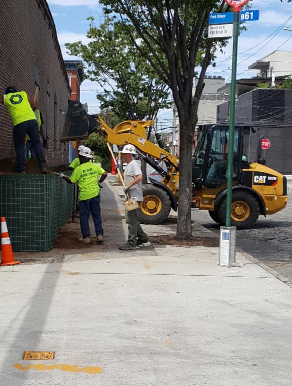
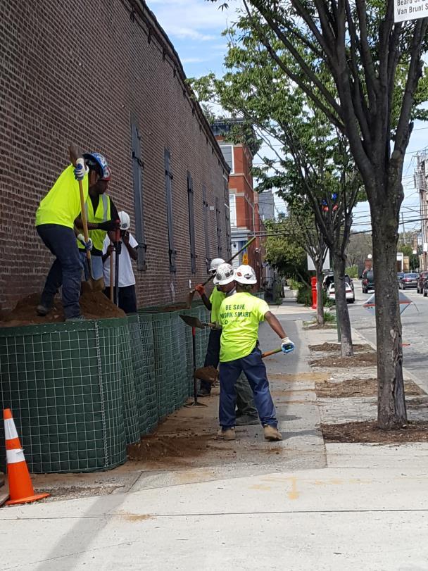
40 Case Study: IFPM Red Hook Installation August 2017 March 29,


41 Case Study: IFPM Red Hook Completed Pre-deployed Installation Note: Barriers were painted to protect against UV damage and increase longevity March 29,

42 Case Study: IFPM Red Hook Beautification Project Designs were solicited and 11 were chosen by a panel of local stakeholders for installation. Installation will be completed in April The artist whose work is shown below is a 9 year old Red Hook Resident. March 29,

43 Conover Street/Reed Street Existing 43

44 Conover Street/Reed Street Pre-Storm Conditions 44
45 Beard Street Existing 45

46 Beard Street Blue Sky Conditions 46

47 Beard Street Pre-Storm Conditions 47
48 INTERIM TO PERMANENT MITIGATION RED HOOK INTEGRATED FLOOD PROTECTION SYSTEM 48


49 Red Hook Neighborhood Profile Historic waterfront community in Brooklyn, NY with a long history of shipping and industry. Home to the City s second largest public housing project. Experiencing increasing pressures of gentrification. The neighborhood is geographically separated from the rest of Brooklyn. It has little access to public transportation and limited local services and amenities. The community suffered a devastating crime wave and disinvestment in 1960s early 2000s after much of the port jobs left the City. 49


50 Red Hook Hurricane Sandy caused extensive damage in the neighborhood. The entire neighborhood is very lowlying and a large potion of the land is former marsh. Sandy caused up to five feet of flooding. The Red Hook Houses lost power, heat, and water for weeks. Local schools were flooded and closed. Local businesses closed for weeks and months. A large volunteer recovery effort formed, and local residents were very active in emergency recovery and long term resiliency planning. 50

51 Red Hook Red Hook is extremely vulnerable to flooding. 51


52 Red Hook Red Hook is extremely vulnerable to flooding. This map shows the inundation and flood depth that occurred during Hurricane Sandy within the Red Hook study area Major inland portions of Red Hook had between 2-4 feet of water during Hurricane Sandy Hurricane Sandy flooding was similar to a 1% Annual Chance Storm Event (also referred to as a 100-Year Storm) which has 1 % chance of occurring in a given year 52
53 Red Hook Red Hook is extremely vulnerable to flooding. The Red Hook Study Area consists of 597 acres, 1,448 buildings, and a population of 13,402 that are potentially vulnerable to flooding. Nearly the entire peninsula is at risk to coastal flooding. Storm Event Area Flooded % of Total Acres Study Area Affected Buildings No. of % of Buildings Total Affected Population % of Population Total Hurricane Sandy % % 10,560 85% 10 year 92 15% % 820 7% 10 year +2.5' SLR % % 7,802 63% 50 year % % 9,118 74% 50 year +2.5' SLR % 1,067 74% 10,780 87% 100 year % 1,033 71% 10,650 86% 100 year +2.5' SLR % 1,236 85% 11,080 89% 53

54 Red Hook Characteristics and Vulnerabilities 54
")

55 Red Hook Side Note - NYCHA FEMA Recovery and Resiliency Project The Federal Emergency Management Agency allocated over $438 million to the New York City Housing Authority (NYCHA) Red Hook Houses for Hurricane Sandy. Covers 31 of 32 NYCHA buildings and includes a variety of recovery and resiliency work. Seventy percent of Red Hook residents live in the Red Hook Houses. 55
56 PROJECT OVERVIEW 56
57 Red Hook Integrated Flood Protection System Project Funding $4 million in FEMA Advanced Assistance Funding For the Feasibility Study $50 million in FEMA Funding from New York State $50 million in New York City Capital Funding $104 million for Study, Design and Construction 57

58 Red Hook Integrated Flood Protection System NYC has submitted the feasibility study for FEMA review. FEMA HMGP AA Process Feasibility Study To advance to design, the City must first identify a preferred feasible/implementable project and submit that preferred project to FEMA for review and approval. Design If that preferred project is approved by FEMA, FEMA releases funding to begin the design phase. Construction If the design is approved by FEMA, FEMA releases funding for construction. 58
59 Red Hook Integrated Flood Protection System Feasibility Study Objectives and Goals Feasibility Study Objectives: A broader understanding of what comprehensive resiliency in Red Hook means. Identify a $100m project for coastal flood risk reduction that is moved into design, environmental review, permitting, and construction. Identify other feasible options for future flood risk reduction in Red Hook. City Goals for Coastal Flood Risk Reduction in Red Hook: Reduce Red Hook s coastal flood risk with minimal impact on the neighborhood when there isn t a storm. Build a flood protection system that is tailored to Red Hook and its unique waterfront. Incorporate community and stakeholder priorities and identify additional project goals. Identify a project for the FEMA HMGP application. 59
60 Red Hook Integrated Flood Protection System Community Outreach and Engagement Community Goals Integration with the community and streets to allow for pedestrian and vehicle traffic flow. Don t just build a wall. Maintain and improve maritime capacity and waterfront access. Consider drainage issues, include upgrades to sewer system. Provide jobs and job training for local residents. The system should actually work. There is less concern with heights and locations. Enhance bike-friendly environment, including the Brooklyn Greenway. Coordinate and keep informed of other major projects in the neighborhood. Keep the community engaged and informed. Continue to focus on storm preparedness. 60
61 PROJECT ANALYSIS 61

62 Red Hook Integrated Flood Protection System Feasibility Considerations FEMA-approved IFPS: Must have independent utility cannot depend on other separate projects or features to fully function Cannot have a negative impact on existing conditions or worsen flooding in other nearby locations The quantified benefits must be greater than the quantified costs Must be permanent - no temporary measures such as sandbags 62

63 Red Hook Integrated Flood Protection System Analysis Connecting the high points and segmenting the project. Segmenting or phasing the project was first analyzed to provide an easier implementation path. Achieving independent utility is extremely challenging or impossible, given the topography and floodplain in Red Hook The natural high points are indicated by the white circles and connected by the white dotted lines 63

64 Red Hook Integrated Flood Protection System Analysis The project team analyzed a variety of alignments. Given the inability to segment the project, the following three potential alignment scenarios were developed: The Outermost Alignment: Generally follows waterfront edge and includes greatest amount of area within IFPS. Potentially most expensive scenario. Highest DFE. Impacts to the working waterfront and to views. The In-Between Alignment: Moderate flood risk reduction benefits within the study area. Takes advantage of the natural topographic high points reducing the overall length of the system. The Innermost Alignment: Least area of protection and length. Potentially lowest cost scenario. NOTE - Portions of these alignments can be mixed and matched. 64
 scenarios.")
 + 2.5 Sea Level Rise + 6 of Freeboard. DFE D: equivalent to the 1% annual chance flood (100-year storm) + 2.")
65 Red Hook Integrated Flood Protection System Analysis The project team analyzed a variety of DFEs. The coastal flood risk/vulnerability for various storm conditions were used as a starting guide to develop four Design Flood Elevation (DFE) scenarios. Beard and Richards DFE A: equivalent to the 10% annual chance flood (10-year storm) + 1 Sea Level Rise DFE B: equivalent to the 10% annual chance flood (10-year storm) Sea Level Rise + 6 of Freeboard Clinton Wharf DFE C: equivalent to the 2% annual chance flood (50-year storm) Sea Level Rise + 6 of Freeboard. DFE D: equivalent to the 1% annual chance flood (100-year storm) Sea Level Rise + 1 of Freeboard. 65
66 Red Hook Integrated Flood Protection System Analysis Each DFE presents significant challenges and did not meet project goals and objectives. To achieve independent utility the project would have to essentially encircle the entire peninsula of Red Hook. Given the length of the alignments needed to tie into high ground at the DFEs analyzed, these IFPS options would have significant negative impacts to existing drainage patterns and require major drainage modifications such as new pumps. The system can potentially create a bath tub within the barrier if walls were over-topped or during a heavy rain storm if the pumps failed or volume of water exceeded the capacity of the pumps. The system effectively created a barrier to the waterfront and did not provide additional community design benefits. The number of deployables also posed a serious challenge to the integrity of the system. 66
67 PROPOSED PROJECT 67


68 Red Hook Integrated Flood Protection System Each DFE presents significant challenges and did not meet project goals and objectives. Given the complications with a large-scale deployable system integrated flood protection system, the project decided to lower the level of protection to the point where deployables were not necessary. This level is 8 feet NAVD88, equivalent to the 10-Year Coastal Storm Surge + 1 feet of sea level rise. This approach reduced the length of the project to the two lowest points in Red Hook Atlantic Basin and a portion of Beard Street. Atlantic Basin Beard Street 68

69 Red Hook Integrated Flood Protection System Proposed Project Areas Proposed project will reduce flood risks from a 10 year storm + 1 SLR. Interventions at Atlantic Basin and Beard Street Completely passive solution NYCHA Allows for future adaptability at Beard Street Minimal negative impacts 69

70 Red Hook Integrated Flood Protection System Beard Street Buried floodwall with raised roadway and sidewalks Passive solution Future adaptability Minimal impacts to views and circulation 70

71 Red Hook Integrated Flood Protection System Atlantic Basin Replace existing bulkhead New landscaped walkway No deployables Minimal impacts to views and circulation Requires re-grading 71
72 Red Hook Integrated Flood Protection System Proposed Project Advantages Achieve independent utility Passive and permanent solution No significant or negative impacts to drainage with some drainage modifications Stronger foundation allows for future adaptation at Beard St Does not inhibit other long-term planning considerations Maintain access to the waterfront Planned improved design at two waterfront locations. 72
73 QUESTIONS? Heather Roiter Director of Hazard Mitigation Melissa Umberger Deputy Director of Hazard Mitigation Jessica Colon Senior Policy Advisor, Planning Mayor s Office of Recovery and Resiliency jicolon@cityhall.nyc.gov 73
Climate Change Impacts and Adaptation for Coastal Transport Infrastructure in the Caribbean
 UNCTAD Regional Workshop 5 7 December 2017, Bridgetown, Barbados Climate Change Impacts and Adaptation for Coastal Transport Infrastructure in the Caribbean Identifying operational thresholds for vulnerability
PLEASE do not reuse without permission from NYCDEP. [Please notify Pinar Balci and Alan Cohn
 PLEASE do not reuse without permission from NYCDEP. [Please notify Pinar Balci (PBalci@dep.nyc.gov) and Alan Cohn (AlanC@dep.nyc.gov) if you intend to use any of these slides, and indicate where and when
BOROUGH OF HIGHLANDS STRATEGIC RECOVERY PLANNING REPORT. September 2014
 BOROUGH OF HIGHLANDS September 2014 Why do a Strategic Recovery Planning Report? (SRPR) To access state $$ for plans/ordinance re-writing To assist in decision-making To educate about risks & vulnerability
Storm Preparedness & Hazard Mitigation for Post-Sandy Red Hook, Brooklyn, NY Deborah Mills, CFM Dewberry Consultants, LLC.
 Storm Preparedness & Hazard Mitigation for Post-Sandy Red Hook, Brooklyn, NY Deborah Mills, CFM Dewberry Consultants, LLC. Agenda Introduction to the Project Red Hook, Brooklyn Sandy s Impact Hazard Risks
Resilient Water and Wastewater Systems
 Resilient Water and Wastewater Systems June 2017 Ryan Berni Deputy Mayor City of New Orleans Patrick Schultz Principal & General Manager, Resource Optimization Veolia New Orleans A challenging delta landscape
TREASURE COAST REGIONAL PLANNING COUNCIL M E M O R A N D U M. To: Council Members AGENDA ITEM 3E
 TREASURE COAST REGIONAL PLANNING COUNCIL M E M O R A N D U M To: Council Members AGENDA ITEM 3E From: Date: Subject: Staff May 19, 2017 Council Meeting Local Government Comprehensive Plan Review Draft
Lessons [being] learnt 2016 Flood in Cedar Rapids. Sandy Pumphrey Project Engineer II Flood Mitigation
![Lessons [being] learnt 2016 Flood in Cedar Rapids. Sandy Pumphrey Project Engineer II Flood Mitigation](/thumbs/77/74998790.jpg "Lessons [being] learnt 2016 Flood in Cedar Rapids. Sandy Pumphrey Project Engineer II Flood Mitigation") Lessons [being] learnt 2016 Flood in Cedar Rapids Sandy Pumphrey Project Engineer II Flood Mitigation 319 286 5363 s.pumphrey@cedar-rapids.org Agenda 2008 Flood Event 2016 Flood Event [Long Term] Flood
Lessons [being] learnt 2016 Flood in Cedar Rapids Sandy Pumphrey Project Engineer II Flood Mitigation 319 286 5363 s.pumphrey@cedar-rapids.org Agenda 2008 Flood Event 2016 Flood Event [Long Term] Flood
FEMA s National Risk Index
 FEMA s National Risk Index Agenda National Risk Index (NRI) Background NRI Working Groups Calculating and NRI Hazard Data Resilience Score Social Vulnerability and Resilience Data Built Environment Data
ENHANCING RESILIENCE IN BOSTON A Guide for Large Buildings and Institutions. Boston Green Tourism May 21, 2015
 ENHANCING RESILIENCE IN BOSTON A Guide for Large Buildings and Institutions Boston Green Tourism May 21, 2015 Report Context Climate Action Plan Action-Item GRC Preparedness Recommendations ABC Priority
The newly updated and comprehensive SWMP shall:
 RFQ SCOPE OF SERVICES 2.1 Project Purpose The City of Miami, ( City ) is seeking professional engineering services from a qualified firm for the purpose of planning and developing a newly updated and comprehensive
Long term planning for NJ Coastal Resiliency: Coastal Flood Exposure Assessment and Salt Marsh Migration under future sea level rise
 Long term planning for NJ Coastal Resiliency: Coastal Flood Exposure Assessment and Salt Marsh Migration under future sea level rise Richard Lathrop, Lisa Auermuller, Jeanne Herb, Marjorie Kaplan, James
Transit Cooperative Research Program TCRP A-41: Improving the Resilience of Transit Agencies Threatened by Natural Disasters
 Transit Cooperative Research Program TCRP A-41: Improving the Resilience of Transit Agencies Threatened by Natural Disasters APTA 2016 Multimodal Operations Workshop Calgary, Alberta Presentation Overview»
Adapting to Rising Tides
 Adapting to Rising Tides A regional program that uses findings, processes, tools and relationships built by ART and its partners to lead and support efforts that increase the resilience of San Francisco
Miami-Dade Water & Sewer Department. Miami-Dade Water and Sewer Department 1
 Miami-Dade Water & Sewer Department Miami-Dade Water and Sewer Department www.miamidade.gov/water 1 Miami-Dade Water and Sewer Department (WASD) Largest Water & Sewer Utility in the Southeastern United
SURREY COASTAL FLOOD ADAPTATION STRATEGY (CFAS) Improving Coastal Flood Adaptation Approaches (ICFAA) Stakeholder Workshop
 Improving Coastal Flood Adaptation Approaches (ICFAA) Stakeholder Workshop") SURREY COASTAL FLOOD ADAPTATION STRATEGY (CFAS) Improving Coastal Flood Adaptation Approaches (ICFAA) Stakeholder Workshop Workshop Introductions and Opening Remarks Our objectives for the day To explore
SURREY COASTAL FLOOD ADAPTATION STRATEGY (CFAS) Improving Coastal Flood Adaptation Approaches (ICFAA) Stakeholder Workshop Workshop Introductions and Opening Remarks Our objectives for the day To explore
Hazard Mitigation as an Economic Development Strategy
 Hazard Mitigation as an Economic Development Strategy Linking Water Infrastructure to Community and Economic Development in Smaller Places October 29, 2014 About Us Sustainable Communities Capacity Building
America s Climate Choices Adaptation A Challenge to the Transportation Industry
 America s Climate Choices Adaptation A Challenge to the Transportation Industry November 3, 2010 TRB Webinar H. G. Schwartz, Jr. 1 Major Factors Affecting Climate 2 MITIGATION Measures to reduce Greenhouse
CHNEP/SWFRPC Climate Ready Programs
 CHNEP/SWFRPC Climate Ready Programs Southwest Florida is currently experiencing climate change. The natural setting of southwest Florida coupled with extensive overinvestment in the areas closest to the
Adaptation: Advising Local Governments on Climate Change Vulnerability
 Local Government Commission Building Livable Communities Ahwahnee Hotel Adaptation: Advising Local Governments on Climate Change Vulnerability March 12, 2009 2 Planning for Climate Vulnerability Exec.
Atlantic Coast of New York East Rockaway Inlet to Rockaway Inlet and Jamaica Bay, NY
 Atlantic Coast of New York East Rockaway Inlet to Rockaway Inlet and Jamaica Bay, NY Draft Reformulation Public Information October 2016 US Army Corps of Engineers Presentation Outline Project Overview
Adaptation to Extreme Weather Events and Climate Change
 Office of Planning, Environment and Realty Office of Infrastructure Adaptation to Extreme Weather Events and Climate Change SASHTO Meeting Robert Kafalenos, FHWA August 25, 2014 1 Planning for the Future
(1) Bridge, Road and Railway (Adaptation Project) (2) Bridge, Road and Railway (BAU Development with Adaptation Options)
 Bridge, Road and Railway (Adaptation Project) (2) Bridge, Road and Railway (BAU Development with Adaptation Options)") Sub-sector Guideline: (1) Bridge, Road and Railway (Adaptation Project) (2) Bridge, Road and Railway (BAU Development with Adaptation Options) Basic Concept A. General Concept Climate change will increase
Sub-sector Guideline: (1) Bridge, Road and Railway (Adaptation Project) (2) Bridge, Road and Railway (BAU Development with Adaptation Options) Basic Concept A. General Concept Climate change will increase
FEMA P-1019 Emergency Power Systems for Critical Facilities. ASFPM May 4, 2017 David K Low, PE DK Low & Associates
 FEMA P-1019 Emergency Power Systems for Critical Facilities ASFPM May 4, 2017 David K Low, PE DK Low & Associates FEMA P-1019 FEMA P-1019 A critical facility that is fully compliant with the minimum building
CLIMATE CHANGE ADAPTATION IN MASSACHUSETTS
 CLIMATE CHANGE ADAPTATION IN MASSACHUSETTS Kathleen Baskin, Director of Water Policy June 3, 2013 MA Global Warming Solutions Act of 2008 Mitigation Reduce greenhouse gas emissions below 1990 levels by
High Performance and Durability of Commercial Construction
 Future-Proofing Your Buildings for High Performance and Durability High Performance and Durability of Commercial Construction Chuck Miccolis Vice President, Commercial Lines Insurance Institute for Business
Flooded Bus Barns and Buckled Rails: Public Transportation and Climate Change Adaptation
 Flooded Bus Barns and Buckled Rails: Public Transportation and Climate Change Adaptation Tina Hodges Federal Transit Administration September 22, 2011 Tina.Hodges@dot.gov 1 Key Themes Proactive instead
Vulnerabilities to Climate Change Impacts and Strengthening Disaster Risk Management in East Asian Cities
 2008 Primer Reducing Vulnerabilities to Climate Change Impacts and Strengthening Disaster Risk Management in East Asian Cities I/ CITY DESCRIPTION New York City comprises five boroughs, each of which is
Smart and Resilient Cities. Stefan Denig, Center of Competence Cities, London
 Smart and Resilient Cities Stefan Denig, Center of Competence Cities, London siemens.com/answers Why Resilience? The number of natural disasters is increasing Hazard Page 2 Why Resilience? The costs of
Sea Level Rise Adaptation Strategy for San Diego Bay. Brian Holland, AICP, Climate Program Manager City of San Diego EESTF June 29, 2011
 Sea Level Rise Adaptation Strategy for San Diego Bay Brian Holland, AICP, Climate Program Manager City of San Diego EESTF June 29, 2011 Five Milestones for Climate Adaptation Adapted from Preparing for
Cooper, Robertson & Partners Architecture, Urban Design. Flood Mitigation in
 Cooper, Robertson & Partners Architecture, Urban Design Flood Mitigation in Page Museum 1 Design Flood Mitigation in Museum Design COOPER ROBERTSON The devastating effects of Hurricane Sandy on New York
Climate Change Adaptation Strategies for Infrastructure Managers
 Climate Change Adaptation Strategies for Infrastructure Managers Green Streets and Highways Conference November 17, 2010 Butch Wlaschin Office of Asset Management Federal Highway Administration U.S. Department
ACKNOWLEDGEMENTS. Sincerely, Executive Director and Staff. Rockingham Planning Commission. 156 Water Street Exeter, NH (603)
") ACKNOWLEDGEMENTS The gratefully acknowledges the participation of coastal New Hampshire municipalities in the preparation of this report: City of Portsmouth Town of New Castle Town of Rye Town of North
ACKNOWLEDGEMENTS The gratefully acknowledges the participation of coastal New Hampshire municipalities in the preparation of this report: City of Portsmouth Town of New Castle Town of Rye Town of North
CHAPTER 7. San Dieguito River Flooding Adaptation
 CHAPTER 7 San Dieguito River Flooding Adaptation This chapter includes a range of adaptation measures to address vulnerabilities from flooding along the San Dieguito River, including the river valley,
A State Policy Framework for Adaptation to Climate Change
 A State Policy Framework for Adaptation to Climate Change James Murley, Director Barry N. Heimlich Nick Bollman* Center for Urban and Environmental Solutions at Florida Atlantic University *In Memoriam
By Sea, And by Air. Port Administration and Legal Issues Seminar. Brenda L. Enos, CHMM, REM Massachusetts Port Authority April 11, 2013
 By Sea, And by Air. Port Administration and Legal Issues Seminar Brenda L. Enos, CHMM, REM Massachusetts Port Authority April 11, 2013 1 OVERVIEW Basics of Climate Change What are we doing about it A Bit
FEMA s Mitigation Support for Resiliency: Innovative Drought and Flood Mitigation Projects
 FEMA s Mitigation Support for Resiliency: Innovative Drought and Flood Mitigation Projects Jordan Williams, CFM Eric Kenney, PE, CFM May 4, 2017 2 Hazard Mitigation Purpose: Research climate resilient
Vulnerability Assessment
 Brief coastal vulnerability assessment for the City of Cocoa Beach, conducted utilizing available NOAA and UF GeoPlan tools. Vulnerability Assessment City of Cocoa Beach East Central Florida Regional Planning
The Northern Waterfront Seawall History and Earthquake Performance Waterfront Plan Working Group Meeting April 13, 2016
 The Northern Waterfront Seawall History and Earthquake Performance Waterfront Plan Working Group Meeting April 13, 2016 Steven Reel, PE - Project Manager, Engineering Division, Port 1 The Northern Waterfront
Codifying Resiliency
 Codifying Resiliency LEED s new resiliency pilot credits Living Cities Forum, Halifax September 12, 2016 Ryan Zizzo Technical Director MASc, PEng, LEED AP ND $ Billion Economic Impacts Catastrophic Insurable
Hurricane. Table Top Exercise SMHC 9/16/2015. Tuesday, September 15, 15
 Hurricane Table Top Exercise SMHC 9/16/2015 Scenario TTX rules Scenario Timeline Goals and Scope Break Injects, discussion Scenario Hurricane Fred has come ashore in coastal Maine Wind gusts of over 80MPH
U.S. Army Corps of Engineers Broward County Planning Assistance to States. Flood Risk Management Study for Tidally Influenced Coastal Areas
 U.S. Army Corps of Engineers Broward County Planning Assistance to States Flood Risk Management Study for Tidally Influenced Coastal Areas Initial Stakeholder Resiliency Meeting Wednesday, November 9,
Challenge 2: Community Resilience in Dania Beach
 University of New Orleans ScholarWorks@UNO Coastal Resilience Workshop Coastal Resilience Workshop 2015 Oct 27th, 1:00 PM - 1:15 PM Challenge 2: Community Resilience in Dania Beach Samantha Danchuk Environmental
Click to edit title style
 Click to edit title style Samuel B. Merrill, PhD Judy Gates November 16, 2015 Click to edit Master text styles Second level Third level Fourth level» Fifth level Integrating Storm Surge and Sea Level Rise
Appendix D - Evaluation of Interim Solutions
 Appendix D - Evaluation of Interim Solutions D.1 Introduction The implementation of long-term improvements is projected to take 5 to 8 years. To reduce the number of years of flooding impacts, the partner
Creating a Resilient Community. The City of Satellite Beach Community Resiliency Project
 Creating a Resilient Community The City of Satellite Beach Community Resiliency Project Resources www.climate.gov www.climate.nasa.gov Agenda Creating A Resilient Community Project Overview Resiliency
Town of Canmore. Climate Change Adaptation Background Report and Resilience Plan
 Town of Canmore Climate Change Adaptation Background Report and Resilience Plan PRAC Webinar Tools for Municipal Adaptation Action May 4 th, 2018 Lori Rissling Wynn Sustainability Coordinator/Development
PRINCESS ANNE DISTRICT STORMWATER PROJECTS
 PRINCESS ANNE DISTRICT STORMWATER PROJECTS Topics o o o o o Sea Level Rise and the Southern Watersheds Ashville Park Sherwood Lakes Kingston Estates Drainage Operations & Maintenance in the Southern Watersheds
SFPUC Flooding Workshop Tuesday, February 9, 2016
 Presenters: SFPUC Flooding Workshop Tuesday, February 9, 2016 Tommy Moala, Assistant General Manager, Wastewater Enterprise Stefani Harrison, Project Manager Photo: Dec 3, 2014 End of Cayuga Street 25-year
Port of Manzanillo. Port of Manzanillo: Climate Risks and Opportunities. IAIA Symposium: Sustainable Mega- Infrastructure and Impact Assessment
 Port of Manzanillo Port of Manzanillo: Climate Risks and Opportunities IAIA Symposium: Sustainable Mega- Infrastructure and Impact Assessment Panama City, December 3, 2015 Vladimir Stenek, IFC, World Bank
Local Flood Hazard Mitigation Program. A framework for hazard mitigation in the NYC West of Hudson Water Supply Watersheds
 Local Flood Hazard Mitigation Program A framework for hazard mitigation in the NYC West of Hudson Water Supply Watersheds Flood Hazard Mitigation Defined 2 2 Presentation Overview Why and how is the NYC
Keeping the Lights On: Energy Facility Flood Mitigation Projects in New England Takeaways for Protecting Critical Assets and Infrastructure
 Keeping the Lights On: Energy Facility Flood Mitigation Projects in New England Takeaways for Protecting Critical Assets and Infrastructure Proactive By Design. Our Company Commitment Presented by: Gary
U.S. Energy Sector Vulnerabilities to Climate Change and Extreme Weather
 U.S. Energy Sector Vulnerabilities to Climate Change and Extreme Weather NASEO 2013 Annual Meeting September 17, 2013 Jonathan Pershing, Ph.D. Deputy Assistant Secretary for Climate Change Policy and Technology,
Increasing the Coastal Resilience of Vulnerable Wastewater Infrastructure on Cape Cod and the Islands Two Case Studies
 Increasing the Coastal Resilience of Vulnerable Wastewater Infrastructure on Cape Cod and the Islands Two Case Studies Anastasia Rudenko GHD Marc Drainville GHD Guy Campinha Town of Wareham, MA June 2017
COASTAL RESILIENCE SYMPOSIUM Mathijs van Ledden & Maarten Kluyver (Haskoning Inc.)
") HURRICANE RISK REDUCTION PROGRAM NEW ORLEANS STRUCTURAL SOLUTIONS AND RESILIENCE Mathijs van Ledden Royal Haskoning COASTAL RESILIENCE SYMPOSIUM Mathijs van Ledden & Maarten Kluyver (Haskoning Inc.) HOUSTON
HURRICANE RISK REDUCTION PROGRAM NEW ORLEANS STRUCTURAL SOLUTIONS AND RESILIENCE Mathijs van Ledden Royal Haskoning COASTAL RESILIENCE SYMPOSIUM Mathijs van Ledden & Maarten Kluyver (Haskoning Inc.) HOUSTON
Adapting Road Infrastructure to Climate Extremes and Change
 Adapting Road Infrastructure to Climate Extremes and Change Experience from Small Pacific Island States September 2015 Pacific Island Countries (PICs) - - geographically dispersed, remote with small populations
Developing Evaluation Criteria
 ART SUPPLY: HOW-TO GUIDE Design Your Project Step 7: Evaluate Responses Developing Evaluation Criteria ADAPTING TO RISING TIDES PROGRAM This guide helps with Developing and using a set of criteria for
MECKLENBURG COUNTY HAZARD MITIGATION PLAN
 MECKLENBURG COUNTY HAZARD MITIGATION PLAN 2010 Plan Update Adopted By: Mecklenburg County City of Charlotte Town of Cornelius Town of Davidson Town of Huntersville Town of Matthews Town of Mint Hill Town
Disaster Damage Prevention Planning
 News and Press Disaster Damage Prevention Planning September 6, 2017 Solid waste infrastructure, including buildings, plants, machinery and vehicles are critical to keeping a municipality functioning after
A Salt Marsh Advancement Zone Assessment of West Haven, Connecticut
 A Salt Marsh Advancement Zone Assessment of West Haven, Connecticut Front cover image: Open space and unprotected parcels critical to the conservation of marsh advancement corridors in West Haven; from
SAFETY AND NOISE 9. Safety and Noise
 SAFETY AND NOISE 9 9 Safety and Noise Safety is a basic human need and is required for a community to thrive. The goals and policies in this element are designed to protect and enhance public health and
Mitigation Plan Mission, Goals and Action Items
 Section 4: Mitigation Plan Mission, Goals and Action Items Introduction... 2 Mission... 2 Mitigation Plan Goals... 2 Natural Hazard Mitigation Plan Action Items... 3 Coordinating Organization... 4 Partner
Climate Change Resiliency Program
 Climate Change Resiliency Program Presentation to FMCB March 20, 2017 Winter of 2015 -- Winter Resiliency Winter 2015 revealed very disruptive vulnerabilities in MBTA operations Response to Winter 2015
SECTION 6: MITIGATION STRATEGIES
 SECTION 6: MITIGATION STRATEGIES This section presents mitigation actions for Onondaga County to reduce potential exposure and losses identified as concerns in the Risk Assessment portion of this plan.
Floods of 2008 Urban Systems Wayne Petersen, Urban Conservationist, IDALS. What lessons did we learn? (or should have learned)
") Floods of 2008 Urban Systems Wayne Petersen, Urban Conservationist, IDALS What lessons did we learn? (or should have learned) 100 year storms and 100 year floodplains are not a good standard for the future
Floods of 2008 Urban Systems Wayne Petersen, Urban Conservationist, IDALS What lessons did we learn? (or should have learned) 100 year storms and 100 year floodplains are not a good standard for the future
W. Tobey Ritz MTA Metro-North Railroad, Chief Engineer Capital Engineering New York/New York
 What have we learned about future emergency preparedness from Irene and Sandy W. Tobey Ritz MTA Metro-North Railroad, Chief Engineer Capital Engineering New York/New York Metro North Railroad Storm Surge
3.0 Planning and Submittal Requirements
 October 2003, Revised February 2005 Chapter 3.0, Planning and Submittal Requirements Page 1 3.0 Planning and Submittal Requirements 3.1 Drainage Studies and Drawings The City of Greenwood Village (Village)
Storm Hardening in a Climate Change Context
 Storm Hardening in a Climate Change Context Crédit photo: ConEdison SUMMARY Some of the strategies we have adopted post- Hurricane Sandy are examples of permanent adaptation to a fundamentally different
Houston-Galveston Area Regional Hazard Mitigation Plan. Initial Planning Workshop
 Houston-Galveston Area Regional Hazard Mitigation Plan Initial Planning Workshop Overview Project Approach Hazard Identification and Risk Assessment Capability Assessment Policy Development and Project
Climate Change in Myanmar Process and Prioritizing Adaptation at the Local Level
 National Adaption Plan 2017 Asia Expo JW Marriott Dongdaemun Square Seoul, Korea September 11 12, Climate Change in Myanmar Process and Prioritizing Adaptation at the Local Level Min Maw Director, Pollution
CITY OF MOUNTAIN VIEW
 CITY OF MOUNTAIN VIEW Incorporate Climate Change Adaptation in Municipal Scale, Urban Watershed Planning at the City of Mountain View Raymond Wong, PhD, PE, LEED AP Lisa Au, PE Floodplain Management Association
IV. ENVIRONMENTAL IMPACT ANALYSIS G. HYDROLOGY/WATER QUALITY
 IV. ENVIRONMENTAL IMPACT ANALYSIS G. HYDROLOGY/WATER QUALITY ENVIRONMENTAL SETTING The project site is located in the Wilshire community of the City of Los Angeles and is bound by S. Wetherly Drive to
7. NATURAL HAZARDS 7.1 SECTION INTRODUCTION
 7. NATURAL HAZARDS 7.1 SECTION INTRODUCTION 7.1.1 The Resource Management Act empowers Council to control any actual or potential effects of the use, development, or protection of land for the purpose
Natural Hazards Mitigation Plan Kankakee County, Illinois Executive Summary
 1. Introduction Natural Hazards Mitigation Plan Kankakee County, Illinois Executive Summary Kankakee County s first Natural Hazards Mitigation Plan was adopted by the Kankakee County Board on October 11,
Dam Safety Modifications at Cherokee, Fort Loudoun, Tellico, and Watts Bar. SUMMARY: This notice is provided in accordance with the Council on
 This document is scheduled to be published in the Federal Register on 08/29/2013 and available online at http://federalregister.gov/a/2013-21134, and on FDsys.gov BILLING CODE 8120-08-P TENNESSEE VALLEY
Superstorm Sandy The Experience of The Port Authority of New York and New Jersey
 Superstorm Sandy The Experience of The Port Authority of New York and New Jersey December 7, 2012 American Association of Port Authorities 2012 - Year of Disruptions Port Authority of NY & NJ Responsible
Climate and Disaster Risk Screening Report for Energy Project in Nepal: Hypothetical Energy Project 1
 Climate and Disaster Risk Screening Report for Energy Project in Nepal: Hypothetical Energy Project 1 1 This is the output report from applying the World Bank Group's Climate and Disaster Risk Screening
Preparing for Tomorrow s High Tide: Source Water Implications of Sea Level Rise in Delaware
 Preparing for Tomorrow s High Tide: Source Water Implications of Sea Level Rise in Delaware Susan E. Love, Planner IV Delaware Coastal Programs Presentation for the Source Water Assessment and Protection
National Disaster Resilience Competition (NDRC)
") National Disaster Resilience Competition (NDRC) Building Resilient Energy Systems July 30, 2015 U.S. Department of Housing and Urban Development 1 Disclaimer This presentation is intended to provide communities
National Disaster Resilience Competition (NDRC) Building Resilient Energy Systems July 30, 2015 U.S. Department of Housing and Urban Development 1 Disclaimer This presentation is intended to provide communities
Sarah White, MEMA. https://resilientma.com/
 Sarah White, MEMA https://resilientma.com/ Background and Framework Code of Federal Regulations Title 44, Chapter 1, Part 201 ( 201.4: State Hazard Mitigation Plans) Disaster Mitigation Act of 2000 (DMA2000)
Flood Risk Management on the Elwha: Case Study of the Federal Levee Modification Project
 Flood Risk Management on the Elwha: Case Study of the Federal Levee Modification Project US Army Corps of Engineers Zac Corum, PE, Hydraulic Engineer Travis Ball, PE, CFM, Hydraulic Engineer Seattle District
How to Navigate Stormy Weather:
 2013 COMMERCIAL SERIES How to Navigate Stormy Weather: EMERGENCY PREPAREDNESS AND RESPONSE PLANNING MANY BUSINESSES ARE NOT PREPARED TO RESPOND TO A MAN-MADE OR NATURAL DISASTER. STATISTICS SHOW THAT,
Kilbirnie Town Centre Plan Working Paper. Assessing the implications of sea level rise Kilbirnie Town Centre
 Kilbirnie Town Centre Plan Working Paper Assessing the implications of sea level rise Kilbirnie Town Centre September 2009 1 Contents 1. Introduction... 3 2. Objectives of the Study... 3 3. Methodology
Climate Change Adaptation Tools and Barriers in Newfoundland and Labrador
 Climate Change Adaptation Tools and Barriers in Newfoundland and Labrador Liveable Cities Forum 2016 Halifax, NS 12-September-2016 The Project NL Office of Climate Change and Energy Efficiency (CCEE) lead
SOUTHEAST FLORIDA REGIONAL COMPACT CLIMATE CHANGE. Sustainable Communities & Transportation Planning
 SOUTHEAST FLORIDA REGIONAL COMPACT CLIMATE CHANGE Draft Regional Climate Action Plan Sustainable Communities & Transportation Planning SP-1 Develop criteria in collaboration with municipal and county planning
INTRODUCTION. NOS Priorities Roadmap, p. 3
 INTRODUCTION In the United States, almost 40 percent of the population lives in coastal shoreline counties. These counties contribute $6.6 trillion, or just under half of the country s gross domestic product,
Climate Change Adaptation Strategy Summary & Roadmap. SUMMARY & ROADMAP DRAFT
 www.geelongaustralia.com.au CLIMATE CHANGE ADAPTATION STRATEGY SUMMARY & ROADMAP Climate Change Adaptation Strategy Summary & Roadmap DRAFT FOR PUBLIC CONSULTATION to read our full strategy, also see the
New York City Housing Authority Sandy Recovery Program
 New York City Housing Authority Sandy Recovery Program About the Authority MISSION Increasing opportunities for low- and moderateincome New Yorkers by providing safe, affordable housing and facilitating
Community Disaster Resilience
 Community Disaster Resilience Overview Disaster Management Cycle Community Disaster Resilience Hands on Approach for Increasing Community Disaster Resilience Addressing Weaknesses Planning for the Future
Memorandum. FROM: Jim Ortbal Rosalynn Hughey Barry Ng TO: HONORABLE MAYOR, CITY COUNCIL. DATE: June 16, 2017
 CITY OF SANjOSE CAPITAL OF SILICON VALLEY TO: HONORABLE MAYOR, CITY COUNCIL SUBJECT: TRANSPORTATION POLICY UPDATE REQUIRED BY STATE LAW - LOS TO VMT Memorandum FROM: Jim Ortbal Rosalynn Hughey Barry Ng
TOWN OF KILL DEVIL HILLS, NORTH CAROLINA ANNUAL PROGRESS REPORT ON ADOPTED HAZARD MUTIGATION PLAN COMMUNITY #
 TOWN OF KILL DEVIL HILLS, NORTH CAROLINA ANNUAL PROGRESS REPORT ON ADOPTED HAZARD MUTIGATION PLAN COMMUNITY # 375353 Since the last application for continued participation in the Community Rating System
Hampton Roads Climate Impact Quantification Initiative
 David Arthur Chief Energy Analysis and Sustainability The Volpe Center, USDOT Hampton Roads Climate Impact Quantification Initiative Task 1 Briefing Transportation Technical Advisory Committee (TTAC) Hampton
SECTION 6: MITIGATION STRATEGY
 SECTION 6: MITIGATION STRATEGY This section describes the process by which the Lehigh Valley Steering Committee and municipal planning partnership performed the update to the county and local mitigation
PRIORITY AXIS 1: A well connected region
 PRIORITY AXIS 1: A well connected region Corresponds to Thematic objective 7- promoting sustainable transport and removing bottlenecks in key network infrastructures All data presented is published for
PLANNED UNIT DEVELOPMENT, PLANNING APPROVAL & SUBDIVISION STAFF REPORT Date: June 4, 2015
 PLANNED UNIT DEVELOPMENT, PLANNING APPROVAL & SUBDIVISION STAFF REPORT Date: June 4, 2015 NAME SUBDIVISION NAME CC Williams Plant Subdivision CC Williams Plant Subdivision LOCATION CITY COUNCIL DISTRICT
Coalitions and Green Pledges
 Sustainability Actions Recently Taken Passed a Resolution on Sustainability Appointed a citizens' green committee Established an internal green task force Adopted a sustainability plan Updated existing
City of Cambridge Climate Change Vulnerability Assessment and Adaptation Plan
 City of Cambridge Climate Change Vulnerability Assessment and Adaptation Plan September 11, 2013 John Bolduc, Environmental Planner Project Manager, City of Cambridge Nathalie Beauvais, Int'l Assoc. AIA,