I-710 Corridor Project EIR/EIS Engineering/Environmental Component Statement of Work RFP No. PS ISSUED:
|
|
|
- Stella Cunningham
- 5 years ago
- Views:
Transcription


1 Los Angeles County Metropolitan Transportation Authority I-710 Corridor Project EIR/EIS Engineering/Environmental Component Statement of Work RFP No. PS ISSUED:
2 Name: Interstate 710 Corridor Project (Ports to State Route 60) Period of Performance: May 11, 2007 to December 28, 2010 Total Cost: ($XXXXX.XX) Fiscal Year: Charge District and EA: K Fed/State Split: ($xxxx,xx Federal; $xxxx,xx State) Fund Source: 232 WBS Codes: 100, 160, 165, 175, 180, 205, 235, 255 LACMTA Project Manager Ernest T. Morales LACMTA Contract Manager: Mark Penn LACMTA Project Administrator Adrian Alvarez Department Project Manager: Sharas Bangalore Department Assistant Project: Manager Simon Au Department Design Manager: Mario Gutierrez Consultant Project Manager: TBD ii
3 PREFACE... viii I. GENERAL DESCRIPTION OF SCOPE OF WORK...10 A) INTRODUCTION...10 II. SCOPE OF WORK TASK DETAILS PERFORM PROJECT MANAGEMENT (APPLIES TO ALL 2 WORK ELEMENTS) PROJECT MANAGEMENT Component Execution and Control PERFORM PRELIMINARY ENGINEERING STUDIES AND PREPARE DRAFT ENGINEERING PROJECT REPORT (WORK ELEMENT NO. 2) COORDINATION WITH I-5 ENVIRONMENTAL DOCUMENT COMMUNITY PARTICIPATION COORDINATION PUBLIC OFFICIALS AND STAFF OVERSIGHT COORDINATION REVIEW AND UPDATE PROJECT INFORMATION Review Approved PID and Initial Project Alternatives: Obtain and Review Existing Geotechnical Information Obtain and Review Existing Materials Information Review Traffic Data and Forecasts Review Previous Geometrics Review and Update Project Cost Estimate PERFORM ENGINEERING STUDIES Prepare Geometric Plans for Project Alternatives and Construction Staging and Engineering Analysis Base Mapping Perform Value Analysis Perform Hydraulics/Hydrology Studies Develop Highway Planting Design Concepts Perform Traffic Operational Analysis Review and Update Right-of-Way Data Sheet Assess Utility Impacts Perform Railroad Goods Movement Study Coordinate Truck Weight/Enforcement Facilities Analysis Alternative Goods Movement Technology Analysis Perform Relinquishment and Vacation Study Coordinate Traffic Studies with Environmental Consultant (for existing freeway and arterial highway and for proposed improvements to freeway and arterial highways) Prepare/Update Materials Information for Engineering Project Report Prepare Structures Advanced Planning Studies Prepare HOV Report PREPARE DRAFT ENGINEERING PROJECT REPORT Prepare Cost Estimates for Alternatives, with reduced plans Prepare Fact Sheet for Exceptions to Design Standards Obtain Approval for Exceptions to Encroachment Policy...49
4 iv Prepare Draft Engineering Project Report Circulate, Review, & Approve Draft Engineering Project Report COORDINATION WITH I-5 ENVIRONMENTAL DOCUMENTS COMMUNITY PARTICIPATION COORDINATION SERVICES PUBLIC OFFICALS AND STAFF OVERSIGHT COORDINATION PERFORM ENVIRONMENTAL SCOPING AND SELECT ALTERNATIVES FOR STUDY Review Project Information Perform Public and Agency Scoping and Community Outreach Process Select Alternatives for Further Study (Assist the Project Team) (coordinate with Sections and ) Prepare Maps for Environmental Evaluation PERFORM GENERAL ENVIRONMENTAL STUDIES Perform Multimodal Review Perform Traffic Studies Perform Initial Feasibility Analysis Perform Surveys And GIS Mapping For Environmental Studies (Assist The Project Team In The Process) Geometric Plans Coordination Obtain Right of Entry for Environmental Studies Perform Community Impact Analysis, Land Use and Growth Studies Perform Visual Impact Analysis and scenic resource evaluation Perform Noise Study Perform Air Quality Study and Health Risk Assessment Perform Water Quality and Storm Water Runoff Studies Perform Utilities & Emergency /Community Service Study Perform Energy Studies Prepare Summary of Geotechnical Report Perform Preliminary Site Investigation for Hazardous Waste Prepare Draft Right of Way Relocation Impact Document Prepare Location Hydraulic/Floodplain Report Coordinate Los Angeles River Impact Studies Perform Paleontology Studies BIOLOGICAL STUDIES Prepare Biological Assessment Prepare Wetlands and Other Waters of the United States Studies Resource Agency Permit Related Coordination Prepare Natural Environment Study Report CULTURAL RESOURCE STUDIES Conduct Archaeological Survey Prepare Area of Potential Effects (APE) Perform Historical Records and Literature Search Perform Historical, Architectural and Archaeological Resource Studies PREAPRE DRAFT ENVIRONMENTAL DOCUMENT (DED)...77
5 Conduct Environmental Quality Control and Other Reviews Obtain Approval to Circulate (assist the Project Team in the process) Perform Environmental Coordination PREPARE SECTION 4(F) EVALUATION CIRCULATE DRAFT ENVIRONMENTAL DOCUMENT AND SELECTED PREFERRED PROJECT ALTERNATIVE (WORK ELEMENT NO. 1) CIRCULATE DRAFT ENVIRONMENTAL DOCUMENT (DED) Prepare Master Distribution and Invitation Lists Prepare Notices Regarding Public Hearing(s) &Availability of DED Publish And Circulate DED (Assist the Department) PREPARE FOR AND HOLD PUBLIC MEETINGS Determine Need for Public Hearing Process Arrange for Public Hearing Logistics Prepare Displays for Public Hearing Prepare Second Notices of Public Hearing and Availability of DED Hold Public Hearings...83 Includes all remaining activities relating to holding the public hearing Prepare and Distribute Record of Public Hearing RESPOND TO PUBLIC COMMENTS AND CORRESPONDENCE SELECT PREFERRED ALTERNATIVE (ASSIST THE PROJECT TEAM) PREPARE AND APPROVE ENGINEERING PROJECT REPORT (Work Element No. 2) REVIEW AND APPROVE ENGINEERING PROJECT REPORT Update Draft Engineering Project Report Approved Engineering Project Report Updated Storm Water Data Sheet PREPARE AND APPROVE FINAL ENVIRONMENTAL DOCUMENT (FED) (WORK ELEMENT NO.1) Circulate For Review (QA/QC) (Department Task) Revisions Due To Review Comments (QA/QC) Finalize Section 4(F) Evaluation Findings Statement of Overriding Concerns CEQA Certification FHWA Approval Section 106 Consultation and MOA Section 7 Consultation Final Section 4(f) Statement Floodplain Only Practicable Alternative Wetlands Only Practicable Alternative Finding Public Distribution of FED (Assist the Project Team) Response To Comments on the FED Prepare Final Right Of Way Relocation Impact Document...90
6 COMPLETE ENVIRONMENTAL DOCUMENT (Work Element No. 1) ROD (NEPA) Prepare and File Notice of Determination (CEQA) Environmental Commitments Record (ECR)...91 III. PERIOD OF PERFORMANCE...92 IV. SCHEDULE...92 V. REPORTS...93 VI. MEETINGS...93 VII. MATERIALS SUPPLIED BY MTA...94 VIII. PERSONNEL...94 IX. FOR THE MTA...94 vi
7 LIST OF FIGURES Figure No. Description 1 Project Study Area & Traffic Impact Analysis Area 2 I-710 Project Governance Structure LIST OF TABLES Table No. Description 1 Major Arterial Highways included in Study Area 2 Gateway Cities Truck Impacted Intersection Improvements (Phase I and II). APPENDICES Appendix A B Description Hybrid Design Concept Facilitation of Community Participation Scope of Work
8 PREFACE An Environmental Impact Report (EIR)/Environmental Impact Statement (EIS) (Environmental Studies) will be prepared along with a Project Report (Engineering) for the I-710 Corridor Project (Project). The technical studies associated with these documents will be accomplished in two work elements as follows: Work Element 1 Environmental Studies (EIR/EIS) Work Element 2 Engineering (Project Report) Work Elements 1 and 2 (Environmental Studies and Engineering) are included together in one RFP. However, firms can choose to submit proposals for these two work elements as follows: 1. Proposal for Work Element 1 (Environmental Studies) (Sections 100, 165, 175, and ) 2. Proposal for Work Element 2 (Engineering) (Sections 100, 160, ) 3. Proposal for Work Elements 1 and 2 together (all Sections of the RFP) All proposals are to completely address and include all the sections listed above for each of the work elements and all other sections of the RFP. The proposals will be evaluated separately using the selected criteria. Interviews will be held with the highest total ranking proposers following review of the proposals for all three proposal categories. Following the interviews, the agency will either award contracts for each of the first two categories listed above separately or a single contract for category 3 (both work elements together). For category 3, the proposals will be evaluated for both work elements together without bifurcation of the proposers. Firms can choose to submit in more than one proposal category for Work Elements 1 and 2 without prejudice from the agency. To minimize multiple submittals, any proposal for Work Elements 1 and 2 together, shall provide clarifying language in their submittal that states the following: A. This submittal is only for combined Work Elements 1 & 2 and team firms should not be considered separately. OR B. This submittal can be considered for both Work Elements together, and also can be evaluated independently for selection of either Work Elements 1 or 2. As set forth in Section of the RFP for EIR/EIS, entitled Community Participation Coordination, the firms that submit proposals on Work Elements 1 and 2 of the RFP for EIR/EIS will be required to include community participation coordination services in their proposal. As set forth in Section , this activity is for all coordination efforts to support the Community Participation Program. Coordination Services does not mean hiring a community relations subconsultant to perform that work; rather, it specifically means the viii
9 following activities to coordinate technical efforts with the independent consultant who will be delivering the Community Participation Program, as set forth in Section : 1) Provision of all material to be reviewed with the community groups 2) Introductory meeting with Community Participation Program Consultant and ongoing coordination meetings with the Project Team 3) Review, comment, and respond to community input, which input will be supplied by the Community Participation Consultant. 4) At least one presentation to each of the advisory or working groups listed in Appendix B. If, for whatever reason, a firm submitting on Work Elements 1 and 2 nonetheless chooses to include a community relations consultant firm in its proposal, that community relations firm and any subconsultants will not be eligible to perform Facilitation of Community Participation and will be eliminated from any further consideration when proposals are being reviewed. These firms will be notified accordingly. The Community Participation contract and consultant(s) (and any subconsultants) will be independent of and without any contractual connections to the consultants for the technical Work Elements 1 and 2 above.
10 I. GENERAL DESCRIPTION OF SCOPE OF WORK A) INTRODUCTION The purpose of this Scope of Work is the preparation of a comprehensive joint engineering Project Report and environmental impact report/environmental impact statement (EIR/EIS or I-710 Environmental Document) for the I-710 Corridor Project (Project), prepared and processed in accordance with both the California Environmental Quality Act (CEQA) and the National Environmental Policy Act (NEPA). A Section 4(f) analysis will be required should it be determined that the project will impact public park or recreation lands, wildlife or waterfowl, or historic sites. This Scope of Work includes preparation of the EIR/EIS, an engineering Project Report and performance of all tasks related thereto, including preparation of necessary technical studies, plans, production of draft and final EIR/EIS text, Project Report text, coordination of review by responsible and trustee public agencies, preparation of responses to comments, and participation and coordination within the Community Participation Process. The Scope of Work also includes preparation of a mitigation monitoring and reporting plan (MMRP), a draft and final relocation plan, and other associated tasks described further below. Staff of the Los Angeles County Metropolitan Transportation Authority (MTA) will be directing a community outreach effort, and coordinating with Caltrans to develop an engineering Project Report to support the environmental clearance of the EIR/EIS. MTA is the Contract Manager and will be responsible for managing the overall EIR/EIS and engineering Project Report terms and conditions. To accomplish this MTA will be assisted by a Caltrans Deputy Project Manager for Environmental, a Caltrans Deputy Project Manager for Engineering, and an MTA Director of Constituent Program Management (Project Manager for Community Participation). The lead agency for CEQA purposes will be Caltrans and the lead agency for NEPA purposes will be the FHWA, provided that the FHWA may later transfer to Caltrans the role of NEPA lead agency. The selected Consultant(s) to perform this Scope of Work will assist the MTA in preparation of the Environmental Document and engineering Project Report as outlined herein. MTA staff will be involved in the review of the EIR/EIS and engineering Project Report, community outreach and related tasks, with support and consultation from other agencies, as necessary. A project team (Project Team) consisting of Caltrans, Gateway Cities Council of Governments (GCCOG), MTA and the Southern California Association of Governments (SCAG), will assist and guide the MTA Project Manager in conducting this study. A project committee (Project Committee); an executive committee (Executive Committee) comprised of the MTA, GCCOG, SCAG, County of Los Angeles, Project Committee Co-Chairs, the Port of Long Beach, the Port of Los Angeles, and Caltrans; and a Technical Advisory Committee (TAC) will also be involved in the review process. (See Figure 2). In addition, staff from Caltrans will be responsible for completion of specific tasks in preparation of the EIR/EIS and engineering Project Report, as described in Part II below. Part I of this Scope of Work provides a general outline of the scope of services to be carried out by the Consultant(s). Further specifications and guidance on the items to include in the EIR/EIS and engineering Project Report and associated tasks are provided at (Caltrans Standard Requirements) and at (Environmental Process Documentation). Part II of this Scope of 10
11 Work also provides additional specifications and guidance on particular tasks. In addition, Part II provides a preliminary work schedule. This preliminary schedule is subject to change, but reflects the current expectations of MTA & Caltrans. Proposals should acknowledge these expectations, and suggest changes or refinements as appropriate. Other services and innovative ideas the Consultant(s) believe may be appropriate or necessary for the successful completion of the EIR/EIS and engineering Project Report should be identified in the Proposal, but described and listed as proposed additional services along with a separate itemization of the costs for each additional task. Proposals should include suggestions of any additional reports, evaluations, or plans needed under applicable laws and regulations prior to approval of the Project, together with a proposed budget for preparation of these additional reports, evaluations, and plans. The MTA as Contract Manager reserves the right to negotiate with the selected Consultant(s) on the final work plan and schedule. Project Area The proposed project area includes the I-710 freeway from Ocean Blvd. to the SR-60 freeway (See Figure 1). The north end of the proposed project area includes the northbound and southbound connectors between I-710 and SR-60. The current proposed limit along the I-710 freeway for the project area is approximately 18 miles in length. The project also includes freeway-to-freeway interchanges between the I-710 freeway with the I-405, SR-91, I-105 and I-5. The current proposed project limits for the freeway-to-freeway interchange are 1 mile east and west of I-710 for these adjoining freeways for geometric studies. The proposed project area also currently includes the major arterial north/south and east/west highways (see Table 1) from Wilmington Ave. on the west to Lakewood Blvd. on the east. The project termini are subject to review and refinement during the course of this Scope of Work, as described further in Part II below. Figure 1 also shows a larger area designated as the traffic impact analysis area. Improvements to the I-710 freeway may potentially change truck trips on these other freeways included within the boundaries of this traffic impact analysis area. The potential significant impacts of the I-710 improvements on other freeways within the traffic impact analysis area need to be assessed, analyzed, and reported as part of the traffic model for the I-710 EIR/EIS. However, environmental analysis and mitigation measures for these other freeways beyond the limits specified in the marked traffic impact analysis are not included. The north end of the proposed project area includes the I-5 freeway and SR-60. Caltrans along with the I-5 Consortium Cities Joint Powers Authority (I-5 JPA) (jointly, Caltrans I-5 Project Team) is preparing an Environmental Document to improve I-5 from the I-605 to north of I-710. The I-5 proposed project area overlaps with the I-710 proposed project area. Therefore, the I-710 Environmental Document will include analysis of the portion of the I-5 proposed project that overlaps with and is required for the north end of the I-710 project. This includes the following: 1. Geometric Plans 11
12 I-710 Washington Blvd to SR-60 freeway including all local interchange from and including the Washington Blvd Interchange. I-5/I-710 Interchange I-710/SR-60 Interchange 2. Traffic modeling and forecast for the north end of study area 3. Air quality and other environmental studies for the north end of study area 4. Community coordination with City of Commerce for Washington Blvd. Interchange north on I-710 and any community coordination with the community of East Los Angeles The Caltrans I-5 Project Team currently expects to have draft engineering and environmental studies of the I-5/I-710 Interchange available before similar studies for this area are commenced by the I-710 Project Team. The I-710 Project Team Consultants will be responsible for reviewing the Caltrans I-5 Project Team work products and providing all additional work to make the engineering and environmental studies provided consistent with the I-710 studies south of the I-5/I-710 Interchange. Caltrans and the I-710 Consultant(s) will share data with the I-5 JPA in order to incorporate all data, information, and studies into each others document while both documents are being prepared. However, the study area for the I-5 Environmental Document and engineering Project Report will terminate at the I-710 interchange where coordination will begin and be provided between both efforts. This coordination will be ongoing, continue throughout both efforts and include meetings, sharing of drafts of all studies, plans and data and final documents. The I-5 JPA is not responsible for the work on the north end of the I-710 project area (Washington Blvd. to SR-60). This will be the responsibility of Caltrans and the I-710 Consultant(s). Purpose and Need for the Project The Interstate 710 (I-710) corridor in the project area described above (I-710 Corridor) is considered one of the nations most heavily traveled freeway routes. It is also considered a major trucking corridor for the transport of goods. Based on an examination of existing and future travel conditions, the I-710 Corridor is already experiencing travel performance problems due to congestion and accidents, which will only worsen over time. A large number of trucks use the I-710 to travel between the Ports of Los Angeles and Long Beach and rail freight yards located near Interstate 5 (I-5), and to warehousing and distribution points scattered throughout the Southern California area. At the south end of the I-710 trucks comprise over 20 percent of the traffic stream all day, compared with an average daily truck traffic percentage of 6 to 13 percent on similar freeways in Los Angeles County. It is 12
13 not uncommon to see a line of trucks queue, nose to tail, in the two right-hand lanes of the freeway, which greatly restricts movement across lanes as other vehicles attempt to merge onto or exit the freeway. The second factor affecting travel performance is traffic accidents. The safety concern is attributed to the high I-710 traffic volumes (based on the existing number of lanes), existing design deficiencies, freeway congestion, and the interaction between cars and trucks in the traffic stream. Field Officers from the California Highway Patrol and Caltrans Traffic Accident Surveillance and Analysis System (TASAS) data indicate that the I-710 has one of the highest accident rates in the Los Angeles County region. TASAS data indicates that an average of five truck-related accidents occur on I-710 each day, well above the statewide average when compared to similar freeway facilities. Truck accidents are extremely problematic. On numerous occasions truck related accidents form bottlenecks as emergency vehicles clear a scene. Furthermore, secondary accidents occur when travel lanes have to be closed as vehicles approach an unexpected queue and accident site. The I-710 freeway (the proposed project area) was built in the 1950 s. Other than in the vicinity of its interchange with I-105, I-710 has not undergone any major improvements since then. Currently the freeway is being repaved and a concrete safety barrier is being installed in the median to replace the existing metal beam guard-rail. The only other improvements have been a few local interchange ramp modifications such as at the Firestone Blvd. interchange. The purpose and need rationale will also incorporate community air quality and health issues resulting from congestion along the I-710 Corridor. A primary goal of any improvement alternative is the reduction of air pollutants. At the south end of the freeway there are only six lanes (three in each direction). The rest of the freeway consists mostly of eight lanes (four in each direction). In addition to the inadequate number of lanes, most of the existing local interchanges do not have modern design features, resulting in additional congestion and accidents. Project Background and Prior Studies Certain studies on the I-710 Corridor, listed below, have already been completed. The Consultant is to use the listed studies for initial guidance and input when preparing the EIR/EIS, as follows: a) The Tier 2 Community Advisory Committee (CAC) Report In a participatory and expanded outreach effort that commenced in June 2003, MTA provided facilitators to assist corridor communities with the formation and implementation of a two-tiered CAC process. In tandem with this effort, the Gateway Cities Council of Governments (GCCOG) retained an engineer to work directly with the Tier 1 CACs and local city public works staff to identify community level freeway engineering design issues and solutions toward the development of a Locally Preferred Strategy. The Tier 1 CACs consisted of local community members from highly impacted neighborhoods appointed by their respective City Councils. Six cities and the unincorporated area of East Los Angeles (where appointments were made by the County Supervisor) formed Tier 1 Committees. 13
14 The City of Long Beach developed its own public involvement and engineering process to reach consensus on a freeway design within their city limits, and this work was integrated with the work of the rest of the Corridor. The Tier 2 CAC represented a broad base of interests, including representatives from local communities, academia, environmental, labor, health, air quality, economic and environmental justice interests. Each Tier 1 CAC selected its own representative to Tier 2. The charge of the Tier 2 Committee was to: (1) review key local issues and opportunities identified by the Tier 1 CAC s, (2) consider issues of local and regional importance from a corridor-wide perspective, and (3) provide recommendations to the I-710 Oversight Policy Committee for a comprehensive transportation solution for the I-710 Corridor. The Tier 2 CAC met over the course of approximately one year and developed a report of issues, concerns, conditions and recommendations for improving the I-710 freeway and the Corridor entitled I-710 Major Corridor Study: Major Opportunity/Strategy Recommendations and Conditions, more commonly referred to as the Tier 2 CAC Report. The report is included in the MCS and may also be viewed at This input was instrumental in developing a consensus on the I-710 Locally Preferred Strategy (LPS), called the Hybrid design. The LPS that emerged from this process dramatically reduces property acquisition compared with the previously studied alternatives; improves safety by separating truck traffic from automobiles; and reduces emissions by improving operating truck speeds. As directed by the MTA Board and the I-710 Oversight Policy Committee, the Tier 2 CAC Report is to be used as pre-scoping guidance in the preparation of the I-710 EIR/EIS. b) 2005 I-710 Major Corridor Study A Major Corridor Study (MCS) was completed for the I-710 freeway in The MCS was approved and adopted by the I-710 Oversight Policy Committee and the MTA Board of Directors. An electronic copy of the MCS can be obtained by visiting The Major Corridor Study Compliance Report documents how the proposed improvements to the I-710 complies with the Intermodal Surface Transportation Efficiency Act of 1991 (ISTEA) requirements and MCS guidance, and is consistent with the I-710 Corridor MCS proposed project objectives. As part of the MCS, conceptual alternatives were developed for the I-710 Corridor. The I-710 Corridor MCS No-Build and Transportation Systems Management/Transportation Demand Management (TSM/TDM) Alternatives include a number of freeway improvement alternatives and other transportation alternatives. In addition, a locally preferred strategy (LPS), called the Hybrid design, was also adopted in The Hybrid design includes a full standard 10-lane mixed-flow, at-grade facility next to 4-truck lanes, separated from the 10-mixed flow lanes (total of 14 lanes) (see Appendix A). The truck lanes are mostly at-grade. Finally, the Hybrid design includes a separate study of the I-5/I-710 interchange to address the concerns of two communities (Commerce and East LA) that border it. c) I-5/I-710 Interchange Mini-Study The East Los Angeles I-5/I-710 Mini-Study Draft Report ( Alternative Analysis for the I-5/I- 710 Interchange ) was completed in September The study was initiated at the request of 14
15 East Los Angeles and the City of Commerce Tier 1 CACs to address specific freeway design issues. The Mini-Study recommends design improvements that reduce the right-of-way requirements compared to the original design. The greatest benefits will be in the area near the on/off ramps around Olympic Boulevard and along Telegraph Road north of Atlantic Boulevard. In addition, the Mini-Study concludes that the use of an elevated HOV lane on the I-5 will reduce the cross section of the freeway and result in less right-of-way requirements. This issue will be addressed by the I-5 EIR/EIS between the I-605 and the I-710 which will be conducted by I-5 JPA in the summer of The City of Commerce City Council approved its Tier 1 recommendation on April 4, 2006, and the East Los Angeles Tier 1 CAC completed its review and submitted comments on April 6, The study results, as well as the comments and findings of the Tier 1 CAC s have been incorporated into the I-710 LPS by the I-710 Oversight Policy Committee on April 27, 2006, and adopted by the MTA Board June 22, d) Coordination with Other Projects The I-710 project study area as currently configured in Figure 1 encompasses a large area. Any proposed improvements to I-710 in the general project area will have to be consistent with, comply with, or coordinate with other transportation projects and plans within or in the vicinity of the I-710 proposed project area. These include but may not be limited to the following: Gerald Desmond Bridge Replacement I-405 Freeway Improvements SR-91/I-605/I-405 Feasibility Study (in progress) SR-47 Expressway Los Angeles County Department of Public Works: Signal Synchronization Projects, including: o Atlantic Blvd. o Telegraph Rd. I-105 Gateway Cities Truck Impacted Intersections o Goods Movement NHS Design Access and Implementation I-5 EIR/EIS from I-605 to north of I-710 (in progress) Multi-County Goods Movement Action Plan I-710 PSR (prepared by Caltrans) POLA/POLB ATMIS Project Other studies that are also to be considered in the preparation of the I-710 EIR/EIS include, without limitation, the following: Air Quality Plan (by Gateway Cities and/or AQMD) San Pedro Bay Ports Clean Air Action Plan OCTA/MTA Transportation Coordination Project (in progress) Gateway Cities SR-91/I-605/I-405 Feasibility Study (in progress) 15
16 Resource Materials The following resource materials will be available to and provided to the Consultant(s). June 22, 2006 MTA Board Meeting I-710 South EIR/EIS Board Report, Item 5 (June 14, 2006 Planning and Programming I-710 South EIR/EIS) I-710 MCS Report (2005) I-5/I-710 Alternative Analysis Study (Mini-Study) Gateway Cities Trucking Study LACDPW Signal Synchronization Studies and Plans I-5 EIR/EIS (I-605 to north of I-710) (in progress) (coordination required) Gerald Desmond Bridge Improvement Studies/Plans SR-91/I-605 Needs Assessment Study Air Quality Plan (Gateway Cities or AQMD) (in progress) SCAG s 2004 RTP & 2006 RTIP, regional emission analysis, and other studies and any updates Multi-County Goods Movement Action Plan Port studies for track and rail projections, truck-rail mode splits, O/D studies, truck traffic volumes (including freeways) and infrastructure assessment needs (to be provided by POLA/POLB) POLB and POLA Terminal EIRs and EIS/EIRs (to be provided by the POLA/POLB) Inland Port Feasibility Study Environmental Mitigation for Goods Movement Port and Modal Elasticity Study Phase 2 In addition, the construction of improvements to the I-710 freeway will likely impact adjacent utilities. As part of the Scope of Work, the Consultant will contact the utility companies and request as-built plans from all utilities. Gateway Cities has contacted the utility companies and collected the as-built plans from the following: Tosco/Conoco Phillips Chem Oil Corp Four Corners Pipeline Co. Pipeline System LLC (Pacific Pipeline or Pacific Energy Partners) EPTC Long Beach Water Dept. SCG high pressure gas line Kinder Morgan Petroleum Pipeline L.A. County Sanitation Dept. SCE LADWP Gateway Cities will make these as-built plans and contacts available to the consultant. The consultant will verify the as-builts by contacting the utility companies and requesting up-to-date as-built plans and information. 16
17 Project Oversight and Coordination a) Contract and Project Management The Environmental, Engineering, and Outreach Consultants will be under contract with the Metropolitan Transportation Authority (MTA). MTA s Project Manager will be responsible for managing the overall terms and conditions of the contract. This will include all schedules, deliverables compliance, and direction of the Deputy Project Managers. Any changes in scope of work, time tables, deliverables, etc. will have to be approved by MTA s Project Manager before proceeding. The I-710 EIR/EIS and engineering Project Report will be prepared per guidelines by MTA, Caltrans, and FHWA for EIR/EIS environmental documents and Project Report per the scope of work outlined herein. b) Environmental Document EIR/EIS MTA s Project Manager along with Caltrans Deputy Project Manager for Environmental will be responsible for oversight and approval of the environmental clearance process. Caltrans will be responsible for retaining any additional consultants needed to supplement their staff for their oversight and approval effort. The Environmental Consultant will be required to closely coordinate with Caltrans staff (and their consultants). The schedule to be maintained by the Environmental Consultant will include the scope, meetings, deliverables, etc. for the project report and engineering task. c) Project Report and Engineering Coordination Caltrans Deputy Project Manager for Engineering will be responsible for oversight and approval of the engineering Project Report that accompanies the EIR/EIS. The Environmental Consultant (and their consultants) will be required to closely coordinate with the Engineering Consultant (if different than the Environmental Consultant) and with Caltrans staff (and their consultants). The schedule to be maintained by the Environmental Consultant will include the scope, meetings, deliverables, etc. for the engineering Project Report and engineering task. d) Community Participation Coordination A parallel community participation process will be performed by community participation consultants under separate contract with MTA, and this work will be directed by MTA s Director of Constituent Program Management. The Environmental and Engineering Consultant(s) will coordinate closely with the Community Participation Consultant and provide the necessary materials, support and staff for this coordination. The primary mechanism for coordination will be regularly scheduled internal team meetings among the Project Team, including lead staff from the Community Relations Consultant, the Environmental Consultant, the Engineering Consultant, and staff of the Project Team. The Community Participation Consultant will be required to attend community participation meetings; evaluate all the comments and suggestion from these meeting and provide response materials as subsequently outlined herein. The Environmental and Engineering Consultant(s) shall attend Community Participation meetings at the direction of MTA s Project Manager. 17
18 The Statement of Work for the Facilitation of Community Participation in the I-710 Corridor EIR/EIS is attached as Appendix B, and provides an overview of the EIR/EIS community participation structure, program development and implementation for the I-710 EIR/EIS. As part of the community participation process the Community Participation Consultant will meet with the CACs and other groups and committees shown in that Scope of Work, and demonstrate how community issues and recommendations are being addressed within the scope and context of the I-710 EIR/EIS. The I-710 Project Committee and the Gateway Cities Council of Governments will be responsible for community participation with the CACs for issues and recommendations that may fall outside the scope and context of the EIR/EIS. General Guidelines and Expectations. MTA s Project Manager will be responsible for managing the overall terms and conditions of the contract, directing the Caltrans Deputy Project Managers, and the Consultant(s). The EIR/EIS Consultant, under the direction of the Deputy Project Manager, shall be responsible for developing and maintaining schedules for the entire project as outlined herein, including the other major task (Project Report/Engineering). The Consultant(s) shall verify that all reports have the most up-to-date and accurate project limits, mapping, project description and alternatives description. The Consultant(s) shall be responsible for notifying the Project Manager and Caltrans Deputy Project Managers of any data needed and when it is needed to remain on schedule. The Consultant(s) shall be responsible for identifying and informing the Project Manager and Caltrans Deputy Project Managers of any data/studies necessary for appropriate environmental compliance not identified in the contract or Scope of Work. The Consultant(s) shall identify all necessary approvals and permits. The Consultant(s) shall be responsible for compiling and reviewing all information that may impact the design, project scope, alternatives, and/or schedule. The Consultant(s) will provide, as a standard, two copies of each report or deliverable unless otherwise noted within this Scope of Work. To ensure uniform cost estimates, Part II of this Scope of Work identifies the number of copies expected of each deliverable. However alternative reproduction methods will be considered on a case by case basis. The Consultant(s) shall maintain a complete and organized project file with records of all activities related to the project development process, including but not limited to: meeting minutes, record of conversations, all decisions, field notes, administrative record, etc. 18
19 B. DESCRIPTION OF SCOPE OF SERVICES 1. Prepare Draft EIR/EIS in Accordance with CEQA and NEPA The Consultant will prepare an EIR/EIS that meets the requirements of CEQA and NEPA and associated regulations. An engineering Project Report required to accompany the EIR/EIS will also be prepared. Throughout preparation of the EIR/EIS, the Consultant(s) is expected to provide ongoing consultation to the MTA Project Manager on any additional refinements to this Scope of Work necessary to provide a comprehensive EIR/EIS for the Project in compliance with CEQA and NEPA and other appropriate environmental laws and regulations or as a result of the scoping process, information gathered during the study, community participation process, and the public review and comment process. a) Draft Scoping Report The EIR/EIS Consultant will prepare a draft scoping report based on the results of the scoping meetings and the letters of comment received in response to the NOI/NOP. The scoping report will collate and summarize the comments received and will identify environmental issues and alternatives to be addressed in the EIR/EIS that emerge from the scoping process. One round of revisions to the scoping report will be made based on client and agencies comments and the final scoping report will be prepared. The Consultant(s) will incorporate responses to the NOI/NOP and early public consultation into the Administrative Draft EIR/EIS. b) Purpose and Need The Consultant(s) will provide counsel and support in developing and refining the Purpose and Need statement in compliance with applicable federal and state laws and FHWA and Caltrans guidance. This section should clearly demonstrate that a "need" exists and should define the "need" in terms understandable to the general public. This discussion should clearly describe the problems which the proposed action is to correct. It will form the basis for the "no action" discussion in the "Alternatives" section, and assist with the identification of reasonable alternatives and the selection of the preferred alternative. c) Environmental Setting and Project Description The Consultant(s) will prepare a description of the environmental setting/affected environment and of the project description in accordance with CEQA and NEPA requirements. d) Initial Project Alternatives and Alternative Analysis The Consultant(s), working with the MTA Project Manager and Caltrans Deputy Project Managers, will propose a reasonable range of project alternatives, including the No Build Alternative, for study in the Draft EIR/EIS. The relative merits and disadvantages of the alternatives selected for examination in the Draft EIR/EIS will be assessed and compared, and the preferred alternative will be recommended, by the Project Team. The alternatives analysis in the Draft EIR/EIS, as discussed in the CEQA Guidelines, may be less detailed than the analysis 19
20 of any preferred alternative selected by the CEQA lead agency in consultation with the Project Team. The MCS and Hybrid design resulted from a preliminary set of potential alternatives for the I-710 Corridor. These preliminary alternatives now under consideration are summarized below. The preliminary set of potential alternatives will be the basis of an initial work plan from the Consultant. Nonetheless, this initial list of preliminary alternatives and the initial work plan will be subject to revision in the course of scoping, evaluation of initial feasibility and accompanying feasibility studies, the alternatives analysis process, public hearings, review, and comment. Once project scoping is completed additional alternatives may be analyzed (either on a preliminary basis or through the complete environmental analysis). The Consultant(s) should assume for the purposes of its proposal two additional alternatives to those listed herein, will go through preliminary analysis before the range of alternatives is selected for study in the Draft EIR/EIS, and that any of the preliminary alternatives may be partially or entirely combined with other alternative(s) during the review process. The preliminary analysis of possible alternatives analysis process will screen out options that are not feasible or fail to meet project objectives and may result in modifications or combinations of options described below. The Consultant(s) should assume that up to a total of 4 alternatives will require complete environmental impact analysis in the Draft EIR/EIS and engineering studies. Alternative 1: No Build The No Build (No Action) Alternative consists of those transportation projects that are already planned and committed to be constructed by or before 2035 (subject to additional requirements under CEQA and NEPA). Consequently, Alternative 1 represents future travel conditions in the I-710 Corridor and it is the baseline against which other transportation alternatives proposed for the I-710 Corridor will be assessed. The project list used for this alternative should be based on the 2004 RTP (or most current) Baseline project list. Some of the major projects in the area Alternative 1 would include are the following: Freeway System: I-710 from Ocean Blvd. to I-10, pavement and median rehabilitation, selected bridge widening (no additional capacity) I-5, Orange County line to I mixed flow lanes, 2 HOV lanes SR-91 (County line to I-110) 8-mixed flow lanes, 2 HOV lanes I-110 (POLA to I-10) 8-mixed flow lanes, 4 HOV lanes (north of SR-91) I-10 (I-110 to SR-60) 8-mixed flow lanes I-105 (I-710 to I-605) 6-mixed flow lanes, 2 HOV lanes I-605 (Orange County line to SR-91) 8-mixed flow lanes, 2 HOV lanes I-605 (SR-91 to I-5) 10-mixed flow lanes, 2 HOV lanes I-605 (I-5 to I-10) 8-mixed flow lanes, 2 HOV lanes I-405 (I-110 to I-710) 8-mixed flow lanes and 2 HOV lanes SR-60 (I-710 to I-605) 10-mixed flow lanes SR-60 (I-605 to I-215) 10-mixed flow lanes SR-47, at Ocean Blvd., interchange improvements SR-47/Henry Ford Ave. Extension to Alameda St. 20
21 Implementation of initial Intelligent Transportation System Improvements within the I-710 study area, including POLA/POLB s ATMIS System Roadway System Alameda Street/Henry Ave. - SR-47 ramps to SR-91 ramps widen to six lanes Existing conditions (as defined in SCAG 2007 base mode) New Four-Lane Connector Road to Del Amo Blvd. Avalon Blvd. to Main St. (I-405 freeway) Del Amo Blvd., Main Street to Vermont Ave. widen from two to six lanes Sepulveda Blvd., Alameda St. eastward to the Carson city limits widen from two to four lanes Gerald Desmond Bridge Replacement six lanes Atlantic Blvd., Olympic Blvd. to Whittier Blvd. widen from four lanes to six lanes Phase I (31) and Phase II (45) truck-impacted intersections (see attached list Table 2) Signal System upgrade and Signal Synchronization for major arterials in the I-710 Study area, including: o Telegraph Rd. o Atlantic Blvd. o Del Amo Blvd. o Imperial Hwy. Rail/Transit Alameda Corridor, LA/LB Ports to approximately Washington Blvd. Los Angeles Blue Line downtown Long Beach to 7 th St. / Metro Center in downtown Los Angeles, operational improvements to existing line Los Angeles Eastside Corridor/ Pasadena Gold Line Eastside Extension, Union Station to Pomona/Atlantic in East Los Angeles Green Line, miscellaneous capital and operational improvements to existing line Bus Service Improvements, miscellaneous operational improvements to existing system (approx. 20% increase in service levels) Near dock or on-dock rail yard and line improvements or additions (Ports to supply), accounted for in model trip tables Ports 24-hour terminal operations Alternative 2: Transportation Systems Management/ Transportation Demand Management (TSM/TDM) and Transit Alternative 2 includes Alternative 1 plus operational investments, policies, and actions aimed at improving goods movement, passenger auto and transit travel, and reducing the environmental impacts of transportation for cities and operations in the I-710 study area, including improvements to transit in the corridor. Suggested improvements include the following: I-710 Freeway (Mainline) Additional ramp metering (approximately 8 sites) 21
22 Improved signage on I-710 (added overhead signs, advanced notification) Changeable message signs (at south end of I-710 POLB/POLA ATMIS project) Interchange/Arterials I-710 ramps terminus/arterial improvements Parking restrictions on major parallel arterials during peak periods ** Goods Movement Empty container management through policies and incentives (including virtual container yard, beyond No Build) Expanded drayage truck emission reduction program Implementation of Truck Emission/Safety Enforcement Facilities Transit Additional Blue/Green line bus shuttles Expanded Metrolink service Expanded high speed bus service between Los Angeles and Orange Counties High speed bus service on freeways (e.g., I-605) Enhanced community bus service (e.g. local circulators Long Beach, Norwalk, Montebello, etc) Intelligent Transportation System (ITS) Expanded ITS to include entire study area ** Atlantic Blvd. (PCH to SR-60); Cherry Ave./Garfield Ave. (PCH to SR-60); Eastern Ave. (Cherry Ave. to Atlantic Blvd); Long Beach Blvd. (San Antonio Dr. to Firestone Blvd.) Alternative 3: Goods Movement Enhancement by Rail and/or Advanced Technology Alternative 3 includes all the proposed improvements included for Alternatives 1 through 2 plus an analysis of maximum goods movement by rail. The systems involved include the Alameda Corridor Transportation Corridor and increased (and maximum) rail capacity from the BNSF and UP rail yards in Vernon and Commerce. This alternative also includes expanded or improved on-dock or near-dock rail facilities (existing or contemplated). The Consultant will perform an initial evaluation, before selection of the reasonable range of alternatives to be examined in the Draft EIR/EIS, of the increases and maximum levels of goods movement by rail that is feasible, based on all of (a) the improvements contemplated as part of this alternative, (b) limitations resulting from other existing infrastructure that are not being modified under this proposed alternative, and, separately, (c) the improvements contemplated in Alternatives 1 and 2 as well as this Alternative 3 (Initial Feasibility Analysis). This Initial Feasibility Analysis includes, for example, the potential effects of truck traffic on local arterial highways to some near-dock rail facilities and other inland rail lines and rail yard capacities that would impact maximum goods movement by rail or by track, such as the rail line capacity east of 22
23 the Vernon and Commerce rail yards (called Alameda Corridor East) that could be implemented during the study period. The Initial Feasibility Analysis of Alternative 3 will examine two or three Port cargo volume projections for the horizon year. Development of these volume projections require input from and cooperation with the POLA, POLB, Alameda Corridor Transportation Authority (ACTA), SCAG, as well as BNSF and UP to determine the cargo amounts that can (or could be) moved by rail from the two Ports. Other agencies or groups should also have input. The Ports and ACTA have conducted detailed rail capacity studies (with simulation) to develop on-dock rail, off-dock rail, truck-rail mode splits, and needed infrastructure for the year These mode splits represent maximum utilization of the Ports proposed terminal rail infrastructure and the Alameda Corridor (for unit and possibly shuttle trains). These analyses were used to develop the Ports official vehicular (auto and truck) and train projections for the year 2030 (same as horizon year of 2035). These forecasts also account for 24-hour terminal operation and, thus, extended hours. The Ports and ACTA have transmitted these projections to SCAG for incorporation into its Heavy Duty truck model and 2007 RTP and, also, for modeling in the Multi-County Goods Movement Action Plan. The Ports and ACTA will provide these projections to the MTA Project Manager and the Consultant(s). The projections will include all assumptions used to develop the projections. The Consultant(s) will review the projections and assumptions and submit an evaluation and analysis to MTA, who will then submit to the other agencies for their review and comment in order to accept and verify this information. The two or three cargo volume projections could be changed or modified during the public scoping and Community Participation process. For the purpose of responding to this Scope of Work, if on completion of the Initial Feasibility Analysis and completion of the scoping process it is determined that a different, new cargo volume projection materially different from any of those used in the Initial Feasibility Analysis - would need to be developed or additional alternatives need to be developed to meet any refined capacity objectives, then this additional work would be subject to evaluation and negotiation of a change order. In addition, the Initial Feasibility Analysis will include a general screening level discussion of the relative congestion and related concerns associated with cargo volume increases during the study period in particular areas and in particular forms (e.g., truck v. rail v. alternative technology if feasible). This discussion will be for preliminary screening purposes only, primarily (a) to assist in evaluating, with respect to Alternatives 2 and 3, their respective feasibility, ability to meet project objectives, and ability to reduce environmental impacts at the threshold level needed to qualify under CEQA and NEPA as an appropriate build alternative for detailed study in the EIR/EIS; and (b) to assist in refining any project capacity objectives and project and alternative descriptions during the scoping process. The Initial Feasibility Analysis will not require formal full detailed analysis of all significant environmental impacts meeting CEQA and NEPA standards for an EIR/EIS. Following review by the Project Team of the Initial Feasibility Analysis, a decision will be made with respect to which Port cargo volume projections will be used for the detailed study of significant adverse environmental impacts required for the Draft EIR/EIS. For the purpose of this Scope of Work, only one port volume figure for the horizon year will be used for detailed environmental study in the EIR/EIS of all of the then-remaining alternatives. 23
24 The Ports of Long Beach and Los Angeles, the MTA Board of Directors, as well as the I-710 Executive Committee have requested that this Scope of Work include study of alternative technologies for moving containers in and out of the Ports using advanced technologies (i.e. nonpolluting). Alternative 3 will therefore include a feasibility analysis of non-polluting alternative goods movement technologies (other than rail or heavy duty truck) that could be used to move container cargo to and from the ports to the Commerce and Vernon rail road yards. Part II contains a detailed scope of work that will be required to complete this alternative technologies feasibility study. This alternative technology study will be conducted prior to the Initial Feasibility Analysis, and both analyses will be conducted and reviewed prior to finalizing the reasonable range of alternatives to be examined in detail in the Draft EIR/EIS Please note: the Initial Feasibility Analysis and alternative technology study described above for Alternative 3 are to be completed and evaluated by the Project Team and the MTA Project Manager before proceeding with final traffic studies and geometric plans or the Draft EIR/EIS. Alternative 4: Arterial Highway & I-710 Congestion Relief Improvements Alternative 4 includes all the improvements or enhancements of Alternatives 1 through 3. Alternatives 1 and 2 include a partial list of arterial highway improvements being considered as part of this Alternative for implementation in the study area. In addition to these listed arterial highway improvements, Alternative 4 includes the maximum arterial highway improvements that could be feasibly implemented in advance of any freeway improvements. The Consultant(s) initial task with respect to this preliminary alternative is to develop and evaluate the maximum additional arterial highway improvements that could be feasibly implemented in advance of any freeway improvements for the Project Team s consideration. This initial task for developing additional improvements proposed to be included as part of Alternative 4 would cover all the major north/south and east/west arterial highways in the study area listed in Table 1. Included in this analysis is also an analysis of all the major arterial highway intersections within the study area. Table 1 lists all of the major arterial highway intersections to be analyzed. This list does not include the intersection improvements to be done as part of the Truck Impacted Intersection improvements shown in Table 2 which are assumed to be in place for this alternative because they are already funded. Alternative 4 also intends to address congestion relief projects on I-710 by identifying existing freeway deficiencies which cause bottlenecks on the freeway, increased (and unnecessary) congestion, and safety problems. These initial congestion relief projects include: (1) Shoemaker Bridge replacement (including modifications to downtown Long Beach ramps (and input to Cesar Chavez park) includes proposed connections to improvements to Gerald Desmond Bridge proposed by the Port of Long Beach (2) PCH and Anaheim Blvd. Interchange Improvements (3) Firestone Blvd. Interchange Improvements (4) Atlantic Blvd./Bandini Blvd. Interchange Improvements 24
25 In addition to the preceding, the Consultant(s) shall work with Caltrans and the local cities to identify and develop other congestion relief improvement projects at the local interchanges (or other freeway locations). These would include, for example, the following: 1. Addition of auxiliary lanes 2. Ramp widening (e. g., Olympic Blvd. and 3 rd St. in East LA) 3. Ramp/Arterial Highway intersection improvements (including street widening) 4. Miscellaneous ramp modifications for local interchanges. During the initial phase of preliminary alternatives review, prior to detailed study in the Draft EIR/EIS, the Consultant(s) will develop and analyze potential congestion relief projects for possible inclusion in Alternative 4 using geometric layouts from the Hybrid design of the locally preferred strategy. The development of these projects will include an analysis of improvement plans that would be consistent with both existing conditions and possible ultimate conditions (Hybrid design). The initial analysis will include identification of existing substandard design, congestion problems, safety issues and problems, and hot-spot air quality analyses etc. that would be required to proceed with these projects in advance of any ultimate improvements. Alternative 5: Ten General Purpose Lane Facility The LPS identified as part of the I-710 Hybrid design that the main-line freeway be improved to include ten general purpose lanes. Based on the LPS (and subsequent SR-91/I-605 Needs Assessment Study), the initial improvements to the general purpose lanes for I-710 are as follows: Alternative: 5A Ten General purpose lanes with no car-pool lanes Alternative: 5B Eight General purpose lanes with one car-pool lane in each direction (total of ten) The LPS Hybrid plan (see Appendix A) shows the ten lanes in Alternative 5A and 5B continuous throughout the length of the project (including through the freeway-to-freeway interchanges). Alternative 6: Alternative 5 with Addition of Four Separated Truck Lanes The final LPS Hybrid design includes ten general purpose lanes next to four separated truck lanes from the ports (Ocean Blvd.) to the rail yards in Commerce and Vernon. The conceptual design for these truck lanes are shown in the figures and typical sections contained in Appendix A. Interchange or ramps from these truck lanes are shown on the figures contained in Appendix A, as outlined in the scope of work. Nonetheless, the Consultant(s) shall perform truck origin/destination studies to determine if the truck interchanges and ramps are adequate and/or whether additional access and egress points from these truck lanes are needed, including identifying the locations for these additional access/egress points (ramps). e) Environmental Impact Analysis After selection of the reasonable range of alternatives to be studied in detail in the Draft EIR/EIS, the Consultant will analyze how the project alternatives could potentially significantly 25
26 affect the environment. This task includes identifying significant environmental impacts. The impact analysis will be comprehensive in scope, covering all CEQA and NEPA requirements. These impacts include, without limitation, those impacts identified in Part II of this Scope of Work, the Caltrans Standard Requirements, and the following topics identified in the CEQA Guidelines: Growth-Inducing Impacts (potential for the project to cause additional population or job growth, housing demand, or cargo diversion from other ports); Significant Environmental Effects of the Proposed Project (including significant unavoidable effects); Significant Irreversible Environmental Changes; Effects Found Not to Be Significant; Consistency with Policies and Regional Plans; Cumulative Impacts. The Consultant will identify significance evaluation criteria for each impact topic, based upon CEQA and NEPA Guidelines. Determinations of actual significance will be made in consultation with the MTA Project Manager and the Caltrans Deputy Project Manager for Environmental. Baselines will be recommended by the Consultant and established by the Project Team prior to commencing detailed environmental impact analyses. The effects of the proposed project will be defined as required under applicable CEQA and NEPA statues and guidelines. The baseline to be used for comparison purposes for the EIS evaluation under NEPA will be different from the baseline used for the EIR evaluation under CEQA, and further modification may be appropriate or necessary for traffic impact analyses, as discussed further in Part II below. The horizon year currently proposed is 2035, subject to further evaluation and consultation with the EIR/EIS Consultant on the appropriate horizon year as part of this Scope of Work. As discussed above, prior to the detailed environmental impact study for the Draft EIR/EIS, the Consultant will complete certain feasibility studies and related preliminary analyses of the preliminary alternatives, in order to assist in refining and selecting the range of alternatives to be studied in detail in the Draft EIR/EIS. Included in these analyses is the Initial Feasibility Analysis. As discussed further above, for the Initial Feasibility Analysis the Consultant will analyze two or three options for goods movement cargo volumes (both Ports combined). The two or three cargo volumes will be determined and potentially changed or modified during the public scoping and Community Participation process. Two or three Port cargo volumes are then to be used to perform a threshold feasibility analysis for Alternatives 1-3. This feasibility analysis will preliminary examine at a screening level, the comparative difference between these two or three projections on the I-710 Corridor under Alternatives 1-3, as described further above. The feasibility analysis will be completed and the range of alternatives to be studied in the Draft EIR/EIS will be determined before proceeding with detailed environmental analyses for the Draft EIR/EIS or detailed engineering studies for any of the alternatives. The Initial Feasibility Analysis will include a matrix to analyze and compare two or three Port cargo volume projections under Alternatives 1-3 (for the projected year). 26
27 The completed Initial Feasibility Analysis will be reviewed with the Project Team and also be reviewed through the Community Participation Program. Following the reviews, a decision will be made by the Project Team on which Port cargo volume projection(s) will be used for more detailed analysis and on the viability of the preliminary Alternatives 2-3 for inclusion in the range of alternatives to be studied in detail in the EIR/EIS. For the purpose of this Scope of Work, only one Port cargo volume figure for the horizon year is planned to be used for more detailed analysis of the final set of alternatives studied in the EIR/EIS. The alternative technology study and Initial Feasibility Analysis are to be completed and reviewed by the Project Team, and the final range of alternatives selected for study in the Draft EIR/EIS, before the Consultant(s) proceeds with any additional analyses or studies, including the Draft EIR/EIS. In addition, these analyses for Alternatives 1, 2, and 3 will be completed and reviewed and approved by the Project Team prior to the Consultant(s) proceeding with any analysis on studies for Alternatives 4 through 7 (or any other alternatives identified from project scoping). Also, as outlined in the Scope of Work, other studies will be completed before proceeding with an in depth analysis and studies required for Alternative 4 through 6. f) Use of Pre-Existing Studies, Models, Projections, and Staff- Prepared Materials A considerable number of technical studies, reports, models, and projections have been previously prepared or developed that will facilitate preparation of the EIR/EIS and engineering Project Report. The Consultant(s) are expected to utilize available and appropriate reference materials, models, and projections where possible and appropriate, in consultation with the MTA Project Manager and Deputy Project Managers. As part of this task, the Consultant(s) also is expected to review, evaluate, and if appropriate update or expand, the previously prepared technical studies and projections identified elsewhere in this Scope of Work, and identify others that might also facilitate preparation of the EIR/EIS and engineering Project Report. Similarly, the Consultant(s) also is expected to evaluate and modify, if appropriate, models and modeling protocols that have been previously developed, including without limitation those listed in Part II below, to the extent that they would facilitate preparation of the EIR/EIS or engineering Project Report for this Project. Part II also identifies particular studies, reports, models and/or projections that the MTA Project Manager and Deputy Project Manager, as opposed to the Consultant, are responsible for preparing (Staff-Prepared Materials). The MTA Project Manager and Deputy Project Managers may request that the Consultant review and comment on draft Staff-Prepared Materials. Once Staff-Prepared Materials are completed and submitted to the Consultant(s) and MTA in final form, the Consultant(s) may rely on them in preparing the Draft EIR/EIS. g) Mitigation Measures and MMRP During impact analysis, the EIR/EIS Consultant will identify practical, feasible mitigation measures to avoid or reduce potentially significant environmental impacts. The EIR/EIS Consultant will evaluate whether mitigation measures would reduce impacts below a level of significance, identify the parties who would be responsible for implementing each measure, and incorporate them into a mitigation monitoring and reporting program (MMRP). The MMRP, 27
28 after review by the MTA Project Manager, is to be proposed for approval at the time the CEQA findings for the final EIR/EIS are adopted by Caltrans. h) Coordination with Responsible Agencies and Trustee Agencies The Consultant(s) will consult and coordinate with and file all necessary documentation with all appropriate governmental agencies at federal, state, regional, and local levels as deemed pertinent to preparation of the EIR/EIS and the engineering Project Report. i) Presentation Format The EIR/EIS Consultant will present the Administrative Draft EIR/EIS and Draft EIR/EIS in a format that: Incorporates responses to the Notice of Preparation and early public consultation; Is understandable to the average lay person; Is organized to allow easy cross-referencing; Summarizes technical data reports and includes the reports in Appendices where appropriate; Organizes discussion of impacts and recommended mitigation measures by topic; Uses maps, graphics, tables, and charts to depict clearly the location and nature of any potentially significant impacts identified in the EIR/EIS, and any other relevant information. Abbreviations will be spelled out in all reports/deliverables submitted. Reports/deliverables will be in English units with Metric in parentheses. In the event Caltrans ceases to require Metric units on Reports/deliverables, MTA will inform the Consultant(s) of this development. Each draft and final edition of the EIR/EIS and any additional technical studies shall be provided in an 8.5 by 11 three-ring binder. All documentation submitted on CD or the equivalent shall be formatted for both Microsoft Word and Adobe Acrobat PDF. There will be an emphasis on providing information visually through the use of maps, graphics, tables, and matrices. j) Project Costs and Funding Options The Consultant(s) shall prepare a fiscal analysis for each project and alternative discussed within the EIR/EIS. The analysis shall include but is not limited to capital costs (including contingency for engineering, construction design, construction oversight, permits) and operation and maintenance costs over a 20 year period. Project Funding Options will be evaluated, including the potential for tolls on certain build alternatives. If the Project Team determines that tolling is a feasible and promising source of revenue, tolling could become one of the additional project alternatives. k) Administrative Draft EIR/EIS and Draft EIR/EIS; Copies 28
29 The Consultant(s) will submit a minimum of 30 bound copies and 30 CDs of the Administrative Draft EIR/EIS and engineering Project Report for the MTA Project Manager to circulate, review, and comment. It is assumed that a first screencheck and second screencheck Administrative Draft EIR/EIS and engineering Project Report will be submitted with two rounds of comments. Based on the comments received on the final screencheck Administrative Draft EIR/EIS and engineering Project Report, the Consultant(s) will prepare the Draft EIR/EIS and engineering Project Report for public review distribution and will submit a final production of 1 bound copy and 1 CD of the Draft EIR/EIS and engineering Project Report to the MTA Project Manager for reproduction and distribution. The Consultant(s) will work with the MTA Project Manager and Deputy Project Manager to prepare a camera-ready Draft EIR/EIS and engineering Project Report for public review. MTA will be responsible for printing and distributing the Draft EIR/EIS and engineering Project Report and will post digital copies on the internet for public review. In addition, the Consultant(s) is responsible for maintaining and providing to the MTA Project Manager, on its request, four hard copies and four electronic copies of any and all studies and reports relied on in the Draft EIR/EIS and engineering Project Report. At the direction of MTA, the Consultant also will set up access to said reference documents and the Draft EIR/EIS and engineering Project Report in local public reading libraries. Community Review, Responses to Comments, Preparation of Administrative Final and Final EIR/EIS and Engineering Project Report, and Adoption a) Public Hearings Following completion of the Draft EIR/EIS, the Consultant(s) will attend the public hearings on the Draft EIR/EIS. If requested by MTA, the Consultant(s) also will assist in development of press releases/community outreach and website postings to provide information to the public regarding the EIR/EIS process, and assist MTA with preparation of notices and transmittal documents as required by CEQA and NEPA. Included in this task is support to MTA for issuance of the ROD and certification of the EIR. This task includes assistance with preparation of staff reports, findings, and exhibits as requested by MTA. b) Response to Comments, Administrative Final EIR/EIS and Final EIR/EIS and Engineering Project Report Following the Draft EIR/EIS review period, the EIR/EIS Consultant will prepare responses to comments and incorporate any necessary changes into an Administrative Final EIR/EIS and engineering Project Report. This work program assumes that the changes needed to respond to public comments will not require recirculation of a revised Draft EIR/EIS. The Consultant will submit a minimum of 30 bound copies and 30 CDs of the Administrative Final EIR/EIS and engineering Project Report for the Project Manager and Deputy Project Managers to circulate, review, and comment. The Proposed Final EIR/EIS and engineering Project Report will be prepared based on the MTA Project Manager and Deputy Project Manager s comments. The Consultant(s) will also make revisions or formulate Errata for the Final EIR/EIS and engineering Project Report as appropriate. The Consultant will submit 1 un-bound camera ready copy and 1 CD of the Final EIR/EIS and engineering Project Report to MTA. 29
30 Caltrans and MTA anticipate a large number of individual comments on the EIR/EIS may be submitted. A single comment letter may contain numerous individual comments. The Consultant(s) will assume the lead role in preparation, assembly, editing, organization and finalizing the responses to comments with support as needed from the MTA Project Manager and Deputy Project Managers. The Consultant(s) will initially organize and number the comments and select topics common to numerous comments that may be considered for thematic responses. Such thematic responses may then be referenced in the responses to common individual comments. Use of the thematic response approach will not, however, fully obviate the need to prepare a specific response to each individual comment. Based on the initial organizational work, meetings will be held with the MTA Project Manager and Deputy Project Managers, legal counsel requested by MTA, and Consultant(s) to review proposed approaches to the thematic and individual responses and to determine assignments. The Consultant(s) will prepare original responses for those comments assigned to the Consultant(s) and will assemble, collate and edit responses prepared by others. Following this process, a complete set of responses will be submitted to the MTA Project Manager for review and comment. Following review and revisions, the Consultant(s) will prepare final responses to comments. c) MMRP, Relocation Plan, and Other Related Plans and Studies The EIR/EIS Consultant will prepare and deliver the proposed MMRP and Draft Relocation Plan for review and comment by the MTA Project Manager as set forth in Part II. The MMRP is to be proposed for approval at the time of the CEQA findings for the final EIR/EIS are adopted by Caltrans. The draft and final Relocation Plan are to be prepared in conformity with the Uniform Relocation Act (including implementing regulations) and, to the extent that they also apply, state and local relocation statutes and regulations. The EIR/EIS Consultant will prepare and deliver additional studies and plans identified in Part II of this Scope of Work or in Caltrans Standard Requirements, according to the schedule provided in and updated from time to time pursuant to this Scope of Work. d) Documentation The Consultant(s) shall maintain a complete and organized project file with records of all activities related to the project development process, including but not limited to: meeting minutes, record of conversations, all decisions, field notes, administrative record, etc. The Consultant(s) also is responsible for storing documents supporting or otherwise related to the EIR/EIS and engineering Project Report that were provided to or reviewed by the Project Manager and Deputy Project Managers, at MTA s direction. The Consultant(s) will deliver two hard copies and an electronic copy of these documents to the Project Manager and Deputy Project Managers at their request. In addition, the Consultant(s) is responsible for maintaining and, on MTA s request, providing up to four hard copies and four electronic copies of any and all studies and reports relied on in any draft or final EIR/EIS and engineering Project Report, and in setting up access to said studies and reports, on request by anyone in the Project Team, for any public reading library or internet-posted library. 30
31 II. SCOPE OF WORK TASK DETAILS 100 PERFORM PROJECT MANAGEMENT (APPLIES TO ALL 2 WORK ELEMENTS) The three work elements are defined as follows: Work Element 1 EIR/EIS Work Element 2 Engineering (Project Report) PROJECT MANAGEMENT The services provided include the initiation, planning, execution, control, and close-out of the Project Approval & Environmental Document (PA&ED) process. An introductory meeting with the Project Team will be held within 15 calendar days after receipt of Notice to Proceed. A schedule showing the Critical Path and Logic Network Schedule, and identification of all project environmental activities and milestones (including engineering and community participation) will be submitted to the Project Team within 30 working days of the introductory meeting from the Environmental Consultant with input and approval of the Consultants of the other two work elements. The Project Team will review and provide comments to the Consultants as soon as possible in order to validate the planning and cost control procedures within the first calendar month of the performance period. This task will include ongoing coordination and communication between the Project Team and the Consultants. Submit a Work Plan for communication management, risk management, and resource management. The Work Plan will detail the scope, project costs, schedule, and milestones. All project deliverables shall be submitted to: Ernest T. Morales Project Manager Los Angeles County Metropolitan Transportation Authority One Gateway Plaza, MS Los Angeles, CA DELIVERABLES Draft Invoices Schedule Work Plan Resource material preliminary review and comments Approvals and permit identification (include in work plan and in schedule) File maintenance Communication and coordination with Project Team and between consultants (letters, memos, minutes, etc.) Update of Project Need and Purpose Coordination of Scopes of Work between consultants 31
32 Component Execution and Control The process of coordinating people and other resources to carry out the plan, and ensuring that all the component objectives are being met by monitoring progress and taking corrective action when necessary. The Consultant(s) shall coordinate monthly Progress Meetings between the Consultant(s) and the Project Team or as required by the Project Team to discuss the work progress, potential problems, plans for the next period, and other progress issues. The Consultant(s), in conjunction with the Project Team will establish the dates and times of these meetings. At least 3 calendar days before each progress meeting, the Consultant(s) shall provide the Project Team with an agenda for the meeting. The Consultant(s) shall prepare meeting minutes and submit them to the Project Team within 7 calendar days after the meeting. The minutes shall indicate issues discussed and the resolution or action required to resolve any issues. At each progress meeting, the Consultant(s) shall submit a four-week horizon schedule to be used in monitoring the progress of the work. Two sets of project files will be maintained: one set on site with each Consultant, and the other set updated monthly and delivered to the MTA Project Manager. The Consultant shall hand over all project files, Geographic Information System (GIS) map files (.mxd,.shp,.dbf, etc.), and the administrative record to the MTA Project Manager at the completion of the project. DELIVERABLES Project invoices Progress reports Agendas and minutes for monthly progress meetings. Project schedule updates 32
33 160 PERFORM PRELIMINARY ENGINEERING STUDIES AND PREPARE DRAFT ENGINEERING PROJECT REPORT (WORK ELEMENT NO. 2) Conduct conceptual and preliminary engineering studies used in the development of a draft and final Environmental Document and engineering Project Report COORDINATION WITH I-5 ENVIRONMENTAL DOCUMENT This activity is for all coordination efforts and in cooperation of all information, data, studies (draft and final) from the I-710 Environmental Document and engineering Project Report. As outlined in Section I this will be an ongoing effort to incorporate the document and all information into the I-5 Environmental Document. Likewise any applicable information will be included from the I-5 Environmental Document into the I-710 documents. Meetings will be held throughout the preparation of both the I-710 and I-5 documents to assume close coordination throughout and incorporation of results from one document into the other COMMUNITY PARTICIPATION COORDINATION The Scope of Work for Community Participation is a separate RFP included in Appendix B. Environmental and Engineering Consultant(s) activity is for all coordination efforts to support the Community Participation Program. This includes providing all material to be reviewed with the community groups listed in the Scope of Work in Appendix B. In addition the following is to be included: 1. Introductory meeting with Community Participation Program Consultant and ongoing coordination meetings with the Project Team (includes kick-off meetings). 2. Attendance at all Community Participation group meetings, unless determined to be excused from attending by the Project Team in advance. 3. Review, comment, and respond to the results from all the community participation group meetings. Information on theses results will be supplied by the Consultant for Community Participation Program, through the Project Team. The comments will include an assessment on the work plan and any impact to scope, budget, or schedule of the results of the Community Participation Meetings. Any change in work plan, scope, budget, and/or schedule in response to the results from the Community Participation meetings will have to be approved by the MTA Project Manager before proceeding. 4. The Consultant should also include in the work plan at least one presentation to each of the advisory or working groups listed in Appendix B. Copies of all presentation materials 250 copies and 10 CD s of all reports 10 copies of all plans (full-size) Attendance at all meetings DELIVERABLES PUBLIC OFFICIALS AND STAFF OVERSIGHT COORDINATION This activity is for the oversight with public officials and staff and attendance at indicated number of meetings as follows: I-710 Executive Committee (12) I-710 Project Committee (24) 33
34 I-710 Technical Advisory Committee (10) The Consultant will attend each of the meetings of these committees. The estimated number of meetings is shown in parenthesis. The Consultant will anticipate preparing and making presentations at some of these meetings. In addition, attendance and presentations to local City Councils and the two Ports will be necessary. Most of the attendance and the presentations will be done by members of the Project Team. However, the Consultant will provide all presentation material and will include in their work plan presentations, to at least one meeting of the eighteen (18) different City Councils and two meetings of each of the Harbor Commissions. DELIVERABLES 50 copies and 10 CD s of all reports and studies 10 copies of all plans (full-size) REVIEW AND UPDATE PROJECT INFORMATION This task includes review of the information assembled and developed during the PID, as well as the results of the I-710 Major Corridor Study (Final Report), the Hybrid design, and Alternatives Analysis for the I-5/I-710 Interchange Report, mentioned previously. This activity will also include an assessment of any additional existing information that may be required during the project report development. This task will also be used to make an initial site visit tour with the Project Team and all the Consultant(s). Transportation will be provided by MTA. Coordinate this effort with the Consultant(s) for the other two work elements. DELIVERABLES Identify any additional existing studies that may be required during the engineering Project Report development. Make initial project area visit Start and maintain Project file Review Approved PID and Initial Project Alternatives: Alternative 1 No Build Alternative 2 TSM/TDM and Transit Alternative 3 Goods Movement Enhancement by Rail or Advanced Technology Alternative 4 Arterial Highway & I-710 Congestion Relief Improvements Alternative 5 Ten General Purpose Lane Facility Alternative 6 Truckway (Hybrid) Before environmental studies begin, the project scope and alternatives should be reviewed. The initial alternatives that require review are identified in the introduction of this Scope of Work and are summarized as follows: 1. No Build 2. TSM/TDM and Transit 3. Goods Movement Enhancement by Rail or Advanced Technology 4. Arterial Highway & I-710 Congestion Relief Improvements 5. Ten Lane Widening 6. Truckway (Hybrid) Alternative This task will also be used for coordination of all project scoping efforts to be performed per task Attendance will be required at organization meetings as well as the planned scoping 34
35 meetings. Assistance will be provided for supplying any materials, plans or exhibits required for the scoping meeting with the scope of work for the engineering Project Report. Results of the scoping meetings along with comments will be provided under this task Project Development Procedures Manual (PDPM), Chapter 10, Section 1. SCAG - Inland Port Feasibility Study (to be completed 2007) SCAG Feasibility of Innovative Freight Technologies/Freight Movement by High Speed Rail (to be started fiscal year ) Review basic project data from the PSR and provide any comments. Important features to note are project description, alternatives and costs, entities involved, project schedule, project category, and environmental issues Obtain the MTA Project Manager s review The MTA Project Manager should initiate any scope change procedures and prepare a Project Change Request DELIVERABLES Alternative Analysis Report containing refined project alternatives (30 copies) Obtain and Review Existing Geotechnical Information Project Development Procedures Manual (PDPM), Chapter 8, Section 7; Chapter 10. Obtain existing geotechnical information from other sources (agencies). This geotechnical information will include geological and paleontological information from other agencies for the study area. It will include, but not be limited to soil types, groundwater levels, faults, seismicity, bedrock etc. Review and assessment of existing geotechnical information Determination of additional studies/investigations needed for the Environmental Studies or engineering Project Report DELIVERABLES Updated Geotechnical Information Report (30 copies) Obtain and Review Existing Materials Information Review existing materials information to identify potential problem areas. This information should be reviewed to ensure that materials considerations are adequately addressed in Environmental Studies. Project Development Procedures Manual (PDPM), Chapter 8, Section 7; Chapter 10 Caltrans Traffic Accident Surveillance and Analysis System (TASAS) and CHP Accident History Reports Obtain and Review existing materials information. Plot and identify potential problem areas on the Area of Potential Impact maps. 35
36 Request Caltrans Materials Unit to review the Area of Potential Impact maps and to furnish additional information that may be useful. Such information may include side slope recommendations, slides, etc. DELIVERABLES Updated Materials Information Report (30 copies) Review Traffic Data and Forecasts Traffic studies, projections and analyses are preformed for the environmental document per Section of the Scope of Work and Part I above. These studies will be used to initiate project studies (updated as project development process procedures). Project Development Procedures Manual (PDPM), Chapter 8 and Chapter 10. Review traffic studies, projections and analyses prepared per Section Request updates or changes as needed to supplemental traffic forecast data. Prepare an analysis of existing congestion and safety (including accident history) deficiencies and justifications for the existing freeway and local arterial highways. DELIVERABLES Updated Traffic Data and Forecasts Analysis and Report (30 Copies) Review Previous Geometrics Geometric plans and typical sections for the project alternatives (Hybrid design) are plotted on current base maps and attached hereto. This task will be used to review and comment on the existing geometric plans and typical sections from the Hybrid design. This will include an assessment and evaluation of their design focusing on any issues that will need to be addressed with the freeway design that may not be included in the Consultant s work plan. Comments and suggestions, based on this review, will be reviewed with the Department s Project Manager. Highway Design Manual (HDM), Chapters 100 & 200. Project Development Procedures Manual (PDPM), Chapter 10, Sections 1 & 2. Review previous maps showing alternatives (Hybrid design) Provide analysis with comments and suggestions Review geometric plans with Caltrans Deputy Project Manager DELIVERABLES Updated Plot Set of Plans and Typical Sections of Previous Alternatives and CADD Files (10 sets- full size) Provide analysis of previous geometric plans and typical sections. Include an analysis of non-standard design features shown in Hybrid plans of locally preferred strategy. Geometric Report (50 copies with rendered plans) Review and Update Project Cost Estimate Project alternatives need to be compared for environmental effects, public acceptance, and cost. Preview cost estimates should be updated before beginning environmental studies. 36
37 Project Development Procedures Manual (PDPM), Chapter 10, Section 1; Chapters 6 & 20. Review current estimates for the alternatives (see MCS) Update estimates DELIVERABLES Updated Project Cost Estimate present day and anticipated at time of begin construction PERFORM ENGINEERING STUDIES This activity includes developing in more detail or updating those studies (plans, maps, etc) initiated during the PID. It also includes those additional engineering studies required to address new alternatives or revisions developed during the environmental process. These studies should be prepared for each of the alternatives listed in the introduction to this Scope of Work as needed. DELIVERABLES Refinement of project alternatives and preliminary design of all project features adequate for discussion of project impacts in the environmental document and suitable for the initiation of final design (completed as part of Task ) Prepare Geometric Plans for Project Alternatives and Construction Staging and Engineering Analysis This includes horizontal and vertical alignments, cross sections, typical sections, construction staging/detours and building plans, in sufficient detail making them equivalent to 30 percent engineering design plans. Geometric plans will be prepared for all highway improvement plans for the alternatives listed in the introduction to this Scope of Work plus others developed from scoping meetings or from studies. Strip maps showing proposed improvements will be prepared and plotted as needed along with detailed geometric plans for each interchange per Caltrans Standards. For Alternative 4 geometric plans showing proposed improvements will be prepared for the following (with and without proposed I-710 mainline improvements): o Shoemaker Bridge replacement (including modifications to downtown Long Beach ramps (and input to Cesar Chavez park) includes proposed connections to improvements to Gerald Desmond Bridge proposed by the Port of Long Beach o PCH and Anaheim St. interchange o Atlantic Blvd./Bandini Blvd interchange o Firestone Blvd. Interchange Geometric plans for Alternative 2 and 3 will be required only if the analysis determines that they are feasible and meet the project purpose. For Alternative 4, aerial mapping obtained for the project will be used to show proposed improvements at intersections determined to be necessary or part of the proposed project. No plan would be needed for arterial highway improvements in between intersections, but a list of these proposed improvements, existing conditions and nature of improvements will be included. 37
38 Alternatives 5A and & 5B, if found feasible, will include geometric plans for I-710 freeway from south of Ocean Blvd. (including the Shoemaker Bridge) to just south of the Washington Blvd. Interchange for the proposed improvements. Alternative 6, if found feasible, includes geometric plans for the same section of Alternative 5 options, but with the addition of separated truck lanes. In addition to the six initial alternatives previously identified, two additional build alternatives could be included along the I-710 if found feasible within the project area. It is assumed for purposes of the scope of work that the extent and length of the two additional I-710 build alternatives (identified as 7 and 8) will be the same as Alternatives 5 and 6. In addition to the geometric plans to be prepared as outlined previously, typical sections will be prepared to accompany the geometric plans. Typical sections will show both existing and proposed conditions at critical locations. Construction staging plans will be prepared as needed in support of the geometric plans. Staging plans will indicate how the proposed improvements can be constructed. Detour routes (along with ramp closures) will be identified that will be needed to construct the proposed improvements. The results of the multi-modal review proposed for task will be reviewed and assessed and the geometric plans modified to include or incorporate the results from that study. Highway Design Manual (HDM), Chapters 100, 200, 400 & 500. Project Development Procedures Manual (PDPM), Chapter 10, Sections 1 & 2. The highway design and geometric plans will include the following: Provide detailed analysis and coordination to transition from I-710 (mixed flow and truck lanes) to the revised ramps proposed for the Gerald Desmond Bridge modifications. Analysis of options for constrained right-of-way along I-710 between PCH and Willow Street. Prepare constructability and construction staging analysis for locally preferred strategy shown on the Hybrid Plans. This analysis would also include an option where adjacent residential homes might be impacted. The soil types and groundwater table will be included in the analysis. The existing nonstandard features shown for the Locally Preferred Strategy will be analyzed to determine the impact of application of full standards. An analysis of maintaining general purpose lanes on I-710 through each freeway-tofreeway interchange. An analysis of the comments previously received from Caltrans and FHWA staffs of the locally preferred strategy (see Hybrid Design report) plans. Analysis of construction impacts of truck lanes under I-405 and affect on river facilities north of I-405. Possible Los Angeles River (or levee) intrusion north of SR-91 to avoid elevated truck lanes. 38
39 Possible Los Angeles River (or levee) intrusion north of I-105 to avoid elevated truck lanes. Analyses on development of additional truck ramps or interchanges plan from truck lanes based on more detailed traffic modeling studies and truck O/D studies by others (including supplemental geometric plans). Options to provide improvements between Firestone Blvd. and Florence Ave. with and without intrusions into Los Angeles River as shown for the locally preferred strategy, including geometric plans and sections. The I-5/I-710 Alternatives Study presented new concepts for access from truck lanes into the two rail yards (BNSF and UP) in Vernon and Commerce. Working with the two rail companies at these two rail yards continue to refine the design for direct access to the two rail yards gaining approval of both rail companies (includes base maps, geometric plans, property impacts, costs, operation analyses). Coordinate with property owners at the Atlantic Blvd./Bandini Blvd. interchange to develop concepts for that interchange improvement that can be implemented. Analyze and re-evaluate the connection of the I-710 truck lanes to SR-91 shown for the locally preferred strategy. Analyze and examine any options to connect the I-710 truck lanes to I-105 freeway east of I-710. Coordinate with biologists and environmental staff to determine if there are any construction staging conflicts with environmentally sensitive areas or resource agency (Army Corps of Engineers, California Department of fish and Game, US Fish and Wildlife Services, LA County Flood control, etc.) permits/conditions etc. Determine the impacts of proposed improvements on adjacent utility lines and facilities. Coordinate with utility companies to asses the impacts and determine mitigation measures. Modify geometric plans, if necessary in response to mitigation measures necessary for utility lines and facility impacts as shown in geometric plan. Prepare reports for all the various detailed studies outlined for this task. DELIVERABLES Set of Geometric Plans and CADD files for freeway improvements for Project Alternatives using new topographic mapping including: (100 full- size) Horizontal and vertical alignments Cross sections Typical sections Construction staging and building plans 100 sets of improvement sketches for arterial highway intersections listed in Table 2 of EIR Scope of Work. Base maps will be aerial photographs obtained for EIR mapping. Plan and report for various details studied in this task Technical memos of reports of various studies with graphics (15-20 memos with reduced graphics 50 each) Base Mapping New topographic base mapping will be prepared for the freeway corridor. The mapping will be from one-half mile south of Ocean Blvd. (including Shoemaker bridge and adjacent park and 39
40 streets in Long Beach) to one-half mile north of SR-60 along the I-710 freeway. Topographic mapping will also include the following limits (as a minimum): feet beyond each side of existing state property line parallel to the I-710 freeway. 2. All adjacent Los Angeles River levees (plus 100 feet of river bottom). 3. One-quarter mile each side of freeway along all arterial highways or streets that cross the freeway. 4. One-mile in each direction for each freeway that intersects with the I-710 freeway. 5. Shoemaker Bridge and downtown Long Beach ramp system 6. Connection to Gerald Desmond Bridge (east end) Topographic base mapping will be provided at a scale of 1 = 50 using aerial photo geometric methods. Preparation of base mapping will include all surveys (control, preliminary design data and photogrammetric) plus preliminary boundary assessments, determination of status of existing right-of-way and its grid positioning and associated land net mapping. Base maps will include flight line and control distribution planning, pre-marking control survey, aerotriangulation, contract administration, maps assembly, quality control and digital terrain modeling. Contour interval shall be one foot for flat areas along the freeway and five feet for sloped areas. Topographic mapping will show all existing property lines, utilities, utility easements or other easements, stream or river limits and any other relevant topographic features. Caltrans User s Guide to Photogrammetric Services Caltrans Surveys Manual DELIVERABLES Topographic base maps (10 sets full size on 3 x 4 plots) Coordinated locations of existing alignments, R/W boundaries and land net monuments Photographic base maps Perform Value Analysis Project Development Procedures Manual (PDPM), Chapter 19, All; Chapter 9, Article 3; Chapter 8, Section 6 DELIVERABLES Value Analysis Report for all improvement strategies (30 copies) Perform Hydraulics/Hydrology Studies There are two engineering components for storm water and runoff analysis for this project: 1. The determination and handling of runoff from the freeway 2. The hydraulic impacts of freeway improvements on the Los Angeles River. 1. Freeway Hydraulics/Hydrology Studies Project Development Procedures Manual (PDPM), Chapter 8, Section 7. Highway Design Manual (HDM), Chapter
41 Storm Water Quality Handbooks Determine and quantify existing and proposed runoff within the freeway right-of-way. Determine type and location for possible storm water quality treatment facilities. Determine and quantify runoff from freeway to Compton Creek. DELIVERABLE Freeway Hydraulics/Hydrology Report (30 copies) 2. Los Angeles River Hydraulic Impact At one location the Locally Preferred Strategy intrudes into the adjacent river. A hydraulics study of this impact is to be prepared that will document existing flood levels, the impact caused by the intrusion and the necessary mitigation to avoid any increase in flood level in the river. HEC-RAS programming is to be used for this analysis supplemented by flood studies and hydraulic information from the Corps of Engineers. This information will be obtained from the Corps of Engineers at project initiation, including down stream control locations, back water curves, existing flood levels and profiles, etc. Coordination and cooperation will also be done with the Los Angeles County Flood Control District in addition to the Corps of Engineers. All calculations and analyses will be submitted for review and approval to the Corps and the Flood Control District. The schedule will reflect the time periods and durations for these reviews and approvals. It should be assumed that this type of analysis will also be necessary at two other locations along the Los Angeles River south of its confluence with the Rio Hondo Channel. Project Development Procedure Manual (PDPM), Chapter 8, Section 7 Highway Design Manual (HDM) Chapter Corps of Engineers Los Angeles River Flood Control studies Los Angeles County Flood Control District Plans, Procedures and Manual. Determine existing flood levels and profiles in area of river impacted by freeway project (supplied by Corps of Engineers). Determine impact and mitigation measures to river flood levels of intrusion. Prepare calculations (HEC-RAS based) to support this analysis. Submit calculations and analysis to Corps of engineers and Los Angeles Flood Control District for review, comment and approval. Review and incorporate any results per task DELIVERABLE Hydraulics Report for Los Angeles River impacts (100 copies) Develop Highway Planting Design Concepts Includes mitigation planting, replacement planting, and new planting. Project Development Procedures Manual (PDPM), Chapter 3, Section 12; Chapter 9, Article 7; Chapter
42 Highway Design Manual (HDM), Chapter 900. Code of Federal Regulations Subchapter Part 752-Landscape and Roadside development 23 CFR CFR (Landscape Development) 23CFR (Federal Participation) FHWA Roadside Use of Native Plants (Botanical Listing) Executive Order Invasive Species Executive Memorandum on Landscaping Practices, dated April 26, 1994 (Federal Register August 10, 1995, pages ) Prepare landscape concepts for the freeway corridor, including local interchanges and graffiti mitigation DELIVERABLES Highway Planting Design Concept Report, with reduced plan (100 copies) Perform Traffic Operational Analysis Includes evaluating the level of service that will result from alternative improvements to a facility. The operational impacts of various improvements are estimated and compared as a basis for decision making and evaluation of proposed alternatives. Caltrans Traffic Manual Highway Capacity Manual HOV Guidelines Ramp Metering Design Guidelines Traffic Bulletins Manual of Uniform Traffic Control Devices Project Development Procedures Manual (PDPM), Chapter 3, Section 7; Chapter 8, Section 7 DELIVERABLES Traffic Operational Analysis Report (30 copies) Review and Update Right-of-Way Data Sheet Includes assessing R/W requirements and preparing or updating right-of-way cost estimates. Coordinate this task with right-of-way impacts analysis prepared for environmental document. Right of Way Manual Forms and Exhibits, Chapter 4 Right of Way Manual Reference Version, Chapter 4 Project Development Procedures Manual (PDPM), Chapter 3, Section 4 & 5; Chapters 6 & 20, All; Chapter 8, Section 7. Determine extent and nature of right-of-way impacts including temporary construction and drainage easements on adjacent properties 42
43 Estimate costs of right-of-way impacts Show right-of-way impacts and property line adjustments on geometric plans. DELIVERABLES Geometric plans showing right-of-way impacts Right-of way costs Right-of-way Impacts Report, with reduced plans (30 copies) Assess Utility Impacts Identifying utility needs, inspecting facilities and prepare utility estimate for inclusion in the Right-of-Way Data Sheets. The I-710 freeway parallels many existing utility corridors. Included in this, but not limited to, are electrical transmission and distribution facilities for Edison, Department of Water and Power (DWP), Southern California Gas (SCG) high pressure gas lines, oil fields, and gas and petroleum transmission pipelines. The improvements to the I-710 shown for the locally preferred strategy affect many of these adjacent utilities. The impact to these utilities will be determined working closely with the utility companies and owners; mitigation, relocation and reconstruction of these utility lines and facilities will be developed with the cooperation and approval of each utility company and the costs determined to address these utility lines and facilities impacts. Right-of-Way Manual Forms and Exhibits, Chapter 13 Right-of-Way Manual Reference Version, Chapter 13 Project Development Procedures Manual (PDPM), Chapter 3, Section 13; Chapter 8, Section 7. Obtain as-builts of utilities Field verify utility as-builts Add utility lines and facilities to base maps Determine impacts to existing utility lines and facilities Work with utility companies to determine mitigation measures to relocate or reconstruct facilities Determine costs Prepare Utility Impacts and Relocations Report, with reduced plans (150 copies) DELIVERABLES Utility as-builts added to CADD files and base maps (field verified) Utility Impacts and Relocation Report Perform Railroad Goods Movement Study Currently cargo is hauled from the two ports by rail cars or by trucks. This analysis will be based on the projects by the Ports and ACTA after it has been reviewed and accepted. It will address and determine the maximum cargo that can be hauled via the two railroads (BNSF and UP) that service the two ports. This study will consider the following: 43
44 Existing and proposed rail capacity within the two ports for direct loading to rail cars. The affects of existing and/or future Near-Dock rail facilities (such as ICTF) on rail capacity and reduction to truck volumes. This analysis will not examine the feasibility or environmental impacts of these existing or proposed near-dock rail facilities, just the affect on rail capacity and potential reduction in truck traffic to the local freeway. Maximum capacity of the UP and BNSF rail yards in Commerce and Vernon. Rail line and systems capacities for rail companies to haul cargo from and to the ports as it affects the ability of the rail road companies to haul cargo by rail. This analysis would include an assessment of the rail capacities to at least 700 miles from the ports utilizing existing information to be supplied by the Ports. This analysis will also include information from the two Ports and the Alameda Corridor Transportation Authority (ACTA) on the maximum capacity of the Alameda corridor to haul cargo by rail. The study is required to be completed before development of the traffic forecast model for the I-710 freeway corridor. This completion will include processing this study through the various agencies and companies involved in its preparation. Project Development Manual (PDPM), Chapter 3, Section 4: Chapter 8 SCAG - Inland Port Feasibility Study (to be completed 2007) SCAG Feasibility of Innovative Freight Technologies/Freight Movement by High Speed Rail (to be started fiscal year ) Meetings and coordination on rail system/capacities (existing and proposed) to haul ports containers from the following (but not limited to): o POLB o POLA o ACTA o BNSF Railway o Union Pacific Railway o Others (Alameda Corridor East, e.g.) involved with goods movement rail hauling DELIVERABLES Meeting minutes with rail involved agencies Independent evaluation of existing and potential maximum goods movement (containers) by rail (e.g. determine if ~700 miles is the critical distance for moving containers by rail) Impact to railroad facilities of expanded goods movement (list only no environmental analysis is part of this environmental study) Study report on maximum goods movement by rail and impact (s) to cargo movement by trucks or alternative goods movement technology, including processing and consensus with affected agencies and companies (100 copies) Coordinate Truck Weight/Enforcement Facilities Analysis This analysis will be conducted by others and will examine the feasibility and design for at least three potential truck weighing and enforcement facility sites located along the I-710 freeway. The analysis to be performed by others will include: Develop criteria for truck weighing and enforcement facilities 44
45 Examine potential sites and perform initial site feasibility study for each site, including tie-in with weigh-in-motion technology combined with Intelligent Transportation System (ITS) technology (see GCCOG for copies of previous similar studies) Coordinate with local community or city about site Prepare preliminary plans for feasible locations The Consultant will coordinate with this study being prepared by others to assume that these proposed trucking facilities are consistent and compatible with the proposed improvements to the I-710 freeway Alternative Goods Movement Technology Analysis Currently cargo from the two ports is moved either by railroad or diesel trucks. With this task the Consultant will evaluate the potential to use new (or evolving) or advanced technology to move cargo from the ports inland. This study is required to be completed prior to proceeding with traffic modeling for the I-710 freeway corridor. Project Development Procedures Manual (PDPM), Chapter 3, Section 7; Chapter 8, Section 7; Chapter 31, All. SCAG - Inland Port Feasibility Study (to be completed 2007) SCAG Feasibility of Innovative Freight Technologies/Freight Movement by High Speed Rail (to be started fiscal year ) Port of Long Beach/Los Angeles Advanced Cargo Transportation Technology Evaluation and Comparison Consultant will research alternative advanced technologies that could be used to transport containers from the ports. GCCOG can provide an initial list of companies (without any endorsements or comments on feasibility) Meet with companies promoting these transportation technologies to receive information on each system After the initial research and meetings with the companies proposing alternative goods movement transportation technology, the Consultant will do an initial feasibility assessment to determine if all or any of these technologies should be evaluated in more detail. This initial feasibility assessment will be based on preliminary analysis of all the evaluation factors listed subsequently to be included in the final study/report. The Consultant will make a recommendation on which of these (if any) alternative goods movement technologies will be evaluated further. Present report to Project Team to receive consensus on analysis. Following the results of the initial (or preliminary) evaluation, a final analysis and evaluation will be performed. This will include a more detailed evaluation of the selected alternative goods movement technologies for goods movement. This evaluation will be in sufficient depth and detail to determine if this option (s) is technically feasible. This final evaluation will include, as a minimum, the following (for each technology): o Operations analysis o Reliability analysis o Loading and unloading requirements within the ports 45
46 o Potential inland destination (s) for this transportation technology, including subsequent loading, unloading and distribution requirements. o Power requirements o Construction costs o Right-of-way requirements o Route feasibility study (very preliminary to establish possible or likely routes only) (from Ports to potential inland distribution centers) o Pros and cons analysis for each alternative technology that is evaluated. o Long-term feasibility of such a system o Coordination with ports operations on feasibility within ports o Operation and Maintenance costs o Capacity (including through Ports) (this will consider loading and unloading issues at each terminus point or other factors that would affect capacity) o Seismic Stability/Analysis o Preliminary environmental impacts of air quality, noise, light, glare and visual (as a minimum). o Evaluation of any other factors that would affect the application of these alternative transportation technologies for goods movement. o Constructability analysis o Time frame for implementation o Potential staging or phasing analysis o Suitability for short-range and long-range cargo hauls. o Study report (draft and final) will include all the findings from this evaluation and analysis. This evaluation will not make any recommendation for a specific transportation technology. It will provide an analysis of the pros and cons of each transportation technology that is evaluated. However, the study focus is to determine the feasibility of this type of alternative transportation technology and its capacity to move cargo (displacing that cargo from trucks (and possibly rail). This study will be completed and reviewed with all agencies and companies involved and consensus reached on its results before proceeding with traffic modeling forecasts for the I-710 freeway corridor (see traffic modeling section). DELIVERABLES Initial feasibility Study Report (150 copies) Feasibility Study Report (300 copies) Perform Relinquishment and Vacation Study Project Development Procedures Manual (PDPM), Chapter 13, Articles 6 & 7; Chapter 25. DELIVERABLES Relinquishment and Vacation Study Report (30 copies) 46
47 Coordinate Traffic Studies with Environmental Consultant (for existing freeway and arterial highway and for proposed improvements to freeway and arterial highways) Traffic Manual Highway Capacity Manual HOV Guidelines Ramp Metering Design Guidelines Traffic Bulletins Manual of Uniform Traffic Control Devices Project Development Procedures Manual (PDPM), Chapter 3, Section 7; Chapter 8, Section 7 Prepare traffic capacity analyses Perform Safety Analysis Provide feedback to Environmental Consultant Analyze importance of traffic projections on proposed freeway and arterial highway improvements Traffic system and signal system review DELIVERABLES Traffic Studies Coordination Report (30 copies) Prepare/Update Materials Information for Engineering Project Report Includes identification of Material sites and any required lab testing. Project Development Procedures Manual (PDPM), Chapter 3, Section 6. DELIVERABLES Materials Information Report (30 copies) Prepare Structures Advanced Planning Studies Bridge Design Aids, Sections 10 & 11 Bridge Design Details, Sections 1-3 Bridge Design Memo to Designers, Sections 1, 2, & 17 Bridge Design Specifications OSFP Information & Procedures Guide, Chapters 2, 5, & 6 Project Development Procedures Manual (PDPM), Chapter 3, Section 8. DELIVERABLES Structures Advanced Planning Study Report (100 copies) Prepare HOV Report One of the alternatives being considered is to construct HOV lanes in the median of I-710. This task will be used to evaluate the HOV lanes operational characteristics for the HOV geometric 47
48 plans prepared per Section This will include a safety and operational analysis of how HOV lanes could operate for a freeway with freeway-to-freeway interchanges every few miles. Project Development Procedures Manual (PDPM), Chapter 3, Section 7; Chapter 8, Section 7 Prepare weaving analysis for HOV lanes Prepare operational analysis for HOV lanes HOV Report (100 copies) DELIVERABLES PREPARE DRAFT ENGINEERING PROJECT REPORT This activity includes all tasks required to develop the text, exhibits and cost estimate required for Draft engineering Project Report. This activity includes development and approval of any design exceptions that were not addressed during the PID. DELIVERABLES Approval and distribution of the Draft engineering Project Report, with reduced plans (200 copies) Approval and distribution of any Supplemental Draft engineering Project Reports, with reduced plans (200 copies) Prepare Cost Estimates for Alternatives, with reduced plans Construction Phasing Plan Based on the results of the engineering and environmental studies, the planning and funding policies of the sponsor agencies and the input of the project stakeholders and impacted communities, the Consultant shall develop a construction phasing plan that will identify and recommend how to best segment the project into biddable construction segments. The plan shall include a timeline schedule for each project to be designed and built by. The phasing must keep individual project cost sizes within reason that a sufficient amount of bidders can be expected for each project. Additional factors to consider in developing the phasing plan are: Impacts to adjacent communities, Key site-specific characteristics, Projected traffic and cargo volumes served by the new facilities Configuration of the freeway network within the region Traffic handling and cost of delays to users Alternative Delivery Methods: o Develop cost proposal for evaluating alternative project deliver methods. Proposal should include: private/public partnership, innovative financing, congestion pricing, etc. Project Development Procedures Manual (PDPM), Chapter 6 & 20, All; Chapter 8, Section 6. 48
49 DELIVERABLES Provide project cost estimates for each Alternative in accordance with PDPM. Anticipated cost at beginning of construction shall be provided (50 copies) Construction Phasing Plan-All reports submitted shall include: (20 copies each) o An electronic form in MS Word for future updating o An electronic form in Adobe (pdf) format to print reproductions o A signed original Prepare Fact Sheet for Exceptions to Design Standards Highway Design Manual (HDM), Chapter 80, Topic 82 Project Development Procedures Manual (PDPM), Chapter 10, Section 2; Chapter 21 DELIVERABLE Fact Sheet Exceptions to Mandatory and Advisory Design Standards Reports (30 copies) Obtain Approval for Exceptions to Encroachment Policy Project Development Procedures Manual (PDPM), Chapter 17 DELIVERABLE Encroachment Policy Exceptions Report (50 copies) Prepare Draft Engineering Project Report Project Development Procedures Manual (PDPM), Chapter 10, Section 5. Draft engineering Project Report DELIVERABLES Circulate, Review, & Approve Draft Engineering Project Report Project Development Procedures Manual (PDPM), Chapter 10, All Sections. DELIVERABLES Approved Draft engineering Project Report 49
50 165 PERFORM ENVIRONMENTAL STUDIES AND PREPARE DRAFT ENVIRONMENTAL DOCUMENT (DED) (WORK ELEMENT NO. 1) Work involved in performing the environmental studies needed to determine the environmental impact of the Project and preparation of the Draft Environmental Document (DED). Does not include activities beyond study completion needed to obtain resource agency permits. The endproduct of this activity is approval to circulate the CEQA/NEPA DED COORDINATION WITH I-5 ENVIRONMENTAL DOCUMENTS This activity is for all coordination efforts and in cooperation of all information, data, studies (draft and final) from the I-710 Environmental Document and engineering Project Report. As outlined in Section I this will be an ongoing effort to incorporate the document and all information into the I-5 Environmental Document. Likewise any applicable information will be included from the I-5 EIR/EIS and engineering Project Report into the I-710 documents. Meetings will be held throughout the preparation of both the I-710 and I-5 documents to assume close coordination throughout and incorporation of results from one document into the other COMMUNITY PARTICIPATION COORDINATION SERVICES The scope of work for that separate for Community Participation is a separate RFP and attached as Appendix B. Engineering and Environmental Consultant(s) activity (or task) is for all coordination efforts to support the community participation program. This includes providing all material to be reviewed with the community groups listed in the scope of work in Appendix B. In addition the following is to be included: 1. Introductory meeting with Community Participation Program Consultant and ongoing coordination meetings with the Project Team (includes kick-off meetings). 2. Attendance at all Community Participation group meetings, unless determined to be excused from attending by the Project Team in advance. 3. Review, comment, and respond to the results from all the community participation group meetings. Information on theses results will be supplied by the Consultant for Community Participation Program, through the Project Team. The comments will include an assessment on the work plan and any impact to scope, budget, or schedule of the results of the Community Participation Meetings. Any change in work plan, scope, budget, and/or schedule in response to the results from the Community Participation meetings will have to be approved by the MTA Project Manager before proceeding. 4. The Consultant should also include in the work plan at least one presentation to each of the advisory or working groups listed in Appendix B. DELIVERABLES Copies of all presentation materials 250 copies of all reports and studies Attendance at all meetings PUBLIC OFFICALS AND STAFF OVERSIGHT COORDINATION This task describes the oversight with public officials and staff as follows: 50
51 I-710 Executive Committee (12) I-710 Project Committee (24) I-710 Technical Advisory Committee (10) The Consultant will attend each of the meetings of these committees. The estimated number of meetings is shown in parenthesis. The Consultant will anticipate preparing and making presentations at some of these meetings. In addition, attendance and presentations to local city councils and the two Ports will be necessary. Most of this attendance and the presentations will be done by members of the Project Team. However, the Consultant will provide all presentation material and will include in the workplan, presentations to at least one meeting at each eighteen (18) different city councils and two meetings of each of the Harbor Commission. DELIVERABLES 50 copies of all reports and studies PERFORM ENVIRONMENTAL SCOPING AND SELECT ALTERNATIVES FOR STUDY Environmental Scoping and Preparatory Tasks which initiate the environmental evaluation process Review Project Information Obtain and examine information from prior stages in the project development process related to the environmental evaluation. Standard Environmental Reference (SER) - Environmental Handbook Vol. 1, Chap. 37 Project Development Procedures Manual (PDPM), Chapter 10, Sections 3 & 4 CEQA Guidelines Section * No Project Analysis Baseline Year for Project Alternatives should be the year in which the NOP is prepared. Considers what would occur in the foreseeable future if the project is not approved based on current plans. Obtain and examine Project Initiation Document and related documents (including, but not limited to, the resource material listed in the introduction to this scope of work). Obtain and examine project plans from earlier stages Discuss and re-verify initial Purpose and Need, Alternatives and previous environmental evaluations and studies with the MTA Project Manager Obtain and examine Regional Transportation Plan, Regional Transportation Improvement Plan listings and regional emissions analysis Verify compliance with NEPA/404 Memorandum of Understanding process at prior stages Verify Clean Air Act conformity status of project and alternatives Start project file Make initial site visit/tour with the Project Team and all the Consultants. Transportation will be provided by MTA 51
52 Perform Public and Agency Scoping and Community Outreach Process Standard Environmental Reference (SER) - Environmental Handbook Vol. 1, Chap. 6 Project Development Procedures Manual (PDPM), Chapter 10, Sections 3 & 4; Chapters 11 & 22, All CEQA Guidelines Section * No Project Analysis Baseline Year for Project Alternatives should be the year in which the Notice of Preparation (NOP) is prepared. Prepare written notification of initiation of environmental studies. Prepare Draft Notice of Intent (NOI) for EIS (National Environmental Policy Act [NEPA] requirement) and submit to FHWA for Federal Register publication and prepare and circulate (joint draft) Notice of Preparation (NOP)* for EIR (California Environmental Policy Act [CEQA] requirement). Copies of the notice will be submitted to Caltrans for review and finalization Conduct and document MTA and environmental scoping meeting(s) and provide language interpreters as needed. The Consultant will prepare all information, graphics and plans required to be displayed at these scoping meetings to show the initial set of alternatives. MTA scoping meetings will include a series of three meetings to be held along the I-710 Corridor in a one month period. A meeting will be held at the south end in Long Beach, in the middle of the corridor and at the north end of the corridor Prepare and coordinate with MPO/RTPA, a Public participation plan, meeting MPO, SIP, and FHWA Metropolitan Planning requirements Conduct and document other formal and informal public participation activities such as citizen committees, focus groups, presentations to political bodies, and media appearances, not directly related to preparation and coordination of a technical work project Prepare a comprehensive scoping summary report which documents comments made during the scoping process. This report shall focus discussions related to alternatives and environmental issues. DELIVERABLES Draft Notice of Intent for FHWA publication Published Notice of Preparation with mailing list and State Clearinghouse documentation. Public Participation Plan MPO/APCD comments on and concurrence with Public Participation Plan. Minutes, Records of Meeting, Newsletters, press materials, and Public Participation Reports for meetings and other public participation activities. Project Mailing List Completion of 3 agency and public scoping meetings Scoping Summary Report (50 copies) Select Alternatives for Further Study (Assist the Project Team) (coordinate with Sections and ) Once the public and agency scoping process and the initial Community Participation Process are completed, the Consultant and the Project Team will review the comments and suggestions received on the initial alternatives as well as other alternatives from the public agencies and 52
53 scoping meetings. A list of all of the suggestions on alternatives will be prepared and then organized as follows: 1. Additional alternative suggestions reviewed and removed from further consideration, including documentation for the reason for rejecting these suggestions 2. Additional alternatives that will be evaluated by others 3. Additional alternatives that will have a preliminary analysis performed on them to determine if they should be carried forward or rejected 4. Additional (2) alternatives that will have the complete environmental analysis performed on them Once the preceding lists are prepared they will be distributed to the Project Team for review and comment and then modified depending on any further comments received. Project Development Procedures Manual (PDPM), Chapter 10, Sections 3 & 4 Standard Environmental Reference (SER) - Environmental Handbook Col. 1, Chap. 37 Perform preliminary alternatives analysis Consider public comment and participation (via the scoping process in tasks and ) Review alternatives analysis with Project Team Prepare and review alternative selection documentation Preliminary alternatives analysis report (used by Project Team and public) Public and Project Team Review documentation and comments Response to comments DELIVERABLES Alternative(s) selection memo (100 copies) NOP/NOI Alternatives discussion Prepare Maps for Environmental Evaluation Prepare environmental study maps for the alternatives selected for further studies. This includes preparation of only those maps not produced as part of other activities that are necessary for publishing in study reports and the Environmental Document. Environmental Handbooks Vol. 1, 2, 3 and 4 Project Development Procedures Manual (PDPM), Chapter 10, Sections 3 & 4 Mapping and plans, including: Project Vicinity Map Project Location Map DELIVERABLES Adequate project maps for initiation of environmental studies (50 copies each) 53
54 PERFORM GENERAL ENVIRONMENTAL STUDIES Perform Multimodal Review For this task the Consultant will determine and assess all other modes of transportation in the study area that would supplant or relieve traffic from the I-710 freeway. This would include but not be limited to the following (for regular traffic): 1. Regional transit Blue Line Metrolink Metro rail service (Pasadena Gold Line Extension, Green Line Extension, etc.) Other 2. Regional Bus Service Regular Bus Service Rapid Bus Lines (potential) 3. Local Bus Service 4. Pedestrian 5. Bicycle 6. Park-N-Ride lots 7. I-710 Car-pool lanes 8. Rest Area Facilities The assessment will include the following: Existing transit system capacities Potential transit system capacities Impacts to existing multi-modal system and proposed mitigations Impact to freeway system with expanded other modes of transportation previously listed or developed Consider operational strategies the Ports can implement; coordinate with work already prepared by Ports and ACTA. Such items are not limited to, but include: o Shuttle trains, o Virtual containers yards o Improved empty container management o Increased use of Pier Pass Project Development Procedures Manual (PDPM) Chapter 3, Section 7; Chapter 8, Section 7; Chapter 31, All. Deputy Directive 64, dated March 26, 2001-Accomodating Non-Motorized Travel Design Information Bulletin Number Pedestrian Accessibility Guidelines for Highway Projects: Multi-County Goods Movement Action Plan Obtain and examine Project Initiation Document and related documents. Obtain and examine project plans from earlier stages 54
55 Review should address temporary construction and permanent impacts as well as possible improvements to pedestrian, bicycle, transit, equestrian, and park & ride facilities Discuss and verify initial Purpose and Need, Alternatives and previous environmental evaluations with the MTA Project Manager Obtain and examine Regional Transportation Plan, Regional Transportation Improvement Plan listings and determine how this project may contribute and/or enhance multimodal facilities (pedestrian, bicycle, transit, park and ride, equestrian, truck weight/inspection, rest area) Capacity analysis (existing and proposed) Freeway system impact analysis (from existing and proposed multi-mode transportation system) DELIVERABLES Multimodal Review Report (150 copies) GIS maps illustrating the locations of the affected facilities in relationship/context of the proposed project in hard copy and electronic formats (.mxd, dbf, and shp files) Perform Traffic Studies Traffic studies and projections will be prepared for all alternatives and multi-modal options. These will be done for both current year and the forecast year of (2035). The Southern California Association of Governments (SCAG) Revised Travel Demand Model (TDM) shall serve as the basis and the parent model for developing all travel demand forecasts. The Consultant shall be responsible for performing all modeling services, including any required model refinements. Inputs and updates (socioeconomic data inputs, development of networks, Port related trip tables as other). The model to be applied shall be highly refined and focused in the study area, but shall also include the full extend of the regional model network and zone system through the six county SCAG region. Application of the complete regional model will facilitate testing of alternatives that may be influenced by regional truck lanes, goods movement by alternative technologies, modal split, regional system improvements, maximum goods movement by rail, inland port(s) and/or other regional-wide issues. Modeling experience will be needed for multi-modal application, use of the SCAG Heavy Duty Truck (HDT) model, use and application of the Ports of Long Beach and Los Angeles model components and other modeling features that will be required and necessary for their modeling effort. Execution of all model runs and acquisition and/or provision of all associated software and hardware requirements shall be the responsibility of the Consultant. Traffic studies and forecasts will not be initiated, other than development of the basic model, until the railroad cargo movement study and the alternative goods movement transportation technology study are both completed and consensus is reached on the results. The results of these other studies will be used to determine and estimate the projected, future truck volume(s) on the I-710 freeway. This task will also be used to provide input and coordination into the preparation of geometric plans to be prepared per task Modeling results will be presented and forecast for the following appropriate time periods: A.M Mid-Day P.M 55
56 Night-Time In addition to traffic volumes identified above, Average Daily Traffic (ADT) volumes will also be reported and provided. Modeling results will be aggregated for the following: Passenger cars (drive alone) Car-pools (2+ and 3+) Heavy-duty trucks (Ports) Heavy-duty trucks (Non-Ports) Traffic projections (existing and proposed) for the listed time periods and types of traffic, for the traffic impact analysis areas shown in Figure 1, will be provided for the following: 1. I-710 mainline 2. I-110 mainline 3. I-405 mainline 4. SR-91 mainline 5. I-105 mainline 6. I-5 mainline 7. SR-60 mainline 8. I-605 mainline 9. Terminal Island mainline 10. Freeway-to-freeway ramp volumes 11. Truck ramp volumes 12. I-710 local interchange ramp volumes (including ramp intersection volumes with local streets) 13. Arterial highways (Table 1) ADT volumes 14. Arterial highway intersections (A.M and P.M) timing volumes plus level-ofservice (LOS) calculations (Table 1). To prepare forecasts for future traffic volumes, existing traffic counts for the periods listed herein will be obtained by the Consultant at the following locations. 1. I-710 mainline (from Caltrans) 2. I-110 mainline (from Caltrans) 3. I-405 mainline (from Caltrans) 4. SR-91 mainline (from Caltrans) 5. I-105 mainline (from Caltrans) 6. I-5 mainline (from Caltrans) 7. SR-60 mainline (from Caltrans) 8. I-605 mainline (from Caltrans) 9. Existing freeway ramp volumes (from Caltrans) 10. Arterial highway and intersection volumes (by Consultant per Table 1). Port truck trips will be added to the regional trip tables from SCAG. Any assumptions or validations of these Port truck trips will be reviewed and approved by the staffs of the two Ports and SCAG based on the traffic modeling and projections prepared and provided by the Ports. 56
57 Port truck trips will be aggregated to the SCAG zones. The SCAG Heavy Duty Truck (HDT) model does not separate port trucks from non-port trucks. The port trip tables will be kept separate from the HDT trips in order to differentiate the Port truck trips from other truck trips in the model. A key component in determining the impact of Port and Non-Port truck traffic on the project is determination of origin/destinations (O/D) for both Port and Non-Port trucks (existing and future). The Consultant will work with the staffs of the two ports and SCAG to utilize the best O/D information on assumptions developed by them for input into the TDMF. The Ports area trip table will be disaggregated to address truck trips into and from the study area. SCAG is to be consulted for any existing studies, or studies that are underway, that would provide truck travel information. The O/D study for goods movement is to be completed before proceeding with the traffic forecast model and the railroad and alternative transportation technology studies. The O/D study will address short-term (near the Ports), mid-haul (within Los Angeles County), intermediatehaul (within Southern California) and long-haul (beyond previously listed limits) truck traffic. The Consultant will use existing information and studies development by others as a starting point. This includes the Ports (Quick Tip generation and distributions to each of the port terminals), SCAG, Caltrans, Multi-County Goods Movement Action Plan, etc. The consultant will determine commodity containers as well as commodity flows, hauled by heavy duty trailers for each of the types of haul broken down by traffic on analysis zone (TAZ) within the SCAG area will also be used (including the Caltrans Intermodal Transportation Management System (ITMS) database. Within the SCAG area the following cargo movements will be established based on 1) manufacturing trips, 2) warehousing and distribution trip, 3) local pickup and delivery trips (urban based goods movement) and, 4) service truck trips. This analysis will also take into account commodity movements that could be distributed by an alternative goods movement transportation technology. Cargo distribution will also incorporate rail intermodal cargo distribution, train-loading distribution, domestic intermodal trips and other similar information that is available on cargo, container and commodity distribution. Finally, commodity flows within the region that pass through warehouse distribution facilities is to be developed from existing studies as well as projections for commodity movements to potential (or future) inland port distribution centers. This O/D information will also be used to determine additional locations for truck ramps (interchanges) from the proposed I-710 truck lanes in addition to those developed for the Hybrid design for the MCS. Special model features to be included in the TDMF include: Grades - An important feature of the SCAG model, which to be explicitly accounted for and coded to the network, are locations of steep downhill grades. Grades will be coded in the network; they are in the field, to an accuracy of one percent. 57
58 Implementation of Truck Passenger Car Equivalencies (PCES) The presence of vehicles other than passenger cars in the traffic stream affects traffic flow in two ways: (1) these vehicles, which are larger than passenger cars, occupy more roadway space (and capacity) than individual passenger cars, (2) the operational capabilities of these vehicles, including acceleration, deceleration and maintenance of speed, are generally inferior to passenger cars and result in formation of large gaps in the traffic stream that reduce the highway capacity. On long, sustained grades, and segments with impaired capacities, where trucks operate considerably slower, formation of these large gaps can have a profound impact on the traffic streams. The transportation demand model will use as Equilibrium Traffic Assignment method, which uses a PCE table for converting Port and other regional trucks to equivalent passenger cars. This should include a sliding scale of PCE factors that take into account the grade, the length of the grade and the percent truck traffic. Port Truck Trip Tables Port truck trips will be based on tables and information supplied from studies done by the two ports. Port cargo throughout will be measured in terms of Twenty Foot Equivalent Units (TEU). The port truck trip tables will provide to the Consultant a forecast of truck trip generation, by type of truck trip, for each hour of the day, by direction. Traffic modeling will be developed and prepared as outlined herein. However, forecasts will not be prepared until the following has been completed, finalized, and agreed upon. 1) Commodity Goods Movement Origin/Destination Study 2) Railroad Goods Movement Study ( ) 3) Alternative Goods Movement Technology Analysis Study ( ) 4) Multi-Modal Study With these results the additional study that has to be agreed to in advance of proceeding with the traffic modeling forecasts is the affect of the two ports and Alameda Corridor Transportation Authority (ACTA) truck reduction program prepared in The program outlined in this proposal will be reviewed by the Consultant and then discussed with the Project Team. Meetings will then be held with the staffs of the two ports and ACTA to determine the extent of the truck reduction program that will be included in the modeling effort. Once the preceding studies, steps, meetings and agreements (all documented by the Consultant) have been finalized, preliminary traffic model forecasts can be prepared. This preliminary modeling effort will only be used as a screen-line to test the impact of the port volume options subsequently discussed. The screen-line analysis will only be at selected freeway locations using ADT volumes and select arterial highways. This feasibility analysis will gauge the affect on impact of various port cargo assumptions given the conclusion and consensus reached from the previous transportation models and O/D studies. This task will also use and incorporate the results of the traffic operational analysis prepared per section The initial (or preliminary) forecasts will consist of two or three Port 58
59 cargo volume options. Those screen-lined results will be summarized and analyzed by the Consultant. Following review of those results by the Project Team a decision will be made on the Port cargo volume to be used for further analysis to develop the final detail from the traffic model as outline previously. It should be assumed that two or three Port cargo volume options will be used for the traffic model forecast. The two or three cargo volumes will be determined during project scoping. Traffic Manual Highway Capacity Manual HOV Guidelines Ramp Metering Design Guidelines Manual of Uniform Traffic Control Devices Guide for the Preparation of Traffic Impact Studies ' Hazard Elimination Safety Program RTP Regional Traffic Model (including Heavy-Duty Truck estimates) Prepare basic traffic model using SCAG,, Ports, and others as source Obtain existing traffic counts for arterial highways Perform O/D study Prepare screen-line to traffic model forecast, process and obtain consensus Prepare final traffic model forecasts for two (2) or three Port cargo options Incorporate results of HOV analysis per section DELIVERABLES Traffic Demand Model Forecast Study, screen-line and Final (100 copies) Existing Traffic Counts (passenger cars (drive alone), carpools (2+ and 3+), port trucks, non-port trucks) o Freeway (Caltrans) o Arterial Highway (consultant) Traffic Forecasts (A.M., Mid-Day, P.M., Night-Time, ADT) for forecast year all alternatives o Freeways (mainline and ramps) o Arterial Highways (ADT plus intersections) Graphics and Tables depicting results. O/D Study (100 copies) Perform Initial Feasibility Analysis The Environmental Consultant will perform an Initial Feasibility Analysis further described in Part I above in the description of Alternative 3. Further details of this Initial Feasibility Analysis are provided in Task and Part I above. The Initial Feasibility Analysis will include a preliminary screening-level analysis, including a comparison matrix of Alternatives 1, 2, and 3, under each of the two or three volume projections to be used in the Initial Feasibility Study. A matrix showing the comparative differences will be proposed along with a report that will be reviewed by the Project Team and through the Community Participation process. After those 59
60 meetings, it is anticipated that a Port cargo volume projections will be selected by the Project Team to prepare the more detailed engineering and environmental analyses for the remaining alternatives and studies Perform Surveys And GIS Mapping For Environmental Studies (Assist The Project Team In The Process). Prepare for and perform field surveys required for environmental studies. Prepare necessary mapping for study areas not obtained per section Aerial mapping will be obtained from current satellite imagery and or georeferenced aerial photos to be used for GIS mapping with appropriate registration with topographic mapping. Base mapping identifying the location of environmental attributes to be incorporated into the GIS Database for the following resources: Section 4(f) resources, Historic Properties (if significant), 100-year floodplain, hazardous materials sites, sensitive visual features, adjacent land use, categories of Right-of-Way relocation properties, air and noise receptors. The GIS mapping will also include all utilities, utility easements, state property limits, other property limits and ownerships (including L.A. River), adjacent sensitive sites, assessor parcel numbers, etc. GIS maps in the appropriate Caltrans projection/coordinate system will be used to characterize the environmental setting of the I-710 corridor and to spatially define/describe potential resources impacts of the alternatives. This task includes review of the topographic base maps prepare under task The information assembled and prepared for those base maps will be transferred electronically to be inserted on the GIS maps to be used for the Environmental Document. DELIVERABLES Make available GIS maps that are compatible with new topographic mapping, and Caltrans projection/coordinate system and provide electronic copies of GIS map and related attribute and shape files (.mxd,.shp,.dbf, etc.). (10 full size copies) Geometric Plans Coordination Geometric plans, and other information, for improvements will be prepared under task This task will be used by the environmental Consultant to review those plans and other information, to provide comments and coordination. That information will be incorporated into the Environmental Document Obtain Right of Entry for Environmental Studies Caltrans Right of Way Manual ( Identify properties where access is needed, and for what types of studies. Prepare a mailing list of property owners where formal rights of entry are needed. Prepare the Permit to Enter letter requesting permission from property owners for MTA personnel and persons working for MTA to have access to all parcels within the study area. (MTA will provide format of the letter) 60
61 The Consultant will provide postage and mail the Request for Permit to Enter letters to property owners on the mailing list. The Consultant will follow the agreement in the Permit to Enter letter, making responsible efforts to contact the property owner or their representative designated in the letter before entering the property. The Consultant will follow any instructions provided by the signatory party in the Permit to Enter letter, such as instructions related to locked gates, special handling of livestock, dogs, contacting tenants etc. Records of all conversations with the public will be kept by the Consultant and provided to the Project Team upon request. The Consultant will maintain a spreadsheet (compatible with Microsoft Excel 97) with the Assessor s Parcel Number, owner s name, contact person s name if different than owner s, site address, mailing address, any special instructions provided in the Permit to Enter letter or given directly during a field visit or during a phone conversation. This spreadsheet will include comments, questions, instructions, concerns, and all records of conversations that may be helpful or beneficial to the entire team. Any questions asked by the public that are not directly related to the type of study being conducted will be directed to the Caltrans Deputy Project Manager for an appropriate representative to respond. The Consultant will provide to the Caltrans Deputy Project Manager a monthly status of the Permits to Enter. This status will include which permits have been obtained and which remain outstanding. The Consultant will retain all original signed Permit to Enter letters in the project file. The Consultant will, at all times while in the field, have copies of the signed Permit to Enter letters available upon request of the property owner Project Team personnel or peace officer. In the event that a property owner refuses to grant permission to enter their property the Project Team Right-of-Way agents will contact and negotiate with the property owner. DELIVERABLE GIS mapping of property owners where right of entry is to be requested and provide electronic copies of GIS map and related attribute and shape files (.mxd,.shp,.dbf, etc.). DBF files containing the Assessor s Parcel Number, owner s name, contact person s name if different than owner s, site address, mailing address, any special instructions provided in the Permit to Enter letter or given directly during a field visit or during a phone conversation. Mailing list of property owners where right of entry is to be requested. Request For Permit to Enter letter for each property owner. Records of all conversations with the public regarding request for permission to enter upon the request of the Project Team. Spreadsheet (compatible with Microsoft Excel 97) with the Assessor s Parcel Number, owner s name, contact person s name if different than owner s, site address, mailing address, any special instructions provided in the Permit to Enter letter or given directly during a field visit or during a phone conversation. Monthly status of Permits to Enter. 61
62 Perform Community Impact Analysis, Land Use and Growth Studies Standard Environmental Reference (SER) - Environmental Handbook Vol. 1, Chap. 24 Standard Environmental Reference (SER) - Environmental Handbook Vol. 1, Chap. 25 Standard Environmental Reference (SER) - Environmental Handbook Vol. 4Traffic Volume Data Project Development Procedures Manual (PDPM), Chapter 8, Sections 6 & 7; Chapter 10, Sections 3 & 4 FHWA Environmental Justice Document Checklist and GUIDEANCE (FHWA-California Division) Caltrans Best Practices Public Participation Reference (California Department of Transportation, Division of Transportation Planning and Jones & Stokes, J&S , June 2005) Caltrans ADA Accessibility Design: Pedestrian Accessibility Guidelines for Highway Projects: Caltrans Relocation Assistance Program Federal Uniform Relocation Assistance and Real Property Acquisition Policies Act of 1970 (as amended) Title 24 Code of Federal Regulations (CFR) Part 24 Title VI Civil Rights Act (42 U.S.C. 2000d, et seq.) U.S. Census Bureau Facts and Figures Local Cities General Plans Local Cities Redevelopment Plans SCAG s current RTP Growth Forecasts and other studies. Council on Environmental Quality Guidance on the Consideration of Past Actions in Cumulative Effect Analysis, Caltrans Environmental Handbook Volume 4, Guidance for Preparers of Cumulative Impact Analysis (Appendix D) California Land Conservation Act of 1965 (Williamson Act) California Government Code Section Farm Protection Act (7 U.S.C 4201) Food Security Act (16 U.S.C. 3811) Perform ethnicity and economic studies to determine the characteristics of the community affected by the project. This includes Environmental Justice requirements. Perform land use studies to determine the relationship of the project to local, regional and other planning, and identify compatibility issues with existing land uses. Perform growth inducement studies (port trucks and port growth). Prepare interim reports for internal and peer review. Prepare Community Impact Assessment technical report with GIS mapping software utilizing Caltrans base maps and/or census tract maps for demographic analysis and other graphics, including but not limited to: 62
63 o affected environment, land use, social impacts, public services including emergency response services, adjacent airport & railroad, utilities during and after construction, community impacts resulting from changes in traffic patterns, public transit, pedestrian and bicyclists (during and after construction), Construction detours & access, American Disability Act access and discussion of how this project relates to other proposed transportation projects and pedestrian facilities (curb ramps, sidewalks, walkways, crosswalks, driveways, parking lots, islands, shoulders, trails, etc.). For GIS maps produced provide electronic copies of maps and related map files (map, attribute, and shape files) (.mxd, shp,.dbf). Conduct economic impact analysis to assess impacts to businesses within project limits, including impacted property and sales taxes for each affected community. Prepare transmittal memo outlining study results, potential significance of impacts and significance criteria, and proposed mitigation measures. Coordinate with local and regional agencies, ethnic and community groups and business organizations. Farmland Evaluation and Coordination Prepare Cumulative Impact Analysis Review and incorporate results from task DELIVERABLES Community Impact Assessment Report and supporting related GIS maps and data. (50 copies) Farmlands/Agricultural Lands Impact Assessment Report (50 copies) Perform Visual Impact Analysis and scenic resource evaluation Perform all activities related to Visual Impact Assessment (VIA) and Scenic Resource Evaluation (SRE) for use in the environmental document, and prepare a technical report documenting study results. Federal Highway Administration Visual Impact Assessments for Highway Projects, Department s Guidance for Preparing Visual Impact Assessments, Code of Federal Regulations Subchapter Part 752-Landscape and Roadside development 23 CFR CFR (Landscape Development) 23CFR (Federal Participation) FHWA Roadside Use of Native Plants (Botanical Listing) Executive Order Invasive Species Caltrans Highway Design Manual, Chapter 900 Landscape Architecture Project Development Procedures Manual, Chapter 29 Executive Memorandum on Landscaping Practices, dated April 26, 1994 (Federal Register August 10, 1995, pages ) Executive Order Invasive Species 63
64 Perform a visual inventory of the project area The Visual Impact Assessment will focus on visual impacts of the proposed improvements, such as view blockage or alteration, intactness and unity with surrounding visual elements, and vividness with respect to the existing landscape Prepare Visual Impact Analysis technical report Perform Scenic Resource Determination Discuss proposed landscaping plans/concepts proposed for project aesthetics This task will include the review and input from task (Highway Planting design concepts) and include and incorporate the results of that study and report DELIVERABLES Visual Impact Assessment Report (100 copies) Visual Simulation (Computer Software) Scenic Resource Determination Landscape Concept plan Perform Noise Study Standard Environmental Reference (SER) - Environmental Handbook Vol. 1, Chap. 12 Highway Design Manual, Chapter 1100 Technical Noise Supplement, October 1998 Traffic Noise Analysis Protocol, October 1998 Departments Highway Traffic Noise Abatement, FHWA Title 23, code of Federal Regulations, Part 772 (23 CFR, Part 772) Procedures for Abatement of Highway Traffic and Construction Noise (current regulations) Project Development Procedures Manual (PDPM), Chapter 30, All Sections Identify sensitive receptors and analysis locations. Collect existing noise measurements in accordance with the Caltrans protocol. The Consultant will use the traffic model in section Describe applicable state and federal noise impact criteria. Discuss shot-term increases associated with project construction and identify standard noise mitigation requirements in Caltrans Standard Specification (Sound Control Requirements). Perform noise modeling in accordance with approved protocol consistent with Highway Design Manual, Chapter 1100, Technical Noise Supplement and Traffic Noise analysis Protocol. Detailed noise modeling will be performed to estimate existing and future (with and without the project) noise levels at specifically identified sensitive receptors. Perform a reasonable and feasible noise impact mitigation analysis at locations where Noise Abatement Criteria (NAC) are approached or exceeded. When preparing joint CEQA/ NEPA documents do not use the term mitigation when discussing noise issues, FHWA does not use this term. Use instead abate or abatement or attenuate or attenuation. 64
65 Prepare technical report. DELIVERABLES Noise Study Report with GIS mapping showing sensitive noise receptive sites, noise abatement measure and resulting noise attenuation (50 copies) For GIS maps produced provide electronic copies of maps and related map files (map, attribute, and shape files) (.mxd, shp,.dbf) Preliminary Noise Barrier Plans (50 copies) Perform Air Quality Study and Health Risk Assessment This task commences with an initial screening of the guidance in effect for Air Quality Studies and Health Risk Assessments at the point in time when these technical reports are scheduled to begin. The Air Quality Study guidance listed below is well established, with the exception of the USEPA s Final Rules for MSAT analysis, CO, PM 10, and PM 2.5 hot spot analysis, which are new and are required for new transportation projects with significant diesel traffic. The Interstate 710 Corridor Improvement Project clearly qualifies for this new analysis. This new USEPA Guidance will be implemented in a manner that will lead to a Health Risk Assessment. This subsequent analysis will follow guidance accepted as State of the Art by the Project Team to ensure that public health goals are addressed. (Project Level Air Quality Analysis) (Transportation Conformity) Transportation Project-Level Carbon Monoxide Protocol (CO Protocol) Standard Environmental Reference (SER) - Environmental Handbook Vol. 1, Chap. 11 Project Development Procedures Manual (PDPM), Chapter 10, Sections 3 & 4 California Clean Air Act of 1988 Federal 1990 Clean Air Act SCAG RTP Air Quality Studies AQMD Air Quality Plan Air Quality Plan to be prepared by the Gateway Cities Council of Governments (coordination required) USEPA PM 2.5 and PM 10 Hot-Spot Analysis, Final Rule, March 2006: MSAT Guidance at: EPA Guidance at: San Pedro Bay Ports Clean Air Action Plan, and/or other air quality plan Spatial Analysis of Air Pollution and Mortality in Los Angeles by Jerrett, et. Al. Epidemiology Volume 16, No.6 Health Risk Assessment Protocols developed and utilized by the Port of Los Angeles, Port of Long Beach, Los Angeles International Airport and others Other Health Analysis results from other agencies 65
66 66 Review the guidance in effect for the Air Quality Study and Health Risk Assessment and provide a paper recommending a course of analysis for addressing these two interrelated areas of concern in the environmental document. Describe the existing air quality and pollutants in the project area which are in nonattainment For Non-Exempt Projects under CFR , document planning assumptions (traffic, speeds, fleet mix, etc) and emission models to be used are the latest available and approved through interagency consultation Collect ambient air quality data from the nearest Air Resources Board and Air Pollution Control District sites Review relevant traffic model results and incorporate into air quality modeling for final alternative Qualitatively discuss potential impacts to air quality from the project. Coordinate results with AQMD Air Quality Plans or other Air Quality Plans being proposed, or already proposed, for the study area If traffic model results show significant congestion and degradation of level of service, a CO hot spot comparative analysis will be performed following the procedures in the CO Protocol. This analysis entails determining the likelihood of CO emission increases from the proposed project and comparison of the proposed project traffic volume and level of service to other intersections in the project area The air quality analysis for the EIR/EIS will take into consideration the truck replacement program currently underway by the Gateway Cities Council of Governments and the Comprehensive Truck Retrofit/Replacement Program planned by the Ports as part of the San Pedro Bay Clean Air Action Plan CO and PM 10 hotspot analysis is required in the South Coast Air Basin. PM 2.5 hotspot analysis is also required for projects that require CEQA/NEPA document approval after April 7, Verify Federal Clean Air Act conformity status of the project and coordinate with regional and air quality agencies to obtain concurrence in the conformity status of the project and carryout additional conformity related activities. Document conformity review among regional (Southern California Association of Governments) and air quality agencies Document, identify and commit (written commitment) to implementing control mitigation measures (Best Available Control Measures and Reasonably Available Control Measures) or other emission reduction programs related to CO, PM 10, and PM 2.5 that are listed in the project s NEPA document. Also identify and describe project design concept and scope provisions implementing, and other implementation commitments (operational programs, for instance) related to applicable emission control measures and transportation control measures Conduct Mobile Source Air Toxics (MSAT) analysis Wording for the regional air quality conformity statement in the document will be provided Prepare Health Risk Assessment based on air quality results and the following: o Review existing health issues o Collection of previous health studies applicable for the study area (existing) o Submit proposed methodology to Project Team, CARB, and AQMD for review
67 o Determine criteria and approval to develop and analyze health risks using air quality study and traffic modeling stud results, prepare health risk assessment study for final alternatives o Draft Study plus circulation to review and comment o Final Study The Consultant will include the level of effort necessary to establish the protocols and approach for the Health Risk Assessment. This will include processing this and obtaining approval of all of the applicable agencies. The Scope of Work, budget, and schedule to prepare the Health Risk Assessment will be developed between the Project Team and the Consultant once the protocols and approval are approved. DELIVERABLES Report on guidance and recommendations for the Air Quality Study and Health Risk Assessment (100 copies) Air Quality Report (200 copies) Health Risk Assessment Report (200 copies) MSAT Analysis Report (30 copies) Perform Water Quality and Storm Water Runoff Studies Section 401 of the Clean Water Act requires that the State certify that a discharge into waters of the United States (during both construction and subsequent operation) comply with applicable effluent limitations and water quality standards. The Regional Water Quality Control Board (RWQCB) will be the certifying agency. Section 404 of the Clean Water Act regulates activities that result in the discharge of dredged or filled material into waters of the United States. Water of the United States is the broadcast category or regulated water bodies and includes wetlands along with deep-water habitats such as streams, rivers, lakes, ponds, bays and oceans. The U.S. Army Corps of Engineers will be the permitting agency. In addition, the California Department of Fish and Game (CDFG) has jurisdictional authority over waters of the state and associated wetland resources under California Fish and Game Sections In accordance with sections , the CDFG and project proponent (State) would be required to enter into a streambed alteration agreement that is intended to protect fish and wildlife resources. This task will utilize the runoff estimates and storm water treatment facilities determination from section This task will involve the determination of existing water quality. The impact of this runoff and treatment facilities on local water quality, including the Los Angeles River and Compton Creek, will be determined along with any additional mitigation measures. Caltrans Storm Water Management Plan Caltrans Storm Water Bulletins Caltrans Storm Water Project Planning and Design Guide Caltrans Storm Water Quality Handbooks Caltrans Highway Design Manual, Chapter Highway 67
68 Project Planning and Design Guide Storm Water Pollution Prevention Plan (SWPPP) and Water Pollution Control Program (WPCP) Operation Manual Construction Contractor s Guidelines and Specifications Water Replenishment District of Southern California (central and west coast basins) Studies and Guidelines Long Beach Water Department Groundwater and well information Los Angeles and San Gabriel Rivers Watershed Council (Compton Creek Watershed Management Plan) County of Los Angeles, Department of Public Work, Los Angeles River Masterplan Standard Environmental Reference (SER) - Environmental Handbook Vol. 1, Chap. 9 Standard Environmental Reference (SER) - Environmental Handbook Vol. 1, Chap. 15 Storm Water Pollution Protection Plan Guidelines for Environmental Planning Project Development Procedures Manual (PDPM), Chapter 10, Sections 3 & 4 Identify and describe current and pending water quality laws and regulations. Verify applicability of the Sole Source Aquifer, National Pollutant Discharge Elimination System and other laws and regulations to the project and design of drainage facilities Identify receiving waters, their regulatory status, their beneficial uses and applicable water quality objectives, including Compton Creek and the Los Angeles River Collect existing water quality information, including monitoring data from other agencies as available Describe the watershed and existing drainage and hydrologic conditions of the project area. List potential sources of pollutants Review runoff for both existing and proposed conditions, performed per section Determine affect of storm water runoff volume on recycling water courses and develop mitigation measures, including stormwater treatment facilities developed in section Determine impact of proposed improvements on flood plain Review the 303(d) List of Impaired Water Bodies to determine if impaired water bodies exist within the project area Perform impact assessment to predict future pollutant concentrations with no project and all applicable alternatives, including impact on Compton Creek and Los Angeles River Develop estimates of effectiveness for alternative drainage facilities and mitigation measures Prepare technical report with GIS mapping software utilizing base maps and other graphics including; general setting, regulatory setting, beneficial uses and aquatic resources, water quality objectives, existing water quality, existing hydrology, impact evaluation mitigation measures, type and location of stormwater treatment facilities, and references Consultation/Coordination with Regional Water Quality Control Board and California Department of Fish and Game 68
69 DELIVERABLES Water Quality Report, including identification of possible Best Management Practices (BMP s) for mitigation (50 copies) Storm Water Runoff Studies, combined with section (50 copies) Electronic copies of map and shape files (.mxd,.shp,.dbf, files etc.) GIS Maps compatible with Caltrans GIS base maps Perform Utilities & Emergency /Community Service Study California Code of Regulations Streets and Highways Code Sections Public Resources Code 21083, Public Utilities Commission General Code 1310D Utility Companies As-built Plans and Information Local Cities General Plans and Community Facilities Plan Review all utility lines in the project area that cross the I-710 freeway or parallel it and are in an area of potential impact due to freeway improvements, provided under section See resource material list for existing utility plans that can be provided Prepare GIS maps showing utility companies lines, facilities and property, obtained per section Review impacts to utility lines and mitigation measures, developed in section Obtain Community and Emergency Facilities information from Local Communities Prepare GIS map showing emergency and community facilities Prepare analysis of impacts to community and emergency facilities Prepare GIS maps showing relocation of affected utilities, including coordination and agreement with utility companies DELIVERABLE Review Utilities Impact and Relocation Report, as per section Emergency and Community Facilities Report (50 copies) Utility Relocation Summary Report (impacts to utilities as well as impacts resulting from their relocations) (50 copies) Perform Energy Studies Perform all activities related to energy impact analysis for use in the environmental document, and prepare a technical report documenting study results. Policy and procedures FHWA Requirements, Perform modeling or use other analysis methods to predict future energy use with no project and all applicable alternatives Verify applicability of energy-related laws and regulations to the project 69
70 Prepare technical report Prepare abstract for inclusion in Environmental Document text Prepare transmittal memo outlining study results, potential significance of impacts and significance criteria, and proposed mitigation measures DELIVERABLE Draft Energy Study and associated materials (50 copies) Prepare Summary of Geotechnical Report Consultant shall prepare a geotechnical report that addresses the existing settings, geology, seismicity, ground shaking, and topography. This task shall coordinate with the work completed in section Caltrans Geotechnical Support Project Development Procedures Manual (PDPM), Chapter 10, Sections 3 & 4 Research and show on GIS map the geology and seismicity of the area, including major faults in the study area Research and indicate on GIS map the groundwater levels in the study area Describe topography of the study area (current topographic mapping will be obtained as a separate task) Prepare report describing and evaluating all alternatives and improvements concerning the study area s geology, seismicity, groundwater and topography Review existing geotechnical information report prepared per section and incorporate into geotechnical report DELIVERABLE Geotechnical Evaluation Report (100 copies) Review Material Report This task will consist of reviewing the material report prepared per section , providing comments and incorporating the results into the Environmental Document Perform Preliminary Site Investigation for Hazardous Waste Perform all activities related to one or more Preliminary Site Investigations (PSIs) as defined under procedures, and prepare a technical report documenting study results. Hazardous Waste Management Handbook CCR Title 22, Division 45 Chapter 11, Article 3, Section Standard Environmental Reference (SER) - Environmental Handbook Vol. 1, Chap. 10 Project Development Procedures Manual (PDPM), Chapter 10, Sections 3 & 4; Chapter 18, All Sections 70
71 Prepare Initial Site Assessment Prepare Preliminary Site Investigation Report for Hazardous Waste DELIVERABLE Initial Site Assessment Preliminary Site Investigation Report for Hazardous Waste (50 copies) Prepare Draft Right of Way Relocation Impact Document Perform all activities related to relocation impact analysis for use in the Environmental Document, and prepare a technical report documenting study results. Right of Way Manual - Forms and Exhibits, Chapter 10 Right of Way Manual - Reference Version, Chapter 10 Project Development Procedures Manual (PDPM), Chapter 10, Sections 3 & 4 Standard Environmental Reference (SER) - Environmental Handbook Vol. 4, Chap. 4, Sec. 7 Departments Chapter 24, Community Impacts Caltrans Booklet Your Rights and benefits as a Displace under the Uniform Relocation Assistance Program (Residential), Caltrans August Review and incorporate right-of-way analysis per section Assess relocation requirements on an individual property basis Prepare GIS map showing property impact Review and incorporation of Relinquishments and Vacation study Prepare Draft Relocation Impact Study DELIVERABLE Draft Relocation Impact Study and associated materials (100 copies) Prepare Location Hydraulic/Floodplain Report Perform all activities related to preparing a Location Hydraulic Study, including structures hydraulics, for use in the Environmental Document and Draft engineering Project Report, and a flood plain study for use in the Environmental Document, and prepare a technical report or reports documenting study results. Standard Environmental Reference (SER) - Environmental Handbook Vol. 1, Chap. 17 Highway Design Manual (HDM), Chapter 800, Topic 804 Project Development Procedures Manual (PDPM), Chapter 10, Sections 2, 3 & 4 Code of Federal Regulations Subchapter G-Engineering and Traffic Operations, Part 650- Bridges, Structures and Hydraulics 23 CFR (Location Hydraulic Studies) Executive Order (Flood Plain Management) 71
72 Determination if there will be any impacts to floodplain encroachments, if applicable. Discussion of any potential impacts to structures that will be negatively impacted, if applicable Prepare Draft Location Hydraulic/Floodplain Report Consultation/Coordination with Los Angeles County Department of Public Works and United States Army Corps of Engineers Prepare floodplain map DELIVERABLE Draft Location Hydraulic Study/Floodplain Report and associated materials Summary Floodplain Encroachment Form Copies of letters to and from listed agencies (consultation/coordination) Coordinate Los Angeles River Impact Studies The construction of improvements to the I-710 freeway as proposed by the Hybrid design affects the adjacent Los Angeles River. These affects include at least four areas, listed below: 1. Levee intrusions 2. River intrusions and Flood Level Impacts (potential) 3. Conflict with L.A. River Master Plan 4. Potential impact to groundwater recharge facilities Los Angeles County Flood Control District Manuals and Plan Corps of Engineer Manuals and Plans Los Angeles River Master Plan (1996) Review hydraulic analysis of river intrusion identified into L.A. River at Bell Gardens in Hybrid design (north of Firestone Blvd.), prepared in section Review hydraulic analysis of at least two other potential river intrusion locations south of convergence with Rio Hondo, prepared in section Prepare analysis of impacts to the Los Angeles River groundwater recharge facilities Prepare analysis of impacts to the Los Angeles River Master Plan The Consultant shall be prepared to submit draft reports, calculations and analysis for all the aforementioned reports to L.A. County River Flood Control District and the Corps of Engineer for review, comments and approval. No new model of the river s hydraulics is included in the scope of work The Consultant shall prepare all materials, exhibits, plans, renderings, etc. to meet with L.A. River Flood Control staff and committees to review and discuss impacts to groundwater recharge facilities, and the River Master Plan and work with them to develop mitigation measures DELIVERABLES Los Angeles River Impacts Assessment Report (150 copies) Perform Paleontology Studies Tasks involved with the identification and evaluation of paleontological resources within the project s study area 72
73 Standard Environmental Reference (SER) - Environmental Handbook Vol. 1, Chap. 8 Identify geologic strata potentially affected by project related activities (including borrow sites, cuts and haul roads) and assessment of its potential to contain significant paleontological resources. Literature search of paleontological resources in the region. Consultation with paleontologists with expertise in the region. Develop preliminary mitigation plans, if necessary. DELIVERABLES Paleontological Identification Report (PIR) Paleontological Evaluation Report (PER) (50 copies) Paleontological Monitoring Plan (PMP) BIOLOGICAL STUDIES Perform all activities related to preparing Biological Studies related to the project Prepare Biological Assessment Perform all tasks related to endangered species and other studies required to complete a Biological Assessment report. Standard Environmental Reference (SER) - Environmental Handbook Vol. 1. Chap. 14 Standard Environmental Reference (SER) - Environmental Handbook Vol. 3, Chap. 4 Project Development Procedures Manual (PDPM), Chapter 10, Sections 3 & 4 Public Resources Code 21083, CEQA Guidelines Section (a) California Code of Regulations Fish and Game Code Section Federal Wildlife Conservation Act of 1947, Section CCR Section 1750, Native Species Conservation and Enhancement Act and Section CEQ Regulation 40 CFR California Department of Fish and Games National Diversity Database Obtain endangered species list for project area Perform presence/absence and other field studies Determine effect on species Perform formal and informal coordination with resource agencies Prepare technical report DELIVERABLES Biological Assessment Report (50 copies) Documentation of coordination 73
74 Prepare Wetlands and Other Waters of the United States Studies Perform all tasks related to identifying, studying project effects on, and determining mitigation for wetlands in the project area, and prepare a report. Identification and effects of State (CDFG) jurisdictional waters and wetlands should be clearly distinguished from federal (Army Corps) waters and wetlands. Standard Environmental Reference (SER) - Environmental Handbook Vol. 1, Chap 15 Standard Environmental Reference (SER) - Environmental Handbook Vol. 1, Chap. 37 Standard Environmental Reference (SER) - Environmental Handbook Vol. 3, Chap. 3 Project Development Procedures Manual (PDPM), Chapter 10, Sections 3 & 4 Clean Water Act (33 U.S.C. 1344) Executive Order for the Protection of Wetlands (E.O ) Dep. Of Fish and Games, Regional Water Quality Control Boards (RWQCB), Coastal Commission directives Coordinate endangered species information with Biological Assessment ( ) work Delineate wetlands in the project area to Corps of Engineers standards, and obtain Corps approval of delineation, on GIS maps, or applicable Determine effect on species and amount/type of wetlands affected Determine mitigation measures for wetland impacts, if necessary Prepare technical report DELIVERABLE Wetland Delineation Report and supporting documentation (30 copies) Letter of concurrence on wetland findings from the Army Corps of Engineers Resource Agency Permit Related Coordination Effort involved directly with formal consultation and coordination required in order to complete biological studies. This work may result from studies done under any of the other biological task areas and may be required in order to complete those studies. The intent of this activity is to gain consensus with the resource agencies on the impacts and mitigation s on the proposed alternatives necessary for completion of the DED. Standard Environmental Reference (SER) - Environmental Handbook Vol. 3 Project Development Procedures Manual (PDPM), Chapter 10, Sections 3 & 4; Chapter 13, All Sections Obtain concurrence by the Corps of Engineers with initial purpose and need and range of alternatives, per NEPA/404 MOU requirements Coordinate work with Biological Assessment ( ), Wetlands Study ( ), and Natural Environment Study ( ) work Perform Section 7 and/or Section 10 consultation with the U.S. Fish & Wildlife Service Perform formal consultation and obtain concurrence in biological and wetland studies under the NEPA/404 Coordination MOU process 74
75 Perform early consultation with Calif. Dept. of Fish and Game regarding biology issues related to possible Section 1600 permits Perform formal and informal biology-related coordination with other resource agencies as needed Prepare and submit preliminary Section 404 permit application to the Army Corps of Engineers per NEPA/404 Memorandum of Understanding (MOU) DELIVERABLE Documentation of various types of consultation, coordination, and permits for inclusion in other biological study reports and the Environmental Document (50 copies) Prepare Natural Environment Study Report Based on information developed in the Biological Assessment and Wetlands Study reports, and other information as directed by technical guidance, prepare a Natural Environment Study (NES) Report. This report is the master document covering compliance with biological study and consultation requirements, and providing language and mitigation measures for use in the Environmental Document. Standard Environmental Reference (SER) - Environmental Handbook Vol. 1, Chap. 14 Standard Environmental Reference (SER) - Environmental Handbook Vol. 3, Chap. 2 Project Development Procedures Manual (PDPM), Chapter 10, Sections 3 & 4 Public Resources Code 21083, CEQA Guidelines Section (a) California Code of Regulations Fish and Game Code Section Federal Wildlife Conservation Act of 1947, Section CCR Section 1750, Native Species Conservation and Enhancement Act and Section CEQ Regulation 40 CFR California Department of Fish and Games National Diversity Database FHWA Roadside Use of Native Plants (Botanical Listing) Caltrans Highway Design Manual, Chapter 900 Landscape Architecture Project Development Procedures Manual, Chapter 29 Executive Memorandum on Landscaping Practices, dated April 26, 1994 (Federal Register August 10, 1995, pages ) Executive Order Invasive Species Public Resources Code 21083, CEQA Guidelines Section (a) California Code of Regulations Fish and Game Code Section Federal Wildlife Conservation Act of 1947, Section CCR Section 1750, Native Species Conservation and Enhancement Act and Section CEQ Regulation 40 CFR California Department of Fish and Games National Diversity Database 75
76 Review other biological study work Prepare Natural Environment Study Report DELIVERABLE Natural Environment Study Report (30 copies) CULTURAL RESOURCE STUDIES Perform studies and prepare cultural resources (archaeological, historical, and architectural reports) in order to comply with the requirements of CEQA, NEPA, Section 106 of the National Historic Preservation Act, and Section 5024 of the California Public Resources Code. Includes consultation with Native American communities. National Historic Preservation Act of 1996 (as amended) Section 106 Programmatic Agreement (PA) Prepare Historic Survey Report (HPSR) (30 copies) Prepare Historical Resources Evaluation Report (30 copies) DELIVERABLE Historic Survey Report (HPSR) Historical Resource Evaluation Report Cultural Resources Studies, including impacts and mitigation for any historic structures Conduct Archaeological Survey DELIVERABLE Archaeological Survey Report (ASR) that details study methods and results Prepare Area of Potential Effects (APE) Efforts required for preparing an Area of Potential Effect (APE) maps for projects with a Federal nexus. Standard Environmental Reference (SER) - Environmental Handbook Vol. 2, Chaps. 2 and 4 Prior to conducting cultural resources surveys, an Area of Potential Effects map will be prepared illustrating the maximum I-710 corridor width The APE map will be used as a basis for finalizing the boundaries of archaeological and historical property surveys to identify structures/buildings, transportation facilities, land use patterns and neighborhood/community features/attributes and to account for indirect project effects such as commercial areas which may be indirectly affected by the project The APE map will be prepared on aerial photos using preliminary right-of-way plans and will include the existing and proposed right of way, all access routes, staging areas and easements required for the project alternatives 76
77 DELIVERABLE APE Map prepared with GIS mapping software and related electronic copies of map and associated attribute and shape files (.mxd,.shp,.dbf) (20 copies) Perform Historical Records and Literature Search Standard Environmental Reference (SER) - Environmental Handbook Vol. 2, Chap. 4 The record search will consist of a literature review to identify previously recorded prehistoric sites. During the course of this study, historic, prehistoric and ethnographic resources relevant to the I-710 project area will be examined. This analysis will document data of known prehistoric site density within the project area. Additionally groups with heritage concerns for the project area will be contacted for input. Contacts will include Native American groups. The work does not include a paleontological records search and sensibility analysis. DELIVERABLE Technical Report on Historical Records and Literature Search Perform Historical, Architectural and Archaeological Resource Studies Standard Environmental Reference (SER) - Environmental Handbook, Volume 2, Chapters 6 and 7 Records search will consist of a literature review to identify previously recorded historic sites The analysis will document data on known historic structures Review Caltrans Historic Bridge Inventory to identify bridges that are potentially eligible or have been determined eligible for inclusion on the National Register DELIVERABLE Technical Report detailing results of the Historic, Architectural and Archaeological Resource studies PREAPRE DRAFT ENVIRONMENTAL DOCUMENT (DED) Prepare Draft Environmental Document (DED) with all attachments. Conduct all necessary inhouse and external reviews (NEPA and CEQA documents) and obtain U.S. DOT (Federal Highways (FHWA) approval to circulate NEPA Document. Standard Environmental Reference (SER) - Environmental Handbook Vol. 1, Chap. 32 (EIS) Standard Environmental Reference (SER) - Environmental Handbook Vol. 1, Chap 36 (EIR) Standard Environmental Reference (SER) - Environmental Handbook Vol. 1, Chap. 37 (Joint Document Preparation and Processing) Project Development Procedures Manual (PDPM), Chapters 10, 11, and 12, All Sections 77
78 Annotated EIS/EIR Outline Central Region EIS/EIR template Central/North Region Style Guide for Environmental Documents FHWA Draft Environmental Document Checklist FHWA Technical Advisory T6640.8A Objectives and Issues tracking matrix Mitigation matrix monitoring plan Mitigation Cost Compliance Report (MCCR) form Executive Order 11990: Wetland Protection Executive Order 11988: Floodplain Management Executive Order 12898: Environmental Justice Executive Order 13112: Invasive Species Analyze technical studies and prepare Environmental Impact Statement/Environmental Impact Report or appropriate level Environmental Document as determined in conjunction with the Project Team. The Project Team will provide technical studies for those areas not prepared by the Consultant The Consultant shall develop an Objectives and Issues tracking matrix where readers can quickly reference a topic in the (DED). The Consultant shall be responsible for assuring that all technical data, including that prepared by the Project Team, is incorporated properly into the environmental document, including all the information and studies prepared for the engineering Project Report. The Consultant shall conduct peer review prior to submittal to the Project Team for grammar, spelling, content, consistency, etc. MTA will work with the Consultant on a summary purpose and need and proposed alternatives, which the Consultant will expand (if needed), based on information obtained during technical studies analysis. DELIVERABLE Completed Pre-Draft (30 copies) for the Project Team s Quality Assurance/Control QA/QC Review Completed Revised Pre-Draft (30 copies) after Project Team s QA/QC Review comments for submittal to FHWA Completed Draft EIS/EIR (150 copies) after approval to circulate to the public received from the Federal Highway Administration (FHWA) Draft EIS/EIR in an electronic format (Word File, PDF) for posting on the Caltrans District 7 web site, or other website requested by the Project Team Conduct Environmental Quality Control and Other Reviews Carry out formal and informal review of DED within The Project Team including all required quality control reviews. Revise DED as required in order to address comments. Perform preliminary US DOT review if applicable. Standard Environmental Reference (SER) - Environmental Handbook Vol. 1, Chap. 37 (Joint Document Preparation and Processing) Project Development Procedures Manual (PDPM), Chapters 12 and 13, All Sections 78
79 Following the completion of QA/QC by the Project Team, comments will be forwarded to the Consultant for inclusion in or for changes to the document At any time during the Project Team QA/QC process, the DED may be returned to the Consultant for further work if deemed necessary by the Project Team s reviewing staff The Consultant will revise DED as required to address comments and submit the revised document to the Project Team DELIVERABLE Revised print and electronic versions of the draft EIS/EIR (4 Copies) Completed FHWA Draft Environmental Document Checklist Completed MCCR Form Obtain Approval to Circulate (assist the Project Team in the process) Includes time and effort required to resolve US DOT comments. Standard Environmental Reference (SER) - Environmental Handbook Vol. 1, Chap. 37 (Joint Document Preparation and Processing) Project Development Procedures Manual (PDPM), Chapters 12 and 13, All Sections Resolve issues between the Consultant, the Project Team, and FHWA Perform Environmental Coordination Management of project-specific environmental resources, schedules, and information, and coordination of the studies required for the environmental document. Obtain approval to circulate Coordination of environmental studies Prepare for and submit Update Reports to the Project Team PREPARE SECTION 4(F) EVALUATION Standard Environmental Reference (SER) - Environmental Handbook, Vol. 1, Chap. 20 Standard Environmental Reference (SER) - Environmental Handbook Vol. 1, Chap. 37 (Joint Document Preparation and Processing) Project Development Procedures Manual (PDPM), Chapters 12 and 13, All Sections Net Benefit to Section 4(f) Resource, Federal Register / Vol. 70, No. 75 / Wednesday, April 20, 2005 / Notices, Section 4(f) Evaluation, Prepare a draft Section 4(f) Evaluation at the direction of the Project Team, as required. Draft Section 4(f) Evaluation DELIVERABLE 79
80 175 CIRCULATE DRAFT ENVIRONMENTAL DOCUMENT AND SELECT PREFERRED PROJECT ALTERNATIVE (WORK ELEMENT NO.1) Work involved in the circulation of the Draft Environmental Document (DED), obtaining and responding to public comment, and selecting a preferred alternative CIRCULATE DRAFT ENVIRONMENTAL DOCUMENT (DED) Caltrans Overview of Environmental Documents, Submittals and Circulation Prepare Master Distribution and Invitation Lists Update the project's existing mailing list and prepare the distribution list for all interested individuals, groups, and governmental agencies. Standard Environmental Reference (SER) - Environmental Handbook Vol. 1, Chap. 37 (Joint Document Preparation and Processing) Project Development Procedures Manual (PDPM), Chapter 11, All Sections The Consultant with input from the Project Team will prepare the project mailing list and prepare the distribution list for the DED, including all interested individuals, groups, or governmental agencies. Updated distribution list DELIVERABLE Prepare Notices Regarding Public Hearing(s) &Availability of DED This includes all efforts required to prepare and issue a Notice of Availability for the DED, mail notifications of the public hearing, either the published Notice of Opportunity or the first published public hearing notice. Standard Environmental Reference (SER) - Environmental Handbook Vol. 1, Chap. 37 (Joint Document Preparation and Processing) Project Development Procedures Manual (PDPM), Chapter 11, All Sections The Consultant will prepare the Notice of Availability/Notice of Public Hearings of the EIR/EIS to be published in local newspapers and the Federal Register. Three public hearings are assumed for this proposal Flyers or newsletters mailed/distributed to residents and interested parties. Notices on bulletin boards in public places Press release to all media Prepare Notice of Completion for State Clearinghouse. With direction from the MTA Project Manager, create mail-list which is to be reviewed and approved by the Project Team Notices to public and agencies Task Duration: DELIVERABLE 80
81 45 day comment period begins when Federal Register notice is published; a full 60 day comment period is anticipated Publish And Circulate DED (Assist the Department) Includes formal public circulation period, reproduction and mailing of the DED. This activity does not include the public hearing process and responding to comments. Includes transmittal of DED to CTC and preparation of CTC agenda item. Standard Environmental Reference (SER) - Environmental Handbook Vol. 1, Chap. 37 (Joint Document Preparation and Processing) Publish sufficient number of documents (initial estimate of 300) for distribution as determined in conjunction with the Project Entity Project Team. Mail documents to appropriate distribution list Mail notice of availability to appropriate agencies and affected property owners Prepare Notice of Completion for State Clearinghouse Mail Notice of Completion to State Clearinghouse DELIVERABLE Approved DEIR/DEIS with FHWA and the Caltrans signatures (30 Copies) 15 Copies of Draft EIR and 2 copies of CD (1 for State Clearinghouse and 1 for Caltrans Library). Acceptable electronic formats on CD include MS Word (doc) files and Adobe (pdf) files (Public Resources Code (c)(4)). EIS/EIR in an electronic format (Word File, PDF) for posting on the Caltrans District 7 web site PREPARE FOR AND HOLD PUBLIC MEETINGS Perform all tasks for the purpose of preparing and holding Public Hearings for the project Determine Need for Public Hearing Process e% pdf August 6, 2002 version Caltrans Headquarters, Office of Community Planning Division of Transportation Planning-Best Practices Public Participation Reference prepared by Jones & Stokes, dated June Standard Environmental Reference (SER) - Environmental Handbook Vol. 1, Chap. 37 (Joint Document Preparation and Processing) Project Development Procedures Manual (PDPM), Chapter 11, All Sections In coordination with the Project Team, determine the appropriate number of public hearing(s) or meeting(s) and/or other public participation methods (Open House, Open Forum, Conferences, Workshops, Charrettes, Retreats, Drop in Centers, Site Visits, Computer Presentations/Simulations) to be held before or during the circulation of the DED. (Assume three initially) 81
82 DELIVERABLE Approved (by the Project Team) Public Hearing strategy Arrange for Public Hearing Logistics Standard Environmental Reference (SER) - Environmental Handbook Vol. 1, Chap. 37 (Joint Document Preparation and Processing) Project Development Procedures Manual (PDPM), Chapter 11, All Sections Obtain a location(s) that is ADA accessible for the public hearing/meeting(s) Obtain a court reporter Obtain language interpreters and translation devices as needed Prepare Displays for Public Hearing Standard Environmental Reference (SER) - Environmental Handbook Vol. 1, Chap. 37 (Joint Document Preparation and Processing) Project Development Procedures Manual (PDPM), Chapter 11, All Sections The Consultant will prepare any environmental information displays, exhibits, signs or other physical features to be used at the public hearing/meeting(s) Large-scale (2-foot by 3-foot minimum) color display boards are anticipated to be required. Provide exhibits displaying right of way sight lines and property takes, visual impact of surrounding areas, aesthetics of new construction, etc. Displays will use a combination of text, graphics, GIS maps, alignment drawings, 3-D scale models and photographs to be determined necessary by the Project Team. The Consultant shall prepare and submit 8.5x11 inch mockups of public hearing displays for review and approval by the Project Team. On approval full-scale displays will be printed. Consultant shall provide a conceptual plan to the MTA Project Manager prior to generating full scale displays With direction from the MTA Project Manager, create mail-list which is to be reviewed and approved by the Project Team DELIVERABLES Mockups of public hearing displays Full-scale public hearing display boards 3-D Scale models Prepare Second Notices of Public Hearing and Availability of DED This includes the second published and all subsequent public hearing notice and general publicity regarding the public hearing. Including Display ads Flyers or newsletters mailed / distributed to residents and interested parties Notices on bulletin boards in public places 82
83 Press release to all media Distribution of notices through schools and service clubs Copies of the notice sent to OPPD & FHWA Availability of DED Standard Environmental Reference (SER) - Environmental Handbook Vol. 1, Chap. 37 (Joint Document Preparation and Processing) Project Development Procedures Manual (PDPM), Chapter 11, All Sections Hold Public Hearings Includes all remaining activities relating to holding the public hearing. Public Hearing, Chapter 11-Project Development Procedures Manual Standard Environmental Reference (SER) - Environmental Handbook Vol. 1, Chap. 37 (Joint Document Preparation and Processing) Project Development Procedures Manual (PDPM), Chapter 11, All Sections Consultant staff will participate in the public hearing, as directed by the MTA Project Manager The Consultant s Project Manager will be the responsible person in charge at the public hearing/meeting and will be assisted by their staff. The Consultant will set up and break down displays, provide a court reporter, translators and other support services to complete the public hearing/meeting. The Project Team staff will attend the public hearing/meeting and provide logistical support and provide technical staff to respond to questions. Attendance at public hearing(s) DELIVERABLE Prepare and Distribute Record of Public Hearing Record of Public Hearing(s) template Standard Environmental Reference (SER) - Environmental Handbook Vol. 1, Chap. 37 (Joint Document Preparation and Processing) Project Development Procedures Manual (PDPM), Chapter 11, All Sections The Consultant will collect all oral and written comments received at the public hearing/meeting for inclusion in the Record of Public Hearing/Meeting(s) The Consultant will prepare a Record of the Public Hearing/Meeting(s). The Record will include a brief summary of the hearing/meeting, copies of comment cards filled out at the hearing/meeting, copies of display mockups, copies of notices, invitations and publicity, copy of the sign in sheet and a copy, of the court reporter transcript. The Consultant will interview the Project Team staff and Consultant staff who attended the hearing/meeting immediately after to summarize the issues discussed with participants. 83
84 DELIVERABLES Draft and Final Record of Public Hearing/Meeting(s) (10 copies) A Draft and Final Record of Public Hearing/Meeting(s) to each affected city and county (USPS Certified Mail/Return Receipt)-certified mail receipts/confirmations to be provided to the MTA Project Manager (estimate 200 copies) RESPOND TO PUBLIC COMMENTS AND CORRESPONDENCE Includes the formal response to comments on the DED for the preparation of the Final Environmental Document (FED). Standard Environmental Reference (SER) - Environmental Handbook Vol. 1, Chap. 37 (Joint Document Preparation and Processing) Project Development Procedures Manual (PDPM), Chapter 11, All Sections The Consultant will compile all written (including ed) and oral (from public hearing/meeting transcripts) comments submitted during the public circulation of the document. The Consultant will analyze and summarize the comments in a memorandum to the Project Team. The summary should include the level of effort required to adequately respond to the comments, including any subsequent studies that may be needed. The Consultant may be asked to present the results of the comments to the Project Team. The Consultant will prepare responses to all substantial comments with input from technical specialists as needed for inclusion in the final environmental document (FED). Similar comments should be referred to previous responses. The Project Team will review the proposed responses prior to completion of the FED to ensure responses are not in conflict with material and replies presented at the hearing. Task Duration: days, 60 days if necessary (anticipate 60 days). DELIVERABLES Summary of the comments Proposed responses to the comments Revisions to any Project Entity comments provided by the MTA Project Manager to the Consultant s proposed responses SELECT PREFERRED ALTERNATIVE (ASSIST THE PROJECT TEAM) Standard Environmental Reference (SER) - Environmental Handbook Vol. 1, Chap. 37 (Joint Document Preparation and Processing) Project Development Procedures Manual (PDPM); Chapter 12, Section 2 If the project still has multiple build alternatives, at this time a Project Team meeting will be held to select the Preferred Alternative. The Consultant will attend this meeting and provide background information on the environmental impacts of each alternative and a 84
85 summary of public comments expressed during the circulation period to assist the Project Team in making an educated decision. The Consultant will document the minutes of this Project Team meeting to document the selection of the Preferred Alternative for inclusion into the Final Environmental Document. Prepare and submit to the NEPA/404 Agencies, a request for concurrence with the Least Environmentally Damaging Practicable Alternative (LEDPA) determination and conceptual mitigation plan. DELIVERABLE Minutes of the Preferred Alternative Selection Project Team 85
86 180 PREPARE AND APPROVE ENGINEERING PROJECT REPORT (Work Element No. 2) Work involved in the preparation, review, and approval of an engineering Project Report, a Final Environmental Document, and Notices of Determination and / or Records of Decision REVIEW AND APPROVE ENGINEERING PROJECT REPORT The Consultant will be asked to review the engineering Project Report for consistency with the Environmental Document, and providing all materials and electronic files for use in preparation of Environmental Document, public hearing, or other meetings. DELIVERABLE Final engineering Project Report (200 copies) Update Draft Engineering Project Report Includes the Preferred Alternative selection and updating the cost estimate, based on the results of the public circulation/review. Construction Phasing Plan Based on the results of the engineering and environmental studies, the planning and funding policies of the sponsor agencies and the input of the project stakeholders and impacted communities, the Consultant shall develop a construction phasing plan that will identify and recommend how to best segment the project into biddable construction segments. The plan shall include a timeline schedule for each project to be designed and built by. The phasing must keep individual project cost sizes within reason that a sufficient amount of bidders can be expected for each project. Additional factors to consider in developing the phasing plan are: Impacts to adjacent communities, Key site-specific characteristics, Projected traffic and cargo volumes served by the new facilities Configuration of the freeway network within the region Traffic handling and cost of delays to users Project Development Procedures Manual (PDPM), Chapters 12 and 13, All Sections DELIVERABLE Draft engineering Project Report for circulation and comments Construction Phasing Plan-All reports submitted shall include: An electronic form in MS Word (doc) for future updating An electronic form in Adobe (pdf) format to print reproductions A signed original 20 copies Approved Engineering Project Report Includes any review and revision as needed due to comments made during circulation. 86
87 Project Development Procedures Manual (PDPM), Chapters 12 and 13, All Sections DELIVERABLE Approved engineering Project Report Updated Storm Water Data Sheet Project Planning and Design Guide (PPDG), Section 6; Appendix E DELIVERABLE Approved Storm Water Data Report (SWDR) (30 copies) PREPARE AND APPROVE FINAL ENVIRONMENTAL DOCUMENT (FED) (WORK ELEMENT NO.1) Update the DED to identify the rationale for selection of the Preferred Alternative, Includes work on the Final Environmental Document (FED), Section 4(f) Evaluation, Findings, and Statement of Overriding Considerations. SUB-TASK The final document is anticipated to be an updated version of the draft document with modified text revisions The Consultant will incorporate the response to comments and the comments themselves into an appendix of the FED The Consultant will make any changes necessary to the document as a result of comments and note the changes by placing a vertical line in the margin The Consultant will include text regarding the selection of a Preferred Alternative if applicable The Consultant shall conduct peer review prior to submittal to the Project Team for grammar, spelling, content, consistency, etc. DELIVERABLE Completed draft EIS/EIR (100 copies) Circulate For Review (QA/QC) (Department Task) Includes reproduction of draft FED, performance of internal district and required QA/QC reviews, and documentation of comments received. Standard Environmental Reference (SER) - Environmental Handbook Vol. 1, Chap. 32 (EIS) Standard Environmental Reference (SER) - Environmental Handbook Vol. 1, Chap 36 (EIR) Standard Environmental Reference (SER) - Environmental Handbook Vol. 1, Chap. 37 (Joint Document Preparation and Processing) Following the completion of QA/QC by the Project Team, comments will be forwarded to the Consultant for inclusion in or for changes to the document. 87
88 At any time during the Project Team QA/QC process, the FED may be returned to the Consultant for further work if deemed necessary by the Project Team reviewing staff Revisions Due To Review Comments (QA/QC) Includes modification of Final Environmental Document (FED) in response to all comments received as a result of internal district and required QA/QC reviews. Standard Environmental Reference (SER) - Environmental Handbook Vol. 1, Chap. 37 (Joint Document Preparation and Processing) The Consultant will revise the FED as required to address public/outside agency comments and submit revised document to the Project Team, FHWA, and the designated legal council DELIVERABLE Revised print and electronic versions of the draft FEIS/EIR (12 Copies) Completed FHWA Final Environmental Document Checklist Completed Mitigation Compliance Cost Report (MCCR) Form Finalize Section 4(F) Evaluation Revise the Section 4(f) per public/outside agency comments and submit it with the final environmental document. Standard Environmental Reference (SER) - Environmental Handbook Vol. 1, Chap Findings Standard Environmental Reference (SER) - Environmental Handbook Vol. 1, Chap 36 (EIR) Statement of Overriding Concerns Standard Environmental Reference (SER) - Environmental Handbook Vol. 1, Chap 36 (EIR) CEQA Certification Standard Environmental Reference (SER) - Environmental Handbook Vol. 1, Chap 36 (EIR) FHWA Approval Standard Environmental Reference (SER) - Environmental Handbook Vol. 1, Chap. 37 (Joint Document Preparation and Processing) 88
89 Section 106 Consultation and MOA All technical studies, reports, coordination, and agreements associated with completing Section 106 Consultation for projects involving multiple alignments where the preferred alternative identified until after circulation of the Draft Environmental Document. Efforts may include: Performing Phase II Archaeological Studies for the Preferred Alternative (including Native American Consultation, proposal preparation, field investigations, analysis, and report preparation). Prepare and Process Supplemental Cultural Resources Compliance Documents for the Preferred Alternative (including preparation of Final Area of Potential Effect map, Supplemental Historic Property Survey Report, Finding of Effect, Archaeological Data Recovery Plan/Treatment Plan, and Memorandum of Agreement [MOA]). Processing of supplemental compliance documents through FHWA and/or the State Historic Preservation Officer for concurrence on resource significance, project effects, and mitigation measures. Standard Environmental Reference (SER) - Environmental Handbook Vol. 2, Chaps. 2, 3, and Section 7 Consultation Standard Environmental Reference (SER) - Environmental Handbook Vol. 3, Chap Final Section 4(f) Statement Standard Environmental Reference (SER) - Environmental Handbook Vol. 1, Chap. 20 Standard Environmental Reference (SER) - Environmental Handbook Vol. 1, Chap. 37 (Joint Document Preparation and Processing) Floodplain Only Practicable Alternative Standard Environmental Reference (SER) - Environmental Handbook Vol. 1, Chap Wetlands Only Practicable Alternative Finding Standard Environmental Reference (SER) - Environmental Handbook Vol. 1, Chap. 37 (Joint Document Preparation and Processing) Public Distribution of FED (Assist the Project Team) Includes reproduction, preparation of a transmittal letter, publication of the Notice of Availability, transmittal of copies of the Federal Register, and distribution of the Final Environmental Document (FED). Includes transmittal of Final Environmental Document (FED) to CTC and preparation of CTC agenda item. 89
90 Standard Environmental Reference (SER) - Environmental Handbook Vol. 1, Chap. 37 (Joint Document Preparation and Processing) Project Development Procedures Manual (PDPM), Chapters 12 and 13, All Sections The Project Team will determine the level of publicity to be sought for the distribution of the final document. Upon approval of the FED by FHWA the Consultant will print copies of the FED. The actual number will be determined after the circulation period for the DED. DELIVERABLE Approved EIS/EIR with Record of Decision (ROD)/Notice of Determination (NOD) signed) ( approximately 300 Copies) Completed Notice of Completion for State Clearinghouse EIS/EIR in an electronic format (MS Word File, Adobe) for posting on the Caltrans District 7 web site Response To Comments on the FED Standard Environmental Reference (SER) - Environmental Handbook Vol. 1, Chap. 37 (Joint Document Preparation and Processing) Prepare Final Right Of Way Relocation Impact Document Right of Way Manual - Forms and Exhibits, Chapter 10 Right of Way Manual - Reference Version, Chapter 10 Complete and update the Draft Right of Way Impact Study done during activity DELIVERABLE Final Right of Way Relocation Impact Study (50 copies) COMPLETE ENVIRONMENTAL DOCUMENT (Work Element No. 1) Work involved in preparing the Notice of Determination (NOD) and Record of Decision (ROD) and obtaining FHWA approval of the ROD. Note: Environmental compliance is not necessarily completed at this stage. Rather, the environmental document and associated decision making process is complete Prepare Statement of Overriding Considerations and ROD/NOD Executed Notice of Determination FHWA approved Record of Decision DELIVERABLE 90
91 ROD (NEPA) Includes efforts required to draft and obtain Federal approval of the Record of Decision (ROD) Standard Environmental Reference (SER) - Environmental Handbook Vol. 1, Chap. 37 (Joint Document Preparation and Processing) Project Development Procedures Manual (PDPM), Chapter 12, Section 5; Chapter 13, Article 10; Chapter 28, All Sections Prepare and File Notice of Determination (CEQA) Includes preparation of Notice of Determination (NOD,) making and sending copies to HQ, CTC action, and filing with the Office of Planning and Research. Preparation of NOD, copies made and sent to Headquarters California Transportation Commission action and filing Filling with the California Office of Planning and Research (OPR) Environmental Commitments Record (ECR) Includes preparing or updating of the Environmental Commitments Record (ECR) and its associated documentation (e.g., Mitigation Monitoring and Reporting Record [MMRR] or Permits, Agreements, and Mitigation [PAM]) for transmission to Design for PS&E. The ECR is used as a part of the Environmental input for the RE Pending File, Environmental Certification at RTL, and the Certificate of Environmental Compliance. Standard Environmental Reference (SER) DELIVERABLE Environmental Commitments Record (ECR) and its associated documentation 91
92 III. PERIOD OF PERFORMANCE This Scope of Work shall begin on 5/11/07, subject to approval and execution and shall terminate on 12/28/10. The Consultant shall not commence performance of work or services under this Scope of Work until notification to proceed has been issued by MTA s Contract Administrator. No payment will be made for any work performed prior to approval or after the period of performance on this Task Order. IV. SCHEDULE Milestone/Items/Action Due Date Pre-work Meeting 05/11/07 Start Work 05/28/07 Field Meeting 06/27/07 Initiate Public Scoping 07/28/07 All Draft Technical Studies completed by Consultant 05/28/08 Value Analysis 06/27/08 Admin. Draft Environmental Document (DED) 07/28/08 Project Team (QA/QC) 09/10/08 Comments Sent to Consultant 10/28/08 Revised DED Submitted to Caltrans Deputy Project Manager for Environmental 12/28/08 DED Approved by Caltrans & Sent to FHWA 02/27/09 Comments Received From FHWA Sent to Consultant 04/27/09 Revised DED Sent to FHWA 06/11/09 FHWA Approval to Circulate DED 07/28/09 DED Circulation 08/27/09 Public Hearing 09/27/09 Response to Comments/Complete FED 11/27/09 Project Team (QA/QC) 01/11/09 Comments Sent To Consultant 01/27/10 Revised FED Sent to Caltrans Deputy Project Manager for Environmental 03/30/10 FED Sent To FHWA/Review and Comment 05/28/10 FHWA Signs ROD and Department Signs NOD 11/27/10 Notice of Determination Sent to Office of Planning and Research 12/28/10 92
93 Major Community Participation Milestones Task # Start - Finish Date Scoping preparation /01/07-07/01/07 Scoping recommendations /15/07-10/15/07 Health risk study guidelines /01/07-12/15/07 Significant alternatives refinement none 01/01/08-03/01/08 Value Analysis /01/08-06/01/08 Draft circulation (including proposed mitigations) /01/09-08/15/09 Post-circulation comments review /01/09-11/01/09 Pre-final EIS recommendations on project /01/09-01/01/10 Mitigation monitoring recommendations /01/10 08/01/10 V. REPORTS 1. The Consultant shall submit written monthly progress reports summarizing activities and accomplishments for the previous month. These reports shall be no longer than two typewritten pages, and shall be provided to the MTA Project Manager on or prior to the fifteenth of each month. 2. All products and deliverables will be provided to the Project Team in electronic format (MS Word 97 compatible and Area Map) using CD-ROM and hardcopy. 3. Consultant prepared reports shall not contain any references to their firm name, including logos, acknowledgements, or credits (other than in the list of preparers). The Consultant may utilize and internal filing number or other methodology while document is in draft stages and when distribution of said report is internal to the Project Team. If a draft document is distributed beyond the Project Team (FHWA or the public), all reference numbers, other than the Project Team alphanumeric system must be removed prior to distribution. 4. All reports must contain the following statement inside the front cover: "For individuals with sensory disabilities this document is available in alternate formats. Please call or write to Karl Price, 100 South Main Street, Mail Stop 16A, Los Angeles, CA, , or use the CA Relay Service TTY number " VI. MEETINGS 1. The Consultant s Project Manager and appropriate staff will participate in Project Team meetings (approximately 6 meetings per year) or a number considered necessary by the MTA Project Manager. 2. The Consultant s Project Manager shall meet with the Project Team monthly for Progress Meetings (12 meetings per year) 3. The Consultant s Project Manager shall meet with the Contract Manager and other Project Team Members as needed to discuss progress on the project (approximately 2 meetings per year) 4. The Consultant s Project Manager and appropriate staff will participate in meetings with Resource Agencies and/or the affected community (as needed) 93
94 VII. MATERIALS SUPPLIED BY MTA The following information will be provided to the Consultant(s) so that they may begin work on the Environmental Document and any required technical studies (see Section for water resource materials). If any of the following information or materials are not available when studies are initiated, a meeting must be arranged between the Consultant and the MTA Project Manager (and/or other staff as needed) to determine when the information will be available and if any part of the study can begin with only partial information. 1. Name and telephone numbers of Project Team staff associated with the project 2. Copy of Project Initiation Document and Preliminary Environmental Assessment Report 3. Project description and limits including all aspects of the work known to date. 4. Project study area, location and vicinity maps showing all alternative alignments when applicable 6. Templates and Guidance not available on the websites listed throughout the Scope of Work 7. Copy of technical studies (when available): prepared by the Project Team or other Consultants VIII. PERSONNEL Key staff and new job classifications assigned to this Scope of Work must be approved by MTA and be listed in the original Cost Estimate. All post-execution requests for new personnel must be submitted to the MTA Project Manager; those involving key personnel or new classifications will be forwarded to MTA for approval. IX. FOR THE MTA MTA Project Manager: Ernest T. Morales MTA Contract Administrator: FOR the Consultant Project (Contract) Manager NAME ADDRESS Phone: ##### FAX No. #### Consultant Contract Administrator (INSERT NAME) (Insert Address) (Phone No.) (FAX No.) ( ) 94


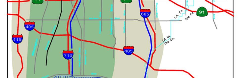
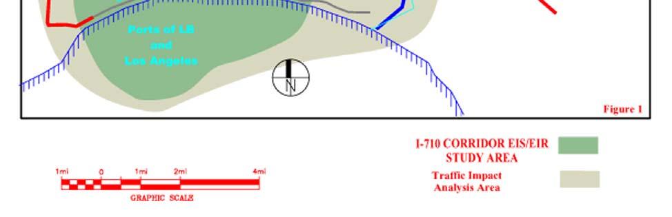
95 95 Figure 1: Project Study Area
96 Figure 2 I-710 Project Governance Structure Metro Board I-710 Executive Committee Metro GCCOG Caltrans SCAG Los Angeles County I-710 EIR/EIS Project Committee Co-Chairs Port of Long Beach Port of Los Angeles I-710 EIR/EIS Project Committee Community Input and Public Participation Bell Bell Gardens Carson Commerce Compton Cudahy Downey Huntington Park Long Beach Lynwood Maywood Paramount South Gate Vernon County of Los Angeles Metro Caltrans SCAG Port of Long Beach Port of Los Angeles SGVCOG I-5 JPA Goods Movement Strategy Advisory Group (A resource group on call for advice & assistance on legislative, regulatory and other specialized issues) Technical Advisory Committee (TAC) 96
97 Table 1 (Major N/S and E/W Arterial Highways and Intersections in the I-710 study area) Anaheim Street SR-1 Willow Street Del Amo Blvd Long Beach Blvd W-E Alondra Blvd North/South Santa Fe Santa Fe Alameda Wilmington Rosecrans Alameda North/South Alameda Alameda Santa Fe Alameda Alondra Santa Fe North/South Magnolia Long Beach BlvdLong Beach BlvdSanta Fe Artesia Long Beach Blvd North/South Long Beach Atlantic Blvd Atlantic Blvd Long Beach Blvd DelAmo Atlantic Blvd North/South Cherry Ave Cherry Ave Cherry Ave Atlantic Blvd Garfield North/South Cherry Ave Paramount North/South Lakewood West/East Rosecrans Ave. Imperial Highway Firestone Blvd Florence Ave. Slauson Ave. Atlantic Blvd. No-So North/South Willowbrook Alameda Atlantic Alameda Alameda Florence North/South Alameda Long Beach BlvdCalifornia Atlantic Blvd Soto Slauson W-E North/South Santa Fe Ave Atlantic Long Beach BlvdEastern Atlantic Blvd.Bandini W-E North/South Long Beach Blvd Garfield Garfield Garfield Eastern North/South Atlantic Paramount Blvd Paramount Blvd Paramount Blvd Paramount North/South Garfield North/South Paramount Blvd West/East Bandini Washington Blvd Olympic Blvd Whittier Blvd Beverly Rd 3rd Street/Pomona North/South Santa Fe Alameda Alameda Alameda Atlantic Indiana St North/South Atlantic Blvd Santa Fe Ave Santa Fe Ave Santa Fe Ave Findlay Eastern North/South Eastern Ave Atlantic Ave Soto St Soto St Garfield Ford Blvd North/South Eastern Ave Indiana Indiana Paramount Beverly Blvd North/South Eastern Ave Eastern Ave Atlantic Blvd North/South Telegraph Telegraph North/South Ford Rd Ford Rd North/South Arizona Rd Arizona Rd North/South Atlantic Atlantic Caesar Chavez West/East Ave North/South Soto St North/South Indiana St North/South Eastern North/South Humphreys North/South Ford Blvd North/South Atlantic Blvd Pacific Ave No-So Willow St. SR-1 Anaheim St. 97
98 TABLE 2 Gateway Cities Truck Impacted Intersections Phase I and Phase II Intersection Improvements* Phase I Artesia Blvd/Pioneer Blvd - City of Artesia Eastern Ave/Bandini Blvd City of Bell Atlantic Ave/Florence Ave City of Bell Lakewood Blvd/Artesia Blvd City of Bellflower Atlantic Ave/Florence Ave City of Cudahy Patata St/Atlantic Ave City of Cudahy Florence Ave/Paramount Blvd City of Downey Slauson Ave/Santa Fe Ave City of Huntington Park Slauson Ave/Telegraph Rd Cities of Commerce/Montebello South St/Woodruff Ave City of Lakewood South St/Bellflower City of Lakewood Greenwood Ave/Washington Blvd City of Montebello Imperial Hwy/Norwalk Blvd City of Norwalk Imperial Hwy/Studebaker City of Norwalk Phase II Ajax Ave / Florence Ave - City of Bell Gardens Jaboneria Ave / Florence Ave City of Bell Gardens Florence Ave / Scout Ave City of Bell Gardens Artesia Blvd / Lakewood Blvd City of Bellflower Washington Blvd / Ayers Ave - City of Commerce Sheila St / Arrowmill Ave - City of Commerce Bickett St / Slauson Ave City of Huntington Park Randolph St / Maywood Ave - City of Huntington Park Del Amo Blvd / Pioneer Blvd - City of Lakewood Santa Fe Ave /Anaheim St - City of Long Beach Maywood Ave / Slauson Ave City of Maywood Rosecrans Ave/Garfield Ave City of Paramount Norwalk Blvd/Telegraph Rd City of Santa Fe Springs Soto St/37th St/Bandini Blvd City of Vernon Rosemead Blvd/Washington Blvd City of Pico Rivera Rosemead Blvd/Whittier Blvd City of Pico Rivera Slauson Ave/State St & Boyle Ave Huntington Park/Vernon Atlantic Blvd/Bandini Blvd City of Vernon Patata St/Atlantic Ave City of South Gate Firestone Blvd/Garfield Ave City of South Gate Santa Fe Ave/Pacific Coast Hwy City of Long Beach Imperial Hwy/Martin Luther King Blvd. City of Lynwood Atlantic Blvd/Slauson Ave City of Maywood Alondra Blvd/Central Ave City of Compton Alondra Blvd/Wilmington Ave City of Compton Maywood Ave / Fruitland Ave - City of Maywood Washington Blvd / Maple Ave City of Montebello Washington Blvd / Vail Ave City of Montebello Olympic Blvd / Vail Ave City of Montebello Telegraph Rd / Greenwood Ave City of Montebello Imperial Hwy / Bloomfield Ave City of Norwalk Rosecrans Ave / Studebaker Rd City of Norwalk Paramount Blvd / Alondra Blvd - City of Paramount Alondra Blvd / Valley View Ave - Cities of Santa Fe Springs and La Mirada Firestone Blvd / Rayo Ave - City of South Gate * Table subject to revision by Consultant 98


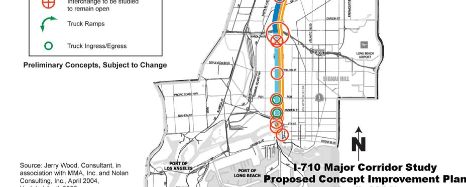
99 Appendix A Hybrid Design Concept 99
100 Appendix B FACILITATION OF COMMUNITY PARTICIPATION IN THE I-710 CORRIDOR ENVIRONMENTAL IMPACT REPORT/ENVIRONMENTAL IMPACT STUDY (EIR/EIS) PREFACE Facilitation of Community Participation in Work Elements 1 and 2 contained in the I-710 Corridor EIR/EIS Scope of Work will be awarded using a separate Request for Proposal (RFP). For clarification purposes, facilitation of community participation is not a study ; it is a process and program by which the communities are able to provide input into EIR/EIS documents. All community participation work associated with the I-710 EIR/EIS will be performed within the Community Participation Framework that has been adopted by the I-710 Project Committee and concurred to by the I-710 Executive Committee. Community relations consultants who wish to participate in community participation work for the I-710 EIR/EIS are required to submit a proposal either as a Prime Community Participation Firm or as a sub-consultant to a Community Participation Prime. No funding for community participation work is allocated, nor will be awarded, outside of these parameters. 1.0 SCOPE This statement of work includes a background summary of the completed I-710 Major Corridor Study and Outreach Program; a description of the current EIR/EIS study and outreach effort; an overview of the community outreach structure for the EIR/EIS effort; an overview of the EIR/EIS outreach program development and implementation; and a delineation of contractor requirements. 1.1 BACKGROUND SUMMARY OF COMPLETED I-710 MAJOR CORRIDOR STUDY AND OUTREACH PROGRAM On October 26, 2000, the MTA Board authorized staff, in partnership with Caltrans, the Gateway Cities Council of Governments (GCCOG) and the Southern California Association of Governments (SCAG), to conduct a comprehensive study regarding future transportation alternatives and improvements for the I-710 Corridor between State Route 60 and the twin seaports of Los Angeles and Long Beach. The study was designed to identify air quality, congestion, safety, and traffic operation problems in the Corridor and to develop mobility solutions, which are consistent with the desires of the local communities and residents. In the spring of 2003 the Final Set of Alternatives for the for I-710 Corridor were presented to the community: Two of the alternatives were No Build and Transportation System Management/Transportation Demand Management (TSM/TDM), and the remaining three were build alternatives requiring significant acquisition of private property. In May 2003, and in response to community opposition to all of the proposed build alternatives, the MTA Board and the I-710 Oversight Policy Committee (OPC, representing the corridor communities) initiated a renewed community participation effort to develop community consensus around a yet-to-be defined hybrid strategy. The Board approved a 100
101 motion that called for MTA staff to support the TSM/TDM Alternative and to work with the various entities to develop a hybrid alternative using elements from the build alternatives with special attention to reducing property acquisitions and improving Corridor air quality. In doing so, the Board directed staff to develop a more inclusive public participation process to generate ideas and recommendations for solutions from those communities that experience the burdens associated with I-710 traffic on a day-to-day basis. The Board further directed that Community Advisory Committees (CACs) be formed in key areas along the Corridor. Consistent with the MTA Board motion, the OPC also called for the development of CACs and adopted a set of guiding principles that were used to govern the conduct of the remainder of the I-710 Major Corridor Study and outreach effort. One of those guiding principles read, Improve public participation in the development and consideration of alternatives and provide technical assistance to facilitate effective public participation. MTA and GCCOG staff worked with local jurisdictions to identify residents and local business owners to participate directly in the identification of issues and areas of opportunity for the I-710 freeway. These community advisory committees or CACs become known as Tier 1 grass roots committees and the Tier 2 corridor-wide committee. In the more participatory and expanded outreach effort, MTA provided facilitators to assist corridor communities with the formation and implementation of CACs. In tandem with this effort, the GCCOG retained an engineer to work directly with the Tier 1 CACs and local city public works staff to identify community level freeway engineering design issues and solutions. The Tier 1 CACs consisted of local community members from highly impacted neighborhoods appointed by their respective City Councils. Six cities and the unincorporated area of East Los Angeles (where appointments were made by the County Supervisor) formed Tier 1 Committees. The City of Long Beach developed its own public involvement and engineering process to reach consensus on a freeway design within their city limits, and this work was integrated with the work of the rest of the Corridor. The Tier 2 CAC represented a broad base of interests, including representatives from local communities, academia, and environmental, labor, health, air quality, economic and environmental justice interests. Each Tier 1 CAC selected its own representative to Tier 2. The charge of the Tier 2 Committee was to: (1) review key local issues and opportunities identified by the Tier 1 community advisory committees, (2) consider issues of local and regional importance from a corridor-wide perspective, and (3) provide recommendations to the Oversight Policy Committee for a comprehensive transportation solution for the I-710 Corridor. The Tier 2 CAC met over the course of approximately one year and developed a report of issues, concerns, conditions and recommendations for improving the I-710 freeway and the Corridor entitled Major Opportunity/Strategy Recommendations and Conditions. The report may be viewed at This input was instrumental in developing a consensus on the I-710 Hybrid alternative or Locally Preferred Strategy (LPS). 101
102 The LPS that emerged from this process dramatically reduces property acquisition compared with the previously studied alternatives; improves safety by separating truck traffic from automobiles; and reduces emissions by improving operating truck speeds. It accomplishes this by: (1) using utility right-of-way; (2) generally maintaining the existing right-of-way line adjacent to neighborhoods and expanding the freeway towards the Los Angeles River; (3) moving the freeway centerline; and (4) utilizing design exceptions from established federal and state freeway design standards at selected freeway sections and interchanges. 1.2 Completion of Major Corridor Study (MCS) The Tier 1 and Tier 2 CACs along with the Technical Advisory Committee completed their work and submitted their final recommendations to the I-710 Oversight Policy Committee (OPC). On November 18, 2004, the Oversight Policy Committee voted unanimously to adopt the I-710 Major Corridor Study s Locally Preferred Strategy. The OPC also directed that: (1) the Tier 2 CAC report be forwarded in its entirety as pre-scoping guidance in the preparation of the EIR/EIS; (2) the Gateway Cities Council of Governments provide leadership for the development and implementation of a Corridor level air quality action plan; (3) the Gateway Cities COG pursue avenues to implement those Tier 2 recommendations that exceed the scope of any I-710 transportation improvements; and (4) MTA and Gateway Cities COG suggest a process for continuing community participation throughout the environmental analysis. On January 27, 2005 the MTA Board adopted the draft final report on the I-710 Major Corridor Study which defines the Locally Preferred Strategy (LPS) for corridor improvements and which was developed with extensive collaboration and input from communities and stakeholders along the corridor. The MCS Compliance report documents how the proposed improvements to the I-710 complies with the Intermodal Surface Transportation Efficiency Act of 1991 (ISTEA) requirements and MCS guidance, and is consistent with the MCS proposed project objectives. As part of the MCS, conceptual alternatives were developed for the I-710 Corridor. The MCS No-Build and Transportation Systems Management/Transportation Demand Management (TSM/TDM) Alternatives include a number of freeway improvement alternatives and other transportation alternatives. In addition, a locally preferred strategy (LPS), called the Hybrid design, was adopted in The Hybrid design includes a full standard 10-lane mixed flow, at-grade facility next to four truck lanes, separated from the 10- mixed flow lanes for a total of 14 lanes. The truck lanes are mostly at-grade. Finally, the Hybrid design includes a separate study of the I-5/I-710 interchange to address the concerns of the two communities (Commerce and East Los Angeles) that border it. 2.0 CURRENT EIR/EIS STUDY AND COMMUNITY OUTREACH EFFORT The I-710 EIR/EIS Study Area extends approximately 18 miles and encompasses the following cities/jurisdictions: Bell, Bell Gardens, Carson, Commerce, Compton, Cudahy, Downey, Huntington Park, Long Beach, Lynwood, Maywood, Paramount, South Gate, Vernon, unincorporated East Los Angeles, Port of Los Angeles, and Port of Long Beach. The 102
103 I-710 Corridor EIR/EIS RFP describes the Purpose and Need for the Project, the Project Background, the Initial Project Alternatives, and Scope of Work that will be analyzed in the environmental process as set forth in the Environmental/Engineering Scope of Work. It should be understood that the Initial Project Alternatives may be modified in response to the project scoping process. 2.1 Technical Process Milestones of the EIR/EIS An aggressive EIR/EIS schedule proposes to complete the environmental process within three (3) years. The technical consultants (Engineering and Environmental) primary action items and corresponding due dates are set forth below. EIR/EIS SCHEDULE (Preliminary) Milestone/Items/Action Due Date Pre-work Meeting 05/11/07 Start Work 05/28/07 Field Meeting 06/27/07 Initiate Public Scoping 07/28/07 All Draft Technical Studies completed by Consultant 05/28/08 Value Analysis 06/27/08 Admin. Draft Environmental Document (DED) 07/28/08 Project Team (QA/QC) 09/10/08 Comments Sent to Consultant 10/28/08 Revised DED Submitted to Caltrans Deputy Project Manager for Environmental 12/28/08 DED Approved by Caltrans & Sent to FHWA 02/27/09 Comments Received From FHWA Sent to Consultant 04/27/09 Revised DED Sent to FHWA 06/11/09 FHWA Approval to Circulate DED 07/28/09 DED Circulation 08/27/09 Public Hearing 09/27/09 Response to Comments/Complete FED 11/27/09 Project Team (QA/QC) 01/11/09 Comments Sent To Consultant 01/27/10 Revised FED Sent to Caltrans Deputy Project Manager for Environmental 03/30/10 FED Sent To FHWA/Review and Comment 05/28/10 FHWA Signs ROD and Department Signs NOD 11/27/10 Notice of Determination Sent to Office of Planning and Research 12/28/ Major Community Outreach Milestones within the EIR/EIS Process There are nine (9) major public outreach milestones that will occur during the EIR/EIS process. 103
104 Major Public Outreach Milestones Start - Finish Date Scoping preparation 06/01/07-07/01/07 Scoping recommendations 09/15/07-10/15/07 Health risk study guidelines 11/01/07-12/15/07 Significant alternatives refinement 01/01/08-03/01/08 Value Analysis 04/01/08-06/01/08 Draft circulation (including proposed mitigations) 07/01/09-08/15/09 Post-circulation comments review 10/01/09-11/01/09 Pre-final EIS recommendations on project 12/01/09-01/01/10 Mitigation monitoring recommendations 06/01/10 08/01/ Project Documents Technical documents will be provided by the Environmental and Engineering Consultant(s). Some of these documents may be subject matter that is relevant to the work of the community advisory committees and subject working groups that are described in Section 3.0. Most of the documents will be incorporated into the Draft Environmental Document. These documents are noted below: Multimodal Review Report Traffic Model Demand Forecast Study Community Impact Assessment Report Farmlands/Agricultural Lands Impact Assessment Report Visual Impact Assessment Report Noise Study Report Air Quality Report Health Risk Assessment Report Water Quality Report Utilities Impact and Relocation Report Emergency and Community Facilities Report Energy Study Geotechnical Evaluation Report Initial Site Assessment Preliminary Site Investigation Draft Relocation Impact Study Draft Location Hydraulic Study/Floodplain Report Los Angeles River Impacts Assessment Report Paleontological Identification Report Paleontological Evaluation Report Paleontological Monitoring Plan Biological Assessment Report Wetland Delineation Report Natural Environment Study Report Historic Survey Report Historical Resource Evaluation Report Cultural Resources Study Historical Records Technical Report 104
105 Historic and Architectural Resource Studies Technical Report Section 4(f) Evaluation 2.4 Governance Structure for the I-710 EIR/EIS The I-710 EIR/EIS Executive Committee is comprised of members of the funding partners and the Co-chairs of the I-710 Project Committee and is responsible for the coordination of appropriate aspects of the project, including policy assistance and guidance on legislative, regulatory, financial and other specialized issues that arise during the course of the study. The I-710 Project Governance Structure includes the I-710 Project Committee which is responsible for the management of the EIR/EIS. It includes 15 communities along the I-710 Corridor as well as the study s agency funding partners, the San Gabriel Valley Council of Governments, and the I-5 JPA. The Technical Advisory Committee includes city engineers and environmental professionals from the member agencies of the Project Committee and from the California Highway Patrol, Federal Highway Administration, Federal Transit Administration and the South Coast Air Quality Management District. The Goods Movement Strategy Advisory Group is a resource group on call for advice and assistance on legislative, regulatory, financial and other specialized issues. Participation in this group will be determined at a later date. The Community Participation Structure is described below in Sections 2.5 and 3.0. Exhibit A illustrates the EIR/EIS I-710 Project Governance Structure. 2.5 FORMATION AND ROLE OF COMMUNITY ADVISORY COMMITTEES (CACS) On September 14, 2006, the I-710 Project Committee requested that its members work with their respective city councils to develop Community Advisory Committees for the I-710 EIR/EIS. Recommendations from each of the city council representatives are to be presented at an upcoming Project Committee meeting. As set forth in the Project Committee s adopted motion to form CACs, the roles and responsibilities of the CACs are as follows: The primary role of the CACs is to provide input into Program Documents while they are still in the outline or draft stage. Program Documents include those documents that are produced by the consultant team that has been selected to undertake the preparation of the EIR/EIS. Additionally, the GCCOG may produce documents concerning the Corridor Air Quality Action Plan and Tier 2 recommendations that may exceed the scope of the EIR/EIS. However, the consultant selected under this procurement will be responsible only for facilitating input into those documents which are directly related to the preparation of the EIR/EIS. Assist the Project Committee and the Technical Advisory Committee in communicating information about the I-710 EIR/EIS to their respective communities. 105
106 Solicit community (residents, businesses, institutions, labor, environmental and health interests, etc.) input and engagement on issues of local and regional importance relating to the present and future of the I-710 Corridor from the Port of Long Beach to SR-60. Encourage a representative and broad base of community participation both within and beyond the CACs. Provide mechanisms to incorporate and respond to public input in the development of the EIR/EIS. Promote constructive dialogue in an environment of trust, credibility and mutual respect in the community outreach process and in the EIR/EIS development process. 3.0 COMMUNITY OUTREACH STRUCTURE The Project Committee has adopted a recommended outreach structure within which Proposer s facilitation services will be performed. Exhibit B illustrates the Community Participation Framework for the I-710 EIR/EIS. This structure is as follows: 3.1 Local Advisory Committees (LACs) Maximum number of LACs is 18 A Local Advisory Committee may be established in each of the 14 corridor cities and in unincorporated East Los Angeles. Each Corridor Community may, through its City Council (or for unincorporated areas through its County Supervisor), establish a local advisory committee whose focus is strictly on issues related to the I-710 Corridor and its current and future impacts on their communities. (NOTE: The City of Long Beach, which contains slightly more than one-third of the 18-mile freeway frontage, may identify up to four LACs). The formation of LACs in less impacted corridor cities - that is, those with no previously identified potential right-of-way issues - is optional. The corridor city council representatives on the Project Committee will report on their respective city council LAC nominations at a future meeting of the full Project Committee. Members of LACs will be drawn from impacted neighborhoods and are encouraged to incorporate representation from existing neighborhood-based associations and from the Tier 1 committees from the earlier Major Corridor Study phase of the project. Each LAC will elect a chairperson to guide the meetings. 3.2 Subject Working Groups (SWGs) Based on the diversity of community perspectives, the EIS/EIR phase of the project will include three working groups organized by topic areas. These include: (1) Environment SWG (issues concerning health, air quality, watershed) (2) Transportation SWG (issues concerning transit, TDM, TSM, new technology, regional traffic, local street and arterials, freeway improvement designs) 106
107 (3) Community Design and Local Economics SWG (enhancements, streetscapes, jobs, training, economic development, project finance) Each of the three SWGs will include one representative from each of the LACs (maximum 18), one representative from the Technical Advisory Committee, and up to 10 stakeholders appointed by the Project Committee. The maximum number of members in each SWG will be Corridor Advisory Committees The Corridor Advisory Committee is a broad based corridor-wide body whose membership will consist of: Chair of each LAC For each community that does not have a LAC, a member appointed by the City Council or County Supervisor. 5 representatives from each of the three SWGs Chair of the I-710 Technical Advisory Committee Up to 5 additional members appointed by the Project Committee In order to supplement the CACs ability to engage additional perspectives or interests that it deems important, the Project Committee will delegate to the CAC chairs the authority to appoint up to 5 representatives by three-quarter vote. With the professional facilitator as a resource, this CAC will structure itself and its work based on key topic areas that are identified by the LAC and SWG committees. 3.4 Flow of Information and Recommendations and Feedback Loops The LACs and the SWGs provide direct input to the CAC. The CAC provides direct input to the TAC and the Project Committee. The Project Committee provides direct input to the I-710 Executive Committee. The CAC is also charged with providing feedback to the LACs and SWGs. 4.0 REQUIREMENTS FOR OUTREACH PROGRAM DEVELOPMENT AND IMPLEMENTATION The Community Participation Consultant will work closely with the MTA Director of Constituent Programs and the MTA Project Manager to facilitate community engagement throughout the I-710 EIR/EIS process. The duration of the community outreach program will be approximately three years. The Community Participation Consultant will be responsible for providing all services identified in section 4.1 through 4.9 of this scope, and those services generally fall into the following six key areas: 107
108 Outreach program initiation and coordination with funding partners Meeting coordination and facilitation, including focused outreach with high-impact communities Issues management and consultation with experts in trade, commerce, legislative, and legal matters, as may be requested by Project Committee and Executive Committee. Collateral material development (video, printed and web-based) Community Leadership Internship Program Speakers Bureau and Media Relations support Environmental and Engineering Coordination with Community Outreach A parallel environmental and engineering process will be performed by technical Consultant(s) under separate contract with MTA. The Environmental and Engineering Consultant(s) will coordinate closely with the Community Participation Consultant and provide the necessary materials, support and staff for this coordination. The primary mechanism for coordination will be regularly scheduled internal team meetings among the Project Team, including lead staff from the Community Participation Consultant, the Environmental Consultant, and the Engineering Consultant. The technical Consultant(s) will periodically meet with the CACs and other groups to demonstrate how community issues and recommendations are being addressed within the scope and context of the I-710 EIR/EIS. The I-710 Project Committee and the Gateway Cities Council of Governments will be responsible for community outreach with the CACs for issues and recommendations that may fall outside the scope and context of the EIR/EIS. Day-to-day management of the Community Participation Consultant work will be the responsibility of MTA s Director of Constituent Program Management. Any changes in scope of work, time tables, deliverables, etc. will require approval by the MTA Project Manager before proceeding. 4.1 Outreach program initiation and coordination Scoping assistance Assistance in the formation of the LACs, SWGs, and CAC and the election of CAC co-chairs Assist in the establishment of ground rules and procedures conducive to respectful dialogue during program document review Coordinate with outreach staff at funding agencies 4.2 Meeting Coordination and Facilitation Quarterly meetings of the 18 Local Advisory Committees (LACs) Quarterly meetings of the Environmental Subject Working Group (SWGs) Quarterly meetings of the Transportation/Transit Subject Working Group Quarterly meetings of the Local Economy & Community Design Subject Working Group Quarterly meetings of the Corridor Advisory Committee (CAC) 108
109 4.3 Meeting Attendance and Presentations, as requested Quarterly Executive Committee Meetings Quarterly Project Committee Meetings Quarterly Technical Advisory Committee Meetings Scoping Meetings Public Hearings Internal project team meetings at a maximum of two times per month. 4.4 Meeting Logistics Facility Locations/Set-up Agendas and meeting notes/minutes (for all meeting mentioned above) Translations (Spanish for all meetings and agendas; Vietnamese, Khmer and Tagalog as needed for City of Long Beach meetings.) PA Systems 4.5 Focused Outreach with High-Impact Communities In addition to supporting the LACs, there may be communities that require additional assistance due to special circumstances. 4.6 Specialty Issue Driven Outreach The Community Participation Consultant will assist, as required, with specialty issue driven outreach. The extent of this effort will be determined at a later date. Trade & Commerce Legislative Coordination with the Goods Movement Strategy Advisory Group. The extent of this effort shall be determined at a later date. 4.7 Collateral Material Development Corridor Video Documentary Website coordination with Metro and the Gateway Cities COG Quarterly Newsletters Bi-Annual Factsheets Environment Air Quality/Health Goods Movement Economics Design New Technology Printing (Note: Outreach consultant will be responsible for the printing of only those documents that it produces, i.e. newsletters and fact sheets) 109
110 4.8 Community Leadership Internship Program This program will provide internship opportunities for college students in the I-710 corridor cities and is strongly supported by the Gateway Cities Council of Governments. Interns will be working directly with leaders in their community who will be mentoring them for their own community leadership positions in the future. The interns will be assigned primarily to support their respective Local Advisory Committees. The Community Participation Consultant will be responsible for assisting the GCCOG with the Community Leadership Internship Program. The Community Leadership Internship Program will be administered by the Gateway Cities Council of Governments. The consultant s role will be to assist the GCCOG and the Project Team in the management of the work of the college interns. 4.9 Speakers Bureau and Media Relations support Arrange for quarterly presentations to community, business, media and professional organizations by staff members of the funding organizations Assist in the preparation of presentation materials. Bi-annual Op Eds in regional & national newspapers/business journals Tri-annual placements in professional publications Develop talking points as required, for project team members to refer to when addressing the press or important/sensitive issues. 5.0 DELIVERABLES All deliverables will be concurrently delivered to the MTA Director of Constituent Program Management and the MTA Project Manager. No. Description 1 Report re: committee formation 2 Report re: Development of Ground Rules and Procedures SOW TASK REF. # Frequency Date of First Action Date of Subsequent Action time 1 st Quarter time 1 st Quarter LAC meetings 5.2 Quarterly 2 nd Quarter following Notice to Proceed TBD 110
111 No. Description SOW TASK REF. # Frequency Date of First Action Date of Subsequent Action 4 Environmental SWG meetings 5.2 Quarterly 2 nd Quarter TBD 5 Transportation/ Transit SWG meetings 5.2 Quarterly 2 nd Quarter TBD 6 Local Economy/Community Design SWG meetings 5.2 Quarterly 2 nd Quarter TBD 7 Corridor Advisory Committee meetings 5.2 Quarterly 2 nd Quarter TBD 8 Executive Committee meetings 5.3 Quarterly, as needed 2 nd Quarter TBD 9 Project Committee meetings 5.3 Quarterly, as needed 2 nd Quarter TBD 10 Technical Advisory Committee meetings 5.3 Quarterly, as needed 2 nd Quarter TBD 111
112 No. Description 11 Public Hearings and Community Meetings SOW TASK REF. # Frequency w/deir 4 w/final EIR Date of First Action TBD 12 Meeting Logistics 5.4 On-going 1 st Quarter Date of Subsequent Action TBD TBD 13 Report on Focused Outreach program 5.4 Years 2 and 3 Year 2 TBD 14 Specialty issue Driven Outreach 5.6 As needed TBD TBD 15 Corridor Video Documentary time Due by end of 2 nd Quarter TBD 16 Website Coordination with Metro and the Gateway Cities COG time 1 st Quarter TBD 17 Newsletters 5.7 Quarterly 2 nd Quarter TBD 112
113 No. Description SOW TASK REF. # Frequency Date of First Action 18 Fact Sheets 5.7 Bi-Annual 2 nd Quarter Date of Subsequent Action TBD 19 Internship Program 5.8 On-going Yrs. 2 & 3 TBD 20 Speakers Bureau & Media Relations Support 5.9 On-going 2 nd Quarter TBD 113
114 LIST OF EXHIBITS Exhibit No. A B Description I-710 Project Governance Structure Community Participation Framework for the I-710 EIR/EIS 114
115 Exhibit A I-710 Project Governance Structure Metro Board I-710 Executive Committee Metro GCCOG Caltrans SCAG Los Angeles County I-710 EIR/EIS Project Committee Co-Chairs Port of Long Beach Port of Los Angeles I-710 EIR/EIS Project Committee Community Input and Public Participation Bell Bell Gardens Carson Commerce Compton Cudahy Downey Huntington Park Long Beach Lynwood Maywood Paramount South Gate Vernon County of Los Angeles Metro Caltrans SCAG Port of Long Beach Port of Los Angeles SGVCOG I-5 JPA Goods Movement Strategy Advisory Group (A resource group on call for advice & assistance on legislative, regulatory and other specialized issues) Technical Advisory Committee (TAC) 115

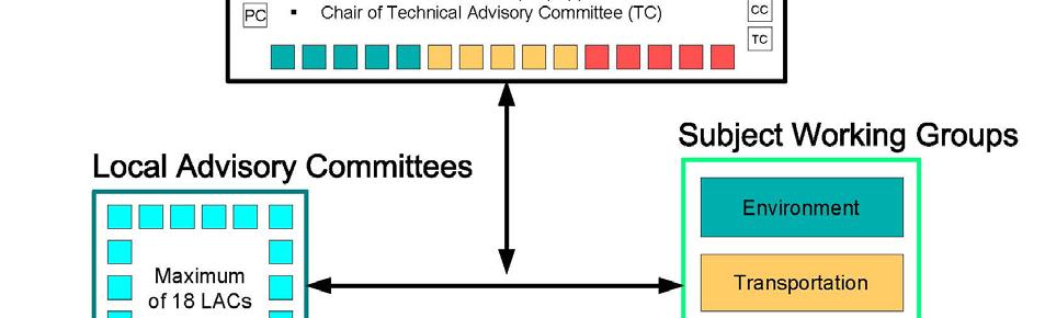
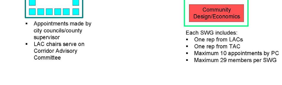
116 Exhibit B Community Participation Framework for the I-710 EIR/EIS 116
I-710 Corridor Project EIR/EIS Community Outreach Component Statement of Work RFP No. PS ISSUED:
 Los Angeles County Metropolitan Transportation Authority I-710 Corridor Project EIR/EIS Community Outreach Component Statement of Work RFP No. PS4340-1940 ISSUED: 11.20.06 RFP No. PS43401940 1 SOW FACILITATION
Strategic Transportation Plan FOCUS ON TRANSIT
 Strategic Transportation Plan FOCUS ON TRANSIT Presented to: Gateway Cities Service Council Presented by: Jerry Wood, GCCOG Director of Transportation and Engineering COG2013\2013 - POWER POINTS for JRW
TECHNICAL MEMORANDUM I-710 EIR/EIS INITIAL FEASIBILITY ANALYSIS (IFA) TECHNICAL APPENDIX WBS TASK ID:
 TECHNICAL APPENDIX WBS TASK ID:") FINAL REPORT TECHNICAL MEMORANDUM I-710 EIR/EIS INITIAL FEASIBILITY ANALYSIS (IFA) TECHNICAL APPENDIX WBS TASK ID: 165.10.09 Prepared for Los Angeles County Metropolitan Transportation Authority December
FINAL REPORT TECHNICAL MEMORANDUM I-710 EIR/EIS INITIAL FEASIBILITY ANALYSIS (IFA) TECHNICAL APPENDIX WBS TASK ID: 165.10.09 Prepared for Los Angeles County Metropolitan Transportation Authority December
6.0 CONGESTION HOT SPOT PROBLEM AND IMPROVEMENT TRAVEL DEMAND MODEL ANALYSIS
 6.0 CONGESTION HOT SPOT PROBLEM AND IMPROVEMENT TRAVEL DEMAND MODEL ANALYSIS 6.1 MODEL RUN SUMMARY NOTEBOOK The Model Run Summary Notebook (under separate cover) provides documentation of the multiple
Truck Management ` Strategies in Los Angeles
 Truck Management ` Strategies in Los Angeles Susan Bok, AICP Senior Transportation Planner Los Angeles Department of Transportation NACTO Chicago Workshop May 11-12, 2009 Context Population Downtown LA
DRAFT SCOPE OF WORK SOUTHEAST LOS ANGELES COUNTY (SR-91/I-605/I-405) FREEWAY CORRIDORS MAJOR CORRIDORS STUDY
 FREEWAY CORRIDORS MAJOR CORRIDORS STUDY") DRAFT SCOPE OF WORK SOUTHEAST LOS ANGELES COUNTY (SR-91/I-605/I-405) FREEWAY CORRIDORS MAJOR CORRIDORS STUDY 1 SCOPE OF WORK Southeast Los Angeles County (SR-91/I-605/I-405) FREEWAY CORRIDORS STUDY I.
DRAFT SCOPE OF WORK SOUTHEAST LOS ANGELES COUNTY (SR-91/I-605/I-405) FREEWAY CORRIDORS MAJOR CORRIDORS STUDY 1 SCOPE OF WORK Southeast Los Angeles County (SR-91/I-605/I-405) FREEWAY CORRIDORS STUDY I.
I-710 Project Committee Meeting
 Los Angeles County Metropolitan Transportation Authority I-710 Project Committee Meeting January 29, 2009 Meeting Expectations Review I-710 planning context Concur on a port cargo forecast scenario to
Vicinity Map. Interstate 605 (I-605) and State Route 91 (SR-91) in Los Angeles County
 and State Route 91 (SR-91) in Los Angeles County") 07 - LA - 605 - PM 2.87/PM 6.36 07 - LA - 91 - PM 14.10/PM 19.81 Vicinity Map N On Routes Interstate 605 (I-605) and State Route 91 (SR-91) in Los Angeles County I-605 between Excelsior Dr UC (PM 6.36)
07 - LA - 605 - PM 2.87/PM 6.36 07 - LA - 91 - PM 14.10/PM 19.81 Vicinity Map N On Routes Interstate 605 (I-605) and State Route 91 (SR-91) in Los Angeles County I-605 between Excelsior Dr UC (PM 6.36)
Strategic Transportation Plan. Presented to: ECO-Rapid Transit Board of Directors Presented by: Gill V. Hicks, Cambridge Systematics, Inc.
 Strategic Transportation Plan Presented to: ECO-Rapid Transit Board of Directors Presented by: Gill V. Hicks, Cambridge Systematics, Inc. June 11, 2014 1 Local Solutions for all Gateway Cities Communities
Gateway Cities Council of Governments
 VIII. REPORTS ITEM C Status of the Strategic Transportation Plan (STP) Structure, Approval Process, and Schedule Presentation by Yvette Kirrin, COG Consultant Engineer Page 16 Gateway Cities Council of
Richard Clarke Executive Director Program Management. Capital Program Management
 Richard Clarke Executive Director Program Management Capital Program Management Department Overview > Transit, Highway Programs, and Regional Rail o Transit Deliver construction projects on-time and within
5.0 ALTERNATIVE REFINEMENTS AND EVALUATION
 5.0 ALTERNATIVE REFINEMENTS AND EVALUATION During Alternatives Evaluation, several technical studies were performed on the Final Set of Alternatives. The purpose of these studies was to elicit evaluative
The Caltrans Contract Manager will assign specific projects to the Consultant through the issuance of Task Orders.
 Scope of Work/Deliverables Environmental Services for Project Specific High Desert Corridor Area of Los Angeles and San Bernardino Counties (District 7 & 8) Attachment 1 Page 1 of 11 A. Project Description
3.6 GROUND TRANSPORTATION
 3.6.1 Environmental Setting 3.6.1.1 Area of Influence The area of influence for ground transportation consists of the streets and intersections that could be affected by automobile or truck traffic to
THE PROJECT. Executive Summary. City of Industry. City of Diamond Bar. 57/60 Confluence.
 THE PROJECT A freeway segment ranked 6th worst in the Nation, with levels of congestion, pollution and accidents that are simply unacceptable and which have Statewide and National implications. Executive
INTELLIGENT TRANSPORTATION SYSTEMS APPENDIX
 INTELLIGENT TRANSPORTATION SYSTEMS APPENDIX Southern California Association of Governments ADOPTED APRIL 2012 INTELLIGENT TRANSPORTATION SYSTEMS Introduction 1 Existing System Description 1 Existing System
THIS PAGE INTENTIONALLY LEFT BLANK.
 THIS PAGE INTENTIONALLY LEFT BLANK. DRAFT ENVIRONMENTAL IMPACT STATEMENT/ENVIRONMENTAL IMPACT REPORT LEAD AGENCIES: Federal Transit Administration, U.S. Department of Transportation and Los Angeles County
FACT SHEETS LOS ANGELES COUNTY
 FACT SHEETS LOS ANGELES COUNTY WHAT IS THE REGIONAL TRANSPORTATION PLAN/ SUSTAINABLE COMMUNITIES STRATEGY (RTP/SCS) Every four years the Southern California Association of Governments (SCAG) prepares a
Connected/Autonomous Vehicles in a
 Connected/Autonomous Vehicles in a Freight Corridor: Implementation Issues and Assumptions presented to ITS 3C Summit 2014 Mobile, AL presented by Cambridge Systematics, Inc. Kenny Voorhies, PE, PTOE September
Northwest State Route 138 Corridor Improvement Project
 Northwest State Route 138 Corridor Improvement Project Los Angeles County, CA DISTRICT 7- LA- 138 (PM 0.0/36.8); DISTRICT 7- LA- 05 (PM 79.5/83.1); DISTRICT 7- LA- 14 (PM 73.4/74.4) 265100/ 0700001816
Notice of Preparation For Link Union Station (Link US) Project. Joint Environmental Impact Statement and Environmental Impact Report
 Project. Joint Environmental Impact Statement and Environmental Impact Report") Notice of Preparation For Link Union Station (Link US) Project Joint Environmental Impact Statement and Environmental Impact Report Date: May 27, 2016 To: Subject: Project Title: From: All Interested Agencies,
Notice of Preparation For Link Union Station (Link US) Project Joint Environmental Impact Statement and Environmental Impact Report Date: May 27, 2016 To: Subject: Project Title: From: All Interested Agencies,
SR 710 Environmental Study
 SR 710 Environmental Study Alternatives Analysis s Technical Advisory Committee Meeting No. 5 May 9, 2012 1 1 Agenda > Recap of TAC Meeting No. 4 > Recommended alternative concepts for conceptual engineering
ITS NEWS. Building Southern California s Goods Movement System for the Next Century. Gateway Cities. I-710 Zero Emissions Freight Corridor
 Building Southern California s Goods Movement System for the Next Century Gateway Cities ITS NEWS Summer 2013 I-710 Zero Emissions Freight Corridor PAGE 4 FRATIS Demonstration Advances PAGE 10 ALSO IN
Regional Connector Transit Corridor Project Draft Environmental Impact Statement/ Draft Environmental Impact Report
 Los Angeles County Metropolitan Transportation Authority Regional Connector Transit Corridor Project Draft Environmental Impact Statement/ Draft Environmental Impact Report Public Scoping Meeting 1 Agenda!
West Santa Ana Branch Transit Corridor. Draft EIS/EIR Scoping Interagency Meeting June 19, 2017
 West Santa Ana Branch Transit Corridor Draft EIS/EIR Scoping Interagency Meeting June 19, 2017 Agenda > Welcome and Introductions > Purpose of Interagency Scoping > Timeline and Process > Agency Coordination
TRANSPORTATION IMPACT ANALYSISGUIDELINES
 TRANSPORTATION IMPACT ANALYSISGUIDELINES ADOPTED OCTOBER2014 SANTACLARAVALLEYTRANSPORTATION AUTHORITY CONGESTION MANAGEMENTPROGRAM CONGESTION MANAGEMENT PROGRAM TRANSPORTATION IMPACT ANALYSIS GUIDELINES
Metro Blue Line Improvements & Project Update
 Metro Blue Line Improvements & Project Update February 9, 2018 MBL Operational Improvements - External Metro & LADOT coordination to identify traffic signal and intersection treatments aimed at increasing
FLORIDA DEPARTMENT OF TRANSPORTATION PROCEDURE DEVELOPMENT OF THE
 FLORIDA DEPARTMENT OF TRANSPORTATION PROCEDURE DEVELOPMENT OF THE FLORIDA INTRASTATE HIGHWAY SYSTEM Topic No.: 525-030-250-f Office: Systems Planning Effective Date: May 16, 2002 DEVELOPMENT OF THE FLORIDA
1.0 PROPOSED PROJECT 1.1 INTRODUCTION. I-710 Corridor Project EIR/EIS
 1.0 PROPOSED PROJECT 1.1 INTRODUCTION The California Department of Transportation (Caltrans), in cooperation with the Los Angeles County Metropolitan Transportation Authority (Metro), the Gateway Cities
Business Item Transportation Committee Item
 Business Item Transportation Committee Item 2008-88 Meeting date: March 24, 2008 Council meeting: April 9, 2008 ADVISORY INFORMATION Date: March 19, 2008 Subject: Lowry Avenue Intermodal Freight Connector
Metro Board Action: Motion 22.1
 Los Angeles County Metropolitan Transportation Authority Metro Board Action: Motion 22.1 Implementation Update presented to the Corridor Advisory Committee March 17, 2016 Background Motion 22.1 October
Future Build Alternative Traffic Forecasts and Level of Service Analysis
 4.2.10 Future Build Alternative Traffic Forecasts and Level of Service Analysis For the five Build Alternatives, study intersections within one mile of potential station locations were analyzed, as it
Metro. Board Report I-710 SOUTH CORRIDOR PROJECT EIR/EIS, SCOPE, BUDGET, AND SCHEDULE
 Metro Board Report Los Angeles County Metropolitan Transportation Authority One Gateway Plaza 3rd Floor Board Room Los Angeles, CA File #:2015-1656, File Type:Contract Agenda Number:21. PLANNING & PROGRAMMING
Transportation Committee
 Transportation Committee For the Metropolitan Council meeting of April 9, 2008 ADVISORY INFORMATION Date Prepared: March 27, 2008 Subject: Lowry Avenue Intermodal Freight Connector Committee Report Item:
SECTION SUMMARY. Section 3.3 Ground Transportation
 Section. Ground Transportation 0 0 0 SECTION SUMMARY Section., Ground Transportation, provides the following: A review of the ground transportation mitigation measures of the 00 EIS/EIR; A description
Intent to Prepare an Environmental Impact Statement for the South Bay Metro
 DEPARTMENT OF TRANSPORTATION Federal Transit Administration Intent to Prepare an Environmental Impact Statement for the South Bay Metro Green Line Extension Transit Corridor, Southwestern Portion of Los
Project Application. General Information ODOT PID. Primary County (3 char abrv) HAM/CLE HAM/CLE HAM ODOT. District. Project Manager (Contact Person)
 HAM/CLE HAM/CLE HAM ODOT. District. Project Manager (Contact Person)") Current Status (Tier 1, Tier 2 or New) Proposed Status (Tier 1 or Tier 2) Tier 2 Tier 2 Project Application General Information ODOT PID 86462 86463 86461 Project Sponsoring Agency ODOT Project Manager
Current Status (Tier 1, Tier 2 or New) Proposed Status (Tier 1 or Tier 2) Tier 2 Tier 2 Project Application General Information ODOT PID 86462 86463 86461 Project Sponsoring Agency ODOT Project Manager
PREPARED TESTIMONY OF LEE LISECKI. Q. Please state your name, professional position, and business address.
 Application 06-12-005 et al. Exhibit Date: August, 2008 PREPARED TESTIMONY OF LEE LISECKI Q. Please state your name, professional position, and business address. A. My name is Lee Lisecki. I am a principal
Summary. Preliminary Alternative Development and Screening. DEIS July 23, 2018
 What is the Carolina Crossroads Project? The South Carolina Department of Transportation (SCDOT), in cooperation with the Federal Highway Administration (FHWA), is proposing to upgrade and redesign a key
FEDERAL HIGHWAY ADMINISTRATION RECORD OF DECISION FOR THE LYNNWOOD LINK EXTENSION
 FEDERAL HIGHWAY ADMINISTRATION RECORD OF DECISION FOR THE LYNNWOOD LINK EXTENSION AUGUST 2015 Table of Contents 1 Decision... 1 1.1 Project Description... 2 1.2 Basis for the FHWA Decision... 7 1.2.1
SR 710 North Study. Technical Advisory Committee Meeting No. 16 August 13, 2014 Stakeholder Outreach Advisory Committee Meeting No. 12 August 14, 2014
 SR 710 North Study Technical Advisory Committee Meeting No. 16 August 13, 2014 Stakeholder Outreach Advisory Committee Meeting No. 12 August 14, 2014 1 1 1 Agenda Public Outreach Activities Project Report
5.0 PRELIMINARY ENVIRONMENTAL REVIEW
 5.0 PRELIMINARY ENVIRONMENTAL REVIEW 5.1 INTRODUCTION A preliminary environmental review was performed on the proposed freeway improvements that form Concept C, which encompasses the three freeway corridors
Chapter 6 Freight Plan
 Chapter 6 Freight Plan Overview This chapter presents a review and assessment of needs, deficiencies, policies and improvement options affecting the freight transportation system within the Medford Urban
Request for Proposals. Hillsdale Pedestrian/Bicyclist Bridge Design
 Request for Proposals Hillsdale Pedestrian/Bicyclist Bridge Design Public Works Department City of San Mateo 330 West 20th Avenue San Mateo, CA 94403 JUNE 13, 2013 The City of San Mateo (CITY) is accepting
DRAFT. SR-60 7 th Avenue Intersection Control Evaluation (ICE) I-605 Corridor Improvement Project (CIP) I-605/SR-60 EA# 3101U0
 I-605 Corridor Improvement Project (CIP) I-605/SR-60 EA# 3101U0") SR-60 7 th Avenue Intersection Control Evaluation (ICE) I-605/SR-60 EA# 3101U0 October 9, 2017 Contents 1 Purpose of ICE Memo... 1 2 Background... 1 3 Existing Interchange Deficiencies... 1 4 Context Sensitive
SR-60 7 th Avenue Intersection Control Evaluation (ICE) I-605/SR-60 EA# 3101U0 October 9, 2017 Contents 1 Purpose of ICE Memo... 1 2 Background... 1 3 Existing Interchange Deficiencies... 1 4 Context Sensitive
I-710 Technical Advisory Committee
 I-710 Technical Advisory Committee Wednesday, 1:30PM 3:00PM Gateway Cities Council of Government Offices 16401 Paramount Boulevard, 2 nd Floor Conference Room Paramount, CA AGENDA I. CALL TO ORDER II.
Port Cargo Scenarios Reviewed
 Los Angeles County Metropolitan Transportation Authority Overview of Technical Studies Presented to I-710 Corridor Advisory Committee January 21, 2009 Los Angeles County Metropolitan Transportation Authority
Los Angeles County Congestion Reduction Demonstration Project
 Los Angeles County Congestion Reduction Demonstration Project frequently asked questions update #1 /august 2008 Los Angeles County Metropolitan Transportation Authority (Metro), California Department of
State Route 710 North Environmental Study Update Online Media Briefing July 12, 2013
 State Route 710 North Environmental Study Update Online Media Briefing July 12, 2013 Frank Quon, P.E. Executive Officer, Metro Highway Program Michelle Smith, P.E. Project Manager, Metro Highway Program
Summary of Technical Memoranda 6a, 6b, and 7 for the Stakeholder Advisory Group. July 25, 2007
 1 Summary of Technical Memoranda 6a, 6b, and 7 for the Stakeholder Advisory Group July 25, 2007 2 Presentation Overview 1. Review of the Multi-County Goods Movement Action Plan (MCGMAP) study area and
Environmental Analysis, Chapter 4 Consequences, and Mitigation
 Environmental Analysis, Chapter 4 4.11 Energy Resources This section summarizes the energy resources in the project area, usage associated with construction and operation of the proposed Regional Connector
Request for Proposal (RFP 13-02)
") Request for Proposal (RFP 13-02) for Preparation of Scoping and Project Report, Environmental Document, Plans, Specifications and Estimate for I-680 North Segment Express Lane Conversion Posted on website
Request for Proposal (RFP 13-02) for Preparation of Scoping and Project Report, Environmental Document, Plans, Specifications and Estimate for I-680 North Segment Express Lane Conversion Posted on website
On behalf of the Carolina Crossroads project team we thank you for taking the time to attend this meeting.
 On behalf of the Carolina Crossroads project team we thank you for taking the time to attend this meeting. Located in the heart of South Carolina, the I-20/26/126 Corridor is the crossroads of the state
Chapter 10. Intelligent Transportation Systems. Ohio Kentucky Indiana Regional Council of Governments Regional Transportation Plan
 Chapter 10 Intelligent Transportation Systems Ohio Kentucky Indiana Regional Council of Governments 2030 Regional Transportation Plan Chapter 10 Intelligent Transportation Systems INTRODUCTION Intelligent
Technical Memorandum 3 Executive Summary Existing Conditions and Constraints Presentation. March 22, 2006
 Technical Memorandum 3 Executive Summary Existing Conditions and Constraints Presentation March 22, 2006 MCGMAP Overview Develop a: Goods Movement Action Plan M A X I M I Z E S Mitigation of communities'
INDIANA S INTERMODAL MANAGEMENT SYSTEM Stephen C. Smith Planning Manager, Transportation Planning Division Indiana Department of Transportation
 96 INDIANA S INTERMODAL MANAGEMENT SYSTEM Stephen C. Smith Planning Manager, Transportation Planning Division Indiana Department of Transportation Indiana is in the process of developing an Intermodal
GUIDE FOR THE PREPARATION OF TRAFFIC IMPACT STUDIES
 GUIDE FOR THE PREPARATION OF TRAFFIC IMPACT STUDIES Adopted by Town Council on November 25, 2008 Prepared By: HNTB Engineering Department Planning Department TABLE OF CONTENTS I. INTRODUCTION... 1 II.
III. ENVIRONMENTAL IMPACT ANALYSIS F. TRAFFIC
 III. ENVIRONMENTAL IMPACT ANALYSIS F. TRAFFIC This section summarizes the traffic impact analysis prepared by Kaku Associates in May, 2002. Detailed calculation worksheets are contained in Appendix D to
South Bay Metro Green Line Extension
 Meeting Agenda Project overview and update Recap of the Scoping Meetings Progress on the project alternative and proposed station locations Meeting Schedule 6:00 Open House 6:30 Presentation 7:15 Public
Comprehensive Regional Goods Movement Plan and Implementation Strategy Study Introduction and Overview
 Comprehensive Regional Goods Movement Plan and Implementation Strategy Study Introduction and Overview presented to Regional Goods Movement Steering Committee SCAG s Consulting Team: Cambridge Systematics,
Goods Movement Challenges. Opportunities. Solutions. Hasan Ikhrata Director of Planning & Policy Southern California Association of Governments
 Goods Movement Challenges. Opportunities. Solutions Hasan Ikhrata Director of Planning & Policy Southern California Association of Governments The Regional Planning Agency for Southern California 15 th
HOW DOES GOODS MOVEMENT AFFECT GATEWAY CITIES? 7/9/2013
 GATEWAY CITIES TECHNOLOGY PLAN FOR GOODS MOVEMENT LAEDC e-mobility Task Force July 9, 2013 Jerry R. Wood Director of Transportation and Engineering Gateway Cities Council of Governments Jerry@jrwoodconsultant.com
APPENDIX H Summary of Changes in the Recirculated Draft EIR
 APPENDIX H Summary of Changes in the Recirculated Draft EIR Southern California International Gateway Recirculated Draft EIR September 2012 APPENDIX H SUMMARY OF CHANGES The City of Los Angeles Harbor
Mendocino Forest Products Grading For Industrial Land Improvements
 Mendocino Forest Products Grading For Industrial Land Improvements Technical Memorandum #10 CEQA Evaluation of Environmental Impacts Prepared for: Mendocino Forest Products Company, LLC Consulting Engineers
Eastside Transit Corridor Phase 2
 Eastside Transit Corridor Phase 2 Community Meeting, June 22, 2016 Page 1 Purpose of Tonight s Meeting Page 2 Update on Metro Board directed Technical Study (Nov. 2014) SR-60 Alternative Washington Blvd
Northern Intermodal Transit Facility WHAT IS AN INTERMODAL TRANSIT FACILITY?
 WHAT IS AN INTERMODAL TRANSIT FACILITY? An intermodal transit facility gathers many modes of transportation together and is strategically located to increase destination alternatives. Intermodal facilities
Bow Concord I-93 Improvements City of Concord Transportation Policy Advisory Committee
 Bow Concord I-93 Improvements City of Concord Transportation Policy Advisory Committee December 15, 2016 Agenda Project History / Project Development Process Traffic Modeling Alternatives Development o
Environmental Impact Statement for the Green Line to the Airport Project. ACTION: Notice of Intent to Prepare an Environmental Impact Statement (EIS).
.") This document is scheduled to be published in the Federal Register on 11/18/2015 and available online at http://federalregister.gov/a/2015-29418, and on FDsys.gov DEPARTMENT OF TRANSPORTATION Federal Transit
This document is scheduled to be published in the Federal Register on 11/18/2015 and available online at http://federalregister.gov/a/2015-29418, and on FDsys.gov DEPARTMENT OF TRANSPORTATION Federal Transit
Date: May 4, Clare M. Look-Jaeger, P.E. Kevin C. Jaeger Linscott, Law & Greenspan, Engineers Weingart Projects Construction Traffic Analysis
 MEMORANDUM To: CAJA Environmental Services, LLC Date: From: Subject: Clare M. Look-Jaeger, P.E. Kevin C. Jaeger Linscott, Law & Greenspan, Engineers Weingart Projects Construction Traffic Analysis LLG
West Santa Ana Branch Transit Corridor. Draft EIS/EIR Scoping Meeting June 2017
 West Santa Ana Branch Transit Corridor Draft EIS/EIR Scoping Meeting June 2017 Agenda > Welcome and Introductions > Purpose of Scoping > Timeline and Process > Environmental Approach and Methodology >
Presentation Topics The Alameda Corridor Project Corridor Performance Goods Movement Challenges
 1 Presentation Topics The Alameda Corridor Project Corridor Performance Goods Movement Challenges 2 Ports of Los Angeles and Long Beach Largest port complex in the U.S. Fifth largest in the world Highest
Coalition for America s Gateways and Trade Corridors
 Coalition for America s Gateways and Trade Corridors ACS Solutions AECOM Alameda Corridor-East Construction Authority American Standard Companies Cascadia Center CenterPoint Properties Trust Chicago Metropolitan
Highway and Freight Current Investment Direction and Plan. TAC August 2, 2017
 Highway and Freight Current Investment Direction and Plan TAC August 2, 2017 Today s Topics Highway & Freight Where are we now? The Highway Story What are the issues? How is the system performing? Where
Database and Travel Demand Model
 Database and Travel Demand Model 7 The CMP legislation requires every CMA, in consultation with the regional transportation planning agency (the Metropolitan Transportation Commission (MTC) in the Bay
ORDER NO. An Order of the Board of Harbor Commissioners of the City of Los Angeles amending the Port of Los Angeles Tariff No. 4.
 ORDER NO. An Order of the Board of Harbor Commissioners of the City of Los Angeles amending the Port of Los Angeles Tariff No. 4. FINDINGS 1. On July 12, 1989, the Board of Harbor Commissioners of the
Gateway Cities Council of Governments Intelligent Transportation Systems Implementation Plan for Goods Movement
 Gateway Cities Council of Governments Intelligent Transportation Systems Implementation Plan for Goods Movement Streets and Freeways Subcommittee July 14, 2011 The Regional Problem Southeast Los Angeles
CLA /10.54, PID Project Description:
 Project Description: The proposed project will consist of widening IR 70 to three lanes from Enon Road (SLM 06.75) to the US 68 interchange ramps (SLM 10.55). IR 70 is a component of the Strategic Highway
Federal Way Transit Center to Tacoma Dome Light Rail
 Subarea South King/Pierce Primary Mode Light Rail Facility Type Corridor Length 9.7 miles Date Last Modified July 1, 2016 PROJECT AREA AND REPRESENTATIVE ALIGNMENT SHORT PROJECT DESCRIPTION This project
Dear Mr. Huerta, A hard copy will follow via US Mail. Best Regards,
 From: Alejandro Huerta [mailto:alejandro.huerta@lacity.org] Sent: Wednesday, November 18, 2015 1:41 PM To: Heidi Mekkelson; Stephanie Eyestone-Jones Subject: Fwd: Crossroads Hollywood_NOP_DEIR_Metro Comments
TRANSPORTATION IMPACT ANALYSIS GUIDELINES
 TRANSPORTATION IMPACT ANALYSIS GUIDELINES SANTA CLARA COUNTY TRANSPORTATION AUTHORITY CONGESTION MANAGEMENT PROGRAM ADOPTED MARCH 2009 TABLE OF CONTENTS PART I - STATUTE AND AUTHORITY...1 CHAPTER 1. CMP
Comparison of I-210 and I-710 as Potential ICM Corridors
 Comparison of I-210 and I-710 as Potential ICM Corridors Positive Aspects Traffic sensors Very good PeMS coverage of freeway mainline, HOV lanes, and ramps Many intersections within Pasadena already equipped
Environmental Impact Statement for the California High-Speed Rail System Burbank to Los Angeles Section, CA
 This document is scheduled to be published in the Federal Register on 07/24/2014 and available online at http://federalregister.gov/a/2014-17384, and on FDsys.gov 4910-06-P DEPARTMENT OF TRANSPORTATION
OPTIONAL STATIONAVIATION/MANCHESTER
 CRENSHAW/LAX TRANSIT CORRIDOR PROJECT FEIS/FEIR OPTIONAL STATIONAVIATION/MANCHESTER Aviation and Manchester, Looking East Aviation/Manchester Station (Optional) The Optional Aviation/Manchester Station
2 Purpose and Need. 2.1 Study Area. I-81 Corridor Improvement Study Tier 1 Draft Environmental Impact Statement
 2 Purpose and Need 2.1 Study Area Interstate 81 (I-81) is relied upon for local and regional travel and interstate travel in the eastern United States. It extends 855 miles from Tennessee to New York at
Final Recommendations Identification of Improvements, Strategies, and Solutions
 Identification of Improvements, Strategies, and Solutions Prepared by: December 2015 TABLE OF CONTENTS 1. Introduction... 1 1 2. Freight Policy Recommendations... 2 1 3. Freight Infrastructure Recommendations...
Central San Pedro Neighborhood Council Port Committee Meeting February 19, 2014 Augie Bezmalinovich Port of Los Angeles
 Central San Pedro Neighborhood Council Port Committee Meeting February 19, 2014 Augie Bezmalinovich Port of Los Angeles 1. Call to Order 2. Introduction of Guests 3. Consideration of Agenda 4. Port of
Exhibit A Mn/DOT Contract No
 Exhibit A Mn/DOT Contract No. 98142 SCOPE OF WORK AND DELIVERABLES Preliminary Design Red Wing US 63 Bridge and Approach Roadways State Project (SP) 2515-21 SCOPE OVERVIEW... 2 SCHEDULE... 2 PROJECT TASK
CHAPTER 5: TRANSPORTATION
 CHAPTER 5: TRANSPORTATION GOAL 12: TRANSPORTATION BACKGROUND SUMMARY INTRODUCTION Albany s location and transportation facilities provide excellent advantages for commerce and economic development. Albany
Importance of Railroad,Trucking, and Warehousing Data in Public Sector Decision Making
 Importance of Railroad,Trucking, and Warehousing Data in Public Sector Decision Making Presented to TRB Workshop on Measuring the Transportation System from a Supply Chain Perspective Gill V. Hicks Cambridge
Traffic Impact Study Requirements
 [TYPE THE COMPANY NAME] Traffic Impact Study Requirements County of San Mateo Department of Public Works Roadway Services 9/1/2013 I. Introduction The County of San Mateo (County), Department of Public
BCEO TRAFFIC IMPACT STUDY GUIDELINES
 BCEO TRAFFIC IMPACT STUDY GUIDELINES February 2006 TABLE OF CONTENTS INTRODUCTION..... i TRAFFIC IMPACT STUDY STRUCTURE... 1 WHEN IS A TRAFFIC IMPACT STUDY NEEDED?..... 1 STUDY AREA, SITE PLAN & HORIZON
City of Menifee. Public Works Department. Traffic Impact Analysis Guidelines
 Public Works Department Traffic Impact Analysis Guidelines Revised: August 2015 TABLE OF CONTENTS INTRODUCTION... 3 PURPOSE... 3 EXEMPTIONS... 3 SCOPING... 4 METHODOLOGY... 5 STUDY AREA... 6 STUDY SCENARIOS...
Article 16 Traffic Impact Analysis
 Article 16 Traffic Impact Analysis Table of Contents... 16-1 Chapter 16.1 Purpose and Intent... 16-2 Chapter 16.2 Applicability... 16-2 Chapter 16.3 Exemptions... 16-2 Chapter 16.4 Trip Generation Data...
EIGHT PLANNING FACTORS
 EIGHT PLANNING FACTORS Under the provisions of SAFETEA-LU, all Metropolitan Planning Organizations (MPOs) are required to consider eight (8) broad planning factors in the development of multi-modal transportation
Clair-Maltby. Mobility Study Work Plan. Prepared by: BA Group. Transform. Connect. Community.
 Clair-Maltby Transform. Connect. Community. Mobility Study Work Plan Prepared by: BA Group June 2017 Memorandum TO: Clair-Maltby SP Working Team FROM: Paul M. Sarjeant, M.A.Sc, P.Eng. PROJECT: 5976-06
MOBILITY AND ALTERNATIVES ANALYSIS
 6 MOBILITY AND ALTERNATIVES ANALYSIS BACK OF SECTION DIVIDER 6.0 Mobility and Alternatives Analysis Travel demand analysis provides a framework for the identification of transportation facilities and services
NEPA and Design Public Hearings
 NEPA and Design Public Hearings Monday, December 5, 2016 Washington-Lee High School 1301 N. Stafford Street Arlington, VA 22201 Thursday, December 8, 2016 Mary Ellen Henderson Middle School 7130 Leesburg
APPROVAL TO SUBMIT COMMENTS ON I-45 AND MORE DRAFT ENVIRONMENTAL IMPACT STATEMENT
 TAC Agenda Item 09 Mailout 7/12/17 APPROVAL TO SUBMIT COMMENTS ON I-45 AND MORE DRAFT ENVIRONMENTAL IMPACT STATEMENT Background The Texas Department of Transportation, in cooperation with the Federal Highway
LOCATION AND DESIGN DIVISION
 VIRGINIA DEPARTMENT OF TRANSPORTATION LOCATION AND DESIGN DIVISION INSTRUCTIONAL AND INFORMATIONAL MEMORANDUM GENERAL SUBJECT: Interstate, NHS Non-Interstate and Non-NHS (IJR / IMR Guidance) SPECIFIC SUBJECT:
Regional Transportation Studies Management Committee
 Pima Association of Governments 1 E. Broadway, Tucson, Arizona Santa Rita Conference Room Regional Transportation Studies Management Committee March 8, 2017 North-South Corridor Study (Pinal County) Staff