Hydrological Applications of LST Derived from AVHRR
|
|
|
- Valentine Stone
- 5 years ago
- Views:
Transcription
1 Hydrological Applications of LST Derived from AVHRR By Balaji Narasimhan Research Assistant Department of Agricultural Engineering Texas A&M University
2 Outline Introduction All about LST Model Development (T a Vs LST) Applications Potential Evapo-Transpiration Soil Moisture Monitoring/ Hydrologic Modeling Drought Indices (KBDI, PDSI) Conclusion
3 Introduction AVHRR - Advanced Very High Resolution Radiometer It is a sensor aboard NOAA - POES. AVHRR has one visible, one near infrared and three thermal infrared channels Currently NOAA 12, 14, 15, 16 are operational. Research focus on thermal channels
4 All about LST Land Surface Temperature (LST), T s is the temperature just above the land surface LST is different from air temperature, T a Air mass T s T a T s T s
5 LST from AVHRR Split-window Algorithm to extract LST to account for absorption in measured signal due to CO 2, water vapor etc.. present in the atmosphere Ulivieri et al. (1994): LST = T (T 4 -T 5 ) + 48(1-ε) - 75 ε Where: T 4 - Channel 4 temperature (ºK) T 5 - Channel 5 temperature (ºK) ε - Average emissivity (ε 4 + ε 5 )/2 ε - ε 4 - ε 5.
6 LST and air temperature Maximum and Minimum air temperatures T a (max) from afternoon overpass T a (min) from morning overpass T s and T a (max) are linearly related However, this relationship varies with location Hence, long term monthly mean air temperature is included in the model
7
8
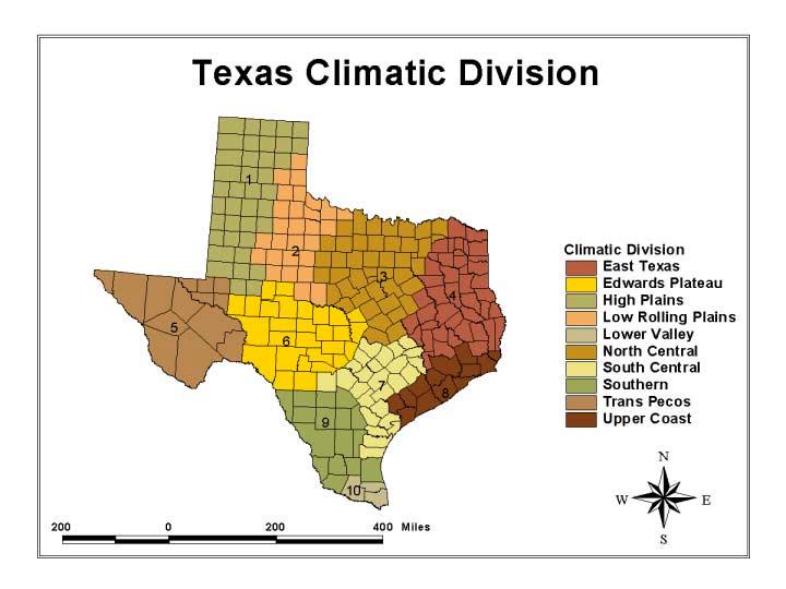
9 Model Development Multiple Linear Regression Model T a = m 1 T s + m 2 T lm T a (max) from 27 weather stations was used for model development T a (max) from 30 weather stations was used for model validation (independent dataset) T s Vs T a (max) relationships has been established for each of the10 climatic zones of Texas

10
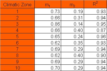
11 Regression Coefficients
12
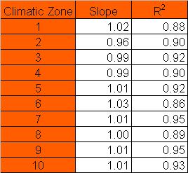
13 Model Validation
14
15 Applications Potential Evapo-Transpiration Soil Moisture Monitoring/ Hydrologic Modeling Drought Indices KBDI PDSI
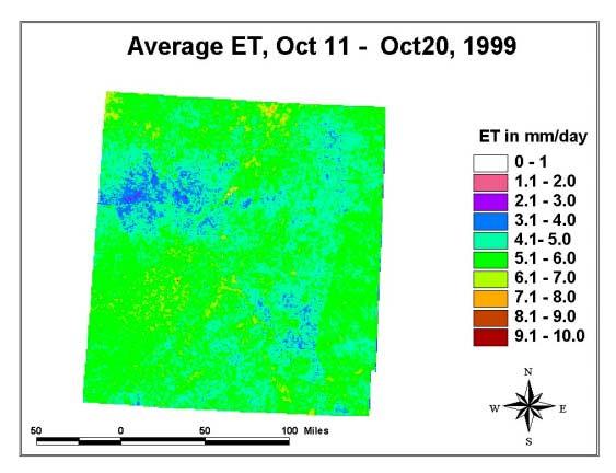
16 Potential Evapo-Transpiration Energy Balance Model R n = λe + H + G Where: R n = net radiation flux (kj.m -2.s -1 ), λe = latent heat flux, H = sensible heat flux to the air, G = sensible heat flux to the soil.
17 Potential Evapo-Transpiration (Contd..) Sensible Heat Flux H = -ρ a.c p.h h.(t a -T s ) Where: H = sensible heat flux (kj.m -2.s -1 ), ρ a = density of air (kg.m -3 ), C p = specific heat of air (kj.kg -1.ºC -1 ), h h = transport coefficient (s.m -1 ), = u 2 /208 (Grass Reference), u 2 = wind velocity(m.s -1 ), T a = air temperature (ºC), T s = land surface temperature (ºC).
18
19 Soil Moisture Monitoring Using a water balance model SWC t = SWC t-1 + ( Precipitation - ET - Runoff ) Precipitation from NEXRAD ET from AVHRR Runoff using SCS curve number technique Useful to calculate: irrigation requirements irrigation scheduling water allocation from reservoir
20 Drought Indices KBDI (Keetch-Byram Drought Index) An index of Forest Fire Potential Uses maximum air temperature and precipitation to indicate fire potential in a scale of 0 to 800 Current scale - county level Max. air temperature from AVHRR Precipitation from NEXRAD with GIS and remote sensing technique the spatial accuracy could be improved to 4km X 4km
21 Drought Indices (contd ) PDSI (Palmer Drought Severity Index) An index of Meteorological / Hydrological / Agricultural Drought Uses a simple water balance model to indicate drought in a scale of -4 to 4. Current scale - climatic division improved water balance model using distributed parameters obtained from GIS and remote sensing data spatial accuracy of 4km X 4km
22 Conclusion Energy fluxes between the land surface and the atmosphere Daily coverage Improved spatial accuracy Good tool for regional scale monitoring Drought monitoring and information system MODIS - Moderate Resolution Imaging Spectroradiometer
23 Questions?
Remote Sensing of Water Resources
 Remote Sensing of Water Resources National Disaster Management Institute Yoomi Hur Climate Change Hydrologic Cycle Hydrologic Indices Soil Moisture Evaportranspiration Drought Conclusions 3 The water cycle
Report on Fire Danger Rating System (FDRS)
") Report on Fire Danger Rating System (FDRS) Orbita Roswintiarti, PhD. Indonesian National Institute of Aeronautics and Space (LAPAN) Presented at the Sentinel Asia Joint Project Team Meeting 2010 Manila,
Report on Fire Danger Rating System (FDRS) Orbita Roswintiarti, PhD. Indonesian National Institute of Aeronautics and Space (LAPAN) Presented at the Sentinel Asia Joint Project Team Meeting 2010 Manila,
Remotely-Sensed Fire Danger Rating System to Support Forest/Land Fire Management in Indonesia
 Remotely-Sensed Fire Danger Rating System to Support Forest/Land Fire Management in Indonesia Orbita Roswintiarti Indonesian National Institute of Aeronautics and Space (LAPAN) SE Asia Regional Research
Evaluating Vegetation Evapotranspiration (VegET) Modeling Results in South Dakota
 Modeling Results in South Dakota") Evaluating Vegetation Evapotranspiration (VegET) Modeling Results in South Dakota Gabriel Senay 1 and Geoffrey Henebry 2 1 SAIC, contractor to the U.S. Geological Survey (USGS) Center for Earth Resources
Evaluating Vegetation Evapotranspiration (VegET) Modeling Results in South Dakota Gabriel Senay 1 and Geoffrey Henebry 2 1 SAIC, contractor to the U.S. Geological Survey (USGS) Center for Earth Resources
Understanding the Impact of Drought on Crop Yield in South and North Carolina
 Understanding the Impact of Drought on Crop Yield in South and North Carolina Junyu Lu, Gregory J. Carbone Department of Geography, University of South Carolina, Columbia Introduction Social& economical
th Conf on Hydrology, 85 th AMS Annual Meeting, 9-13 Jan, 2005, San Diego, CA., USA.
 4.12 19th Conf on Hydrology, 85 th AMS Annual Meeting, 9-13 Jan, 5, San Diego, CA., USA. IMPACT OF DEFORESTATION ON THE PROPOSED MESOAMERICAN BIOLOGICAL CORRIDOR IN CENTRAL AMERICA Ronald M Welch 1, Deepak
Water balance in soil
 Technische Universität München Water balance Water balance in soil Arno Rein Infiltration = + precipitation P evapotranspiration ET surface runoff Summer course Modeling of Plant Uptake, DTU Wednesday,
Evaluation of Indices for an Agricultural Drought Monitoring System in Arid and Semi-Arid Regions
 Evaluation of Indices for an Agricultural Drought Monitoring System in Arid and Semi-Arid Regions Alireza Shahabfar, Josef Eitzinger Institute of Meteorology, University of Natural Resources and Life Sciences
National Drought Monitoring in Canada
 National Drought Monitoring in Canada Trevor Hadwen Agriculture and Agri-Food Canada, Agri-Environmental Services Branch (AESB) National Agroclimate Information Service (NAIS) Manitoba, DRI Workshop Winnipeg,
MODULE 8 LECTURE NOTES 5 REMOTE SENSING APPLICATIONS IN DROUGHT ASSESSMENT
 MODULE 8 LECTURE NOTES 5 REMOTE SENSING APPLICATIONS IN DROUGHT ASSESSMENT 1. Introduction Drought is a phenomenon of long-term moisture deficiency. It may be meteorological, agricultural or hydrologic
POTENTIALS FOR DETECTING CANOPY WATER STRESS USING GEOSTATIONARY MSG-SEVIRI SWIR DATA
 POTENTIALS FOR DETECTING CANOPY WATER STRESS USING GEOSTATIONARY MSG-SEVIRI SWIR DATA Rasmus Fensholt, *Department of Geography and Geology, University of Copenhagen, Denmark Co-workers; Silvia Huber*,
The role of Remote Sensing in Irrigation Monitoring and Management. Mutlu Ozdogan
 The role of Remote Sensing in Irrigation Monitoring and Management Mutlu Ozdogan Outline Why do we care about irrigation? Remote sensing for irrigated agriculture What are the needs of irrigators? Future
Analysis of drought characteristics from 1880s to 2012 for an improved understanding of a water resource system
 Analysis of drought characteristics from 1880s to 2012 for an improved understanding of a water resource system Amy Lennard 1 & Sarah Clark 2 1 University of Liverpool, School of Environmental Sciences
Full terms and conditions of use:
 This article was downloaded by:[george Mason University] [George Mason University] On: 26 March 2007 Access Details: [subscription number 768492716] Publisher: Taylor & Francis Informa Ltd Registered in
Hydrologic Modeling of Cedar Creek Watershed using SWAT
 North Central Texas Water Quality Project Hydrologic Modeling of Cedar Creek Watershed using SWAT Balaji Narasimhan, Raghavan Srinivasan, Steve Bernardz and Mark Ernst Cedar Creek Reservoir Total Watershed
Drought monitoring and early warning indicators as tools for climate change adaptation
 Drought monitoring and early warning indicators as tools for climate change adaptation Lučka Kajfež Bogataj, University of Ljubljana, Slovenia Integrated Drought Management Programme in Central and Eastern
CROP STATE MONITORING USING SATELLITE REMOTE SENSING IN ROMANIA
 CROP STATE MONITORING USING SATELLITE REMOTE SENSING IN ROMANIA Dr. Gheorghe Stancalie National Meteorological Administration Bucharest, Romania Content Introduction Earth Observation (EO) data Drought
The Science Behind Measuring Depletions
 The Science Behind Measuring Depletions 1 The Science Behind Measuring Depletions Salim Bawazir, New Mexico State University Salim Bawazir is Associate Professor in the Civil Engineering (CE) Department
Estimating Groundwater Recharge within Wisconsin s Central Sands
 Estimating Groundwater Recharge within Wisconsin s Central Sands Adam Freihoefer and Robert Smail Wisconsin Department of Natural Resources [study objective] Identify a defensible approach to quantify
Hydrological Threats to Ecosystem Services Provided by USDA Forest Service
 Hydrological Threats to Ecosystem Services Provided by USDA Forest Service Yongqiang Liu Center for Forest Disturbance Science USDA Forest Service, Athens, GA, USA International Symposium on Synergistic
BAEN 673 / February 18, 2016 Hydrologic Processes
 BAEN 673 / February 18, 2016 Hydrologic Processes Assignment: HW#7 Next class lecture in AEPM 104 Today s topics SWAT exercise #2 The SWAT model review paper Hydrologic processes The Hydrologic Processes
Mixing Up a Drought Indicator Cocktail, Blended, not Stirred: A Combined Drought Indicator Approach
 Mixing Up a Drought Indicator Cocktail, Blended, not Stirred: A Combined Drought Indicator Approach Mark Svoboda, Ph.D., Director and Brian Fuchs, Monitoring Program Area Leader National Drought Mitigation
The Spatial Analysis between SWAT Simulated Soil Moisture, and MODIS LST and NDVI Products
 Konkuk University, Seoul, South Korea The Spatial Analysis between SWAT Simulated Soil Moisture, and MODIS LST and NDVI Products Geun Ae PARK Post-doctoral Researcher, Dept. of Civil and Environmental
Potential uses of Indices (PDSI,CMI) and other Indicators to estimate drought in Barbados. Presented by: Shontelle Stoute
 and other Indicators to estimate drought in Barbados. Presented by: Shontelle Stoute") Potential uses of Indices (PDSI,CMI) and other Indicators to estimate drought in Barbados Presented by: Shontelle Stoute What is drought? Insufficient quantity of water, relative to what is normal, to
Potential uses of Indices (PDSI,CMI) and other Indicators to estimate drought in Barbados Presented by: Shontelle Stoute What is drought? Insufficient quantity of water, relative to what is normal, to
August 6, Min-Ji Park, Hyung-Jin Shin, Jong-Yoon Park Graduate Student. Geun-Ae Park. Seong-Joon Kim
 Comparison of Watershed Streamflow by Using the Projected MIROC3.2hires GCM Data and the Observed Weather Data for the Period of 2000-2009 under SWAT Simulation August 6, 2010 Min-Ji Park, Hyung-Jin Shin,
Prof. D. Nagesh Kumar Drs A Anandhi, V V Srinivas & Prof Ravi S Nanjundiah
 Prof. D. Nagesh Kumar Department of Civil Engineering Indian Institute of Science Bangalore 560012 URL: http://www.civil.iisc.ernet.in/~nagesh Acknowledgement: Drs A Anandhi, V V Srinivas & Prof Ravi S
Numerical Modeling of Thermal Bar Evolution in Lake Ontario using the EFDC Model Rumana Reaz Arifin
 Numerical Modeling of Thermal Bar Evolution in Lake Ontario using the EFDC Model Rumana Reaz Arifin 14 th Great Lakes Beach Association Conference November 14, 2014 Layout Introduction EFDC Lake Ontario
Recent increased frequency of drought events in Poyang Lake Basin, China: climate change or anthropogenic effects?
 Hydro-climatology: Variability and Change (Proceedings of symposium J-H02 held during IUGG2011 in Melbourne, Australia, July 2011) (IAHS Publ. 344, 2011). 99 Recent increased frequency of drought events
VEGETATION AND SOIL MOISTURE ASSESSMENTS BASED ON MODIS DATA TO SUPPORT REGIONAL DROUGHT MONITORING
 University of Szeged Faculty of Science and Informatics Department of Physical Geography and Geoinformatics http://www.geo.u-szeged.hu kovacsf@geo.u-szeged.hu Satellite products for drought monitoring
Energy Balance and Evapotranspiration Measurement
 Energy Balance and Evapotranspiration Measurement Yu-Jun Cui Ecole Nationale des Ponts et Chaussée, Paris, France Jorge G. Zornberg The University of Texas at Austin, USA ABOUT THIS TOPIC - Multi-disciplinary
VEGETATION AND SOIL MOISTURE ASSESSMENTS BASED ON MODIS DATA TO SUPPORT REGIONAL DROUGHT MONITORING
 University of Szeged Faculty of Science and Informatics Department of Physical Geography and Geoinformatics http://www.geo.u-szeged.hu kovacsf@geo.u-szeged.hu Satellite products for drought monitoring
STUDY ON SOIL MOISTURE BY THERMAL INFRARED DATA
 THERMAL SCIENCE, Year 2013, Vol. 17, No. 5, pp. 1375-1381 1375 STUDY ON SOIL MOISTURE BY THERMAL INFRARED DATA by Jun HE a, Xiao-Hua YANG a*, Shi-Feng HUANG b, Chong-Li DI a, and Ying MEI a a School of
Extending the societal and economic benefits of Earth science research, information, and technology
 NASA WATER SCIENCE & APPLICATIONS NASA S APPLIED SCIENCES PROGRAM Steven Ambrose 1, Jared Entin 2, David Toll 3 and Ted Engman 4 1- Applied Sciences Program, NASA/HQ 2-TerrestrialHydrology Program & NASA
Water Science and the Environment
 Water Science and the Environment HWRS 201 Dr. Zreda Mr. Ghasemian Fall 2015 Surface Evaporation: Overview Evaporation is a process that transfers energy from the Earth s surface to the atmosphere. Some
Module 9 (L35 L37): Drought Management : Drought assessment and classification, drought. 36 Drought Analysis
: Drought Management : Drought assessment and classification, drought. 36 Drought Analysis") Module 9 (L35 L37): Drought Management : Drought assessment and classification, drought analysis techniques, drought mitigation planning. 36 Drought Analysis 1 1 L36 L36 Drought Analysis Topics Covered
Module 9 (L35 L37): Drought Management : Drought assessment and classification, drought analysis techniques, drought mitigation planning. 36 Drought Analysis 1 1 L36 L36 Drought Analysis Topics Covered
Zhigang Sun, 1,2 Qinxue Wang, 3 Ochirbat Batkhishig, 4 and Zhu Ouyang 1,2. 1. Introduction
 Advances in Meteorology Volume 216, Article ID 1835487, 9 pages http://dx.doi.org/1.1155/216/1835487 Research Article Relationship between Evapotranspiration and Land Surface Temperature under Energy-
Research and Applications using Realtime Direct Broadcast Imagery, Weather Radar, and LiDAR in Disaster Response and Preparedness
 Research and Applications using Realtime Direct Broadcast Imagery, Weather Radar, and LiDAR in Disaster Response and Preparedness Richard P. Watson, Ph.D. University of New Mexico Earth Data Analysis Center
Agricultural drought index and monitoring on national scale. LU Houquan National Meteorological Center, CMA
 Agricultural drought index and monitoring on national scale LU Houquan National Meteorological Center, CMA Contents Agricultural drought disasters in China Agricultural drought indices --Precipitation
Map Asia Conference 2009
 Monitoring Regional Evapotranspiration Using SEBAL Approach and MODIS Time-Series Data in the Center of Rice Producing Regions in West Java Indonesia Dewi Kania Sari 1,2 Ishak H. Ismullah 1, Widyo Nugroho
Remote Sensing of Land & Vegetation. C S Murthy
 Remote Sensing of Land & Vegetation C S Murthy Remote Sensing current status New era of RS in 21 st Century Increased utilisation of data Quantitative algorithms/improved retrieval methods Better calibrations
Remote Sensing Application for Estimation of Irrigation Water Consumption in Liuyuankou Irrigation System in China
 Remote Sensing Application for Estimation of Irrigation Water Consumption in Liuyuankou Irrigation System in China Hafeez, M. 1 and S. Khan 1, 2 1 CSIRO Land and Water Division, mohsin.hafeez@csiro.au
Estimating Evapotranspiration of Paddy Field and Teak Plantation Using Remote Sensing
 Kasetsart J. (Nat. Sci.) 41 : 798-810 (2007) Estimating Evapotranspiration of Paddy Field and Teak Plantation Using Remote Sensing Piyapong Tongdeenok 1 *, Samakkee Boonyawat 1 and Kankhajane Chuchip 2
WIDE-SCALE MODELLING OF WATER AND WATER AVAILABILITY WITH EARTH OBSERVATION/SATELLITE IMAGERY
 WIDE-SCALE MODELLING OF WATER AND WATER AVAILABILITY WITH EARTH OBSERVATION/SATELLITE IMAGERY Ferreira F 1, Goudriaan R 2, Gibson LA 3, Jarmain C 4, Kemp JN 6, Mashimbye E 5, Münch Z 6, Pauw T 6, Stephenson
The Hydrosphere: Lecture 7: Evapotranspiration. Paul R. Houser,27 March 2012, Page 1
 The Hydrosphere: Lecture 7: Evapotranspiration Paul R. Houser,27 March 2012, Page 1 Evapotranspiration evapotranspiration summarizes all processes that return liquid water back into water vapor evaporation
Applications of Satellite Remote Sensing and Ground -based Observations in Monitoring Lakes and Urban Surface Temperature
 Applications of Satellite Remote Sensing and Ground -based Observations in Monitoring Lakes and Urban Surface Temperature Hamid Norouzi, PhD, PE New York City College of Technology, CUNY The Graduate Center,
Mountain hydrology of the semi-arid western U.S.: Research needs, opportunities & challenges
 Mountain hydrology of the semi-arid western U.S.: Research needs, opportunities & challenges Roger Bales 1, Jeff Dozier 2, Noah Molotch 3, Tom Painter 3, Bob Rice 1 1 UC Merced. 2 UC Santa Barbara, 3 U
Optimizing crop water consumption using ET maps in GIS CEE6640 Term Paper Leila Esfahani
 Introduction Optimizing crop water consumption using ET maps in GIS CEE6640 Term Paper Leila Esfahani Water is essential for crop production, and any shortage has an impact on final yields. Since farmers
LARGE SCALE SOIL MOISTURE MODELLING
 Soil Moisture Workshop LARGE SCALE SOIL MOISTURE MODELLING Giuseppe Formetta, Vicky Bell, and Eleanor Blyth giufor@nerc.ac.uk Centre for Ecology and Hydrology, Wallingford, UK Wednesday 25 th January 2017
Time Series Evapotranspiration and Applied Water Estimates from Remote Sensing
 Applied Water Estimates from Remote Sensing Prepared By March 213 Contents Kaweah Delta Water Conservation District Time Series Evapotranspiration and Applied Water Estimates from Remote Sensing Contents
SOIL MOISTURE RETRIEVAL FROM OPTICAL AND THERMAL SPACEBORNE REMOTE SENSING
 Comm. Appl. Biol. Sci, Ghent University, 70/2, 2005 1 SOIL MOISTURE RETRIEVAL FROM OPTICAL AND THERMAL SPACEBORNE REMOTE SENSING W.W. VERSTRAETEN 1,2 ; F. VEROUSTRAETE 2 ; J. FEYEN 1 1 Laboratory of Soil
Expert Meeting on Crop Monitoring for Improved Food Security, 17 February 2014, Vientiane, Lao PDR. By: Scientific Context
 Satellite Based Crop Monitoring & Estimation System for Food Security Application in Bangladesh Expert Meeting on Crop Monitoring for Improved Food Security, 17 February 2014, Vientiane, Lao PDR By: Bangladesh
Measurement of Evapotranspiration Across Different Land Cover Types in the Greater Toronto Area
 Measurement of Evapotranspiration Across Different Land Cover Types in the Greater Toronto Area Prepared by: Toronto and Region Conservation and York University 2014 MEASUREMENT OF EVAPOTRANSPIRATION
Figure 1. Location of research sites in the Ameriflux network (from Ameriflux web site,
 CONTEXT - AMERIFLUX NETWORK Figure 1. Location of research sites in the Ameriflux network (from Ameriflux web site, http://public.ornl.gov/ameriflux/). AMERIFLUX OBJECTIVES: Quantify spatial and temporal
Temporal trends of mercury in precipitation from the Mercury Deposition Network:
 Temporal trends of mercury in precipitation from the Mercury Deposition Network: 2008-2015 Connections with the Palmer Drought Severity Index Peter Weiss-Penzias University of California, Santa Cruz David
Mapping Water Use and Drought with Satellite Remote Sensing
 Xiwu Zhan NOAA-NESDIS-STAR Jason Otkin University of Wisconsin Mapping Water Use and Drought with Satellite Remote Sensing Christopher Hain NASA-MSFC Li Fang, Mitch Schull Earth System Science Interdisciplinary
Winter Wheat Drought Monitoring and Comprehensive Risk Assessment: Case Study of Xingtai Administrative District in North China
 Journal of Environmental Science and Engineering A 6 (2017) 135-143 doi:10.17265/2162-5298/2017.03.004 D DAVID PUBLISHING Winter Wheat Drought Monitoring and Comprehensive Risk Assessment: Case Study of
Overview of US Activities Related to Remote Sensing of Temperatures of Inland Waters
 Overview of US Activities Related to Remote Sensing of Temperatures of Inland Waters Simon J. Hook Philipp Schneider Robert G. Radocinski Robert C. Wilson and many others at other institutions: RIT, UCD
Climate change impacts on water resources in the Upper Po basin
 limate change impacts on water resources in the Upper Po basin Giovanni Ravazzani, Marco Mancini, hiara orbari, Alessandro eppi, Laura Boscarello, Giulia Ercolani Department of ivil and Environmental Engineering
Modelling the spatial variability of the snowcover and the surface energy fluxes at TVC. S. Endrizzi, P. Marsh, and S. Pohl
 Modelling the spatial variability of the snowcover and the surface energy fluxes at TVC S. Endrizzi, P. Marsh, and S. Pohl Purpose of Study Study the effects of topography and land cover on snow cover
To provide timely, accurate, and useful statistics in service to U.S. agriculture
 NASS MISSION: To provide timely, accurate, and useful statistics in service to U.S. agriculture What does NASS do? Administer USDA s Statistical Estimating Program Conduct the 5-year Census of Agriculture
Using Remotely Sensed Tools for Combined Drought Indicators to Enhance Drought Early Warning for Decision Support
 Using Remotely Sensed Tools for Combined Drought Indicators to Enhance Drought Early Warning for Decision Support MARK SVOBODA, PH.D., DIRECTOR NATIONAL DROUGHT MITIGATION CENTER UNIVERSITY OF NEBRASKA-LINCOLN
3/1/18 USING RADAR FOR WETLAND MAPPING IMPORTANCE OF SOIL MOISTURE TRADITIONAL METHODS TO MEASURE SOIL MOISTURE. Feel method Electrical resistance
 3/1/18 USING RADAR FOR WETLAND MAPPING SOIL MOISTURE AND WETLAND CLASSIFICATION Slides modified from a presentation by Charlotte Gabrielsen for this class. Southeast Arizona: Winter wet period From C.
Research on evaporation of Taiyuan basin area by using remote sensing
 Hydrol. Earth Syst. Sci. Discuss., 2, 9 227, www.copernicus.org/egu/hess/hessd/2/9/ SRef-ID: 1812-2116/hessd/-2-9 European Geosciences Union Hydrology and Earth System Sciences Discussions Research on
Drought Decision-Support Tools: Introducing the Keetch Byram Drought Index KBDI 1
 AE471 Drought Decision-Support Tools: Introducing the Keetch Byram Drought Index KBDI 1 Clyde W. Fraisse, Norman E. Breuer, and David Zierden 2 Introduction Agriculture is inherently risky. Drought is
Drought Decision-Support Tools: Introducing the Keetch Byram Drought Index KBDI 1
 AE471 Drought Decision-Support Tools: Introducing the Keetch Byram Drought Index KBDI 1 Clyde W. Fraisse, Norman E. Breuer, and David Zierden 2 Introduction Agriculture is inherently risky. Drought is
Remote Sensing of Soil Moisture. Lecture 20 Nov. 7, 2005
 Remote Sensing of Soil Moisture Lecture 20 Nov. 7, 2005 What is soil moisture? Is defined as the ratio of liquid water content to the soil in percentage of volume or weight, is an inheritage and memory
Effects of Land Use On Climate and Water Resources: Application of a Land Surface Model for Land Use Management
 Effects of Land Use On Climate and Water Resources: Application of a Land Surface Model for Land Use Management Gordon Bonan, PI National Center for Atmospheric Research Boulder, Colorado Personnel Supported:
Forest change detection in boreal regions using
 Forest change detection in boreal regions using MODIS data time series Peter Potapov, Matthew C. Hansen Geographic Information Science Center of Excellence, South Dakota State University Data from the
Figure 1 Examples of recent environmental disasters in the Asia-Pacific region
 1. What is APEIS-IEM? 1.1 Objectives Environmental Conditions are deteriorating in the Asia-Pacific region, home to about 60 percent of the world s population and currently experiencing rapid population
IOP Conference Series: Earth and Environmental Science. Related content OPEN ACCESS
 IOP Conference Series: Earth and Environmental Science OPEN ACCESS Indonesian drought monitoring from space. A report of SAFE activity: Assessment of drought impact on rice production in Indonesia by satellite
Draft White Paper on Total Water Use. Submitted to: Buena Vista Water Storage District
 Draft White Paper on Total Water Use Submitted to: Buena Vista Water Storage District Date: February 2016 Table of Contents 1.0 Introduction 2 2.0 Role of Accounting for Total Water Use in SGMA 2 2.1 Consumptive
The impact of high resolution soil on surface fluxes in JULES
 The impact of high resolution soil on surface fluxes in JULES Heather Ashton, Richard Gilham, Martin Best JULES Annual Science Meeting 2016 28 th - 29 th June, Lancaster Environment Centre Outline Motivations
Texas A & M University and U.S. Bureau of Reclamation Hydrologic Modeling Inventory Model Description Form
 Texas A & M University and U.S. Bureau of Reclamation Hydrologic Modeling Inventory Model Description Form JUNE 18, 1999 Name of Model: MIKE 11 RR (Rainfall Runoff) Model Type: The MIKE 11 RR model is
Issues include coverage gaps, delays, measurement continuity and consistency, data format and QC, political restrictions
 Satellite-based Estimates of Groundwater Depletion, Ph.D. Chief, Hydrological Sciences Laboratory NASA Goddard Space Flight Center Greenbelt, MD Groundwater Monitoring Inadequacy of Surface Observations
Adaption to climate change: New technologies for water management and impact assessment
 Adaption to climate change: New technologies for water management and impact assessment Wim Bastiaanssen Director WaterWatch (NL) Professor at Delft University of Technology (NL) Some selected problems
Progress and prospects for soil moisture monitoring and applications in Oklahoma and beyond
 Progress and prospects for soil moisture monitoring and applications in Oklahoma and beyond Tyson Ochsner Dep. of Plant and Soil Sciences Oklahoma State University Presented at: Oklahoma NSF EPSCoR 2018
The Hydrologic Cycle. October 7, 2010
 The Hydrologic Cycle October 7, 2010 Why do we care about the hydrologic cycle? The amount of water that flows through the hydrologic cycle each year is equal to about a 1 m depth of water averaged over
Assessment of Surface Energy Balance in Southern Idaho
 Assessment of Surface Energy Balance in Southern Idaho Beda Luitel: McNair Scholar Dr. Venkat Sridhar: Mentor Civil Engineering Abstract Proper management of water resources is always a matter of concern
Monitoring, Assessment, Prediction and Meteorological service of Agricultural Drought in China
 Monitoring, Assessment, Prediction and Meteorological service of Agricultural Drought in China Wang Shili China Meteorological Administration January, 2005, Kobe Content Characteristics of agrometerological
On SEBI-SEBS validation in France, Italy, Spain, USA and China
 On SEBI-SEBS validation in France, Italy, Spain, USA and China Massimo Menenti Li Jia 2 and ZongBo Su 2 - Laboratoire des Sciences de l Image, de l Informatique et de la Télédétection (LSIIT), Strasbourg,
LMWG Development Activities
 LMWG Development Activities Hydrology: resolve upper-soil moisture variability issue Snow: SCF, SBF, snow age, vertically resolved heating Urban model Fine mesh high resolution land and downscaling Integration
Integrated Early-Warning Monitoring and Forecasting: Data Products
 Integrated Early-Warning Monitoring and Forecasting: Data Products John J. Qu, Xianjun Hao & Lingli Wang jqu@gmu.edu Environmental Science & Technology Center (ESTC) College of Science George Mason University
Need Additional Information? LEGAL DISCLAIMER ACKNOWLEDGEMENT:
 LEGAL DISCLAIMER This work was implemented as part of the CGIAR Research Program on Climate Change, Agriculture and Food Security (CCAFS) hosted by BISA-CIMMYT in South Asia. The views expressed in this
Use of GIS and Remote Sensing to assess Soil Erosion in Arid to Semiarid Basin in Jordan
 Use of GIS and Remote Sensing to assess Soil Erosion in Arid to Semiarid Basin in Jordan Ibrahim Farhan and Jawad Al Bakri Dept. Land, Water & Env. Faculty of Agriculture, University of Jordan, Amman,
Air Quality Issues in Vermont Rich Poirot, Air Quality and Climate Division, VT DEC
 Air Quality Issues in Vermont Rich Poirot, Air Quality and Climate Division, VT DEC Burlington, VT on 5/25/07 PM 2.5 = 38 ug/m 3 8-hr Ozone = 0.087 ppm Slide from talk on CASAC Ozone NAAQS Review, OTC
Using Satellite Imagery to Measure Evaporation from Storages- Solving the Great Unknown in Water Accounting
 - Solving the Great Unknown in Water Accounting Richard Evans 1, Erin Murrihy1, Wim Bastiaanssen 2 and Robert Molloy 1 1- Sinclair Knight Merz, 2- WaterWatch Corresponding Author: Erin Murrihy, Hydrologist
CIVE 641 Advanced Surface Water Hydrology. Term Project Report. Continuous Simulation of DPHM-RS for Blue River Basin
 CIVE 641 Advanced Surface Water Hydrology Term Project Report Continuous Simulation of DPHM-RS for Blue River Basin Submitted to T.Y. Gan, PhD, FASCE Professor, Dept. of Civil and Environmental Engineering
GIS Framework to Evaluate Impact of Climate Change on Water Resources
 GIS Framework to Evaluate Impact of Climate Change on Water Resources Dr. Nagraj S. Patil A. K. Gosain, Professor Civil Engineering Department I. I. T. Delhi Objectives of the Study To Develop portal to
A dissertation submitted in partial fulfillment of the requirements for the degree of Doctor of Philosophy at George Mason University
 Remote Sensing Techniques for Soil Moisture and Agricultural Drought Monitoring A dissertation submitted in partial fulfillment of the requirements for the degree of Doctor of Philosophy at George Mason
Title: The Impact of Drought on Vegetation Water Use in Different Climatic Divisions across Oklahoma
 Title: The Impact of Drought on Vegetation Water Use in Different Climatic Divisions across Oklahoma Authors Names and Affiliations: Kul Khand 1, Saleh Taghvaeian 2, Prasanna Gowda 3 1 PhD Student; Department
Plant Breeding for Stress Tolerance Part 1: Consider the Energy Balance
 Plant Breeding for Stress Tolerance Part 1: Consider the Energy Balance James L. Heilman and Kevin J. McInnes Dept. of Soil and Crop Sciences High throughput phenotyping is a promising methodology for
Figure 1: Schematic of water fluxes and various hydrologic components in the vadose zone (Šimůnek and van Genuchten, 2006).
.") The evapotranspiration process Evapotranspiration (ET) is the process by which water is transported from the earth surface (i.e., the plant-soil system) to the atmosphere by evaporation (E) from surfaces
The evapotranspiration process Evapotranspiration (ET) is the process by which water is transported from the earth surface (i.e., the plant-soil system) to the atmosphere by evaporation (E) from surfaces
LAND AND WATER - EARTH OBSERVATION INFORMATICS FSP
 Earth Observation for Water Resources Management Arnold Dekker,Juan P Guerschman, Randall Donohue, Tom Van Niel, Luigi Renzullo,, Tim Malthus, Tim McVicar and Albert Van Dijk LAND AND WATER - EARTH OBSERVATION
Lecture 5: Transpiration
 5-1 GEOG415 Lecture 5: Transpiration Transpiration loss of water from stomatal opening substomatal cavity chloroplasts cuticle epidermis mesophyll cells CO 2 H 2 O guard cell Evaporation + Transpiration
The Effects of Agricultural Expansion on Regional Hydrology in Southeastern Turkey
 The Effects of Agricultural Expansion on Regional Hydrology in Southeastern Turkey Principal Investigator: Guido D. Salvucci gdsalvuc@bu.edu Telephone: 617-353-8344 Co-Investigators: Name e-mail Telephone
Water Data and Modeling Services
 Water Data and Modeling Services Presented by: Fernando Salas 1 and Cindy Hooper 2 1 Center for Research in Water Resources University of Texas at Austin 2 Texas Commission on Environmental Quality October
geoland HALO Workshop Issue I.1.00 Observatory of Natural Carbon fluxes Jean-Christophe Calvet and the geoland / ONC Team
 Observatory of Natural Carbon fluxes HALO Workshop Issue I.1.00 Jean-Christophe Calvet and the / ONC Team November 2004 ONC overview ONC tools ONC implementation ONC first results Conclusions November
7KH3UHGLFWLRQ0HWKRGRI:DWHU 7HPSHUDWXUHLQ'LVWULEXWLRQ3LSHV
 7KH3UHGLFWLRQHWKRGRI:DWHU 7HPSHUDWXUHLQ'LVWULEXWLRQ3LSHV 'U.6DNDXH'U.DPDWD'U6,ZDPRWR'U +1LPL\D (1) 6DNDXH#LVFPHLMLDFMS Dept. of Architecture, School of Science and Technology, Meiji University, Japan.
Diffuse Attenuation Coefficient of the Photosynthetically Available Radiation (PAR), K d (PAR), for Global Open Ocean and Coastal Waters
, K d (PAR), for Global Open Ocean and Coastal Waters") Diffuse Attenuation Coefficient of the Photosynthetically Available Radiation (PAR), K d (PAR), for Global Open Ocean and Coastal Waters SeungHyun Son 1,2 and Menghua Wang 1 1 NOAA/NESDIS/STAR, E/RA3,
Diffuse Attenuation Coefficient of the Photosynthetically Available Radiation (PAR), K d (PAR), for Global Open Ocean and Coastal Waters SeungHyun Son 1,2 and Menghua Wang 1 1 NOAA/NESDIS/STAR, E/RA3,
Assessing the hydrological impacts of climate change at the local scale: Dynamical coupling of a regional climate model to a hydrological model
 Assessing the hydrological impacts of climate change at the local scale: Dynamical coupling of a regional climate model to a hydrological model Martin Drews 1, Søren H. Rasmussen 1, Jens Hesselbjerg Christensen