Dr Kasper Johansen & Tri Raharjo Remote Sensing Research Centre The University of Queensland
|
|
|
- Roland Warner
- 6 years ago
- Views:
Transcription


1 Pre- and Post-Pruning Assessment of Lychee Tree Crop Structure Using Multi-Spectral RPAS Imagery Dr Kasper Johansen & Tri Raharjo Remote Sensing Research Centre The University of Queensland 1
2 Outline 1. Introduction and Objectives 2. Study Area 3. Data 4. Methods 5. Results 6. Conclusions and Future Work 2

3 1. Introduction Tropical tree native to China, producing small fleshy fruit. China and India account for > 80% of total production. Lychee production in Australia worth > $20m annually. Australian lychees in northern hemisphere off-season. 3
4 1. Introduction Pruning of trees: encourages new growth; has a positive effect on fruiting of lychee; makes fruit-picking easier; and increases yield, as it increases light interception and tree crown surface area. Objectives: to assess changes in tree structure (tree crown height, area, circumference and width, and plant projective cover) using multi-spectral RPAS imagery collected before and after pruning of a lychee plantation; and to assess any variations in the results as a function of three different flying heights. 4


5 2. Study Area Shailer Park, QLD Shailer Park located 25 km southeast of Brisbane Site context 5


6 2. Study Area Shailer Park, QLD Shailer Park located 25 km southeast of Brisbane 6

 3.")
7 Green, Red, Red Edge, NIR bands 11 Feb 2017 (prepruning 4 March 2017 (postpruning) 3. RPAS Data 7


8 3. RPAS Data Tower Beta app, 80% overlap, 1 photo / sec, 5 m/s 30 m = 4.1 cm pixels, 50 m = 6.5 cm pixels, 70 m = 8.8 cm pixels 8


9 3. Field Data 9


10 3. Field Data 89 trees sampled, 4 March Tree height Tree crown circumference Tree crown width Plant projective crown cover 78.25% 10


11 4. Methods Image Processing Generation of geometrically corrected orthomosaics, DSM and DTM in Pix4D Mapper 11 February March 2017 DSM DTM Meters 11

12 4. Methods Radiometric Correction 12


13 4. Methods Radiometric Correction Green Red Red Edge NIR 13
14 4. Methods Radiometric Correction 14


15 4. Methods GEOBIA 50 m 50 m Map lychee tree extent CHM and spectral info Identify tree crown centres Grow tree crown centres based on CHM Adjust shape and tree crown dimensions 15

16 4. Methods RPAS Derived Tree Crown Parameter Extraction Spectral Information: Green, Red, Red Edge, NIR; Brightness, NIR+Red Edge, NDRE, NDVI Height Information: Average CHM, Max CHM, 90 Percentile per tree crown Geometry: Area, Perimeter length, Length, Width Texture: GLCM Homogeneity, Contrast, Dissimilarity, Standard deviation using the Green, Red, Red Edge and NIR bands 16


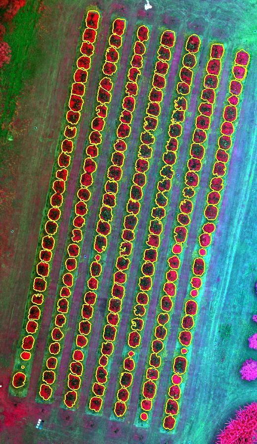
17 5. Results Tree Crown Delineation 50 m 17


18 5. Results Tree Crown Perimeter RMSE = 4.57 m RMSE = 3.63 m RMSE = 3.42 m 18
19 5. Results Tree Crown Width Similar results for all flying heights Measurements of tree crown width not affected by pixel size 19
20 5. Results Tree Crown Height The DTM had higher elevation (up to 60 cm) in some locations for the data set collected at 70 m The DSM showed a lowering of relative height of features above ground with increasing flying height. 20

21 5. Results Plant Projective Cover RedEdge and NIR bands produced highest correlation Very low correlation between red band and PPC Texture explains some variation in PPC 21
22 5. Results Plant Projective Cover NDVI insensitive to PPC variation due to red band Brightness under- and Red Edge over-estimated PPC 22
23 5. Results Pre- and Post Pruning NIR used to predict PPC for 11 Feb 2017 (pre-pruning) An average of 14.8% decrease in PPC, using the two data sets collected at 30 m height. Smaller trees not pruned 23
24 5. Results Pre- and Post Pruning Height differences based DTM and DSM quality An average of 61.6 cm decrease in height, using the two data sets collected at 30 m height. Smaller trees not pruned 24
25 5. Results Pre- and Post Pruning Area differences based on quality of tree crown delineation An average of 3.5 m 2 decrease in area, using the two data sets collected at 30 m height Smaller trees not pruned and showed slight area increase 25
26 5. Results Pre- and Post Pruning Perimeter differences based on quality of tree crown delineation An average of 1.94 m decrease in perimeter, using the two data sets collected at 30 m height Smaller trees not pruned and showed slight increase 26
27 5. Results Pre- and Post Pruning Tree crown dimension differences based on quality of tree crown delineation An average of 65.3 cm decrease in length, using the two data sets collected at 30 m height Smaller trees not pruned and showed slight increase 27
28 5. Results Pre- and Post Pruning Tree crown dimension differences based on quality of tree crown delineation An average of 56.7 cm decrease in width, using the two data sets collected at 30 m height Smaller trees not pruned and showed slight increase 28

29 5. Results Pre- and Post Pruning Difference between 30 m, 50 m and 70 m flying height Plant Projective Cover, n = 89 29

30 5. Results Pre- and Post Pruning Average differences between 30 m, 50 m and 70 m flying height Height, Area, Perimeter, Length and Width, n = 89 30
31 6. Conclusions ecognition Developer could be used to map individual lychee tree crowns The Sequoia image data were found suitable for assessing pre- and post-pruned tree crown structure: Plant projective cover (best predicted with NIR band) Tree height (most accurately mapped at 30 m height) Tree crown perimeter, area, and dimensions Tree crown perimeter most accurately mapped at 70 m Tree crown width and length similar for all flying heights PPC accurately predicted at all three flying heights, although data collected at 70 m produced slightly higher correlation for most predictor variables. The developed approach may be used to assess pruning efforts undertaken by contractors 31
32 Pre- and Post-Pruning Assessment of Lychee Tree Crop Structure Using Multi-Spectral RPAS Imagery Dr Kasper Johansen & Tri Raharjo Remote Sensing Research Centre The University of Queensland 32
Monitoring Condition of Savanna Riparian Zones in North Australia
 Monitoring Condition of Savanna Riparian Zones in North Australia Centre for Remote Sensing and Spatial Information Science Kasper Johansen Centre for Remote Sensing and Spatial Information Science School
ASSESSING THE STRUCTURE OF DEGRADED FOREST USING UAV
 ASSESSING THE STRUCTURE OF DEGRADED FOREST USING UAV STUDY CASE IN YUNGAS CLOUD FOREST, NORTH ARGENTINA Fernando Rossi 1, Andreas Fritz 2, Gero Becker 1, Barbara Koch 2 Albert-Ludwigs-Universität Freiburg
Measuring canopy structure and condition using multi-spectral UAS imagery in a horticultural environment
 Article Measuring canopy structure and condition using multi-spectral UAS imagery in a horticultural environment Yu-Hsuan Tu 1, *, Kasper Johansen 2, Stuart Phinn 1, and Andrew Robson 3 1 Remote Sensing
REMOTE SENSING: DISRUPTIVE TECHNOLOGY IN AGRICULTURE? DIPAK PAUDYAL
 Place image here (13.33 x 3.5 ) REMOTE SENSING: DISRUPTIVE TECHNOLOGY IN AGRICULTURE? DIPAK PAUDYAL Principal Consultant, Remote Sensing- Esri Australia Adjunct Associate Prof., University of Queensland
Fruit load estimation in mango orchards a method comparison
 Fruit load estimation in mango orchards a method comparison J. P. Underwood 1, M.M. Rahman 2, A. Robson 2, K. B. Walsh 3, A. Koirala 3, Z. Wang 3 Abstract The fruit load of entire mango orchards was estimated
Object-based approach for mapping complex forest structure phases using LiDAR data
 Object-based approach for mapping complex forest structure phases using LiDAR data M. Petr* a, M. Smith a, J.C. Suaréz b a Centre for Human and Ecological Sciences, Forest Research, Northern Research Station,
Using multi-temporal ALOS PALSAR to investigate flood dynamics in semi-arid wetlands: Murray Darling Basin, Australia.
 Using multi-temporal ALOS PALSAR to investigate flood dynamics in semi-arid wetlands: Murray Darling Basin, Australia. Rachel Melrose, Anthony Milne Horizon Geoscience Consulting and University of New
Using Open Data and New Technology To Tackle the Greening of the CAP from a broader perspective
 Using Open Data and New Technology To Tackle the Greening of the CAP from a broader perspective Prague, 21 st of October Marcel Meijer & Jeroen van de Voort Outline Setting the scene Open Data related
Use of Aerial Digital Imagery to Measure the Impact of Selective Logging on Carbon Stocks of Tropical Forests in the Republic of Congo
 Report submitted to the United States Agency for International Development Cooperative Agreement No. EEM-A-00-03-00006-00 Use of Aerial Digital Imagery to Measure the Impact of Selective Logging on Carbon
Using Sentinel Imagery in Modelling the Aboveground Biomass of Mangrove Forest and their Competing Land Uses
 Using Sentinel Imagery in Modelling the Aboveground Biomass of Mangrove Forest and their Competing Land Uses Jose Alan Castillo*, Armando Apan, Tek Maraseni and Severino Salmo III *School of Civil Engineering
REMOTE SENSING BASED FOREST MAP OF AUSTRIA AND DERIVED ENVIRONMENTAL INDICATORS
 REMOTE SENSING BASED FOREST MAP OF AUSTRIA AND DERIVED ENVIRONMENTAL INDICATORS Heinz GALLAUN a, Mathias SCHARDT a, Stefanie LINSER b a Joanneum Research, Wastiangasse 6, 8010 Graz, Austria, email: heinz.gallaun@joanneum.at
L-Band Microwave Emission of High- Saline Soils Dongryeol Ryu
 L-Band Microwave Emission of High- Saline Soils Dongryeol Ryu Contents Contents 1. Soil Salinity 2. Remote Sensing of Soil Salinity 3. Microwave Emission of Saline Soils 4. Field Campaign 5. Summary Soil
Hyperspectral information for vegetation monitoring
 Hyperspectral information for vegetation monitoring Gaia Vaglio Laurin DIBAF Università della Tuscia, CMCC Activities supported by the EU H2020 BACI grant #640176 Italian Space Agency, Rome, 1-3 March
Unmanned Aerial Vehicle (UAV)-Based Remote Sensing for Crop Phenotyping
-Based Remote Sensing for Crop Phenotyping") Unmanned Aerial Vehicle (UAV)-Based Remote Sensing for Crop Phenotyping Sanaz Shafian 1, Nithya Rajan 1, Yeyin Shi 2, John Valasek 3 & Jeff Olsenholler 4 1 Dept. of Soil and Crop Sciences; 2 Dept. of Biological
Unmanned Aerial Vehicle (UAV)-Based Remote Sensing for Crop Phenotyping Sanaz Shafian 1, Nithya Rajan 1, Yeyin Shi 2, John Valasek 3 & Jeff Olsenholler 4 1 Dept. of Soil and Crop Sciences; 2 Dept. of Biological
Outline of seminar. The business case for operating a UAS
 Outline of seminar The business case for operating a UAS Process and what to include in a business case Demonstration project Issues we considered in selecting the type of UAS CASA certification and ongoing
Forestry An International Journal of Forest Research
 Forestry An International Journal of Forest Research Forestry 2015; 88, 96 107, doi:10.1093/forestry/cpu032 Advance Access publication 11 September 2014 Estimation of forest structural information using
SAR forest canopy penetration depth as an indicator for forest health monitoring based on leaf area index (LAI)
") SAR forest canopy penetration depth as an indicator for forest health monitoring based on leaf area index (LAI) Svein Solberg 1, Dan Johan Weydahl 2, Erik Næsset 3 1 Norwegian Forest and Landscape Institute,
SAR forest canopy penetration depth as an indicator for forest health monitoring based on leaf area index (LAI) Svein Solberg 1, Dan Johan Weydahl 2, Erik Næsset 3 1 Norwegian Forest and Landscape Institute,
Mapping Hemlocks to Estimate Potential Canopy Gaps Following Hemlock Woolly Adelgid Infestations in the Southern Appalachian Mountains
 Mapping Hemlocks to Estimate Potential Canopy Gaps Following Hemlock Woolly Adelgid Infestations in the Southern Appalachian Mountains Tuula Kantola, Maria Tchakerian, Päivi Lyytikäinen-Saarenmaa, Robert
COTTON AUSTRALIAN COTTON INDUSTRY STATISTICS
 COTTON AUSTRALIAN COTTON INDUSTRY STATISTICS Welcome to the sixth annual Cotton Australia Cotton Annual 1 Australian Cotton Bale = 227kg 1 Hectare Approx 2 rugby = football fields Cotton Australia annually
Operational low-cost treewise forest inventory using multispectral cameras mounted on drones
 Operational low-cost treewise forest inventory using multispectral cameras mounted on drones Dr. Eugene Lopatin, Natural Resources Institute Finland, eugene.lopatin@luke.fi, +358 29 532 3002 1 Key challenges/opportunities
ANALYSIS OF MULTITEMPORAL AERIAL IMAGES FOR FENYŐFŐ FOREST CHANGE DETECTION
 DOI: 10.21120/LE/10/2/4 Landscape & Environment 10 (2) 2016. 89-100 ANALYSIS OF MULTITEMPORAL AERIAL IMAGES FOR FENYŐFŐ FOREST CHANGE DETECTION SHUKHRAT SHOKIROV* 1 GÉZA KIRÁLY 1 1 Department of Surveying
Impacts of Inaccurate Area Estimation on Harvest Scheduling Using Different Image Resolutions
 Impacts of Inaccurate Area Estimation on Harvest Scheduling Using Different Image Resolutions Nathan J. Renick 1, Donald L. Grebner 2, David L. Evans, Ian A. Munn, Keith L. Belli, and Stephen C. Grado
Application of multi-source UAV data to assess revegetation efforts on waste rock
 Application of multi-source UAV data to assess revegetation efforts on waste rock Tim Whiteside, Renée Bartolo & James Boyden Environmental Research Institute of the Supervising Scientist Outline of this
Drones Use in Forestry: Regulations, Applications, Considerations
 Drones Use in Forestry: Regulations, Applications, Considerations Regulations What is a Drone? Small unmanned aircraft system aka UAV, UAS, suas. Weight is greater than 0.5 lbs. and less than 55 lbs. including
INFLUENCE OF FOREST STAND PARAMETERS ON VEGETATION INDICES USED FOR CONIFEROUS FOREST DAMAGE ASSESSMENT
 INFLUENCE OF FOREST STAND PARAMETERS ON VEGETATION INDICES USED FOR CONIFEROUS FOREST DAMAGE ASSESSMENT Jonas Ard6 Department of Physical Geography University of Lund S61vegatan 13 S-223 62 Lund, SWEDEN
Multi temporal remote sensing for yield prediction in sugarcane crops
 Multi temporal remote sensing for yield prediction in sugarcane crops Dr Moshiur Rahman and A/P Andrew Robson (Principal Researcher) Precision Agriculture Research Group, University of New England, NSW,
UAS-Platforms for Research, Phenotyping and Precision Management
 UAS-Platforms for Research, Phenotyping and Precision Management Juan Landivar (1), Murilo Maeda (1), Josh McGinty (2), Jinha Jung (3), Anjin Chang (3), Juan Enciso (4), Andrea Maeda (1) (1)Texas A&M AgriLife
Airborne Laser Scanning (ALS) for forestry applications
 for forestry applications") Airborne Laser Scanning (ALS) for forestry applications International School on Lidar Technology 2008 IIT Kanpur, India Norbert Pfeifer + I.P.F.-Team http://www.ipf.tuwien.ac.at/ Christian Doppler Laboratory
Airborne Laser Scanning (ALS) for forestry applications International School on Lidar Technology 2008 IIT Kanpur, India Norbert Pfeifer + I.P.F.-Team http://www.ipf.tuwien.ac.at/ Christian Doppler Laboratory
CONTEXT-SENSITIVE EXTRACTION OF TREE CROWN OBJECTS IN URBAN AREAS USING VHR SATELLITE IMAGES
 CONTEXT-SENSITIVE EXTRACTION OF TREE CROWN OBJECTS IN URBAN AREAS USING VHR SATELLITE IMAGES Juan Pablo Ardila, Valentyn A. Tolpekin, Wietske Bijker Faculty of Geo-Information Science and Earth Observation
Using Hansen's Global Forest Cover Change Datasets to Assess Forest Loss in Terrestrial Protected Areas
 Using Hansen's Global Forest Cover Change Datasets to Assess Forest Loss in Terrestrial Protected Areas A Case Study of the Philippines Armando Apan (Prof.), L.A. Suarez, Tek Maraseni & Allan Castillo
Satellite image classification of vegetation and surface water for assessment of flood damage to agricultural crops
 Satellite image classification of vegetation and surface water for assessment of flood damage to agricultural crops Lisa Colson 2, Mark Lindeman 1, Dath Mita 1, Tatiana Nawrocki 2, Paulette Sandene 1,
Advancing Indonesian Forest Resource Monitoring Linking the approach from Global to National: Indonesia s experience. Belinda Arunarwati Margono
 Advancing Indonesian Forest Resource Monitoring Linking the approach from Global to National: Indonesia s experience Belinda Arunarwati Margono Outline The context Indonesia NFMS: how it was developed,
Forest Mapping Through Object-based Image Analysis of Multispectral and LiDAR Aerial Data
 European Journal of Remote Sensing ISSN: (Print) 2279-7254 (Online) Journal homepage: https://tandfonline.com/loi/tejr20 Forest Mapping Through Object-based Image Analysis of Multispectral and LiDAR Aerial
Presentation by: Alex Held Director AusCover TERN Facility - CSIRO. Sentinel-2 for Science Symposium May 20-22,, 2014.
 Requirements for Sentinel-2 Applications to Support Legislated Mapping and Monitoring Activities in Australia A. Held, S. Phinn, C. Witte, P. Scarth, T. Danaher, T. Gill, M. Adams, T. Malthus & A. Lewis
Mapping smallholder agriculture using simulated Sentinel-2 data; optimization of a Random Forest-based approach and evaluation on Madagascar site
 Mapping smallholder agriculture using simulated Sentinel-2 data; optimization of a Random Forest-based approach and evaluation on Madagascar site Lebourgeois, V., Dupuy, S., Vintrou, E., Ameline, M., Butler,
GIS AND REMOTE SENSING APPLICATIONS IN SANA'A BASIN STUDY ON SATELLITE IMAGE ANALYSIS OF CROPPING AND IRRIGATION WATER USE
 Thirteenth International Water Technology Conference, IWTC 13 2009, Hurghada, Egypt GIS AND REMOTE SENSING APPLICATIONS IN SANA'A BASIN STUDY ON SATELLITE IMAGE ANALYSIS OF CROPPING AND IRRIGATION WATER
Remote Sensing (C) Team Name: Student Name(s):
 Team Name: Student Name(s):") Team Name: Student Name(s): Remote Sensing (C) Nebraska Science Olympiad Regional Competition Henry Doorly Zoo Saturday, February 27 th 2010 96 points total Please answer all questions with complete sentences
Team Name: Student Name(s): Remote Sensing (C) Nebraska Science Olympiad Regional Competition Henry Doorly Zoo Saturday, February 27 th 2010 96 points total Please answer all questions with complete sentences
UAS In Agriculture A USDA NIFA Perspective; Appropriate Science, Possibilities, and Current Limitations
 UAS In Agriculture A USDA NIFA Perspective; Appropriate Science, Possibilities, and Current Limitations Steven J. Thomson, Ph.D National Program Leader Background Faculty member at Virginia Tech for seven
USING LIDAR AND RAPIDEYE TO PROVIDE
 USING LIDAR AND RAPIDEYE TO PROVIDE ENHANCED AREA AND YIELD DESCRIPTIONS FOR NEW ZEALAND SMALL-SCALE PLANTATIONS Cong (Vega) Xu Dr. Bruce Manley Dr. Justin Morgenroth School of Forestry, University of
A Remote Sensing Based Urban Tree Inventory for the Mississippi State University Campus
 A Remote Sensing Based Urban Tree Inventory for the Mississippi State University Campus W. H. Cooke III a and S.G. Lambert b a Geosciences Department, GeoResources Institute, Mississippi State University,
Aboveground biomass mapping using wall-to-wall LiDAR data in peat swamp forest, Central Kalimantan, Indonesia
 Aboveground biomass mapping using wall-to-wall LiDAR data in peat swamp forest, Central Kalimantan, Indonesia Solichin Manuri, Cris Brack, Laura Graham, Bruce Doran Introduction Objectives Methods Time
REMOTE SENSING APPLICATION IN FOREST ASSESSMENT
 Bulletin of the Transilvania University of Braşov Series II: Forestry Wood Industry Agricultural Food Engineering Vol. 4 (53) No. 2-2011 REMOTE SENSING APPLICATION IN FOREST ASSESSMENT A. PINEDO 1 C. WEHENKEL
Saving Money with Precision Agriculture
 Saving Money with Precision Agriculture Mark Carter, MBA Delaware County ANR February 22, 2018 Photo from Hay and Forage Growers Today s farm operation requires incredible amounts of cash flow with marginal
COTTON AUSTRALIAN COTTON INDUSTRY STATISTICS
 COTTON AUSTRALIAN COTTON INDUSTRY STATISTICS Welcome to the 2016 Cotton Australia Cotton Annual Cotton Australia annually collates data for key areas affecting cotton production in Australia: crop size,
Forest data services of the Finnish Forest Centre. Juho Heikkilä, Chief Forest Data Specialist, Lic.Sc. (For.) Lahti, Finland, May 31, 2017
 Lahti, Finland, May 31, 2017") Forest data services of the Finnish Forest Centre Juho Heikkilä, Chief Forest Data Specialist, Lic.Sc. (For.) Lahti, Finland, May 31, 2017 Finland - the most forested land in Europe The population of Finland
Forest data services of the Finnish Forest Centre Juho Heikkilä, Chief Forest Data Specialist, Lic.Sc. (For.) Lahti, Finland, May 31, 2017 Finland - the most forested land in Europe The population of Finland
Evaluation of forest function using GIS data generated by LiDAR data UC th July 2014 ASIA AIR SURVEY Katsumasa OONO
 Evaluation of forest function using GIS data generated by LiDAR data UC644 15 th July 2014 ASIA AIR SURVEY Katsumasa OONO Back Ground & purpose In Japan, the Regional Forest Plan is planed every five year.
30 Years of Tree Canopy Cover Change in Unincorporated and Incorporated Areas of Orange County,
 30 Years of Tree Canopy Cover Change in Unincorporated and Incorporated Areas of Orange County, 1986-2016 Final Report to Orange County July 2017 Authors Dr. Shawn Landry, USF Water Institute, University
Investigating ecological patterns and processes in tropical forests using GIS and remote sensing
 Investigating ecological patterns and processes in tropical forests using GIS and remote sensing Carlos Portillo-Quintero Center for Earth Observation Sciences (CEOS) Department of Earth & Atmospheric
08/05/2017 Mapping horticulture tree crops in Australia 11th Australian Mango Conference, Bowen 2017
 Mapping horticulture tree crops in Australia 11th Australian Mango Conference, Bowen 2017 This is a printed version of a story map. Dynamic content such as videos and interactive maps is only available
Is It Still Profitable to Grow Lychee in Florida? 1
 FE496 Is It Still Profitable to Grow Lychee in Florida? 1 Edward Evans, Robert Degner, Jonathan Crane, Ray Rafie, and Carlos Balerdi 2 World production of lychee is estimated to be around 2.11 million
Tree Crown Mapping in Managed Woodlands (Parklands) of Semi-Arid West Africa Using WorldView-2 Imagery and Geographic Object Based Image Analysis
 of Semi-Arid West Africa Using WorldView-2 Imagery and Geographic Object Based Image Analysis") Sensors 2014, 14, 22643-22669; doi:10.3390/s141222643 Article OPEN ACCESS sensors ISSN 1424-8220 www.mdpi.com/journal/sensors Tree Crown Mapping in Managed Woodlands (Parklands) of Semi-Arid West Africa
Sensors 2014, 14, 22643-22669; doi:10.3390/s141222643 Article OPEN ACCESS sensors ISSN 1424-8220 www.mdpi.com/journal/sensors Tree Crown Mapping in Managed Woodlands (Parklands) of Semi-Arid West Africa
Developing spatial information database for the targeted areas
 Developing spatial information database for the targeted areas 1 Table of Contents Jericho and Al- Auja (Palestine) 1 Background... 3 2 Monitoring the plant biomass using NDVI in Jericho and Al Auja...
On SEBI-SEBS validation in France, Italy, Spain, USA and China
 On SEBI-SEBS validation in France, Italy, Spain, USA and China Massimo Menenti Li Jia 2 and ZongBo Su 2 - Laboratoire des Sciences de l Image, de l Informatique et de la Télédétection (LSIIT), Strasbourg,
Spatio-Temporal Assessment of Delhi s Green Cover Change using RS & GIS
 Spatio-Temporal Assessment of Delhi s Green Cover Change using RS & GIS Tanvi Sharma 1, G. Areendran 2, Krishna Raj 3 Mohit Sharma 4 1 Consultant, IGCMC, WWF-India 2 Director, IGCMC, WWF-India 3 Senior
multi-temporal FORMOSAT-2 images Mapping paddy rice agriculture using Kang-Tsung Chang Shou-Hao Chiang Tzu-How Chu Yi-Shiang Shiu
 Mapping paddy rice agriculture using multi-temporal FORMOSAT-2 images Yi-Shiang Shiu Shou-Hao Chiang Tzu-How Chu Kang-Tsung Chang Department of Geography, National Taiwan University Outline Introduction
Keywords: peanut, crop maturity, yield forecasting, multi-spectral satellite imagery, irrigation and disease monitoring.
 Remote Sensing Applications in Peanuts: the Assessment of Crop Maturity, Yield, Disease, Irrigation Efficency and Best Management Practices using Temporal Images Andrew Robson 1, 2, Graeme Wright 1 and
LiDAR based sampling for subtle change, developments, and status
 LiDAR based sampling for subtle change, developments, and status Erik Næsset Norwegian University of Life Sciences, Norway 2111 2005 Conclusions: 1. LiDAR is an extremely precise tool for measuring forest
Land cover change in Queensland Statewide Landcover and Trees Study Report
 Land cover change in Queensland 2015 16 Statewide Landcover and Trees Study Report Department of Science, Information Technology and Innovation Prepared by Remote Sensing Centre Science Division Department
MONTHLY OPERATIONS REPORT
 MONTHLY OPERATIONS REPORT MOR#019 Reporting period from 16-Jun-2015 to 15-Jul-2015 Reference: PROBA-V_D5_MOR-019_2015-07_v1.0 Author(s): Erwin Wolters, Dennis Clarijs, Sindy Sterckx, Roger Kerckhofs Version:
An Evaluation of Quickbird Data for Assessing Woodland Resource in Deciduous Sal Forests in Bangladesh. Sheikh Tawhidul Islam
 An Evaluation of Quickbird Data for Assessing Woodland Resource in Deciduous Sal Forests in Bangladesh. Sheikh Tawhidul Islam Supervisors: Dr. Danny Donoghue and Dr. Peter Atkins Overview of the presentation
A new index for delineating built-up land features in satellite imagery
 International Journal of Remote Sensing Vol. 29, No. 14, 20 July 2008, 4269 4276 Letter A new index for delineating built-up land features in satellite imagery H. XU* College of Environment and Resources,
Rick Lake, President Rob Andrews, Quality Control Manager
 Rick Lake, President Rob Andrews, Quality Control Manager Who we are The Western Utility Group was established 30 years ago. Since moving into locating over 15 years ago, we have built valuable relationships
Midday Stem Water Potential. Rolston St. Hilaire Plant and Environmental Sciences
 Midday Stem Water Potential Rolston St. Hilaire Plant and Environmental Sciences Ways to improve irrigation Irrigation scheduling When to irrigate How much to apply efficiency in pecans Irrigation scheduling
25 th ACRS 2004 Chiang Mai, Thailand 551
 25 th ACRS 2004 Chiang Mai, Thailand 551 RUBBER AGROFOREST IDENTIFICATION USING OBJECT-BASED CLASSIFICATION IN BUNGO DISTRICT, JAMBI, INDONESIA Andree Ekadinata, Atiek Widayati and Grégoire Vincent World
CHAPTER 2 FOREST COVER
 CHAPTER 2 FOREST COVER 2.1 Introduction Forest cover, as explained in the previous chapter, includes all lands more than 1 ha area having tree canopy density of 1 percent and above. The basic data for
Annual Deforestation Mapping in Sumatera using multi temporal digital classification
 Annual Deforestation Mapping in Sumatera 1990-2014 using multi temporal digital classification Kustiyo Remote Sensing Technology and Data Center LAPAN International Workshop on Land Use/Cover Change and
COMPARATIVE STUDY OF NDVI AND SAVI VEGETATION INDICES IN ANANTAPUR DISTRICT SEMI-ARID AREAS
 International Journal of Civil Engineering and Technology (IJCIET) Volume 8, Issue 4, April 2017, pp. 559 566 Article ID: IJCIET_08_04_063 Available online at http://www.iaeme.com/ijciet/issues.asp?jtype=ijciet&vtype=8&itype=4
Capture the invisible
 Capture the invisible A Capture the invisible The Sequoia multispectral sensor captures both visible and invisible images, providing calibrated data to optimally monitor the health and vigor of your crops.
Integration of UAV, Sentinel-1 and Sentinel-2 data for mangrove plantations aboveground biomass monitoring in Senegal
 1 2 3 4 5 6 7 8 9 10 11 12 13 14 15 16 17 18 19 20 21 22 23 24 25 26 27 28 29 30 31 32 33 34 35 36 37 38 39 40 41 42 43 44 45 Article Integration of UAV, Sentinel-1 and Sentinel-2 data for mangrove plantations
$ / maximum area Imagery $10-20 No limit $<1-3. $ / minimum area
 Technical Note Forest Industry Applications of UAVs 20 July 2017 Authors: Dr Grant Pearse *, Dr Michael Watt. * Corresponding author: grant.pearse@scionresearch.com Summary A recent project at Scion explored
2. DEVELOPMENT OF A FOREST MONITORING SYSTEM UTILIZING REMOTE SENSING TECHNOLOGY
 2. DEVELOPMENT OF A FOREST MONITORING SYSTEM UTILIZING REMOTE SENSING TECHNOLOGY 2. Development of a Forest Monitoring System utilizing Remote Sensing Technology 2.1. Outline of Technology Development
DOWNLOAD FREEFLIGHT PRO AND PIX4DCAPTURE
 CHECKLIST BEFORE FLIGHT DOWNLOAD FREEFLIGHT PRO AND PIX4DCAPTURE (Available on the App Store only) 1. Sign in to the App Store. 2. Download the free apps FreeFlight Pro and Pix4Dcapture on your smartphone
FOREST COVER MAPPING AND GROWING STOCK ESTIMATION OF INDIA S FORESTS
 FOREST COVER MAPPING AND GROWING STOCK ESTIMATION OF INDIA S FORESTS GOFC-GOLD Workshop On Reducing Emissions from Deforestations 17-19 April 2007 in Santa Cruz, Bolivia Devendra PANDEY Forest Survey of
HIGH RESOLUTION AIRBORNE SOIL MOISTURE MAPPING
 HIGH RESOLUTION AIRBORNE SOIL MOISTURE MAPPING Jeffrey Walker 1, Rocco Panciera 1 and Ed Kim 2 1. Department of Civil and Environmental Engineering, University of Melbourne 2. Hydrospheric and Biospheric
Urban Forest Inventory Using LiDAR & Hyperspectral Images
 Urban Forest Inventory Using LiDAR & Hyperspectral Images Larger existing trees provide 60-70 times the benefit of newly planted trees Highest priority in managing any urban forest is a complete tree inventory
damage to in ground assets in a particular study area, and the correlation of tree risk ratings to known wastewater chokes.
 TREE ROOT DAMAGE RISK TO IN GROUND ASSETS SPATIAL ANALYSIS USING TREE CANOPY MAPPING Richard Lemon 1, Neil Fraser 1, Laura Kelly 1, Mary-Ellen Feeney 1, Kate O Loan 1 Rod Kerr 2, Padmi Pinidiya 2, Craig
Horticultural Crop Assessment using Satellite Data (Coordinated Horticulture Assessment and Management using geo-informatics: CHAMAN)
") Horticultural Crop Assessment using Satellite Data (Coordinated Horticulture Assessment and Management using geo-informatics: CHAMAN) S. Mamatha 1, B. K. Bhattacharya 2, Uday Raj 3, H P Sharma 4, B K Handique
Horticultural Crop Assessment using Satellite Data (Coordinated Horticulture Assessment and Management using geo-informatics: CHAMAN) S. Mamatha 1, B. K. Bhattacharya 2, Uday Raj 3, H P Sharma 4, B K Handique
Application of airborne LiDAR in forestry in North America and Scandinavia. ForestrySA LiDAR initiatives
 Application of airborne LiDAR in forestry in North America and Scandinavia ForestrySA LiDAR initiatives Jan Rombouts Airborne LiDAR is a great data source for forestry Transect through LiDAR data set,
Monitoring Natural Sal Forest Cover in Modhupur, Bangladesh using Temporal Landsat Imagery during
 Monitoring Natural Sal Forest Cover in Modhupur, Bangladesh using Temporal Landsat Imagery during 1972 2015 Hasan Muhammad Abdullah *, M. Golam Mahboob, Md.Mezanur Rahman, Tofayel Ahmed * Assistant Professor,
MONTHLY OPERATIONS REPORT
 LY OPERATIONS REPORT MOR#02 Reporting period from 6-Aug-205 to 5-Sep-205 Reference: PROBA-V_D5_MOR-02_205-09_v.0 Author(s): Erwin Wolters, Dennis Clarijs, Sindy Sterckx, Flip Boonen Version:.0 Date: 8/09/205
2.5. Accuracy Testing
 Remote Sens. 2016, 8, 542 8 of 19 to quantify due to difficulties in measuring tree height in the field. We assume that each CHM has an uncertainty of less than 1 m, and changes in canopy height between
AUTOMATIC DELINEATION OF FOREST STANDS FROM LIDAR DATA
 AUTOMATIC DELINEATION OF FOREST STANDS FROM LIDAR DATA V. J. Leppänen a, *, T. Tokola a, M. Maltamo a, L. Mehtätalo a, T. Pusa b, J. Mustonen c a University of Joensuu, Faculty of Forest Sciences PL111,
Use of Remote Sensing in Cotton to Determine Potassium Status and Predict Yield
 Use of Remote Sensing in Cotton to Determine Potassium Status and Predict Yield Derrick Oosterhuis and Taylor Coomer Dep. Crop, Soil, and Environmental Sciences University of Arkansas Research Objective
Identification of Crop Areas Using SPOT 5 Data
 Identification of Crop Areas Using SPOT 5 Data Cankut ORMECI 1,2, Ugur ALGANCI 2, Elif SERTEL 1,2 1 Istanbul Technical University, Geomatics Engineering Department, Maslak, Istanbul, Turkey, 34469 2 Istanbul
DOWNLOAD PIX4DCAPTURE AND FREEFLIGHT PRO
 CHECKLIST BEFORE FLIGHT DOWNLOAD PIX4DCAPTURE AND FREEFLIGHT PRO 1. Sign in to the App Store or Google Play 2. Download the free apps FreeFlight Pro and Pix4Dcapture on your smartphone or tablet. It is
DETERMINING LAND USE CHANGE WITHIN THE DOG RIVER WATERSHED USING LANDSAT IMAGERY
 DETERMINING LAND USE CHANGE WITHIN THE DOG RIVER WATERSHED USING LANDSAT IMAGERY Joshua M. Pritchard, Department of Earth Sciences, University of South Alabama, Mobile, AL 36688-0002. E-mail: jmp601@gmail.com.
Classification of arable land using multitemporal
 Mr. Anser Mehmood Classification of arable land using multitemporal TerraSAR-X data Duration of the Thesis: 6 months Completion: April 2013 Tutor: Dipl.- Geogr. René Pasternak Examiner: Prof. Dr.-Ing.
Uncompahgre Mesas Project Area 2015 Monitoring Report
 Uncompahgre Mesas Project Area 15 Monitoring Report This report presents a summary of data from the Uncompahgre Mesas project area. Pre-harvest data were collected on 18 ½ acre plots beginning in 9 ( Original
SURVEYING CONSTRUCTION FORESTRY AGRICULTURE ENVIRONMENT POWER ENGINEERING
 UAV BIRDIE SURVEYING CONSTRUCTION FORESTRY AGRICULTURE ENVIRONMENT POWER ENGINEERING BIRDIE YOUR TAILOR-MADE UAV Dedicated to surveying and agriculture, UAV BIRDIE is a well-tailored drone, combining intuitive
COTTON AUSTRALIAN COTTON INDUSTRY STATISTICS COTTON AUSTRALIA ANNUAL
 COTTON AUSTRALIAN COTTON INDUSTRY STATISTICS COTTON AUSTRALIA ANNUAL 2017 1 Welcome to the fifth annual Cotton Australia Cotton Annual Cotton Australia annually collates data for key areas affecting cotton
Newfoundland Fibre Inventory Project Maximizing the value of forests through enhanced inventory of fibre attributes
 Newfoundland Fibre Inventory Project Maximizing the value of forests through enhanced inventory of fibre attributes Background CBPPL Atlantic Innovation Fund (AIF) Project maintain and increase the competitiveness
MODELLING BURN SEVERITY FOR THE 2003 NSW/ACT WILDFIRES USING LANDSAT IMAGERY
 MODELLING BURN SEVERITY FOR THE 2003 NSW/ACT WILDFIRES USING LANDSAT IMAGERY T.W. Barrett A A Eco Logical Australia Pty Ltd Abstract In summer 2003, south-eastern Australia experienced one of the most
AIRBORNE MAPPING OF VEGETATION CHANGES IN RECLAIMED AREAS AT HIGHLAND VALLEY BETWEEN 2001 AND Gary Borstad, Leslie Brown, Mar Martinez
 AIRBORNE MAPPING OF VEGETATION CHANGES IN RECLAIMED AREAS AT HIGHLAND VALLEY BETWEEN 21 AND 28 1 Gary Borstad, Leslie Brown, Mar Martinez ASL Borstad Remote Sensing Inc, Sidney BC Bob Hamaguchi, Jaimie
MULTI-SOURCE SPECTRAL APPROACH FOR EARLY WATER-STRESS DETECTION IN ACTUAL FIELD IRRIGATED CROPS
 Department of Geography and Environmental Studies MULTI-SOURCE SPECTRAL APPROACH FOR EARLY WATER-STRESS DETECTION IN ACTUAL FIELD IRRIGATED CROPS Maria Polinova 1, Thomas Jarmer 2, Anna Brook 1 1 Spectroscopy
Temporal Relationship Between Landsat 8 Spectral Reflectance and Transparency in Grand Lake O' the Cherokee
 Temporal Relationship Between Landsat 8 Spectral Reflectance and Transparency in Grand Lake O' the Cherokee 37 TH Annual Oklahoma Governor s Water Conference October 11 th 12 th, 2016 Norman, Oklahoma
SPACE MONITORING of SPRING CROPS in KAZAKHSTAN
 SPACE MONITORING of SPRING CROPS in KAZAKHSTAN N. Muratova, U. Sultangazin, A. Terekhov Space Research Institute, Shevchenko str., 15, Almaty, 050010, Kazakhstan, E-mail: nmuratova@mail.ru Abstract The
Forest microclimate modelling using gap and canopy properties derived from LiDAR and hyperspectral imagery
 Forest microclimate modelling using gap and canopy properties derived from LiDAR and hyperspectral imagery Z. Abd Latif, G.A. Blackburn Division of Geography, Lancaster Environment Centre, Lancaster University,
Antsirabe (Madagascar)
") Antsirabe (Madagascar) JECAM/GEOGLAM Science Meeting Brussels, Belgium 16-17 November, 2015 V.Lebourgeois, E.Vintrou, S.Dupuy, A.Bégué, J.Dusserre, M.Ameline, B.Bellon De La Cruz F.Ramahandry, C.Nativel
Antsirabe (Madagascar) JECAM/GEOGLAM Science Meeting Brussels, Belgium 16-17 November, 2015 V.Lebourgeois, E.Vintrou, S.Dupuy, A.Bégué, J.Dusserre, M.Ameline, B.Bellon De La Cruz F.Ramahandry, C.Nativel
STRUCTURE of tree crops and agroforestry systems. Camille LELONG, Guerric LE MAIRE et al.
 STRUCTURE of tree crops and agroforestry systems Camille LELONG, Guerric LE MAIRE et al. From monospecific tree crops Eucalyptus plantations (Brazil) 30m 5m Worldview -0.5 m with various structures Fruit
USING THE IRRISAT APP TO IMPROVE ON-FARM WATER MANAGEMENT
 USING THE IRRISAT APP TO IMPROVE ON-FARM WATER MANAGEMENT John Hornbuckle 1, Janelle Montgomery 2, Jamie Vleeshouwer 3, Robert Hoogers 4 Carlos Ballester 1 1 Centre for Regional and Rural Futures, Deakin