POTENTIALS FOR DETECTING CANOPY WATER STRESS USING GEOSTATIONARY MSG-SEVIRI SWIR DATA
|
|
|
- Neil Preston
- 5 years ago
- Views:
Transcription


1 POTENTIALS FOR DETECTING CANOPY WATER STRESS USING GEOSTATIONARY MSG-SEVIRI SWIR DATA Rasmus Fensholt, *Department of Geography and Geology, University of Copenhagen, Denmark Co-workers; Silvia Huber*, Simon R. Proud*, Mads O. Rasmussen*, Inge Sandholt, Simon Stisen**, Cheikh Mbow, UCAD Senegal 1

2 Water; primary potential climatic constraint to plant growth (4% of Earth's Terrestrial Surface) Outline: EO-based Canopy Water Stress detection In situ measured Canopy Water Stress Potential climatic constraints to plant growth. Nemani et al. (23) Results & validation - from point observations - validation in the spatial domain 2
3 EO-based Canopy Water Stress detection Absorption by leaf water occurs in SWIR - Shortwave infrared reflectance is negatively related to leaf water content - Increased reflectance in SWIR is the most consistent leaf reflectance response to plant stress in general, including water stress. SWIR reflectance influenced by; Leaf water content Leaf internal structure Leaf dry matter content Prospect+Sail models; Zarco-Tejada and Ustin 21 Cw (water thickness)=.1 NIR reflectance influenced by; Leaf internal structure Leaf dry matter content Cw =.3 CW =.1 MSG Band 1 Band 2 Band 3 CW =.3 3
4 EO-based Canopy Water Stress detection - Water Stress index development Physically based studies; Tucker, 198; Fourty and Baret, 1997 Laboratory measurements; Hunt, Rock, & Nobel, 1987 Carter, 1994 Physically Emperically applied to sat sensors Hunt and Rock, 1989 Landsat TM Gao, AVIRIS Moisture Stress Index Normalized Difference Water Index Serrano, Ustin, Roberts, et al., 2 - AVIRIS Zarco-Tejada and Ustin, 23 - MODIS Simple Ratio Water Index Ceccato et al., 21; 22 - SPOT VGT. Fensholt and Sandholt, 23 - MODIS Rubio et al., 26 - MODIS Trombetti et al., 28 MODIS Fensholt et al. 21 SEVIRI MSG Shortwave Infrared Water Stress Index Normalized Difference Water Index 7 Shortwave Infrared Ratio Shortwave Infrared Water Stress Index 4


5 Variable performance validation From the Dahra test site in semi-arid Senegal Senegal Mauritania Mali Burkina Faso Nigeria Niger Chad Sudan Ethiopia Northern Sahel Southern Sahel 5 1, 2, Kilometers Annual Rainfall Dahra Senegal

6 Dahra test site setup Since 24 - Air temperature, - Relative humidity - Wind speed - Net radiation Global radiation - Ground heat flux Full surface energy balance Flux profile estimates of latent and sensible heat Since 22 - Precipitation & surface temperature - Soil moisture & soil temperature profiles - Sensor specific reflectances, matching various sensors for estimation of spectral vegetation indices & fapar. Ancillary sampling: biomass, vegetation height, root depth etc. Measurements every 15 minutes Windspeed Net radiation IR radiometer Air temperature & humidity Global radiation Spectral Reflectance 6
 Institute for Meteorology and Climate Resarch (IMK)")

7 Dahra test site setup Since 28 - LST (collaboration with Institute of Technology (KIT) Institute for Meteorology and Climate Resarch (IMK) Atmospheric Trace Gases and Remote Sensing (ASF) - Poster: Rasmussen, Mads, O. et al. Intercomparison between SEVIRI LST-products And comparison with in situ LST measurements 7


8 East West Since 21 - ASD spectroradiometers (35-18 nm) Eddy covariance fluxes (water and carbon) Collaboration with University of Lund Eddy Flux Tower 8
9 Prospect+Sailh models; Zarco_Tejada and Ustin 21 NDVI Can SWIR based canopy water status be detected 2 In the field?,8,7,6 ASD data 21 preliminary results...,5,4 Poster: Huber, S. et al.,3 Detecting,2 drought related stress with field spectroradiometric,1 measurements of natural grass savanna NDVI ASD NADIR MSG config Soil moisture 5cm Soil Moisture Cw =.3 Cw (water thickness)=.1 -, Reflectance (%) DOY 238 DOY 24 DOY 242 DOY
10 Mauritania Mali Niger Chad Sudan Senegal Burkina Faso Nigeria Ethiopia Northern Sahel Southern Sahel 5 1, 2, Kilometers,8 NDVI ASD NADIR MSG config SIWSI ASD NADIR MSG config. 2,7 Soil moisture 5cm Soil moisture 1cm,6 16,5 12,4,3,2,1 -, NDVI and SIWSI 8 Soil Moisture 4 1
11 4-day BRDF corrected reflectances Febr. 28 Annual BRDF corrected reflectances avg. 28 MSG SEVIRI data University of Copenhagen SMAC corrected (MOD8 input), reflectances BRDF (NBAR) Proud, S. R. 21 Poster: Evaluating the effectiveness of producing BRDF models from SEVIRI surface reflectance data. 11


12 ,9 Dahra,8 test site in Senegal,7 Terra MODIS NDVI Aqua MODIS NDVI IN situ MODIS NDVI GoogleEarth MODIS NDVI 5m resolution,6,5,4,3,2 MODIS NDVI (4.5 km aggregated),1,8,7,6,5,4,3,2,1 MODIS 5m y = 1,1x -,2, R2 =,99 MODIS 25m y =,99x -,1, R2 =,99 Dahra Village Test site , ,1,2,3,4,5,6,7,8 MODIS NDVI 25 & 5 m MODIS 5m MODIS 25m MODIS NDVI 25m,8,7,6 37,4,3,2,1 Terra MODIS y =,92x +,9, R2 =,7 Aqua MODIS y =,95x +,1, R2 =, km ,1,2,3,4,5,6,7,8 In situ NDVI Terra MODIS Aqua MODIS
13 Comparing MSG SEVIRI vegetation indices with in situ measuremets,7,6,5,4,3,2,1 Mauritania Mali Niger Senegal Burkina Faso Nigeria Northern Sahel Southern Sahel 5 1, 2, Kilometers Chad Sudan Ethiopia 13 NDVI MSG DGG NDVI MSG In situ MSG LSA SAF NDVI
14 Mauritania Mali Niger Chad Sudan Senegal Burkina Faso Nigeria Northern Sahel Southern Sahel 5 1, 2, Kilometers Ethiopia Julian day 28,8,7,6,5,4,3,2,1 Above ground Biomass (g/m 2 ) In situ NDVI and Root depth (m) Evaluation of EO-based SIWSI from in situ measuremets - 28 In situ NDVI (MODIS config. Daily avg) Root depth Aboveground Biomass 66.5% % 66.7% 67.7% 6.4% 51.2%,7,2,6,15,5,1,4,5,3,2 -,5 -,1 -,15 -,1 -,2 -,25 -,3 14 soil moisture (Vol %) NDVI and SIWSI indices NDVI and SIWSI indices
15 Evaluation of EO-based SIWSI from in situ measuremets Mauritania Mali Niger Chad Sudan Senegal Burkina Faso Nigeria Northern Sahel Southern Sahel 5 1, 2, Kilometers,7,2,6,15,5,1,4,5,3,2 -,5 -,1 -,15 -,1 -,2 -,25 -,3 Ethiopia 15 soil moisture (Vol %) NDVI and SIWSI indices NDVI and SIWSI indices
16 Evaluation of EO-based SIWSI from in situ measuremets Mauritania Mali Niger Chad Sudan Senegal Burkina Faso Nigeria Northern Sahel Southern Sahel 5 1, 2, Kilometers,2,7,15,6,1,5,5,4,3 -,5,2 -,1,1 -,15 -,1 -,2 -,2 -,25 -,3 -,3 Ethiopia 16 soil moisture (Vol%) %) NDVI and SIWSI indices NDVI and SIWSI indices
17 Evaluation of EO-based SIWSI from in situ measuremets Mauritania Mali Niger Chad Sudan Senegal Burkina Faso Nigeria Northern Sahel Southern Sahel 5 1, 2, Kilometers,7,6,5,4,3,2,1 -,1 -,2 -,3 Ethiopia 17 soil moisture (Vol %) NDVI and SIWSI indices
18 Mauritania Mali Niger Chad Sudan Senegal Burkina Faso Nigeria Northern Sahel Southern Sahel 5 1, 2, Kilometers Ethiopia Julian day 28,8,7,6,5,4,3,2, Above ground Biomass (g/m 2 ) In situ NDVI and Root depth (m) Evaluation of EO-based SIWSI from in situ measuremets - 28 In situ NDVI (MODIS config. Daily avg) Root depth Aboveground Biomass 66.5% % 66.7% 67.7% 6.4% 51.2%,2,15,1,5 -,5 -,1 -,15 -,2 -,25 -,3 18 soil moisture (Vol %) NDVI and SIWSI indices
19 14,25 Soil moisture (vol%) Soil moisture 5 cm Terra MODIS SIWSI MSG SEVIRI daily BRDF SIWSI MSG SEVIRI SIWSI Aqua MODIS SIWSI,2,15,1,5 -,5 -,1 -,15 -,2 MSG SEVIRI SIWSI (9 am. 4 pm. local solar time) Net radiation Sensible heat flux Latent heat flux Soil flux 7 -, Watt/m

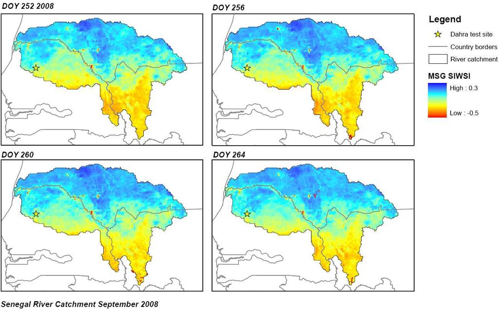
20 - Spatio-temporal Evaluation of SIWSI (2 pixels, 32 km 2 ) using NOAA RFE rainfall as surface water status indicator 2
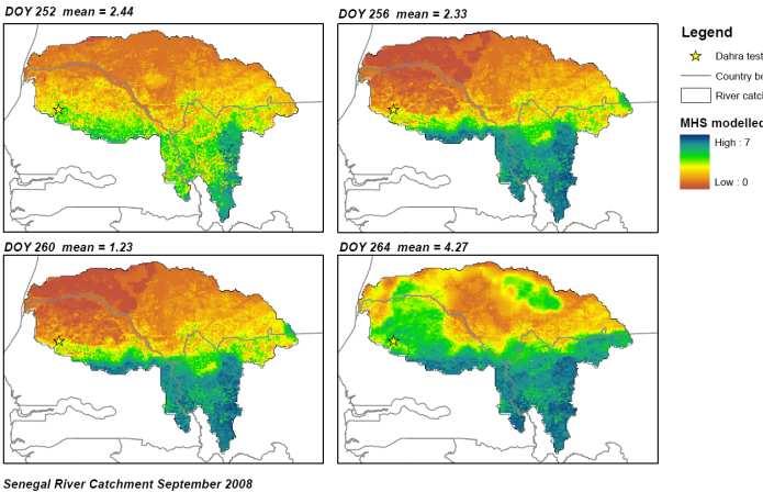
21 - Spatio-temporal evaluation of MSG SIWSI using a hydrological model (Mike-She distributed model) Is the model able to simulate water status at the Dahra test site? Are model inputs (RFE rainfall) reliable? Soil moisture (Vol %) EvapoTranspiration (mm/day) MSH model soil moist 25 cm in situ soil moist 3 cm MSH ETa
 Preliminary data analysis")
22 - Spatio-temporal evaluation of MSG SIWSI using a hydrological model (Mike-She distributed model) Preliminary data analysis 22

23 23

24 SIWSI NDVI ETa 24
25 Conclusions and perspectives - SWIR sensitivity to Canopy water content (semi-arid grass land) - MSG sensitivity on a daily scale - Biomass dependancy - SWIR based indices complementary to VIS/NIR approaches - SWIR based indices more robust to atm correction than VIS/NIR 9 Rainfall In situ MODIS NDVI Soil moisture 1 cm MODIS NDVI Rainfall (mm) adn Soil moisture (vol%)
UCS#4: Soil moisture assessment over Africa
 UCS#4: Soil moisture assessment over Africa S. Horion, H. Nieto*, T. Tagesson, R. Fensholt * Institute for Sustainable Agriculture CSIC, Córdoba, Spain Rationale and objectives Accurate estimates of soil
CROP STATE MONITORING USING SATELLITE REMOTE SENSING IN ROMANIA
 CROP STATE MONITORING USING SATELLITE REMOTE SENSING IN ROMANIA Dr. Gheorghe Stancalie National Meteorological Administration Bucharest, Romania Content Introduction Earth Observation (EO) data Drought
Vegetation monitoring in the framework of EUMETSAT Land Surface Analysis SAF (land-saf/lsa-saf):
:") Satellite products for drought monitoring and agro-meteorological applications. Budapest 24-28 April 2017 Alirio Arboleda. Vegetation monitoring in the framework of EUMETSAT Land Surface Analysis SAF (land-saf/lsa-saf):
Satellite products for drought monitoring and agro-meteorological applications. Budapest 24-28 April 2017 Alirio Arboleda. Vegetation monitoring in the framework of EUMETSAT Land Surface Analysis SAF (land-saf/lsa-saf):
Real-time Live Fuel Moisture Retrieval with MODIS Measurements
 Real-time Live Fuel Moisture Retrieval with MODIS Measurements Xianjun Hao, John J. Qu 1 {xhao1, jqu}@gmu.edu School of Computational Science, George Mason University 4400 University Drive, Fairfax, VA
Hydrological Applications of LST Derived from AVHRR
 Hydrological Applications of LST Derived from AVHRR By Balaji Narasimhan Research Assistant Department of Agricultural Engineering Texas A&M University Outline Introduction All about LST Model Development
Land Surface Analysis SAF (LSA SAF)
") Ref. Ares(2014)73020-15/01/2014 Land Surface Analysis SAF (LSA SAF) Pedro Viterbo, Lisboa, Portugal Acknowledgments: Isabel Trigo & the LSA SAF consortium 12-13 December 2011 Lisbon Layout Overview of
Ref. Ares(2014)73020-15/01/2014 Land Surface Analysis SAF (LSA SAF) Pedro Viterbo, Lisboa, Portugal Acknowledgments: Isabel Trigo & the LSA SAF consortium 12-13 December 2011 Lisbon Layout Overview of
Assessing the use of LSA SAF VEGA data for environmental monitoring in Africa: Fractional cover and natural vegetation condition assessment
 Toulouse 16 November 21 LSA SAF 4 th user workshop 1 Assessing the use of LSA SAF VEGA data for environmental monitoring in Africa: Fractional cover and natural vegetation condition assessment J.-F. Pekel,
Remotely-Sensed Carbon and Water Variations in Natural and Converted Ecosystems with Time Series MODIS Data
 Remotely-Sensed Carbon and Water Variations in Natural and Converted Ecosystems with Time Series MODIS Data Alfredo Ramon Huete 1 Piyachat Ratana 1 Yosio Edemir Shimabukuro 2 1 University of Arizona Dept.
Supplementary Material. A - Population density
 Gond, V. et al. Vegetation structure and greenness in Central Africa from MODIS multitemporal data. 2013. Phil Trans Roy Soc B 368 doi: 10.1098/rstb.2012.0309 Supplementary Material A - Population density
Remote Sensing of Water Resources
 Remote Sensing of Water Resources National Disaster Management Institute Yoomi Hur Climate Change Hydrologic Cycle Hydrologic Indices Soil Moisture Evaportranspiration Drought Conclusions 3 The water cycle
Remote Sensing of Land & Vegetation. C S Murthy
 Remote Sensing of Land & Vegetation C S Murthy Remote Sensing current status New era of RS in 21 st Century Increased utilisation of data Quantitative algorithms/improved retrieval methods Better calibrations
Evaluation of Indices for an Agricultural Drought Monitoring System in Arid and Semi-Arid Regions
 Evaluation of Indices for an Agricultural Drought Monitoring System in Arid and Semi-Arid Regions Alireza Shahabfar, Josef Eitzinger Institute of Meteorology, University of Natural Resources and Life Sciences
Hyperion. R=f(x,t,, ) 1. (t) van der Meer and Jong
 1. (t) van der Meer and Jong") 89 00 89 * 89 8 0 0 7 R=f(x,t,,) t x r TM MSS (x) (R) 0000 θ ( (t) van der Meer and Jong. 00 mobasheri@kntu.ac.iry * 89 90 (Ger Iris) Landsat TM Hunt 980 Hunt OH NH CN 980 Lignin IRIS van der Meer and
89 00 89 * 89 8 0 0 7 R=f(x,t,,) t x r TM MSS (x) (R) 0000 θ ( (t) van der Meer and Jong. 00 mobasheri@kntu.ac.iry * 89 90 (Ger Iris) Landsat TM Hunt 980 Hunt OH NH CN 980 Lignin IRIS van der Meer and
Integration of forest inventories with remotely sensed data for biomass mapping: First results for tropical Africa
 Integration of forest inventories with remotely sensed data for biomass mapping: First results for tropical Africa Alessandro Baccini Nadine Laporte Scott J. Goetz Mindy Sun Wayne Walker Jared Stabach
FRP-derived fuel consumption and vegetation productivity
 20 th -23 rd November GWIS and GOFC Fire IT meeting FRP-derived fuel consumption and vegetation productivity Gareth Roberts (University of Southampton) G.J.Roberts@soton.ac.uk LSA-SAF SEVIRI FRP-PIXEL
Assessing the hydrological impacts of climate change at the local scale: Dynamical coupling of a regional climate model to a hydrological model
 Assessing the hydrological impacts of climate change at the local scale: Dynamical coupling of a regional climate model to a hydrological model Martin Drews 1, Søren H. Rasmussen 1, Jens Hesselbjerg Christensen
The EUMETSAT Satellite Application Facility on Land Surface Analysis (LSA SAF) Continuous Development 2 Phase
 Continuous Development 2 Phase") The EUMETSAT Satellite Application Facility on Land Surface Analysis (LSA SAF) Continuous Development 2 Phase Jean-Louis Roujean and many co-authors METEO FRANCE / Toulouse jean-louis.roujean@meteo.fr
The EUMETSAT Satellite Application Facility on Land Surface Analysis (LSA SAF) Continuous Development 2 Phase Jean-Louis Roujean and many co-authors METEO FRANCE / Toulouse jean-louis.roujean@meteo.fr
Forest change detection in boreal regions using
 Forest change detection in boreal regions using MODIS data time series Peter Potapov, Matthew C. Hansen Geographic Information Science Center of Excellence, South Dakota State University Data from the
AGOG 485/585 APLN 533 Spring 2019
 AGOG 485/585 APLN 533 Spring 2019 Outline Vegetation analysis and related MODIS products Phenology and productivity Fire monitoring using MODIS and VIIRS data Readings: Textbook Chapter 17 FAQ on Vegetation
Investigating temporal relationships between rainfall, soil moisture and MODIS-derived NDVI and EVI for six sites in Africa
 Investigating temporal relationships between rainfall, soil moisture and MODIS-derived NDVI and EVI for six sites in Africa Jamali, Sadegh; Seaquist, Jonathan; Ardö, Jonas; Eklundh, Lars 2011 Link to publication
Land Surface Monitoring from the Moon
 Land Surface Monitoring from the Moon Jack Mustard, Brown University Workshop on Science Associated with Lunar Exploration Architecture Unique Perspective of Lunar Observation Platform Low Earth Orbit:
The vegetation monitoring in LSA SAF: overview and potential applications
 The vegetation monitoring in LSA SAF: overview and potential applications F. J. García-Haro, F. Camacho, B. Martínez, M.A. Gilabert, A. Moreno, J. Meliá 5th LSA SAF User Workshop 17-19 June 2013, Karlsruhe
The Science Behind Measuring Depletions
 The Science Behind Measuring Depletions 1 The Science Behind Measuring Depletions Salim Bawazir, New Mexico State University Salim Bawazir is Associate Professor in the Civil Engineering (CE) Department
VEGETATION AND SOIL MOISTURE ASSESSMENTS BASED ON MODIS DATA TO SUPPORT REGIONAL DROUGHT MONITORING
 University of Szeged Faculty of Science and Informatics Department of Physical Geography and Geoinformatics http://www.geo.u-szeged.hu kovacsf@geo.u-szeged.hu Satellite products for drought monitoring
Remote Sensing of Soil Moisture. Lecture 20 Nov. 7, 2005
 Remote Sensing of Soil Moisture Lecture 20 Nov. 7, 2005 What is soil moisture? Is defined as the ratio of liquid water content to the soil in percentage of volume or weight, is an inheritage and memory
VEGETATION AND SOIL MOISTURE ASSESSMENTS BASED ON MODIS DATA TO SUPPORT REGIONAL DROUGHT MONITORING
 University of Szeged Faculty of Science and Informatics Department of Physical Geography and Geoinformatics http://www.geo.u-szeged.hu kovacsf@geo.u-szeged.hu Satellite products for drought monitoring
The Spatial Analysis between SWAT Simulated Soil Moisture, and MODIS LST and NDVI Products
 Konkuk University, Seoul, South Korea The Spatial Analysis between SWAT Simulated Soil Moisture, and MODIS LST and NDVI Products Geun Ae PARK Post-doctoral Researcher, Dept. of Civil and Environmental
Crop Growth Remote Sensing Monitoring and its Application
 Sensors & Transducers 2014 by IFSA Publishing, S. L. http://www.sensorsportal.com Crop Growth Remote Sensing Monitoring and its Application Delan Xiong International School of Education, Xuchang University,
Chapter 4. Methodology and Modeling for Carbon Sequestration Pattern in Cashew Plantation
 Chapter 4 Methodology and Modeling for Carbon Sequestration Pattern in Cashew Plantation In this chapter, a new approach for carbon sequestration pattern of broad leaf vegetation is proposed using modified
Analysis of root-zone soil moisture control on evapotranspiration in two agriculture fields in Australia
 20th International Congress on Modelling and Simulation, Adelaide,, 1 6 December 2013 www.mssanz.org.au/modsim2013 Analysis of root-zone soil moisture control on evapotranspiration in two agriculture fields
Integrated Early-Warning Monitoring and Forecasting: Data Products
 Integrated Early-Warning Monitoring and Forecasting: Data Products John J. Qu, Xianjun Hao & Lingli Wang jqu@gmu.edu Environmental Science & Technology Center (ESTC) College of Science George Mason University
Land surface albedo and downwelling shortwave radiation from MSG: Retrieval, validation and impact assessment in NWP and LSM models
 Land surface albedo and downwelling shortwave radiation from MSG: Retrieval, validation and impact assessment in NWP and LSM models Jean-Louis ROUJEAN, Dominique CARRER, Xavier CEAMANOS, Olivier HAUTECOEUR,
Overview of Land Surface Parameters From Earth Observation
 Overview of Land Surface Parameters From Earth Observation Prof. Dr. Christiane Schmullius Friedrich Schiller University Jena, Germany Department of Geoinformatics and Remote Sensing FSU Jena Institut
Combined Use of Vegetation and Water Indices from Remotely-Sensed AVIRIS and MODIS Data to Monitor Riparian and Semiarid Vegetation
 Combined Use of Vegetation and Water Indices from Remotely-Sensed AVIRIS and MODIS Data to Monitor Riparian and Semiarid Vegetation Item Type text; Electronic Dissertation Authors Kim, Ho J Publisher The
Operational products for crop monitoring. Hervé Kerdiles, JRC MARS
 Operational products for crop monitoring Hervé Kerdiles, JRC MARS Outline Meteo products Rainfall, temperature, global radiation, ETa, snow depth Biomass indicators & crop yield prediction NDVI & other
Figure 1 Examples of recent environmental disasters in the Asia-Pacific region
 1. What is APEIS-IEM? 1.1 Objectives Environmental Conditions are deteriorating in the Asia-Pacific region, home to about 60 percent of the world s population and currently experiencing rapid population
Key Issues for EO of Land Surface Processes
 Key Issues for EO of Land Surface Processes Bernard Pinty EC-JRC Institute for Environment and Sustainability, Ispra, Italy Seconded to the Earth Observation Directorate, ESA-ESRIN, Frascati, Italy JRC
Estimating Soil Carbon Sequestration Potential: Regional Differences and Remote Sensing
 Estimating Soil Carbon Sequestration Potential: Regional Differences and Remote Sensing Tris West Environmental Sciences Division Technical Working Group on Agricultural Greenhouse Gases (T-AGG): Experts
Quantifying CO 2 fluxes of boreal forests in Northern Eurasia
 Quantifying CO 2 fluxes of boreal forests in Northern Eurasia Integrated analyses of in-situ eddy flux tower, remote sensing and biogeochemical model Xiangming Xiao Institute for the Study of Earth, Oceans
Global Burnt Area Products
 Global Burnt Area Products Kevin Tansey Department of Geography, University of Leicester, UK kevin.tansey@le.ac.uk Structure Why burnt area estimation is important Challenges to global burnt area mapping
MULTI-ANGULAR SATELLITE REMOTE SENSING AND FOREST INVENTORY DATA FOR CARBON STOCK AND SINK CAPACITY IN THE EASTERN UNITED STATES FOREST ECOSYSTEMS
 MULTI-ANGULAR SATELLITE REMOTE SENSING AND FOREST INVENTORY DATA FOR CARBON STOCK AND SINK CAPACITY IN THE EASTERN UNITED STATES FOREST ECOSYSTEMS X. Liu, M. Kafatos, R. B. Gomez, H. Wolf Center for Earth
Separation Of Soil Evaporation And Vegetation Transpiration By MODIS Data For Central And Northern China
 City University of New York (CUNY) CUNY Academic Works International Conference on Hydroinformatics 8-1-2014 Separation Of Soil Evaporation And Vegetation Transpiration By MODIS Data For Central And Northern
MODIS Remote Sensing. Dr Helen Cleugh CSIRO Marine and Atmospheric Research June 14, 2011
 Regional Land Surface Evaporation using MODIS Remote Sensing Dr Helen Cleugh CSIRO Marine and Atmospheric Research June 14, 2011 Acknowledgements e to CSIRO Colleagues Ray Leuning and Yongqiang g Zhang
LAND AND WATER - EARTH OBSERVATION INFORMATICS FSP
 Earth Observation for Water Resources Management Arnold Dekker,Juan P Guerschman, Randall Donohue, Tom Van Niel, Luigi Renzullo,, Tim Malthus, Tim McVicar and Albert Van Dijk LAND AND WATER - EARTH OBSERVATION
Quality Indicators for Societal Benefit QI4SB Irwin Alber (IEEE/ICEO)
") Quality Indicators for Societal Benefit QI4SB Irwin Alber (IEEE/ICEO) Workshop on Facilitating Implementation of QA4EO CEOS/WGCV 01 October, 2009 Antalya, Turkey 1 Outline QA of GEOSS data products for
Quality Indicators for Societal Benefit QI4SB Irwin Alber (IEEE/ICEO) Workshop on Facilitating Implementation of QA4EO CEOS/WGCV 01 October, 2009 Antalya, Turkey 1 Outline QA of GEOSS data products for
Research and Applications using Realtime Direct Broadcast Imagery, Weather Radar, and LiDAR in Disaster Response and Preparedness
 Research and Applications using Realtime Direct Broadcast Imagery, Weather Radar, and LiDAR in Disaster Response and Preparedness Richard P. Watson, Ph.D. University of New Mexico Earth Data Analysis Center
Water Availability Applications of SEBS in drought monitoring and estimation of large scale evapotranspiration
 Water Availability Applications of SEBS in drought monitoring and estimation of large scale evapotranspiration Z. (Bob) Su International Institute for Geo-Information Science and Earth Observation (ITC),
User Awareness & Training: LAND. Tallinn, Estonia 9 th / 10 th April 2014 GAF AG
 User Awareness & Training: LAND Tallinn, Estonia 9 th / 10 th April 2014 GAF AG Day 2 - Contents LAND (1) General Introduction to EO and the COPERNICUS Sentinel Programme Overview of COPERNICUS/GMES LAND
Issues include coverage gaps, delays, measurement continuity and consistency, data format and QC, political restrictions
 Satellite-based Estimates of Groundwater Depletion, Ph.D. Chief, Hydrological Sciences Laboratory NASA Goddard Space Flight Center Greenbelt, MD Groundwater Monitoring Inadequacy of Surface Observations
Mapping Water Use and Drought with Satellite Remote Sensing
 Xiwu Zhan NOAA-NESDIS-STAR Jason Otkin University of Wisconsin Mapping Water Use and Drought with Satellite Remote Sensing Christopher Hain NASA-MSFC Li Fang, Mitch Schull Earth System Science Interdisciplinary
Introduction to a MODIS Global Terrestrial Evapotranspiration Algorithm Qiaozhen Mu Maosheng Zhao Steven W. Running
 Introduction to a MODIS Global Terrestrial Evapotranspiration Algorithm Qiaozhen Mu Maosheng Zhao Steven W. Running Numerical Terradynamic Simulation Group, Dept. of Ecosystem and Conservation Sciences,
Dynamic Regional Carbon Budget Based on Multi-Scale Data-Model Fusion
 Dynamic Regional Carbon Budget Based on Multi-Scale Data-Model Fusion Mingkui Cao, Jiyuan Liu, Guirui Yu Institute Of Geographic Science and Natural Resource Research Chinese Academy of Sciences Toward
Assessing Land Degradation/Recovery in the African Sahel from Long-Term Earth Observation Based Primary Productivity and Precipitation Relationships
 Remote Sens. 2013, 5, 664-686; doi:10.3390/rs5020664 Article OPEN ACCESS Remote Sensing ISSN 2072-4292 www.mdpi.com/journal/remotesensing Assessing Land Degradation/Recovery in the African Sahel from Long-Term
Using MODIS Medium-Resolution Remote Sensing Data to Monitor Hydroclimatic Variability
 Using MODIS Medium-Resolution Remote Sensing Data to Monitor Hydroclimatic Variability Past and Future Hydroclimatic Variability: Applications to water Resources Management in the Prairie Provinces, Canmore,
WIDE-SCALE MODELLING OF WATER AND WATER AVAILABILITY WITH EARTH OBSERVATION/SATELLITE IMAGERY
 WIDE-SCALE MODELLING OF WATER AND WATER AVAILABILITY WITH EARTH OBSERVATION/SATELLITE IMAGERY Ferreira F 1, Goudriaan R 2, Gibson LA 3, Jarmain C 4, Kemp JN 6, Mashimbye E 5, Münch Z 6, Pauw T 6, Stephenson
DOE scientific successes as part of the International LAnd Model Benchmarking (ILAMB) Project
 Project") DOE scientific successes as part of the International LAnd Model Benchmarking (ILAMB) Project December 14, 2015 Office of Science Office of Biological and Environmental Research Outline 1. Introduction
DOE scientific successes as part of the International LAnd Model Benchmarking (ILAMB) Project December 14, 2015 Office of Science Office of Biological and Environmental Research Outline 1. Introduction
Crop Growth Monitor System with Coupling of AVHRR and VGT Data 1
 Crop Growth Monitor System with Coupling of AVHRR and VGT Data 1 Wu Bingfng and Liu Chenglin Remote Sensing for Agriculture and Environment Institute of Remote Sensing Application P.O. Box 9718, Beijing
Københavns Universitet
 university of copenhagen Københavns Universitet Assessing land degradation/recovery in the African Sahel from long-term earth observation based primary productivity and precipitation relationships Fensholt,
Remote Sensing and Image Processing: 9
 Remote Sensing and Image Processing: 9 Dr. Mathias (Mat) Disney UCL Geography Office: 301, 3rd Floor, Chandler House Tel: 7670 4290 (x24290) Email: mdisney@geog.ucl.ac.uk www.geog.ucl.ac.uk/~mdisney 1
th Conf on Hydrology, 85 th AMS Annual Meeting, 9-13 Jan, 2005, San Diego, CA., USA.
 4.12 19th Conf on Hydrology, 85 th AMS Annual Meeting, 9-13 Jan, 5, San Diego, CA., USA. IMPACT OF DEFORESTATION ON THE PROPOSED MESOAMERICAN BIOLOGICAL CORRIDOR IN CENTRAL AMERICA Ronald M Welch 1, Deepak
Synergy between polar-orbiting and geostationary sensors:
 Synergy between polar-orbiting and geostationary sensors: Remote sensing of the ocean at high spatial and high temporal resolution. Quinten Vanhellemont, Griet Neukermans, Kevin Ruddick Management Unit
ENVIRONMENTAL MONITORING IN MONGOLIA SUPPORTED WITH MODIS AND FY-2C SATELLITE DATA
 ENVIRONMENTAL MONITORING IN MONGOLIA SUPPORTED WITH MODIS AND FY-2C SATELLITE DATA M. Erdenetuya M. Erdenetuya (PhD), Component Coordinator of NGIC project, MNE Juulchinii Str 5, Room 100, Ulaanbaatar
Figure 1. Location of research sites in the Ameriflux network (from Ameriflux web site,
 CONTEXT - AMERIFLUX NETWORK Figure 1. Location of research sites in the Ameriflux network (from Ameriflux web site, http://public.ornl.gov/ameriflux/). AMERIFLUX OBJECTIVES: Quantify spatial and temporal
Mountain hydrology of the semi-arid western U.S.: Research needs, opportunities & challenges
 Mountain hydrology of the semi-arid western U.S.: Research needs, opportunities & challenges Roger Bales 1, Jeff Dozier 2, Noah Molotch 3, Tom Painter 3, Bob Rice 1 1 UC Merced. 2 UC Santa Barbara, 3 U
Estimating and evaluating GPP in the Sahel using MSG/SEVIRI and MODIS satellite data
 Student thesis series INES nr 352 Estimating and evaluating GPP in the Sahel using MSG/SEVIRI and MODIS satellite data Gustav Wallner 2015 Department of Physical Geography and Ecosystem Science Lund University
Hydrological links between cosmic-ray soil moisture retrievals and remotely sensed evapotranspiration across a semi-arid pasture site
 21st International Congress on Modelling and Simulation, Gold Coast, Australia, 29 Nov to 4 Dec 2015 www.mssanz.org.au/modsim2015 Hydrological links between cosmic-ray soil moisture retrievals and remotely
Map Asia Conference 2009
 Monitoring Regional Evapotranspiration Using SEBAL Approach and MODIS Time-Series Data in the Center of Rice Producing Regions in West Java Indonesia Dewi Kania Sari 1,2 Ishak H. Ismullah 1, Widyo Nugroho
Remote Measurements of Active Fire Behavior and Post-Fire Effects
 Remote Measurements of Active Fire Behavior and Post-Fire Effects Alistair Smith (and many many others ) Remote Sensing: A very Brief Overview ~ 5 million years B.C. : Humans Begin to Understand their
Spatial Mapping of Actual Evapotranspiration and Soil Moisture in the Murrumbidgee Catchment: Examples from National Airborne Field Experimentation
 Spatial Mapping of Actual Evapotranspiration and Soil Moisture in the Murrumbidgee Catchment: Examples from National Airborne Field Experimentation Mohsin Hafeez 1,2,3, Shahbaz Khan 1,2,3, Kaishan Song
West Africa: the 2017 Season
 West Africa: the 2017 Season Late season dryness affects Sahelian areas Bulletin # 5 October 2017 1 Contents Highlights 1. HIGHLIGHTS...2 2. THE SEASON AT A GLANCE...3 3. MAY TO JULY 2017...4 4. AUGUST
Vulnerability of Primary Production to Climate Extremes Lessons from the 2003 heatwave in Europe
 Vulnerability of Primary Production to Climate Extremes Lessons from the 2003 heatwave in Europe Ph. Ciais, M. Reichstein, N. Viovy A. Granier, J. Ogée, V. Allard, M. Aubinet, Chr. Bernhofer, A. Carrara,
Factors Affecting Gas Species Released in BB. Factors Affecting Gas Species Released in BB. Factors Affecting Gas Species Released in BB
 Factors Affecting Gas Species Trace from Biomass Burning. The Main Variables* The Amount and Type of gas species released from fire are conditioned by: Chemical and Physical features of the Ecosystem *(Alicia
Remote sensing as a tool to detect and quantify vegetation properties in tropical forest-savanna transitions Edward Mitchard (University of Edinburgh)
") Remote sensing as a tool to detect and quantify vegetation properties in tropical forest-savanna transitions Edward Mitchard (University of Edinburgh) Presentation to Geography EUBAP 10 th Oct 2008 Supervisor:
Remote sensing as a tool to detect and quantify vegetation properties in tropical forest-savanna transitions Edward Mitchard (University of Edinburgh) Presentation to Geography EUBAP 10 th Oct 2008 Supervisor:
MODIS ,,, 2005, %, Vol. 30,No. 7 July,2008 RESOURCES SCIENCE : (2008) : ; :
 : ; :") 2008 7 RESOURCES SCIENCE Vol. 30,No. 7 July,2008 :1007-7588(2008) 07-1076 - 08 MODIS 1,2, 1,2, 3,4 (1., 100101 ; 2., 100049 ; 3., 100875 ; 4., 100875) :,,,, MOD09Q1 1 2,MOD09A1 6 MOD11A2,, NDVI NDSI LST
2008 7 RESOURCES SCIENCE Vol. 30,No. 7 July,2008 :1007-7588(2008) 07-1076 - 08 MODIS 1,2, 1,2, 3,4 (1., 100101 ; 2., 100049 ; 3., 100875 ; 4., 100875) :,,,, MOD09Q1 1 2,MOD09A1 6 MOD11A2,, NDVI NDSI LST
Role and importance of Satellite data in the implementation of the COMIFAC Convergence Plan
 Plenary Meeting of the Congo Basin Forest Partnership (CBFP) Palais des Congrès, Yaoundé. Cameroon 11-12 November, 2009 Role and importance of Satellite data in the implementation of the COMIFAC Convergence
Monitoring of evapotranspiration using microwave and optical remote sensing observations: rate limiting factors under different climate conditions
 International Workshop on Remote Sensing and Eco-hydrology in Arid Regions Monitoring of evapotranspiration using microwave and optical remote sensing observations: rate limiting factors under different
Title. From a global ecosystem model to national studies on biomass estimation & livestock insurance (WP3.2 Livestock systems)
") Title From a global ecosystem model to national studies on biomass estimation & livestock insurance (WP3.2 Livestock systems) Julien Minet 1, Abdoul Aziz Diouf 1,2, Issa Garba 1,3, Marie Lang 1,4,5, Bakary
Title From a global ecosystem model to national studies on biomass estimation & livestock insurance (WP3.2 Livestock systems) Julien Minet 1, Abdoul Aziz Diouf 1,2, Issa Garba 1,3, Marie Lang 1,4,5, Bakary
STUDY ON SOIL MOISTURE BY THERMAL INFRARED DATA
 THERMAL SCIENCE, Year 2013, Vol. 17, No. 5, pp. 1375-1381 1375 STUDY ON SOIL MOISTURE BY THERMAL INFRARED DATA by Jun HE a, Xiao-Hua YANG a*, Shi-Feng HUANG b, Chong-Li DI a, and Ying MEI a a School of
Recent increased frequency of drought events in Poyang Lake Basin, China: climate change or anthropogenic effects?
 Hydro-climatology: Variability and Change (Proceedings of symposium J-H02 held during IUGG2011 in Melbourne, Australia, July 2011) (IAHS Publ. 344, 2011). 99 Recent increased frequency of drought events
SCIE 4104E - Environmental Systems Science. Tarendra Lakhankar NOAA-CREST Center, The City University of New York
 SCIE 4104E - Environmental Systems Science Tarendra Lakhankar NOAA-CREST Center, The City University of New York About Class This course focuses on Earth as a system and explores the interdependent relationships
Remotely-Sensed Fire Danger Rating System to Support Forest/Land Fire Management in Indonesia
 Remotely-Sensed Fire Danger Rating System to Support Forest/Land Fire Management in Indonesia Orbita Roswintiarti Indonesian National Institute of Aeronautics and Space (LAPAN) SE Asia Regional Research
Applications of hyperspectral data collected during the AACES field campaign
 Applications of hyperspectral data collected during the AACES field campaign Marta Yebra & Juan Pablo Guerschman with contributions from Guy Byrne (CLW), Mariano Oyarzabal (IFEVA) and Sara Jurdao (UAH)
Temporal Responses of Vegetation to Climatic Factors in Kazakhstan and Middle Asia
 Temporal Responses of Vegetation to Climatic Factors in Kazakhstan and Middle Asia Pavel P. Propastin and Martin Kappas, Germany Nadiya R. Muratova, Kazakhstan Key words: NDVI; Climate variability, Vegetation
Remote Sensing Uses in Agriculture at NASS
 Remote Sensing Uses in Agriculture at NASS United States Department of Agriculture (USDA) National Agriculture Statistics Service (NASS) Research and Development Division Geospatial Information Branch
Remote sensing: A suitable technology for crop insurance?
 Remote sensing: A suitable technology for crop insurance? Geospatial World Forum 2014 May 9, 2014, Geneva, Switzerland Agenda 1. Challenges using RS technology in crop insurance 2. Initial situation Dominance
Drought Monitoring and Early Warning in West Africa. At the AGRHYMET Regional Center. By Seydou B. TRAORE,
 Drought Monitoring and Early Warning in West Africa At the AGRHYMET Regional Center By Seydou B. TRAORE, agrometeorologist 1 Outline Introduction Background information about AGRHYMET The Early Warning
1 Context and objective. 2 Study sites and measurements
 Applications of VEGETATION data to resource management in arid and semi-arid rangelands B. Mougenot 1, A. Bégué 2, G. Chehbouni 3, R. Escadafal 1, P. Heilman 4, J. Qi 5, A. Royer 6, C. Watts 7 1 IRD/CESBIO,
Evaluating Vegetation Evapotranspiration (VegET) Modeling Results in South Dakota
 Modeling Results in South Dakota") Evaluating Vegetation Evapotranspiration (VegET) Modeling Results in South Dakota Gabriel Senay 1 and Geoffrey Henebry 2 1 SAIC, contractor to the U.S. Geological Survey (USGS) Center for Earth Resources
Evaluating Vegetation Evapotranspiration (VegET) Modeling Results in South Dakota Gabriel Senay 1 and Geoffrey Henebry 2 1 SAIC, contractor to the U.S. Geological Survey (USGS) Center for Earth Resources
Predicting energy and water cycle response to changing climate and land cover conditions in the cultivated Sahel
 Predicting energy and water cycle response to changing climate and land cover conditions in the cultivated Sahel C. VELLUET, J. DEMARTY, B. CAPPELAERE, I. BRAUD, N. BOULAIN, G. CHARVET, J.-P. CHAZARIN,
POSSIBILITY OF GCOM-C1 / SGLI FOR CLIMATE CHANGE IMPACTS ANALYZING
 POSSIBILITY OF GCOM-C1 / SGLI FOR CLIMATE CHANGE IMPACTS ANALYZING Y. Honda* a, M. Moriyama b, M. Hori c, M. Murakami c, A. Ono c, K. Kajiwara a a Center for Environmental Remote Sensing (CEReS), Chiba
Crop Modelling & Yield Forecasting
 Crop Modelling & Yield Forecasting AGRICAB FINAL MEETING 23-24/03/2015 Hendrik Boogaard Alterra, WUR hendrik.boogaard@wur.nl WP31 Crop Production Systems Agricultural statistics Agro-meteorological modeling
Effects of Land Use On Climate and Water Resources: Application of a Land Surface Model for Land Use Management
 Effects of Land Use On Climate and Water Resources: Application of a Land Surface Model for Land Use Management Gordon Bonan, PI National Center for Atmospheric Research Boulder, Colorado Personnel Supported:
Recommendations for a Global Fire Assimilation System (GFAS) in GMES
 in GMES") Recommendations for a Global Fire Assimilation System (GFAS) in GMES J.W. Kaiser & M.G. Schultz contributions from: R. Engelen, J.-M. Gregoire, A. Hollingsworth, S. Serrar, M. Sofiev, C. Textor GOLD/GOFC
Recommendations for a Global Fire Assimilation System (GFAS) in GMES J.W. Kaiser & M.G. Schultz contributions from: R. Engelen, J.-M. Gregoire, A. Hollingsworth, S. Serrar, M. Sofiev, C. Textor GOLD/GOFC
Mapping the Boreal zone forest cover and forest cover loss 2000 to 2005
 Matthew Hansen a, Peter Potapov a, Steve Stehman b, Kyle Pittman a, Thomas Loveland c, Mark Carroll d, Charlene DiMiceli d Mapping the Boreal zone forest cover and forest cover loss 2000 to 2005 a - South
Improving burning efficiency estimates through satellite assessment of fuel moisture content
 JOURNAL OF GEOPHYSICAL RESEARCH, VOL. 109,, doi:10.1029/2003jd003467, 2004 Improving burning efficiency estimates through satellite assessment of fuel moisture content Emilio Chuvieco, David Cocero, Inmaculada
The role of Remote Sensing in Irrigation Monitoring and Management. Mutlu Ozdogan
 The role of Remote Sensing in Irrigation Monitoring and Management Mutlu Ozdogan Outline Why do we care about irrigation? Remote sensing for irrigated agriculture What are the needs of irrigators? Future
EARTH OBSERVATION FOR MONITORING WATER RESOURCES AND IRRIGATION DEMAND
 EARTH OBSERVATION FOR MONITORING WATER RESOURCES AND IRRIGATION DEMAND Guido D Urso University of Naples Federico II & ARIESPACE srl Academic Spin-off Key-words: Sustainable use of natural resources Planning
IPC. Guidelines for using Remote Sensing Derived Information in support of the IPC analysis 1. The Integrated Food Security Phase Classification
 IPC The Integrated Food Security Phase Classification Guidelines for using Remote Sensing Derived Information in support of the IPC Analysis Rembold F.*, Korpi K.*, Rojas O.* 1 *Joint Research Centre of
Effects of Vegetation Dynamics on the relation between ET and soil moisture in the North American Monsoon region
 Effects of Vegetation Dynamics on the relation between ET and soil moisture in the North American Monsoon region Enrique R. Vivoni 1, Hernan A. Moreno 1, Giuseppe Mascaro 1, Julio C. Rodriguez 2, Christopher
Estimating Canopy Water Content from Airborne and Satellite Platforms
 Estimating Canopy Water Content from Airborne and Satellite Platforms Susan L. Ustin, David Riaño and Marco Trombetti University of California Davis International Workshop on Advances in Operation Weather