patersongroup Phase II Environmental Site Assessment Commercial Properties 1445 and 1451 Wellington Street West Ottawa, Ontario Prepared For
|
|
|
- Shanon Cannon
- 5 years ago
- Views:
Transcription
1 Geotechnical Engineering patersongroup Environmental Engineering Hydrogeology Geological Engineering Materials Testing Building Science Phase II Environmental Site Assessment Commercial Properties 1445 and 1451 Wellington Street West Archaeological Services Prepared For Mizrahi Developments Paterson Group Inc. Consulting Engineers 154 Colonnade Road South Ottawa (Nepean), Ontario Canada K2E 7J5 Tel: (613) Fax: (613) June 11, 2013 Report: PE3003-2
2 Phase II Environmental Site Assessment Ottawa Kingston North Bay Commercial Properties, 1445 and 1451 Wellington Street West, Table of Contents EXECUTIVE SUMMARY... iii 2.0 INTRODUCTION Site Description Property Ownership Current and Proposed Future Uses Applicable Site Condition Standard BACKGROUND INFORMATION Physical Setting Past Investigations SCOPE OF INVESTIGATION Overview of Site Investigation Media Investigated Phase I Conceptual Site Model Deviations from Sampling and Analysis Plan Impediments INVESTIGATION METHOD Subsurface Investigation Soil Sampling Field Screening Measurements Groundwater Monitoring Well Installation Field Measurement of Water Quality Parameters Groundwater Sampling Analytical Testing Residue Management Elevation Surveying Quality Assurance and Quality Control Measures REVIEW AND EVALUATION Geology Groundwater Elevations, Flow Direction, and Hydraulic Gradient Fine-Medium Soil Texture Soil: Field Screening Soil Quality Groundwater Quality Quality Assurance and Quality Control Results Phase II Conceptual Site Model CONCLUSIONS STATEMENT OF LIMITATIONS Report: PE June 11, 2013 Page i
3 Phase II Environmental Site Assessment Ottawa Kingston North Bay Commercial Properties, 1445 and 1451 Wellington Street West, List of Figures Figure 1 - Key Plan Drawing PE Test Hole Location Plan Drawing PE Groundwater Contour Plan Drawing PE Cross-Section A-A List of Appendices Appendix 1 Soil Profile and Test Data Sheets Laboratory Certificates of Analysis Report: PE June 11, 2013 Page ii
4 Phase II Environmental Site Assessment Ottawa Kingston North Bay Commercial Properties, 1445 and 1451 Wellington Street West, EXECUTIVE SUMMARY Assessment A Phase II ESA was conducted for the properties at 1445 and 1451 Wellington Street West,. The purpose of the Phase II ESA was to address areas of potential environmental concern identified during the Phase I ESA, in particular the subject site s past use as an automotive service garage and retail fuel outlet, as well as the presence of a retail fuel outlet to the south and a former retail fuel outlet to the west. The Phase II ESA incorporates the findings of two (2) previous subsurface investigations at the site, completed in 2006 and 2009 respectively. The 2013 subsurface investigation at the subject site consisted of the drilling of four (4) boreholes and the installation of two (2) monitoring wells, for a total of three (3) bedrock and two (2) overburden monitoring wells at the subject site. Soil samples were obtained from the boreholes and screened using visual observations and organic vapour measurements. A total of 10 soil samples were submitted for laboratory analysis of BTEX and PHCs. Six (6) of the soil samples exceeded MOE Table 3 standards for BTEX and PHC parameters, with the area of soil contamination generally present in the south and central portions of 1451 Wellington Street West. Groundwater samples were obtained from the monitoring wells at BH2, BH6, BH12, BH1-13, and BH3-13 and analyzed for BTEX and PHCs. All groundwater sample locations exceeded MOE Table 3 standards for BTEX and PHC parameters with the exception of BH1-13, indicating that groundwater contamination is present over much of the site. Recommendations Based on the above results, soil and groundwater exist at the subject property with PHC concentrations which exceed the applicable MOE Table 3 soil standards. It is our understanding that the subject site is to be redeveloped as residential, and that the existing buildings are to be removed and demolished. It is our recommendation that an environmental site remediation program, involving the removal of all contaminated soil and groundwater from the subject site, be completed concurrently with site redevelopment. Report: PE June 11, 2013 Page iii
5 Phase II Environmental Site Assessment Ottawa Kingston North Bay Commercial Properties, 1445 and 1451 Wellington Street West, 2.0 INTRODUCTION At the request of Mizrahi Developments, Paterson Group (Paterson) conducted a Phase II Environmental Site Assessment of the properties addressed as 1445 and 1451 Wellington Street West, in the City of. The purpose of this Phase II ESA was to address concerns identified in the Phase I ESA, including the historical presence of an automotive service garage and retail fuel outlet at 1451 Wellington Street and the presence of a retail fuel outlet at 369 Island Park Drive. 2.1 Site Description Address: Legal Description: 1445 and 1451 Wellington Street West, Ottawa, Ontario. Lots 1, 2, 4 and the west half of Lot 4 north of Richmond Road, Registered Plan 145, in the City of. Property Identification Number: ; Location: The subject site is located at the northeast corner of the intersection of Wellington Street West and Island Park Drive, in the City of. The subject site is shown on Figure 1 - Key Plan following the body of this report. Latitude and Longitude: 45 23' 51" N, 75 44' 37" W. Configuration: Site Area: Approximately rectangular hectares (approximate). Report: PE June 11, 2013 Page 1
6 Phase II Environmental Site Assessment Ottawa Kingston North Bay Commercial Properties, 1445 and 1451 Wellington Street West, 2.2 Property Ownership The subject property addressed 1445 Wellington Street West is currently owned by Alfredo Giannuzzi, Mario Giannuzzi and Eugenio Milito. The subject property addressed 1451 Wellington Street West is currently owned by Mizrahi Development Group (1451 Wellington) Inc. Paterson was retained to complete this Phase II ESA by Dr. Mahdi Tajbakhsh of Mizrahi Developments. The offices of Mizrahi Developments are located at 126 Hazelton Avenue, Toronto, Ontario. Dr. Tajbakhsh can be reached by telephone at (416) Current and Proposed Future Uses The property addressed 1445 Wellington Street West is occupied by a two-storey residential building with basement converted to commercial use (restaurant). Based on the chain of title and the observed age of the subject building, the site appears to have been developed with the current building in approximately The property addressed 1451 Wellington Street West is occupied by a single storey commercial building. The eastern (original) portion of the building consists of two (2) garage/car washports and detailing bays as well as storage areas and a furnace room. The western portion of the building consists of office space. The eastern (original) portion of the building appears to have been developed in the 1930s, with an addition to the west constructed during the 1970s. It is our understanding that the subject site will be redeveloped as a residential property. 2.4 Applicable Site Condition Standard The site condition standards for the property were obtained from Table 3 of the document entitled Soil, Ground Water and Sediment Standards for Use Under Part XV.1 of the Environmental Protection Act, prepared by the Ontario Ministry of the Environment (MOE), April The MOE Table 3 Standards are based on the following considerations: Coarse-grained soil conditions Non-potable groundwater conditions Residential land use Report: PE June 11, 2013 Page 2
7 Phase II Environmental Site Assessment Ottawa Kingston North Bay Commercial Properties, 1445 and 1451 Wellington Street West, Analytical results were also compared to the MOE Table 1 (background) standards for the purposes of classification of site soils for off-site disposal if required for construction/redevelopment purposes. Report: PE June 11, 2013 Page 3
8 Phase II Environmental Site Assessment Ottawa Kingston North Bay Commercial Properties, 1445 and 1451 Wellington Street West, 3.0 BACKGROUND INFORMATION 3.1 Physical Setting The subject site is currently occupied by two commercial buildings: ProShine Car Wash (1451 Wellington Street West), and Bella s Bistro (1445 Wellington Street West) and associated paved asphalt parking areas. Site topography slopes gently downward towards the north. Drainage consists primarily of sheet flow to catch basins in the parking lot at 1451 Wellington Street West and along Wellington Street West. No areas of stressed vegetation were noted on the subject site. No water wells or private sewage systems were observed on the subject property at the time of the site visit. No rail lines or loading areas were observed at the subject site. No unidentified substances were observed on-site. No water bodies are present on the subject site. The nearest significant water body is the Ottawa River, located approximately 1.0 km to the north of the site. No Areas of Natural or Scientific Interest (ANSIs) are present within 250 m of the subject site. 3.2 Past Investigations Paterson has completed a Phase I ESA for the subject site, provided under separate cover. Paterson has also completed two (2) subsurface investigations at the subject property in 2006 and This report incorporates the findings of the previous subsurface investigations with those of the current subsurface investigation, in order to meet the requirements of O.Reg. 153/04 as amended by O.Reg. 269/11. Report: PE June 11, 2013 Page 4
9 Phase II Environmental Site Assessment Ottawa Kingston North Bay Commercial Properties, 1445 and 1451 Wellington Street West, 4.0 SCOPE OF INVESTIGATION 4.1 Overview of Site Investigation The subsurface investigation conducted as a component of this Phase II ESA consisted of the drilling of four (4) boreholes at the property addressed 1445 Wellington Street West. Two (2) of these boreholes were cored into bedrock. Groundwater monitoring wells were installed in the two (2) boreholes that were cored into the bedrock. Boreholes were drilled through overburden soils to a maximum depth of 3.18 m below ground surface. Bedrock was cored to a maximum depth of 6.70 m below ground surface. An additional twelve (12) boreholes were drilled during two previous subsurface investigations by Paterson for the property addressed 1451 Wellington Street West, in 2006 and Boreholes were drilled through overburden soils to a maximum depth of 4.78 m below ground surface. Bedrock was cored in four (4) boreholes to a maximum depth of 8.18 m. Groundwater monitoring wells were installed in three (3) of the boreholes. A total of five (5) groundwater monitoring wells have been installed on the properties. 4.2 Media Investigated During the subsurface investigation, soil samples and groundwater samples were obtained and submitted for laboratory analysis. The rationale for sampling and analyzing these media is based on the Contaminants of Potential Concern identified in the Phase I ESA. Contaminants of concern for soil and groundwater are BTEX and PHCs. 4.3 Phase I Conceptual Site Model Geological and Hydrogeological Setting Based on information from the Geological Survey of Canada and previous subsurface investigations completed at the subject site, drift thickness in the area of the subject site is approximately 3 to 5 m. Overburden soils consist of fill over glacial till, and bedrock consists of middle Ordovician limestone and dolostone of the Gull River Formation. Report: PE June 11, 2013 Page 5
10 Phase II Environmental Site Assessment Ottawa Kingston North Bay Commercial Properties, 1445 and 1451 Wellington Street West, Contaminants of Potential Concern The following CPCs were identified with respect to the subject site: Petroleum Hydrocarbons Fractions 1 through 4 (PHCs F1-F4) this suite of parameters encompasses gasoline (Fraction 1), diesel and fuel oil (Fraction 2), and heavy oils (Fractions 3 and 4). PHCs F1-F4 were selected as CPCs for the Phase I property based on the subject site s past use as a retail fuel outlet and automotive service garage, and based on the presence of the retail fuel outlet at 369 Island Park Drive. Gasoline and diesel are commonly used motor vehicle fuels, and diesel-fraction hydrocarbons were commonly used as heating oil. Heavy oils may be present in the form of lubricants and transmission or hydraulic fluids. PHCs may be present in the soil matrix, sorbed to soil particles, as well as in free or dissolved phase in the groundwater system. PHCs are generally considered to be LNAPLs light non-aqueous phase liquids, indicating that when present in sufficient concentrations above the solubility limit, they will partition into a separate phase above the water table, due to their lower density. BTEX this suite of parameters includes Benzene, Toluene, Ethylbenzene, and Xylenes (BTEX), associated with gasoline. These parameters were selected as CPCs for the Phase I study area based on the subject site s past use as an automotive service garage and retail fuel outlet, and based on the presence of the retail fuel outlet at 369 Island Park Drive. BTEX may be present in the soil matrix as well as in the dissolved phase in the groundwater system. The mechanisms of contaminant transport within the site soils include physical transportation and leaching. Physical transportation includes any intentional or unintentional movement or distribution of soil by physical means. Contamination arising from localized spills or runoff from the washing area on-site may be physically transported by vehicle movement or site grading. Leaching may occur in areas where the ground surface consists of gravel or where asphalt quality is poor; precipitation infiltrating in these areas may transport surficial contaminants into lower strata. Leaching and physical transport as contaminant transport mechanisms are considered to be limited at the subject site due to the presence of asphaltic concrete pavement over much of the site. Report: PE June 11, 2013 Page 6
11 Phase II Environmental Site Assessment Ottawa Kingston North Bay Commercial Properties, 1445 and 1451 Wellington Street West, The mechanisms of contaminant transport within the groundwater system include advection, dispersion, and diffusion. Advection and dispersion will be the dominant mechanisms of contaminant transport in soils with higher hydraulic conductivities, such as sands, gravels, silts, and some glacial till soils, whereas diffusion will dominate in soils with lower hydraulic conductivity, such as clays. Existing Buildings and Structures The subject site is occupied by the following buildings: 1445 Wellington Street West - a two-storey residential dwelling converted to a commercial building (restaurant) - wood-frame structure faced with brick, constructed in the late 1890s or early 1900s 1451 Wellington Street West - a single-storey commercial building (Pro- Shine Car Wash, formerly Joe s Car Audio and an automotive service garage/retail fuel outlet) - original portion constructed in the late 1930s to early 1940s with an addition constructed in the 1970s. Water Bodies There are no water bodies on the subject site or within the Phase I study area. The closest water body is the Ottawa River, located approximately 1.0 km to the north of the site. Areas of Natural Significance No areas of natural significance were identified on the site or in the Phase I study area. Drinking Water Wells No drinking water wells are located at the subject site or within the Phase I study area. Neighbouring Land Use Neighbouring land use in the Phase I study area is commercial, and residential. Report: PE June 11, 2013 Page 7
12 Phase II Environmental Site Assessment Ottawa Kingston North Bay Commercial Properties, 1445 and 1451 Wellington Street West, Potentially Contaminating Activities and Areas of Potential Environmental Concern Potentially Contaminating Activities and Areas of Potential Environmental Concern identified include historical use of the subject site as a retail fuel outlet and automotive service garage, as well as the presence of a retail fuel outlet to the south at 369 Island Park Drive. Additional Potentially Contaminating Activities were identified within the Phase I study area but were not considered to represent Areas of Potential Environmental Concern. Assessment of Uncertainty and/or Absence of Information The information available for review as part of the preparation of the Phase I ESA is considered to be sufficient to conclude that there are areas of potential environmental concern on the subject site and neighbouring properties which have the potential to have impacted the subject site. The presence of potentially contaminating activities was confirmed by a variety of independent sources, including, in some cases, observations made during the Phase I site visit. As such, the conclusions of this report are not affected by uncertainty which may be present with respect to the individual sources. 4.4 Deviations from Sampling and Analysis Plan The Sampling and Analysis Plan for this project is included in Appendix 1 of this report. Field measurement of water quality parameters was not undertaken. No other deviations were noted. 4.5 Impediments No physical impediments or denial of access were encountered during the Phase II Environmental Site Assessment. Report: PE June 11, 2013 Page 8
13 Phase II Environmental Site Assessment Ottawa Kingston North Bay Commercial Properties, 1445 and 1451 Wellington Street West, 5.0 INVESTIGATION METHOD 5.1 Subsurface Investigation The subsurface investigation was conducted on May 13, 2013, and consisted of the drilling of four (4) boreholes on the subject site. The boreholes were placed to provide general coverage of 1445 Wellington Street West. The boreholes were advanced using a truck-mounted CME 55 power auger drill rig. The drilling contractor was George Downing Estate Drilling of Hawkesbury, Ontario. Drilling occurred under full-time supervision of Paterson personnel. Borehole locations are shown on Drawing No. PE Test Hole Location Plan, appended to this report. The findings of two previous subsurface investigations at 1451 Wellington Street West conducted in October 2006 and November 2009 are incorporated into this report. 5.2 Soil Sampling A total of 77 soil samples were obtained from the boreholes by means of split spoon sampling and the sampling of shallow soils directly from auger flights. Split spoon samples were taken at approximate 0.76 m intervals. The depths at which split spoon and auger flight samples were obtained from the boreholes are shown as and AU respectively on the Soil Profile and Test Data Sheets, appended to this report. Upon refusal of the augers, several boreholes were advanced into bedrock using a diamond coring system. Rock core samples were recovered, and are shown as RC on the Soil Profile and Test Data Sheets. Site soils consist of fill material underlain by an intermittent layer of glacial till over limestone bedrock. Practical refusal to augering was encountered at depths varying from 2.34 to 4.14 m below existing grade. Report: PE June 11, 2013 Page 9
14 Phase II Environmental Site Assessment Ottawa Kingston North Bay Commercial Properties, 1445 and 1451 Wellington Street West, 5.3 Field Screening Measurements All soil samples collected underwent a preliminary screening procedure, which included visual screening for colour and evidence of deleterious fill, as well as screening with a RKI Eagle combustible gas detector. The detection limit is 5 ppm, with a precision of +/- 5 ppm. The soil vapours were measured by inserting the analyzer probe into the nominal headspace above the soil sample. Samples were then agitated and the peak readings recorded. The combustible vapour readings ranged from 0 ppm to 100% of the lower explosive limit (LEL). Combustible vapour readings are noted on the Soil Profile and Test Data Sheets in Appendix 1. Soil samples were selected for analysis based on visual appearance, location, and vapour readings. 5.4 Groundwater Monitoring Well Installation One (1) groundwater monitoring well was installed during the 2006 drilling program, two (2) groundwater monitoring wells were installed during the 2009 drilling program and two (2) groundwater monitoring wells were installed during the drilling 2013 program by George Downing Estate Drilling of Hawkesbury, Ontario, or by Ohlmann Geotechnical Services (OGS) of Carleton Place, Ontario, under full-time supervision by Paterson personnel. The monitoring wells consisted of 32 mm (1¼ ) diameter Schedule 40 threaded PVC risers and screens. A sand pack consisting of silica sand was placed around the screen, and a bentonite seal was placed above the screen to minimize crosscontamination. Monitoring well construction details are provided on the Soil Profile and Test Data Sheets in Appendix 1. A summary of monitoring well construction details is provided below in Table 1. The groundwater monitoring wells were developed upon completion using a dedicated inertial lift pump. A minimum of three (3) well volumes were removed from the wells. Report: PE June 11, 2013 Page 10
15 Phase II Environmental Site Assessment Ottawa Kingston North Bay Commercial Properties, 1445 and 1451 Wellington Street West, Well ID Ground Surface Elevation Table 1: Monitoring Well Construction Details Total Screened Sand Pack Bentonite Depth Interval (m (m BGS) Seal (m BGS) BGS) (m BGS) Casing Type 2006 Drilling Program BH Flushmount 2009 Drilling Program BH Flushmount BH Flushmount 2013 Drilling Program BH Flushmount BH Flushmount 5.5 Field Measurement of Water Quality Parameters Field measurement of water quality parameters was not undertaken as a part of this assessment. 5.6 Groundwater Sampling Groundwater sampling protocols were followed using the MOE document entitled Guidance on Sampling and Analytical Methods for Use at Contaminated Sites in Ontario, dated May Groundwater samples were obtained from each monitoring well, using dedicated sampling equipment. Standing water was purged from each well prior to sampling. Samples were stored in coolers to reduce analyte volatilization during transportation. Details of our standard operating procedure for groundwater sampling are provided in the Sampling and Analysis Plan in Appendix Analytical Testing Based on the guidelines outlined in the Sampling and Analysis Plan appended to this report, the following groundwater and soil samples were submitted for analysis: Report: PE June 11, 2013 Page 11
16 Phase II Environmental Site Assessment Ottawa Kingston North Bay Commercial Properties, 1445 and 1451 Wellington Street West, Table 2: Soil Samples Submitted Sample ID Sample Depth/ Stratigraphic Unit Parameters Analyzed PHCs F 1 -F 4 BTEX Rationale BH1 3 BH2 3 BH7 5 BH9 4 BH10 3 BH11 3 BH12 2 BH BH BH m; glacial till m; glacial till m; fill, brown clay with wood m; glacial till m; fill, brown clay with gravel m; fill, brown sand with clay and gravel m; glacial till m; glacial till m; glacial till m; silty sand X X X X X X X X X X X X X X X X X X X X High vapour reading, near former pump islands. High vapour reading, upper water table, near former pump islands Upper water table, general site coverage. Upper water table, high vapour reading. Upper water table, high vapour reading, near former pump islands Upper water table, high vapour reading, near former pump islands High vapour reading, general site coverage. Upper water table, near air groundwater interface. General site coverage. Upper water table; high vapour readings. Address the retail fuel outlet located at 369 Island Park Drive. Upper water table; high vapour reading; close to garage and outdoor drain. Report: PE June 11, 2013 Page 12
17 Phase II Environmental Site Assessment Ottawa Kingston North Bay Commercial Properties, 1445 and 1451 Wellington Street West, Table 3: Groundwater Samples Submitted Parameters Analyzed Rationale Sample ID Screened Interval/ Stratigraphic Unit PHCs F 1 -F 4 BTEX BH2 WS1 BH2 WS2 BH6 WS1 BH12 WS1 BH1-13 GW1 BH3 13 GW1 Duplicate m; glacial till m; glacial till m; glacial till ; fill and glacial till m; limestone bedrock m; limestone bedrock m; limestone bedrock X X Address former gas station usage of subject site. X X Address former gas station usage of subject site. X X Address furnace room and inground hoists. X X Address former usage of subject site. X X Address concerns related to former use of neighbouring X X properties. X X QA/QC Paracel Laboratories (Paracel), of, performed the laboratory analysis on the samples submitted for analytical testing. Paracel is a member of the Standards Council of Canada/Canadian Association for Laboratory Accreditation (SCC/CALA). Paracel is accredited and certified by SCC/CALA for specific tests registered with the association. 5.8 Residue Management Soil cuttings, purge water and fluids from equipment cleaning were retained onsite. 5.9 Elevation Surveying Monitoring well locations were surveyed using a laser level. Elevations were surveyed relative to a job benchmark, a nail located within the sidewalk along Wellington Street West with an elevation of m, provided by Annis, O Sullivan, Vollebekk Limited. The location of the benchmark is shown on Drawing PE Test Hole Location Plan. Report: PE June 11, 2013 Page 13
18 Phase II Environmental Site Assessment Ottawa Kingston North Bay Commercial Properties, 1445 and 1451 Wellington Street West, 5.10 Quality Assurance and Quality Control Measures A summary of quality assurance and quality control (QA/QC) measures, including sampling containers, preservation, labelling, handling, and custody, equipment cleaning procedures, and field quality control measurements is provided in the Sampling and Analysis Plan in Appendix 1. Report: PE June 11, 2013 Page 14
19 Phase II Environmental Site Assessment Ottawa Kingston North Bay Commercial Properties, 1445 and 1451 Wellington Street West, 6.0 REVIEW AND EVALUATION 6.1 Geology Site geology details are provided in the Soil Profile and Test Data Sheets in Appendix 1. Site soils consist of fill, underlain by glacial till. The fill material varied in thickness between 0.5 and 3.8 m and consisted of sand and gravel with trace silt and crushed stone near the surface and a silty sand material with clay and gravel at depth. The fill material was not observed to contain any deleterious material and no visual or olfactory evidence of contamination was noted in the fill material. The glacial till material, encountered in BH1, BH2, BH6, BH8, and BH9, varied in thickness between 0.5 and 2.3 m and consisted of a silty sand matrix with gravel and cobbles. Practical refusal to augering was encountered at depths ranging from 2.3 m to 4.8 m. Bedrock at the site consisted of grey limestone. Groundwater monitoring wells were installed in the glacial till layer at BH2 and BH12 (upper unconfined aquifer/water table) and in the bedrock at BH6, BH1-13, and BH3-13. Site stratigraphy is shown on Drawing PE Cross-Section A-A. 6.2 Groundwater Elevations, Flow Direction, and Hydraulic Gradient Groundwater levels were measured during the groundwater sampling event on May 21, 2013 and June 11 and 13, 2013 using an electronic water level meter. Groundwater levels are summarized below in Table 4. All measurements are relative to the site temporary benchmark. Borehole Location Ground Surface Elevation (m) Table 4: Groundwater Level Measurements Water Level Depth (m below grade) Water Level Elevation (m ASL) Date of Measurement Overburden BH May 21, 2013 BH June Bedrock BH June 11, 2013 BH May 21, 2013 BH May 21, 2013 Report: PE June 11, 2013 Page 15
20 Phase II Environmental Site Assessment Ottawa Kingston North Bay Commercial Properties, 1445 and 1451 Wellington Street West, The water levels in BH2 and BH12 represent the water level in the upper, glacial till aquifer, while the water levels in BH6, BH1-13, and BH3-13 represent the water levels in the limestone bedrock aquifer. Seasonal variations in groundwater levels may occur. Based on the groundwater elevations from the June 2013 monitoring event, groundwater contour mapping was completed for the bedrock aquifer. Groundwater contours are shown on Drawing PE Groundwater Contour Plan. Based on the contour mapping, groundwater flow at the subject site appears to be in a southwesterly direction. A horizontal hydraulic gradient of approximately 0.11 m/m was calculated. No free product was observed in the monitoring wells sampled at the subject site. 6.3 Fine-Medium Soil Texture Based on field soil observations, fine-grained soil standards are not applicable to the subject site. 6.4 Soil Field Screening Field screening of the soil samples collected during drilling resulted in organic vapour readings of 0 ppm to 100% LEL. Field screening results of each individual soil sample are provided on the Soil Profile and Test Data Sheets appended to this report. The organic vapour readings obtained from field screening of soil samples indicates that there is the potential for PHC F1, or PHC F2 hydrocarbon contamination in select soil samples with higher vapour readings. 6.5 Soil Quality Ten (10) soil samples were submitted for analysis of BTEX and PHCs. The results of the analytical testing are presented below. The laboratory certificates of analysis are provided in Appendix 1. Report: PE June 11, 2013 Page 16
21 Phase II Environmental Site Assessment Ottawa Kingston North Bay Commercial Properties, 1445 and 1451 Wellington Street West, Table 5: Analytical Test Results Soil 2006 Sampling Program BTEX/PHCs Parameter MDL (µg/g) Soil Samples (µg/g) October 6, 2006 Table 3 Residential BH1 3 BH2-3 Coarse Benzene 0.03 nd nd Ethylbenzene Toluene nd Xylenes PHC F PHC F PHC F PHC F nd 2, Notes: MDL Method Detection Limit (2006) nd not detected above the MDL (2006) Bold Value exceeds MOE Table 3 standards Bold - Value exceeds MOE Table 1 background standards Table 1 Residential Table 5: Analytical Test Results Soil 2009 Sampling Program BTEX/PHCs Parameter MDL (µg/g) Soil Samples (µg/g) November 18-23, 2009 Table 3 Residential BH7- BH9- BH10- BH11- BH12- Coarse Benzene 0.03 nd nd nd Ethylbenzene 0.05 nd Toluene 0.05 nd Xylenes 0.10 nd PHC F1 10 nd PHC F2 10 nd nd PHC F3 10 nd nd nd nd PHC F4 10 nd nd nd nd nd 2, Notes: MDL Method Detection Limit (2009) nd not detected above the MDL (2009) Bold Value exceeds MOE Table 3 standards Bold - Value exceeds MOE Table 1 background standards Table 1 Residential Report: PE June 11, 2013 Page 17
22 Phase II Environmental Site Assessment Ottawa Kingston North Bay Commercial Properties, 1445 and 1451 Wellington Street West, Table 5: Analytical Test Results Soil 2013 Sampling Program BTEX/PHCs Parameter MDL (µg/g) Soil Samples (µg/g) May 13, 2013 Table 3 Residential BH1 13 BH3-14 BH4 13 Coarse Benzene 0.02 nd nd nd Ethylbenzene 0.05 nd 0.25 nd Toluene 0.05 nd nd nd Xylenes 0.05 nd 0.41 nd PHC F1 7 nd 14 nd PHC F2 4 nd 35 nd PHC F nd PHC F nd 398 2, Notes: MDL Method Detection Limit (2013) nd not detected above the MDL (2013) Bold Value exceeds MOE Table 3 standards Bold - Value exceeds MOE Table 1 background standards Table 1 Residential Test results exceed MOE Table 3 standards at multiple borehole locations. Concentrations of benzene, ethylbenzene, xylenes, PHC F1, and PHC F2 at BH1-3, and benzene, ethylbenzene, and xylenes at multiple locations exceed MOE Table 3 standards. In addition to exceeding MOE Table 3 Standards soils at multiple locations exceed the MOE Table 1 (Background) soil standards for benzene, ethylbenzene, xylenes, toluene, PHC F1, PHC F2 and PHC F4. As such, if this soil needs to be hauled off-site for the purpose of site redevelopment, it will not be considered clean fill. Based on the analytical results, no contaminants were identified as being byproducts of chemical or biological transformations which have or may have occurred. The maximum concentrations of analyzed parameters in the soil at the site are summarized below in Table 6. Report: PE June 11, 2013 Page 18
23 Phase II Environmental Site Assessment Ottawa Kingston North Bay Commercial Properties, 1445 and 1451 Wellington Street West, Table 6: Maximum Concentrations Soil Parameter Maximum Borehole Depth Interval (m BGS) Concentration (µg/g) Benzene 1.36 BH m; fill Ethylbenzene 62 BH m; glacial till Toluene 318 BH m; fill Xylenes 387 BH m; glacial till PHC F BH m; glacial till PHC F2 266 BH m; glacial till PHC F3 108 BH m; glacial till PHC F4 398 BH m; glacial till Notes: Bold Value exceeds MOE Table 3 standards Bold - Value exceeds MOE Table 1 background standards. 6.6 Groundwater Quality Groundwater samples from the monitoring wells at BH2, BH6, BH12, BH1-13, and BH3-13 were submitted for laboratory analysis of BTEX, PHCs and VOCs. The groundwater samples were obtained from the screened intervals noted on Table 1, above. The results of the analytical testing are presented below in Tables 7 and 8. The laboratory certificates of analysis are provided in Appendix 1. Table 7: Analytical Test Results Groundwater 2006 and 2009 Sampling Program BTEX and PHCs Parameter MDL (µg/l) Groundwater Samples (µg/l) October 10, 2006 and November 30, 2009 Table 3 Residential Coarse BH2- BH2- BH6- BH12- WS1 WS2 WS1 WS1 Benzene ,920 40, Ethylbenzene 0.5 1, ,200 19,700 2, Toluene ,200 18, Xylenes 1.0 2,250 3,050 9, ,300 4, PHCs F ,000 10,000 19, , PHCs F ,400 nd 30, PHCs F3 100 nd nd 363,000 nd PHCs F4 100 nd nd 97,200 nd Notes: MDL Method Detection Limit (2006 and 2009) nd not detected above the MDL Bold Value exceeds MOE Table 1 Standard Bold Value exceeds MOE Table 3 Standard Table 1 Residential Report: PE June 11, 2013 Page 19
24 Phase II Environmental Site Assessment Ottawa Kingston North Bay Commercial Properties, 1445 and 1451 Wellington Street West, Table 8: Analytical Test Results Groundwater 2013 Sampling Program BTEX and PHCs Parameter MDL (µg/l) Groundwater Samples (µg/l) May 21, 2013 Table 3 Residential BH1-13 BH3-13 DUPLICATE1 1 Coarse GW1 GW1 Benzene 0.05 nd Ethylbenzene 0.05 nd , Toluene 0.05 nd , Xylenes 0.05 nd , PHCs F PHCs F2 100 nd nd nd PHCs F3 100 nd nd nd PHCs F4 100 nd nd nd Notes: MDL Method Detection Limit (2013) nd not detected above the MDL 1 Duplicate sample of BH3-13 GW1 taken for QA/QC purposes Bold Value exceeds MOE Table 1 Standard Bold Value exceeds MOE Table 3 Standard Table 1 Residential The following parameter concentrations exceed MOE Table 3 standards: Benzene, PHC F1, and PHC F2 at BH2 during the 2006 sampling event, and benzene and PHC F1 during the 2009 sampling event Benzene, xylenes, PHC F1, PHC F2, PHC F3, and PHC F4 at BH6 during the 2009 sampling event Benzene, toluene, ethylbenzene, xylenes, and PHC F1 at BH12 during the 2009 sampling event Benzene and PHC F1 at BH3-13 during the 2013 sampling event. It is our interpretation that the analyzed parameter concentrations may indicate the potential presence of light non-aqueous phase liquids (LNAPLs), specifically gasoline- and diesel-fraction hydrocarbons (PHCs F1-F2). No free phase hydrocarbons were noted in the wells sampled at the time of sampling; however, hydrocarbon sheen and odour were noted in several samples. The maximum concentrations of analyzed parameters in the groundwater at the site are summarized below in Table 9. Report: PE June 11, 2013 Page 20
25 Phase II Environmental Site Assessment Ottawa Kingston North Bay Commercial Properties, 1445 and 1451 Wellington Street West, Table 9: Maximum Concentrations Groundwater Parameter Maximum Borehole Depth Interval (m BGS) Concentration (µg/g) Benzene 40,200 BH12-WS ; fill and glacial till Ethylbenzene 19,700 BH12-WS ; fill and glacial till Toluene 97,200 BH12-WS ; fill and glacial till Xylenes 100,300 BH12-WS ; fill and glacial till PHC F1 145,000 BH12-WS ; fill and glacial till PHC F2 30,600 BH6-WS m; glacial till PHC F3 363,000 BH6-WS m; glacial till PHC F4 97,200 BH6-WS m; glacial till Notes: Bold Value exceeds MOE Table 3 standards Bold - Value exceeds MOE Table 1 background standards. 6.7 Quality Assurance and Quality Control Results As per the Sampling and Analysis Plan, a duplicate groundwater sample was obtained at BH3-13 during the sampling event and analyzed for BTEX and PHCs. The relative percent difference (RPD) calculations for the original and duplicate sample are provided below. Table 12: QA/QC Calculations Groundwater Parameter MDL BH3-13- DUPLICATE RPD (%) QA/QC Result (µg/l) GW1 1 Benzene Meets Target Ethylbenzene Meets Target Toluene Meets Target Xylenes Meets Target PHCs F Meets Target Notes: * All other parameter concentrations were below laboratory detection limits for both BH3-13-GW1 and Duplicate, and as such, are within acceptable QA/QC parameters. All calculated RPD values meet the target value of 20%. All samples submitted as part of the 2013 sampling event were handled in accordance with the Analytical Protocol with respect to holding time, preservation method, storage requirement, and container type. Report: PE June 11, 2013 Page 21
26 Phase II Environmental Site Assessment Ottawa Kingston North Bay Commercial Properties, 1445 and 1451 Wellington Street West, As per Subsection 47(3) of O.Reg. 153/04 as amended by O.Reg. 269/11, a Certificate of Analysis has been received for each sample submitted for analysis during the 2013 sampling event, and all Certificates of Analysis are appended to this report. Overall, the quality of the field data collected during this Phase II ESA is considered to be sufficient to meet the overall objectives of this assessment. 6.8 Phase II Conceptual Site Model The following section has been prepared in accordance with the requirements of O.Reg. 269/11 amending O.Reg. 153/04 - Record of Site Condition regulation, made under the Environmental Protection Act. Conclusions and recommendations are discussed in a subsequent section. Site Description Potentially Contaminating Activity and Areas of Potential Environmental Concern Potentially Contaminating Activities and Areas of Potential Environmental Concern identified include the former presence of a retail fuel outlet and automotive service garage on the subject site, a former retail fuel outlet 60 m to the west of the subject site, a former retail fuel outlet 50 m to the south west of the subject site, and a current retail fuel outlet operating 20m to the south of the subject site. Off-site APECs were selected based on their proximity to the subject site. Additional Potentially Contaminating Activities were identified within the Phase I study area but were not considered to represent Areas of Potential Environmental Concern. BTEX and PHCs in soil and groundwater are identified as the Contaminants of Concern with respect to the subject site potentially resulting from these APECs. Report: PE June 11, 2013 Page 22
27 Phase II Environmental Site Assessment Ottawa Kingston North Bay Commercial Properties, 1445 and 1451 Wellington Street West, Subsurface Structures and Utilities Underground service locates were completed prior to the subsurface investigation. The property addressed 1451 Wellington Street West has a natural gas service running along the western property line, along with water, storm and sanitary services that run to the middle of the bay doors at the south side of the building. Electrical services are overhead. The property addressed 1445 Wellington Street West has natural gas, water and sanitary services running from the south east corner of the building south towards Wellington Street West. Electrical and telephone services are overhead. In general, trench backfill (generally sand) may provide a preferential pathway for contaminant transport; however, contamination was observed in the vicinity of the service trenches, but their role in contaminant transport is considered to be limited. Physical Setting Site Stratigraphy The site stratigraphy, from ground surface to the deepest aquifer or aquitard investigated, is illustrated on Drawing PE Cross-Section A-A. Stratigraphy consists of: Fill, consisting of sand and gravel with trace silt, crushed stone, clay, and gravel, varying in thickness from 0.5 to 3.8 m. Groundwater was not observed in this stratigraphic unit. The fill material was observed to extend to bedrock at BH6, BH7, BH10, and BH11. An intermittent layer of silty sand material was observed at BH2 and BH1-13. This layer varied in thickness between 0.8 and 1.1 m. Groundwater was not observed in this stratigraphic unit. An intermittent layer of glacial till, not observed in BH6, BH7, BH10, and BH11. The glacial till material consists of a silty sand matrix with gravel and cobbles. This layer varied in thickness from 0.7 m to 3.4 m. Groundwater was encountered in this unit in several boreholes, and the monitoring wells at BH2 and BH12 were screened in the glacial till unit. In areas of deeper overburden where groundwater was encountered in the glacial till, the glacial till is interpreted to function as a shallow unconfined aquifer. Report: PE June 11, 2013 Page 23
28 Phase II Environmental Site Assessment Ottawa Kingston North Bay Commercial Properties, 1445 and 1451 Wellington Street West, Limestone bedrock of the Gull River Formation, encountered at depths ranging from 2.3 to 4.8 m. Groundwater was encountered in the upper fractured bedrock, and the monitoring wells at BH6, BH1-13, and BH3-13 were screened in the bedrock unit. The upper fractured bedrock is considered to function as an aquifer at the subject site. This is the deepest unit investigated. Hydrogeological Characteristics Groundwater was encountered in glacial till and upper fractured bedrock units at the subject site. These units are interpreted to function as a local unconfined aquifer at the subject site. Water levels were measured at the subject site in May and June, Water levels are summarized above in Section 6.2 of this report and are shown on Drawing PE and PE Based on the groundwater elevations from the May and June 2013 monitoring events, groundwater contour mapping was completed and the horizontal hydraulic gradient for the subject site was calculated. Groundwater flow at the subject site was in a southwesterly. A hydraulic gradient of approximately 0.11 m/m was calculated. Approximate Depth to Bedrock Bedrock surface or practical refusal to augering (potential bedrock surface) were encountered at depths ranging from 2.3 to 4.8 m below ground surface. Approximate Depth to Water Table Depth to water table at the subject site varies between approximately 1.7 and 4.3 m below existing grade. Sections 41 and 43.1 of the Regulation Section 41 of the Regulation (Site Condition Standards, Environmentally Sensitive Areas) does not apply to the subject site. Section 43.1 of the Regulation does not apply to the subject site in that the subject site is not a Shallow Soil Property or within 30 m of a water body. Report: PE June 11, 2013 Page 24
29 Phase II Environmental Site Assessment Ottawa Kingston North Bay Commercial Properties, 1445 and 1451 Wellington Street West, Fill Placement Fill material was identified at the subject site. Samples from the fill material were tested as discussed above. It is our understanding that all site soils will be hauled off-site concurrently with site redevelopment. Proposed Buildings and Other Structures It is our understanding that the site is to be redeveloped at a later date with a residential development. No further information is available regarding the proposed redevelopment. Existing Buildings and Structures The portion of the subject site addressed 1445 Wellington Street West is currently occupied by a two-storey wood-frame and brick faced residential dwelling, constructed in approximately 1900 that has been converted to a restaurant. The portion of the subject site addressed 1451 Wellington Street West has a single storey commercial building, constructed in approximately 1940, with an addition built during the 1970s. Water Bodies No creeks, rivers, streams, lakes or any other water body was identified on the subject site. The Ottawa River is the closest significant water body and is present approximately 1.0 km west of the site. Areas of Natural Significance No areas of natural significance are present on the subject site. Environmental Condition Areas Where Contaminants are Present Based on screening and analytical results, the areas where contaminants are present in concentrations greater than the MOE Table 3 standards are shown on Drawing PE and PE Report: PE June 11, 2013 Page 25
30 Phase II Environmental Site Assessment Ottawa Kingston North Bay Commercial Properties, 1445 and 1451 Wellington Street West, Types of Contaminants Based on the Areas of Potential Environmental Concern identified as part of the Phase I ESA and analytical testing, contaminants found at concentrations greater than the MOE Table 3 standards at the subject site consist of BTEX and PHCs in soil. The groundwater at the subject site also had concentrations of BTEX and PHCS in excess of the MOE Table 3 standards at multiple locations within the subject site. Contaminated Media Based on the results of the Phase II ESA, the contaminants of concern are present in the soil on the subject site. Analytical testing indicates that the groundwater at the monitoring well locations is also contaminated. What Is Known About Areas Where Contaminants Are Present The area of impacted soil exceeding Table 3 standards discussed in the previous sections is interpreted to be centered around the southern portion of the site. Distribution of Contaminants The horizontal distribution of contaminants is considered to be centered around the southern portion of the site. The vertical distribution is considered to be in all layers of overburden soils. It is also possible that the contamination extends into the bedrock at certain locations where concentrations are elevated near the bedrock surface. Discharge of Contaminants It is our interpretation that the presence of contaminants on-site is a result of various historical leaks and spills over an extended period of time associated with vehicle maintenance, repair, and fuelling activities at the subject site and potentially also the adjacent property to the south across Island Park Drive. Report: PE June 11, 2013 Page 26
31 Phase II Environmental Site Assessment Ottawa Kingston North Bay Commercial Properties, 1445 and 1451 Wellington Street West, Migration of Contaminants Given the vapour survey results completed as part of the Phase II ESA, it is our interpretation that migration of contaminants within site soils is limited and areas of impacted soil are generally centered southern portion of the site. Climatic and Meteorological Conditions In general, climatic and meteorological conditions have the potential to affect contaminant distribution. Two ways by which climatic and meteorological conditions may affect contaminant distribution include the downward leaching of contaminants by means of the infiltration of precipitation, and the migration of contaminants via groundwater levels and/or flow, which may fluctuate seasonally. Based on the results of the subsurface investigation, contaminants are present in both the soil and the groundwater at the subject site. In particular, fluctuation of groundwater levels and groundwater movement may affect contaminant transport at the subject site. Potential for Vapour Intrusion Concentrations of BTEX and PHC F1 were detected in site soils with concentrations in excess of Table 3 standards. The potential for vapour intrusion into the current site building is considered to be limited, given the site s current slab-on-grade construction with bay doors. It is our understanding that if the site is to be redeveloped, any impacted soils and groundwater encountered during redevelopment will be remediated, and as such the potential for vapour intrusion upon site redevelopment is considered negligible. Report: PE June 11, 2013 Page 27
32 Phase II Environmental Site Assessment Ottawa Kingston North Bay Commercial Properties, 1445 and 1451 Wellington Street West, 7.0 CONCLUSIONS A Phase II ESA was conducted for the properties at 1445 and 1451 Wellington Street West,. The purpose of the Phase II ESA was to address areas of potential environmental concern identified during the Phase I ESA, in particular the subject site s past use as an automotive service garage and retail fuel outlet, as well as the presence of a retail fuel outlet to the south and a former retail fuel outlet to the west. The Phase II ESA incorporates the findings of two (2) previous subsurface investigations at the site, completed in 2006 and 2009 respectively. The 2013 subsurface investigation at the subject site consisted of the drilling of four (4) boreholes and the installation of two (2) monitoring wells, for a total of three (3) bedrock and two (2) overburden monitoring wells at the subject site. Soil samples were obtained from the boreholes and screened using visual observations and organic vapour measurements. A total of 10 soil samples were submitted for laboratory analysis of BTEX and PHCs. Six (6) of the soil samples exceeded MOE Table 3 standards for BTEX and PHC parameters, with the area of soil contamination generally present in the south and central portions of 1451 Wellington Street West. Groundwater samples were obtained from the monitoring wells at BH2, BH6, BH12, BH1-13, and BH3-13 and analyzed for BTEX and PHCs. All groundwater sample locations exceeded MOE Table 3 standards for BTEX and PHC parameters with the exception of BH1-13, indicating that groundwater contamination is present over much of the site. Recommendations Based on the above results, soil and groundwater exist at the subject property with PHC concentrations which exceed the applicable MOE Table 3 soil standards. It is our understanding that the subject site is to be redeveloped as residential, and that the existing buildings are to be removed and demolished. It is our recommendation that an environmental site remediation program, involving the removal of all contaminated soil and groundwater from the subject site, be completed concurrently with site redevelopment. Report: PE June 11, 2013 Page 28
33 Phase II Environmental Site Assessment Ottawa Kingston North Bay Commercial Properties, 1445 and 1451 Wellington Street West, 8.0 STATEMENT OF LIMITATIONS This Phase II - Environmental Site Assessment report has been prepared in general accordance with the agreed scope-of-work, in compliance with O.Reg. 153/04 as amended by O.Reg. 269/11, and meets the requirements of CSA Z The conclusions presented herein are based on information gathered from a limited sampling and testing program. The test results represent conditions at specific test locations at the time of the field program. The client should be aware that any information pertaining to soils and all test hole logs are furnished as a matter of general information only and test hole descriptions or logs are not to be interpreted as descriptive of conditions at locations other than those of the test holes themselves. Should any conditions be encountered at the subject site and/or historical information that differ from our findings, we request that we be notified immediately in order to allow for a reassessment. This report was prepared for the sole use of Mizrahi Developments. Permission and notification from Mizrahi Developments and Paterson will be required to release this report to any other party. Paterson Group Inc. Daniel J. Arnott, P.Eng. Mark S. D Arcy, P.Eng. Report Distribution: Mizrahi Developments (2 copies) Paterson Group (1 copy) Report: PE June 11, 2013 Page 29
34 FIGURES FIGURE 1 KEY PLAN DRAWING PE TEST HOLE LOCATION PLAN DRAWING PE GROUNDWATER CONTOUR PLAN DRAWING PE CRO-SECTION A-A
35 SITE FIGURE 1 KEY PLAN
36
37
38
39 APPENDIX 1 SAMPLING AND ANALYSIS PLAN SOIL PROFILE AND TEST DATA SHEETS LABORATORY CERTIFICATES OF ANALYSIS
40 Geotechnical Engineering patersongroup Environmental Engineering Hydrogeology Geological Engineering Materials Testing Building Science Sampling & Analysis Plan Commercial Properties 1445 and 1451 Wellington Street West Archaeological Services Prepared For Mizrahi Developments Paterson Group Inc. Consulting Engineers 154 Colonnade Road South Ottawa (Nepean), Ontario Canada K2E 7J5 Tel: (613) Fax: (613) May 2013 Report: PE3003-SAP
41 Sampling & Analysis Plan Ottawa Kingston North Bay 1445 and 1451 Wellington Street West Table of Contents 1.0 SAMPLING PROGRAM ANALYTICAL TESTING PROGRAM STANDARD OPERATING PROCEDURES Environmental Drilling Procedure Monitoring Well Installation Procedure Monitoring Well Sampling Procedure QUALITY AURANCE/QUALITY CONTROL (QA/QC) DATA QUALITY OBJECTIVES PHYSICAL IMPEDIMENTS TO SAMPLING & ANALYSIS PLAN Report: PE3003-SAP May 2013 Page i
42 Sampling & Analysis Plan Ottawa Kingston North Bay 1445 and 1451 Wellington Street West 1.0 SAMPLING PROGRAM Paterson Group Inc. (Paterson) was commissioned by Mizrahi Developments to conduct a Phase II Environmental Site Assessment (ESA) for the properties at 1445 and 1451 Wellington Street West,. Paterson has completed two previous subsurface investigations at 1451 Wellington Street West, in 2006 and 2009 respectively. Based on the results of the previous subsurface investigations, and in order to meet the requirements of O.Reg. 153/04 as amended by O.Reg. 269/11, the following subsurface investigation program was developed: Borehole Location & Rationale Proposed Depth & Rationale BH1-13 Located for general site coverage of 1445 Wellington Street West and for groundwater triangulation. Screened in bedrock for groundwater quality assessment and triangulation. Monitoring well to be installed. BH2-13 Located for general site coverage of 1445 To be advanced to practical auger Wellington Street West. BH3-13 Located for general site coverage of 1445 Wellington Street West and for groundwater triangulation. BH4-13 Located for general site coverage of 1445 Wellington Street West. refusal to assess overburden quality. Screened in bedrock for groundwater quality assessment and triangulation. Monitoring well to be installed. To be advanced to practical auger refusal to assess overburden quality. Borehole locations are shown on the Test Hole Location Plan appended to the main report. At each borehole, auger-flight or split-spoon samples of overburden soils will be obtained at 0.76 m (2 6 ) intervals until practical refusal to augering. All soil samples will be retained, and samples will be selected for submission following a preliminary screening analysis. It is considered necessary to drill into bedrock to intercept the long-term water table (groundwater was encountered intermittently in the overburden soils in the previous investigations). Boreholes will be advanced into bedrock as required using diamond coring equipment. Rock core samples will be retained for review, but not submitted for analysis. Following borehole drilling, monitoring wells will be installed in selected boreholes (as above) for the measurement of water levels and the collection of groundwater samples. Report: PE3003-SAP April 2013 Page 1
43 Sampling & Analysis Plan Ottawa Kingston North Bay 1445 and 1451 Wellington Street West 2.0 ANALYTICAL TESTING PROGRAM The analytical testing program for soil at the subject site is based on the following general considerations: At least one sample from each borehole should be submitted, in order to delineate the horizontal extent of contamination across the site. At least one sample from each stratigraphic unit should be submitted, in order to delineate the vertical extent of contamination at the site. In boreholes where there is visual or olfactory evidence of contamination, or where organic vapour meter or photoionization detector readings indicate the presence of contamination, the worst-case sample from each borehole should be submitted for comparison with MOE site condition standards. In boreholes with evidence of contamination as described above, a sample should be submitted from the stratigraphic unit below the worstcase sample to determine whether the contaminant(s) have migrated downward. Parameters analyzed should be consistent with the Contaminants of Potential Concern identified in the Phase I ESA. The previous subsurface investigation completed in 2011 is considered to contribute to these objectives. During the 2013 investigation, attention will be given to further delineating the lead impacts encountered in BH5. The analytical testing program for groundwater at the subject site is based on the following general considerations: Groundwater monitoring wells should be installed in all boreholes with visual or olfactory evidence of soil contamination, in stratigraphic units where soil contamination was encountered, where those stratigraphic units are at or below the water table (i.e. a water sample can be obtained). Groundwater monitoring well screens should straddle the water table at sites where the contaminants of concern are suspected to be LNAPLs. At least one groundwater monitoring well should be installed in a stratigraphic unit below the suspected contamination, where said stratigraphic unit is water-bearing. Report: PE3003-SAP April 2013 Page 2
44 Sampling & Analysis Plan Ottawa Kingston North Bay 1445 and 1451 Wellington Street West Parameters analyzed should be consistent with the Contaminants of Concern identified in the Phase I ESA and with the contaminants identified in the soil samples. Report: PE3003-SAP April 2013 Page 3
45 Sampling & Analysis Plan Ottawa Kingston North Bay 1445 and 1451 Wellington Street West 3.0 STANDARD OPERATING PROCEDURES 3.1 Environmental Drilling Procedure Purpose The purpose of environmental boreholes is to identify and/or delineate contamination within the soil and/or to install groundwater monitoring wells in order to identify contamination within the groundwater. Equipment The following is a list of equipment that is in addition to regular drilling equipment stated in the geotechnical drilling SOP: Glass soil sample jars two buckets cleaning brush (toilet brush works well) dish detergent methyl hydrate water (if not available on site - water jugs available in trailer) latex or nitrile gloves (depending on suspected contaminant) RKI Eagle organic vapour meter or MiniRae photoionization detector (depending on contamination suspected) Determining Borehole Locations If conditions on site are not as suspected, and planned borehole locations cannot be drilled, call the office to discuss. Alternative borehole locations will be determined in conversation with the field technician and supervising engineer. After drilling is completed a plan with the borehole locations must be provided. Distances and orientations of boreholes with respect to site features (buildings, roadways, etc.) must be provided. Distances should be measured using a measuring tape or wheel rather than paced off. Ground surface elevations at each borehole should be surveyed relative to a geodetic benchmark, if one is available, or a temporary site benchmark which can be tied in at a later date if necessary. Report: PE3003-SAP April 2013 Page 4
46 Sampling & Analysis Plan Ottawa Kingston North Bay 1445 and 1451 Wellington Street West Drilling Procedure The actual drilling procedure for environmental boreholes is the same as geotechnical boreholes (see SOP for drilling and sampling) with a few exceptions as follows: Continuous split spoon samples (every 0.6 m or 2 ) or semi-continuous (every 0.76 m or 2 6 ) are required. Make sure samples are well sealed in plastic bags with no holes prior to screening and are kept cool but unfrozen. If sampling for VOCs, BTEX, or PHCs F1, a soil core from each soil sample which may be analyzed must be taken and placed in the laboratory-provided methanol vial. Note all and any odours or discolouration of samples. Split spoon samplers must be washed between samples. If obvious contamination is encountered, continue sampling until vertical extent of contamination is delineated. As a general rule, environmental boreholes should be deep enough to intercept the groundwater table (unless this is impossible/impractical - call project manager to discuss). If at all possible, soil samples should be submitted to a preliminary screening procedure on site, either using a RKI Eagle, PID, visual observations, etc. depending on type of suspected contamination. Spoon Washing Procedure All sampling equipment (spilt spoons, etc.) must be washed between samples in order to prevent cross contamination of soil samples. Obtain two buckets of water (preferably hot if available) Add a small amount of dish soap to one bucket Scrub spoons with brush in soapy water, inside and out, including tip Rinse in clean water Apply a small amount of methyl hydrate to the inside of the spoon. (A spray bottle or water bottle with a small hole in the cap works well) Allow to dry (takes seconds) Rinse with distilled water, a spray bottle works well. Report: PE3003-SAP April 2013 Page 5
47 Sampling & Analysis Plan Ottawa Kingston North Bay 1445 and 1451 Wellington Street West The methyl hydrate eliminates any soap residue that may be on the spoon, and is especially important when dealing with suspected VOCs. Screening Procedure The RKI Eagle is used to screen most soil samples, particularly where petroleum hydrocarbon contamination is suspected. The MiniRae is used when VOCs are suspected, however it also can be useful for detecting petroleum. These tools are for screening purposes only and cannot be used in place of laboratory testing. Vapour results obtained from the RKI Eagle and the PID are relative and must be interpreted. Screening equipment should be calibrated on an approximately monthly basis, more frequently if heavily used. Samples should be brought to room temperature; this is specifically important in colder weather. Soil must not be frozen. Turn instrument on and allow to come to zero - calibrate if necessary If using RKI Eagle, ensure instrument is in methane elimination mode unless otherwise directed. Ensure measurement units are ppm (parts per million) initially. RKI Eagle will automatically switch to %LEL (lower explosive limit) if higher concentrations are encountered. Break up large lumps of soil in the sample bag, taking care not to puncture bag. Insert probe into soil bag, creating a seal with your hand around the opening. Gently manipulate soil in bag while observing instrument readings. Record the highest value obtained in the first 15 to 25 seconds Make sure to indicate scale (ppm or LEL); also note which instrument was used (RKI Eagle 1 or 2, or MiniRae). Jar samples and refrigerate as per Sampling and Analysis Plan. Report: PE3003-SAP April 2013 Page 6
48 Sampling & Analysis Plan Ottawa Kingston North Bay 1445 and 1451 Wellington Street West 3.2 Monitoring Well Installation Procedure Equipment 5 x 2 threaded sections of Schedule 40 PVC slotted well screen (5 x 1 ¼ if installing in cored hole in bedrock) 5 x 2 threaded sections of Schedule 40 PVC riser pipe (5 x 1 ¼ if installing in cored hole in bedrock) Threaded end-cap Slip-cap or J-plug Asphalt cold patch or concrete Silica Sand Bentonite chips (Holeplug) Steel flushmount casing Procedure Drill borehole to required depth, using drilling and sampling procedures described above. If borehole is deeper than required monitoring well, backfill with bentonite chips to required depth. This should only be done on wells where contamination is not suspected, in order to prevent downward migration of contamination. Only one monitoring well should be installed per borehole. Monitoring wells should not be screened across more than one stratigraphic unit to prevent potential migration of contaminants between units. Where LNAPLs are the suspected contaminants of concern, monitoring wells should be screened straddling the water table in order to capture any free product floating on top of the water table. Thread the end cap onto a section of screen. Thread second section of screen if required. Thread risers onto screen. Lower into borehole to required depth. Ensure slip-cap or J-plug is inserted to prevent backfill materials entering well. As drillers remove augers, backfill borehole annulus with silica sand until the level of sand is approximately 0.3 m above the top of the screen. Backfill with holeplug until at least 0.3 m of holeplug is present above the top of the silica sand. Report: PE3003-SAP April 2013 Page 7
49 Sampling & Analysis Plan Ottawa Kingston North Bay 1445 and 1451 Wellington Street West Backfill remainder of borehole with holeplug or with auger cuttings (if contamination is not suspected). Install flushmount casing. Seal space between flushmount and borehole annulus with concrete, cold patch, or holeplug to match surrounding ground surface. 3.3 Monitoring Well Sampling Procedure Equipment Water level metre or interface probe on hydrocarbon/lnapl sites Spray bottles containing water and methanol to clean water level tape or interface probe Peristaltic pump Polyethylene tubing for peristaltic pump Flexible tubing for peristaltic pump Latex or nitrile gloves (depending on suspected contaminant) Allen keys and/or 9/16 socket wrench to remove well caps Graduated bucket with volume measurements Portable ph/temperature/conductivity analyzer Laboratory-supplied sample bottles Sampling Procedure Locate well and use socket wrench or Allan key to open metal flush mount protector cap. Remove plastic well cap. Measure water level, with respect to existing ground surface, using water level meter or interface probe. If using interface probe on suspected NAPL site, measure the thickness of free product. Measure total depth of well. Clean water level tape or interface probe using methanol and water. Change gloves between wells. Calculate volume of standing water within well and record. Insert polyethylene tubing into well and attach to peristaltic pump. Turn on peristaltic pump and purge into graduated bucket. Purge at least three well volumes of water from the well. Measure and record field chemistry. Continue to purge, measuring field chemistry after every well volume purged, until appearance or field chemistry stabilizes. Report: PE3003-SAP April 2013 Page 8
50 Sampling & Analysis Plan Ottawa Kingston North Bay 1445 and 1451 Wellington Street West Note appearance of purge water, including colour, opacity (clear, cloudy, silty), sheen, presence of LNAPL, and odour. Note any other unusual features (particulate matter, effervescence (bubbling) of dissolved gas, etc.). Fill required sample bottles. If sampling for metals, attach 75-micron filter to discharge tube and filter metals sample. If sampling for VOCs, use low flow rate to ensure continuous stream of non-turbulent flow into sample bottles. Ensure no headspace is present in VOC vials. Replace well cap and flushmount casing cap. Report: PE3003-SAP April 2013 Page 9
51 Sampling & Analysis Plan Ottawa Kingston North Bay 1445 and 1451 Wellington Street West 4.0 QUALITY AURANCE/QUALITY CONTROL (QA/QC) The QA/QC program for this Phase II ESA is as follows: All non-dedicated sampling equipment (split spoons) will be decontaminated according to the SOPs listed above. All groundwater sampling equipment is dedicated (polyethylene and flexible peristaltic tubing is replaced for each well). Where groundwater samples are to be analyzed for VOCs, one laboratoryprovided trip blank will be submitted for analysis with every laboratory submission. Approximately one (1) field duplicate will be submitted for every ten (10) samples submitted for laboratory analysis. A minimum of one (1) field duplicate per project will be submitted. Field duplicates will be submitted for soil and groundwater samples where possible. Where multi-parameter analyzers are used to measure field chemistry, they will be calibrated on an approximately monthly basis, according to frequency of use. Report: PE3003-SAP April 2013 Page 10
52 Sampling & Analysis Plan Ottawa Kingston North Bay 1445 and 1451 Wellington Street West 5.0 DATA QUALITY OBJECTIVES The purpose of setting data quality objectives (DQOs) is to ensure that the level of uncertainty in data collected during the Phase II ESA is low enough that decision-making is not affected, and that the overall objectives of the investigation are met. The quality of data is assessed by comparing field duplicates with original samples. If the relative percent difference (RPD) between the duplicate and the sample is within 20%, the data are considered to be of sufficient quality so as not to affect decision-making. The RPD is calculated as follows: = + /2 100% Where x 1 is the concentration of a given parameter in an original sample and x 2 is the concentration of that same parameter in the field duplicate sample. For the purpose of calculating the RPD, it is desirable to select field duplicates from samples for which parameters are present in concentrations above laboratory detection limits, i.e. samples which are expected to be contaminated. If parameters are below laboratory detection limits for selected samples or duplicates, the RPD may be calculated using a concentration equal to the laboratory detection limit. It is also important to consider data quality in the overall context of the project. For example, if the DQOs are not met for a given sample, yet the concentrations of contaminants in both the sample and the duplicate exceed the MOE site remediation standards by a large margin, the decision-making usefulness of the sample may not be considered to be impaired. The proximity of other samples which meet the DQOs must also be considered in developing the Phase II Conceptual Site Model; often there are enough data available to produce a reliable Phase II Conceptual Site Model even if DQOs are not met for certain individual samples. These considerations are discussed in the body of the report. Report: PE3003-SAP April 2013 Page 11
53 Sampling & Analysis Plan Ottawa Kingston North Bay 1445 and 1451 Wellington Street West 6.0 PHYSICAL IMPEDIMENTS TO SAMPLING & ANALYSIS PLAN Physical impediments to the Sampling and Analysis plan may include: The location of underground utilities Poor recovery of split-spoon soil samples Insufficient groundwater volume for groundwater samples Breakage of sampling containers following sampling or while in transit to the laboratory Elevated detection limits due to matrix interference (generally related to soil colour or presence of organic material) Elevated detection limits due to high concentrations of certain parameters, necessitating dilution of samples in laboratory Drill rig breakdowns Winter conditions Other site-specific impediments Site-specific impediments to the Sampling and Analysis plan are discussed in the body of the Phase II ESA report. Report: PE3003-SAP April 2013 Page 12
54 154 Colonnade Road South, K2E 7J5 DATUM REMARKS BORINGS BY Consulting Engineers DATE Phse II - Environmental Site Assessment 1445 and 1451 Wellington Street West TBM - Mag nail in sidewalk, located near the southwest corner of subject site, north side of Wellington Street West. Geodetic elevation = 66.47m, as per AOV. CME 75 Power Auger SOIL PROFILE AND TEST DATA October 6, 2006 FILE NO. HOLE NO. PE0982 BH 1 SOIL DESCRIPTION GROUND SURFACE Asphaltic concrete FILL: Dark brown silty sand with gravel STRATA PLOT TYPE SAMPLE NUMBER % RECOVERY N VALUE or RQD DEPTH (m) 0 ELEV. (m) Photo Ionization Detector Volatile Organic Rdg. (ppm) Lower Explosive Limit % Monitoring Well Construction FILL: Sandy silt with clay GLACIAL TILL: Very dense, brown silty sand with gravel, cobbles and boulders End of Borehole Practical refusal to 3.20m depth RKI Eagle Rdg. (ppm) Full Gas Resp. Methane Elim.
55 154 Colonnade Road South, K2E 7J5 DATUM REMARKS BORINGS BY CME 75 Power Auger Consulting Engineers DATE Phse II - Environmental Site Assessment 1445 and 1451 Wellington Street West TBM - Mag nail in sidewalk, located near the southwest corner of subject site, north side of Wellington Street West. Geodetic elevation = 66.47m, as per AOV. SOIL PROFILE AND TEST DATA October 6, 2006 FILE NO. HOLE NO. PE0982 BH 2 SOIL DESCRIPTION GROUND SURFACE Asphaltic concrete FILL: Brown silty sand with gravel and crushed stone STRATA PLOT TYPE SAMPLE NUMBER % RECOVERY N VALUE or RQD DEPTH (m) 0 ELEV. (m) Photo Ionization Detector Volatile Organic Rdg. (ppm) Lower Explosive Limit % Monitoring Well Construction Compact, grey SILTY fine SAND GLACIAL TILL: Dense to very dense, grey silty sand with gravel, cobbles and boulders End of Borehole m-Oct. 11, 2006) RKI Eagle Rdg. (ppm) Full Gas Resp. Methane Elim.
56 154 Colonnade Road South, K2E 7J5 DATUM REMARKS BORINGS BY CME 75 Power Auger Consulting Engineers DATE Phse II - Environmental Site Assessment 1445 and 1451 Wellington Street West TBM - Mag nail in sidewalk, located near the southwest corner of subject site, north side of Wellington Street West. Geodetic elevation = 66.47m, as per AOV. SOIL PROFILE AND TEST DATA October 6, 2006 FILE NO. HOLE NO. PE0982 BH 3 SOIL DESCRIPTION GROUND SURFACE Asphaltic concrete FILL: Brown silty sand with gravel 0.05 STRATA PLOT TYPE SAMPLE NUMBER % RECOVERY N VALUE or RQD DEPTH (m) 0 ELEV. (m) Photo Ionization Detector Volatile Organic Rdg. (ppm) Lower Explosive Limit % Monitoring Well Construction GLACIAL TILL: Compact, brown silty sand with gravel, cobbles and boulders End of Borehole 3.40 Practical refusal to 3.40m depth RKI Eagle Rdg. (ppm) Full Gas Resp. Methane Elim.
57 154 Colonnade Road South, K2E 7J5 DATUM REMARKS BORINGS BY Consulting Engineers DATE Phse II - Environmental Site Assessment 1445 and 1451 Wellington Street West TBM - Mag nail in sidewalk, located near the southwest corner of subject site, north side of Wellington Street West. Geodetic elevation = 66.47m, as per AOV. CME 75 Power Auger SOIL PROFILE AND TEST DATA October 6, 2006 FILE NO. HOLE NO. PE0982 BH 4 SOIL DESCRIPTION GROUND SURFACE Asphaltic concrete 0.05 STRATA PLOT TYPE SAMPLE NUMBER % RECOVERY N VALUE or RQD DEPTH (m) 0 ELEV. (m) Photo Ionization Detector Volatile Organic Rdg. (ppm) Lower Explosive Limit % Monitoring Well Construction FILL: Dark brown silty sand with gravel and organic matter GLACIAL TILL: Dense to very dense, brown silty sand with gravel, cobbles and boulders End of Borehole Practical refusal to 3.99m depth RKI Eagle Rdg. (ppm) Full Gas Resp. Methane Elim.
58 154 Colonnade Road South, K2E 7J5 DATUM REMARKS BORINGS BY CME 75 Power Auger Consulting Engineers DATE Phse II - Environmental Site Assessment 1445 and 1451 Wellington Street West TBM - Mag nail in sidewalk, located near the southwest corner of subject site, north side of Wellington Street West. Geodetic elevation = 66.47m, as per AOV. SOIL PROFILE AND TEST DATA October 6, 2006 FILE NO. HOLE NO. PE0982 BH 5 SOIL DESCRIPTION GROUND SURFACE Asphaltic concrete FILL: Brown silty sand with gravel and crushed stone STRATA PLOT TYPE SAMPLE NUMBER % RECOVERY N VALUE or RQD DEPTH (m) 0 ELEV. (m) Photo Ionization Detector Volatile Organic Rdg. (ppm) Lower Explosive Limit % Monitoring Well Construction GLACIAL TILL: Dense, dark grey silty sand with gravel, cobbles and boulders End of Borehole Practical refusal to 4.04m depth RKI Eagle Rdg. (ppm) Full Gas Resp. Methane Elim.
59 154 Colonnade Road South, K2E 7J5 DATUM REMARKS BORINGS BY Portable Drill Consulting Engineers SOIL PROFILE AND TEST DATA Phse II - Environmental Site Assessment 1445 and 1451 Wellington Street West TBM - Mag nail in sidewalk, located near the southwest corner of subject site, north side of Wellington Street West. Geodetic elevation = 66.47m, as per AOV. DATE November 18, 2009 FILE NO. HOLE NO. PE2526 BH 6 SOIL DESCRIPTION GROUND SURFACE STRATA PLOT TYPE SAMPLE NUMBER % RECOVERY N VALUE or RQD DEPTH (m) 0 ELEV. (m) Photo Ionization Detector Volatile Organic Rdg. (ppm) Lower Explosive Limit % Monitoring Well Construction FILL: Brown silty sand with gravel FILL: Gravel with piece of concrete RC RC RC BEDROCK: Grey limestone RC End of Borehole 5.21 RC m-Nov. 30/09) RKI Eagle Rdg. (ppm) Full Gas Resp. Methane Elim.
60 154 Colonnade Road South, K2E 7J5 DATUM REMARKS BORINGS BY Portable Drill Consulting Engineers DATE Phse II - Environmental Site Assessment 1445 and 1451 Wellington Street West TBM - Mag nail in sidewalk, located near the southwest corner of subject site, north side of Wellington Street West. Geodetic elevation = 66.47m, as per AOV. SOIL PROFILE AND TEST DATA November 18, 2009 FILE NO. HOLE NO. PE2526 BH 7 SOIL DESCRIPTION GROUND SURFACE STRATA PLOT TYPE SAMPLE NUMBER % RECOVERY N VALUE or RQD DEPTH (m) 0 ELEV. (m) Photo Ionization Detector Volatile Organic Rdg. (ppm) Lower Explosive Limit % Monitoring Well Construction FILL: Brown silty sand with clay FILL; Brown silty clay with piece of wood End of Borehole RKI Eagle Rdg. (ppm) Full Gas Resp. Methane Elim.
61 154 Colonnade Road South, K2E 7J5 DATUM REMARKS BORINGS BY Portable Drill Consulting Engineers DATE Phse II - Environmental Site Assessment 1445 and 1451 Wellington Street West TBM - Mag nail in sidewalk, located near the southwest corner of subject site, north side of Wellington Street West. Geodetic elevation = 66.47m, as per AOV. SOIL PROFILE AND TEST DATA November 18, 2009 FILE NO. HOLE NO. PE2526 BH 8 SOIL DESCRIPTION GROUND SURFACE STRATA PLOT TYPE SAMPLE NUMBER % RECOVERY N VALUE or RQD DEPTH (m) 0 ELEV. (m) Photo Ionization Detector Volatile Organic Rdg. (ppm) Lower Explosive Limit % Monitoring Well Construction FILL: Brown silty sand with gravel GLACIAL TILL: Compact to dense, brown silty sand with gravel End of Borehole 2.67 RC RKI Eagle Rdg. (ppm) Full Gas Resp. Methane Elim.
62 154 Colonnade Road South, K2E 7J5 DATUM REMARKS BORINGS BY CME 75 Power Auger Consulting Engineers SOIL PROFILE AND TEST DATA Phse II - Environmental Site Assessment 1445 and 1451 Wellington Street West TBM - Mag nail in sidewalk, located near the southwest corner of subject site, north side of Wellington Street West. Geodetic elevation = 66.47m, as per AOV. DATE November 23, 2009 FILE NO. HOLE NO. PE2526 BH 9 SOIL DESCRIPTION GROUND SURFACE 13mm Asphaltic concrete over crushed stone FILL 0.25 STRATA PLOT TYPE AU SAMPLE NUMBER % RECOVERY 1 N VALUE or RQD DEPTH (m) 0 ELEV. (m) Photo Ionization Detector Volatile Organic Rdg. (ppm) Lower Explosive Limit % Monitoring Well Construction FILL: Brown silty sand with clay and gravel GLACIAL TILL: Dense, grey-brown silty sand with gravel RC RC BEDROCK: Grey limestone RC End of Borehole 8.18 RC m-Nov. 30/09) RKI Eagle Rdg. (ppm) Full Gas Resp. Methane Elim.
63 154 Colonnade Road South, K2E 7J5 DATUM REMARKS BORINGS BY CME 75 Power Auger Consulting Engineers DATE SOIL PROFILE AND TEST DATA Phse II - Environmental Site Assessment 1445 and 1451 Wellington Street West TBM - Mag nail in sidewalk, located near the southwest corner of subject site, north side of Wellington Street West. Geodetic elevation = 66.47m, as per AOV. November 23, 2009 FILE NO. HOLE NO. PE2526 BH10 SOIL DESCRIPTION GROUND SURFACE 13mm Asphaltic concrete over crushed stone FILL 0.25 STRATA PLOT TYPE AU SAMPLE NUMBER % RECOVERY 1 N VALUE or RQD DEPTH (m) 0 ELEV. (m) Photo Ionization Detector Volatile Organic Rdg. (ppm) Lower Explosive Limit % Monitoring Well Construction FILL: Brown silty sand with clay and gravel RC BEDROCK: Grey limestone RC RC End of Borehole m-Nov. 30/09) RKI Eagle Rdg. (ppm) Full Gas Resp. Methane Elim.
64 154 Colonnade Road South, K2E 7J5 DATUM REMARKS BORINGS BY CME 75 Power Auger Consulting Engineers DATE SOIL PROFILE AND TEST DATA Phse II - Environmental Site Assessment 1445 and 1451 Wellington Street West TBM - Mag nail in sidewalk, located near the southwest corner of subject site, north side of Wellington Street West. Geodetic elevation = 66.47m, as per AOV. November 23, 2009 FILE NO. HOLE NO. PE2526 BH11 SOIL DESCRIPTION GROUND SURFACE 13mm Asphaltic concrete over crushed stone FILL 0.25 STRATA PLOT TYPE SAMPLE NUMBER % RECOVERY N VALUE or RQD DEPTH (m) 0 ELEV. (m) Photo Ionization Detector Volatile Organic Rdg. (ppm) Lower Explosive Limit % Monitoring Well Construction FILL: Brown silty sand with clay and gravel RC BEDROCK: Grey limestone RC RC End of Borehole m-Nov. 30/09) RKI Eagle Rdg. (ppm) Full Gas Resp. Methane Elim.
65 154 Colonnade Road South, K2E 7J5 DATUM REMARKS BORINGS BY CME 75 Power Auger Consulting Engineers DATE Phse II - Environmental Site Assessment 1445 and 1451 Wellington Street West TBM - Mag nail in sidewalk, located near the southwest corner of subject site, north side of Wellington Street West. Geodetic elevation = 66.47m, as per AOV. SOIL PROFILE AND TEST DATA November 23, 2009 FILE NO. HOLE NO. PE2526 BH12 SOIL DESCRIPTION GROUND SURFACE 13mm Asphaltic concrete over crushed stone FILL 0.23 STRATA PLOT TYPE SAMPLE NUMBER % RECOVERY N VALUE or RQD DEPTH (m) 0 ELEV. (m) Photo Ionization Detector Volatile Organic Rdg. (ppm) Lower Explosive Limit % Monitoring Well Construction FILL: Brown silty sand with clay and gravel GLACIAL TILL: Compact, brown silty sand with clay, gravel, cobbles and boulders End of Borehole m-Nov. 30/09) RKI Eagle Rdg. (ppm) Full Gas Resp. Methane Elim.
66 154 Colonnade Road South, K2E 7J5 DATUM REMARKS BORINGS BY CME 55 Power Auger Consulting Engineers SOIL PROFILE AND TEST DATA Phase II - Environmental Site Assessment 1445 and 1451 Wellington Street West TBM - Mag nail in sidewalk, located near the southeast corner of subject site, north side of Wellington Street West. Geodetic elevation = 66.47m, as per Annis, O'Sullivan, Vollebekk Ltd. DATE May 13, 2013 FILE NO. HOLE NO. PE3003 BH 1 SOIL DESCRIPTION GROUND SURFACE 25mm Asphaltic concrete over crushed stone FILL: Brown silty sand with gravel Very loose, brown SILTY SAND with gravel STRATA PLOT TYPE AU AU SAMPLE NUMBER % RECOVERY 33 N VALUE or RQD 3 DEPTH (m) 0 1 ELEV. (m) Photo Ionization Detector Volatile Organic Rdg. (ppm) Lower Explosive Limit % Monitoring Well Construction 1.45 GLACIAL TILL: Brown silty sand with gravel, cobbles, boulders, trace clay RC BEDROCK: Grey limestone RC End of Borehole 6.17 RC m-May 21, 2013) RKI Eagle Rdg. (ppm) Full Gas Resp. Methane Elim.
67 154 Colonnade Road South, K2E 7J5 DATUM REMARKS BORINGS BY CME 55 Power Auger Consulting Engineers DATE SOIL PROFILE AND TEST DATA Phase II - Environmental Site Assessment 1445 and 1451 Wellington Street West TBM - Mag nail in sidewalk, located near the southeast corner of subject site, north side of Wellington Street West. Geodetic elevation = 66.47m, as per Annis, O'Sullivan, Vollebekk Ltd. May 13, 2013 FILE NO. HOLE NO. PE3003 BH 2 SOIL DESCRIPTION GROUND SURFACE 50mm Asphaltic concrete over crushed stone FILL: Brown silty sand with gravel 0.25 STRATA PLOT TYPE AU AU SAMPLE NUMBER 1 2 % RECOVERY N VALUE or RQD DEPTH (m) 0 ELEV. (m) Photo Ionization Detector Volatile Organic Rdg. (ppm) Lower Explosive Limit % Monitoring Well Construction GLACIAL TILL: Brown silty sand with gravel, cobbles, boulders End of Borehole 2.95 Practical refusal to augering at 2.95m depth RKI Eagle Rdg. (ppm) Full Gas Resp. Methane Elim.
68 154 Colonnade Road South, K2E 7J5 DATUM REMARKS BORINGS BY CME 55 Power Auger Consulting Engineers SOIL PROFILE AND TEST DATA Phase II - Environmental Site Assessment 1445 and 1451 Wellington Street West TBM - Mag nail in sidewalk, located near the southeast corner of subject site, north side of Wellington Street West. Geodetic elevation = 66.47m, as per Annis, O'Sullivan, Vollebekk Ltd. DATE May 13, 2013 FILE NO. HOLE NO. PE3003 BH 3 SOIL DESCRIPTION GROUND SURFACE 50mm Asphaltic concrete over crushed stone FILL: Brown silty sand with gravel STRATA PLOT TYPE AU SAMPLE NUMBER % RECOVERY 1 N VALUE or RQD DEPTH (m) 0 ELEV. (m) Photo Ionization Detector Volatile Organic Rdg. (ppm) Lower Explosive Limit % Monitoring Well Construction GLACIAL TILL: Brown silty sand with gravel, cobbles, boulders RC BEDROCK: Grey limestone RC RC End of Borehole m-May 21, 2013) RKI Eagle Rdg. (ppm) Full Gas Resp. Methane Elim.
69 154 Colonnade Road South, K2E 7J5 DATUM REMARKS BORINGS BY CME 55 Power Auger Consulting Engineers DATE SOIL PROFILE AND TEST DATA Phase II - Environmental Site Assessment 1445 and 1451 Wellington Street West TBM - Mag nail in sidewalk, located near the southeast corner of subject site, north side of Wellington Street West. Geodetic elevation = 66.47m, as per Annis, O'Sullivan, Vollebekk Ltd. May 13, 2013 FILE NO. HOLE NO. PE3003 BH 4 SOIL DESCRIPTION GROUND SURFACE 50mm Asphaltic concrete over crushed stone FILL: Brown silty sand with gravel STRATA PLOT TYPE AU AU SAMPLE NUMBER 1 2 % RECOVERY N VALUE or RQD DEPTH (m) 0 ELEV. (m) Photo Ionization Detector Volatile Organic Rdg. (ppm) Lower Explosive Limit % Monitoring Well Construction GLACIAL TILL: Brown silty sand with gravel, cobbles, boulders End of Borehole Practical refusal to augering at 3.05m depth RKI Eagle Rdg. (ppm) Full Gas Resp. Methane Elim.
70 SYMBOLS AND TERMS SOIL DESCRIPTION Behavioural properties, such as structure and strength, take precedence over particle gradation in describing soils. Terminology describing soil structure are as follows: Desiccated - having visible signs of weathering by oxidation of clay minerals, shrinkage cracks, etc. Fissured - having cracks, and hence a blocky structure. Varved - composed of regular alternating layers of silt and clay. Stratified - composed of alternating layers of different soil types, e.g. silt and sand or silt and clay. Well-Graded - Having wide range in grain sizes and substantial amounts of all intermediate particle sizes (see Grain Size Distribution). Uniformly-Graded - Predominantly of one grain size (see Grain Size Distribution). The standard terminology to describe the strength of cohesionless soils is the relative density, usually inferred from the results of the Standard Penetration Test (SPT) N value. The SPT N value is the number of blows of a 63.5 kg hammer, falling 760 mm, required to drive a 51 mm O.D. split spoon sampler 300 mm into the soil after an initial penetration of 150 mm. Relative Density N Value Relative Density % Very Loose <4 <15 Loose Compact Dense Very Dense >50 >85 The standard terminology to describe the strength of cohesive soils is the consistency, which is based on the undisturbed undrained shear strength as measured by the in situ or laboratory vane tests, penetrometer tests, unconfined compression tests, or occasionally by Standard Penetration Tests. Consistency Undrained Shear Strength (kpa) N Value Very Soft <12 <2 Soft Firm Stiff Very Stiff Hard >200 >30
71 SYMBOLS AND TERMS (continued) SOIL DESCRIPTION (continued) Cohesive soils can also be classified according to their sensitivity. The sensitivity is the ratio between the undisturbed undrained shear strength and the remoulded undrained shear strength of the soil. Terminology used for describing soil strata based upon texture, or the proportion of individual particle sizes present is provided on the Textural Soil Classification Chart at the end of this information package. ROCK DESCRIPTION The structural description of the bedrock mass is based on the Rock Quality Designation (RQD). The RQD classification is based on a modified core recovery percentage in which all pieces of sound core over 100 mm long are counted as recovery. The smaller pieces are considered to be a result of closelyspaced discontinuities (resulting from shearing, jointing, faulting, or weathering) in the rock mass and are not counted. RQD is ideally determined from NXL size core. However, it can be used on smaller core sizes, such as BX, if the bulk of the fractures caused by drilling stresses (called mechanical breaks ) are easily distinguishable from the normal in situ fractures. RQD % ROCK QUALITY Excellent, intact, very sound Good, massive, moderately jointed or sound Fair, blocky and seamy, fractured Poor, shattered and very seamy or blocky, severely fractured 0-25 Very poor, crushed, very severely fractured SAMPLE TYPES - Split spoon sample (obtained in conjunction with the performing of the Standard Penetration Test (SPT)) TW - Thin wall tube or Shelby tube PS - Piston sample AU - Auger sample or bulk sample WS - Wash sample RC - Rock core sample (Core bit size AXT, BXL, etc.). Rock core samples are obtained with the use of standard diamond drilling bits.
72 SYMBOLS AND TERMS (continued) GRAIN SIZE DISTRIBUTION MC% - Natural moisture content or water content of sample, % LL - Liquid Limit, % (water content above which soil behaves as a liquid) PL - Plastic limit, % (water content above which soil behaves plastically) PI - Plasticity index, % (difference between LL and PL) Dxx - Grain size which xx% of the soil, by weight, is of finer grain sizes These grain size descriptions are not used below mm grain size D10 - Grain size at which 10% of the soil is finer (effective grain size) D60 - Grain size at which 60% of the soil is finer Cc - Concavity coefficient = (D30) 2 / (D10 x D60) Cu - Uniformity coefficient = D60 / D10 Cc and Cu are used to assess the grading of sands and gravels: Well-graded gravels have: 1 < Cc < 3 and Cu > 4 Well-graded sands have: 1 < Cc < 3 and Cu > 6 Sands and gravels not meeting the above requirements are poorly-graded or uniformly-graded. Cc and Cu are not applicable for the description of soils with more than 10% silt and clay (more than 10% finer than mm or the #200 sieve) CONSOLIDATION TEST p o - Present effective overburden pressure at sample depth p c - Preconsolidation pressure of (maximum past pressure on) sample Ccr - Recompression index (in effect at pressures below p c ) Cc - Compression index (in effect at pressures above p c ) OC Ratio Overconsolidaton ratio = p c / p o Void Ratio Initial sample void ratio = volume of voids / volume of solids Wo - Initial water content (at start of consolidation test) PERMEABILITY TEST k - Coefficient of permeability or hydraulic conductivity is a measure of the ability of water to flow through the sample. The value of k is measured at a specified unit weight for (remoulded) cohesionless soil samples, because its value will vary with the unit weight or density of the sample during the test.
73


74


75


76


77


78


79

80


81

82

83


84


85


86


87


88


89


90

91


92


93


94

95
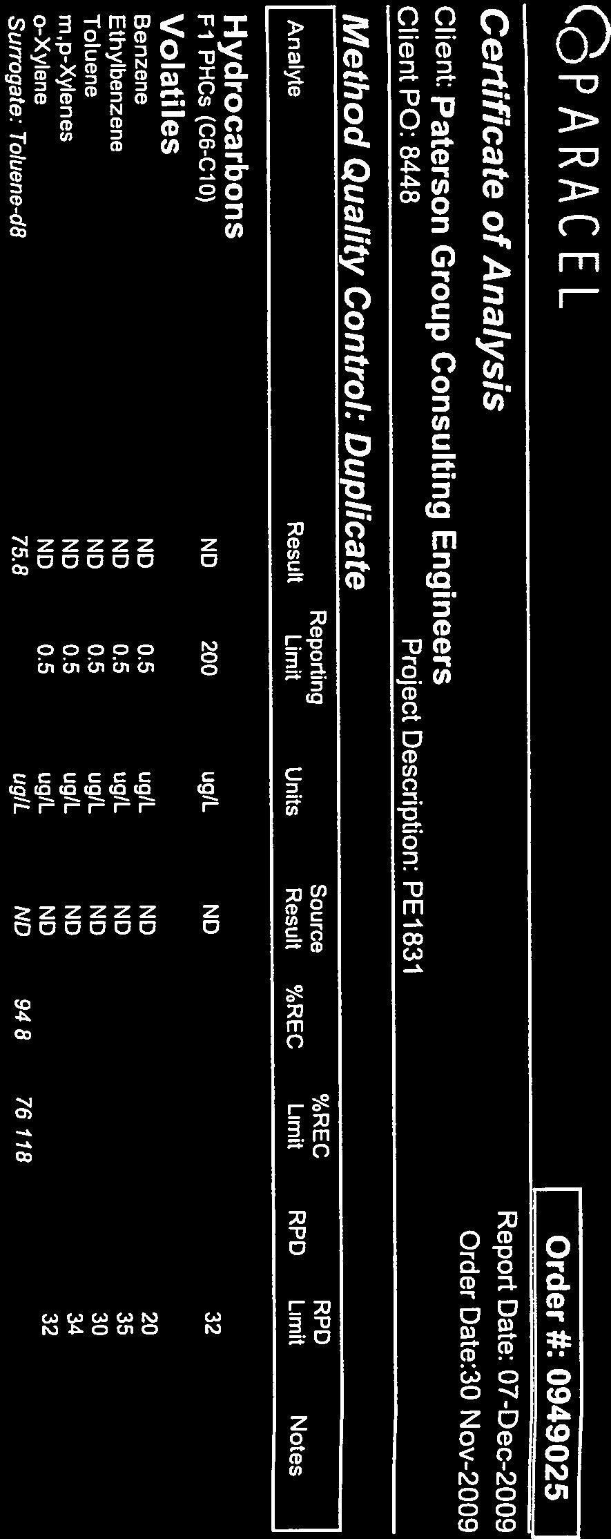

96


97


98

99
100 Certificate of Analysis Paterson Group Consulting Engineers 154 Colonnade Road South Nepean, ON K2E 7J5 Attn: Dan Arnott Phone: (613) Fax: (613) Client PO: Project: PE3003 Custody: Report Date: 22-May-2013 Order Date: 15-May-2013 This Certificate of Analysis contains analytical data applicable to the following samples as submitted: Paracel ID Client ID BH BH BH4-4 Order #: Approved By: Mark Foto, M.Sc. For Dale Robertson, BSc Laboratory Director Any use of these results implies your agreement that our total liabilty in connection with this work, however arising shall be limited to the amount paid by you for this work, and that our employees or agents shall not under circumstances be liable to you in connection with this work Page 1 of 7
101 Certificate of Analysis Client: Paterson Group Consulting Engineers Client PO: Analysis Summary Table Project Description: PE3003 Order #: Report Date: 22-May-2013 Order Date:15-May-2013 Analysis Method Reference/Description Extraction Date Analysis Date BTEX by P&T GC-MS EPA P&T GC-MS 17-May May-13 PHC F1 CWS Tier 1 - P&T GC-FID 17-May May-13 PHC F2 - F4 CWS Tier 1 - GC-FID, extraction 21-May May-13 Solids, % Gravimetric, calculation 22-May May-13 Page 2 of 7
102 Certificate of Analysis Order #: Report Date: 22-May-2013 Client: Paterson Group Consulting Engineers Order Date:15-May-2013 Client PO: Project Description: PE3003 Client ID: BH1-4 BH3-3 BH4-4 - Sample Date: 13-May May May-13 - Sample ID: MDL/Units Soil Soil Soil - Physical Characteristics % Solids 0.1 % by Wt Volatiles Benzene 0.02 ug/g dry <0.02 <0.02 < Ethylbenzene 0.05 ug/g dry < < Toluene 0.05 ug/g dry <0.05 <0.05 < m,p-xylenes 0.05 ug/g dry < < o-xylene 0.05 ug/g dry <0.05 <0.05 < Xylenes, total 0.05 ug/g dry < < Toluene-d8 Surrogate 110% 112% 111% - Hydrocarbons F1 PHCs (C6-C10) 7 ug/g dry <7 14 <7 - F2 PHCs (C10-C16) 4 ug/g dry <4 35 <4 - F3 PHCs (C16-C34) 8 ug/g dry 39 < F4 PHCs (C34-C50) 6 ug/g dry 50 < Page 3 of 7
103 Certificate of Analysis Client: Paterson Group Consulting Engineers Client PO: Method Quality Control: Blank Analyte Result Project Description: PE3003 Reporting Limit Units Hydrocarbons F1 PHCs (C6-C10) ND 7 ug/g F2 PHCs (C10-C16) ND 4 ug/g F3 PHCs (C16-C34) ND 8 ug/g F4 PHCs (C34-C50) ND 6 ug/g Volatiles Benzene ND 0.02 ug/g Ethylbenzene ND 0.05 ug/g Toluene ND 0.05 ug/g m,p-xylenes ND 0.05 ug/g o-xylene ND 0.05 ug/g Source Result %REC %REC Limit Xylenes, total ND 0.05 ug/g Surrogate: Toluene-d ug/g Order #: Report Date: 22-May-2013 Order Date:15-May-2013 RPD RPD Limit Notes Page 4 of 7
104 Certificate of Analysis Client: Paterson Group Consulting Engineers Client PO: Method Quality Control: Duplicate Analyte Hydrocarbons Result Project Description: PE3003 Reporting Limit Units Source Result F1 PHCs (C6-C10) ND 7 ug/g dry ND 40 F2 PHCs (C10-C16) 27 4 ug/g dry F3 PHCs (C16-C34) ug/g dry F4 PHCs (C34-C50) 74 6 ug/g dry Physical Characteristics % Solids % by Wt Volatiles Benzene ND 0.02 ug/g dry ND 50 Ethylbenzene ND 0.05 ug/g dry ND 50 Toluene ND 0.05 ug/g dry ND 50 m,p-xylenes ND 0.05 ug/g dry ND 50 o-xylene ND 0.05 ug/g dry ND 50 Surrogate: Toluene-d ug/g dry ND %REC %REC Limit Order #: Report Date: 22-May-2013 Order Date:15-May-2013 RPD RPD Limit Notes Page 5 of 7
105 Certificate of Analysis Client: Paterson Group Consulting Engineers Client PO: Method Quality Control: Spike Analyte Hydrocarbons Result Project Description: PE3003 Reporting Limit Units Source Result %REC %REC Limit Order #: Report Date: 22-May-2013 Order Date:15-May-2013 F1 PHCs (C6-C10) ug/g ND F2 PHCs (C10-C16) 85 4 ug/g QM-06 F3 PHCs (C16-C34) ug/g F4 PHCs (C34-C50) ug/g Volatiles Benzene ug/g ND Ethylbenzene ug/g ND Toluene ug/g ND m,p-xylenes ug/g ND o-xylene ug/g ND Surrogate: Toluene-d ug/g RPD RPD Limit Notes Page 6 of 7
106 Certificate of Analysis Client: Paterson Group Consulting Engineers Client PO: Qualifier Notes : QC Qualifiers : Project Description: PE3003 Order #: Report Date: 22-May-2013 Order Date:15-May-2013 QM-06 : QS-02 : Sample Data Revisions None Due to noted non-homogeneity of the QC sample matrix, the spike recoveries were out side the accepted range. Batch data accepted based on other QC. Spike level outside of control limits. Analysis batch accepted based on other QC included in the batch. Work Order Revisions / Comments : None Other Report Notes : n/a: not applicable ND: Not Detected MDL: Method Detection Limit Source Result: Data used as source for matrix and duplicate samples %REC: Percent recovery. RPD: Relative percent difference. Soil results are reported on a dry weight basis when the units are denoted with 'dry'. Where %Solids is reported, moisture loss includes the loss of volatile hydrocarbons. CCME PHC additional information: - The method for the analysis of PHCs complies with the Reference Method for the CWS PHC and is validated for use in the laboratory. All prescribed quality criteria identified in the method has been met. - F1 range corrected for BTEX. - F2 to F3 ranges corrected for appropriate PAHs where available. - The gravimetric heavy hydrocarbons (F4G) are not to be added to C6 to C50 hydrocarbons. - In the case where F4 and F4G are both reported, the greater of the two results is to be used for comparison to CWS PHC criteria. Page 7 of 7

107
108 Certificate of Analysis Paterson Group Consulting Engineers 154 Colonnade Road South Nepean, ON K2E 7J5 Attn: Dan Arnott Phone: (613) Fax: (613) Client PO: Project: PE3003 Custody: Report Date: 28-May-2013 Order Date: 22-May-2013 This Certificate of Analysis contains analytical data applicable to the following samples as submitted: Paracel ID Client ID BH1-13-GW BH3-13-GW DUPLICATE 1 Order #: Approved By: Mark Foto, M.Sc. For Dale Robertson, BSc Laboratory Director Any use of these results implies your agreement that our total liabilty in connection with this work, however arising shall be limited to the amount paid by you for this work, and that our employees or agents shall not under circumstances be liable to you in connection with this work Page 1 of 7
109 Certificate of Analysis Client: Paterson Group Consulting Engineers Client PO: Analysis Summary Table Project Description: PE3003 Order #: Report Date: 28-May-2013 Order Date:22-May-2013 Analysis Method Reference/Description Extraction Date Analysis Date BTEX by P&T GC-MS EPA P&T GC-MS 23-May May-13 PHC F1 CWS Tier 1 - P&T GC-FID 23-May May-13 PHC F2 - F4 CWS Tier 1 - GC-FID, extraction 24-May May-13 Page 2 of 7
110 Certificate of Analysis Client: Paterson Group Consulting Engineers Client PO: Project Description: PE3003 Order #: Report Date: 28-May-2013 Order Date:22-May-2013 Client ID: BH1-13-GW1 BH3-13-GW1 DUPLICATE 1 - Sample Date: 21-May May May-13 - Sample ID: MDL/Units Water Water Water - Volatiles Benzene 0.5 ug/l < Ethylbenzene 0.5 ug/l < Toluene 0.5 ug/l < m,p-xylenes 0.5 ug/l < o-xylene 0.5 ug/l < Xylenes, total 0.5 ug/l < Toluene-d8 Surrogate 118% 111% 111% - Hydrocarbons F1 PHCs (C6-C10) 25 ug/l F2 PHCs (C10-C16) 100 ug/l <100 <100 <100 - F3 PHCs (C16-C34) 100 ug/l <100 <100 <100 - F4 PHCs (C34-C50) 100 ug/l <100 <100 <100 - F1 + F2 PHCs 125 ug/l F1 + F2 PHCs 350 ug/l F3 + F4 PHCs 200 ug/l <200 <200 <200 - Page 3 of 7
111 Certificate of Analysis Client: Paterson Group Consulting Engineers Client PO: Method Quality Control: Blank Analyte Result Project Description: PE3003 Reporting Limit Units Hydrocarbons F1 PHCs (C6-C10) ND 25 ug/l F2 PHCs (C10-C16) ND 100 ug/l F3 PHCs (C16-C34) ND 100 ug/l F4 PHCs (C34-C50) ND 100 ug/l Volatiles Benzene ND 0.5 ug/l Ethylbenzene ND 0.5 ug/l Toluene ND 0.5 ug/l m,p-xylenes ND 0.5 ug/l o-xylene ND 0.5 ug/l Source Result %REC %REC Limit Xylenes, total ND 0.5 ug/l Surrogate: Toluene-d ug/l Order #: Report Date: 28-May-2013 Order Date:22-May-2013 RPD RPD Limit Notes Page 4 of 7
112 Certificate of Analysis Client: Paterson Group Consulting Engineers Client PO: Method Quality Control: Duplicate Analyte Result Project Description: PE3003 Reporting Limit Units Source Result Hydrocarbons F1 PHCs (C6-C10) ND 25 ug/l ND 30 Volatiles Benzene ND 0.5 ug/l ND 30 Ethylbenzene ND 0.5 ug/l ND 30 Toluene ND 0.5 ug/l ND 30 m,p-xylenes ND 0.5 ug/l ND 30 o-xylene ND 0.5 ug/l ND 30 Surrogate: Toluene-d ug/l ND %REC %REC Limit Order #: Report Date: 28-May-2013 Order Date:22-May-2013 RPD RPD Limit Notes Page 5 of 7
113 Certificate of Analysis Client: Paterson Group Consulting Engineers Client PO: Method Quality Control: Spike Analyte Hydrocarbons Result Project Description: PE3003 Reporting Limit Units Source Result %REC %REC Limit F1 PHCs (C6-C10) ug/l ND F2 PHCs (C10-C16) ug/l ND F3 PHCs (C16-C34) ug/l ND F4 PHCs (C34-C50) ug/l ND Volatiles Benzene ug/l ND Ethylbenzene ug/l ND Toluene ug/l ND m,p-xylenes ug/l ND o-xylene ug/l ND Surrogate: Toluene-d ug/l Order #: Report Date: 28-May-2013 Order Date:22-May-2013 RPD RPD Limit Notes Page 6 of 7
114 Certificate of Analysis Client: Paterson Group Consulting Engineers Client PO: Qualifier Notes : None Sample Data Revisions None Work Order Revisions / Comments : None Other Report Notes : Project Description: PE3003 Order #: Report Date: 28-May-2013 Order Date:22-May-2013 n/a: not applicable ND: Not Detected MDL: Method Detection Limit Source Result: Data used as source for matrix and duplicate samples %REC: Percent recovery. RPD: Relative percent difference. CCME PHC additional information: - The method for the analysis of PHCs complies with the Reference Method for the CWS PHC and is validated for use in the laboratory. All prescribed quality criteria identified in the method has been met. - F1 range corrected for BTEX. - F2 to F3 ranges corrected for appropriate PAHs where available. - The gravimetric heavy hydrocarbons (F4G) are not to be added to C6 to C50 hydrocarbons. - In the case where F4 and F4G are both reported, the greater of the two results is to be used for comparison to CWS PHC criteria. Page 7 of 7

115
patersongroup Phase II-Environmental Site Assessment 135 Barrette Street Ottawa, Ontario Prepared For Linebox Studio Inc.
 Geotechnical Engineering patersongroup Environmental Engineering Hydrogeology Geological Engineering Materials Testing Building Science Phase IIEnvironmental Site Assessment 135 Barrette Street Ottawa,
patersongroup Phase II Environmental Site Assessment Commercial Property 890 and 900 Bank Street Ottawa, Ontario Prepared For Canderel Management Inc.
 Geotechnical Engineering patersongroup Environmental Engineering Hydrogeology Geological Engineering Materials Testing Building Science Phase II Environmental Site Assessment Commercial Property 890 and
Fproduct. patersongroup. Phase II-Environmental Site Assessment Proposed Mixed Use Development 137 Bay Street and 350 Sparks Street Ottawa, Ontario
 Geotechnical Engineering patersongroup Fproduct Environmental Engineering Hydrogeology Geological Engineering Materials Testing Building Science Phase IIEnvironmental Site Assessment Proposed Mixed Use
patersongroup Phase I - Environmental Site Assessment Vacant Land, Strandherd Drive at Kennevale Drive Ottawa, Ontario Prepared For Regional Group
 Geotechnical Engineering patersongroup Environmental Engineering Hydrogeology Geological Engineering Materials Testing Building Science Vacant Land, Strandherd Drive at Kennevale Drive Ottawa, Ontario
patersongroup Phase II-Environmental Site Assessment Existing Commercial Property 852 Bank Street Ottawa, Ontario Prepared For
 Geotechnical Engineering patersongroup Environmental Engineering Hydrogeology Geological Engineering Materials Testing Building Science Phase IIEnvironmental Site Assessment Existing Commercial Property
patersongroup Consulting Engineers October 7, 2010 File: PE2100-LET.01 Springcress Properties Inc. 6 Gurdwara Road, Suite 200 Ottawa, Ontario K2E 8A3
 patersongroup Consulting Engineers 28 Concourse Gate, Unit 1 Ottawa, Ontario Canada, K2E 7T7 Tel: (613) 2267381 Fax: (613) 2266344 October 7, 2010 File: PE2100LET.01 Springcress Properties Inc. 6 Gurdwara
the former Honeywell plant building (3 Hamilton Avenue) a single-storey brick industrial/commercial building (233 Armstrong Street)
 a single-storey brick industrial/commercial building (233 Armstrong Street)") consulting engineers memorandum to: Tega Developments - Mr. Spyro Dimitrakopoulos - spyro@tegadevelopments.com re: Environmental Remedial Action Plan Proposed Residential Building 233 Armstrong Street
consulting engineers memorandum to: Tega Developments - Mr. Spyro Dimitrakopoulos - spyro@tegadevelopments.com re: Environmental Remedial Action Plan Proposed Residential Building 233 Armstrong Street
Phase Two Environmental Site Assessment
 Phase Two Environmental Site Assessment Project Address: 671 River Road, Ottawa, Ontario Client: Shoppers Drug Mart, Inc. 243 Consumers Road North York, Ontario M2J 4W8 Project Number: OTT-00221164-D0
Fsub. patersongroup. Phase II - Environmental Site Assessment Vacant Property 900 Albert Street Ottawa, Ontario. Prepared For
 Geotechnical Engineering Fsub Environmental Engineering Hydrogeology Geological Engineering Materials Testing Building Science Phase II - Environmental Site Assessment Vacant Property 900 Albert Street
SUPPLEMENTAL PHASE II ENVIRONMENTAL SITE ASSESSMENT APPLEBY MALL 5111 NEW STREET AND 499 & 505 APPLEBY LINE BURLINGTON, ONTARIO
 SUPPLEMENTAL PHASE II ENVIRONMENTAL SITE ASSESSMENT APPLEBY MALL 5111 NEW STREET AND 499 & 505 APPLEBY LINE BURLINGTON, ONTARIO SUPPLEMENTAL PHASE II ENVIRONMENTAL SITE ASSESSMENT APPLEBY MALL 5111 NEW
patersongroup Potable Water Supply Assessment Commercial Site Development 4139 Moodie Drive Ottawa, Ontario Prepared For
 Geotechnical Engineering patersongroup Environmental Engineering Hydrogeology Geological Engineering Materials Testing Building Science Potable Water Supply Assessment Commercial Site Development 4139
patersongroup Phase II Environmental Site Assessment 383 Albert Street and 340 Queen Street Ottawa, Ontario Prepared For Claridge Homes August 3, 2018
 Geotechnical Engineering patersongroup Environmental Engineering Hydrogeology Geological Engineering Materials Testing Phase II Environmental Site Assessment 383 Albert Street and 340 Queen Street Ottawa,
Jindal Developments Ltd.
 1965, 1975, 1985 Cottrelle Boulevard, Brampton, Ontario Type of Document Final Project Name Phase Two ESA Project Number Prepared By: EXP 1595 Clark Boulevard Brampton, ON L6T 4V1 Canada Date Submitted
PHASE II ENVIRONMENTAL SITE ASSESSMENT CAPONE S RESTAURANT 831 INDUSTRIAL AVENUE OTTAWA, ONTARIO
 PHASE II ENVIRONMENTAL SITE AEMENT CAPONE S RESTAURANT 831 INDUSTRIAL AVENUE OTTAWA, ONTARIO Prepared for: Huntington Capital Corporation 260 Hearst Way, suite 300 Kanata, Ontario K2J 3HL Pinchin Environmental
August 28, 2018 File: PE2122-LET.01
 patersongroup August 28, 2018 File: PE2122-LET.01 Minto Communities 200-180 Kent Street Ottawa, Ontario K1P 0B6 Attention: Mr. Kevin Harper Consulting Engineers 154 Colonnade Road South Ottawa, Ontario
Phase II Environmental Site Assessment
 Phase II Environmental Site Assessment 59 Industrial Park Crescent Sault Ste. Marie, Ontario Paddon and Yorke Inc. 222 McIntyre Street West, Suite 204 Sault Ste. Marie, ON P1B 2Y8 Attention: Mr. Ken Peake
Reference: OTCD B 17 September Soil Sampling Program th Line Road, Metcalfe, ON
 Trow Associates Inc. 154 Colonnade Road South Ottawa, Ontario K2E 7J5 Telephone: (613) 225-9940 Facsimile: (613) 225-7337 E-mail: ottawa@trow.com Web Site: www.trow.com Reference: OTCD00019239B 17 September
APPLICATION OF SUBSURFACE VAPOUR ASSESSMENT AT HYDROCARBON IMPACTED SITES
 APPLICATION OF SUBSURFACE VAPOUR ASSESSMENT AT HYDROCARBON IMPACTED SITES Mitch Kenaschuk, P.Eng. Peter Olmsted, M.Sc.,P.Eng. October 2004 OUTLINE Introduction Regulatory Framework and Methodology Vapour
Conceptual Site Models for Environmental Investigations and Remediation
 Remediation Technology Symposium (RemTech) 2012 Conceptual Site Models for Environmental Investigations and Remediation October 18, 2012 Tai T. Wong, P.Eng. Authors and Presenter Authors: James Carss,
1375 CLYDE AVENUE, NEPEAN, ON PHASE II ENVIRONMENTAL SITE ASSESSMENT ENGINEERING LABORATORY. 400 Esna Park Drive, Unit 15 Markham, ON L3R 3K2
 ENGINEERING LABORATORY PHASE II ENVIRONMENTAL SITE ASSESSMENT 1375 CLYDE AVENUE, NEPEAN, ON 400 Esna Park Drive, Unit 15 Markham, ON L3R 3K2 Tel: (905) 475-7755 Fax: (905) 475-7718 www.fisherenvironmental.com
Phase II Environmental Site Assessment Update 112 Montreal Road, Ottawa, Ontario
 Phase II Environmental Site Assessment Update 112 Montreal Road, Ottawa, Ontario Client 1147310 Ontario Incorporated 7 Strathearn Avenue Brampton, Ontario L6T 4P1 Project Number: OTT00214936B0 Prepared
SNC-LAVALIN INC. FINAL REPORT PHASE TWO ENVIRONMENTAL SITE AREA OF PROPOSED FUTURE DEVELOPMENT, NORTHERN PORTION OF 1951 CYRVILLE ROAD, OTTAWA, ON
 FINAL REPORT PHASE TWO ENVIRONMENTAL SITE TITLE ASSESSMENT AREA OF PROPOSED FUTURE DEVELOPMENT, NORTHERN PORTION OF 1951 CYRVILLE ROAD, OTTAWA, ON City of Ottawa SNCLAVALIN INC. March 2016 FINAL REPORT
patersongroup Phase I Environmental Site Assessment Vacant, Undeveloped Land 1021 Thomas Spratt Place Ottawa, Ontario Prepared For
 Geotechnical Engineering patersongroup Environmental Engineering Hydrogeology Geological Engineering Materials Testing Building Science Phase I Environmental Site Assessment Vacant, Undeveloped Land 1021
patersongroup Background Consulting Engineers May 26, 2017 Report: PG3914-LET.01R
 patersongroup May, 07 Report: PG9-LET.0R 0770 Ontario Inc. (Manor Park Management in Trust) c/o Momentum Greenlawn Crescent Ottawa, Ontario KC Z Consulting Engineers Colonnade Road South Ottawa, Ontario
Phase II Environmental Site Assessment 173 Huntmar Drive, Ottawa, Ontario
 Phase II Environmental ite Assessment 173 Huntmar Drive, Ottawa, Ontario Type of Document Final Client 1 Jeremiah Place Ottawa, Ontario K2H 8L7 Project Number: Prepared By: Taryn Glancy, M.A.c. Reviewed
Soil Remediation and Verification Sampling Program 18 Main Street St. Eustache, Manitoba
 Soil Remediation and Verification Sampling Program 18 Main Street St. Eustache, Manitoba Business Development Bank of Canada Suite 200, 1655 Kenaston Boulevard Winnipeg, Manitoba R3P 2M4 Attention: Mr.
patersongroup Phase I - Environmental Site Assessment Proposed Cardinal Creek Village Subdivision Lands Old Montreal Road Ottawa (Cumberland), Ontario
, Ontario") Geotechnical Engineering patersongroup Environmental Engineering Hydrogeology Geological Engineering Materials Testing Archaeological Studies Building Science Proposed Cardinal Creek Village Subdivision
Geotechnical Engineering patersongroup Environmental Engineering Hydrogeology Geological Engineering Materials Testing Archaeological Studies Building Science Proposed Cardinal Creek Village Subdivision
patersongroup Phase I Environmental Site Assessment Commercial Property 890 and 900 Bank Street Ottawa, Ontario Prepared For Canderel Management Inc.
 Geotechnical Engineering patersongroup Environmental Engineering Hydrogeology Geological Engineering Materials Testing Building Science Phase I Environmental Site Assessment Commercial Property 890 and
Phase Two Environmental Site Assessment. 770 Somerset Street West Ottawa, Ontario Prepared For: DCR Phoenix Group
 Phase Two Environmental Site Assessment 770 Somerset Street West Ottawa, Ontario Prepared For: DCR Phoenix Group December 2012 14-12815-001-PH2 December 12, 2012 14-12815-001-PH1 Mr. Michael Boucher Manager
Phase Two Environmental Site Assessment 2887 Riverside Drive Ottawa, Ontario
 Phase Two Environmental Site Assessment 2887 Riverside Drive Ottawa, Ontario Submitted to: Cahdco 200415 Gilmour Street Ottawa, Ontario K1P 5W8 Phase Two Environmental Site Assessment Proposed Youth Hub
PHASE TWO ENVIRONMENTAL SITE ASSESSMENT 89 BEECHWOOD AVENUE GUELPH, ONTARIO
 PHASE TWO ENVIRONMENTAL SITE ASSESSMENT 89 BEECHWOOD AVENUE GUELPH, ONTARIO SUBMITTED TO: Mr. Pete Graham 89 Beechwood Inc. c/o Acorn Developments 80 Southgate Drive Guelph, Ontario N1G 4P5 FILE NO.: E16318
Case Studies in Risk Management Methods as a Component of the Remedial Process
 Case Studies in Risk Management Methods as a Component of the Remedial Process Cecile Willert, P.Eng., QP RA January/February 2013 Agenda Issues Summary Case Study # 1 RA of DNAPL site (combined with remediation)
Submitted to: Glen Smith, Director of Public Works & Parks Township of Scugog 181 Perry Street Port Perry, Ontario L9L 1A7
 LIMITED SUBSURFACE ENVIRONMENTAL INVESTIGATION, GREENBANK AIRPORT, 114 HIGHWAY 47 EAST, UXBRIDGE, ONTARIO Submitted to: Glen Smith, Director of Public Works & Parks Township of Scugog 181 Perry Street
Figure 1 illustrates the location of the Site and Figure 2 illustrates the Site layout, including borehole locations.
 1.0 Introduction Stantec Consulting Ltd. (Stantec) was retained by Mr. John Doe, on behalf of The Client to conduct a Phase II Environmental Site Assessment (ESA) at a property located at 151 Main Street,
October 27, Dundas Corporation 2184 Providence Road Oakville, Ontario L6H 6Z2
 October 27, 2014 14-122 103 Dundas Corporation 2184 Providence Road Oakville, Ontario L6H 6Z2 Attention: Re: Mr. Zaki Wahbeh Soil and Groundwater Testing 103 Dundas Street West, Oakville, Ontario Dear
PHASE TWO ENVIRONMENTAL SITE ASSESSMENT PROPOSED RESIDENTIAL DEVELOPMENT DERRY ROAD AND REGIONAL ROAD #25 MILTON, ONTARIO
 PHASE TWO ENVIRONMENTAL SITE AEMENT PROPOSED RESIDENTIAL DEVELOPMENT DERRY ROAD AND REGIONAL ROAD #25 MILTON, ONTARIO Prepared for: BRIARWOOD GROUP 636 Edward Avenue, Unit 14 Richmond Hill, ON L4C 0V4
PHASE TWO ENVIRONMENTAL SITE ASSESSMENT
 METROPIA PHASE TWO ENVIRONMENTAL SITE ASSESSMENT 1856 NOTION ROAD, PICKERING, ONTARIO, CANADA OCTOBER 16, 2017 PHASE TWO ENVIRONMENTAL SITE ASSESSMENT 1856 NOTION ROAD, PICKERING, ONTARIO, CANADA METROPIA
Phase II Environmental Site Assessment
 Phase II Environmental Site Assessment 8 No. 3 Sideroad Milton, Ontario Royal Park Homes c/o Shad & Associates Inc. 83 Citation Drive, Unit 9 Vaughan, ON, L4K 2Z6 Attention: Mr. Doug Skeffington May 6,
Terraprobe Consulting Geotechnical & Environmental Engineering Construction Materials Engineering, Inspection & Testing
 Terraprobe Consulting Geotechnical & Environmental Engineering Construction Materials Engineering, Inspection & Testing PRELIMINARY SUBSURFACE INVESTIGATION TTC LFLRV MAINTENANCE & STORAGE FACILITIES LAKESHORE
Sump Pump Feasibility Review Summerside West Residential Development - Phases 4, 5 and 6 Tenth Line Road - Ottawa, Ontario
 May 24, 2018 File: PG4049-LET.03 Mattamy Homes 50 Hines Road, Suite 100 Ottawa, Ontario K2K 2M5 Consulting Engineers 154 Colonnade Road South Ottawa, Ontario Canada, K2E 7J5 Tel: (613) 226-7381 Fax: (613)
P Temporary piezometer. MW Piezometer to remain in place. P Temporary piezometer
 2. Field Program 2.1 Health and Safety Plan Prior to beginning the field program, CH2M HILL developed a health and safety plan (H&SP). The H&SP provided a summary of potential physical hazards that could
This report updates a Phase I-Environmental Site Assessment report prepared by Paterson, dated March 2008, as detailed below.
 Consulting Engineers October 13, 2016 Bassi Construction 2575 Del Zotto Avenue Ottawa, Ontario K1T 3V7 Attention: Subject: Phase I - Environmental Site Assessment Update Residential and Vacant Property
April 7, Webster Street Sub-Surface Stormwater Storage System Bid No Bid Date: 4/13/17 ADDENDUM NO 1
 PUBLIC WORKS DEPARTMENT David A. Jones, P.E., Director April 7, 2017 Webster Street Sub-Surface Stormwater Storage System Bid No. 2017-022 Bid Date: 4/13/17 ADDENDUM NO 1 Please make the following changes
TOWNSHIP OF NORTH GLENGARRY MAXVILLE COMMUNAL SEWAGE LAGOONS 2011 GROUNDWATER AND SURFACE WATER MONITORING PROGRAM REF.: FINAL REPORT
 2011 Groundwater and Surface Water Monitoring Program FINAL REPORT TOWNSHIP OF NORTH GLENGARRY MAXVILLE COMMUNAL SEWAGE LAGOONS 2011 GROUNDWATER AND SURFACE WATER MONITORING PROGRAM REF.: 09-511 Submitted:
FINAL Phase Two Environmental Site Assessment 1276, 1280, 1288, 1290 & 1294 Wharf Street and 607 Annland Street Pickering, Ontario
 FINAL Phase Two Environmental Site Assessment 1276, 1280, 1288, 1290 & 1294 Wharf Street and 607 Annland Street Pickering, Ontario Prepared for: R.B Morgan Construction 1289 Wharf Street Pickering, Ontario,
patersongroup Prepared For C. Fleming Developments Ltd. November 14, 2005 Report: PE0644-1
 Geotechnical Engineering patersongroup Environmental Engineering Hydrogeology Geological Engineering Materials Testing Building Science Mer Bleue Road and Tenth Line Road Prepared For C. Fleming Developments
patersongroup Phase I - Environmental Site Assessment Retirement Home Colonial Road Ottawa (Sarsfield), Ontario Prepared For
, Ontario Prepared For") Geotechnical Engineering patersongroup Environmental Engineering Hydrogeology Geological Engineering Materials Testing Building Science Archeological Studies Retirement Home - 2980 Colonial Road Ottawa
Geotechnical Engineering patersongroup Environmental Engineering Hydrogeology Geological Engineering Materials Testing Building Science Archeological Studies Retirement Home - 2980 Colonial Road Ottawa
patersongroup 1.0 Field Investigation Consulting Engineers December 14, 2015 PG3700-LET.01
 December 14, 2015 1828486 Ontario Limited 277 Kirchoffer Avenue Ottawa, ON K2A 1Y1 Attention: Subject: Mr. Rolf Bauman Geotechnical Investigation Proposed Residential Buildings 890 Greenbriar Avenue -
PHASE II ENVIRONMENTAL SITE ASSESSMENT
 PHASE II ENVIRONMENTAL SITE ASSESSMENT 1284 GUELPH LINE, BURLINGTON ONTARIO December 5, 2014 Prepared by: SWAP Services Inc. Prepared for: A.J. Clarke and Associates Ltd. 25 Main Street West, Suite 300
Phase II Environmental Site Assessment
 Phase II Environmental Site Assessment 3654 & 3658 Jockvale Road, Ottawa, Ontario Prepared For: Phoenix Homes 18A Bentley Avenue Ottawa, Ontario K2E 6T8 Trow Associates Inc. 154 Colonnade Road South Ottawa,
patersongroup Phase I - Environmental Site Assessment 538, 544 & 560 Rideau Street and 501 Besserer Street Ottawa, Ontario Prepared For
 Geotechnical Engineering Environmental Engineering Hydrogeology Geological Engineering Materials Testing Building Science 538, 544 & 560 Rideau Street and 501 Besserer Street Ottawa, Ontario Archaeological
Phase II Environmental Site Assessment (ESA) Update. Bernard Benoit Project Management (BBPM) 2212 Gladwin Crescent, Unit B4 Ottawa, Ontario K1B 5N1
 Update. Bernard Benoit Project Management (BBPM) 2212 Gladwin Crescent, Unit B4 Ottawa, Ontario K1B 5N1") Phase II Environmental Site Assessment (ESA) Update 2720 Richmond Road Bernard Benoit Project Management (BBPM) 2212 Gladwin Crescent, Unit B4 K1B 5N1 Centre Multiservices Francophone de l Ouest d Ottawa
Phase II Environmental Site Assessment (ESA) Update 2720 Richmond Road Bernard Benoit Project Management (BBPM) 2212 Gladwin Crescent, Unit B4 K1B 5N1 Centre Multiservices Francophone de l Ouest d Ottawa
June i TABLE OF CONTENTS
 June 2005 - i - 05-526 TABLE OF CONTENTS SECTION PAGE 1.0 INTRODUCTION... 1 1.1 Purpose of the Investigation... 1 1.2 Description of the Project and Scope of Work... 1 1.3 Site Geology... 1 1.4 Site Description
patersongroup Geotechnical Investigation Proposed Residential Development 3071 Riverside Drive Ottawa, Ontario Prepared For Canoe Bay Development Inc.
 Geotechnical Engineering Environmental Engineering Hydrogeology Geological Engineering Materials Testing Building Science Archaeological Services Proposed Residential Development 3071 Riverside Drive Ottawa,
Ontario Ministry of the Environment - Record of Site Condition # Record of Site Condition Under Part XV.1 of the Environment Protection Act
 Ontario Ministry of the Environment - Record of Site Condition # 211208 Record of Site Condition Under Part XV.1 of the Environment Protection Act Summary Record of Site Condition Number 211208 Date Filed
paterson -MEMO consulting engineers
 paterson consulting engineers EMAIL-MEMO to: Minto Communities Inc. - Mr. Barry Gray bgray@minto.com cc: Minto Communities Inc. - Mr. Julio Da Silva julio_dasilva@minto.com re: Grade Raise Recommendations
patersongroup Geotechnical Investigation Proposed Automotive Dealerships 200 Dibblee Road Ottawa, Ontario Prepared For Dilawri Holdings
 Geotechnical Engineering patersongroup Environmental Engineering Hydrogeology Geological Engineering Materials Testing Building Science Geotechnical Investigation Proposed Automotive Dealerships Dibblee
2650 Queensview Drive Ottawa, Ontario, K2B 8H6, CANADA T: Proposed Development, 1158 Second Line Road, Ottawa, ON
 2650 Queensview Drive Ottawa, Ontario, K2B 8H6, CANADA T: 1.613.688.1899 www.exp.com March 13, 2018 Mr. Joey Theberge Theberge Homes Ltd. 904 Lady Ellen Place Ottawa, Ontario K1Z 5L5 Via Email: joeytheberge@thebergehomes.com
RISK MANAGEMENT OF A FORMER SALT STORAGE YARD
 RISK MANAGEMENT OF A FORMER SALT STORAGE YARD Robert S. Nichols, B.Sc., P.Eng. and Trent Parks, Ph.D., P.Chem. Abstract A risk management plan was developed by Matrix Solutions Inc. (Matrix) and implemented
Guidance Document Risk-Based Corrective Action (RBCA) For Residential and Commercial Heating Oil Systems. National Oilheat Research Alliance (NORA)
 For Residential and Commercial Heating Oil Systems. National Oilheat Research Alliance (NORA)") Guidance Document Risk-Based Corrective Action (RBCA) For Residential and Commercial National Oilheat Research Alliance (NORA) Forward Heating oil is used to heat many private homes as well as small commercial
Guidance Document Risk-Based Corrective Action (RBCA) For Residential and Commercial National Oilheat Research Alliance (NORA) Forward Heating oil is used to heat many private homes as well as small commercial
Ontario Ministry of the Environment and Climate Change - Record of Site Condition #
 Ontario Ministry of the Environment and Climate Change - Record of Site Condition # 221548 Record of Site Condition Under Part XV.1 of the Environment Protection Act Summary Record of Site Condition Number
PHASE TWO ENVIRONMENTAL SITE ASSESSMENT
 PHASE TWO ENVIRONMENTAL SITE ASSESSMENT at 747 Liverpool Road, Pickering, Ontario Prepared for Madison Liverpool Limited CCIG Project No: T1685EN CCIG Contact: Bob Gordanifar, P.Eng., QP ESA and RA bobg@ccigroupinc.ca
atertech Banff, AB. April 29-May 1, 2009
 DILUTION IS NOT A SALT SOLUTION Case Studies: Assessment, Containment and Recovery of Two Produced Water Spills into Domestic Use Aquifers in Central Alberta 2 AUTHORS Randy Brunatti and Reed Jackson AMEC
address, Ontario Pinchin File:
 Phase Two Environmental Site Assessment DRAFT company date address, Ontario Pinchin File: 48048.004 Phase Two Environmental Site Assessment 288 and 420 Bayshore Drive Midland, Ontario Unimin Canada Ltd.
Reference Guideline #1. Hydrogeological Impact Assessment
 Reference Guideline #1 Hydrogeological Impact Assessment Reference Guideline #1 Hydrogeological Impact Assessment Hydrogeological assessments are required for some subdivision applications when triggered
British Columbia s New Guidance for Groundwater Site Characterization
 Guy C. Patrick Victoria, BC October 29, 2010 British Columbia s New Guidance for Groundwater Site Characterization Better Investigations for Better Decision Making BC Ministry of Environment, 2010. Technical
patersongroup Geotechnical Investigation Proposed Commercial Building 1989 Merivale Road Ottawa, Ontario Prepared For Zic s Holdings June 30, 2016
 Geotechnical Engineering patersongroup Environmental Engineering Hydrogeology Geological Engineering Materials Testing Building Science Proposed Commercial Building 989 Merivale Road Ottawa, Ontario Archaeological
FACTS ABOUT: Former GE Power Systems Apparatus Service Center (Voluntary Cleanup Program) Site Location
 Site Location") Maryland Department of the Environment Site Location FACTS ABOUT: Former GE Power Systems Apparatus Service Center (Voluntary Cleanup Program) This 2.4581-acres site (Site) consists of four parcels of
Maryland Department of the Environment Site Location FACTS ABOUT: Former GE Power Systems Apparatus Service Center (Voluntary Cleanup Program) This 2.4581-acres site (Site) consists of four parcels of
patersongroup 1.0 Field Investigation Consulting Engineers February 8, 2016 Report: PG Doran Contractors Limited 3187 Albion Road South
 February 8, 016 Report: PG717-1 Doran Contractors Limited 187 Albion Road South Ottawa, Ontario K1V 8Y Attention: Subject: Mr. Sean Montgomery Geotechnical Investigation Proposed Commercial Development
patersongroup Phase I Environmental Site Assessment Vacant Property 3735 St. Joseph Boulevard Ottawa, Ontario Prepared For Mr.
 Geotechnical Engineering patersongroup Environmental Engineering Hydrogeology Geological Engineering Materials Testing Building Science Phase I Environmental Site Assessment Vacant Property 3735 St. Joseph
GAMSBY AND MANNEROW Limited CONSULTING PROFESSIONAL ENGINEERS GUELPH- OWEN SOUND- LISTOWEL
 GAMSBY AND MANNEROW Limited GUELPH- OWEN SOUND- LISTOWEL 255 WOODLAWN ROAD WEST, SUITE 210 GUELPH, ONTARIO, N1H 8)1 PHONE (519) 824-8150 FAX (519) 824-8089 email: info@gamsby.com February 22, 2005 Our
patersongroup Geotechnical Investigation Proposed Development Palladium Drive at Huntmar Drive Ottawa, Ontario Prepared For Ontario Inc.
 Geotechnical Engineering patersongroup Environmental Engineering Hydrogeology Geological Engineering Materials Testing Building Science Archaeological Services Proposed Development Palladium Drive at Huntmar
(this cover page left intentionally blank)
") 4. Siting the Well (this cover page left intentionally blank) 4. Siting the Well Chapter Table of Contents Chapter Table of Contents Chapter Description... 4 Regulatory Requirements Well Siting... 4 Relevant
4. Siting the Well (this cover page left intentionally blank) 4. Siting the Well Chapter Table of Contents Chapter Table of Contents Chapter Description... 4 Regulatory Requirements Well Siting... 4 Relevant
patersongroup 1.0 Field Observations Consulting Engineers June 9, 2010 File: PG2122-LET.01 Mar Gard Builders 92 Bentley Avenue Ottawa, Ontario K2E 6T9
 patersongroup June 9, 2010 Mar Gard Builders 92 Bentley Avenue Ottawa, Ontario K2E 6T9 Attention: Subject: Mr. Tony Miriani Geotechnical Investigation Proposed Commercial Development 4471 to 4487 Innes
REPORT ON PHASE I ENVIRONMENTAL SITE ASSESSMENT 1358 COKER STREET OSGOODE WARD, GREELY CITY OF OTTAWA, ONTARIO. Submitted to:
 Civil Geotechnical Structural Environmental Industrial Health & Safety 215 Sanders Street, Unit 1 (613) 860-0923 P.O. Box 189 Kemptville, Ontario K0G 1J0 FAX: (613) 258-0475 REPORT ON PHASE I ENVIRONMENTAL
patersongroup Consulting Engineers March 2, 2017 PH2948-LET.01R1 Phoenicia Development 4100 Albion Road Ottawa, Ontario K1T 3W1
 Consulting Engineers March 2, 2017 154 Colonnade Road Ottawa, Ontario Canada, K2E 7J5 Tel: (613) 226-7381 Fax: (613) 226-6344 Phoenicia Development 4100 Albion Road Ottawa, Ontario K1T 3W1 Attention: Subject:
DESIGN PARAMETERS FOR MULTI-PHASE EXTRACTION SYSTEMS USING UNSATURATED AND SATURATED SOIL PROPERTIES
 DESIGN PARAMETERS FOR MULTI-PHASE EXTRACTION SYSTEMS USING UNSATURATED AND SATURATED SOIL PROPERTIES Todd White, M.Sc., P.Geol. and Douglas A. Sweeney, M.Sc., P.Eng. SEACOR Environmental Inc. INTRODUCTION
patersongroup Consulting Engineers March 19, 2013 File: PE2927-LET.01 Broccolini Construction 130 Slater Street, Suite 1300 Ottawa, Ontario K1P 6E2
 patersongroup March 19, 2013 File: PE2927-LET.01 Broccolini Construction 130 Slater Street, Suite 1300 Ottawa, Ontario K1P 6E2 Attention: Mr. James Beach Consulting Engineers 154 Colonnade Road South Ottawa,
patersongroup Phase I - Environmental Site Assessment 450 Churchill Avenue North Ottawa, Ontario Prepared For Kitchissippi United Church March 8, 2010
 Geotechnical Engineering patersongroup Environmental Engineering Hydrogeology Geological Engineering Materials Testing 450 Churchill Avenue North Building Science Prepared For Kitchissippi United Church
patersongroup Phase I - Environmental Site Assessment Vacant Property 1034 McGarry Terrace and 1117 Longfields Drive Ottawa, Ontario Prepared For
 Geotechnical Engineering patersongroup Environmental Engineering Hydrogeology Geological Engineering Materials Testing Building Science Phase I - Environmental Site Assessment Vacant Property 1034 McGarry
Ontario Ministry of the Environment - Record of Site Condition # K8P 0C5
 Ontario Ministry of the Environment - Record of Site Condition # 214610 Record of Site Condition Under Part XV.1 of the Environment Protection Act Summary Record of Site Condition Number 214610 Date Filed
Residual LNAPL Remediation Using BOS 200 at Budget Rental Car Site in Louisville, Kentucky USA
 Residual Remediation Using BOS 200 at Budget Rental Car Site in Louisville, Kentucky USA Background Information Linebach Funkhouser, Inc. (LFI) personnel performed permanent closure, assessment and corrective
Ontario Ministry of the Environment and Climate Change - Record of Site Condition #
 Ontario Ministry of the Environment and Climate Change - Record of Site Condition # 219027 Record of Site Condition Under Part XV.1 of the Environment Protection Act Summary Record of Site Condition Number
FINAL Limited Phase II Environmental Site Assessment Joseph Wolfond Park West Guelph, Ontario
 FINAL Limited Phase II Environmental Site Assessment Joseph Wolfond Park West Guelph, Ontario Prepared for: City of Guelph 1 Carden Street Guelph, ON N1H 3A1 Attn: Mr. Prasoon Adhikari Environmental Engineer
Case Studies: Overcoming Annoying Contaminant Rebound Using Adsorptive Technologies. RemTech Banff, AB October 11, 2018 Kevin French
 Case Studies: Overcoming Annoying Contaminant Rebound Using Adsorptive Technologies RemTech Banff, AB October 11, 2018 Kevin French Presenter Kevin French, P.Eng Vice President, Vertex Environmental Inc.
15A NCAC 02C.0219 AQUIFER STORAGE AND RECOVERY WELLS (a) Aquifer Storage and Recovery Wells are used to inject potable water for the purposes of
 Aquifer Storage and Recovery Wells are used to inject potable water for the purposes of") 15A NCAC 02C.0219 AQUIFER STORAGE AND RECOVERY WELLS (a) Aquifer Storage and Recovery Wells are used to inject potable water for the purposes of subsurface storage and for later recovery of the injected
15A NCAC 02C.0219 AQUIFER STORAGE AND RECOVERY WELLS (a) Aquifer Storage and Recovery Wells are used to inject potable water for the purposes of subsurface storage and for later recovery of the injected
Phase I and II Environmental Site Assessment 5026 Bank Street Ottawa, Ontario
 Phase I and II Environmental Site Assessment 5026 Bank Street Ottawa, Ontario Prepared for: MacEwen Petroleum Ltd. Attn.: Ian McLean, Manager Marketing & Site Development 18 Adelaide Street, P.O. Box 100
Supplemental Phase II - Environmental Site Assessment Existing Commercial Property 175 Richmond Road - Ottawa
 patersongroup Consulting Engineers 28 Concourse Gate, Unit 1 Ottawa, Ontario Canada, K2E 7T7 Tel: (613) 2267381 Fax: (613) 2266344 October 19 2011 File: PE2357LET.01 Claridge Homes 2001 210 Gladstone Avenue
It is our understanding that a three storey residential building is being proposed for the aforementioned site and will have one basement level.
 patersongroup June 21, 2016 File: PG3838-LET.01 Claridge Homes 2001-210 Gladstone Avenue Ottawa, Ontario K2P 0Y6 Attention: Subject: Mr. Neil Malhotra Geotechnical Desktop Review Proposed Residential Building
LNAPL Recovery Using Vacuum Enhanced Technology. Theresa Ferguson, R.G. June 2014
 LNAPL Recovery Using Vacuum Enhanced Technology Theresa Ferguson, R.G. June 2014 Presentation Overview v LNAPL in the Subsurface v What is Vacuum Enhanced Technology? v Technology Description and Application
patersongroup Geotechnical Investigation Proposed Residential Buildings 1800 Baseline Road Ottawa, Ontario Prepared For Minto Communities
 Geotechnical Engineering patersongroup Environmental Engineering Hydrogeology Geological Engineering Materials Testing Building Science Proposed Residential Buildings 1800 Baseline Road Ottawa, Ontario
Vapor Extraction / Groundwater Extraction (VE/GE) System Initial Report
 System Initial Report") Vapor Extraction / Groundwater Extraction (VE/GE) System Initial Report Gasoline Fueling Station Royal Farms #96 500 Mechanics Valley Road North East, MD 21901 MDE OCP Case No. 2011-0729-CE Facility ID
Vapor Extraction / Groundwater Extraction (VE/GE) System Initial Report Gasoline Fueling Station Royal Farms #96 500 Mechanics Valley Road North East, MD 21901 MDE OCP Case No. 2011-0729-CE Facility ID
This report presents the findings of the subsurface exploration concerning the design of the taxiway rehabilitation. Description
 September 22, 2016 American Infrastructure Development, Inc. 3810 Northdale Boulevard, Suite 170 Tampa, Florida 33624 Attn: Mr. Mohsen Mohammadi, Ph.D., P.E. Senior Consultant Mob: (813) 244-6609 E-mail:
patersongroup Prepared For Taggart Group of Companies April 20, 2015 Report: PG Rev. 1
 Geotechnical Engineering patersongroup Environmental Engineering Hydrogeology Geological Engineering Materials Testing Building Science Archaeological Services Supplemental Geotechnical Investigation Proposed
HYDROLOGICAL REVIEW SUMMARY
 The form is to be completed by the Professional that prepared the Hydrological. Use of the form by the City of Toronto is not to be construed as verification of engineering/hydrological content. Refer
Preliminary Geotechnical Investigation
 Preliminary Geotechnical Investigation Urban Centre Wastewater Servicing Class Environmental Assessment Study Town of Erin, Ontario Prepared For: Ainley Group GeoPro Project No.: 16-1 Report Date: January,
15A NCAC 02C.0225 GROUNDWATER REMEDIATION WELLS (a) Groundwater Remediation Wells are used to inject additives, treated groundwater, or ambient air
 Groundwater Remediation Wells are used to inject additives, treated groundwater, or ambient air") 15A NCAC 02C.0225 GROUNDWATER REMEDIATION WELLS (a) Groundwater Remediation Wells are used to inject additives, treated groundwater, or ambient air for the treatment of contaminated soil or groundwater.
15A NCAC 02C.0225 GROUNDWATER REMEDIATION WELLS (a) Groundwater Remediation Wells are used to inject additives, treated groundwater, or ambient air for the treatment of contaminated soil or groundwater.
REPORT OF GEOTECHNICAL EXPLORATION WEST MARJORY AVENUE TAMPA, FLORIDA
 REPORT OF GEOTECHNICAL EXPLORATION WEST MARJORY AVENUE TAMPA, FLORIDA AREHNA PROJECT NO. B-15-008 March 11, 2015 Prepared For: City of Tampa Stormwater Division 306 W. Jackson Street, 6N Tampa, Florida
Strength. Performance. Passion. Paris Pit CAP. April 30, Permit To Take Water Application Holcim (Canada) Inc.
 Inc.") Strength. Performance. Passion. Paris Pit CAP April 30, 2013 Permit To Take Water Application 2012 Holcim (Canada) Inc. Agenda Welcome Minutes from Last Meeting Dufferin Paris Pit - General Update Review
Strength. Performance. Passion. Paris Pit CAP April 30, 2013 Permit To Take Water Application 2012 Holcim (Canada) Inc. Agenda Welcome Minutes from Last Meeting Dufferin Paris Pit - General Update Review
General Groundwater Concepts
 General Groundwater Concepts Hydrologic Cycle All water on the surface of the earth and underground are part of the hydrologic cycle (Figure 1), driven by natural processes that constantly transform water