Influence of rainforest architectural and biological diversity on C assimilation along an elevation gradient in Hawaii
|
|
|
- Marjory Flowers
- 6 years ago
- Views:
Transcription


1 Influence of rainforest architectural and biological diversity on C assimilation along an elevation gradient in Hawaii Eben N. Broadbent PhD Candidate GREF Fellow Department of Biological Sciences, Stanford University Department of Global Ecology, Carnegie Institution

2 Outline 1. Overview 2. Primary research questions 3. Approach 4. Remote sensing 5. Study transect and site locations 6. Micro-climate measurements 7. Photosynthesis measurements 8. Model development and integration 9. Project status 10. Acknowledgements

3 Overview Carbon accumulation in plants is a major component of the global carbon cycle (~15 Pg C/year). Carbon dynamics will be altered by future climatic changes, including changes in temperature and precipitation. Carbon models have not included detailed 3-D maps of forest foliage distribution. Course scale estimates indicate that the inclusion of foliage profiles could result in ~50% differences in calculated GPP. Little understanding of the role architectural diversity vs. biological diversity may play in carbon dynamics, and especially under different environmental conditions. However, recent technological advancements are now making new research questions feasible.

4 Overarching research questions How does the inclusion of detailed forest structure alter modeled rates of forest C assimilation? How do architectural and biological diversity interact to define carbon assimilation under different temperature - precipitation regimes? Image courtesy CAO website detailed top of canopy rainforest structure and pigmentation

5 Approach

6 RS LiDAR / hyperspectral fusion Waveform light detection and ranging
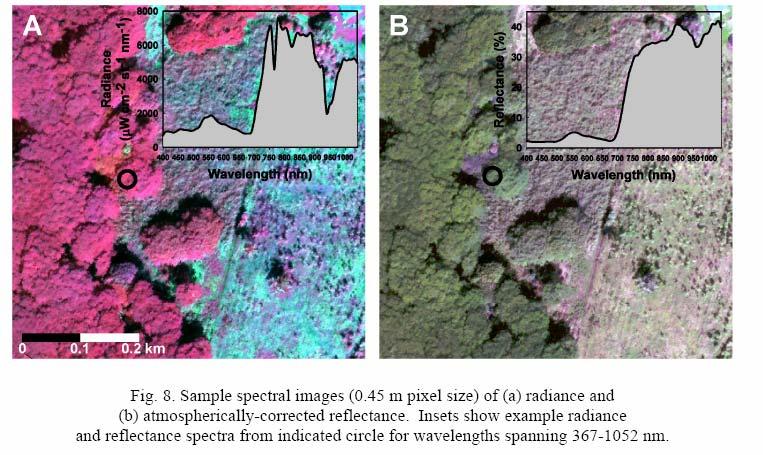
7 Hyperspectral imaging

8 Waveform LiDAR

9 Surface topography Image courtesy of Ty Kennedy-Bowdoin and the CAO

10 Max canopy height Image courtesy of Ty Kennedy-Bowdoin and the CAO
11 Example. Vertical forest leaf area density profile (red = high, blue = low, black = no biomass) Note voids in taller stature forest vertical profiles

12 Data fusion waveform + hyperspectral


13 Research site: Laupahoehoe, Big island, Hawaii

14 Laupahoehoe Experimental Forest Image courtesy of Ty Kennedy- Bowdoin


15 2.a Study transect location and description


16 Tree max canopy height distributions along the elevation transect T1: m T2: m T3: m T4: m


17 Changes in texture or horizontal architectural diversity
18 Definitions moving beyond tree height Vertical profiles Ex. Waveforms 2 Forest stature = height Low diversity High diversity Architecture = understory biomass
19 Definitions High Low Forest heterogeneity both in stature and architectural

20 Site locations The identification of study sites within the transect has the goal of sampling across both the elevation gradient and the dominant types of forest architecture. Input data: 1)Max canopy height 2)Forest architecture type 3)Canopy height variation 4)Elevation
 New data types and resolutions require new metrics and definitions. 2)How to define/quantify? a) Plan to transition common community population diversity metrics to forest architectural diversity.")
21 However, forest structure is complex in three dimensions and varies along the elevation gradient. So, leads to questions of: 1)What is forest architecture? a) New data types and resolutions require new metrics and definitions. 2)How to define/quantify? a) Plan to transition common community population diversity metrics to forest architectural diversity. 3)Categorical or continuous metrics? a) Determines statistical analyses and sampling designs.
22 Approach 1: categorical approach to quantifying forest architecture Height independent forest architectural categories % max canopy height A B C D E F Foliage density (% total LAD)* * In all cases, the summed area equals 100% vertical profile leaf area density (LAD

23 Architecture classified based on max LSU probability A=Red B=Green C=Blue D=Yellow E=Purple F=Magenta 36% 45% 13% Results from classification over study area Arch Type Pixels % A B C D 0 0 E F
24 Approach 2: looking for a continuous metric Canopy height variation Canopy height variation is defined as the difference in canopy height between a specified pixel (different scales) and the mean canopy height across 30 m sections of elevation gradient (i.e., m) within the study transect.
25 Does canopy height explain forest architecture? If canopy height (continuous variable) explains forest architectural type (categorical variable) I can locate my study plots along continuous gradients (elevation and deviation) versus replicating within a categorical variable. 300 points were randomly selected across the study transect and data exported to JMP. Mean canopy height significantly differed between dominant forest architectural categories.
26 Does elevation correlate with mean canopy height and/or height deviation? If mean canopy height and/or deviation is significantly related with elevation then fewer variables are necessary to consider when selecting study sites points were randomly selected across the study transect and data exported to JMP. Elevation explains max canopy height but does NOT explain height deviation. 5m example


27 Max height vs. height deviation Max canopy height Canopy height deviation
 within 3 elevation study zones.")
28 Study site selection Based on results only elevation and canopy height deviation are necessary gradients to sample for my study sites. I used a stratified random sampling method to identify low, mean and high deviation sites (10 m spatial resolution) within 3 elevation study zones. 5m example
 directly limits photosynthesis Wind speed controls")

 PAR +C02 + H20 => CH20 (e.")
29 Micro-climate measurements Direct and Diffuse PAR ( nm) directly limits photosynthesis Wind speed controls leaf transpiration rates Humidity controls leaf transpiration rates Temperature controls rates of enzyme catalysis Leaf water balance not measured as all rainfall is > 3000 mm yr-1 (not limiting) PAR +C02 + H20 => CH20 (e.g., sucrose) + 02


30 Top of canopy micro-climate Top of canopy weather stations are running simultaneously at low and high elevations of the transect. Data is collected every 30 seconds. Direct and diffuse PAR measurements will be collected at each location. 120 ft 60 ft


31 3. PAR: direct and diffuse dynamics Diurnal and seasonal pattern PAR sensor Hemi photo High arch. diversity Low arch. diversity


32 Diffuse / Direct PAR Important component of forest structure PAR interactions Direct and diffuse PAR penetrate forest interiors differently B / A = clearness index A B P A R P A R Isotrophic Anisotrophic

, Post processing models used to remove isotropic (sunny) and anistrophic (cloudy)")
33 How to make a shade ring - not as simple as it looks. Ring angle = latitude, PAR sensor position follows Earth polar axis, Offset varies with solar track; solstice = most severe offset, Sensor track positioned true North (solar noon highest sun elevation), Post processing models used to remove isotropic (sunny) and anistrophic (cloudy) errors resulting from the shade ring obscuring the sky.

34 Interior forest micro-climate Movable array (4 units) located randomly within study sites and location shifted weekly. Data collected same time scale as climate stations. Sensors calibrated with climate stations PAR Temp/rH Windspeed Canopy Logger Floor

35 Micro-climate and photosynthesis measurements Litterfall measurements Forest architecture measurements 20 m
36 Photosynthesis measurements 4-6 study sites per elevation zone will be selected based on canopy access. These will be used to set up traverses for in situ photosynthesis measurements throughout the upcoming year. Measurements will be made on the 5-8 dominant LAI species per site. Primary measurements will be photosynthesis under ambient conditions of PAR, temp and rh. A smaller number of PAR and temp response curves will be made for each species. For each photosynthesis measurement the following data will be recorded. Day Time of day Precise spatial location Species Individual max height Estimated leaf age (young, mid or old) All standard LiCOR 6400 output information A PAR or Temp Species A Species B 5m example


37 Canopy access

38 Modeling approach Structural model dealing with 201,600,000 LAD basketballs. Interior forest micro-climate will be modeled at a time scale of 1 minute throughout the study transect normalized to the top of canopy weather stations. Half of the interior forest micro-climate measurements will be used to parameterize the model and the other half to validate. Photosynthesis will be modeled using microclimate, structural location and climate station measurements as input data. The influence of species differences vs. forest architecture on total C assimilation will be quantified and compared.
39 Present status Fabricating and calibrating interior forest microclimate array, Fabricating and calibrating direct/diffuse PAR sensor system, Collecting vertical leaf profile data for LiDAR calibration, Rigging traverse locations, Calibrating and installing top of canopy climate stations. Prepping for a seasonal cycle (aka., year) of measurements starting ~ ~January 2009.


40 Some acknowledgements Project in collaboration with: Greg Asner, Angelica Almeyda, Dave Burke, Chris Field, Eric Davidson, Peter Vitousek, Susan Cordell, and Christian Giardina Assisted by: Flint Hughes, Joe Berry, Jen Funk, Robin Martin, Claire Lunch, Cameron Williams, Heraldo Farrington, Rodolfo Dirzo, Kate Brauman, David Freyberg, Ty Kennedy- Bowdoin, Dave Knapp, Jeff Broadbent, Taihaku Priest and many others. I thank the Stanford Department of Biology and Department of Anthropology, the Carnegie Institution Department of Global Ecology and DOE GCEP Fellowship for financial support. Thank you!
LiDAR based sampling for subtle change, developments, and status
 LiDAR based sampling for subtle change, developments, and status Erik Næsset Norwegian University of Life Sciences, Norway 2111 2005 Conclusions: 1. LiDAR is an extremely precise tool for measuring forest
Answer Test Questions Finish Climate Discussion
 NREM 301 Forest Ecology & Soils Day 30 December 4, 2008 Answer Test Questions Finish Climate Discussion Take-Home Test Due Dec 11 5 pm No Final Exam Lab Today Finish & e-mail all materials to Dick Class
Remote sensing: A suitable technology for crop insurance?
 Remote sensing: A suitable technology for crop insurance? Geospatial World Forum 2014 May 9, 2014, Geneva, Switzerland Agenda 1. Challenges using RS technology in crop insurance 2. Initial situation Dominance
UNEVEN-AGED MANAGEMENT NORTHWEST CERTIFIED FORESTRY
 UNEVEN-AGED MANAGEMENT NORTHWEST CERTIFIED FORESTRY Rolf Gersonde, 6/6/2015 Uneven-aged Management in 90 Minutes 2 Silviculture Background Forest Ecology Management Tools and Stocking Control Multi-aged
Dynamic Regional Carbon Budget Based on Multi-Scale Data-Model Fusion
 Dynamic Regional Carbon Budget Based on Multi-Scale Data-Model Fusion Mingkui Cao, Jiyuan Liu, Guirui Yu Institute Of Geographic Science and Natural Resource Research Chinese Academy of Sciences Toward
Estimating Leaf Bulk Density Distribution in a Tree Canopy Using Terrestrial LiDAR and a Straightforward Calibration Procedure
 Supplementary Information Estimating Leaf Bulk Density Distribution in a Tree Canopy Using Terrestrial LiDAR and a Straightforward Calibration Procedure Supplementary A. Inventory-Based Method to Estimate
Climate and Biodiversity
 LIVING IN THE ENVIRONMENT, 18e G. TYLER MILLER SCOTT E. SPOOLMAN 7 Climate and Biodiversity Core Case Study: A Temperate Deciduous Forest Why do forests grow in some areas and not others? Climate Tropical
On SEBI-SEBS validation in France, Italy, Spain, USA and China
 On SEBI-SEBS validation in France, Italy, Spain, USA and China Massimo Menenti Li Jia 2 and ZongBo Su 2 - Laboratoire des Sciences de l Image, de l Informatique et de la Télédétection (LSIIT), Strasbourg,
The Science Behind Quantifying Urban Forest Ecosystem Services. David J. Nowak USDA Forest Service Northern Research Station Syracuse, NY, USA
 The Science Behind Quantifying Urban Forest Ecosystem Services David J. Nowak USDA Forest Service Northern Research Station Syracuse, NY, USA Current Model Version 3.0 i-tree Version 4.0 (March 10, 2011)
Reducing Solar Performance Uncertainty. Presented by: Gwendalyn Bender, Head of Solar Product Development
 Reducing Solar Performance Uncertainty Presented by: Gwendalyn Bender, Head of Solar Product Development Vaisala Measurement, Assessment, Forecasting Over 80 years helping industries manage the impact
Fire History in the Colorado Rockies
 Fire History in the Colorado Rockies Brief overview of fire regimes in different forest ecosystem types Relationship of wildfire activity to climate variability Effects of fire exclusion and fire suppression
GeoCarb. PI: Berrien OU (Leadership, science analysis)
") PI: Berrien Moore @ OU (Leadership, science analysis) Partner Institutions: Lockheed-Martin (instrument) CSU (Algorithms) NASA Ames (Validation) GeoCarb A NASA Earth-Ventures mission, awarded in Dec 2016,
PI: Berrien Moore @ OU (Leadership, science analysis) Partner Institutions: Lockheed-Martin (instrument) CSU (Algorithms) NASA Ames (Validation) GeoCarb A NASA Earth-Ventures mission, awarded in Dec 2016,
The Earth s Global Energy Balance
 The Earth s Global Energy Balance Electromagnetic Radiation Insolation over the Globe World Latitude Zones Composition of the Atmosphere Sensible Heat and Latent Heat Transfer The Global Energy System
Wind flow and microclimate in vineyards and their impact on spore and pest dispersion and vineyard epidemiology. Rob Stoll University of Utah
 Wind flow and microclimate in vineyards and their impact on spore and pest dispersion and vineyard epidemiology Rob Stoll University of Utah Disease Development Aerial Dispersion Plant Growth and Infection
FOREST INVESTMENT ACCOUNT FOREST SCIENCE PROGRAM
 FOREST INVESTMENT ACCOUNT FOREST SCIENCE PROGRAM Project Y051293 HYDROLOGIC DECISION MAKING TOOLS FOR SUSTAINABLE FOREST MANAGEMENT IN RAIN DOMINATED COASTAL BC WATERSHEDS Background Summary: Forest Recovery
Airborne Laser Scanning (ALS) for forestry applications
 for forestry applications") Airborne Laser Scanning (ALS) for forestry applications International School on Lidar Technology 2008 IIT Kanpur, India Norbert Pfeifer + I.P.F.-Team http://www.ipf.tuwien.ac.at/ Christian Doppler Laboratory
Airborne Laser Scanning (ALS) for forestry applications International School on Lidar Technology 2008 IIT Kanpur, India Norbert Pfeifer + I.P.F.-Team http://www.ipf.tuwien.ac.at/ Christian Doppler Laboratory
Mar 19 Vegetation Structure: Controls, Patterns, Consequences
 Mar 19 Vegetation Structure: Controls, Patterns, Consequences Landscape Patterns Human Land Use Effects Topics Stand Level Description of vegetation structure Drivers Consequences Landscape Level Habitat
Light Interception. Light Interception
 Light interception into canopies M. Elena Garcia and Linda Boccuzzo Light Interception 4Orchard production is directly related to the amount of light intercepted by the orchard 1 Light Interception 4Economic
SAR forest canopy penetration depth as an indicator for forest health monitoring based on leaf area index (LAI)
") SAR forest canopy penetration depth as an indicator for forest health monitoring based on leaf area index (LAI) Svein Solberg 1, Dan Johan Weydahl 2, Erik Næsset 3 1 Norwegian Forest and Landscape Institute,
SAR forest canopy penetration depth as an indicator for forest health monitoring based on leaf area index (LAI) Svein Solberg 1, Dan Johan Weydahl 2, Erik Næsset 3 1 Norwegian Forest and Landscape Institute,
Examine annual or seasonal scale changes in
 Primary production approach 5: Estimate Net community production based on in situ variations in oxygen, nutrients, carbon, or biomass (often chlorophyll) Examine annual or seasonal scale changes in O 2,
Can cover crops replace summer fallow?
 Can cover crops replace summer fallow? Moisture removal rates in cover crops vs. fallow on five low to high rainfall farms Mary.L.Dye@icloud.com and Wayne.Thompson@WSU.edu Project funded by CAHNRS - WSU
Standardized methods for. canopies using a ceptometer.
 Standardized methods for measuring intercepted PAR in canopies using a ceptometer. Dr. Mari-Vaughn V. Johnson USDA-ARS - Grassland, Soil, and Water Research Lab Temple, Texas Collaborators: Dr. Jim Kiniry
The role of Remote Sensing in Irrigation Monitoring and Management. Mutlu Ozdogan
 The role of Remote Sensing in Irrigation Monitoring and Management Mutlu Ozdogan Outline Why do we care about irrigation? Remote sensing for irrigated agriculture What are the needs of irrigators? Future
Effect of Grazing Treatment on Soil Moisture in Semi-arid Rangelands
 Effect of Grazing Treatment on Soil Moisture in Semi-arid Rangelands Keith T. Weber, GISP Bhushan Gokhale Idaho State University 6/18/2013 1 Project Focus This four-year study uses GIS and remote sensing
The Noah-MP Land Surface Model. Michael Barlage Research Applications Laboratory National Center for Atmospheric Research
 The Noah-MP Land Surface Model Michael Barlage Research Applications Laboratory National Center for Atmospheric Research 1 2 Conceptual Land Surface Processes Precipitation Transpiration Canopy Water Evaporation
Product Delivery Report for K&C Phase 2. Christian Thiel Friedrich-Schiller-University Jena
 Product Delivery Report for K&C Phase 2 Christian Thiel Friedrich-Schiller-University Jena Science Team meeting #15 JAXA TKSC/RESTEC HQ, Tsukuba/Tokyo, January 24-28, 2011 1. Published (please provide
Supplement of A global scale mechanistic model of photosynthetic capacity (LUNA V1.0)
") Supplement of Geosci. Model Dev., 9, 587 606, 2016 http://www.geosci-model-dev.net/9/587/2016/ doi:10.5194/gmd-9-587-2016-supplement Author(s) 2016. CC Attribution 3.0 License. Supplement of A global scale
Supplement of Geosci. Model Dev., 9, 587 606, 2016 http://www.geosci-model-dev.net/9/587/2016/ doi:10.5194/gmd-9-587-2016-supplement Author(s) 2016. CC Attribution 3.0 License. Supplement of A global scale
Forest change detection and monitoring using passive and active remote sensing data (RS4FOR project)
") Forest change detection and monitoring using passive and active remote sensing data (RS4FOR project) Katarzyna Staszyńska, Ewa Grabska, Anna Zielonka, Katarzyna Ostapowicz Institute of Geography and Spatial
Forest change detection and monitoring using passive and active remote sensing data (RS4FOR project) Katarzyna Staszyńska, Ewa Grabska, Anna Zielonka, Katarzyna Ostapowicz Institute of Geography and Spatial
User Awareness & Training: LAND. Tallinn, Estonia 9 th / 10 th April 2014 GAF AG
 User Awareness & Training: LAND Tallinn, Estonia 9 th / 10 th April 2014 GAF AG Day 2 - Contents LAND (1) General Introduction to EO and the COPERNICUS Sentinel Programme Overview of COPERNICUS/GMES LAND
Assessing The Microclimate of Green and Less-Green Tropical Landscape Environment
 Assessing The Microclimate of Green and Less-Green Tropical Landscape Environment Aniza Abu Bakar and Nurhayati Abdul Malek Department of Landscape Architecture, KAED International Islamic University Malaysia
PALM TREE RESIDENTIAL AREA / Hanoi, Vietnam
 PALM TREE RESIDENTIAL AREA / Hanoi, Vietnam Vietnam Please insert a general picture of the project Geocoordinates Latitude Longitude Nouth East 21 1'42''N 105 51'12''E BUILDING FEATURES Construction type
ForeSTClim Outline of proposed forest modelling work by Forest Research in Group C + D. Duncan Ray Bill Mason Bruce Nicoll Georgios Xenakis
 ForeSTClim Outline of proposed forest modelling work by Forest Research in Group C + D Duncan Ray Bill Mason Bruce Nicoll Georgios Xenakis Topic areas Assessment of UKCIP08 probabilistic simulations for
Measures of productivity
 Determinants of productivity Site index Guide curve method Stem analysis method Repeated measurement method One vs. two equation systems Determining site index Growth intercept Plant indicators Soil-site
Lausanne, Switzerland: Long-term forest meteorological data from the Long-term Forest Ecosystem Research Programme (LWF), from
, from") Further details to Lausanne, Switzerland: Long-term forest meteorological data from the Long-term Forest Ecosystem Research Programme (LWF), from 1996-2016 Matthias Haeni 1,, Arthur Gessler 1, Martine
Further details to Lausanne, Switzerland: Long-term forest meteorological data from the Long-term Forest Ecosystem Research Programme (LWF), from 1996-2016 Matthias Haeni 1,, Arthur Gessler 1, Martine
The Argument for Biofuels
 The Argument for Biofuels Chris Somerville Carnegie Institution Stanford University Lawrence Berkeley National Laboratory The American Society for Cell Biology 1 Mean Global Energy Consumption, 1998 (Total
VALIDATION OF HEIGHTS FROM INTERFEROMETRIC SAR AND LIDAR OVER THE TEMPERATE FOREST SITE NATIONALPARK BAYERISCHER WALD
 VALIDATION OF HEIGHTS FROM INTERFEROMETRIC SAR AND LIDAR OVER THE TEMPERATE FOREST SITE NATIONALPARK BAYERISCHER WALD T. Aulinger (1,3), T. Mette (1), K.P. Papathanassiou (1), I. Hajnsek (1), M. Heurich
Workshop: Architecture-Tradition and Modernization. Climate Responsive Urban Design
 Workshop: Architecture-Tradition and Modernization Climate Responsive Urban Design Trends of none sustainable planning Planners of the twentieth Century seem to have assumed that urban settlements were
Forest Changes and Biomass Estimation
 Forest Changes and Biomass Estimation Project Title: Comparative Studies on Carbon Dynamics in Disturbed Forest Ecosystems: Eastern Russia and Northeastern China Supported by NASA Carbon Cycle Science
Airborne LiDAR for EFI : what s operational ; what s R&D today
 Airborne LiDAR for EFI : what s operational ; what s R&D today For. Chron.: 87: 512-528 SL212-33 SL212-14 SL212-29 Doug Pitt Woodlands Forum, Moncton, NB Apr. 2-4, 213 height LiDAR 11 Using the point clouds
Developing and testing Airborne LiDAR-Based Sampling Procedures for Regional Forest Biomass and Carbon Estimation On-going and New Initiatives
 Developing and testing Airborne LiDAR-Based Sampling Procedures for Regional Forest Biomass and Carbon Estimation On-going and New Initiatives Erik Næsset Norwegian University of Life Sciences Dept. of
Mapping Forest Crown Cover, Canopy Height, and Biomass in the Southwestern US with MISR
 Mapping Forest Crown Cover, Canopy Height, and Biomass in the Southwestern US with MISR Mark Chopping, Lihong Su, Libertad Urena (Montclair State University), Gretchen Moisen (USFS); Andrea Laliberte,
Daylighting Design 12 th Annual Building Codes Education Conference March Bozeman, MT Jaya Mukhopadhyay, Co-Director, Integrated Design
 Daylighting Design 12 th Annual Building Codes Education Conference March 27-30 2017 Bozeman, MT Jaya Mukhopadhyay, Co-Director, Integrated Design Lab Montana State University, Bozeman, MT March 30, 2017
Post-Harvest Diseases of Apples: From Spore Dispersal to Epidemiology
 Post-Harvest Diseases of Apples: From Spore Dispersal to Epidemiology p. 1/36 Post-Harvest Diseases of Apples: From Spore Dispersal to Epidemiology Rebecca C. Tyson Louise Nelson Meghan Dutot, Katrina
THE USE OF LIGHT PIPES FOR DEEP PLAN OFFICE BUILDINGS A case study of Ken Yeang's bioclimatic skyscraper proposal for KLCC, Malaysia
 THE USE OF LIGHT PIPES FOR DEEP PLAN OFFICE BUILDINGS A case study of Ken Yeang's bioclimatic skyscraper proposal for KLCC, Malaysia Veronica Garcia Hansen*, Ian Edmonds**, Richard Hyde*** *School of Design
Heating, Cooling, Lighting: Sustainable Design Methods for Architects
 Heating, Cooling, Lighting: Sustainable Design Methods for Architects Lechner, Norbert ISBN-13: 9780470048092 Table of Contents Foreword to the First Edition. Foreword to the Third Edition. Preface. Acknowledgments.
David J. Nowak USDA Forest Service
 David J. Nowak USDA Forest Service Overview What is i-tree Eco? Background & Methods Project Steps Putting i-tree Eco to work Questions & Answers Assessing Urban Tree Populations i-tree Eco assesses: Structure
Central Arizona-Phoenix Long-Term Ecological Research Project
 Title: Microclimates, Heat Islands & Shade Author: Ecology Explorers Education Team Time: 1 to 2 class periods Grade Level: 6-12 Central Arizona-Phoenix Long-Term Ecological Research Project Background:
ARCH-MEDES (I) CONSULTANTS PVT. LTD. Green Park Delhi
 CONSULTANTS PVT. LTD. Green Park Delhi") Passive & Energy Efficient Design Assistance Report for Proposed Hospital Complex Manipal Health System at Pitampura, New Delhi ARCH-MEDES (I) CONSULTANTS PVT. LTD. Green Park Delhi Prepared By (Low Carbon
Passive & Energy Efficient Design Assistance Report for Proposed Hospital Complex Manipal Health System at Pitampura, New Delhi ARCH-MEDES (I) CONSULTANTS PVT. LTD. Green Park Delhi Prepared By (Low Carbon
Chapter 4: The Laying Yard
 UNP-25 Shiitake Mushroom Production on Logs Chapter 4: The Laying Yard The laying yard is where inoculated logs are stored while the spawn runs. This may be inside or outside. How logs are stacked and
Selecting a Study Site
 Selecting a Study Site Vocabulary hectare (ha): A metric unit of area. 1 ha = 10,000 m 2 = 2.47 acres. 1 acre = 0.40 ha. meter (m): A metric unit of length. 1 m = 3.28 ft. 1 ft = 0.3048 m. 1 m x 1 m =
INFLUX (The Indianapolis Flux Experiment)
") INFLUX (The Indianapolis Flux Experiment) A top-down/bottom-up greenhouse gas quantification experiment in the city of Indianapolis Paul Shepson, Purdue University Kenneth Davis, Natasha Miles and Scott
INFLUX (The Indianapolis Flux Experiment) A top-down/bottom-up greenhouse gas quantification experiment in the city of Indianapolis Paul Shepson, Purdue University Kenneth Davis, Natasha Miles and Scott
Prof Brendan Mackey, PhD
 Role of forests in global carbon cycle and mitigation Presentation for Land use and Forests in the Paris Agreement, real world implications of negative emissions and Bioenergy CCS (BECCS) May 12 th & 13
Portable Ozone Systems for Survey Monitoring (POMS)
") Portable Ozone Systems for Survey Monitoring (POMS) John D. Ray National Park Service, Air Resources Division, Denver, CO Topics to cover: me Introduction Portable O3 system basics QA/QC and performance
Portable Ozone Systems for Survey Monitoring (POMS) John D. Ray National Park Service, Air Resources Division, Denver, CO Topics to cover: me Introduction Portable O3 system basics QA/QC and performance
Hydrological Feedbacks in Tropical African Wetlands
 Hydrological Feedbacks in Tropical African Wetlands Simon Dadson University of Oxford (simon.dadson@ouce.ox.ac.uk) Key challenges Linking across scales: can we predict the hydrological response to climate
Influence of trees on the air temperature in outdoor spaces according to planting parameters: the case of the city of Aix-en-Provence in France
 Sustainable Development and Planning VI 291 Influence of trees on the air temperature in outdoor spaces according to planting parameters: the case of the city of Aix-en-Provence in France L. Rodriguez
MODELING FOREST SUCCESSION
 MODELING FOREST SUCCESSION Steven K. Rice Dept. of Biological Sciences Union College Schenectady, NY Notice: The author retains all rights to this document. The exercise or portions of it may be copied
Cotton Crop Water Use. Craig W. Bednarz University of Georgia, Tifton
 Cotton Crop Water Use Craig W. Bednarz University of Georgia, Tifton Topics Covered in This Discussion Properties of water. Functions of water in the plant. How does water move in the plant? Crop water
Eighth Work Plan, Aquaculture Systems Modeling Research 1B (ASMR1B)
") Global Research 7 AQUACULTURE POND MODELING FOR THE ANALYSIS OF ENVIRONMENTAL IMPACTS AND INTEGRATION WITH AGRICULTURE: MODELING OF TEMPERATURE, DISSOLVED OXYGEN, AND FISH GROWTH RATE IN STRATIFIED PONDS
Global Research 7 AQUACULTURE POND MODELING FOR THE ANALYSIS OF ENVIRONMENTAL IMPACTS AND INTEGRATION WITH AGRICULTURE: MODELING OF TEMPERATURE, DISSOLVED OXYGEN, AND FISH GROWTH RATE IN STRATIFIED PONDS
VCS MODULE VMD0022 ESTIMATION OF CARBON STOCKS IN LIVING PLANT BIOMASS
 VMD0022: Version 1.0 VCS MODULE VMD0022 ESTIMATION OF CARBON STOCKS IN LIVING PLANT BIOMASS Version 1.0 16 November 2012 Document Prepared by: The Earth Partners LLC. Table of Contents 1 SOURCES... 2 2
Design of efficient ground based soil moisture monitoring networks using cosmic-ray neutron probes and space-time data fusion
 Design of efficient ground based soil moisture monitoring networks using cosmic-ray neutron probes and space-time data fusion Trenton E. Franz Asst. Professor of Hydrogeophysics, School of Natural Resources,
CEOS/LPV workshop on LAI & fapar validation. Davos 15/03/2007
 CEOS/LPV workshop on LAI & fapar validation Davos 15/03/2007 Proposed Agenda 09:00-09:30 Introduction, objectives of the meeting, relation to GEO/GEOSS 09:30-10:45 Ongoing direct validation activities
A STUDY OF DAYLIGHTING TECHNIQUES AND THEIR ENERGY IMPLICATIONS USING A DESIGNER FRIENDLY SIMULATION SOFTWARE
 A STUDY OF DAYLIGHTING TECHNIQUES AND THEIR ENERGY IMPLICATIONS USING A DESIGNER FRIENDLY SIMULATION SOFTWARE Amarpreet Sethi College of Architecture and Environmental Design Arizona State University,
10 minutes temperatures vary on local scales
 Microclimates Overview In addition to changes in climate over large spatial scales (i.e. global climate zones), differences in climatological variables also exist within our local regions. Local features
Bioclimatic approaches of modern residential architecture in Cyprus,
 European Association for the Development of Renewable Energies, Environment and Power Quality (EA4EPQ) International Conference on Renewable Energies and Power Quality (ICREPQ 10) Granada (Spain), 23th
UNIT V--FUEL MOISTURE
 UNIT V--FUEL MOISTURE The fuel, moisture content in natural fuels is such an important factor to fuels availability for fire ignition and combustion that we have devoted an entire unit to the subject.
Solar and Wind Energy
 Jerry Hudgins Solar and Wind Energy Department of Electrical Engineering 1 Average Irradiation Data (Annual) from Solarex. The units on the map are in kwh/m 2 /day and represent the minimum case values
The Connection Between Selective Logging and Deforestation. within the Amazonian Rainforest
 Hart 1 The Connection Between Selective Logging and Deforestation within the Amazonian Rainforest Jessyca Hart Stockton University Spring 2015 Hart 2 Table of Contents Introduction... 3 Selective Logging...
ART ECO, CHONGMING ISLAND, CHINA MONIKA THADHANI COLLEGE OF ARCHITECTURE
 ART ECO, CHONGMING ISLAND, CHINA BY MONIKA THADHANI COLLEGE OF ARCHITECTURE Submitted in partial fulfillment of the requirements for the degree of Master of Science in Architecture in the Graduate College
Canopy gap edge determination and the importance of gap edges for plant diversity
 Web Ecology 3: 1 5. Canopy gap edge determination and the importance of gap edges for plant diversity David Salvador-Van Eysenrode, Fred Kockelbergh, Jan Bogaert, Ivan Impens and Piet Van Hecke Salvador-Van
Comparing Lidar, InSAR, RapidEye optical, and global Landsat and ALOS PALSAR maps for forest area estimation
 Comparing Lidar, InSAR, RapidEye optical, and global Landsat and ALOS PALSAR maps for forest area estimation Erik Næsset, Hans O. Ørka, Ole M. Bollandsås, Endre H. Hansen, Ernest Mauya, Terje Gobakken
ASSOCIATED STATIONS. characteristics, labelling process and rules INSTRUCTIONS FOR ASSOCIATED STATIONS. ICOS Ecosystem Instructions.
 INSTRUCTIONS FOR characteristics, labelling process and rules Version Release date Summary of changes CONTENTS SUMMARY... 2 ASSOCIATED STATION REQUIREMENTS... 3 LABELLING PROCESS... 4 ETC SERVICES... 5
Using global datasets for biomass and forest area estimation: Miombo forests in Tanzania
 Using global datasets for biomass and forest area estimation: Miombo forests in Tanzania Erik Næsset, Terje Gobakken, Hans Ole Ørka (NMBU, Norway) 2111 2005 Objectives Quantify and compare precision of
Long term simulations
 Representation of micrometeorological and physiological parameters with numerical models influencing the vineyard ecosystem: the case of Piemonte (Italy) Valentina Andreoli(1), Claudio Cassardo(1), Silvia
Partitioning plant transpiration and soil evaporation with eddy covariance and stable isotope method in North China Plain
 Partitioning plant transpiration and soil evaporation with eddy covariance and stable isotope method in North China Plain Prof. Mei Xurong, Theme Leader Scientist Director General, IEDA, CAAS Director,
LiDAR Product Suite for the Hearst Forest
 LiDAR Product Suite for the Hearst Forest & other R&D activities present and future Murray Woods Ontario Ministry of Natural Resources Doug Pitt Canadian Wood Fibre Centre Advanced Forest Resource Inventory
Temperature Coefficients and Thermal Uniformity Mapping. of PV Modules and Plants. Ashwini Pavgi
 Temperature Coefficients and Thermal Uniformity Mapping of PV Modules and Plants by Ashwini Pavgi A Thesis Presented in Partial Fulfillment of the Requirements for the Degree Master of Science Approved
White Pine Needle Damage Report
 Cameron D. McIntire Graduate Research Assistant cameron.d.mcintire@gmail.com White Pine Needle Damage Report In recent years, a complex of foliar fungal pathogens, known collectively as White Pine Needle
AR No. # - Install Photovoltaic Array
 AR No. # - Install Photovoltaic Array Recommendation Install a photovoltaic array on the building roof. This will provide an alternative energy production source for 2% of the facility's energy consumption
Mapping burn severity in heterogeneous landscapes with a relativized version of the delta Normalized Burn Ratio (dnbr)
") Mapping burn severity in heterogeneous landscapes with a relativized version of the delta Normalized Burn Ratio (dnbr) Jay D. Miller USDA Forest Service 3237 Peacekeeper Way McClellan, CA 95652 Email:
Mapping burn severity in heterogeneous landscapes with a relativized version of the delta Normalized Burn Ratio (dnbr) Jay D. Miller USDA Forest Service 3237 Peacekeeper Way McClellan, CA 95652 Email:
New Water - Stress Management Technology From
 New Water - Stress Management Technology From Water is the Problem When to Irrigate? How Much to Irrigate? Water is scarce. Pumping costs up. Our Advanced Sensors Let the plants Talk to You! Agenda Why
Modeling and remote sensing link soil water storage effects to forest LAI
 Modeling and remote sensing link soil water storage effects to forest LAI Richard Waring 1 & Auro Almeida 2 1 College of Forestry Oregon State University Corvallis, Oregon, U.S.A. 2 CSIRO Sustainable Ecosystems
Climate Analysis. Daylighting uses solar angles, cloud cover/precipitation, and context. Temperature. Humidity. Precipitation. Wind.
 Climate Analysis Temperature Humidity Precipitation Wind Cloud Cover Daylighting uses solar angles, cloud cover/precipitation, and context. Solar Energy Daylight Glare Simple Daylight Analysis North Angle
Fragmentation of tropical forests a forgotten process in the global carbon cycle?
 Fragmentation of tropical forests a forgotten process in the global carbon cycle? A. Huth 1,2, K. Brinck 1,3, R. Fischer 1, J. Groeneveld 1, S. Puetz 1 1 Helmholtz Centre for Environmental Research, Leipzig,
A multi-layer urban canopy model for neighbourhoods with trees Scott Krayenhoff, Andreas Christen, Alberto Martilli, Tim Oke
 A multi-layer urban canopy model for neighbourhoods with trees Scott Krayenhoff, Andreas Christen, Alberto Martilli, Tim Oke ICUC-9 Toulouse - July 21, 2015 Mesoscale atmospheric modelling Oke et al. (2014),
Case Study: Bio-Climatic Building Design for Tropical Climates
 Case Study: Bio-Climatic Building Design for Tropical Climates The project is located in a Development Zone and the objectives include: opening the city towards the sea, to reinvigorate the city centre,
Food web Diagram that shows how food chains are linked together in a complex feeding relationship
 Energy Flow Food web Diagram that shows how food chains are linked together in a complex feeding relationship The food web has a number of advantages over a food chains including: More than one producer
Introduction of Heat Insulation Solar Glass
 Introduction of Heat Insulation Solar Glass National Taiwan University of Science & Technology Prof. Chin-Huai Young Tel: +886-936159888 http://web.ntust.edu.tw/~young E-mail: profyang@ms51.hinet.net Concept
MICRO-GENERATION IN YUKON
 MICRO-GENERATION IN YUKON AN EXAMINATION OF PROGRAM IMPLICATIONS AFTER THREE YEARS OF OPERATION Copyright 2016 Energy branch, Department of Energy Mines and Resources, Government of Yukon Table of Contents
AR No. # - Solar Thermal
 AR No. # - Solar Thermal Recommendation We recommend installing a solar thermal array on the building roof. This will provide an alternative source for 10% of the facilities energy consumption and reduce
Intersection of SAR imagery with medium resolution DEM for the estimation of regional water storage changes
 Intersection of SAR imagery with medium resolution DEM for the estimation of regional water storage changes Sonya Spiridonova 1, Karin Hedman 1, Florian Seitz 2 1 Earth Oriented Space Science and Technology
Simulation of mesoscale patterns and diurnal variations of atmospheric CO 2 mixing ratios with the model system TerrSysMP-CO 2
 Simulation of mesoscale patterns and diurnal variations of atmospheric CO 2 mixing ratios with the model system TerrSysMP-CO 2 CarboCount-CH final meeting Markus Übel Meteorological Institute, University
Remote Estimation of Leaf and Canopy Water Content in Winter Wheat with Different Vertical Distribution of Water-Related Properties
 Remote Sens. 2015, 7, 4626-4650; doi:10.3390/rs70404626 Article OPEN ACCESS remote sensing ISSN 2072-4292 www.mdpi.com/journal/remotesensing Remote Estimation of Leaf and Canopy Water Content in Winter
Section 12. Crowns: Measurements and Sampling
 Section 12. Crowns: Measurements and Sampling 3.0 Phase 3 Field Guide - Crowns: Measurements and Sampling 12.1 OVERVIEW...2 12.2 CROWN DEFINITIONS...2 12.3 CROWN DENSITY-FOLIAGE TRANSPARENCY CARD...5 12.4
Distribution of Ascophyllum nodosum, Mytilus edulis, and Balanus balanoides on Rock Substratum Throughout the Intertidal Zones of New England
 Distribution of Ascophyllum nodosum, Mytilus edulis, and Balanus balanoides on Rock Substratum Throughout the Intertidal Zones of New England Emily Claire Department of Biology,, Worcester, MA 01610 (ebraun@clarku.edu)
Module 3: Simulation and Data Analysis
 INSTRUCTIONAL MODULES DEMONSTRATING BUILDING ENERGY ANALYSIS USING A BUILDING INFORMATION MODEL Christian Daniel Douglass Industrial and Enterprise Systems Engineering December 1, 2010 Module Summary In
Crop Monitoring System in Bangladesh, Main Challenges, Recent Initiatives and Prospects
 Crop Monitoring System in Bangladesh, Main Challenges, Recent Initiatives and Prospects Dr. Farida Perveen Additional Deputy Director Department of Agricultural Extension (DAE) Date:26 May, 2016 Overview
Subtropical Frost and Freeze Hazards
 Subtropical Frost and Freeze Hazards Frost Hazards Ranks with pest control, nutrition, and irrigation. May be most limiting factor 1962-63 entire Northern Hemi. Texas from 10 M boxes in 1961 to 740,000
ISSN Review. Retrieving Leaf Area Index (LAI) Using Remote Sensing: Theories, Methods and Sensors
 Using Remote Sensing: Theories, Methods and Sensors") Sensors 2009, 9, 2719-2745; doi:10.3390/s90402719 OPEN ACCESS sensors ISSN 1424-8220 www.mdpi.com/journal/sensors Review Retrieving Leaf Area Index (LAI) Using Remote Sensing: Theories, Methods and Sensors
Sensors 2009, 9, 2719-2745; doi:10.3390/s90402719 OPEN ACCESS sensors ISSN 1424-8220 www.mdpi.com/journal/sensors Review Retrieving Leaf Area Index (LAI) Using Remote Sensing: Theories, Methods and Sensors
Using Landsat TM Imagery to Estimate LAI in a Eucalyptus Plantation Rebecca A. Megown, Mike Webster, and Shayne Jacobs
 Using Landsat TM Imagery to Estimate LAI in a Eucalyptus Plantation Rebecca A. Megown, Mike Webster, and Shayne Jacobs Abstract The use of remote sensing in relation to determining parameters of the forest
Application of airborne LiDAR in forestry in North America and Scandinavia. ForestrySA LiDAR initiatives
 Application of airborne LiDAR in forestry in North America and Scandinavia ForestrySA LiDAR initiatives Jan Rombouts Airborne LiDAR is a great data source for forestry Transect through LiDAR data set,