Five Ways How Geospatial Technologies are Transforming Conservation in Practice
|
|
|
- Philip Miles
- 6 years ago
- Views:
Transcription

1 Five Ways How Geospatial Technologies are Transforming Conservation in Practice Lilian Pintea Vice President, Conservation Science the Jane Goodall Institute Photo: Launching an UAV in Thcimpounga Source: Jeff Kerby


2 the Jane Goodall Institute s 30-year Mission Goal: To protect with partners 85% of chimpanzees and their habitats in Africa Vision: A viable, diverse and stable population of chimpanzees living in peaceful coexistence with human communities


3 Forest conversion to farmland Threats Illegal and commercial logging Primary threats are habitat destruction and degradation along with illegal bushmeat hunting, illegal pet trade and disease. Approximately 70% of chimpanzee tropical forest habitat is threatened by infrastructure development and land use change (Nellemen & Newton 2002). 3

4 1. Empowering communities to improve land use planning

5 Combining science and technology with the local knowledge

6 Gombe National Park
7 Conservation core area defined by CAP
8 Conservation core area defined by CAP Village boundaries
9 Conservation core area defined by CAP Village boundaries & Village Forest Reserves established by land use plans
10 Conservation core area defined by CAP Village boundaries & Village Forest Reserves established by land use plans
11 Conservation core area defined by CAP Village boundaries & Village Forest Reserves established by land use plans
12 Conservation core area defined by CAP Village boundaries & Village Forest Reserves established by land use plans
13 Conservation core area defined by CAP Village boundaries & Village Forest Reserves established by land use plans


14 Village land use plans established individually for a coordinated result


15 2. Enabling communities and rangers to monitor forest and wildlife Click here to see Gombe in Street View Kigalye Village Forest Monitor Explore the map in Tour Builder

16 June, 2005 Kigalye Village Forest Reserve

17 June, 2013 Kigalye Village Forest Reserve

18 Kagongo Village Forest Reserve May, 2005

19 Kagongo Village Forest Reserve June, 2013

20 Quadcopter UAV in Kigalye village, Tanzania

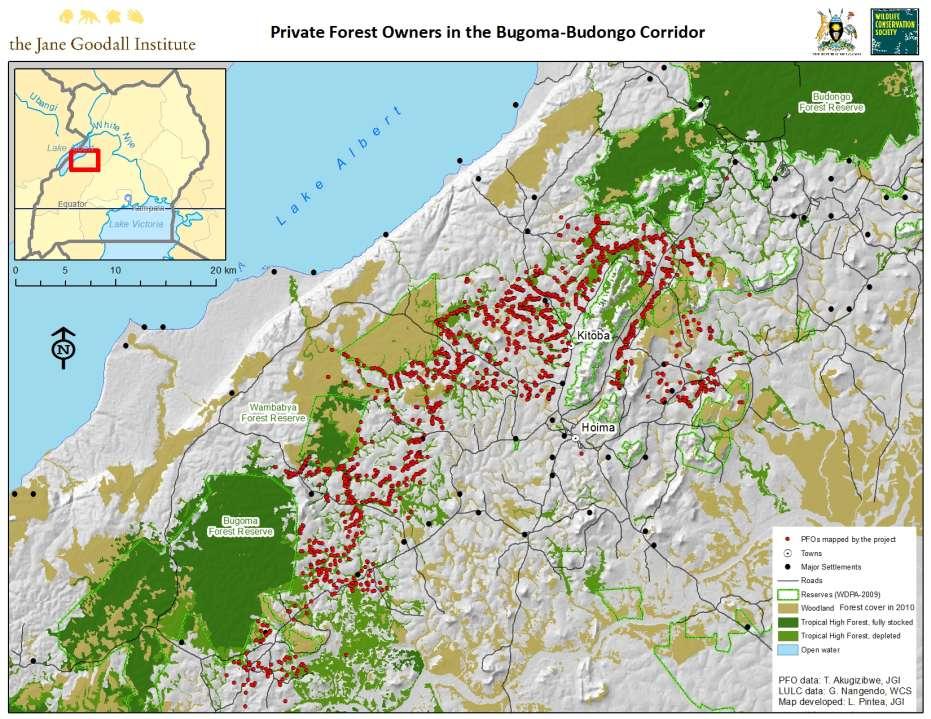
21 Tchimpounga Nature Reserve, Republic of the Congo
22
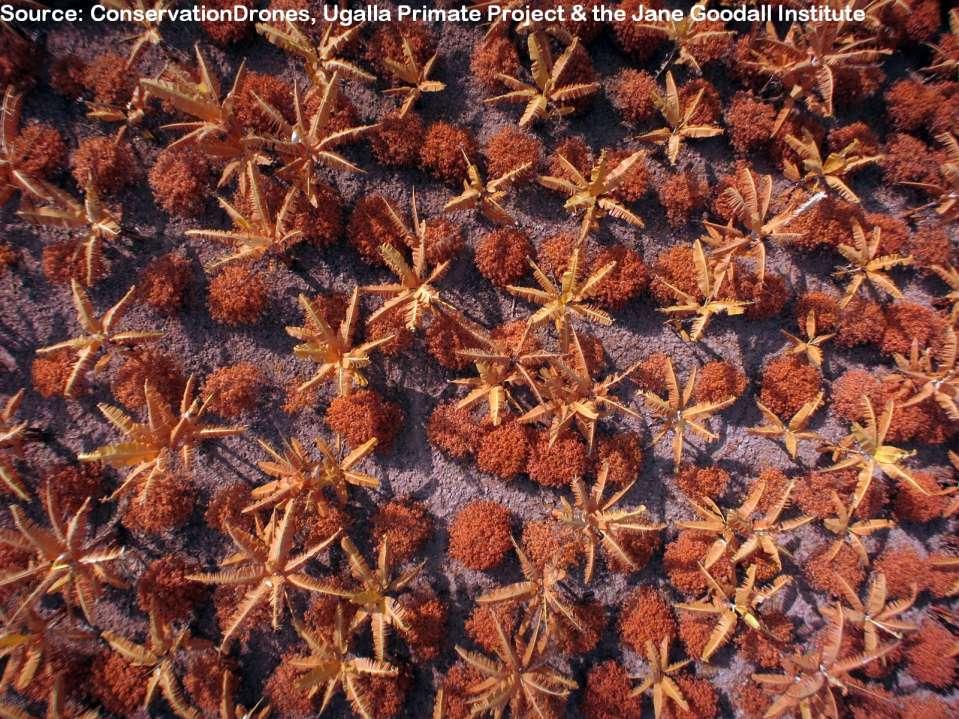
23 Chimpanzee nests from UAV in Tanzania Source: Conservation Drones, Ugalla Primate Project and the Jane Goodall Institute
24 Chimpanzee nests from UAV in Tanzania Source: Conservation Drones, Ugalla Primate Project and the Jane Goodall Institute


25 3. From Monitoring to Action: Forest Watcher Mobile App


26 Forest Watcher mobile app: Enabling local stakeholders with limited and occasional Internet connectivity to receive and groundtruth deforestation alerts from Global Forest Watch.
27

28 Private Forest Owner Associations: collectively manage and negotiate for benefits, REDD+ and other payments for ecosystem services.

29
30 FORMA bi-weekly Deforestation alerts from MODIS satellites (points)
 500 x 500 meter")
31 FORMA bi-weekly deforestation alerts from MODIS satellites (points) 500 x 500 meter pixels
32


33 Imagery QuickBird: January 2012 Deforestation alerts: Field validation: April 2014


34 4. From the ground to the cloud and back to decisions Science & Technology Partners (data analysis, models, tools ) Field data collected by communities and rangers Cloud Dashboards for decision-makers in low bandwidth environments to visualize crowdsourced data from mobile collections


35 Monitoring and Forecasting Chimpanzee Habitat Health in Africa to Inform Conservation Actions, Strategies, and Measure Success Lilian Pintea 1, Samuel Jantz 2, Janet Nackoney 2, Matthew Hansen 2 1 The Jane Goodall Institute, Vienna, VA, USA, 2 Department of Geographical Sciences, University of Maryland, College Park, MD, USA Mapping Chimpanzee Habitat Health Developing a Decision Support System (DSS) Remote sensing and cloud computing enable the use of satellite observations to provide a synoptic view of habitats at fine spatial and temporal resolutions that are locally relevant and consistent across the entire chimpanzee range in Africa. With support from NASA s Applied Sciences Ecological Forecasting Program, JGI and UMD are developing an operational Decision Support System (DSS) to monitor chimpanzee habitat health. The system integrates Earth observations from 30-meter resolution Landsat data with a species-specific habitat model and a model forecasting future land use change, enhanced by crowd-sourced field data collected by local communities and rangers using the Open Data Kit app and Android mobile smartphones and tablets. Input data and the final DSS will be hosted on the Google Cloud. A user-friendly web interface using Google Earth Engine API will be developed for DSS use and maintance.

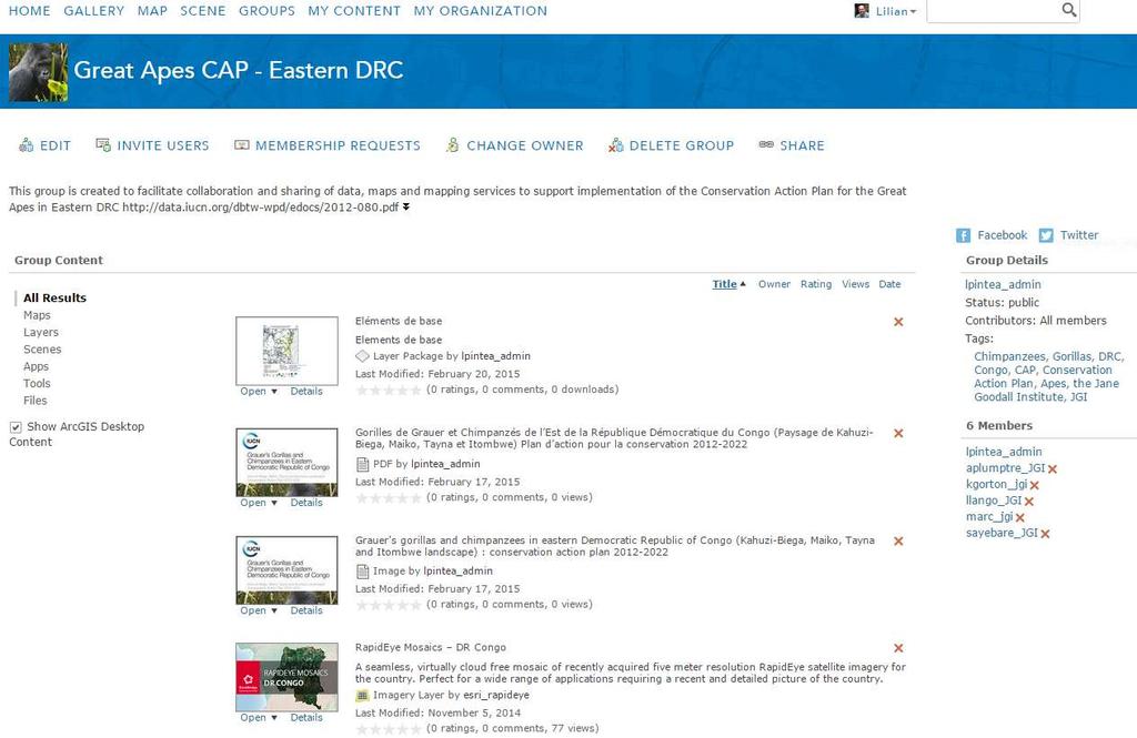
36 5. Enabling collaboration and data sharing

37
38

39


40 THANK YOU! Local communities and Governments of Tanzania, DRC, Uganda and Republic of Congo
Request for Proposal. Improve JGI s Information Technology Infrastructure
 Request for Proposal Improve JGI s Information Technology Infrastructure the Jane Goodall Institute 1595 Spring Hill Road Suite 550 Vienna, VA 22182 703-682-9220 1 Improve JGI s Information Technology
the Jane Goodall Institute New Zealand Board Recruitment Kit
 the Jane Goodall Institute New Zealand Board Recruitment Kit February 2017 CONTENTS OBJECTIVES 4 FUTURE GOALS 5 BOARD MEMBER POSITION DESCRIPTION 8 THE ROLE 8 GENERAL REQUIREMENTS 9 BOARD MEMBER & SUB-COMMITTEE
Good Practice of the Preparation of Information System. Central Africa Case of the Democratic Republic of the Congo
 Japan International Cooperation Agency Ministry of Environment, Nature Conservation and Sustainable Development Directorate of Inventory and Management (DIAF) Good Practice of the Preparation of Information
Role and importance of Satellite data in the implementation of the COMIFAC Convergence Plan
 Plenary Meeting of the Congo Basin Forest Partnership (CBFP) Palais des Congrès, Yaoundé. Cameroon 11-12 November, 2009 Role and importance of Satellite data in the implementation of the COMIFAC Convergence
Fire Information for Resource Management System (FIRMS)
") Fire Information for Resource Management System (FIRMS) Diane Davies 1, Chris Justice 1, Jacques Descloitres 2, John Latham 3 John Musinsky 4 1 Department of Geography, University of Maryland 2 SSAI /
Fire Information for Resource Management System (FIRMS) Diane Davies 1, Chris Justice 1, Jacques Descloitres 2, John Latham 3 John Musinsky 4 1 Department of Geography, University of Maryland 2 SSAI /
International Journal of Asian Social Science
 International Journal of Asian Social Science ISSN(e): 2224-4441/ISSN(p): 2226-5139 journal homepage: http://www.aessweb.com/journals/5007 ANALYSIS OF DRIVERS AND AGENTS OF DEFORESTATION AND FOREST DEGRADATION
Remote Sensing in Support of Multilateral Environmental Agreements
 Remote Sensing in Support of Multilateral Environmental Agreements Alex de Sherbinin CIESIN, The Earth Institute, Columbia University Presented at the Satellites and the Law Enforcement Meeting London,
Ensuring a Future for. Great Apes
 Ensuring a Future for Great Apes Table of Contents Letter from the President 2 About Jane Goodall 3 About Us 4 The State of the African Great Ape 5 Why Save Great Apes? 6 The Human Factor 7 Goal 8 Program
JICA s Cooperation for. Sustainable Forest. Management
 JICA s Cooperation for Sustainable Forest Management 9 March 2016 GOSEKI Kazuhiro Forestry & Nature Conservation Group, Global Environment Department, Japan International Cooperation Agency Outline of
Existing products and tools for country support
 NFMS and MRV FAO Forestry Existing products and tools for country support FAO Forestry www.fao.org/forestry Country Level HQ Level NFMS/MRV cooperation and coordination at HQ and national level P&Ms UN-REDD
Remote sensing in the REDD+ context lessons learned and way forward
 Remote sensing in the REDD+ context lessons learned and way forward Dr. Inge JONCKHEERE UN-REDD Team (FAO HQ Rome, Italy) Forest Monitoring Systems and Reference Levels for REDD+ October 2014 Hanoi, VietNam
State of Alberta Forests: With A Focus on the Eastern Slopes
 State of Alberta Forests: With A Focus on the Eastern Slopes by Peter Lee, Executive Director Global Forest Watch Canada for the Alberta Wilderness Association s 2014-06-26 Fish, Forests, and Flood Resiliency
UAVs 4 STEM. Using recreational drones for learning. March 22, 2016 Presenters: LuAnn Dahlman, NOAA Dan Zalles, SRI
 UAVs 4 STEM Using recreational drones for learning E Federation of Earth Science Information Partners (ESIP) adsf Education Committee March 22, 2016 Presenters: LuAnn Dahlman, NOAA Dan Zalles, SRI Earth
The Forest Changescape: a view from above
 The Forest Changescape: a view from above Daniel J. Hayes ORNL Environmental Science Division SAMSI - Program on Mathematical and Statistical Ecology (ECOL) Workshop Wednesday, 20 August 2014 Research
Mass Notification System
 Mass Notification System 2 2,500+ Local Governments 55,000+ Users Emergency and Routine Communications Made Easy 60+ Million People Impacted CivicPlus was founded over 20 years ago to help local governments
Remote sensing as a tool to detect and quantify vegetation properties in tropical forest-savanna transitions Edward Mitchard (University of Edinburgh)
") Remote sensing as a tool to detect and quantify vegetation properties in tropical forest-savanna transitions Edward Mitchard (University of Edinburgh) Presentation to Geography EUBAP 10 th Oct 2008 Supervisor:
Remote sensing as a tool to detect and quantify vegetation properties in tropical forest-savanna transitions Edward Mitchard (University of Edinburgh) Presentation to Geography EUBAP 10 th Oct 2008 Supervisor:
Linking Remote Sensing and Economics: Evaluating the Effectiveness of Protected Areas in Reducing Tropical Deforestation
 Linking Remote Sensing and Economics: Evaluating the Effectiveness of Protected Areas in Reducing Tropical Deforestation Joe Maher 1 and Xiaopeng Song 2 1 University of Maryland, Department of Agricultural
Map accuracy assessment methodology and results for establishing Uganda s FRL
 Map accuracy assessment methodology and results for establishing Uganda s FRL 1 Table of Contents Acronyms... 4 1 Introduction... 5 2 Process and institutions involved... 5 3 Objectives of the map AA...
BCI Criterion 4.2. Smallholders. Conversion Risk Assessment Procedure. Version 0.1
 BCI Criterion 4.2 Conversion Risk Assessment Procedure Smallholders Version 0.1 Identification Name of producer: Name of Production Unit: Location (administrative unit, province/state and country): Area
Forest Monitoring in Tropical Regions
 Forest Monitoring in Tropical Regions Manuela Hirschmugl & Mathias Schardt Institute of Digital Image Processing, Joanneum Research Content: 1. Background 2. Data 3. Methods 3.1. Pre-processing 3.2. Segmentation
Chapter 21: The Future of the Gombe Chimps
 Chapter 21: The Future of the Gombe Chimps Inspirational leaders and cutting- edge programs are doing all they can to bring chimps, other great apes, and so many other species back from the brink, but
Chubb Travel Smart deployment and user guide. Travel Smart deployment guide and dashboard instructions for HR, Risk and Security Managers
 Chubb Travel Smart deployment and user guide Travel Smart deployment guide and dashboard instructions for HR, Risk and Security Managers Contents Introduction and documentation 3 Registering a Company
CARVING UP THE CONGO
 CARVING UP THE CONGO DESTRUCTION BY NUMBERS LOGGING ROADS TO CLIMATE RUIN UP TO 25% OF GREENHOUSE GAS EMISSIONS COMES FROM TROPICAL FOREST CLEARANCE Up to a quarter of all greenhouse gas emissions are
Towards the Improvement of National Forest Monitoring Approaches
 Towards the Improvement of National Forest Monitoring Approaches Arief Wijaya Center for International Forestry Research (CIFOR), Indonesia Contributors: Ruandha Agung Sugardiman, Budiharto, Anna Tosiani,
RESTORE+: Addressing Landscape Restoration for Degraded Land in Indonesia and Brazil. Picture credit Stora Enso
 RESTORE+: Addressing Landscape Restoration for Degraded Land in Indonesia and Brazil Picture credit Stora Enso IMPORTANCE OF RESTORATION Bonn Challenge and Global Partnership on Forest Landscape Restoration
Dynamic Maps of Open Surface Water Bodies in Oklahoma at 30- m Spatial Resolution during
 Dynamic Maps of Open Surface Water Bodies in Oklahoma at 30- m Spatial Resolution during 1984-2014 Xiangming Xiao Center for Spatial Analysis Earth Observation and Modeling Facility Department of Microbiology
This document is for review purposes only. Do Not Distribute. (c) Esri Press. us department of agriculture
 Esri Press. us department of agriculture") us department of agriculture Putting our data on these maps within our existing systems is a really, really big deal for us. Just clicking on a map is a more intuitive way for us to understand and to explore
us department of agriculture Putting our data on these maps within our existing systems is a really, really big deal for us. Just clicking on a map is a more intuitive way for us to understand and to explore
JOB DESCRIPTION. Real-time monitoring (RTM) Project Coordinator
 Project Coordinator") JOB DESCRIPTION Real-time monitoring (RTM) Project Coordinator Start date: January 2016 Duration of contract: Until 31 st March 2018 Reporting to: Research and Policy Coordinator Close working relationship
JOB DESCRIPTION Real-time monitoring (RTM) Project Coordinator Start date: January 2016 Duration of contract: Until 31 st March 2018 Reporting to: Research and Policy Coordinator Close working relationship
Remote sensing systems to monitor conversion areas
 Supported by Remote sensing systems to monitor conversion areas Lao-EU FLEGT VPA, Crowne Plaza, Seite 1 Supported by Contents 1 Monitoring of Conversion Areas 2 Optical Earth Observation 3 Forest Degradation
Current Status of NFMIS in Myanmar & How MOLI data can Contribute to the ongoing Efforts. Myat Su Mon, Forest Department, Myanmar
 Current Status of NFMIS in Myanmar & How MOLI data can Contribute to the ongoing Efforts Myat Su Mon, Forest Department, Myanmar 26-05-2017 1 Presentation Outlines Background Information Challenges for
MONITORING LAND USE AND LAND USE CHANGES IN FRENCH GUIANA BY OPTICAL REMOTE SENSING
 MONITORING LAND USE AND LAND USE CHANGES IN FRENCH GUIANA BY OPTICAL REMOTE SENSING Photo : Valéry Gond Photo : Valéry Gond Photo Photo : Gaëlle : : Valéry VERGER Gond Gaëlle VERGER ONF, French National
2014REDD302_41_JCM_PM_ver01
 Joint Crediting Mechanism Proposed Methodology Form Cover sheet of the Proposed Methodology Form Form for submitting the proposed methodology Host Country Indonesia Name of the methodology proponents Mitsubishi
Harnessing the power of GIS
 Harnessing the power of GIS Geospatial World Forum May 25, 2016 2 The changing geospatial landscape Historical perspective Copyright 2016 2016 Deloitte Development LLC. LLC. All All rights rights reserved.
LANDSCAPE APPROACH MANAGEMENT. De-coupling Environmental Degradation from Sustainable Growth
 LANDSCAPE APPROACH MANAGEMENT De-coupling Environmental Degradation from Sustainable Growth 1 APP SUSTAINABILITY ROADMAP The Sustainability Roadmap Vision 2020, launched in 2012, is our strategy to place
Global Challenges - Lecture Biodiversity. Felix Eigenbrod, Biological Sciences
 Global Challenges - Lecture Biodiversity Felix Eigenbrod, Biological Sciences f.eigenbrod@soton.ac.uk Outline of today s lecture What is biodiversity? What are the big patterns of biodiversity? Why is
GEOGLAM international cooperation activities
 GEOGLAM international cooperation activities Chris Justice Center for Global Agricultural Monitoring and Research Dept. of Geographical Sciences University of Maryland GEO: an International Coordinating
SOUTHERN INDIANA 2008 FLOODS: DAMAGE ASSESSMENT AND WEB MAPPING
 SOUTHERN INDIANA 2008 FLOODS: DAMAGE ASSESSMENT AND WEB MAPPING Ejaz Hussain KyoHyouk kkim Jie Shan, Associate Professor {ehussain,kim458,jshan}@,j purdue.edu Tel:765-494-2168 School Of Civil Engineering
Using data technology to scale impact
 Using data technology to scale impact At SNV we are committed to achieving impact at scale and information technology plays a crucial role in this endeavour. The increasing availability and affordability
Monitoring Natural Sal Forest Cover in Modhupur, Bangladesh using Temporal Landsat Imagery during
 Monitoring Natural Sal Forest Cover in Modhupur, Bangladesh using Temporal Landsat Imagery during 1972 2015 Hasan Muhammad Abdullah *, M. Golam Mahboob, Md.Mezanur Rahman, Tofayel Ahmed * Assistant Professor,
Forest and Land Cover Monitoring by Remote Sensing Data Analysis
 Low Carbon Asia Research Network (LoCARNet) 3rd Annual Meeting Bogor, Indonesia November 24 26, 2014 Forest and Land Cover Monitoring by Remote Sensing Data Analysis Muhammad Ardiansyah Center for Climate
A REVIEW OF FOREST FIRE INFORMATION TECHNOLOGIES IN VIETNAM
 A REVIEW OF FOREST FIRE INFORMATION TECHNOLOGIES IN VIETNAM Le Thanh Ha 1, Nguyen Hai Chau 1, Nguyen Hoang Nam 1, Bui Quang Hung 1, Nguyen Thi Nhat Thanh 1, Nguyen Ba Tung 1, Do Khac Phong 1, Nguyen Van
Summary of the socio-economic impact of Copernicus in the EU
 Summary of the socio-economic impact of Copernicus in the EU ESA Since the entry into service of Copernicus first satellite, Sentinel-1A, in 2014, the impacts of the programme are witnessed beyond the
2. Relevant operational framework(s)
") Inputs provided by: International Center of Insect Physiology and Ecology (ICIPE), Nairobi, Kenya 1. General description of mandates and objective(s) of your organization / associated network with institutional
Inputs provided by: International Center of Insect Physiology and Ecology (ICIPE), Nairobi, Kenya 1. General description of mandates and objective(s) of your organization / associated network with institutional
Amazon Research and Conservation Center
 Amazon Research and Conservation Center a place-based conservation laboratory for research, community learning, and sustainable business innovation Photo: Tom Ambrose ARCC Overview Context of ARCC Key
Overview of Capacity Building Activities in Eastern, Southern and Central Africa Leo Niskanen & Geoffroy Mauvais IUCN
 Overview of Capacity Building Activities in Eastern, Southern and Central Africa Leo Niskanen & Geoffroy Mauvais IUCN INTERNATIONAL UNION FOR CONSERVATION OF NATURE Outline 1. Overview of the region- Leo
The Future is Now: Gill Dickson, 26 May 2015
 The Future is Now: Accessing and Managing Geospatial Data in 2015 is Easier Than Ever Gill Dickson, 26 May 2015 Data Management Solutions The cure for geospatial data management headaches Solutions that
CRM Comparison White Paper:
 CRM Comparison White Paper: Salesforce, Zoho CRM, SugarCRM, Pipedrive & Odoo April 2016 Introduction Introducing CRM offers available today Today s CRM market offers a significant number of solutions and
Mercedes-Benz Concierge Service
 Mercedes-Benz CONNECT :: Convenience Service Mercedes-Benz Concierge Service High-quality personal assistance at the touch of a button. Access to high-quality, personal VIP service at any time of the day
To provide timely, accurate, and useful statistics in service to U.S. agriculture
 NASS MISSION: To provide timely, accurate, and useful statistics in service to U.S. agriculture What does NASS do? Administer USDA s Statistical Estimating Program Conduct the 5-year Census of Agriculture
from forest carbon optimizing conservation benefits Glenn Prickett, Senior Vice President, Conservation International
 optimizing conservation benefits from forest carbon Glenn Prickett, Senior Vice President, Conservation International Presented at the World Conservation Congress: Delivering Multiple Benefits from Forest
Strategic Plan of Action
 Heart of Borneo Strategic Plan of Action Bridging Conservation and Sustainable Development in Three Countries Strategic Plan of Actions The Heart of Borneo Initiative Introduction The Heart of Borneo
UNEP N eeds Needs for for LULC data and information
 UNEP Needs for LULC data and information By Ashbindu Singh Chief, Early Warning Branch UNEP Division of Early Warning& Assessment and Regional Coordinator UNEP Division of Early Warning & Assessment- North
DRIVING SOCIAL IMPACT WITH TECHNOLOGY AND DATA
 DRIVING SOCIAL IMPACT WITH TECHNOLOGY AND DATA About Data Science, Surveys and Enabling Technologies HARNESSING THE POWER OF TECHNOLOGY AND DATA TO DRIVE SOCIAL IMPACT Abt Associates is an industry pioneer
A global perspective on land use and cover change
 A global perspective on land use and cover change Alan Belward The Global Environment Monitoring Unit Institute for Environment and Sustainability European Commission Joint Research Centre 21027 Ispra
Stocktaking Overview of the G20. Global Agricultural Monitoring Initiative
 Stocktaking Overview of the G20 Global Agricultural Monitoring Initiative February 2018 Background The Group on Earth Observations Global Agricultural Monitoring Initiative (GEOGLAM) was initially launched
KEEPING AN EYE ON SDG 15. Working with countries to measure indicators for forests and mountains
 KEEPING AN EYE ON SDG 15 Working with countries to measure indicators for forests and mountains FORESTS AND MOUNTAINS IN THE SUSTAINABLE DEVELOPMENT GOALS The 2030 Agenda for Sustainable Development and
REDD+ project in Luang Prabang Province through controlling slash-and-burn
 JCM REDD+ Model Projects by Ministry of the Environment, Japan REDD+ project in Luang Prabang Province through controlling slash-and-burn Japan Forest Technology Association 1. General information on the
Secure Your Way of Life. Climax Home Portal Platform. Envisage and Enable a Connected Future
 Secure Your Way of Life Climax Home Portal Platform Envisage and Enable a Connected Future Climax Home Portal Platform An IP/GPRS-Based Solution to Deliver Smart Home and Mobile Control Services Reliable
ROLES OF FOREST AND FORESTRY IN INDONESIA
 ROLES OF FOREST AND FORESTRY IN INDONESIA Mega biological diversity and one of the custodians of global peat land, Source of income and other customary uses for people live in and surrounding forests.
Mapping the world s forests: work by FAO and partners in the global Forest Resource Assessment (FRA) Mette L. Wilkie Adam Gerrand FAO
 Mette L. Wilkie Adam Gerrand FAO") Mapping the world s forests: work by FAO and partners in the global Forest Resource Assessment (FRA) Mette L. Wilkie Adam Gerrand FAO www.fao.org/forestry/fra2010 Main points Challenges unprecedented global
Mapping the world s forests: work by FAO and partners in the global Forest Resource Assessment (FRA) Mette L. Wilkie Adam Gerrand FAO www.fao.org/forestry/fra2010 Main points Challenges unprecedented global
Bioenergy & Sustainability a SCOPE series volume Launching the report of a global assesment of bioenergy sustainability
 Environmental Security and Ecosystem Services: biodiversity, restoring soils and protecting ecosystems in bioenergy landscapes, harmonizing forestry and agriculture policies Mateus Batistella Embrapa Satellite
Conditions for Project Success: Economic and Social Feasibility of PES. Michael Richards
 Conditions for Project Success: Economic and Social Feasibility of PES Michael Richards Training Workshop on Payments for Ecosystem Services (PES) and Reducing Emissions from Deforestation and Forest Degradation
FORMA: Forest Monitoring for Action
 FORMA: Forest Monitoring for Action FORMA uses freely-available satellite data to generate rapidly-updated online maps of tropical forest clearing. We have designed it to provide useful information for
Climate Change. Confronting a global challenge
 Climate Change Confronting a global challenge Answering a global warning We have entered an era of dangerous climate disruption and it poses a fundamental threat to the vulnerable places, species and people
What is Castleton Agile?
 Agile Datasheet About us Castleton is the only truly integrated IT housing solutions provider in the industry. We deliver an unrivalled portfolio of market leading, cutting edge software and infrastructure
A look past and a look forward. David Skole Michigan State University
 A look past and a look forward David Skole Michigan State University Antecedents ca. 1988-94 There were important antecedents to the NASA LCLUC program Two important drivers: Large scale Landsat databases
The Leading Low-code Application Platform For Modern Work Management
 The Leading Low-code Application Platform For Modern Work Management TrackVia is a next-generation low-code application platform designed to help business and operations executives gain newfound control
Forest Carbon Accounting for REDD+ Readiness at District and FMU Level Experiences from Kalimantan
 Indonesian-German Forests and Climate Change Programme (FORCLIME) Forest Carbon Accounting for REDD+ Readiness at District and FMU Level Experiences from Kalimantan Jakarta, 03.03.2015 Franz-Fabian Bellot
NASA s Contribution to Water Research, Applications, and Capacity Building in Africa
 NASA s Contribution to Water Research, Applications, and Capacity Building in Africa Nancy D. Searby 1, David Toll 2, Rick Lawford 3, 1 NASA HQ Earth Sciences Division Applied Sciences Program 2 NASA GSFC
THE WORLD FOREST OBSERVATORY An Instrument for Global Forest Measurement. Alan Grainger. University of Leeds
 THE WORLD FOREST OBSERVATORY An Instrument for Global Forest Measurement Alan Grainger University of Leeds If astronomers can continually observe the universe... Why can't global change scientists continually
Zambia s National Forest Monitoring System
 Zambia s National Forest Monitoring System Deuteronomy Kasaro 1 and Julian Fox 2 1. REDD+ National REDD+ Coordinator deutkas@yahoo.co.uk 2. UN-REDD MRV facilitator Julian.fox@fao.org ZAMBIA Programme Goal:
Fragmentation of tropical forests a forgotten process in the global carbon cycle?
 Fragmentation of tropical forests a forgotten process in the global carbon cycle? A. Huth 1,2, K. Brinck 1,3, R. Fischer 1, J. Groeneveld 1, S. Puetz 1 1 Helmholtz Centre for Environmental Research, Leipzig,
GPS & Drone Workshops
 GPS & Drone Workshops Rutgers University Inn, New Brunswick December 11-12, 2017 Presented by Discovery Management Group, LLC Co-sponsored by the Center for Remote Sensing & Spatial Analysis, Rutgers University
EU-Africa collaboration on Space applications for Africa
 EU-Africa collaboration on Space applications for Africa Background Maputo Declaration: African policy makers request EC to open its GMES initiative to Africa (Oct 2006) Build on existing EO activities
Section Objectives: Explain biodiversity and its importance. Relate various threats to the loss of biodiversity.
 Section Objectives: Explain biodiversity and its importance. Relate various threats to the loss of biodiversity. Biological Diversity Biodiversity refers to the variety of species in a specific area. The
The South/Southeast Asia Research Initiative (SARI) Update and Meeting Objectives. Krishna Prasad Vadrevu NASA Marshall Space Flight Center
 Update and Meeting Objectives. Krishna Prasad Vadrevu NASA Marshall Space Flight Center") The South/Southeast Asia Research Initiative (SARI) Update and Meeting Objectives Krishna Prasad Vadrevu NASA Marshall Space Flight Center Presentation topics Background to the SARI initiative Meeting
The South/Southeast Asia Research Initiative (SARI) Update and Meeting Objectives Krishna Prasad Vadrevu NASA Marshall Space Flight Center Presentation topics Background to the SARI initiative Meeting
Internet of Things. Point of View. Turn your data into accessible, actionable insights for maximum business value.
 Point of View Internet of Things Turn your data into accessible, actionable insights for maximum business value Executive Summary Use a connected ecosystem to create new levels of business value The Internet
Curbing deforestation in the Congo Basin with the polluter pays. principle, the provider gets principle and the REDD+
 Curbing deforestation in the Congo Basin with the polluter pays principle, the provider gets principle and the REDD+ mechanism PhD Candidate Blaise-Pascal Ntirumenyerwa Mihigo Public International Law
LESTARI Fast Facts on its biodiversity conservation work
 LESTARI Fast Facts on its biodiversity conservation work The LESTARI approach Indonesia s 17,493 tropical islands contain some of the highest levels of biological diversity across the globe, making it
MEETS MOBILE MAINFRAME. Access information anytime, anywhere
 MAINFRAME MEETS MOBILE Access your Adabas & Natural and mainframe applications from anywhere TABLE OF CONTENTS 1 Introduction 1 Access information anytime, anywhere 2 Secure integration with mainframe
Building Customer Intimacy with Cisco Omnichannel Contact Center Solutions
 Building Customer Intimacy with Cisco Omnichannel Contact Center Solutions Mathew Varghese Chief Technology Officer Contact Center Asia Pacific-Japan & China 29 th April 2014 Omnichannel Defined Omnichannel
Moving away from shifting cultivation?
 UNIKIS Moving away from shifting cultivation? Implications for sustainable development in Tshopo District, DR Congo Pieter Moonen Bart Muys Bruno Verbist Content The context: sustainable rural development
Service ASSISTANT. Foundation to any successful service-based business. It is accessible from your home, vehicle or office with seamless 24/7 access.
 Ask us how to receive a free demo of the all new Service Assistant 5. Service ASSISTANT Foundation to any successful service-based business. It is accessible from your home, vehicle or office with seamless
AIMS pilot project. Monitoring the rehabilitation of degraded landscapes from Food Assistance for Assets programmes with satellite imagery
 Fighting Hunger Worldwide AIMS pilot project Monitoring the rehabilitation of degraded landscapes from Food Assistance for Assets programmes with satellite imagery September 2017 BEFORE road construction
Solution Components Sugar 6.5 Release
 Solution Components 6.5 Release CRM, Inc. 10050 N. Wolfe Road SW2-130 Cupertino, CA 95014 USA T: +1.408.454.6900 F: +1.408.873.2872 CRM Solution Components This is a list of the most common components
Our vision is to leverage power of maps, location, big data and analytics to change our cities.
 COMPANY PROFILE Introduction Transerve aims to bring digital transformation through geospatial technology. We at Transerve develop solutions for managing city operations like taxation, water, sanitation,
Mainstreaming Biodiversity into national, local and sectoral policies and programmes
 Mainstreaming Biodiversity into national, local and sectoral policies and programmes Indonesia By Vidya Sari Nalang Ministry of Environment Montreal, 13-15 May 2009 INDONESIA (megabiodiversity) Terrestrial
5-2 Limits to Growth Slide 1 of 21
 1 of 21 Limiting Factors Limiting Factors The primary productivity of an ecosystem can be reduced when there is an insufficient supply of a particular nutrient. Ecologists call such substances limiting
REQUEST FOR PROPOSALS
 Announcement REQUEST FOR PROPOSALS ESRI GIS Implementation Services The Madison Metropolitan Sewerage District (MMSD or district ) seeks proposals from qualified vendors to implement Esri s geographic
Top 10 Reasons Why Enterprises Should Adopt a Cloud-based Approach for Mobile Application Testing
 2011 Top 10 Reasons Why Enterprises Should Adopt a Cloud-based Approach for Mobile Application Testing EXTREMELY DYNAMIC MOBILE MARKET DICTATES A NEW TESTING APPROACH As an increasing number of organizations
CIEEM Autumn Conference Workshop
 CIEEM Autumn Conference Workshop Getting to grips with the use of Small Unmanned Aerial Vehicles (SUAVs) in Ecological Practice Nottingham 2016 Cameron S Crook MCIEEM Cameron S Crook & Associates Introduction
Chandrashekhar Biradar, PhD Principal Scientist (Agro-Ecosystems) Head-Geoinformatics Unit 30 March 2017 Bangkok, Thailand
 Head-Geoinformatics Unit 30 March 2017 Bangkok, Thailand") Chandrashekhar Biradar, PhD Principal Scientist (Agro-Ecosystems) Head-Geoinformatics Unit c.biradar@cgiar.org 30 March 2017 Bangkok, Thailand People Drylands increased Ensuring Food Security Gender Address
Chandrashekhar Biradar, PhD Principal Scientist (Agro-Ecosystems) Head-Geoinformatics Unit c.biradar@cgiar.org 30 March 2017 Bangkok, Thailand People Drylands increased Ensuring Food Security Gender Address
BASELINES, PERMANENCE AND LEAKAGE IN REDD
 BASELINES, PERMANENCE AND LEAKAGE IN REDD Willy R. Makundi Consultant / Scientist Environmental Management Consultants Moshi, Tanzania / Environmental Energy Technologies Division, Lawrence Berkeley National
Chair s conclusions. The Chair summarised the discussions as follows and will forward his conclusions to the summit chair.
 Potsdam, 15-17 March 2007 Chair s conclusions The Environment Ministers of the G8 countries as well as of Brazil, China, India, Mexico and South Africa, the European Commissioner responsible for the environment
GLOBAL PALM OIL SOURCING UPDATE KEY FACTS. SIGNIFICANT PROGRESS: 87% global traceability to the mill at the end of 2016 MARCH 2017
 GLOBAL PALM OIL SOURCING UPDATE KEY FACTS MARCH 2017 SIGNIFICANT PROGRESS: 87% global traceability to the mill at the end of CLOSING THE TRACEABILITY GAP: Continuing collaborative efforts to improve traceability
Combating illegal logging
 Combating illegal logging Lessons from the EU FLEGT Action Plan A summary In this summary of the publication Lessons from the EU FLEGT Action Plan, we look at the Action Plan s impact in the 10 years since
By Gerald Urquhart, Walter Chomentowski, David Skole, and Chris Barber
 By Gerald Urquhart, Walter Chomentowski, David Skole, and Chris Barber The clearing of tropical forests across the Earth has been occurring on a large scale basis for many centuries. This process, known
Carbon Cycle & Ecosystems. Diane E. Wickland, Focus Area Lead April 12, 2006
 Carbon Cycle & Ecosystems Diane E. Wickland, Focus Area Lead April 12, 2006 Carbon Cycle & Ecosystems Program Elements & Managers Ocean Biology and Biogeochemistry Paula Bontempi Land Cover and Land Use
REMOTE TANK MONITORING SYSTEM FOR BUSINESS & INDUSTRY
 REMOTE TANK MONITORING SYSTEM FOR BUSINESS & INDUSTRY BY KINGSPAN ENVIRONMENTAL SEE WHAT S HAPPENING IN EVERY TANK ACROSS YOUR ENTIRE BUSINESS. Watchman Anywhere Pro can continually monitor every tank
Impact of SCP on global trade of soft-commodities
 Impact of SCP on global trade of soft-commodities 24 th October 2017 Shiro Chikamatsu Ecological Economic Solutions Sdn. Bhd. (1005160-P) Objectives Understand the impact of global trade on sustainability