Remote Sensing of Water Resources
|
|
|
- Herbert Carr
- 5 years ago
- Views:
Transcription
1 Remote Sensing of Water Resources National Disaster Management Institute Yoomi Hur


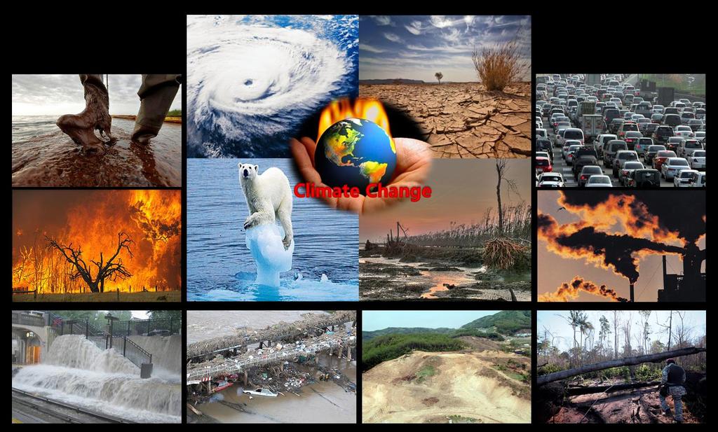
2 Climate Change Hydrologic Cycle Hydrologic Indices Soil Moisture Evaportranspiration Drought Conclusions
3 3

4 The water cycle is the only way that Earth can be continually supplied with fresh water. The heat from the sun is the most important part of renewing our water supply. 4


5 Soil Moisture Evapotranspiration Drought MODIS-Based ESI Estimation AMSR-E Soil Moisture / August, : :25 Instantaneous Radiation Dry Wet ESI / Spring ESI / Summer : :55 Instantaneous Evapotranspiration (ET) Dry Wet ESI / Autumn ESI / Winter SMOS Retrieval Algorithm
6

7 Hydrologic Cycle Soil Moisture Source :

8 Satellite based measurements of soil moisture B Brand New Satellite!!! Accurate observation!!!


9 VUA, AMSR-E Soil Moisture on January, 2007 VUA, AMSR-E Soil Moisture on August,

10 Downscaling application 10
11 Paper : Choi*, M., and Y. Hur (2012). Remote Sensing of Environment, doi : /j.rse

 passive remote sensing Measure volumetric")
 SMOS Mission")
12 European Space Agency (ESA) s Earth explorer mission Lunched on November the 2 nd 2009 Using L-band (1.4Ghz) passive remote sensing Measure volumetric soil moisture 4% error ranges Average spatial resolution 43 km (Grid scale 15 km) SMOS Mission

13 Level 0 Level 1 Level 2 Level 3
 Very few data in Korea.")
14 SMOS L2 Product (Soil Moisture) 2011/02/ /03/01 Computed using Brightness Temperature L-band is corrupted measurements by RFI. (Mickaël etal., 2011) Very few data in Korea. 2011/04/ /05/01


15 SMOS L3 Product Very few data in Korea either. Level 3 product soil moisture (January, 2011.)


16 SMOS L1C Product (BrightnessTemperature(TB)) 2011/02/ /03/01 Level 1c data product contains the brightness temperature. Necessary input to Level 2 Processing. 2011/04/ /05/01

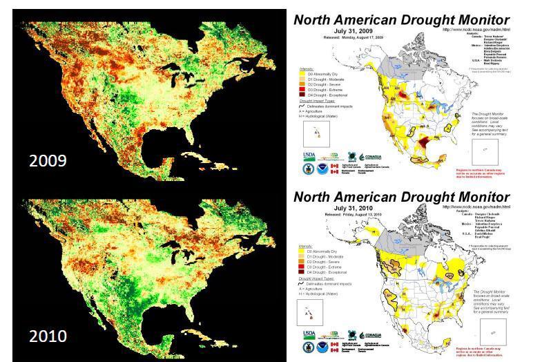
17 SMOS Retrieval Algorithm Backward model Calculate brightness temperature(tb) from estimated soil moisture Match SMOS observed TB and calculated TB Iterate calculation with reestimated SM until difference between observed TB and calculated TB less then error range
 SMOS Observed Soil Moisture SMOS Retrieved Soil")

18 SMOS Observed Brightness Temperature (August 15,2011) SMOS Calculated Brightness Temperature (August 15,2011) SMOS Observed Soil Moisture SMOS Retrieved Soil Moisture (August 15,2011) (August 15,2011) Patent : Soil moisture retrieval algorithm based on the genetic algorithm using satellite data, application number :
19


20 KoFlux Haenam site, Korea < KoFlux Sites, > Evapotranspiration is the water lost to the atmosphere by two processesevaporation and transpiration Apart from precipitation, the most significant component of the hydrologic budget is evapotranspiration Evapotranspiration varies regionally and seasonally; during a drought it varies according to weather and wind conditions 20

21 MODerate resolution Imaging Spectroradiometer (MODIS) multispectral Sensor Onboard Terra (1999) and Aqua (2002) satellites 36 spectral bands in a range of 0.4 to 14.5μm Basic resolution Temporal resolution : 1 day Spatial resolution : 1km X 1km Terra Post processed land/atmospheric products provided by NASA/USGS : high usability 21
22 MODIS 16 Global ET Product Revised and proposed by Mu et al. (2007) based on Cleugh et al. s (2007) Remote Sensing-Penman Monteith (RS-PM) method The land surface ET product represents all transpiration by vegetation and evaporation from canopy and soil surfaces. Spatial distribution of ET is computed globally everyday at 1 km 1 km resolution. 22
23 Penman-Monteith Equation E sa C p ( e sat s (1 r s e) / / r a ) r a λe : latent heat flux (W m -2 ) s : slope of the curve relating saturated water vapor pressure (e sat (Pa)) to temperature (K) (Pa K -1 ) A : available energy (W m -2 ), ρ : air density (kg m -3 ) C p : specific heat capacity of air (J kg -1 K -1 ) e : actual water vapor pressure (Pa), r a : aerodynamic resistance (s m -1 ) γ : the psychrometric constant (Pa K -1 ), r a : aerodynamic resistance (s m -1 ) r s : surface resistance (s m -1 ) Revised RS-PM algorithm - Difficulties of accurate estimation : surface/aerodynamic resistance Using Enhanced Vegetation Index (EVI) to estimate fractional vegetation cover F C EVI EVI max EVI EVI min min F C : fractional vegetation cover EVI : Enhanced Vegetation Index 23
24 Estimation of MODIS-based Evapotranspiration (ET) R net ( 1 ) R sdn R ldn R lup Vegetation Index (LAI, NDVI, ) albedo Air temp. LST Emissivity Solar irradiance MOD13, 15 MOD43 MOD07 MOD11 MOD07 Evapotranspiration!!! 24

25 Spatio-Temporal variation of Evapotranspiration in North-East Asia (monthly) 25
26

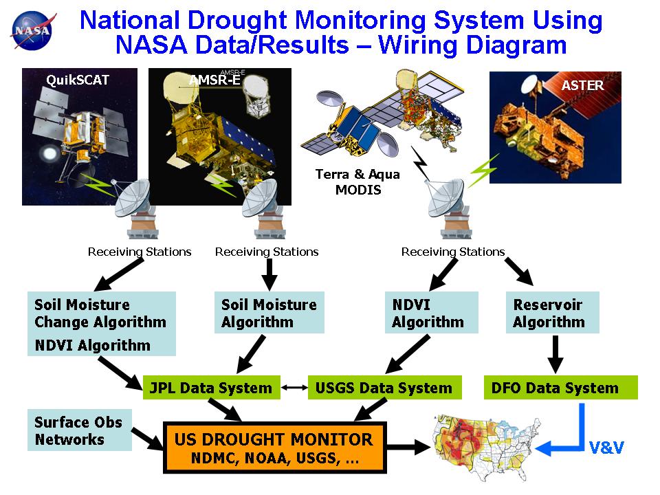
27 Top worst-disaster in the 20 th century (NOAA, 1999) 1. Drought and famine in China in 1907, toll estimated at 24 million. Millions dead in other drought-related famines in , 1936 and Drought in the Ukraine and Volga region of the Soviet Union in , deaths estimated at 250,000 to 5 Four events in Top 5 were caused by drought! million. 3. Indian drought of , estimates of dead at 1.5 million. In 1900, drought in India blamed for 250,000 to 3 million deaths. 4. Yangtze River flood, China, 1931, 3.7 million killed due to flooding and subsequent disease and starvation. 5. Sahel drought in Africa in , with estimates of dead at 600,000; more than that were died in Bangladesh cyclone in 1970, with 300,000 to 500,000 dead in wind and storm surge. 7. Bangladesh cyclone in 1991, with 138,000 killed. 8. Flooding in Vietnam in 1971, with 100,000 killed. 9. Hurricane Mitch in Central America in 1998, with an estimated 11,000 dead, the region's greatest hurricane loss since Great Iran flood in 1954, with more than 10,000 dead. 11. Typhoon Thelma in 1991 in the Philippines, with 6,000 fatalities. 12. Typhoon Vera in Japan in 1958, with 5,000 dead. 13. Great Smog of London in 1952, 4,000 deaths linked to the smog, that many others to related causes. 14. Iran blizzard of 1972, with about 4,000 people dead. 15. Violent winter storms along the coasts of northern Europe, including the Netherlands and United Kingdom, in 1965, with 2,000 lives lost. 27


28 Drought: w.r.t. durations of drought? 1-, 3-months duration: relatively short durations : When rainfall is not sufficient for a short duration, the soil moisture may be reduced, streams of small catchments corresponding to 2 nd or higher order may dry up, and small agricultural reservoirs begin to show its bottom. These may influence on the agricultural activities. (Agricultural drought) 6-, 12-months duration: relatively long durations : If drought continues for a long time, The water level at the large scale dam may keep dropping. And finally, these may influence on the hydrological cycle, water supply system for tab water and industrial water. (Hydrological drought) 28
 : Precipitation data ESI (Evaporative Stress Index; Martha 2007) : Evapotranspiration, Land Surface Temperature SWSI (Surface Water Supply Index; Shafer and Dezman 1982) : Precipitation,")
29 Drought: drought Indices PDSI (Palmer Drought Severity Index ; Palmer 1965) : Precipitation, Temperature, Soil Moisture SPI (Standardized Precipitation Index; McKee et al. 1993, 1995) : Precipitation data ESI (Evaporative Stress Index; Martha 2007) : Evapotranspiration, Land Surface Temperature SWSI (Surface Water Supply Index; Shafer and Dezman 1982) : Precipitation, Steam flow, Ground water stage SMI (Soil Moisture Index), EDI(Effective Drought Index), RDI (Reclamation Drought Index), CMI(Crop moisture Index). 29
30 - temporal anomalies in evapotranspiration (ET) - anomalously high or low rates of water use across the land surface ET - retrieved via energy balance using remotely sensed land-surface temperature (LST) time-change signals. LST - a fast response variable, providing proxy information regarding rapidly evolving surface soil moisture and crop stress conditions at relatively high spatial resolution. The ESI also demonstrates capability for capturing early signals of flash drought, brought on by extended periods of hot, dry and windy conditions leading to rapid soil moisture depletion. 30

31 The history of remote sensing based drought index 31
32 ESI - not require precipitation data The current surface moisture state - deduced directly from the remotely sensed LST More robust in regions with in-situ precipitation monitoring. Signatures of vegetation stress - manifested in the LST signal before any deterioration of vegetation cover occurs Indicated in NDVI, TIR-based indices such as ESI can provide an effective early warning signal of impending agricultural drought 32
33 ALEXI-based ESI - includes non-precipitation related moisture signals (such as irrigation; vegetation rooted to groundwater; lateral flows) ALEXI-based ESI - provides an independent assessment of current drought conditions, supplementing precipitation and modeling-based indices Anderson et al., (2007) 33
34 34
35 35


36 Dry Wet 36
37 Drought 37


38 National Drought Monitoring System using Satellites Data 38
.")
.")
39 Remote sensing is the observation and establishment of a permanent record of an object without actually touching (Paul, 1980). Satellite based sensors offer the advantages of large area mapping and long term repetitive coverage (Jackson et al, 1996). Remote sensing provides a means of observing hydrological state variables temporally and over large areas (Schmugge et al, 2002). Continuous monitoring with remote sensing 39
40
Evaluation of Indices for an Agricultural Drought Monitoring System in Arid and Semi-Arid Regions
 Evaluation of Indices for an Agricultural Drought Monitoring System in Arid and Semi-Arid Regions Alireza Shahabfar, Josef Eitzinger Institute of Meteorology, University of Natural Resources and Life Sciences
Hydrological Applications of LST Derived from AVHRR
 Hydrological Applications of LST Derived from AVHRR By Balaji Narasimhan Research Assistant Department of Agricultural Engineering Texas A&M University Outline Introduction All about LST Model Development
Mapping Water Use and Drought with Satellite Remote Sensing
 Xiwu Zhan NOAA-NESDIS-STAR Jason Otkin University of Wisconsin Mapping Water Use and Drought with Satellite Remote Sensing Christopher Hain NASA-MSFC Li Fang, Mitch Schull Earth System Science Interdisciplinary
Agricultural drought index and monitoring on national scale. LU Houquan National Meteorological Center, CMA
 Agricultural drought index and monitoring on national scale LU Houquan National Meteorological Center, CMA Contents Agricultural drought disasters in China Agricultural drought indices --Precipitation
CROP STATE MONITORING USING SATELLITE REMOTE SENSING IN ROMANIA
 CROP STATE MONITORING USING SATELLITE REMOTE SENSING IN ROMANIA Dr. Gheorghe Stancalie National Meteorological Administration Bucharest, Romania Content Introduction Earth Observation (EO) data Drought
Water balance in soil
 Technische Universität München Water balance Water balance in soil Arno Rein Infiltration = + precipitation P evapotranspiration ET surface runoff Summer course Modeling of Plant Uptake, DTU Wednesday,
Issues include coverage gaps, delays, measurement continuity and consistency, data format and QC, political restrictions
 Satellite-based Estimates of Groundwater Depletion, Ph.D. Chief, Hydrological Sciences Laboratory NASA Goddard Space Flight Center Greenbelt, MD Groundwater Monitoring Inadequacy of Surface Observations
August 6, Min-Ji Park, Hyung-Jin Shin, Jong-Yoon Park Graduate Student. Geun-Ae Park. Seong-Joon Kim
 Comparison of Watershed Streamflow by Using the Projected MIROC3.2hires GCM Data and the Observed Weather Data for the Period of 2000-2009 under SWAT Simulation August 6, 2010 Min-Ji Park, Hyung-Jin Shin,
Expert Meeting on Crop Monitoring for Improved Food Security, 17 February 2014, Vientiane, Lao PDR. By: Scientific Context
 Satellite Based Crop Monitoring & Estimation System for Food Security Application in Bangladesh Expert Meeting on Crop Monitoring for Improved Food Security, 17 February 2014, Vientiane, Lao PDR By: Bangladesh
Remotely-Sensed Fire Danger Rating System to Support Forest/Land Fire Management in Indonesia
 Remotely-Sensed Fire Danger Rating System to Support Forest/Land Fire Management in Indonesia Orbita Roswintiarti Indonesian National Institute of Aeronautics and Space (LAPAN) SE Asia Regional Research
POTENTIALS FOR DETECTING CANOPY WATER STRESS USING GEOSTATIONARY MSG-SEVIRI SWIR DATA
 POTENTIALS FOR DETECTING CANOPY WATER STRESS USING GEOSTATIONARY MSG-SEVIRI SWIR DATA Rasmus Fensholt, *Department of Geography and Geology, University of Copenhagen, Denmark Co-workers; Silvia Huber*,
LAND AND WATER - EARTH OBSERVATION INFORMATICS FSP
 Earth Observation for Water Resources Management Arnold Dekker,Juan P Guerschman, Randall Donohue, Tom Van Niel, Luigi Renzullo,, Tim Malthus, Tim McVicar and Albert Van Dijk LAND AND WATER - EARTH OBSERVATION
Root zone soil moisture and drought indices
 Root zone soil moisture and drought indices Yann H. Kerr, Ahmad AlBitar Jean Pierre Wigneron, Thierry Pellarin and the SMOS team CESBIO, INRA-ISPA, TVU, ECMWF, WSL, LTHE, SMOS Mission Launched in 2009
Research and Applications using Realtime Direct Broadcast Imagery, Weather Radar, and LiDAR in Disaster Response and Preparedness
 Research and Applications using Realtime Direct Broadcast Imagery, Weather Radar, and LiDAR in Disaster Response and Preparedness Richard P. Watson, Ph.D. University of New Mexico Earth Data Analysis Center
Remote sensing: A suitable technology for crop insurance?
 Remote sensing: A suitable technology for crop insurance? Geospatial World Forum 2014 May 9, 2014, Geneva, Switzerland Agenda 1. Challenges using RS technology in crop insurance 2. Initial situation Dominance
Recent increased frequency of drought events in Poyang Lake Basin, China: climate change or anthropogenic effects?
 Hydro-climatology: Variability and Change (Proceedings of symposium J-H02 held during IUGG2011 in Melbourne, Australia, July 2011) (IAHS Publ. 344, 2011). 99 Recent increased frequency of drought events
7. Drought and Heat Waves
 7. Drought and Heat Waves Heat Waves Prolonged period of excessive heat, often accompanied by excessive humidity Weather is noticeably warmer than normal for the specific time of year and climate. The
MODIS Remote Sensing. Dr Helen Cleugh CSIRO Marine and Atmospheric Research June 14, 2011
 Regional Land Surface Evaporation using MODIS Remote Sensing Dr Helen Cleugh CSIRO Marine and Atmospheric Research June 14, 2011 Acknowledgements e to CSIRO Colleagues Ray Leuning and Yongqiang g Zhang
Extending the societal and economic benefits of Earth science research, information, and technology
 NASA WATER SCIENCE & APPLICATIONS NASA S APPLIED SCIENCES PROGRAM Steven Ambrose 1, Jared Entin 2, David Toll 3 and Ted Engman 4 1- Applied Sciences Program, NASA/HQ 2-TerrestrialHydrology Program & NASA
CGIAR Research Program on Water, Land and Ecosystems: Use of remote sensing and GIS tools in the irrigation commands to assist planning and management
 CGIAR Research Program on Water, Land and Ecosystems: Use of remote sensing and GIS tools in the irrigation commands to assist planning and management Summary Remote sensing (RS) and geographic information
Figure 1: Schematic of water fluxes and various hydrologic components in the vadose zone (Šimůnek and van Genuchten, 2006).
.") The evapotranspiration process Evapotranspiration (ET) is the process by which water is transported from the earth surface (i.e., the plant-soil system) to the atmosphere by evaporation (E) from surfaces
The evapotranspiration process Evapotranspiration (ET) is the process by which water is transported from the earth surface (i.e., the plant-soil system) to the atmosphere by evaporation (E) from surfaces
GEOG 402. Forests and Clearings
 GEOG 402 Forests and Clearings Microclimate DEFORESTATION What difference does it make when forest is cleared? Forests differ from cleared land in two hydrologically-significant ways. Forests promote:
Drought monitoring and early warning indicators as tools for climate change adaptation
 Drought monitoring and early warning indicators as tools for climate change adaptation Lučka Kajfež Bogataj, University of Ljubljana, Slovenia Integrated Drought Management Programme in Central and Eastern
Potential uses of Indices (PDSI,CMI) and other Indicators to estimate drought in Barbados. Presented by: Shontelle Stoute
 and other Indicators to estimate drought in Barbados. Presented by: Shontelle Stoute") Potential uses of Indices (PDSI,CMI) and other Indicators to estimate drought in Barbados Presented by: Shontelle Stoute What is drought? Insufficient quantity of water, relative to what is normal, to
Potential uses of Indices (PDSI,CMI) and other Indicators to estimate drought in Barbados Presented by: Shontelle Stoute What is drought? Insufficient quantity of water, relative to what is normal, to
Lecture 5: Transpiration
 5-1 GEOG415 Lecture 5: Transpiration Transpiration loss of water from stomatal opening substomatal cavity chloroplasts cuticle epidermis mesophyll cells CO 2 H 2 O guard cell Evaporation + Transpiration
The Water Cycle and Water Insecurity
 The Water Cycle and Water Insecurity EQ1: What are the processes operating within the hydrological cycle from global to local scale? 6 & 8 markers = AO1. 12 & 20 markers = AO1 and AO2 larger weighting
Using Remotely Sensed Tools for Combined Drought Indicators to Enhance Drought Early Warning for Decision Support
 Using Remotely Sensed Tools for Combined Drought Indicators to Enhance Drought Early Warning for Decision Support MARK SVOBODA, PH.D., DIRECTOR NATIONAL DROUGHT MITIGATION CENTER UNIVERSITY OF NEBRASKA-LINCOLN
Map Asia Conference 2009
 Monitoring Regional Evapotranspiration Using SEBAL Approach and MODIS Time-Series Data in the Center of Rice Producing Regions in West Java Indonesia Dewi Kania Sari 1,2 Ishak H. Ismullah 1, Widyo Nugroho
NASA Assets that Support of the Water- Energy-Food Nexus
 NASA Assets that Support of the Water- Energy-Food Nexus Richard Lawford 4 th Regional WEF Nexus Workshop Hilton, Pietermaritzburg, South Africa November 21, 2016 Observation Strategy for the Water Cycle
Drought Indices in North America. Richard R. Heim Jr.
 Drought Indices in North America Richard R. Heim Jr. NOAA/NESDIS/ Asheville, North Carolina, USA Inter-Regional Workshop on Indices and Early Warning Systems for Drought WMO/NDMC/NOAA/UNCCD/USDA Lincoln,
Report on Fire Danger Rating System (FDRS)
") Report on Fire Danger Rating System (FDRS) Orbita Roswintiarti, PhD. Indonesian National Institute of Aeronautics and Space (LAPAN) Presented at the Sentinel Asia Joint Project Team Meeting 2010 Manila,
Report on Fire Danger Rating System (FDRS) Orbita Roswintiarti, PhD. Indonesian National Institute of Aeronautics and Space (LAPAN) Presented at the Sentinel Asia Joint Project Team Meeting 2010 Manila,
GEO-DRI Drought Monitoring Workshop, May 10-11, 2010, Winnipeg, Manitoba Drought in Southeast Asia
 GEO-DRI Drought Monitoring Workshop, May 10-11, 2010, Winnipeg, Manitoba Drought in Southeast Asia Orn-uma Polpanich Stockholm Environment Institute Asia Bangkok, Thailand Southeast Asia Is located on
A Survey of Drought Indices: Input, Output, and Available Data Sets
 A Survey of Drought Indices: Input, Output, and Available Data Sets Bisher Imam Center for Hydrometeorology and Remote Sensing, University of California, Irvine Countries: Planning and Management in Climate
The Science Behind Measuring Depletions
 The Science Behind Measuring Depletions 1 The Science Behind Measuring Depletions Salim Bawazir, New Mexico State University Salim Bawazir is Associate Professor in the Civil Engineering (CE) Department
Introduction to a MODIS Global Terrestrial Evapotranspiration Algorithm Qiaozhen Mu Maosheng Zhao Steven W. Running
 Introduction to a MODIS Global Terrestrial Evapotranspiration Algorithm Qiaozhen Mu Maosheng Zhao Steven W. Running Numerical Terradynamic Simulation Group, Dept. of Ecosystem and Conservation Sciences,
Soil Moisture Mapping
 Soil Moisture Mapping with UAS an Advanced UAS for Environmental Monitoring info@blackswifttech.com Figure 1: The Black Swift Technologies S2TM and its soil moisture monitoring payload. Introduction ter
Monitoring of evapotranspiration using microwave and optical remote sensing observations: rate limiting factors under different climate conditions
 International Workshop on Remote Sensing and Eco-hydrology in Arid Regions Monitoring of evapotranspiration using microwave and optical remote sensing observations: rate limiting factors under different
MODULE 8 LECTURE NOTES 5 REMOTE SENSING APPLICATIONS IN DROUGHT ASSESSMENT
 MODULE 8 LECTURE NOTES 5 REMOTE SENSING APPLICATIONS IN DROUGHT ASSESSMENT 1. Introduction Drought is a phenomenon of long-term moisture deficiency. It may be meteorological, agricultural or hydrologic
Crop Water Requirements. Lecture note for Soil and Water Management Course Prepared by Dr ND Nang
 Crop Water Requirements Lecture note for Soil and Water Management Course Prepared by Dr ND Nang The crop water need (ET crop) is defined as the amount (or depth) of water needed to meet the water loss
AWRA-L and CABLE modelled Tb using CMEM
 AWRA-L and CABLE modelled Tb using CMEM Luigi Renzullo, Ben Gouweleeuw, Albert van Dijk A water information R & D alliance between the Bureau of Meteorology and CSIRO s Water for a Healthy Country Flagship
Adaption to climate change: New technologies for water management and impact assessment
 Adaption to climate change: New technologies for water management and impact assessment Wim Bastiaanssen Director WaterWatch (NL) Professor at Delft University of Technology (NL) Some selected problems
Soil moisture measurements
 Soil moisture measurements Climatological and hydrological field work - FS2017 1 Introduction Soil moisture is a key variable in the climate system. By controlling evapotranspiration, soil moisture impacts
Climate Variability, Urbanization and Water in India
 Climate Variability, Urbanization and Water in India M. Dinesh Kumar Executive Director Institute for Resource Analysis and Policy Hyderabad-82 Email: dinesh@irapindia.org/dineshcgiar@gmail.com Prepared
Analysis of root-zone soil moisture control on evapotranspiration in two agriculture fields in Australia
 20th International Congress on Modelling and Simulation, Adelaide,, 1 6 December 2013 www.mssanz.org.au/modsim2013 Analysis of root-zone soil moisture control on evapotranspiration in two agriculture fields
Drought Indicators for the SADC
 Drought Indicators for the SADC Bruce Eady DHI-SA Annual Conference Coping with Drought: Adaptions to Water Stress in the Face of Climate Change Agenda Introduction Satellite Data Drought and Flood Portal
Scientific Foundation of Climate Change. Human Responsibility for Climate Change
 Scientific Foundation of Climate Change EOH 468 CSU Northridge Spring 2010 Peter Bellin, CIH, Ph.D. 1 Human Responsibility for Climate Change The IPCC finds that it is very likely that emissions of heat-trapping
Crop Water Requirement. Presented by: Felix Jaria:
 Crop Water Requirement Presented by: Felix Jaria: Presentation outline Crop water requirement Irrigation Water requirement Eto Penman Monteith Etcrop Kc factor Ks Factor Total Available water Readily available
How could we possibly change the Hydrologic Cycle on an Island as big as Vancouver Island?
 How could we possibly change the Hydrologic Cycle on an Island as big as Vancouver Island? Do you think for a moment that humans altering the Hydrologic Cycle would also change the Weather? Precipitation
Water balance at the field and watershed scale.
 Water balance at the field and watershed scale. Marco Bittelli Department of Agro-Environmental Science and Technology, University of Bologna, Italy Water Balance Water Balance: computed processes Penman
The Spatial Analysis between SWAT Simulated Soil Moisture, and MODIS LST and NDVI Products
 Konkuk University, Seoul, South Korea The Spatial Analysis between SWAT Simulated Soil Moisture, and MODIS LST and NDVI Products Geun Ae PARK Post-doctoral Researcher, Dept. of Civil and Environmental
Winter Wheat Drought Monitoring and Comprehensive Risk Assessment: Case Study of Xingtai Administrative District in North China
 Journal of Environmental Science and Engineering A 6 (2017) 135-143 doi:10.17265/2162-5298/2017.03.004 D DAVID PUBLISHING Winter Wheat Drought Monitoring and Comprehensive Risk Assessment: Case Study of
WATER CYCLE VARIABLES
 WATER CYCLE VARIABLES ISSUE: THE PROPOSAL FOR A WORKSHOP FOR THE EVALUATION OF HIGH RESOLUTION GLOBAL PRECIPITATION PRODUCTS HAS NOT RECEIVED FULL FINANCIAL SUPPORT. CONCLUSION: THE ALTERNATIVES PROPOSED
South Asia Drought Monitoring System (SADMS) A Joint Collaborative project by IWMI, GWP and WMO under Integrated Drought Management Programme
 A Joint Collaborative project by IWMI, GWP and WMO under Integrated Drought Management Programme") South Asia Drought Monitoring System (SADMS) A Joint Collaborative project by IWMI, GWP and WMO under Integrated Drought Management Programme Giriraj Amarnath, Niranga Alahacoon, Peejush Pani, Vladimir
South Asia Drought Monitoring System (SADMS) A Joint Collaborative project by IWMI, GWP and WMO under Integrated Drought Management Programme Giriraj Amarnath, Niranga Alahacoon, Peejush Pani, Vladimir
Soil moisture (and vegetation?) remote sensing products in Oklahoma
 remote sensing products in Oklahoma") Soil moisture (and vegetation?) remote sensing products in Oklahoma Jason Patton Plant and Soil Sciences, Oklahoma State University Wednesday, November 12, 2014 Oklahoma Workshop on Remote Sensing Technology
Soil moisture (and vegetation?) remote sensing products in Oklahoma Jason Patton Plant and Soil Sciences, Oklahoma State University Wednesday, November 12, 2014 Oklahoma Workshop on Remote Sensing Technology
WHEN SPACE MEETS AGRICULTURE
 WHEN SPACE MEETS AGRICULTURE Image from ESA Sentinel 14-15 November 2016 Matera, Italy Join the conversation #WSMA16 What can Copernicus do for farmers and for the European Agricultural Policy Catharina
UCS#4: Soil moisture assessment over Africa
 UCS#4: Soil moisture assessment over Africa S. Horion, H. Nieto*, T. Tagesson, R. Fensholt * Institute for Sustainable Agriculture CSIC, Córdoba, Spain Rationale and objectives Accurate estimates of soil
Full terms and conditions of use:
 This article was downloaded by:[george Mason University] [George Mason University] On: 26 March 2007 Access Details: [subscription number 768492716] Publisher: Taylor & Francis Informa Ltd Registered in
Remote Sensing of Land & Vegetation. C S Murthy
 Remote Sensing of Land & Vegetation C S Murthy Remote Sensing current status New era of RS in 21 st Century Increased utilisation of data Quantitative algorithms/improved retrieval methods Better calibrations
BAEN 673 / February 18, 2016 Hydrologic Processes
 BAEN 673 / February 18, 2016 Hydrologic Processes Assignment: HW#7 Next class lecture in AEPM 104 Today s topics SWAT exercise #2 The SWAT model review paper Hydrologic processes The Hydrologic Processes
Engr. Md. Waji Ullah Executive Director, CEGIS and Member, JRC
 Operationalization of South Asia Drought Management and Monitoring System (SADMS) Engr. Md. Waji Ullah Executive Director, CEGIS and Member, JRC Outline Drought Background and Events in Bangladesh Driving
AquaCrop theoretical and practical training
 AquaCrop theoretical and practical training Day 2 - Climate Johannes Hunink (j.hunink@futurewater.es) Peter Droogers 17-21 Oct-2016, Yerevan, Armenia AquaCrop Conceptual Framework Atmosphere CLIMATE Rain
Intergovernmental Panel on Climate Change (IPCC) Fourth Assessment Report
 Fourth Assessment Report") Intergovernmental Panel on Climate Change (IPCC) Fourth Assessment Report Andrea J. Ray, Ph.D. NOAA Earth Systems Research Lab & NOAA-CIRES Western Water Assessment Boulder, CO Andrea.Ray@noaa.gov http:/www.cdc.noaa.gov
Intergovernmental Panel on Climate Change (IPCC) Fourth Assessment Report Andrea J. Ray, Ph.D. NOAA Earth Systems Research Lab & NOAA-CIRES Western Water Assessment Boulder, CO Andrea.Ray@noaa.gov http:/www.cdc.noaa.gov
WIDE-SCALE MODELLING OF WATER AND WATER AVAILABILITY WITH EARTH OBSERVATION/SATELLITE IMAGERY
 WIDE-SCALE MODELLING OF WATER AND WATER AVAILABILITY WITH EARTH OBSERVATION/SATELLITE IMAGERY Ferreira F 1, Goudriaan R 2, Gibson LA 3, Jarmain C 4, Kemp JN 6, Mashimbye E 5, Münch Z 6, Pauw T 6, Stephenson
Systems at risk: Climate change and water for agriculture
 Systems at risk: Climate change and water for agriculture Jean-Marc Faurès Land and Water Division FAO-WB Workshop on Climate Change Adaptation in Agriculture in East Asia and the Pacific FAO, Rome, May
Operational products for crop monitoring. Hervé Kerdiles, JRC MARS
 Operational products for crop monitoring Hervé Kerdiles, JRC MARS Outline Meteo products Rainfall, temperature, global radiation, ETa, snow depth Biomass indicators & crop yield prediction NDVI & other
Analysis of drought characteristics from 1880s to 2012 for an improved understanding of a water resource system
 Analysis of drought characteristics from 1880s to 2012 for an improved understanding of a water resource system Amy Lennard 1 & Sarah Clark 2 1 University of Liverpool, School of Environmental Sciences
The NASA Soil Moisture Active Passive (SMAP) mission: Overview
 mission: Overview") The NASA Soil Moisture Active Passive (SMAP) mission: Overview The MIT Faculty has made this article openly available. Please share how this access benefits you. Your story matters. Citation As Published
The NASA Soil Moisture Active Passive (SMAP) mission: Overview The MIT Faculty has made this article openly available. Please share how this access benefits you. Your story matters. Citation As Published
Soil Moisture Monitoring for Agricultural Risk Assessment in Canada
 Soil Moisture Monitoring for Agricultural Risk Assessment in Canada Catherine Champagne, Patrick Cherneski, Trevor Hadwen, Antoun El Khoury National Agroclimate Information Service Science and Technology
FY24 28 JAXA. Big BCG
 RESTEC 26 1 31 2 FY24 28 JAXA 37 3 Big BCG 4 ( + + ) National Spatial Data Infrastructure Theme Maps (1/5,000, 1/10,000,1/25,000, 1/50,000) ( ) GIS ADB GSMaP Input Rain gage Improved Flood prediction model
Monitoring, Assessment, Prediction and Meteorological service of Agricultural Drought in China
 Monitoring, Assessment, Prediction and Meteorological service of Agricultural Drought in China Wang Shili China Meteorological Administration January, 2005, Kobe Content Characteristics of agrometerological
Use of GIS and Remote Sensing to assess Soil Erosion in Arid to Semiarid Basin in Jordan
 Use of GIS and Remote Sensing to assess Soil Erosion in Arid to Semiarid Basin in Jordan Ibrahim Farhan and Jawad Al Bakri Dept. Land, Water & Env. Faculty of Agriculture, University of Jordan, Amman,
CHAPTER ONE : INTRODUCTION
 CHAPTER ONE : INTRODUCTION WHAT IS THE HYDROLOGY? The Hydrology means the science of water. It is the science that deals with the occurrence, circulation and distribution of water of the earth and earth
STUDY ON SOIL MOISTURE BY THERMAL INFRARED DATA
 THERMAL SCIENCE, Year 2013, Vol. 17, No. 5, pp. 1375-1381 1375 STUDY ON SOIL MOISTURE BY THERMAL INFRARED DATA by Jun HE a, Xiao-Hua YANG a*, Shi-Feng HUANG b, Chong-Li DI a, and Ying MEI a a School of
Estimating Groundwater Recharge within Wisconsin s Central Sands
 Estimating Groundwater Recharge within Wisconsin s Central Sands Adam Freihoefer and Robert Smail Wisconsin Department of Natural Resources [study objective] Identify a defensible approach to quantify
Module 7 GROUNDWATER AND CLIMATE CHANGE
 Module 7 GROUNDWATER AND CLIMATE CHANGE Learning Objectives To become familiar with the basic concepts of the impacts of climate change on groundwater To explore the link between climate change impacts
Integrated Early-Warning Monitoring and Forecasting: Data Products
 Integrated Early-Warning Monitoring and Forecasting: Data Products John J. Qu, Xianjun Hao & Lingli Wang jqu@gmu.edu Environmental Science & Technology Center (ESTC) College of Science George Mason University
Attachment E2. Drought Indices Calculation Methods and Applicability to Colfax County
 Attachment E2 Drought Indices Calculation Methods and Applicability to Colfax County Attachment E2. Drought Indices Methodology and Applicability to Colfax County E2.1 Palmer Drought Severity Index E2.1.1
GEO-DRI Drought Monitoring Workshop, May 10-11, 2010, Winnipeg, Manitoba. Drought in Southeast Asia
 GEO-DRI Drought Monitoring Workshop, May 10-11, 2010, Winnipeg, Manitoba Drought in Southeast Asia Climate change, drought, agriculture and economics was caused by an early end to the monsoon season coupled
SCIE 4104E - Environmental Systems Science. Tarendra Lakhankar NOAA-CREST Center, The City University of New York
 SCIE 4104E - Environmental Systems Science Tarendra Lakhankar NOAA-CREST Center, The City University of New York About Class This course focuses on Earth as a system and explores the interdependent relationships
Soil & Climate Anne Verhoef
 Soil Research Centre Anne Verhoef December 12, 2014 University of Reading 2014 www.reading.ac.uk Overview Aim: Improve understanding of soil-plant-atmosphere feedbacks for sustainable soil services Selection
Optimizing crop water consumption using ET maps in GIS CEE6640 Term Paper Leila Esfahani
 Introduction Optimizing crop water consumption using ET maps in GIS CEE6640 Term Paper Leila Esfahani Water is essential for crop production, and any shortage has an impact on final yields. Since farmers
DEVELOPMENT OF A DECISION SUPPORT SYSTEM FOR NATURAL DAMAGE ASSESSMENT BASED ON REMOTE SENSING AND BIO-PHYSICAL MODELS
 DEVELOPMENT OF A DECISION SUPPORT SYSTEM FOR NATURAL DAMAGE ASSESSMENT BASED ON REMOTE SENSING AND BIO-PHYSICAL MODELS M.A. Sharifi a*, W.G.M. Bastiaanssen b, S.J. Zwart b a ITC, P.O. Box 6, 7500 AA, Enschede,
Remote Sensing Application for Estimation of Irrigation Water Consumption in Liuyuankou Irrigation System in China
 Remote Sensing Application for Estimation of Irrigation Water Consumption in Liuyuankou Irrigation System in China Hafeez, M. 1 and S. Khan 1, 2 1 CSIRO Land and Water Division, mohsin.hafeez@csiro.au
Assessing Agricultural Drought Risk Jürgen Vogt and Hugo Carrao
 Assessing Agricultural Drought Risk Jürgen Vogt and Hugo Carrao European Commission Joint Research Centre (JRC) Disaster Risk Management Unit juergen.vogt@ec.europa.eu Assessment of Drought Hazard and
Introduction. Welcome to the Belgium Study Abroad Program. Courses:
 Introduction Welcome to the Belgium Study Abroad Program Courses: AGSM 335: Soil and Water Management BAEN 460: Principals of Environmental Hydrology BAEN 460 / AGSM 335 Combined lecture and HW sessions
CONTROL OF WETLAND HYDROLOGY BY BIOTIC PROCESSES
 HANDOUT # 2 (For 10/6 and 10/8 2004) ESP 155 Wetland Ecology, Fall 2004 Hydrology WETLAND HYDROLOGY Basic terms & concepts - most important determinant for establishing and maintenance of specific types
VEGETATION AND SOIL MOISTURE ASSESSMENTS BASED ON MODIS DATA TO SUPPORT REGIONAL DROUGHT MONITORING
 University of Szeged Faculty of Science and Informatics Department of Physical Geography and Geoinformatics http://www.geo.u-szeged.hu kovacsf@geo.u-szeged.hu Satellite products for drought monitoring
12/12/ General. Crop period and base period Duty and delta of a crop Duty and delta of a crop
 2. 1. General The quantity of water, regardless of its source, required by crop in a given period of time for its normal growth under field conditions. Crop period and base period CWR = ET or CU + application
The Impact of Climate Change on Surface and Groundwater Resources and their Management. I Concepts, Observations, Modeling.
 The Impact of Climate Change on Surface and Groundwater Resources and their Management I Concepts, Observations, Modeling Manfred Koch Department of Geohydraulics and Engineering Hydrology, University
AGRICULTURAL METEOROLOGY IN TURKEY
 AGRICULTURAL METEOROLOGY IN TURKEY Dr. Osman ŞİMŞEK TURKISH STATE METEOROLOGICAL SERVICE RESEARCH DEPARTMENT Agricultural Meteorology Division February 2014 AGRICULTURAL METEOROLOGY Studies in Agricultural
Assessment of Surface Energy Balance in Southern Idaho
 Assessment of Surface Energy Balance in Southern Idaho Beda Luitel: McNair Scholar Dr. Venkat Sridhar: Mentor Civil Engineering Abstract Proper management of water resources is always a matter of concern
VEGETATION AND SOIL MOISTURE ASSESSMENTS BASED ON MODIS DATA TO SUPPORT REGIONAL DROUGHT MONITORING
 University of Szeged Faculty of Science and Informatics Department of Physical Geography and Geoinformatics http://www.geo.u-szeged.hu kovacsf@geo.u-szeged.hu Satellite products for drought monitoring
By: Dr. Mohammad Rahimi
 CAgM Expert Team (ET) on Drought and Extreme Temperatures: Preparedness and Management for Sustainable Agriculture, Rangelands, Forestry, and Fisheries 18-19 Feb.2009, Beijing, China Report Of Rapporteur
Using MODIS Medium-Resolution Remote Sensing Data to Monitor Hydroclimatic Variability
 Using MODIS Medium-Resolution Remote Sensing Data to Monitor Hydroclimatic Variability Past and Future Hydroclimatic Variability: Applications to water Resources Management in the Prairie Provinces, Canmore,
Module 9 (L35 L37): Drought Management : Drought assessment and classification, drought. 36 Drought Analysis
: Drought Management : Drought assessment and classification, drought. 36 Drought Analysis") Module 9 (L35 L37): Drought Management : Drought assessment and classification, drought analysis techniques, drought mitigation planning. 36 Drought Analysis 1 1 L36 L36 Drought Analysis Topics Covered
Module 9 (L35 L37): Drought Management : Drought assessment and classification, drought analysis techniques, drought mitigation planning. 36 Drought Analysis 1 1 L36 L36 Drought Analysis Topics Covered
EFFECTS OF IRRIGATION WITHDRAWAL AND CLIMATE CHANGE ON GROUNDWATER DYNAMICS IN A SEMI-ARID INDIAN WATERSHED
 EFFECTS OF IRRIGATION WITHDRAWAL AND CLIMATE CHANGE ON GROUNDWATER DYNAMICS IN A SEMI-ARID INDIAN WATERSHED Rajendra Sishodia Sanjay Shukla, UF Suhas Wani, ICRISAT Jim Jones, UF Wendy Graham, UF GROUNDWATER
Remote sensing technology contributes towards food security of Bangladesh
 American Journal of Remote Sensing 2013; 1(3): 67-71 Published online June 20, 2013 (http://www.sciencepublishinggroup.com/j/ajrs) doi: 10.11648/j.ajrs.20130103.12 Remote sensing technology contributes
Anthropogenic impacts on the water balance of large river basins
 Anthropogenic impacts on the water balance of large river basins Ingjerd Haddeland, Thomas Skaugen (University of Oslo) Dennis P. Lettenmaier (University of Washington) Outline Background Approach Results
Chief, Hydrological Sciences Laboratory NASA Goddard Space Flight Center
 Detection of Extreme Events with GRACE and Data Assimilation, Ph.D. Chief, Hydrological Sciences Laboratory NASA Goddard Space Flight Center Gravity Recovery and Climate Experiment (GRACE) Soil Moisture
Evaluating Vegetation Evapotranspiration (VegET) Modeling Results in South Dakota
 Modeling Results in South Dakota") Evaluating Vegetation Evapotranspiration (VegET) Modeling Results in South Dakota Gabriel Senay 1 and Geoffrey Henebry 2 1 SAIC, contractor to the U.S. Geological Survey (USGS) Center for Earth Resources
Evaluating Vegetation Evapotranspiration (VegET) Modeling Results in South Dakota Gabriel Senay 1 and Geoffrey Henebry 2 1 SAIC, contractor to the U.S. Geological Survey (USGS) Center for Earth Resources