Identification of New Agent Orange / Dioxin Contamination Hot Spots in Southern Viet Nam Final Report
|
|
|
- Joseph Carroll
- 6 years ago
- Views:
Transcription


1 Identification of New Agent Orange / Dioxin Contamination Hot Spots in Southern Viet Nam Final Report January 2006 A Project Implemented by Division, Ministry of Health, Viet Nam and Hatfield Consultants Ltd., West Vancouver, BC, Canada Prepared by: Hatfield Consultants Ltd. West Vancouver, BC Canada Division Ministry of Health Ha Noi, Viet Nam With Support from: The Ford Foundation, Ha Noi, Viet Nam 35 Nguyen Huy Tuong St., Thanh Xuan Trung, Ha Noi, Viet Nam Tel: Fax: Suite Bellevue Ave., West Vancouver, British Columbia, Canada V7V 1A6 Tel: Fax:

2 IDENTIFICATION OF NEW AGENT ORANGE / DIOXIN CONTAMINATION HOT SPOTS IN SOUTHERN VIET NAM FINAL REPORT A Project Implemented by Division, Ministry of Health, Viet Nam and Hatfield Consultants Ltd., West Vancouver, BC, Canada Prepared by: Hatfield Consultants Ltd. Suite Bellevue Avenue West Vancouver, BC Canada V7V 1A6 Tel: Fax: hcl@hatfieldgroup.com Website: Contact: Mr. Thomas Boivin, President National Committee for Investigation of the Consequences of the Chemicals Used during the Viet Nam War (10-80 Division, Ministry of Health) 35 Nguyen Huy Tuong St., Thanh Xuan Trung Ha Noi, Viet Nam Tel: Fax: hungdivision1080@yahoo.com Contact: Dr. Tran Manh Hung, Director With Support from: The Ford Foundation Vietcombank Tower, 15 th Floor 198 Tran Quang Khai Street Hoan Kiem District Ha Noi, Viet Nam JANUARY 2006 VN1071
3 TABLE OF CONTENTS LIST OF TABLES... iii LIST OF FIGURES... v LIST OF PLATES... vi LIST OF APPENDICES... vii DEDICATION... viii ACKNOWLEDGEMENTS... ix EXECUTIVE SUMMARY... x 1.0 INTRODUCTION BACKGROUND RATIONALE FOR PROJECT METHODS SITE ASSESSMENT APPROACH TO THE HOT SPOT PROJECT Risk-based Site Evaluation Tiered Approach Baseline Assessment Tier 1 (Phase I) Tier 2 (Phase II) Tier 3 (Phase III) Application of the Tiered Approach to the Hot Spot Project INFORMATION COLLECTION AND REVIEW PHASE I: BASELINE ASSESSMENT PHASE I: TIER 1 ASSESSMENT February/March 2004 Field Reconnaissance Survey Field Reconnaissance Site Summaries Da Nang City Quang Nam Province Kontum Province Gai Lai Province Binh Dinh Province Phu Yen Province Khanh Hoa Province Dong Nai Province Can Tho City Bien Phuoc Province Pleiku Airport Tan Son Nhut Airport Phan Rang Airbase PHASE II: TIER 2 ASSESSMENT Perspective Additional Data Collection at US Archives, Washington, D.C Sample Site Selection Division of MOH Viet Nam Hot Spots i Hatfield Consultants Ltd. Canada
4 2.5.4 Dioxin Sampling Protocols Soil Sampling Sediment Sampling Samples Collected Da Nang (Appendix A3.1) Pleiku (Appendix A3.2) Phu Cat (Appendix A3.3) Nha Trang (Appendix A3.4) Bien Hoa (Appendix A3.5) Can Tho (Appendix A3.6) Tan Son Nhut (Appendix A3.7) Laboratory Analyses RESULTS AND DISCUSSION PERSPECTIVE SOIL/SEDIMENT DIOXIN GUIDELINES AND PUBLIC HEALTH SOIL/SEDIMENT DIOXIN IN VIET NAM A BRIEF REVIEW DIOXIN CONTAMINATION ON THE FORMER US AIR BASES Da Nang Pleiku Phu Cat Nha Trang Bien Hoa Can Tho Tan Son Nhut CONCLUDING DISCUSSION AND RECOMMENDATIONS BIEN HOA DA NANG PHU CAT SOIL GUIDELINES FOR VIET NAM REFERENCES Division of MOH Viet Nam Hot Spots ii Hatfield Consultants Ltd. Canada
5 LIST OF TABLES Table 2.1 Table 2.2 Number and type of US/ARVN military installations that may have been used for the US herbicide program in southern Viet Nam ( ) Sites with potentially high dioxin contamination in southern Viet Nam Table 2.3 List of 18 potential dioxin contaminated sites selected for Tier 1 field reconnaissance activities Table 2.4 Table 2.5 Table 2.6 Areas visited during the February/March 2004 field scoping exercise Key areas of herbicide dioxin contamination not visited during the February/March 2004 field scoping exercise Priority areas investigated during the Phase II dioxin sampling program, March/April Table 2.7 Samples collected at Da Nang airbase, March Table 2.8 Samples collected at Pleiku airbase, March Table 2.9 Samples collected at Phu Cat airbase, March Sample number 04VN008 was collected in Table 2.10 Samples collected at Nha Trang airbase, March Table 2.11 Samples collected at Bien Hoa airbase, March Sample numbers 04VN-011, 04VN-013, and 04VN-014 were collected in Table 2.12 Samples collected at Can Tho airbase, March Table 2.13 Samples collected at Tan Son Nhut airbase, March Table 3.1 Table 3.2 Table 3.3 Table 3.4 Summary of dioxin (TCDD and TCDD TEQ) criteria for soil (dry weight basis) Proposed dioxin guidelines (TCDD TEQ) in aquatic sediments (dry weight basis) Concentrations of polychlorinated dibenzo-p-dioxins (PCDD) and polychlorinated dibenzofurans (PCDF) in soil and sediment (pg/g [ppt] dry weight), Da Nang, Viet Nam, ,3,7,8-TCDD (pg/g dry weight), TEQ (pg/g), and percent TCDD of the TEQ value for soil and sediment samples from Da Nang, Viet Nam, Division of MOH Viet Nam Hot Spots iii Hatfield Consultants Ltd. Canada
6 Table 3.5 Table 3.6 Table 3.7 Table 3.8 Table 3.9 Table 3.10 Table 3.11 Table 3.12 Table 3.13 Table 3.14 Table 3.15 Table 3.16 Concentrations of polychlorinated dibenzo-p-dioxins (PCDD) and polychlorinated dibenzofurans (PCDF) in soil and sediment (pg/g [ppt] dry weight), Pleiku, Viet Nam, ,3,7,8-TCDD (pg/g dry weight), TEQ (pg/g), and percent TCDD of the TEQ value for soil and sediment samples from Pleiku, Viet Nam, Concentrations of polychlorinated dibenzo-p-dioxins (PCDD) and polychlorinated dibenzofurans (PCDF) in soil and sediment (pg/g [ppt] dry weight), Phu Cat, Viet Nam, ,3,7,8-TCDD (pg/g dry weight), TEQ (pg/g), and percent TCDD of the TEQ value for soil and sediment samples from Phu Cat, Viet Nam, 2004 and Concentrations of polychlorinated dibenzo-p-dioxins (PCDD) and polychlorinated dibenzofurans (PCDF) in soil and sediment (pg/g [ppt] dry weight), Nha Trang, Viet Nam, ,3,7,8-TCDD (pg/g dry weight), TEQ (pg/g), and percent TCDD of the TEQ value for soil and sediment samples from Nha Trang, Viet Nam, Concentrations of polychlorinated dibenzo-p-dioxins (PCDD) and polychlorinated dibenzofurans (PCDF) in soil and sediment (pg/g [ppt] dry weight), Bien Hoa, Viet Nam, 2004 and ,3,7,8-TCDD (pg/g dry weight), TEQ (pg/g), and percent TCDD of the TEQ value for soil and sediment samples from Bien Hoa, Viet Nam, 2004 and Concentrations of polychlorinated dibenzo-p-dioxins (PCDD) and polychlorinated dibenzofurans (PCDF) in soil and sediment (pg/g [ppt] dry weight), Can Tho, Viet Nam, ,3,7,8-TCDD (pg/g dry weight), TEQ (pg/g), and percent TCDD of the TEQ value for soil and sediment samples from Can Tho, Viet Nam, Concentrations of polychlorinated dibenzo-p-dioxins (PCDD) and polychlorinated dibenzofurans (PCDF) in soil and sediment (pg/g [ppt] dry weight), Tan Son Nhut, Viet Nam, ,3,7,8-TCDD (pg/g dry weight), TEQ (pg/g), and percent TCDD of the TEQ value for soil and sediment samples from Tan Son Nhut, Viet Nam, Division of MOH Viet Nam Hot Spots iv Hatfield Consultants Ltd. Canada
7 LIST OF FIGURES Figure 2.1 Figure 2.2 Figure 2.3 Figure 2.4 Figure 2.5 Figure 2.6 Figure 2.7 Figure 2.8 Figure 2.9 Figure 2.10 Figure 2.11 Decision tree for identification of dioxin hot spots in southern Viet Nam Areas chosen for scoping after initial database research of former US and ARVN military installations in southern Viet Nam Former US military installations sampled during the Phase II field program, March/April Ikonos satellite image (2003) of Da Nang airbase showing sample locations from the March 2005 Phase II field program Corona satellite image of Pleiku airbase overlaid with key features and sample locations from the March 2005 Phase II field program US military map of Phu Cat airbase showing key features and sample locations from the March 2005 Phase II field program US military map of Nha Trang airbase showing key features and sample locations from the March 2005 Phase II field program Comparison of Nha Trang airbase images from 1967 (Corona Satellite) and 2000 (EarthSat Satellite) US military map of Bien Hoa showing key features and sample locations from the April 2005 Phase II field program Ikonos image of the Bien Hoa area, Dang Nai Province (2003) Sketch map of Can Tho (Can Tho City) showing key features and sample locations from the April 2005 Phase II field program Figure 2.12 EarthSat satellite image of Can Tho airbase, Figure 2.13 Ikonos image (2001) of Tan Son Nhut (Ho Chi Minh City) overlaid with key features and sample locations from the April 2005 Phase II field program Figure 3.1 Location of soil/sediment sample collection sites, and 2,3,7,8- TCDD data (pg/g, dry weight), Total TEQ, and percent TCDD of Total TEQ, Da Nang, Viet Nam, Figure 3.2 Location of soil/sediment sample collection sites, and 2,3,7,8- TCDD data (pg/g, dry weight), Total TEQ, and percent TCDD of Total TEQ, Pleiku, Viet Nam, Division of MOH Viet Nam Hot Spots v Hatfield Consultants Ltd. Canada
8 Figure 3.3 Location of soil/sediment sample collection sites, and 2,3,7,8- TCDD data (pg/g, dry weight), Total TEQ, and percent TCDD of Total TEQ, Phu Cat, Viet Nam, 2004 and Figure 3.4 Location of soil/sediment sample collection sites, and 2,3,7,8- TCDD data (pg/g, dry weight), Total TEQ, and percent TCDD of Total TEQ, Nha Trang, Viet Nam, Figure 3.5 Location of soil/sediment sample collection sites, and 2,3,7,8- TCDD data (pg/g, dry weight), Total TEQ, and percent TCDD of Total TEQ, Bien Hoa, Viet Nam, 2004 and Figure 3.6 Location of soil/sediment sample collection sites, and 2,3,7,8- TCDD data (pg/g, dry weight), Total TEQ, and percent TCDD of Total TEQ, Can Tho, Viet Nam, Figure 3.7 Location of soil/sediment sample collection sites, and 2,3,7,8- TCDD data (pg/g, dry weight), Total TEQ, and percent TCDD of Total TEQ, Tan Son Nhut, Viet Nam, LIST OF PLATES Plate 2.1 Photograph of Operation Ranch Hand site at Nha Trang Airbase, date unknown Division of MOH Viet Nam Hot Spots vi Hatfield Consultants Ltd. Canada
9 LIST OF APPENDICES Appendix A1 Appendix A2 Field Reconnaissance Form Field Sampling Form Appendix A3 Imagery for the Priority Sampling Areas Appendix A3.1 Da Nang Area Appendix A3.2 Gai Lai (Pleiku) Area Appendix A3.3 Binh Dinh (Phu Cat / Qui Nhon) Area Appendix A3.4 Khanh Hoa (Nha Trang / Cam Ranh) Area Appendix A3.5 Dong Nai (Bien Hoa / Long Binh) Area Appendix A3.6 Can Tho Area Appendix A3.7 Tan Son Nhut / HCMC Area Appendix A4 Dioxin Data AXYS Analytical Services Ltd. Appendix A4.1 Dioxin Data: Da Nang Appendix A4.2 Dioxin Data: Pleiku Appendix A4.3 Dioxin Data: Phu Cat Appendix A4.4 Dioxin Data: Nha Trang Appendix A4.5 Dioxin Data: Bien Hoa Appendix A4.6 Dioxin Data: Can Tho Appendix A4.7 Dioxin Data: Tan Son Nhut Appendix A4.8 Dioxin Data: QA/QC Sheets Division of MOH Viet Nam Hot Spots vii Hatfield Consultants Ltd. Canada
10 DEDICATION The project team wishes to dedicate this report to the memory of Professor Hoang Dinh Cau, former chairman of the Division, Ministry of Health. Professor Cau dedicated the last 30 years of his professional career to helping the Vietnamese people deal with the consequences of Agent Orange. He was a close ally and colleague of everyone at Hatfield, as well as to many international scientists and researchers. His teachings, congenial manner, friendship and optimism will be missed by all those fortunate enough to have been part of his life Division of MOH Viet Nam Hot Spots viii Hatfield Consultants Ltd. Canada
11 ACKNOWLEDGEMENTS The project team gratefully acknowledges the financial support of the Ford Foundation. Dr. Charles R. Bailey, Representative of the Ford Foundation for Viet Nam and Thailand, has been instrumental in the success of this project. His support and contributions during many discussions revolving around the project were invaluable to the project team. To Dr. Bailey, we express our sincere thanks for his continuing interest in the identification and clean-up of dioxin hot spots in southern Viet Nam. We wish to acknowledge the assistance of many Vietnamese who provided information, guidance, logistical support, permits and encouragement during this study. In each province where a former US military base was the focus for study, our team met with local military and Peoples Committee representatives. To the many individuals, too numerous to mention here, we express our sincere appreciation. Special thanks are due to the Vietnamese military deminers who swept lands in advance of our soil collections. To Ms. Lady Borton, a long-time friend of the Vietnamese people, Division and Hatfield Consultants, we owe our continuing heartfelt thanks for her tireless efforts, not only on this project, but for the betterment of the lives of the people of Viet Nam Division of MOH Viet Nam Hot Spots ix Hatfield Consultants Ltd. Canada
12 EXECUTIVE SUMMARY This report summarizes the results of an investigation of Agent Orange/dioxin hot spots in southern Viet Nam. These hot spots are located on former US military installations that served as airbases during the Viet Nam conflict. These airbases also served as sites for the activities of Operation Ranch Hand, the US military code name for the herbicide spray program in southern Viet Nam that extended from 1962 to The study included a phased approach for the identification of hot spots, where: Phase I involved the identification of potentially contaminated sites that may pose a risk to human health; and Phase II included confirmation of select Phase I listed sites through a field sampling program, further refinement of the human health risk, and recommendations for future action. During Phase I, information originating from web-based research, the Vietnamese Ministry of Defense, anecdotal US and Viet Nam veteran s accounts and previous Division/Hatfield dioxin sampling programs and reports, was used to identify 18 sites in southern Viet Nam with the highest potential for dioxin contamination, and the highest potential risk to the health of local people. The 18 sites served as the target locations for a field reconnaissance program completed in February/March Following field reconnaissance activities, and using data obtained during the survey, seven bases were selected for the Phase II field assessment program: Da Nang (An Don storage facility and Da Nang airfield), Pleiku airfield, Phu Cat airfield, Nha Trang airfield, Bien Hoa airfield, Can Tho airfield, and Tan Son Nhut airfield. Soil/sediment samples were collected from each of the seven bases in March Sampling sites were selected downstream of suspected former Ranch Hand operations. It was not always possible to sample directly in the suspected sites, given the limited information on exact location; in some instances, permission was not granted to sample on what was suspected to be the Ranch Hand site. Some initial soil sampling was undertaken at Phu Cat and Bien Hoa during the reconnaissance visit in The majority were sampled in March All samples were shipped to Canada for laboratory analyses at AXYS Analytical Services. A total of 93 soil/sediment samples were processed for polychlorinated dibenzo dioxins and polychlorinated dibenzo furans using high resolution mass spectrometric equipment. Total toxic equivalency for each sample was calculated on the basis of revised toxic equivalency factors set forth by the World Health Organization. Da Nang, Phu Cat and Bien Hoa airfields were identified as significant hot spots on the basis of dioxin levels recorded in soils/sediments. The remaining airfields sampled at Pleiku, Nha Trang, Can Tho, and Tan Son Nhut are not considered significant hot spots. However, some dioxin data from these aforementioned bases would probably elicit some form of mitigative action by regulatory authorities, if similar dioxin levels were found in certain western jurisdictions Division of MOH Viet Nam Hot Spots x Hatfield Consultants Ltd. Canada
13 The significant hot spots of Da Nang, Phu Cat and Bien Hoa exceed soil/sediment guidelines for many western countries/jurisdictions. Bien Hoa had the highest level of dioxin toxicity (833 pg/g TEQ), with a 2,3,7,8-TCDD reading of 797 pg/g (sediment). Recommended strategies for further evaluation and protection of local populations in each of the significant hot spot areas are presented. These strategies include documentation of contamination of the local food chain and assessment of how contaminated foods may be impacting local Vietnamese populations. Mitigative actions are recommended and required if the local food chains are proven to present a risk to humans, through either direct or indirect contact. Dioxin guidelines for soil in other countries/jurisdictions were reviewed in the context of levels recorded in Viet Nam. Many of the dioxin concentrations encountered in Viet Nam would trigger some form of regulatory response, if detected in these other jurisdictions. In the development of soil guidelines for Viet Nam, consideration should be given to the close association rural populations have with their land. This fact warrants attention when developing guidelines for soils in residential and agricultural (i.e., food producing) areas often in rural areas, foods are produced on residential lands. This study has set the foundation for other programs in southern Viet Nam where there may exist areas of dioxin contamination that pose a threat to human health. Protection of the local population from residual dioxin contamination is of highest priority, particularly in Bien Hoa. Awareness raising campaigns are required to help reduce exposure of local residents to dioxins; plans for eventual clean-up of contaminated sites need to be formulated Division of MOH Viet Nam Hot Spots xi Hatfield Consultants Ltd. Canada
14 1.0 INTRODUCTION This report summarizes work completed by the Division of the Ministry of Health (Government of Viet Nam) and Hatfield Consultants Ltd. for the project entitled Identification of New Agent Orange/Dioxin Contamination Hot Spots in Southern Viet Nam. This report is the culmination of over a decade of research (see References, Section 5.0), in which the Division and Hatfield Consultants Ltd. proposed and validated the hot spot theory of residual Agent Orange/dioxin in southern Viet Nam. This study further defined additional hot spots. Work was undertaken between October 2002 and December BACKGROUND In 1962, the US military initiated use of herbicides in Viet Nam for general defoliation and crop destruction through a program codenamed Operation Ranch Hand (IOM, 2001). Application of herbicides was primarily through cargo aircraft (C-123s), and ground mechanisms (i.e., trucks, backpack sprayers and riverboats); helicopters were also used in certain areas of the country. Over 72 million litres of herbicide were applied over southern Viet Nam (Westing, 1984; IOM, 1994). Herbicide applications ceased in However, recent studies reviewing spray records from the war reveal that over 80 million litres of herbicide were used in Viet Nam (Stellman et al., 2003). Sixty-one percent of the herbicide used in Viet Nam was Agent Orange, a 50/50 mixture of 2,4-dichlorophenoxyacetic acid (2,4-D), and 2,4,5- trichlorophenoxyacetic acid (2,4,5-T). The 2,4,5-T fraction of the Agent Orange mixture contained the highly toxic chemical 2,3,7,8-tetrachlorodibenzo-p-dioxin (TCDD) (Dwyer and Flesch-Janys, 1995; IOM, 2001). The presence of the TCDD dioxin congener in Agent Orange was initially unknown to the US military; however, this position has been challenged by a leading US military figure involved in the war. Zumwalt (1990) stated that dioxin in the Agent Orange mixture was, in fact, known to the military when use of herbicides in Viet Nam was initiated in the 1960s. Military installations throughout southern Viet Nam (e.g., Bien Hoa, Da Nang, Nha Trang, and Phu Cat) served as bulk storage and supply facilities for Agent Orange (US Army documents, 1969; Cecil, 1986). These storage sites experienced spills of herbicide. In 1970, for example, a 7,500 US gallon spill of Agent Orange occurred on the Bien Hoa base; between January and March 1970, three other spills of lesser volume occurred at Bien Hoa (US Army documents, 1970). As a consequence of the aerial applications and handling of Agent Orange on military installations, there exist two primary sources of major TCDD contamination in Viet Nam from spray missions by C-123 aircraft, and contamination on former US military installations where herbicide was stored, dispensed, and spilled. Herbicide applications also occurred in Lao PDR (Laos) and Cambodia, although less is known of the impacts to the environment and human populations in these countries Division of MOH Viet Nam Hot Spots 1-1 Hatfield Consultants Ltd. Canada
15 10-80 Division and Hatfield Consultants Ltd. (Hatfield) examined the environmental consequences of aerial applications and use of Agent Orange at military bases from in the Aluoi District (the Aluoi Valley) of central Viet Nam (Hatfield Consultants and Committee, 1998, 2000; Dwernychuk et al., 2002). The valley is situated approximately 65 km west of Hue, in Thua Thien Hue Province. A summary of the key findings of these studies is provided below. The Aluoi Valley was an integral portion of the Ho Chi Minh Trail, given its proximity to the former demilitarized zone (DMZ) between North and South Viet Nam. The valley had three US Special Forces bases and was extensively sprayed with Agent Orange between 1965 and Aluoi and Ta Bat Special Forces bases were closed in 1965, being operational for less than one year. The A So base (formerly known as the A Shau Special Forces base) remained operational from 1963 to 1966 (Stanton, 1985). Defoliants were used and stored on the A So base during its operation (US Army documents, 2001). The Aluoi Valley was selected by Hatfield and the Committee to evaluate the long-term environmental consequences of Agent Orange use to facilitate extrapolation to other regions of southern Viet Nam. The investigations focused on determining where the highest levels of TCDD contamination may exist on lands sprayed by C-123 aircraft, and/or on former US military installations where use/misuse of herbicides occurred. (Hatfield Consultants and Committee 1998, 2000). Sites where dioxin levels are found to be high may be categorized as Agent Orange/dioxin hot spots (Dwernychuk et al., 2002). The study focused on an environmental component of the Aluoi Valley, soils, as a key medium for defining primary hot spots. Given that soil contamination in the Valley is the precursor to present-day food chain and human contamination, it follows that dioxin levels in soil be used as the principal factor defining a hot spot. TCDD levels in the soils of the three former Special Forces bases were elevated when compared to soils from areas of the Aluoi Valley that received aerial applications of Agent Orange. The highest TCDD levels were recorded at the A So base, pg/g (Total I-TEQ, pg/g; Dwernychuk et al., 2002). Aluoi and Ta Bat Special Forces bases were used for less than one year, while A So was operational for approximately three years. Even though the two shortlived bases did not experience on-site military activity as long as A So, TCDD contamination was generally higher than that measured in soils along the valley bottom where aerial applications of Agent Orange had occurred. Soil TCDD levels on the Aluoi base ranged from 5.0 pg/g to 19 pg/g; on the Ta Bat base, 4.3 pg/g to 35 pg/g (Dwernychuk et al., 2002). The Total I-TEQs of soils, particularly those from the former Aluoi Valley bases, reflected the high contribution of TCDD to the Total I-TEQ calculation (approximately 83% to >99% TCDD contribution to Total I-TEQs). These high percentages strongly indicate that Agent Orange was the origin of TCDD contamination in the region Division of MOH Viet Nam Hot Spots 1-2 Hatfield Consultants Ltd. Canada
16 The highest TCDD levels along the portion of Aloui Valley, sprayed by C-123 aircraft, was 15 pg/g (Total I-TEQ, 17 pg/g). Other values along the valley bottom ranged from non-detect (ND) to 7.9 pg/g Division and Hatfield theorize that the pattern of TCDD contamination recorded in the Aluoi Valley serves as a model for contamination throughout southern Viet Nam (Dwernychuk et al., 2002). Human exposure, and subsequent contamination through the food chain transfer of TCDD, is expected to be highest in areas of former military installations where significantly higher concentrations of TCDD may be residing in soils, particularly as a result of herbicide spills. Soils in regions aerially sprayed would not be expected to have the same loading of Agent Orange, and therefore TCDD, as military bases. Schecter et al. (2001) sampled near the former Bien Hoa base, and measured extremely high levels of TCDD in soils (e.g., 1,164,699 pg/g dry weight) and in human blood (e.g., pg/g lipid). These levels are probably related to the Agent Orange spill at Bien Hoa in 1970 (US Army documents, 1970), particularly when considering that the soil TCDD contributed 99% of the toxicity to the Total I-TEQ; for blood, TCDD contributed 92% of the Total I-TEQ for the pg/g sample. Additional studies near Bien Hoa have recorded a blood TCDD level of 413 pg/g lipid (Schecter et al., 2002). Schecter et al. (2001) reported 2 pg/g TCDD in pooled blood from a Ha Noi control group. These data further strengthen our theory that the key hot spots are located near former military installations. Studies in the vicinity of the former A So US military base demonstrate that TCDD contamination has spread from soils to humans via the food chain (Dwernychuk et al., 2002). The soil medium is the ultimate reservoir/source of TCDD, and thereby warrants the term primary hot spot. The fact that foods, human blood and breast milk in the A So commune were also found to have the highest dioxin content generates additional concerns related to nutritional and public health issues. These additional hot spot strata (i.e., food and humans) are a direct consequence of the mobilization and migration of TCDD from soil through foods into humans. Results from the Aluoi Valley study emphasize that former US military bases should be the primary sites on which to concentrate further studies and direct remediation measures, thereby helping reduce potential TCDD exposure for local Vietnamese populations. 1.2 RATIONALE FOR PROJECT During the Viet Nam conflict, the US and south Vietnamese military established numerous military installations throughout southern Viet Nam (e.g., artillery bases, communication bases, etc.), as well as in Laos and Cambodia. Use and storage of Agent Orange on these facilities occurred (US Army documents, 1969, 1970). Ranch Hand spray missions were supplied herbicides from bulk storage facilities (Cecil, 1986). The storage areas for herbicides experienced spills, which prompted recommendations addressing these occurrences (US Army documents, 1969). Recommendations regarding the handling of Agent Orange on storage/dispensing Division of MOH Viet Nam Hot Spots 1-3 Hatfield Consultants Ltd. Canada
17 facilities included the construction of drainage ditches, spill ponds, and systems comparable to septic field distribution for spilled herbicides. These protocols were probably in place at many of the Agent Orange storage centres. The issue of suspected dioxin reservoirs or hot spots has been raised over the years in Viet Nam, tied to the use of Agent Orange by the US military. Dwernychuk et al. (2002) demonstrated that these reservoirs, or hot spots, exist in soils of former US military installations, are contaminating local food chains, and are contaminating humans that consume foods produced in these affected regions. Protection of the human food supply from contamination by toxins, including dioxins, is of paramount concern throughout the developed world. A standards/guideline approach to human health protection has been taken to address the dioxin issue in many western jurisdictions. Numerical standards and guidelines addressing TCDD contamination have been established by many reputable organizations and scientists (e.g., WHO/EURO 1988, 1989, 1991, 1998a, 1998b, 2001; Agency for Toxic Substances and Disease Registry 1997, 1998; International Agency for Research on Cancer [a division of the World Health Organization] 1997). When these contamination guidelines are exceeded in soils or human food, mitigation action is recommended and/or enforced Division/Hatfield believe a similar standards-based approach should be taken in Viet Nam. However, western standards are likely not conservative enough, given that most rural people in Viet Nam (particularly ethnic minority groups), live in close contact with the soil (i.e., dirt floor housing, children playing in and ingesting contaminated soil), and depend on locally produced food sources (e.g., fish/ducks). The research by Division/Hatfield (Hatfield and Committee 1998, 2000; Dwernychuk et al. 2002) has shown unequivocally that hot spots do exist and that dioxin contamination is: not an historical problem, but occurring to this day in many areas of Viet Nam; and adversely affecting the health of those people living in the vicinity of/on dioxin hot spots. The principle dioxin reservoirs, or hot spots, that were tentatively identified by Dwernychuk et al. (2002) included: former warehouses and Agent Orange spray-plane loading stations (spills, leaks, etc.) such as Bien Hoa and Da Nang; Agent Orange spray-plane crash sites; jettison sites (loads dumped because of mechanical or weather difficulties); former air strips (repeated truck and hand-held spraying); Division of MOH Viet Nam Hot Spots 1-4 Hatfield Consultants Ltd. Canada
18 perimeters of former military bases (repeated truck and hand-held spraying); and topographical low spots (basins) where dioxin has concentrated in runoff sediment Division/Hatfield studies in the Aluoi Valley, in addition to recent work at the Bien Hoa airbase (Schecter et al. 2001, 2002), have verified that former military installations are priority areas for toxic contaminant surveys. Dwernychuk (2005) also emphasized that research and mitigation measures should focus on dioxin hot spots near former US military installations in southern Viet Nam Division and Hatfield have demonstrated that aerially sprayed regions of the Aluoi Valley do not retain high levels of TCDD, given years of tropical rains, erosion, chemical breakdown, and other environmental factors. However, areas of concern include those where Agent Orange and other defoliants were spilled, loaded onto aircraft, applied by truck-mounted sprayers, or transported. The resultant dioxin loading to soils near former military installations was significantly higher than that resulting from aerial applications, and continue to exist as dioxin hot spots or dioxin reservoirs to this day (Dwernychuk, 2005). The Ford Foundation funded project entitled Identification of New Agent Orange Dioxin Contamination Hot Spots in Southern Viet Nam was initiated following the recommendations from earlier research of Division and Hatfield (and others). Given the large number of former military bases and wide extent of aerially sprayed regions of southern Viet Nam, there was a critical need for identification of other hot spots, in addition to those described in past research Division/Hatfield recommended a phased approach to hot spot studies, which would provide a systematic and practical way to deal with chemical contamination issues in Viet Nam. The first two phases were designed to identify chemical reservoirs/hot spots and assist/educate local people to minimize further contamination. The priority was to identify high risk groups, such as children and pregnant/nursing women, who may be exposed to elevated levels of dioxins resulting from their proximity to contaminated hotspots. Therefore, the assessment used in this project to identify suspected contaminated sites was formulated on a risk-based evaluation process. The project plan included a phased approach to the assessment where: Phase I involved the identification of potentially contaminated sites (hot spots) that may pose a risk to human health; and Phase II included confirmation of Phase I listed sites, further refinement of the human health risk, and development of mitigation strategies for those sites that pose an unacceptable risk to human health. Information collected during Phase I was used to formulate a risk-based assessment of dioxin contaminated hot spots, guiding the Phase II field sampling efforts intended to better define and validate dioxin contamination at those locations. This report provides a summary of both the Phase I and II work undertaken Division of MOH Viet Nam Hot Spots 1-5 Hatfield Consultants Ltd. Canada
19 2.0 METHODS 2.1 SITE ASSESSMENT APPROACH TO THE HOT SPOT PROJECT The guiding principle of healthy land, healthy people for this project is based on the protection of human health, public welfare and the environment. The general methodology selected for the herbicide contaminated site assessment is based on the American Society for Testing and Materials (ASTM, 1995) Standard E-1739 Standard Guide to Risk-Based Corrective Action (RBCA) at Petroleum Release Sites. Although this methodology was developed for hydrocarbon contamination, the RBCA process is an effective way of combining site characterization, risk management and remedial action in any contaminated site assessment (NFESC 1998). In particular, RBCA is a cost-effective methodology well suited to address large-scale contaminated site investigations like those required for the Hot Spot Project, with the ultimate goal of returning the land to beneficial use Risk-based Site Evaluation Decisions regarding allocation of resources to investigation and management of contaminated sites should reflect the risk to human health. RBCA ensures that agencies or personnel responsible for site investigations and management work in partnership with down-stream landuse stakeholders to make site-specific clean-up decisions based on protection of human health; these are determined through a risk-based decision making process, based on future land use and preferred mitigation/remediation strategies (MPCA 1998). A risk-based approach to contaminated site assessment and management includes the following principles (MPCA 1998): Decisions regarding site management should be based mainly on mitigation of unacceptable risks to human health, while realizing the inherent uncertainty in the assessment of risk; Site assessment activities and risk-based decisions should focus on collecting only that information required to determine the likely health impacts associated with the site; Where the risk to human health or the environment is considered unacceptable, a range of risk mitigation strategies should be considered. The selection of site management options should be based on the ability of the proposed strategy to minimize the risk to human health, the certainty with which the strategy can be implemented, and the cost of implementation; If resources available for site management are limited, there is a need to appropriately allocate resources based on the risk to human health; and Immediacy of action at a site should reflect the degree to which human health is at risk and the timeframe within which they may occur Division of MOH Viet Nam Hot Spots 2-1 Hatfield Consultants Ltd. Canada
20 This integrated approach also incorporates factors other than human health with regards to investigation and management actions for contaminated sites. For example, environmental constraints/impacts, legal liability, public/market perception, personal/national security and economic considerations can greatly influence contaminated site evaluation programs (NZMoE 1999). In order to streamline and quantify the assessment and management of risk at individual sites, a tiered approach to site assessment is used Tiered Approach The tiered approach represents increasingly complex risk exposure scenarios requiring increasing levels of site-specific evaluation. Starting with a simple, low cost assessment of risk, tiering precedes to increasingly more complex and detailed approaches to the assessment of risk, as warranted by the risk posed and the cost of site management. Similarly, the resources required and costs associated with each step of the tiering process also increase. For this project, the overall site assessment process, incorporating a risk-based approach to decision making, is summarized below Baseline Assessment The initial or baseline assessment, usually a desk-top exercise, identifies potentially contaminated sites that may require investigation and/or remediation. Key information collected during the initial assessment includes site identification, site classification, and a minimum set of existing data that allows the site to be evaluated through the risk-based evaluation process. After being evaluated during the initial assessment, a site either meets the acceptable risk criteria (removing it from further examination) or requires more investigation under a Tier 1 Assessment Tier 1 (Phase I) The Tier 1 assessment involves further investigation into sites that, through the initial assessment process, were deemed to potentially pose a risk to human health. Tier 1 uses a set of acceptance criteria to assess whether or not a given site does or does not pose a potential risk to human health. The acceptance criteria are based on a number of variables including: possible contamination levels, human receptors, potential exposure pathways, future land use, ecological factors and physical site characteristics (i.e., geology and hydrology). Depending upon the amount of existing knowledge for a given site, Tier 1 investigations may just be an extension of the Initial Assessment data gathering, or they may include simple preliminary field investigations (e.g., soil sampling program). Exceeding Tier 1 criteria does not imply the actual risk posed by a site is unacceptable; rather, it indicates that further investigation and site-specific evaluation may be required. When the contaminant characterization at a site does not exceed the Tier 1 acceptance criteria, no further action is required. If Tier 1 acceptance criteria are exceeded, risk-based site management will either: Division of MOH Viet Nam Hot Spots 2-2 Hatfield Consultants Ltd. Canada
21 Tier 2 (Phase II) require a strategy to mitigate risk by eliminating exposure routes and/or reducing chemical concentrations to acceptance criteria levels; or proceed to Tier 2 assessment, which will define more site-specific acceptance criteria. The Tier 2 assessment involves the development of site-specific acceptance criteria that are a further refinement of Tier 1 criteria. The Tier 2 criteria are based on site-specific information and/or current and future land use goals (e.g., soil contaminant levels and human exposure to those soils). To achieve a better understanding of site-specific exposure pathways and human health risk, the sampling and analysis of a wider array of media (i.e., environmental, food, human tissue) may be required under the Tier 2 program. Sites where the potential risk to humans do not exceed Tier 2 criteria will not require further investigation or remediation, but may require monitoring should there be unpredicted changes in contaminant levels and/or land use. If a Tier 2 assessment indicates the presence of a significant risk to human health or the cost of risk management strategies needs further detailed consideration, a Tier 3 evaluation is required Tier 3 (Phase III) A Tier 3 assessment involves site-specific documentation of exposure pathways, human health risk scenarios, and the extent of contamination. The Tier 3 assessment may also include additional sampling of items to better define and characterize site conditions. The outcome of the Tier 3 is the development of a site-specific management plan that outlines target contaminant and appropriate mitigation and remediation methods to achieve those levels. The Plan should also provide a post-remediation monitoring and assessment component, to ensure that the target levels either continue to be met, or are adjusted as site conditions change. The goal of contaminated site assessment is to minimize and manage the risk to human health. The risk-based, tiered approach is a cost-effective and flexible assessment method that allows decision making to be appropriately tailored to site-specific conditions and hazards, while providing a framework for effectively allocating funding and resources (MPCA 1998 and NZMoE 1998) Application of the Tiered Approach to the Hot Spot Project The tiered approach to risk-based contaminated site assessment for the Hot Spot Project is illustrated in Figure 2.1. This decision-making process provides an efficient means of distilling a large number of potentially contaminated sites to a manageable number of key sites that pose the greatest threat to human health in southern Viet Nam Division of MOH Viet Nam Hot Spots 2-3 Hatfield Consultants Ltd. Canada
22 2.2 INFORMATION COLLECTION AND REVIEW Commencing in November 2003, Phase I data collection activities involved sourcing documents, maps, photographs and satellite imagery that serve as important summaries of historical military activities/installations throughout southern Viet Nam. From these information sources, tabulations of potential hot spots were derived through an elimination process, based on specific criteria unique to each level of evaluation or assessment. In February/March 2004, a field scoping exercise was carried out at locations in southern Vietnam, determined by pre-field ranking (Tier 1 evaluation), to be most likely contaminated and a possible risk to human health. 2.3 PHASE I: BASELINE ASSESSMENT For the Hot Spot Project, the first step for site identification and classification included a review of military installations and activities during the US/Vietnam War. The publication Where We Were in Viet Nam (Kelley, 2002) provided baseline information (including location, purpose and history) for all US military installations in Southeast Asia during the US/Viet Nam conflict. A total of 16,183 US military installations were identified in Where We Were in Viet Nam during the Viet Nam conflict; of these, 2,735 included airbases, airfield, depots, heliports, army bases, airstrips and landing zones (Table 2.1) in southern Viet Nam (therefore, not including sites in northern Viet Nam, Laos and Cambodia). Table 2.1 Number and type of US/ARVN military installations that may have been used for the US herbicide program in southern Viet Nam ( ). Military Installation Number Airbase 7 Airfield 599 Supply Depot 11 Heliport 281 Base 219 Area base 12 Base Camp 58 Airstrip 14 Landing Zone 1534 Total Division of MOH Viet Nam Hot Spots 2-4 Hatfield Consultants Ltd. Canada
23 Figure 2.1 Decision tree for identification of dioxin hot spots in southern Viet Nam. Assemble all available data on Agent Orange use in Viet Nam (quantity, storage, use and locations) (Viet Nam/USA sources) Baseline Assessment (Phase I) Collected data suggests potential presence of toxic chemicals on site Eliminate sites as potential location of chemical contamination No Yes Tier 1 (Phase I) Confirm, with high level of confidence, chemical contamination at sites based on archived data and reconnaissance field survey No High levels of contaminants probable Yes Tier 2 (Phase II) Prioritize sites for Tier 2 sampling program based on probable contamination and human exposure risk assessment Eliminate sites as potential location of significant chemical contamination - minor advisories may be necessary No Soil analyses result in unacceptable levels of chemical contamination and health risk Tier 3 (Phase III) Yes Soil and/or food item analyses demonstrate chemical contaminant levels in excess of western guidelines. Recommend Implementation of mitigative strategies to reduce immediate risk to human health and/ or proceed with Tier 3 (Phase III) Program. Tier 3 program involves comprehensive soil, food, human tissues testing for chemical contaminants at site; and the formulation of comprehensive remediation/mitigation strategies at the site to protect the environment and human health (beyond the scope of this project) Division of MOH Viet Nam Hot Spots 2-5 Hatfield Consultants Ltd. Canada
24 Further distillation resulted in a list of 133 southern Viet Nam military sites, based on whether or not the sites met the following criteria: 1. Storage of chemicals; 2. Military airbases; 3. Dumping area and/or buried chemicals; 4. Herbicide aircraft crash sites; 5. Military base camps; 6. Topographical low spots in heavily sprayed areas; and 7. Areas with populations suspected of having high rates of dioxinrelated illness. A total of 28 potential hot spots were selected from the 133 sites based on further web-based research, discussions with the Vietnamese Ministry of Defense, Vietnamese Defense Ministry Reports, anecdotal US and Viet Nam Veteran accounts, previous Division/Hatfield dioxin sampling and reports, and Government of Viet Nam sampling data. The list of 28 sites is provided in Table 2.2. Table 2.2 Sites with potentially high dioxin contamination in southern Viet Nam. No. Site Name 1 Nhon Co Airfield 2 Long Binh Depot Heliport 3 Bien Hoa Airfield 4 Bien Hoa (Spartan) Heliport/ Bien Hoa Heliport/ Long Binh Ammo Supply Heliport 5 Xuan Loc City Airfield/ Xuan Loc Airfield 6 Qui Nhon Army Depot 7 Long My Depot 8 Phu Cat 2 Airfield 9 Nui Ba Ra Airfield 10 Pleiku Area Airfield/ Pleiku Airfield 11 Pleiku POL Depot/ Pleiku Storage Depot 12 Nha Trang Navy Base/ Nha Trang Naval Facilities 13 Tan Canh Airfield/ Dak To, Tan Canh Airfield 14 Phan Rang Airfield 15 Tuy Hoa North Airfield 16 Tuy Hoa South Airfield 17 Chu Lai Airfield 18 A Shau Airfield 19 Phu Bai Army Airfield/ Phu Bai/ Hue Airfield 20 Tan Son Nhut Airbase 21 Da Nang Army Depot 22 Da Nang Harbour 23 Da Nang/Marble Mountain Airfield / Da Nang Airfield / Da Nang Heliport 24 Khe Loi Lake dump site 25 Ta Con Airfield 26 Song Be/Nui Ba Ra Airfield 27 Can Tho Airfield 28 Bac Lieu Airfield Division of MOH Viet Nam Hot Spots 2-6 Hatfield Consultants Ltd. Canada
25 Subsequent to a further review, a total of 18 reconnaissance sites were selected from the 28 tentative sites on the basis of highest risk to human health, and accessibility of the site. Criteria for this selection included highest population density near the highest suspected contaminated sites, the ability to locate given sites and permission to visit each area. The list of 18 reconnaissance sites provided in Table 2.3 formed the target for the field reconnaissance exercise (Tier 1 Assessment) completed in February/March Table 2.3 List of 18 potential dioxin contaminated sites selected for Tier 1 field reconnaissance activities. No. Site Name 1 Chu Lai Airfield 2 Da Nang/Marble Mtn. Airfield 3 Da Nang Army Depot 4 Long Binh Depot Heliport 5 Dak To, Tan Canh Airfield 6 Phu Cat 2 Airfield 7 Long My Depot 8 Qui Nhon Army Depot 9 Pleiku Airfield 10 Pleiku Area Airfield 11 Pleiku POL Depot 12 Pleiku Storage Depot 13 Tuy Hoa North Airfield 14 Tuy Hoa Airfield (south) 15 Nhon Co Airfield 16 Nui Ba Ra Airfield 17 Phan Rang Airfield 18 Nha Trang Navy Base 2.4 PHASE I: TIER 1 ASSESSMENT The key tool for refining risk evaluation under the Tier 1 assessment is the field reconnaissance survey. Field reconnaissance surveys allow for an on-site evaluation of factors that may influence further selection of a site for Tier 2 assessment, and that cannot be ascertained through desk-top research activities. As outlined in the discussion of Risk-Based Site Evaluation, such factors may include site specific hydrology/geology, present land use, human interaction with the site, and site access, all of which impact the ability to design and conduct a meaningful sampling program. The field reconnaissance survey provides additional information that directs further research efforts, and influences the selection process for sites to advance to the Tier 2 or Phase II assessment level Division of MOH Viet Nam Hot Spots 2-7 Hatfield Consultants Ltd. Canada
26 2.4.1 February/March 2004 Field Reconnaissance Survey Field reconnaissance survey activities for the Hot Spot Project were conducted from February 20 to March 14, The survey, utilizing two 4WD trucks, traveled the road and highway networks of southern Viet Nam, covering a total distance of over 4,500 km. The field crew involved in reconnaissance activities included participants from Division and Hatfield. The amount and type of data collected during field reconnaissance activities varied from site to site. A field reconnaissance site form (Appendix A1) was filled out for each site visited; however, the information available at each site, and observations made were limited by access, knowledge of provincial, district or commune authorities, willingness of local inhabitants to participate in informal discussions, and localized physical conditions (e.g., ground cover type). A key factor that influenced the field reconnaissance survey (and also influenced the development of a Tier 2 sampling program) was site access. The degree to which field reconnaissance activities were allowed to proceed was dependent upon the present local sensitivities and activities in the area of interest. For each area visited, official permission from the Provincial Ministry of Defense and Peoples Committee (both Provincial and Commune level) was required. The degree to which field reconnaissance activities were affected varied from not allowed to visit an area, to allowed to visit but not allowed to photograph, to full access allowed. At the provincial level, officials evaluated each site independently as to their level of sensitivity prior to our visit, stipulating which activities could and could not be possible. Field activities included an on-going review of sites chosen for field reconnaissance, as some sites were eliminated due to access and/or permission issues. Others sites were added through consultation with local officials and further historical data research carried out in the field. This continuing process resulted in the list of 18 sites originally chosen for the field scoping exercise being further refined to comprise the sites listed in Table 2.4. Table 2.5 provides a list of additional areas of interest with regard to possible herbicide/dioxin contamination; however, access limitations prevented field survey activities during the Tier 1 Assessment. Figure 2.2 illustrates the general locations of sites visited during the field survey, and key sites not visited during the field reconnaissance Division of MOH Viet Nam Hot Spots 2-8 Hatfield Consultants Ltd. Canada
27 Table 2.4 Areas visited during the February/March 2004 field scoping exercise. Administrative Area Site Name # of sites Date Visited Da Nang City Quang Nam Province An Don Storage Facility, Tien Sa Port Facility, Marble Mountain Airfield, Around Da Nang Airport 4 Feb. 22, 2004 Chu Lai Airfield 1 Feb. 23, 2004 KonTum Province Dak To 1 and Dak To 2 2 Feb. 25, 2004 Gai Lai Province Pleiku area, Bien Ho Lake and Ia Bang 3 Feb. 27, 2004 Commune Binh Dinh Province Around Phu Cat Airfield and 2 Feb. 29, 2004 CK52 Storage Depot Phu Yen Province Around Tuy Hoa South Airfield 1 Mar. 2, 2004 Khanh Hoa Province Dong Nai Province Around Nha Trang Airfield, Around Cam Ranh Airfield, Around Dong Ba Thin Airfield Around Bien Hoa Airfield, Around Long Binh Depot 3 Mar. 4, Mar. 9, 2004 Can Tho City Around Can Tho Airfield 1 Mar. 12, 2004 Binh Phuoc Around Ba Ra Airfield 1 Mar. 13, 2004 Province Total 20 Table 2.5 Key areas of herbicide dioxin contamination not visited during the February/March 2004 field scoping exercise. General Area Gai Lai Province Ho Chi Minh City Ninh Thuan Province Site Name Pleiku Airport Tan Son Nhut Airport Phan Rang Airbase Field Reconnaissance Site Summaries The site summaries are a result of a combination of data collected during our Initial Assessment and Tier 1 field reconnaissance surveys. This information provides the basis for the Tier 1 Evaluation or Ranking of sites as to their relative risk to human health Da Nang City Four sites within the Da Nang City boundary were visited on February 22, These areas included An Don ARVN Storage site, Tien Sa Port Facility, Marble Mountain Airfield and the lake/wetland area of the city directly downstream of the northeast corner of the Da Nang Airfield Division of MOH Viet Nam Hot Spots 2-9 Hatfield Consultants Ltd. Canada

28 Figure 2.2 Areas chosen for scoping after initial database research of former US and ARVN military installations in southern Viet Nam Division of MOH Viet Nam Hot Spots 2-10 Hatfield Consultants Ltd. Canada
29 An Don Storage Facility: This ARVN Storage facility was used for short term herbicide drum storage and transfer. Herbicide drums were brought to An Don from the port facility where they were subsequently loaded onto smaller trucks for transport to Da Nang Airfield. The area is currently being developed for commercial/residential use and has had recent infrastructure improvements to road and power facilities. One side of the site is within 200 m of a moderately dense population area with heavy industry occupying other areas around An Don. Tier 1 Evaluation: Presently no confirmed contamination, however, suspected risk due to herbicide storage/transfer site and future residential development. (Selected for Phase II assessment.) Tien Sa Port Facility: This area was used to offload herbicide drums for transfer to the An Don Facility. It is a highly industrialized area and was most likely used for short-term storage of herbicide drums (although not verified). Population density is low with very few nearby residential buildings. The facility is located between a steep mountain slope and the ocean with little evidence of possible contaminant sinks (i.e., ponding or wetland areas). Tier 1 Evaluation: Presently no confirmed contamination; considered low risk due to steep topography and low population density. Marble Mountain Airfield: Areas around this airfield are also highly industrialized. A steel fabrication plant is now located at what was once a large storage facility for the airfield. The airfield itself is presently occupied by the Vietnamese military and still contains the historic petroleum, oil and lubricants (POL) facility at the south end. Although population density is presently low, a new hospital is under construction across the road from the POL facility. The presence of herbicide at Marble Mountain Airfield was not confirmed during pre-field or field investigations; Marble Mountain was not listed as an Operation Ranch Hand site. Tier 1 Evaluation: Presently no confirmed contamination, however, considered as a suspected risk due to herbicide use often associated with perimeter defenses of major airbases, and possible plans for increased population density in future. Wetland areas northeast of Da Nang Airfield: Once a wetland area, this area is now home to a commercial/residential community. Run off from the highly contaminated Operation Ranch Hand site, located at the northeast corner of the Da Nang Airport area, flows out of the airport boundary and into a newly developed lake/park area in the centre of a commercial/residential area. Exact locations of inlet and outlet points were identified, but to what degree the ditches are open for public access was unclear. Inhabitants were observed fishing in the lake during the field reconnaissance visit Division of MOH Viet Nam Hot Spots 2-11 Hatfield Consultants Ltd. Canada
30 Quang Nam Province Tier 1 Evaluation: Highest risk group due to anecdotal information regarding high dioxin contamination, and a direct pathway to an identified dense population area. (Selected for Phase II assessment.) The area around Chu Lai Airfield in Quang Nam Province was visited on February 23, Area around Chu Lai: Chu Lai is presently being upgraded to act as an airfreight/cargo center for Viet Nam. Intensive road and infrastructure work is underway including upgrading of the nearby port facility. Chu Lai was a major US Air Force facility during the war, but was not a Ranch Hand site; herbicide associated equipment was not found when North Vietnamese Army (NVA) took over base operations in the mid 1970s. However, NVA personnel recounted the discovery of large amounts of ammunition/cs (o-chlorobenzylidene Malonotrilite; riot control gas crystal) barrels found in a series of bunkers located at the east end of the base. There is a major UXO/landmine/CS problem within the base, confounding the recent base upgrade activities. Soil is primarily sand with little in the way of possible contaminant pathways to nearby populations. Other than military personnel, no inhabitants have been allowed access within the base boundary Kontum Province Tier 1 Evaluation: Presently no confirmed contamination, however, considered as a suspected risk due to herbicide use (which was often associated with perimeter defenses of major airbases), and possible plans for increased population density in future. Areas around both Dak To 1 Airfield and Dak To 2 Airfield were visited in Kontum Province on February 25, Kontum Province experienced intense fighting during the American War. Subsequently, large areas of Kontum (transportation routes in particular) received repeated doses of herbicides from the C-123 spray planes stationed at Phu Cat and Pleiku. Both Dak To 1 and 2 are located immediately adjacent to Highway 14. Dak To 1: Dak To 1 is a fairly small, older airfield that is presently used as a log storage/sorting area by the local military. The runway is bordered by a rubber plantation to the north and a small cemetery and roadway to the south. Population density is very low. Pre-field assessments did not reveal the use or storage of herbicide at this site. UXO contamination is expected to be high in this area. Tier 1 Evaluation: Presently no confirmed contamination; historical accounts report a relatively short period of use by the US military. Considered as a low risk due to present low population density and associated forestry plots surrounding the site Division of MOH Viet Nam Hot Spots 2-12 Hatfield Consultants Ltd. Canada
31 Dak To 2: Dak To 2, approximately 2 km west of Dak To 1, was built by the US military after Dak To 1 to accommodate larger planes in this area. Local inhabitants are presently using the runway as a manioc storage/drying area. Dak To 2 is located between Hwy 14 and a small river valley. The river valley is now a coffee plantation, which would experience some level of annual pesticide loading. There is evidence of now demolished buildings similar to those observed at the A So site in Aluoi Valley. The soil around the base and runway has a very high clay component and is very densely packed. Tan Canh commune is located directly across the roadway from Dak To Gai Lai Province Tier 1 Evaluation: Presently no confirmed contamination, however, considered as a suspected risk due to historical reports of major battle activity during the war, herbicide use which was often associated with perimeter defenses of larger airstrips, and close proximity to a population group. Although other areas in Gai Lai province were of primary interest, local military personnel limited our access to only visit Bien Ho Lake (approx. 5 km north of Pleiku center) and Ia Bang Commune (approx. 15 km south of Pleiku center). Bien Ho Lake: Bien Ho Lake is spring fed and supplies 90% of the water to Pleiku town. The lake is rimmed with agriculture and forestry crops. A small collection of rice paddies presently exists at the south end; however, local authorities are seeking to eliminate the rice crop in the reservoir due to the associated pesticide use. There is a fairly low probability of contamination as Bien Ho Lake is outflow only, and 3 km from Pleiku Airport. Tier 1 Evaluation: Presently no confirmed contamination and considered low risk due to steep topography, spring (not surface water) fed and low population density. Ia Bang Commune: Ia Bang commune is about 25 km south of Pleiku close to Hensel Airfield and Dragon Mountain communications site; both sites are presently used by the Vietnamese military. This area may have been subject to aerial spray activities but there is no evidence of herbicide storage or loading at Ia Bang Commune Binh Dinh Province Tier 1 Evaluation: Presently no confirmed contamination and considered low risk due to no reported herbicide activity at this site during the war. The field team visited the area around Phu Cat Airfield and an ammunition storage facility (CK52) near Qui Nhon in Binh Dinh Province. Long My Depot was not visited as it no longer exists and is now used as a community forest Division of MOH Viet Nam Hot Spots 2-13 Hatfield Consultants Ltd. Canada
32 Around Phu Cat Airfield: Phu Cat Airfield was a Ranch Hand site during the war. There was confirmed herbicide storage, loading and plane washing at Phu Cat. Run-off from the herbicide wash area was directed into a small lake used by local inhabitants for raising fish and waterfowl. Due to the perceived dioxin contamination, a ban on food consumption from the lake was implemented in In an attempt to remediate the contaminated runoff from the airstrip, the Vietnamese military built a concrete remediation structure downstream of the main base run-off area. No information on the success of the structure was available at the time of the first field visit. Population density around the lake and airfield is moderate. Vietnamese military personnel indicated that the area has already been cleared of UXO. Tier 1 Evaluation: Likely high risk due to anecdotal evidence of dioxin contamination, present Vietnamese military soil remediation structure (for chemical contamination), status as major Operation Ranch Hand site during the war, local population present immediately downstream of suspected contamination, and plans for future development. (Selected for Phase II assessment.) CK52 ammunition storage area: CK52 is located within a military compound and is part of a larger area that is owned by the military. This is a confirmed CS and ammunition storage area, but there is no evidence of herbicide storage. The area is presently being cleared of UXO/CS. Once cleared, the site will be turned over to the local government for future forestry activities. Population density is very low in and around CK Phu Yen Province Tier 1 Evaluation: Presently no confirmed contamination and considered low risk due to no evidence of herbicide activity, low population density, plans for low density land use, and no contaminant pathway evident from the field survey. Visited the area around Tuy Hoa south airfield in Phu Yen Province. Tuy Hoa north no longer exists and is now an industrial area in the middle of town. Around Tuy Hoa south airfield: Tuy Hoa has only been recently brought back into military operation. Soil around the base has a very high sand content. The local climate is dry with no evidence of nearby waterways or standing water areas near the base. Local residents have been feeding cattle on, and living very close to, the base area since the end of the war. Tuy Hoa has not been confirmed as a Ranch Hand site, but US military documentation confirms the presence of herbicides at Tuy Hoa (no amount given). Vietnamese military personnel showed us a raised concrete area that was apparently used for plane washing and maintenance. The presence of substantial tie downs on either side of the concrete area suggests this area was used for long-term plane storage Division of MOH Viet Nam Hot Spots 2-14 Hatfield Consultants Ltd. Canada
33 Khanh Hoa Province Tier 1 Evaluation: Presently no confirmed contamination, however, considered as a suspected risk due to confirmed herbicide use for perimeter defenses, and possible spray-plane wash-down site. Visited areas around Cam Ranh airfield, Dong Ba Thin airfield and Nha Trang airport. Although there was no confirmed Ranch Hand base site in Khanh Hoa Province, Cam Ranh and Nha Trang were major facilities during the war and may have been subjected to extensive perimeter spray activity. All three sites were visited, however access was limited to areas outside of airfield perimeters. The areas around all three sites visited in Khanh Hoa Province exhibit steep sloped terrain and very sandy soils that greatly decrease the opportunity for contaminant sinks to form as a result of herbicide use. Area around Cam Ranh Airfield: The main airport in the area, Cam Ranh Airfield, is now a combination military and commercial cargo airport. The Vietnamese intend to make it a full commercial airfield in the near future. Although Cam Ranh airfield was a major cargo and storage facility during the American War, it was not an Operation Ranch Hand site; there has been no confirmation of herbicide storage or loading at this facility. Tier 1 Evaluation: Presently no confirmed contamination, however considered suspected risk due to herbicide use which was often associated with perimeter defenses of major airbases, and possible plans for increased population density. Dong Ba Thin Airfield: Dong Ba Thin is a small abandoned airfield on the western side of Cam Ranh Bay opposite Cam Ranh airfield. This airfield now has limited use, and serves as a Vietnamese Airforce training facility. Tier 1 Evaluation: Presently no confirmed contamination and considered low risk due to no evidence of herbicide activity, low population density, and no contaminant pathway evident from the field survey. Nha Trang Airport: Similar to Cam Ranh Airfield, Nha Trang Airport serves a dual purpose. The military uses half of the airport, while the other half services the growing tourism industry of Nha Trang. There was no reported use or storage of herbicides at Nha Trang Airfield, but some areas may require contamination assessment as development for local tourism industry proceeds. Tier 1 Evaluation: Presently no confirmed contamination, however, considered as a suspected risk due herbicide use which was often associated with perimeter defenses of major airbases, and plans for increased tourism in the area. (Selected for Phase II assessment.) Division of MOH Viet Nam Hot Spots 2-15 Hatfield Consultants Ltd. Canada
34 Dong Nai Province Can Tho City Area around Bien Hoa Airfield: Bien Hoa Airfield was the main Ranch Hand and Agent Orange Spraying location in south VN. Bien Hoa is approximately 1.5 hours drive northeast of HCMC. Previous residual herbicide studies in the Bien Hoa area suggest very high dioxin contamination (Schecter et al. 2001, 2002). Run-off from the airfield was suspected to have contaminated the communes downstream of the base. This fact, combined with the relatively high population density, result in the Bien Hoa area being placed very high on the priority list for human health risk due to dioxin contamination. Tier 1 Evaluation: Highest risk group due to confirmed high dioxin contamination, and direct pathway to dense population areas. (Selected for Phase II assessment.) Long Binh Depot: Long Binh Depot is located approximately 10 km south of Bien Hoa Airfield. Long Binh Depot was a major US ammunition storage area and administrative headquarters during the American War. There is no evidence of herbicide storage at Long Binh. Most of the Long Binh area is now heavily industrialized with low population density. A portion of the old Long Binh Deport is used by the Vietnamese military as a communication post. Tier 1 Evaluation: Presently no confirmed contamination and considered low risk due to no evidence of herbicide activity, low population density, and high post-war industrialization. Areas around Can Tho Airfield: Can Tho, situated in the middle of the Mekong Delta, was the primary Ranch Hand and herbicide spraying program location in the IV Corps (Mekong Delta) zone. Can Tho was the largest ammunition storage area in south VN, and the centre of all US and AVRN IV Corps operations. Agent Orange use was suspected to be heavy, as Can Tho was used as a staging area for defoliation of Ca Mau and other southern coastal areas. Population density is high in surrounding communes (Tra Noc, Tho An Dong, Long Hoa, Binh Thuy, and Gai Xuan). Seasonal flooding, daily tidal inundation and the import of large amounts of fill for development since the end of the war may have resulted in a reduction of herbicide related dioxin contamination. Tier 1 Evaluation: Likely high risk due to anecdotal evidence of dioxin contamination, present Vietnamese military soil remediation structure (for chemical contamination), major Operation Ranch Hand site during the war, and local population immediately downstream of suspected contamination. (Selected for Phase II assessment.) Division of MOH Viet Nam Hot Spots 2-16 Hatfield Consultants Ltd. Canada
35 Bien Phuoc Province There are several bases and airfields in this area. As part of the Iron Triangle, the area was bombed and heavily sprayed. Most of the region is now rubber and cashew plantations. There is very little secondary forest left in the region. The area has been resettled recently (post-war). This area was a North Viet Nam stronghold during the war and subjected to frequent and intense bombing sorties. UXO is a major issue in this area and numerous CS caches have been uncovered by the Vietnamese military since the end of the war. The Vietnamese government requires that prior to development, every project in this area must have UXO clearance Pleiku Airport Areas around Phuoc Binh Airfield (formerly Ba Ra Airfield): The area is now almost entirely cashew plantations; the airfield is used for drying cashews. Although the land at Ba Ra is still controlled by the military, local people are allowed to use it for the cashew industry. There is one small stream to the south of the base (not observed). The area appears to exhibit a dry, almost arid climate. This airfield was not a Ranch Hand Operation base, but did receive heavy aerial herbicide applications likely staged from Bien Hoa. The sites examined were approximately km north of the area where Hatfield and sampled in 1997 (Ma Da forest) and found relatively low residual herbicide dioxin levels (from 2.4 to 20 pg/g TEQ) (Hatfield Consultants Ltd. and Committee 1998). Population density is low in the area around Ba Ra. Tier 1 Evaluation: Presently no confirmed contamination. Considered low risk due to very low population density and surrounding lowdensity land-use activities (e.g., forestry, plantations). Although some areas in the vicinity of Pleiku town were visited during the field reconnaissance survey (Bien Ho Lake and Ia Bang Commune), the local military denied the field crew access to sites in and around airports or former US military sites, including Pleiku Airport. Pleiku Airfield: Pleiku airfield was a Ranch Hand site. Anecdotal information provided by a US veteran suggested that during the war, up to eight C-123 herbicide plane flights went in and out of Pleiku Airfield per day. Pleiku Airfield is now the community airport and is not presently used by the Vietnamese military. The population density around Pleiku Airport is relatively low. Directly adjacent to the southeast border of the airport is a low-lying valley with rice paddies, vegetable crops and coffee plants. More investigation into possible contaminant levels and human pathways (i.e., nearby drainage patterns and socio-economic activities) is required Division of MOH Viet Nam Hot Spots 2-17 Hatfield Consultants Ltd. Canada
36 Tier 1 Evaluation: Presently no confirmed contamination, however, considered as a suspected risk due to confirmed Ranch Hand herbicide activities during the war, and possible downstream pathway to humans identified. (Selected for Phase II assessment.) Tan Son Nhut Airport Tan Son Nhut Airport was not included in the field reconnaissance survey portion of the Tier 1 Assessment. However, data acquired subsequent to the March 2004 field survey activities indicated that Tan Son Nhut should be included as an area of interest. Tan Son Nhut Airport: Tan Son Nhut Airport in Ho Chi Minh City was the first staging site for Operation Ranch Hand in Vietnam. After one or two years of initial activity, the Operation Ranch Hand base in the HCMC area was moved to Bien Hoa. Since that time, the degree of development in the area around Ho Chi Minh City and Tan Son Nhut has changed significantly. Although, the airport was utilized as an Operation Ranch Hand base for a short period, further investigation is warranted due to the use of herbicides with high dioxin content (i.e., Agent Purple, which had significantly higher concentration of dioxin, relative to Agent Orange) during initial Ranch Hand activities Phan Rang Airbase Tier 1 Evaluation: Presently no confirmed contamination, however, considered as a suspected risk due to early Ranch Hand activities. This site did not receive a higher rating due to extensive industrialization since the end of the war. (Selected for Phase II assessment.) Phan Rang is located approximately 100 km due south of Cam Ranh Airbase and Port facility in Ninh Thuan Province. The provincial military, due to present activities in the area, denied the field crew access to Phan Rang Airbase. Phan Rang Airbase: US military reports state that, for a short period after Bien Hoa, Phan Rang Airbase became the primary Ranch Hand site for all herbicide activities in southern Viet Nam. Anecdotal reports indicate that population density in the Phan Rang Area is relatively low and the main economic activity is agriculture. Tier 1 Evaluation: Presently no confirmed contamination, however, considered as a suspected risk due to late Ranch Hand activities during the war Division of MOH Viet Nam Hot Spots 2-18 Hatfield Consultants Ltd. Canada
37 2.5 PHASE II: TIER 2 ASSESSMENT Perspective Phase II of the Hot Spot Project was designed to assess the level of dioxin contamination in soils/sediment (source) and to render a preliminary assessment of the potential health risk (pathway) to exposed human populations (receiver) in each of the priority areas. Subsequent to completion of Phase I/Tier 1 activities the priority areas were selected for further field sampling investigations (Table 2.6, Figure 2.3). Table 2.6 Priority areas investigated during the Phase II dioxin sampling program, March/April Former US Airbase Administrative Unit Priority Ranking from Phase I* Dates Sampled Total Number of Samples Collected Da Nang Da Nang City 1 March 13 March Pleiku Gai Lai Province 2 March 18 March Phu Cat Binh Dinh 1 March 22 March Province Nha Trang Khanh Hoa not ranked** March 27 5 Province Bien Hoa Dong Nai 1 March 29 April 1 36 Province Can Tho Can Tho City 2 April 3 April 4 22 Tan Son Nhut Ho Chi Minh City 2 April 5 April 7 4 Total: 127*** * Rank 1 sites are high probability of contamination and high probability of human contact. Rank 2 sites are any combination of high and medium levels of contamination and probability of contact. ** Added due to subsequent information obtained since the completion of Phase I. *** Out of these, 93 would be selected for analyses Additional Data Collection at US Archives, Washington, D.C. Prior to the Phase II field sampling program, a further data collection effort at the United States Archives (US Archives) in Washington D.C. was undertaken from February 13 to 16, Additional historical photographs, spray mission reports, maps, and base layouts were obtained during this visit. Airbase plan drawings and engineering sketches were of particular interest, as they provided detailed information on airbase utility, drainage, and storm water design at a small scale Division of MOH Viet Nam Hot Spots 2-19 Hatfield Consultants Ltd. Canada

38 Figure 2.3 Former US military installations sampled during the Phase II field program, March/April Division of MOH Viet Nam Hot Spots 2-20 Hatfield Consultants Ltd. Canada
39 2.5.3 Sample Site Selection The level of sampling effort at each priority area depended upon the degree of expected contamination (Phase I/Tier 1 assessment), environmental conditions at the time of sampling, availability of local personnel to aid in guiding sampling efforts, and site access. At each of the priority areas, a one-day scoping exercise was undertaken to meet the appropriate local authorities, review environmental conditions, and collect land use information for each site. Based on the perceived risk, and the expert opinion of local authorities and the field team, a number of environmental samples (soil and/or sediment) were collected for chemical analysis. A number of contingency samples were allowed for opportunistic sampling should in-field review of suspected pathways warrant Dioxin Sampling Protocols Soil and sediment sampling protocols were developed during previous dioxin/furan monitoring programs conducted by Hatfield and Division in Viet Nam and for the pulp and paper industry in British Columbia (Dwernychuk et al., 2002). Field supplies transported from Canada included stainless steel sampling equipment (core samplers and pans), pre-cleaned glass jars with Teflon lined lids, a Garmin hand-held global positioning system (GPS) unit, pre-numbered labels, and data sheets. Acetone and hexane were obtained in Ha Noi prior to the start of the sampling program to be used for cleaning of all sampling equipment. Important components of the study included ensuring standard Quality Assurance/Quality Control (QA/QC) procedures were followed during all sample collection activities. Some important QA/QC considerations are described below: Disposable latex gloves were used to handle all samples and specimens, and were changed between samples; Stainless steel dissection trays and tools (e.g., core sampler, trowel, and spoons) were rinsed in ambient water, then acetone and hexane, before each use and between sample collections; Sample jars were pre-cleaned by our Canadian dioxin analytical laboratory, AXYS Analytical, prior to shipment to Viet Nam; Duplicate samples were collected at all sampling stations; All samples were placed in heat-treated, wide-mouth glass jars, appropriately labeled, and stored in a cooler after sample collection; The location of each sampling station was recorded using a hand-held GPS, as well as photographed to ensure repeatability in future sampling programs; Detailed data sheets were filled out for each sample taken. Information collected on the data sheet included date and time samples, local Division of MOH Viet Nam Hot Spots 2-21 Hatfield Consultants Ltd. Canada
40 conditions, past present and future land use, proximity to human populations, and possible contaminant pathways to those populations. (an example of the field data sheet is provided in Appendix A2); A GPS reading was taken at each site; Notations were made of the sampling equipment used; Sketch maps of each sampling site were made when the sampling team was on site; and Smoking was not permitted in the vicinity of sampling activities. Sampling boundaries were set during pre-sampling reconnaissance. The guiding principle for the selection of sampling location was the potential for contamination (i.e., in, near, or down slope of predicted storage and/or sprayed areas) and the presence of a potential contaminant pathway, which may lead to human contact. Once these boundaries were delineated in the field, the sampling crew determined the type and location of sample collections. For safety, and prior to sampling, all surface sampling sites were swept for the presence of landmines and unexploded ordnance (UXO) by a demining expert provided to the program by the Viet Nam Ministry of Defense Soil Sampling Composite soil samples were collected from a variety of soil types, including fields under cultivation (e.g., vegetables and rice), fallow fields, naturally vegetated areas, and household gardens. Soil samples were collected using either a stainless steel core sampler or a stainless steel trowel. The trowel was used at sites where the soil was too hard for the corer to effectively penetrate the ground surface. Each soil sample was taken at the 0-10 cm depth and consisted of a composite of ten individual grabs collected within approximately a 30 m by 30 m area. Each individual sample was placed in the pan and stirred into a homogenous mixture to constitute one composite sample. The composite sample was then transferred into two separate glass jars for subsequent storage Sediment Sampling Sediments were collected from ditches, lakes, rivers, and ponds situated at or downstream of the perceived contamination area. The depth below water surface for each sample was determined by site conditions. In some cases samples were taken from the water s edge, while other samples were taken from the middle of the water body. Generally, an attempt was made to collect samples from the depositional zone in each ditch, lake, river, or pond sampled. Sediments were either scooped directly into the sample jar or transferred from the sampling tool into the jar. In deeper areas, a stainless steel Eckman dredge Division of MOH Viet Nam Hot Spots 2-22 Hatfield Consultants Ltd. Canada
41 was used to collect the sample. Two individual samples were collected at each site and immediately transferred to the storage facility. Composite sediment samples were not collected to avoid extensive disturbance of bottom sediments Samples Collected The following section describes additional information on each sample area that was obtained during the February 2005 US Archives data search and/or information collected during the Phase II sampling program Da Nang (Appendix A3.1) Rationale for Selection Da Nang airbase (Da Nang City) was selected as a Priority 1 location after a detailed review of the available historic literature, which documents the numerous Ranch Hand sorties flown from the Da Nang airbase. The literature search identified an intermediary Agent Orange storage depot at the ARVNcontrolled An Don storage facility located 5 km east of Da Nang airbase across the Han River. In the spring of 2002, at the request of the Vietnamese Military Chemical Corps, Hatfield participated in a field reconnaissance exercise at Da Nang airbase. During this visit, the locations of the loading and wash down areas used for herbicide spray missions, as well as the airbase drainage patterns, were found to be concentrated at the northeast corner of the airbase. An engineering drawing of Da Nang airbase infrastructure and drainage patterns obtained during the US Archives data search in February 2005 further confirmed these observations. Samples Collected The sampling efforts around the Da Nang airbase concentrated on the drainage network and wetland areas receiving waters from the former herbicide storage and wash-down area within the base. Additional sampling targeted a wider geographic area, and included sample collection from outfalls observed to intersect or originate from the Da Nang airfield and the An Don storage facility. This approach was utilized to identify the extent of the suspected contamination at the northeast corner of the airbase, as well as to quantify any contaminated areas that would be associated with perimeter spraying or spills that may have occurred during the transport or storage of herbicides prior to deployment. A total of 24 sediment and 3 soil samples were collected in Da Nang between March 14 and March 17, Of the 27 total samples collected, eighteen (18) were samples that were used to identify the extent of potential contamination from the known herbicide loading and wash-down facility on the northeast corner of the Da Nang airbase; the remaining nine (9) samples (05VN003 to 009, 019, and 020) were used to identify additional potential contaminated sites in the general vicinity of the Da Nang study area. Sample site information and locations are provided in Table 2.7 and Figure 2.4. Those samples submitted for dioxin analyses are also highlighted in Figure Division of MOH Viet Nam Hot Spots 2-23 Hatfield Consultants Ltd. Canada
42 Table 2.7 Samples collected at Da Nang airbase, March Sample No. 1 Sample Date Sample Type 05VN-001 March 14 Sediment (grab) 05VN-002 March 14 Sediment (grab) 05VN-003 March 14 Sediment (grab) 05VN-004 March 15 Sediment (grab) 05VN-005 March 15 Sediment (grab) 05VN-006 March 15 Sediment (grab) 05VN-007 March 15 Sediment (grab) 05VN-008 March 15 Sediment (grab) 05VN-009 March 15 Sediment (grab) 05VN-010 March 15 Sediment (grab) 05VN-011 March 15 Sediment (grab) 05VN-012 March 15 Sediment (grab) 05VN-013 March 15 Sediment (grab) 05VN-014 March 15 Sediment (grab) 05VN-015 March 15 Sediment (grab) 05VN-016 March 15 Sediment (grab) 05VN-017 March 16 Soil (comp of 10) 05VN-018 March 16 Soil (comp of 10) Sample Method Sample Coordinates (UTM) Sample Description Hand Fines, manmade channel through rice paddy Hand Fines, below culvert ~ 60m downstream from 05VN001 Hand Fines, downstream of 05VN002 Eckman Fines, Phu Loc River upstream from northeast base outfall Eckman Sand, Phu Loc River downstream from northeast base outfall Eckman Fines, Phu Loc River downstream from northeast base outfall Eckman Fines, Phu Loc River downstream from northeast base outfall Eckman Sand ~ 10m upstream from northeast base outfall Eckman Dark Fines, Pho Loc River Eckman Fines, southwest end of Lake 29.3 Eckman Fines, west side of Lake 29.3 Eckman Fines, northwest end of Lake 29.3 Eckman Fines, west section of Thac Gian Lake Eckman Fines, east section of Thac Gian Lake Hand Approx. 50m west of 05VN016 Soft, west side of Wetland 2 Hand Compacted, east side of wetland 2, near base outfall Trowel Loam, small vegetable garden Trowel Loam, small vegetable garden 1 Bold denotes those samples submitted for laboratory analyses Division of MOH Viet Nam Hot Spots 2-24 Hatfield Consultants Ltd. Canada
43 Table 2.7 (Cont d.) Sample No. Sample Date Sample Type 05VN-019 March 16 Soil (comp of 10) 05VN-020 March 16 Sediment (grab) 05VN-021 March 16 Sediment (grab) 05VN-022 March 16 Sediment (grab) 05VN-023 March 16 Sediment (grab) 05VN-026 March 17 Sediment (grab) 05VN-027 March 17 Soil (comp of 10) 05VN-028 March 17 Sediment (grab) 05VN-029 March 17 Sediment (grab) Sample Method Sample Coordinates (UTM) Sample Description Trowel Loam, small vegetable garden Hand Fines, drainage channel 20m u/s from confluence with Phu Loc River Eckman Fines, unnamed drainage from southeast base area Hand Fines, 100 m u/s from 05VN021, on same drainage channel Eckman Sand, Phu Loc River approx. 400 m from confluence with ocean Hand American Ditch sample immediately d/s from An Don perimeter fence Corer Loam, grassy area next to An Don drainage receiving wetland Eckman Fines, wetland receiving drainage water from An Don Corer Fines, stormwater drainage channel near airbase perimeter wall 1 Bold denotes those samples submitted for laboratory analyses. Note: Sample numbers 05VN-024 and 05VN-025 were discarded. Site assessments conducted in conjunction with the sampling program found that urban development has reduced (due to asphalt and concrete capping) the potential for human exposure at a number of the sites of concern (i.e., elimination of contaminant/receptor connectivity). Currently, much of the surface water from the Da Nang airfield and the An Don storage facility is captured and transported through the sub-surface storm water system before being discharged to the Phu Loc and Han Rivers. The orientation and pattern of the stormwater system was detailed by representatives from the Provincial Ministry of Public Works during the March 14 field reconnaissance Division of MOH Viet Nam Hot Spots 2-25 Hatfield Consultants Ltd. Canada
44 Figure 2.4 Ikonos satellite image (2003) of Da Nang airbase showing sample locations from the March 2005 Phase II field program Division of MOH Viet Nam Hot Spots 2-26 Hatfield Consultants Ltd. Canada
45 Pleiku (Appendix A3.2) Rationale for Selection Pleiku airbase (Gai Lai Province) was selected as a Priority 2 site primarily as a result of its use as a staging area for Ranch Hand missions. Additionally, the airbase is located on top of a plateau created by the fluvial erosion of two tributaries that border the airbase, and converge at the east end of the plateau. This topography likely resulted in extensive perimeter spraying of herbicides to maintain sightlines and discourage infiltrations. The study team did not have clear anecdotal information regarding where herbicides were stored/loaded. Samples Collected Samples were collected from the perimeter of the airbase, on or at the bottom of the plateau edge. Specific samples were taken from the base of the plateau, the valley floor, and the east to west flowing tributary draining the south side of the airbase. The stream that borders the north side of the base is contained in irrigation channels for agricultural purposes; sampling in this area was confined to the irrigation channels and rice paddies. The locations and type of samples collected around the Pleiku airbase are provided in Table 2.8. A total of 14 samples were collected from around the Pleiku airbase (Table 2.8 and Figure 2.5). Topography of the area and engineering base drawings obtained from the US Archives in Washington D.C. indicate that surface water was routed away from the airstrip to the north and south sides of the airbase, and drained to the valley floor via a number of concrete channels. The Pleiku study area consisted primarily of rice paddies and grazing fields for cattle. A number of small houses were observed along the valley walls opposite the airbase, and a larger commune (Thong Nhat Commune) was situated approximately 1 km to the northeast of the airbase perimeter Division of MOH Viet Nam Hot Spots 2-27 Hatfield Consultants Ltd. Canada
46 Table 2.8 Samples collected at Pleiku airbase, March Sample No. 1 Sample Date Sample Type 05VN-030 March 19 Sediment (grab) 05VN-031 March 19 Sediment (grab) 05VN-032 March 19 Soil (comp of 10) 05VN-033 March 19 Soil (comp of 10) 05VN-034 March 19 Soil (comp of 10) 05VN-035 March 20 Soil (comp of 10) 05VN-036 March 20 Soil (comp of 10) 05VN-037 March 20 Soil (comp of 10) 05VN-038 March 20 Soil (comp of 10) 05VN-039 March 20 Soil (comp of 10) 05VN-040 March 20 Sediment (grab) 05VN-041 March 20 Soil (comp of 10) 05VN-042 March 20 Soil (comp of 10) 05VN-043 March 20 Soil (comp of 10) Sample Method Sample Coordinates (UTM) Sample Description Hand Fines, stream at east end of base Hand Fines, stream at east end of base ~ 100m u/s of 05VN030 Corer Fines, rice paddy located between 05VN030 & 031 Corer Fines, rice paddy east of end the airstrip Trowel Reddish Brown and Dry, natural grass and shrub area at base of airbase slope Corer Moist clay, fallow rice paddy between north and south stream confluence Trowel Red Brown Clay, located in old excavated area, possibly ammo dump Trowel Red Brown Soil, non-agricultural land off west end of airbase Corer Dark Brown, fallow rice paddy on north side of airbase Corer Dark Brown, fallow rice paddy at toe of north airbase slope Hand Fines, small drainage channel extending towards runway tarmac Corer Dark Brown, fallow rice paddy ~ 100m from north toe of airbase Trowel Corer Fines, valley floor cross section from partially flooded rice paddy 1 Bold denotes those samples submitted for laboratory analyses Division of MOH Viet Nam Hot Spots 2-28 Hatfield Consultants Ltd. Canada
47 Figure Corona satellite image of Pleiku airbase overlaid with key features and sample locations from the March 2005 Phase II field program Division of MOH Viet Nam Hot Spots 2-29 Hatfield Consultants Ltd. Canada
48 Phu Cat (Appendix A3.3) Rationale for Selection Phu Cat airbase (Binh Dinh Province) was chosen as a Priority 1 site due to extensive historical data on Ranch Hand operations in the area (i.e., it was a major storage and loading area for Agent Orange); reported (Dr. Tran Mahn Hung, pers. comm.) mitigation activities by the Vietnamese Military; and field observations confirming a source, pathway, and receptor relationship of the contaminant. An engineering drawing of Phu Cat airbase infrastructure and drainage patterns was obtained during the US Archives data search in February While in the field, local authorities provided a map showing the boundaries of surrounding communes, and present land use in the area. Samples Collected The primary focus of the Phu Cat field sampling program was a reservoir and stream that received drainage downstream of the contamination source, and a mitigation site located within the airbase property. Secondary sampling locations were chosen at various locations around the airstrip that likely received repeated perimeter spray effort by both backpack- and truck-mounted spray operations. Another reservoir at the northeast end of the base was suspected to contain receiving waters and runoff sediments from that end of the base. A total of 19 samples were collected around the Phu Cat airbase; eight (8) sediments and eleven (11) soils. Sample site information and locations are provided in Table 2.9 and Figure 2.6. As with many former US airbases, the Phu Cat airbase now serves as a dual military and commercial facility. This airstrip is the main air passenger and freight facility for the nearby city of Qui Nhon (population 240,000), located approximately 30 km southeast of Phu Cat. However, extensive industrialization is occurring along the Highway 1 corridor between Qui Nhon and Phu Cat, which will result in an increase in both freight and passenger utilization of the Phu Cat airport. Land use in and around the Phu Cat airbase has changed substantially since the end of the American war. The major change is the creation of two irrigation reservoirs: South Lake and North Lake. South Lake retains run-off from the suspected hot spot Division of MOH Viet Nam Hot Spots 2-30 Hatfield Consultants Ltd. Canada
49 Table 2.9 Samples collected at Phu Cat airbase, March Sample number 04VN008 was collected in Sample No. 1 Sample Date 04VN-008 Feb 29, 2004 Sample Type Sediment (grab) 05VN-044 March 23 Sediment (grab) 05VN-045 March 23 Sediment (grab) 05VN-046 March 23 Soil (comp of 10) 05VN-047 March 23 Sediment (grab) 05VN-048 March 23 Soil (comp of 10) 05VN-049 March 23 Soil (comp of 10) 05VN-050 March 23 Soil (comp of 10) 05VN-051 March 23 Soil (comp of 10) 05VN-052 March 23 Soil (comp of 10) 05VN-053 March 23 Sediment (grab) 05VN-054 March 24 Soil (comp of 10) 05VN-055 March 24 Sediment (grab) 05VN-056 March 24 Sediment (grab) 05VN-057 March 24 Sediment (grab) 05VN-058 March 24 Soil (comp of 10) 05VN-059 March 24 Soil (comp of 10) 05VN-060 March 24 Soil (comp of 10) 05VN-061 March 27 Soil (comp of 10) 05VN-062 March 27 Sediment (grab) Sample Method Sample Coordinates (UTM) Sample Description Hand n/a d/s of remediation area Hand Fines, north lake near dyke Hand Fines, north lake at narrows Corer Loam, north lake on southeast shore Hand Fines and Sand, outlet of north lake Corer Clay, just off runway apron on northwest corner Corer Clay, just off runway apron on west corner Corer Just off runway apron on west side of base Corer Sand/Fines, southwest corner of airstrip in a grove of Dieu trees Corer Fines, southwest of airstrip in rice fields Hand Fines, in stream that drains south end of airstrip Trowel Fines/Sand, rice field d/s of south lake and just u/s of Hwy 1 Hand Fines, pond just d/s of Hwy 1 Hand Fines/Sand, d/s of south lake and u/s of rail bridge Hand Fines, taken near dyke in south lake Trowel Clay and fines, taken on side slope d/s of south lake Trowel Fines and Sand, taken in flood plain d/s of south lake Trowel Fines and Sand, taken in flood plain d/s of rail bridge Trowel Red Clay, taken in fallow rice field 800 m west of airstrip Hand Fines and Sand, taken in spring northeast of airstrip 1 Bold denotes those samples submitted for laboratory analyses.

50 Figure 2.6 US military map of Phu Cat airbase showing key features and sample locations from the March 2005 Phase II field program Division of MOH Viet Nam Hot Spots 2-32 Hatfield Consultants Ltd. Canada
 Rationale for Selection The inclusion of Nha Trang airbase (after it was excluded from the Phase I priority ranking) was due to additional information gained from the US Archives search in")
51 Nha Trang (Appendix A3.4) Rationale for Selection The inclusion of Nha Trang airbase (after it was excluded from the Phase I priority ranking) was due to additional information gained from the US Archives search in February In particular, a photograph (Plate 2.1) showing the Nha Trang Operation Ranch Hand site confirmed Ranch Hand operations at this base. The photograph below was compared with photographs taken by the research team. By using the runway, road, and mountains in the background, the team was able to determine the general location of the Ranch Hand loading site for sampling. An engineering plan of the base was also obtained during this visit. Using the photo, the specific location of the Ranch hand sign and C-123 spray planes was determined; field crews were able to sample soil at this location and sediments in a drainage ditch downstream of this area on the base. Half of the former airbase (northeast side) is now utilized as the main commercial passenger airport for Nha Trang. The southwest area contains the former Ranch Hand area and is presently used by the Vietnamese military. Plate 2.1 Photograph of Operation Ranch Hand site at Nha Trang Airbase, date unknown. Source: US Archives, Washington DC Division of MOH Viet Nam Hot Spots 2-33 Hatfield Consultants Ltd. Canada
52 Samples Collected At the Nha Trang site, four (4) soil samples were collected on the airbase property at or near the former Operation Ranch Hand site. One sediment sample was collected at the outlet of a storm sewer system that drains the portion of the airbase that contained the former Ranch Hand area (Table 2.10 and Figure 2.7). A comparison of wartime aerial imagery with recent satellite data of the airbase area shows how urbanization has changed land use surrounding the airbase. In particular, the section of storm sewer from the edge of the base leading out to the ocean has been reconfigured as a result of urban/housing development since the end of the war (Figure 2.8). The field assessment found that current human contact with soils on the base is limited to military personnel performing maintenance on the land around the existing tarmac. The storm sewer system flows through a densely populated housing/retail area and through outlets in a seaside park which were observed to be frequented by school groups and recreating youths. The outlet does not appear to connect with the ocean at normal flows. At the time of the field survey, the storm water came within approximately 20 m of the ocean edge, then appears to drain subsurface. It is unclear whether or not there is a direct connection to the ocean during the wet season. Table 2.10 Samples collected at Nha Trang airbase, March Sample No. 1 Sample Date Sample Type 05VN-063 March 27 Soil (comp of 10) 05VN-064 March 27 Soil (comp of 10) 05VN-065 March 27 Soil (comp of 10) 05VN-066 March 27 Soil (comp of 10) 05VN-067 March 27 Sediment (grab) Sample Method Sample Coordinates Sample Description Trowel High sand content, Yellow/Gray Trowel High sand content, Yellow/Gray Trowel High sand content, Yellow/Gray Trowel Fines, Black Hand High sand content, Black 1 Bold denotes those samples submitted for laboratory analyses Division of MOH Viet Nam Hot Spots 2-34 Hatfield Consultants Ltd. Canada

53 Figure 2.7 US military map of Nha Trang airbase showing key features and sample locations from the March 2005 Phase II field program. Note: the orange arrows have no meaning in this study; they were present on the original diagram Division of MOH Viet Nam Hot Spots 2-35 Hatfield Consultants Ltd. Canada
 Rationale for Selection Bien Hoa airfield (Dong Nai Province) was the primary base for Ranch Hand activities in southern Viet Nam.")
54 Figure 2.8 Comparison of Nha Trang airbase images from 1967 (Corona Satellite) and 2000 (EarthSat Satellite) Bien Hoa (Appendix A3.5) Rationale for Selection Bien Hoa airfield (Dong Nai Province) was the primary base for Ranch Hand activities in southern Viet Nam. Previous residual herbicide studies in the Bien Hoa area suggest very high dioxin contamination (Schecter et al. 2001, 2002). Run-off from the airfield was suspected to have contaminated the communes downstream of the base. This fact, combined with the relatively high population density, results in the Bien Hoa area being placed very high on the priority list for human health risk due to dioxin contamination. The research team paid particular attention to sampling in areas downstream of the perceived hot spot, but also took samples in other areas for comparison purposes. Samples Collected In the Bien Hoa area, sixteen (16) soil samples and twenty (20) sediment samples were collected. As access to the base property was restricted to all sampling personnel, samples were taken from areas around the base including sites that receive direct drainage from the base, areas of high human/environmental contact, and areas that were subject to repeated hand/truck spray around the base perimeter (Table 2.11 and Figures 2.9 and 2.10) Division of MOH Viet Nam Hot Spots 2-36 Hatfield Consultants Ltd. Canada
55 Table 2.11 Samples collected at Bien Hoa airbase, March Sample numbers 04VN-011, 04VN-013, and 04VN-014 were collected in Sample No. 1 Sample Date 04VN-011 Mar 10, VN-013 Mar 10, VN-014 Mar 10, 2004 Sample Type Sediment (grab) Soil (grab) Sediment (grab) 05VN-068 March 30 Soil (comp of 10) 05VN-069 March 30 Soil (comp of 10) 05VN-070 March 30 Soil (comp of 10) 05VN-071 March 30 Sediment (grab) 05VN-072 March 30 Sediment (grab) 05VN-073 March 30 Soil (comp of 10) 05VN-074 March 30 Soil (comp of 10) 05VN-075 March 30 Sediment (grab) 05VN-076 March 30 Sediment (grab) 05VN-077 March 30 Soil (comp of 10) 05VN-078 March 30 Sediment (grab) 05VN-079 March 30 Sediment (grab) 05VN-080 March 30 Soil (comp of 10) 05VN-081 March 30 Sediment (grab) 05VN-082 March 30 Soil (comp of 10) 05VN-083 March 30 Sediment (grab) Sample Method Sample Coordinates Sample Description Hand Marsh close SW base Hand Farmers field west of base Hand Bien Hung Lake Trowel Light Brown, Loam Corer Light Brown, Loam Trowel Reddish Brown Hand % Sand Hand Fines Corer Loam Corer Loam Hand Grey Clay Hand Black, Fines Corer Grey, Brown Hand Fines Hand Brown, Fines Corer Brown, 30% Sand Hand % Sand, 20% Gravel Corer % Sand Hand Fines and Organics 1 Bold denotes those samples submitted for laboratory analyses Division of MOH Viet Nam Hot Spots 2-37 Hatfield Consultants Ltd. Canada
56 Table 2.11 Cont d. Sample No. 1 Sample Date Sample Type 05VN-084 March 30 Soil (comp of 10) 05VN-085 March 30 Sediment (grab) 05VN-086 March 31 Sediment (grab) 05VN-087 March 31 Soil (comp of 10) 05VN-088 March 31 Sediment (grab) 05VN-089 March 31 Soil (comp of 10) Sample Method Sample Coordinates Sample Description Corer % Sand Hand Fines Hand Fines Corer Fines Hand Corer Fines 05VN-090 March 31 Soil (comp of 10) 05VN-091 March 31 Soil (comp of 10) 05VN-092 March 31 Soil (comp of 10) 05VN-093 March 31 Sediment (grab) 05VN-094 March 31 Sediment (grab) 05VN-095 April 1 Soil (comp of 10) 05VN-096 April 1 Soil (comp of 10) 05VN-097 March 31 Sediment (grab) 05VN-098 March 31 Sediment (grab) 05VN-099 March 31 Sediment (grab) 05VN-100 March 31 Sediment (grab) 05VN-101 March 31 Sediment (grab) 05VN-102 March 31 Sediment (grab) 05VN-103 March 31 Sediment (grab) Corer Brown Fines Corer Loam Corer Reddish Fines Hand Dark Fines Hand Dark Grey Fines Trowel Grey/Brown 10% Sand Corer Light Brown Loam Hand Black Fines Hand Grey Fines Hand Black/Grey/Brown Hand Hand Black Fines Hand Black Fines Hand Grey 1 Bold denotes those samples submitted for laboratory analyses Division of MOH Viet Nam Hot Spots 2-38 Hatfield Consultants Ltd. Canada

57 Figure 2.9 US military map of Bien Hoa showing key features and sample locations from the April 2005 Phase II field program. Note: the orange arrows have no meaning in this study; they were present on the original diagram Division of MOH Viet Nam Hot Spots 2-39 Hatfield Consultants Ltd. Canada
 Rationale for Selection Can Tho (Can Tho City), situated in the middle of the Mekong Delta, was the primary Ranch Hand and herbicide spraying program location in the IV Corps (Mekong Delta) zone.")
58 Figure Ikonos image of the Bien Hoa area, Dang Nai Province (2003) Can Tho (Appendix A3.6) Rationale for Selection Can Tho (Can Tho City), situated in the middle of the Mekong Delta, was the primary Ranch Hand and herbicide spraying program location in the IV Corps (Mekong Delta) zone. Agent Orange use was suspected to be heavy, as Can Tho was used as a staging area for defoliation of Ca Mau and other southern coastal areas. In personal communications, Vietnamese chemical corps personnel indicated that the Vietnamese military have already employed some level of dioxin mitigation measures for sediments in and around the base. These mitigation features or procedures were not observed during the Phase II field visit to Can Tho. Samples Collected At Can Tho airbase, seven (7) soil samples and fifteen (15) sediment samples were collected on and around the airbase property (Table 2.12 and Figure 2.11) Division of MOH Viet Nam Hot Spots 2-40 Hatfield Consultants Ltd. Canada
59 Table 2.12 Samples collected at Can Tho airbase, March Sample No. 1 Sample Date Sample Type 05VN-104 April 3 Soil (comp of 10) 05VN-105 April 3 Sediment (grab) 05VN-106 April 3 Soil (comp of 10) 05VN-107 April 3 Sediment (grab) 05VN-108 April 3 Sediment (grab) 05VN-109 April 3 Sediment (grab) 05VN-110 April 3 Soil (comp of 10) 05VN-111 April 3 Soil (comp of 10) 05VN-112 April 3 Soil (comp of 10) 05VN-113 April 3 Sediment (grab) 05VN-114 April 3 Sediment (grab) 05VN-115 April 3 Sediment (grab) 05VN-116 April 3 Sediment (grab) 05VN-117 April 4 Sediment (grab) 05VN-118 April 4 Sediment (grab) 05VN-119 April 4 Sediment (grab) 05VN-120 April 4 Sediment (grab) 05VN-121 April 4 Sediment (grab) 05VN-122 April 4 Sediment (grab) 05VN-123 April 4 Soil (comp of 10) 05VN-124 April 4 Soil (comp of 10) 05VN-125 April 4 Soil (comp of 10) Sample Method Sample Coordinates Sample Description Corer Brown, Fines Hand Fines Corer Fines Hand Brown, Fines Hand Brown, Fines Hand Brown, Fines Corer Fines Corer Dark Brown, Fines Corer Light Brown, Fines Hand Grey/Brown, Fines Eckman Grab Hand Hand Hand Brown, Fines Hand Brown, Fines Hand Brown, Fines Hand % Sand, 50% Fines Hand % Sand, 50% Fines Hand Fines Hand % Sand Corer Hand Bold denotes those samples submitted for laboratory analyses Division of MOH Viet Nam Hot Spots 2-41 Hatfield Consultants Ltd. Canada
 showing key features and sample locations from the April 2005")
60 Figure 2.11 Sketch map of Can Tho (Can Tho City) showing key features and sample locations from the April 2005 Phase II field program Division of MOH Viet Nam Hot Spots 2-42 Hatfield Consultants Ltd. Canada

61 Can Tho has an extensive drainage ditch system surrounding the base, and local residents use property on the base to raise fish and cultivate rice, fruit, and vegetables. Human contact with soils and sediments in and around the base is very high for farmers and fish growers. Interviews with local inhabitants indicated that further exploitation of airbase land is planned in the near future. An Earthsat satellite image taken in 2000 of Can Tho airbase and surrounding area is provided in Figure Figure 2.12 EarthSat satellite image of Can Tho airbase, Division of MOH Viet Nam Hot Spots 2-43 Hatfield Consultants Ltd. Canada
62 Tan Son Nhut (Appendix A3.7) Rationale for Selection Tan Son Nhut (Ho Chi Minh City) was the first location chosen for Operation Ranch Hand activities during the American/Viet Nam conflict. Within the Tan Son Nhut airbase boundary, Operation Ranch Hand was located in Charlie Sector. Early on in Operation Ranch Hand, the United States Military experimented with different types of herbicide, including Agent Purple. Agent Purple was chosen primarily for its rice crop destruction characteristics. Although abandoned early as a defoliant, Agent Purple was stored and loaded at Tan Son Nhut. Agent Purple contained much higher levels of dioxin compared to Agent Orange (Cecil 1986). Samples Collected At the Tan Son Nhut site, three (3) sediment samples and one (1) soil sample were collected on airbase property. Two sediment samples (one ditch and one pond) were collected near the existing airstrip in a drainage system that flows northwest from the airstrip. Two additional samples were collected at the former Operation Ranch Hand site in what was Charlie Sector during American occupation (Table 2.13 and Figure 2.13). As access to Tan Son Nhut was restricted to foreigners, Vietnamese team members collected all samples. Table 2.13 Samples collected at Tan Son Nhut airbase, March Sample No. 1 Sample Date Sample Type 05VN-126 April 6 Sediment (grab) 05VN-127 April 6 Sediment (grab) 05VN-128 April 6 Sediment (grab) 05VN-129 April 6 Soil (comp of 10) Sample Method Sample Coordinates Sample Description Hand % Sand, Brown/Black Hand % Sand, Brown/Black Hand % Sand, Brown/Black Trowel % Sand, Yellow 1 Bold denotes those samples submitted for laboratory analyses. The boundaries of the airport have not significantly changed in the 30 years since the end of the war. However, population density around the base has greatly increased raising concerns regarding potential human contact with potentially contaminated soils and sediments around Tan Son Nhut Division of MOH Viet Nam Hot Spots 2-44 Hatfield Consultants Ltd. Canada
63 Figure 2.13 Ikonos image (2001) of Tan Son Nhut (Ho Chi Minh City) overlaid with key features and sample locations from the April 2005 Phase II field program Division of MOH Viet Nam Hot Spots 2-45 Hatfield Consultants Ltd. Canada
64 2.5.6 Laboratory Analyses Soil/sediment samples from Viet Nam were forwarded (in a frozen state) to AXYS Analytical Services, Sydney, British Columbia (BC), Canada. Fifty-nine samples were selected for a first round of dioxin analyses based on the potential of these samples to be located within suspected dioxin hot spots. Subsequent to receipt of results from the first round of analysis, an additional 34 samples were submitted for testing; these were selected on the basis of fine tuning the potential contaminated area for a given military base, and filling in data gaps in suspected areas. In general, the sample selection protocol focused on sites that had a relatively high probability for human health impacts, based on a risk-based assessment for each region. According to the risk-based approach, potential for human contamination may depend upon either high contamination at a source, a clear pathway from source to receptor, and/or a receptor that may be particularly susceptible to the contaminant. Therefore, areas of high potential contamination (i.e., Agent Orange storage or loading areas), clear pathway identification to human contact (i.e., drainages leading from Agent Orange storage/loading areas), and areas of high potential for human contact (i.e., densely populated areas or agrarian areas where human/soil contact is high) were chosen for analysis. All soil and sediment samples being tested for polychlorinated dibenzo-p-dioxins (PCDDs) and polychlorinated dibenzofurans (PCDFs) were spiked with C-labelled surrogate standards (tetrachlorodioxin, tetrachlorofuran, pentachlorodioxin, pentachlorofuran, hexachlorodioxin, hexachlorofuran, heptachlorodioxin heptachlorofuran, and octachlorodioxin) prior to analysis. Soil samples were soxhlet extracted. Samples were liquid/liquid extracted by shaking with solvent. All extracts were subject to a series of chromatographic cleanup steps prior to analysis for PCDDs and PCDFs by high resolution gas chromatography with high resolution mass spectrometric detection (HRGC/HRMS). The AXYS laboratory quality assurance/quality control (QA/QC) program included matrix specific method recovery studies, verification of standard solution accuracy against recognized standard reference solutions, analysis of certified reference materials, and participation in interlaboratory comparison programs. The accuracy of 2,3,7,8-TCDD in the standard solutions used for analysis was verified against NIST SRM 1614 (National Institute of Standards & Technology Standard Reference Material 1614); the accuracy of other 2,3,7,8-substituted PCDD and PCDF congeners was verified against a standard reference solution characterized by interlaboratory testing (12 independent labs). The program of interlaboratory testing includes participation in studies organized by the University of Umea, the WHO, QUASIMEME (inter-laboratory performance Division of MOH Viet Nam Hot Spots 2-46 Hatfield Consultants Ltd. Canada
65 study: Quality Assurance of Information for Marine Environmental Monitoring in Europe), and Environment Canada encompassing sediment, tissue, milk, and blood samples. Samples were analyzed in batches alongside QC samples. Each analysis batch included a laboratory blank to demonstrate acceptable laboratory background levels, a spiked matrix reference sample to demonstrate analyte recoveries, and a duplicate sample (sample size permitting) to demonstrate the analytical precision achieved. The results for the batch QC samples must fall within predefined acceptance limits for the sample data to be accepted. On-going evaluation of QC sample data was conducted to ensure the analytical system was operating in a state of control. As part of their QA/QC program, AXYS will periodically perform duplicate analyses on a sample from a given analytical run if the number of individual analyses is greater than 10. This is done to confirm consistency in the analytical run. Total toxic equivalents (TEQ) for each sample analyzed were calculated in the laboratory using the revised World Health Organization (WHO) Toxic Equivalency Factors (TEFs) for PCDDs and PCDFs (Van den Berg et al., 1998). For non-detectable (ND) and NDR (chromatographic peak was detected, but did not meet quantification criteria) designations, half the detection limit of the sample was used in the total TEQ calculation Division of MOH Viet Nam Hot Spots 2-47 Hatfield Consultants Ltd. Canada
66 3.0 RESULTS AND DISCUSSION 3.1 PERSPECTIVE Detailed results of dioxin analyses for soil and sediment samples collected during the Ford Foundation Hot Spot Project are presented as raw laboratory data sheets in Appendix A4 (i.e., Appendix A4.1 through A4.7). Appendix A4.8 summarizes the QA/QC information for the analyses. For purposes of discussion, results from each former US military installation will be presented individually through summary tables and figures. A brief overview is presented on soil/sediment dioxin and public health issues for each site. In addition, a review of historical dioxin data for soils/sediments in Viet Nam is presented. These sections are intended to provide the reader with some points of reference regarding guideline (regulatory) levels for dioxins in soils that exist in some countries, thereby enabling the placement of 2005 Viet Nam data into some practical context. In most cases, historical information was lacking as to the exact location of the storage and dispensation points for Agent Orange and other herbicides on each base. In some instances, suspected sites were identified through discussions and personal communications with Vietnamese military personnel. The field collection crew was generally not permitted to visit sites that were off-limits, as set by Vietnamese authorities, given that these areas are active military bases. Sampling in these circumstances was undertaken downstream of a suspect hot spot area; sampling therefore concentrated on dioxin residues that may have been carried downstream of the primary site of suspected contamination. Topographical features were considered in the sample collection design to identify areas with a relatively high probability of being downstream of a suspected primary area of contamination. Consequently, as a result of limited site-specific information on wartime infrastructure, the dioxin levels reported here should be considered indicators of the probability for primary contamination on a given base. 3.2 SOIL/SEDIMENT DIOXIN GUIDELINES AND PUBLIC HEALTH Dioxins in general, and TCDD in particular, in soils from industrialized countries are expected to be detected at varying concentrations. The production of dioxin and dioxin-like compounds (e.g., PCBs) essentially began during World War I as a result of large-scale industrialization (Webster and Commoner, 1994). Historically, soils near specific industries and certain material treatment processes have a high probability of containing dioxins, particularly if chlorine was involved in the process (e.g., bleaching of pulp and paper with elemental chlorine; incineration of chemical waste, hospital waste and sewage sludge; processing of certain metals) (Webster and Commoner, 1994) Division of MOH Viet Nam Hot Spots 3-1 Hatfield Consultants Ltd. Canada
67 Given their low water solubility and resistance to rapid degradation, dioxins (particularly TCDD) tend to partition into soil; consequently, this medium serves as a "reservoir" for the contaminant, and effectively serves to facilitate the contamination of other media long after cessation of an activity and/or process has occurred. In the United States, the ATSDR (1998) reports that TCDD is not generally detected in rural soils; however, in industrialized regions of the US, TCDD levels typically range from 1.0 pg/g to 10 pg/g. The International Agency for Research on Cancer (IARC, 1997) provides a detailed summary of 42 studies in 18 industrialized countries, presenting over 150 TCDD data points. TCDD concentrations presented in this overview ranged from ND to 9.6 x 10 9 pg/g; the highest concentrations recorded in the IARC (1997) summary were found in highly contaminated soils from Missouri (e.g., a horse arena and farm soil, Kimbrough et al., 1997 and Viswanthan et al., 1995, both cited in IARC, 1997). Other very high TCDD levels (i.e., >1,000 pg/g) were recorded in soils collected from heavily industrialized sites; these sites included manufacturing plants for tetrachlorophenol, pentachlorophenol, chlorophenolics and herbicides (e.g., 2,4-D) and incineration facilities. Regulatory agencies addressing human health protection have employed various protocols to address the issue of dioxin contamination (e.g., in Canada, Health Canada and provincial health ministries and environmental departments; in the US, the Environmental Protection Agency [EPA] and state health agencies). In British Columbia (BC), Canada, legislation addresses the issues of contaminated sites and legal standards directed at site remediation. The definition of a "contaminated site" (i.e., soil) in BC is one in which: " the concentration of any substance in the soil at the site is greater than or equal to the lowest value of the applicable matrix numerical soil standards " (BC Waste Management Act 1996). For soils contaminated with polychlorinated dioxins and polychlorinated furans (PCDD and PCDF, respectively), legal T-TEQ standards are set, which if exceeded, would designate a site to be a "contaminated site". For example, in BC, the land categories of "agricultural and residential/park" are recognized in the legislation. The site-specific receptors that define the legal threshold contaminant level for the land categories considered above are "human health protection" and "environmental protection" (i.e., ecological health). The following is the BC PCDD/PCDF (expressed as T-TEQ) soil standards for agricultural and residential/park soils (source: BC Waste Management Act, 1996): Division of MOH Viet Nam Hot Spots 3-2 Hatfield Consultants Ltd. Canada
68 Matrix Numerical Soil Standard (pg/g Total TEQ). Site-Specific Factor/Receptor Human Health Protection 1 Environmental Protection Agricultural Land Residential/Park Land 350 1,000 1 An adult is used as the critical receptor, and related to intake (ingestion) of contaminated soil. When addressing the issue of ecological health (environmental protection), the agricultural land and residential/park categories have different levels, 10 pg/g and 1,000 pg/g T-TEQ, respectively. When addressing human health protection in BC, T-TEQ for agricultural and residential/park soils is 350 pg/g for both categories. This value is calculated on the basis of oral ingestion of soils alone, and does not make provision for dioxins that may be taken into the body through other avenues (e.g., foods, drinking water, exposure to commercial products; BC Environment, 1996). The above values focus on adult individuals with an assumed soil ingestion rate of 20 mg/day (BC Environment, 1996). The following table provides a summation of typical soil ingestion rates for the general population in Canada (source: Angus Environmental, 1991; Newhook, 1992 and MENVIQ, 1992, cited in BC Environment, 1996): Typical Average Receptor Characteristic Values for the Canadian General Population. Age Classes (years) Soil Intake (mg/day) It should be noted here that young children are believed to ingest more soil materials and, generally, have greater exposure to soil contaminants relative to adults. Their lower body weight is also a factor. When a given area is to be assessed and categorized as to whether or not it constitutes a contaminated site in BC, two receptor categories (human health and ecological health, see above table) are always considered. However, if a land category is designated as contaminated by either standard, and remediation is contemplated, the BC Waste Management Act (1996) stipulates that the "lowest" matrix numerical soil standard be applied; that is, if a property is to be remediated Division of MOH Viet Nam Hot Spots 3-3 Hatfield Consultants Ltd. Canada
69 for agricultural purposes, the 10 pg/g T-TEQ level for PCDDs/PCDFs is the target (remediation measures must reduce the soil contaminate level below 10 pg/g T-TEQ). Similarly, if land is to be remediated solely for the purposes of residential/park use, 350 pg/g T-TEQ is the target criterion. The question may be posed: if the ecological health receptor level is 10 pg/g T-TEQ for agricultural land, and the human health receptor level is 350 pg/g T-TEQ, is not more importance being placed on the ecological elements as opposed to human elements of the environment? The rationale for the difference in T-TEQ relates to the issues of bioaccumulation and biomagnification. Agricultural areas are used for raising food (crops and livestock); these foods are ultimately consumed by humans, therefore, directly facilitating dioxin bioaccumulation and biomagnification processes. Since it is important to protect crops, livestock, and human health, a more stringent standard has been designated for ecological health. A similar rationale is in place for residential/park lands. Given that residential/park areas are not major food producing regions, the ecological health standard is set at 1000 pg/g T-TEQ. The direct ingestion of soil contaminants is considered a greater probability (and greater potential hazard) in residential/park situations relative to the possibility of ingestion from foods produced in these areas. The quantity of foods produced in a residential/park area is markedly less than on agricultural lands, hence the 1000 pg/g and 10 pg/g levels, respectively. The Canadian Council of Ministers of the Environment (CCME, 1999), a joint federal-provincial Canadian agency, has set a guideline for PCDDs and PCDFs (T-TEQ) for land used in agricultural areas at 10 pg/g T-TEQ, and for residential/park land at 1000 pg/g T-TEQ; only a single value is presented for each land category. In Canadian provinces, where contaminated site legislation is available, the provincial regulatory standards take precedence over CCME guidelines. The CCME (1999) T-TEQ values for agricultural and residential/park land use are recommended for remediation quality (i.e., remediation should be equal to or less than these values). Canada, in general, and as a federal jurisdiction, has a residential soil criterion of 4 pg/g TEQ. However, if provinces have established set guidelines for dioxin, these take precedence over the national guideline. In the US, the Environmental Protection Agency (EPA) works to protect public health and the environment. Regarding soils and contaminant levels, for example, the US EPA Region III (Delaware, Maryland, Pennsylvania, Virginia, West Virginia and District of Columbia) has set a TCDD level (not T-TEQ level as in BC, Canada) of 4.3 pg/g as a residential soil guideline (a level for agricultural soil does not exist) and 38.0 pg/g for industrial soil (US EPA, 1999a). If soil values exceed these guidelines, a risk assessment is required Division of MOH Viet Nam Hot Spots 3-4 Hatfield Consultants Ltd. Canada
70 In US EPA Region IX (Arizona, California, Nevada, Hawaii, US Territories of Guam and American Samoa, and the Commonwealth of the Northern Marianna Islands, and other unincorporated US Pacific possessions), the soil guidelines for TCDD are 3.9 pg/g and 27 pg/g for residential and industrial soils, respectively (US EPA, 1999b). Some differences related to assumed dioxin exposure, and thus guideline values, exist between Regions III and IX; however, it can be accepted that the residential soil guideline is relatively low (4.3 pg/g and 3.9 pg/g TCDD, respectively). The federal guideline for the USEPA is 1000 pg/g TEQ as a remediation goal. The ATSDR (1997) guideline for dioxin and dioxin-like compounds in residential soils has been set at 50 pg/g T-TEQ. The guideline states that in residential regions where soil T-TEQ levels exceed 50 pg/g, a further site-specific evaluation is required. The ATSDR (1997) indicates that if a soil dioxin level is <50 pg/g T-TEQ, a more detailed site-specific assessment may still be required based on overall community health concerns and a health assessor's concerns regarding other combinations of potential contaminants. In addition, if an exposure pathway is identified as in a food chain pathway, the extent of exposure and public health implications are required to be further evaluated. The likelihood, frequency, routes and exposure levels to the contaminant, and information on human populations that are exposed, would require assessment. The ATSDR (1997) guideline recommends that an area with a soil concentration of >50 pg/g to <1,000 pg/g T-TEQ should experience the following evaluation: bioavailability; ingestion rates; pathway analyses; soil cover; climate; other contaminants; community concerns; demographics; and background exposures. ATSDR (1997) also recommends that if soil levels are 1000 pg/g T-TEQ, public health actions should be considered, such as: surveillance; research; Division of MOH Viet Nam Hot Spots 3-5 Hatfield Consultants Ltd. Canada
71 health studies; community; education, and exposure investigations. Essentially, health assessors should obtain a sufficiently detailed database to enable a judgment regarding assessment of the site as a public health hazard, thereby facilitating implementation of public health recommendations to prevent human exposure, which includes clean-up of the contaminated site. Germany has set a soil dioxin guideline for playgrounds at 100 pg/g TEQ and for residential soils at 1,000 pg/g TEQ (NZMOE, 2002). In Japan, if a soil dioxin level exceeds 250 pg/g TEQ, investigations must be undertaken to protect human health. Finland has established 500 pg/g TEQ as the residential soil guideline, and 2.0 pg/g TEQ level for protection of humans (NZMOE, 2002). Sweden has addressed lands with sensitive use (presumably related to close human contact) with a guideline of 10 pg/g TEQ, and for soils with less sensitive use of 250 pg/g TEQ. The province of Alberta (Canada) has set 1000 pg/g TEQ as the remediation goal for dioxins (Alberta Environment, 1994). The Netherlands has established a level of 10 pg/g TEQ for animal grazing soils and 1000 pg/g TEQ for residential soils (NZMOE, 2002). Table 3.1 summarizes the various soil dioxin criteria over numerous jurisdictions throughout the world. Finland appears to have the most stringent guideline, this being for protection of human health (i.e., 2 pg/g TEQ). Residential soil guidelines range from 4 pg/g TEQ in Canada (Federal) to 1000 pg/g TEQ in the Netherlands and Germany, with values of 10 pg/g TEQ in Sweden and 350 pg/g TEQ in the province of British Columbia (Canada). It is interesting to note that the ATSDR (1997) advocates specific studies (i.e., Evaluation Level) if dioxin TEQ is >50 but < 1000 pg/g. Dioxins in soil can pose a lingering threat to human health. Paustenbach et al. (1992) has indicated that the half-life of dioxins in subsurface soils can extend to 100 years. Therefore, any substantial disturbance of the integrity of soil layers has the potential of re-mobilizing dioxin, and ultimately may lead to its introduction into the human food chain Division of MOH Viet Nam Hot Spots 3-6 Hatfield Consultants Ltd. Canada
72 Table 3.1 Summary of dioxin (TCDD and TCDD TEQ) criteria for soil (dry weight basis). Country/Jurisdiction Guideline Comments Germany 1,2 Japan 2 Canada (Federal) 2 British Columbia, Canada 3 (Provincial) Alberta, Canada 4 (Provincial) 5 pg/g TEQ Agricultural soils. 100 pg/g TEQ Playground soils pg/g TEQ Residential soils. 250 pg/g TEQ If exceeded, research studies required pg/g TEQ If exceeded, removal required. 4 pg/g TEQ Agricultural (ecological health). Residential (human health). 10 pg/g TEQ Agricultural 350 pg/g TEQ Residential 1000 pg/g TEQ If exceeded, remediation required. USEPA (Federal) pg/g TEQ Remediation goal. USEPA, Region 3 5 USEPA, Region 6 2 & 9 6 ATSDR 7 Region pg/g TCDD 38.0 pg/g TCDD 3.9 pg/g TCDD 27.0 pg/g TCDD 50 pg/g TEQ Residential soils, if exceeded, risk assessment required. Industrial soils, if exceeded, risk assessment required. Residential soils, if exceeded, risk assessment required. Industrial soils, if exceeded, risk assessment required. Screening level. >50 - <1000 TEQ Evaluation level pg/g TEQ Action level. Canada 8 10 pg/g TEQ Agricultural soils pg/g TEQ Residential/park land soils. Sweden 2 10 pg/g TEQ Residential soils. 250 pg/g TEQ Industrial soils. Netherlands 2 10 pg/g TEQ Animal grazing lands (agricultural) pg/g TEQ Residential soils. Finland 1,2 2 pg/g TEQ Protection of humans. 500 pg/g TEQ Limit for contaminated soils AEA Technology, NZMOE, BCWMA, Alberta Environment, USEPA, 1999a. USEPA, 1999b. ATSDR, CCME, Division of MOH Viet Nam Hot Spots 3-7 Hatfield Consultants Ltd. Canada
73 Aquatic sediments, in a variety of jurisdictions have proposed guidelines regarding dioxins. These levels range from 1 pg/g TEQ in the Wisconsin Dept. of Natural Resources, to 100 pg/g TEQ in the Netherlands and New York Dept. of Environmental Conservation (AEA Technology, 1999). Germany, Environment Canada and the Great Lakes Science Advisory Board have set 10 pg/g TEQ as the level for protection of human and ecological receptors (AEA Technology, 1999). Table 3.3 summarizes proposed sediment dioxin guidelines in a number of jurisdictions. Table 3.2 Proposed dioxin guidelines (TCDD TEQ) in aquatic sediments (dry weight basis). Country/Jurisdiction Guideline Comments USEPA, Region pg/g TEQ Protection of human and ecological receptors. New York State Dept. of Environmental Conservation pg/g TEQ Protection of human and ecological receptors. Wisconsin Dept. of Natural Resources 1 1 pg/g TEQ Protection of human receptors. Int. Joint Comm., Great Lakes Science Advisory Board 1 10 pg/g TEQ Protection of human and ecological receptors. Canada pg/g TEQ Above this value, adverse ecological effects likely. Environment Canada, Pacific Yukon 1 10 pg/g TEQ Protection of ecological receptors. Region Germany Hamburg Dept. of pg/g TEQ Protection of human receptors. Environment Netherlands pg/g TEQ Protection of human receptors (threshold for remediation). 1 2 AEA Technology, CCME, SOIL/SEDIMENT DIOXIN IN VIET NAM A BRIEF REVIEW In the region of Vung Tao during the war, herbicides were applied by C123 aircraft. Hatfield Consultants Ltd. (2001) were contracted to sample and test soils for dioxin in the area of a proposed industrial development. TCDD levels ranged from non-detect to a maximum of 3.3 pg/g. In general, low levels of dioxin contamination were recorded throughout the study area. Schecter et al. (2001) reported very high levels of TCDD from three soil samples collected near Bien Hoa (1.2 million pg/g, 604,000 pg/g, and 10,600 pg/g). Bien Hoa was a former Operation Ranch Hand base. Although the values reported are very high, no information is presented as to exactly where these high samples originated. Without having geographical positioning, the value of these data is significantly diminished with regard to future mitigation/remediation Division of MOH Viet Nam Hot Spots 3-8 Hatfield Consultants Ltd. Canada
74 Hatfield Consultants Ltd. (2000a) also undertook soil sampling in Quang Tri Province near Dong Ha. TCDD levels were very low ranging from non-detect to 2.1 pg/g. The highest soil concentrations of TCDD in the Aluoi Valley (Hatfield and Committee, 1998), apart from the former airbase locations, were detected in farmer s field soil (10-30 cm depth) in 1996 (4.4 pg/g) and manioc field soil (0-10 cm depth) in 1997 (6.61 pg/g). A level of 4.2 pg/g was detected in 1997 from a ploughed field. Other soils (non airbase) in 1996 exhibited TCDD from non-detect levels to 1.7 pg/g with comparably low TEQ values. Soils from the Ma Da forest area yielded 19.1 pg/g of TCDD. Matsuda et al. (1994) reported soil levels of TCDD from various regions of southern Viet Nam. A total of 106 soil samples were collected over four sampling periods between 1989 and When detected, TCDD levels ranged from 1.2 pg/g to 59 pg/g (detection level 1.0 pg/g). Only 21 of the 106 samples yielded detectable levels of TCDD. They concluded that leaching and run-off contributed to the gradual removal of the compound from surface soils. They also indicated that dioxin could not be detected in soils at depths greater than 10 cm. However, Hatfield and Committee (1998) showed that the TCDD congener can be present in soil depths greater than 10 cm. Quynh et al. (1994) also reported TCDD in Viet Nam soils. A 1985 sample from the Aluoi Valley yielded 1.0 pg/g at a depth of 20 cm. In 1990 they reported a value of 62.7 pg/g at a depth of 10 cm near Bac Ma which is situated between Hue and Da Nang; the cm depth fraction exhibited a TCDD value of 17.3 pg/g. Hatfield and Committee (1998, 2000) data and other research supports the contention that those areas which had received aerial applications of Agent Orange now yield relatively low soil levels of dioxin. The natural influences of leaching, chemical decomposition, run-off and tropical rains have likely dispersed/degraded the compound over time. High concentrations of TCDD were detected at the former US airbase at A So in Aluoi Valley, Thua Thein Hue Province (Hatfield and Committee, 2000). Significant contamination was reported, both in 1996 and 1997, particularly at the 0-10 cm depth level (100 pg/g and pg/g, respectively). It would appear that airbases had potential for significant soil contamination during the conflict by virtue of their role as a storage and dispensation point for Agent Orange and other herbicides. Hatfield and Committee (2000) data and historical information from Bien Hoa suggest that former US airbases, whether they have been totally abandoned or are presently being used by the Vietnamese military, have high potential for significant soil contamination. Other former US or allied army, navy and marine bases could also have contaminated soils since Agent Orange ground and Division of MOH Viet Nam Hot Spots 3-9 Hatfield Consultants Ltd. Canada
75 helicopter spraying occurred around virtually all installations during the war. Regions in close proximity to these bases may also exhibit elevated contaminant levels due to the configuration of drainage patterns in the area. Schecter et al. (2001) summarized TCDD levels in sediments from Bien Hung Lakes and the Dong Nai River near Bien Hoa. Their TCDD values ranged from 0.8 pg/g to 177 pg/g. They concluded that the high levels of TCDD in their investigation may be related to the spill of Agent Orange on the Bien Hoa base in In the Aluoi Valley (Hatfield and Committee 1998, 2000), only one bottom sediment sample was collected from the A Sap River in a depositional zone of the river. A TCDD level of 0.8 pg/g was detected. Quynh et al. (1994) reported non-detectable levels of dioxin in silt samples collected from the Dong Nai River and the Hong River in However, a level of 231 pg/g of TCDD was detected in sediments from a canal off the Saigon River in the centre of Ho Chi Minh City. Given that no spraying of herbicides occurred in Ho Chi Minh City, they concluded that transport and deposition of particulates from upstream-sprayed areas was responsible for levels observed within Ho Chi Ming City proper. Deposition of sediment layers over time could render these contaminants relatively inaccessible. Fishponds in the Aluoi Valley were excavated out of the local landscape and ultimately used to provide an additional source of protein to local inhabitants. Old bomb craters are sometimes used. Fish are cultured to a harvestable age in these ponds and distributed throughout the valley through local markets. One pond at A So exhibited the highest sediment TCDD value (6.9 pg/g) of three fishponds sampled in 1996 (Hatfield and Committee, 1998). This pond produced a carp with high TCDD (34.0 ppt) in fat tissues. It was these tissue data in 1996 that precipitated a further examination of fishponds and resident fish tissues during the 1997 program. In 1997, four ponds were sampled in the A So commune. TCDD sediment levels ranged from 1.8 to 8.5 pg/g. The historical dioxin database (pre-1995) for soils and sediments in Viet Nam is relatively limited and, for the most part, descriptive of samples randomly taken throughout Viet Nam. A more systematic approach was implemented by Hatfield and Committee (1998, 2000) in attempts to compare dioxin levels in aerially sprayed regions and soils from discrete geographical areas (that is, former US military installations in the Aluoi Valley). Data gathered to date in Aluoi Valley and Bien Hoa suggest that sprayed areas of southern Viet Nam should be given secondary priority, and that priority be afforded to former US military bases when documenting dioxin contamination and progressing towards remediation Division of MOH Viet Nam Hot Spots 3-10 Hatfield Consultants Ltd. Canada
76 3.4 DIOXIN CONTAMINATION ON THE FORMER US AIR BASES In order to present information on each of the seven bases, a separate overview of each is presented, including data on all of the polychlorinated dibenzo-pdioxins (PCDDs) and polychlorinated dibenzofurans (PCDFs) found in soil and sediment samples. These data are further summarized into 2,3,7,8-TCDD concentrations, TEQs and %TCDD of TEQ, which have been incorporated in location figures for each base. All raw data, in the form of laboratory analysis sheets, are presented in Appendix A4. Dioxins and furans may enter the environment through chemical products, combustion/incineration, natural sources and industrial operations (Health Canada, 1990). It is noteworthy that virtually all of the dioxins and furans (i.e., tetra, penta, hexa, hepta and octa) can be formed from combustion/incineration. Chemical sources like 2,4,5-T in Agent Orange was a principal source for the introduction of 2,3,7,8-TCDD into the Vietnamese environment. Complex mixtures of furans can be contributed by PCB leaks and fires in equipment containing PCBs. Forest fires and volcanoes can also contribute dioxins and furans Da Nang Table 3.3 presents a summary of PCDDs and PCDFs determined in soil and sediment samples collected from the Da Nang area near the former base. The highest absolute concentration was determined for the octa-dioxin (O8CDD) fraction, ranging from 59.9 pg/g to 42,100 pg/g. The hepta-dioxins (H7CDD) were the next most abundant congener. In terms of toxicity, the octa-dioxins possess the lowest level of toxicity, at times that of 2,3,7,8-TCDD (Van der Berg et al., 1998). The hepta-dioxins have a toxicity rating of 0.01 times that of 2,3,7,8-TCDD. As a consequence, the contribution of these congeners, albeit relatively high in terms of absolute numbers, may not necessarily contribute significantly to overall toxicity or total TEQ. The 2,3,7,8-TCDD data in Table 3.3 is presented in Table 3.4 (highest concentration of TCDD to lowest concentration) accompanied by TEQ and percent TCDD of TEQ. These data are plotted on Figure 3.1 in association with their sample collection locations in the Da Nang area Division of MOH Viet Nam Hot Spots 3-11 Hatfield Consultants Ltd. Canada
77 Table 3.3 Concentrations of polychlorinated dibenzo-p-dioxins (PCDD) and polychlorinated dibenzofurans (PCDF) in soil and sediment (pg/g [ppt] dry weight), Da Nang, Viet Nam, Sample ID PCDD (pg/g dry weight) 1 PCDF (pg/g dry weight) TCDD Sample Total 2,3,7,8- Total Total Total Total Total 2,3,7,8- Total Total Total Total Total as % of Type TEQ TCDD T4CDD P5CDD H6CDD H7CDD O8CDD TCDF T4CDF P5CDF H6CDF H7CDF O8CDF TEQ 05VN-018 Soil VN-022 Sediment VN-001 Sediment VN-012 Sediment VN-015 Sediment VN-003 Sediment VN-021 Sediment VN-017 Soil VN-009 Sediment VN-007 Sediment VN-029 Sediment VN-016 Sediment VN-013 Sediment VN-026 Sediment VN-011 Sediment VN-011 (Duplicate) Sediment VN-010 Sediment VN-028 Sediment VN-008 Sediment VN-027 Sediment NDR VN-027 (Duplicate) Sediment NDR NDR = peak detected but did not meet quantification criteria, result reported represents the estimated maximum possible concentration. For TEQ calculation, half the detection limit of the sample was used Division of MOH Viet Nam Hot Spots 3-12 Hatfield Consultants Ltd. Canada
78 Table 3.4 2,3,7,8-TCDD (pg/g dry weight), TEQ (pg/g), and percent TCDD of the TEQ value for soil and sediment samples from Da Nang, Viet Nam, Sample ID Sample Type Location TCDD TEQ % TCDD of TEQ 05VN018 soil cultivated land VN022 sediment ditch VN001 sediment ditch VN012 sediment Lake 29.3 (new park) VN015 sediment Lake WTLD 2 (Xuan Ha Lake) VN003 sediment ditch VN021 sediment ditch VN017 soil cultivated land VN009 sediment ditch VN007 sediment Pho Loc River VN029 sediment ditch VN016 sediment Lake WTLD 2 (Xuan Ha Lake) VN013 sediment Thac Gian Lake VN026 sediment An Don ditch VN011 sediment Lake 29.3 (new park) VN011 (Duplicate) sediment Lake 29.3 (new park) VN010 sediment Lake 29.3 (new park) VN028 sediment An Don pond VN008 sediment Pho Loc River VN027 sediment An Don ditch VN027 (Duplicate) sediment An Don ditch Division of MOH Viet Nam Hot Spots 3-13 Hatfield Consultants Ltd. Canada
, TEQ (pg/g) and percent TCDD of TEQ in soil and sediment samples collected from Da Nang in 2005.")
79 Figure 3.1 Location of soil/sediment sample collection sites, and 2,3,7,8-TCDD data (pg/g, dry weight), Total TEQ, and percent TCDD of Total TEQ, Da Nang, Viet Nam, TCDD (pg/g dry weight), TEQ (pg/g) and percent TCDD of TEQ in soil and sediment samples collected from Da Nang in pg/g dry weight Percent TCDD of TEQ (Dup) (Dup) TCDD TEQ % TCDD of TEQ 0 Soil Sed Sed Sed Sed Sed Sed Soil Sed Sed Sed Sed Sed Sed Sed Sed Sed Sed Sed Sed Sed Sample No. & Sample Type Division of MOH Viet Nam Hot Spots 3-14 Hatfield Consultants Ltd. Canada
80 The sampling team was not permitted to collect soils on the actual base in areas thought to be former Ranch Hand sites. As a result, sampling sites were selected that were thought to provide reasonable coverage of areas downstream of the main suspected hot spot areas. Sites were also selected that may have been subject to perimeter ground spraying during the conflict. The highest concentration of TCDD was recorded at Site 18 (i.e., 05VN018 in Tables 3.3 and 3.4; for purposes of discussion in this report, the prefix of 05VN will be dropped when referring to sampling sites); a level of 227 pg/g TCDD and a TEQ of 269 pg/g was recorded. For this sample, 84% of the TEQ value was due to the toxicity contribution of TCDD, the dioxin present in Agent Orange (Figure 3.1). Site 18 was situated in a lowland area prone to flooding and used for cultivation of edible herbs. Therefore, there is high potential for the local population to come in contact with these concentrations of dioxin and perhaps result in human contamination. Nestrick et. al. (1986) reported that in the United States, the 2,3,7,8-TCDD level in urban soils is typically <10 pg/g. These concentrations are thought to be the result of incineration practices of municipal and industrial origin. If the concentration of 2,3,7,8-TCDD exceeds 10 pg/g, the origin is highly suspect; in the case of Viet Nam, Agent Orange would be the principal target compound responsible for creating such high concentrations. In Figure 3.1, sampling sites that exceed 10 pg/g TCDD are highlighted with a thicker perimeter line around the site number. The majority of sites are <10 pg/g, with 7 sites exceeding this measure. Site 22 had a sediment TCDD level of 130 pg/g and a TEQ of 191 pg/g. The Ranch Hand location at Da Nang is suspected to be located near the northern end of the base. It is believed that the high TCDD level at Site 18 was the result of erosion from the Ranch Hand area. If this was the case, the level at Site 22 (130 pg/g) was probably related to perimeter ground spraying, as there was probably little likelihood of sediment movement from northern portions of the base towards Site 22. In terms of soil guidelines, elevated dioxin at Site 18 would precipitate a response from regulators in Germany (agricultural/playground soils); Japan (research required); British Columbia (Canada; agricultural soils); United States Environmental Protection Agency, Regions 3, 6, and 9; United States ATSDR (evaluation of the site); Canada (federal; agricultural soils); Sweden (residential soils); the Netherlands (agricultural soil); and Finland (protection of human receptors) (Table 3.1). For Site 22 sediments, all dioxin guideline categories in Table 3.2 are exceeded, including those which are proposed for protection of human health. The most stringent guideline is that from the Wisconsin Dept. of Natural Resources (1 pg/g TEQ) for protection of human receptors. Using this guideline, 16 out of the 21 sites at Da Nang are exceeded Division of MOH Viet Nam Hot Spots 3-15 Hatfield Consultants Ltd. Canada
81 3.4.2 Pleiku Anecdotal information from Vietnamese scientists indicate that on the Da Nang Ranch Hand site, soil dioxin has been determined to be in the order of hundreds of thousands of pg/g dry weight. The 10-80/Hatfield team, as noted, was not able to sample directly on the suspected hot spot area. Given that the US EPA and Vietnamese authorities are cooperating on a pilot study at Da Nang addressing dioxin contamination, this area may be considered a hot spot. The 10-80/Hatfield sampling design was not able to identify soil/sediment samples that were higher in TCDD concentrations than 227 pg/g; however, the area is suspected to be highly contaminated, and probably has select areas of very high dioxin contamination. The highest soil TCDD level at Pleiku was recorded at Site 34 (53.4 pg/g; Tables 3.5 and 3.6), and situated at the eastern end of the runway (Figure 3.2). The top seven soil/sediment samples all had relatively high percentages of TCDD to TEQ (Figure 3.2); this is indicative of Agent Orange use in the region, probably through ground spraying. Site 36 had a high TEQ, due in part to other congeners besides 2,3,7,8-TCDD, which is likely related to historical burning in the immediate area. Note the low percent TCDD of TEQ at Site 36 (2 pg/g; Table 3.6; Figure 3.2). Three samples exceeded 10 pg/g TCDD (Sites 34, 37, and 42). Data from all other sites were 5.85 pg/g TCDD and lower. In terms of international guidelines, many of the soil levels have been exceeded, for example, at Sites 34, 36, 37 and 42 (Tables 3.6 and 3.1), with respect to allowable concentrations in agricultural soils, and some residential criteria. Although Pleiku was a Ranch Hand site, significantly elevated dioxin concentrations were not recorded. Values determined from this study were probably the result of ground spray applications of herbicide rather, than due to storage or spillage. Therefore, based on our results, Pleiku does not appear to be a significant hot spot. Drainage patterns/routes were sampled, with low concentrations found in all cases Phu Cat Tables 3.7 and 3.8 summarize dioxin/furan data for the Phu Cat area. Three soil sites (Sites 8, 48, and 50) exhibited elevated TCDD, with TEQs of 201 pg/g, 169 pg/g and 45.2 pg/g, respectively. Relatively high percent TCDD of TEQ occurred at Sites 8, 48, and 50 (97%, 97%, and 96%, respectively). The top five sites all had relatively high percent TCDD of TEQ (Figure 3.3). Other dioxin congeners and the furans were low and were not significant contributors to overall toxicity Division of MOH Viet Nam Hot Spots 3-16 Hatfield Consultants Ltd. Canada
82 Table 3.5 Concentrations of polychlorinated dibenzo-p-dioxins (PCDD) and polychlorinated dibenzofurans (PCDF) in soil and sediment (pg/g [ppt] dry weight), Pleiku, Viet Nam, Sample ID PCDD (pg/g dry weight) PCDF (pg/g dry weight) TCDD Sample Total 2,3,7,8- Total Total Total Total Total 2,3,7,8- Total Total Total Total Total as % of Type TEQ TCDD T4CDD P5CDD H6CDD H7CDD O8CDD TCDF T4CDF P5CDF H6CDF H7CDF O8CDF TEQ 05VN-034 Soil VN-037 Soil VN-042 Soil VN-040 Sediment VN-035 Soil VN-039 Soil VN-038 Soil VN-036 Soil VN-032 Soil VN-033 Soil VN-030 Sediment VN-031 Sediment VN-043 Soil Division of MOH Viet Nam Hot Spots 3-17 Hatfield Consultants Ltd. Canada
83 Table 3.6 2,3,7,8-TCDD (pg/g dry weight), TEQ (pg/g), and percent TCDD of the TEQ value for soil and sediment samples from Pleiku, Viet Nam, Sample ID Sample Type Location TCDD TEQ % TCDD of TEQ 05VN034 soil natural vegetation VN037 soil natural vegetation VN042 soil natural vegetation VN040 sediment ditch VN035 soil rice field VN039 soil rice field VN038 soil rice field VN036 soil natural vegetation VN032 soil rice field VN033 soil rice field VN030 sediment Ia Nhin River VN031 sediment Ia Nhin River VN043 soil rice field Division of MOH Viet Nam Hot Spots 3-18 Hatfield Consultants Ltd. Canada
, TEQ (pg/g) and percent TCDD of TEQ in soil and sediment samples collected from Pleiku in 2005.")
84 Figure 3.2 Location of soil/sediment sample collection sites, and 2,3,7,8-TCDD data (pg/g, dry weight), Total TEQ, and percent TCDD of Total TEQ, Pleiku, Viet Nam, TCDD (pg/g dry weight), TEQ (pg/g) and percent TCDD of TEQ in soil and sediment samples collected from Pleiku in pg/g dry weight Percent TCDD of TEQ TCDD TEQ % TCDD of TEQ Soil Soil Soil Sed Soil Soil Soil Soil Soil Soil Sed Sed Soil Sample No. & Sample Type Division of MOH Viet Nam Hot Spots 3-19 Hatfield Consultants Ltd. Canada
85 Table 3.7 Concentrations of polychlorinated dibenzo-p-dioxins (PCDD) and polychlorinated dibenzofurans (PCDF) in soil and sediment (pg/g [ppt] dry weight), Phu Cat, Viet Nam, Sample ID 2,3,7,8- TCDD Total T4CDD Total P5CDD Total H6CDD Total H7CDD Total O8CDD 2,3,7,8- TCDF Total T4CDF Total P5CDF Total H6CDF Total H7CDF Total O8CDF 04VN-008* Sediment VN-048 Soil VN-050 Soil VN-052 Soil VN-061 Soil VN-045 Sediment VN-057 Sediment VN-055 Sediment VN-051 Soil VN-053 Sediment VN-054 Soil VN-060 Soil VN-047 Sediment VN-058 Soil VN-059 Soil VN-062 Sediment VN-056 Sediment VN-049 Soil * Collected in Sample Type PCDD (pg/g dry weight) PCDF (pg/g dry weight) Total TEQ TCDD as % of TEQ Division of MOH Viet Nam Hot Spots 3-20 Hatfield Consultants Ltd. Canada
86 Table 3.8 2,3,7,8-TCDD (pg/g dry weight), TEQ (pg/g), and percent TCDD of the TEQ value for soil and sediment samples from Phu Cat, Viet Nam, 2004 and Sample ID Sample Type Location TCDD TEQ % TCDD of TEQ 04VN008* sediment stream sediment VN048 soil natural vegetation VN050 soil natural vegetation VN052 soil rice field VN061 soil rice field VN045 sediment North Lake B VN057 sediment South Lake VN055 sediment pond VN051 soil cultivated land VN053 sediment ditch VN054 soil rice field VN060 soil small river flood plain VN047 sediment ditch VN058 soil natural vegetation VN059 soil grazing area VN062 sediment water spring VN056 sediment small river VN049 soil natural vegetation * Collected in Division of MOH Viet Nam Hot Spots 3-21 Hatfield Consultants Ltd. Canada
, TEQ (pg/g) and percent TCDD of TEQ in soil and sediment samples collected from Phu Cat in 2004 and 2005.")
87 Figure 3.3 Location of soil/sediment sample collection sites, and 2,3,7,8-TCDD data (pg/g, dry weight), Total TEQ, and percent TCDD of Total TEQ, Phu Cat, Viet Nam, 2004 and TCDD (pg/g dry weight), TEQ (pg/g) and percent TCDD of TEQ in soil and sediment samples collected from Phu Cat in 2004 and pg/g dry weight Percent TCDD of TEQ TCDD TEQ % TCDD of TEQ * Sed Soil Soil Soil Soil Sed Sed Sed Soil Sed Soil Soil Sed Soil Soil Sed Sed Soil Sample No. & Sample Type 0 * Collected in Division of MOH Viet Nam Hot Spots 3-22 Hatfield Consultants Ltd. Canada
88 The highest sediment TCDD level was recorded at Site 8 (194 pg/g). This location was downstream of a dioxin mitigation site established by Vietnamese authorities. This site was also downstream of the suspected Ranch Hand operational area on the base. Consequently, Site 8 sediments represent dioxins resulting from downstream flow of erosional components from the Ranch Hand zone near the runway (Figure 3.3). Runoff from this zone ultimately flows into South Lake, which is used for irrigation purposes. It is highly probable that villagers using the lake could be exposed to dioxin through exposure during work in the paddies, consumption of fish, and perhaps other food items (cf. Appendix A3.3 photos). Sampling of foods in this region was not undertaken in the current study. Soil Site 48 exhibited a TCDD value of 164 pg/g. Given this area is well removed from the suspected Ranch Hand site, it is believed the high TCDD value is related to historical perimeter ground spraying of Agent Orange. Soil Sites 50 and 52 also had slightly elevated TCDD concentrations (43.2 and 22.4 pg/g, respectively). There is a high probability that if the 10-80/Hatfield team was permitted to sample directly on the Ranch Hand site, higher TCDD levels probably would have been recorded. As in the Da Nang scenario, many of the jurisdictional guidelines for soil presented in Table 3.1 are exceeded at Phu Cat, which would prompt action in several countries. Similarly, proposed sediment guidelines in Table 3.2 are exceeded, which would also promote some form of remediation action in these jurisdictions Nha Trang During the preparatory phases of this program, the 10-80/Hatfield team obtained information on the location of the Ranch Hand site at Nha Trang. This information was obtained from military archives in Washington, D.C. A total of four soil samples and one sediment sample was collected at Nha Trang (Tables 3.9 and 3.10). Site 63 (soil) was situated in the vicinity of the suspected Ranch Hand location. This site yielded the highest TCDD value, 48.7 pg/g with a percent TCDD of TEQ of 37%; the low percentage TCDD in the TEQ was due to the relatively high levels of other dioxin congeners (Table 3.9 and Figure 3.4). Octa-dioxin concentrations were relatively high at most sites, indicative of historical burning in the region. Our data suggest that the Nha Trang area should not be considered a significant hot spot; however, in certain jurisdictions dioxin levels at Site 63 may trigger some form of regulatory response (Table 3.1) Division of MOH Viet Nam Hot Spots 3-23 Hatfield Consultants Ltd. Canada
89 Table 3.9 Concentrations of polychlorinated dibenzo-p-dioxins (PCDD) and polychlorinated dibenzofurans (PCDF) in soil and sediment (pg/g [ppt] dry weight), Nha Trang, Viet Nam, Sample ID Sample Type 2,3,7,8- TCDD Total T4CDD PCDD (pg/g dry weight) Total P5CDD Total H6CDD Total H7CDD Total O8CDD 2,3,7,8- TCDF Total T4CDF PCDF (pg/g dry weight) Total P5CDF Total H6CDF Total H7CDF Total O8CDF 05VN-063 Soil VN-065 Soil VN-064 Soil VN-066 Soil VN-067 Sediment Total TEQ TCDD as % of TEQ Table ,3,7,8-TCDD (pg/g dry weight), TEQ (pg/g), and percent TCDD of the TEQ value for soil and sediment samples from Nha Trang, Viet Nam, Sample ID Sample Type Location TCDD TEQ % TCDD of TEQ 05VN063 soil on base VN065 soil on base VN064 soil on base VN066 soil on base VN067 sediment ditch Division of MOH Viet Nam Hot Spots 3-24 Hatfield Consultants Ltd. Canada

90 Figure 3.4 Location of soil/sediment sample collection sites, and 2,3,7,8-TCDD data (pg/g, dry weight), Total TEQ, and percent TCDD of Total TEQ, Nha Trang, Viet Nam, Note: the orange arrows have no meaning in this study; they were present on the original diagram. TCDD (pg/g dry weight), TEQ (pg/g) and percent TCDD of TEQ in soil and sediment samples collected from Nha Trang in pg/g dry weight Percent TCDD of TEQ TCDD TEQ % TCDD of TEQ Soil Soil Soil Soil Sed Sample No. & Sample Type Division of MOH Viet Nam Hot Spots 3-25 Hatfield Consultants Ltd. Canada
91 3.4.5 Bien Hoa Tables 3.11 and 3.12 provide a comprehensive overview of dioxin/furan levels in soils and sediments collected at 23 sampling sites. The highest soil TCDD was recorded at Site 89, 392 pg/g, with a resulting TEQ of 425 pg/g (92% TCDD of TEQ; Table 3.11). The highest sediment dioxin value was recorded at Site 78, (797 pg/g TCDD and 833 pg/g TEQ). Over 96% of the TEQ was TCDD, clearly indicating Agent Orange as the source. Sites 89 and 78 are located in two geographically separate regions near the Bien Hoa base suggesting extensive contamination in different areas. The origin of the contamination at these aforementioned sites may be the herbicide storage area. Sites 85, 86, 87, 88, and 89 all exhibited dioxin in levels >40 pg/g TCDD (and greater than 80% TCDD of TEQ). A number of sites situated near South (S) Base Lake and Bien Hung Lake (cf. Appendix A3.5 photos) also exhibited elevated dioxin levels (Figure 3.5). The TCDD level in sediments from this area ranged from 31.1 pg/g TCDD (86% TCDD of TEQ) to 797 pg/g TCDD (96% TCDD of TEQ; 833 pg/g TEQ). Schecter et. al. (2001) reported sediment dioxin in Bien Hung Lake 1 and Bien Hung Lake 2. There is no information in their publication as to the location of these lakes or of the samples collected. It is assumed that our South Base Lake may be either Bien Hung Lake 1 or 2. Nevertheless, Schecter et. al. (2001) reported 177 pg/g TCDD as the highest value from both lakes. In the present study, 797 pg/g TCDD (Site 78) was the highest value recorded. The other sediment value from South Base Lake was 224 pg/g TCDD (Table 3.11). The highest soil TCDD in the South Base Lake area was recorded at Site 80, 284 pg/g TCDD (97% TCDD of 294 pg/g TEQ). Schecter et. al. (2001) reported a soil TCDD level from the Bien Hoa area of greater than 1 million pg/g. However, the exact origin of the sample is not known by the senior author (pers. comm.). Two distinct TCDD groupings (i.e., east end of the runway and South Base/Bien Hung Lakes) have very high percent TCDD of TEQ values (Table 3.12 and Figure 3.5). These data indicate high Agent Orange involvement in the soils and sediment contamination near the Bien Hoa base. It is reasonable to conclude that with the maximum TEQ of 833 pg/g in sediments and a 424 pg/g TEQ in soil, there likely exists higher values in the region (e.g., Schecter s soil sample of unknown origin). This being the case, virtually all of the soil and sediment guidelines in Tables 3.1 and 3.2 would be exceeded, thus promoting some form of regulatory action in these jurisdictions. The Bien Hoa base and vicinity can be classified as a significant dioxin hot spot Division of MOH Viet Nam Hot Spots 3-26 Hatfield Consultants Ltd. Canada
92 Table 3.11 Concentrations of polychlorinated dibenzo-p-dioxins (PCDD) and polychlorinated dibenzofurans (PCDF) in soil and sediment (pg/g [ppt] dry weight), Bien Hoa, Viet Nam, 2004 and Sample ID PCDD (pg/g dry weight) PCDF (pg/g dry weight) TCDD Sample Total 2,3,7,8- Total Total Total Total Total 2,3,7,8- Total Total Total Total Total as % of Type TEQ TCDD T4CDD P5CDD H6CDD H7CDD O8CDD TCDF T4CDF P5CDF H6CDF H7CDF O8CDF TEQ 05VN-078 Sediment VN-089 Soil VN-080 Soil VN-074 Soil VN-087 Soil VN-079 Sediment VN-095 Soil VN-014* Sediment VN-102 Sediment VN-088 Sediment VN-081 Sediment VN-085 Sediment VN-086 Sediment VN-103 Sediment VN-077 Soil VN-073 Soil VN-013* Soil VN-094 Sediment VN-097 Sediment VN-101 (Duplicate) Sediment VN-101 Sediment VN-098 Sediment VN-096 Soil VN-011* Sediment * Collected in Division of MOH Viet Nam Hot Spots 3-27 Hatfield Consultants Ltd. Canada
93 Table ,3,7,8-TCDD (pg/g dry weight), TEQ (pg/g), and percent TCDD of the TEQ value for soil and sediment samples from Bien Hoa, Viet Nam, 2004 and Sample ID Sample Type Location TCDD TEQ % TCDD of TEQ 05VN078 sediment lake in airbase VN089 soil natural vegetation VN080 soil natural vegetation VN074 soil grazing area/wetland VN087 soil grazing area VN079 sediment lake in airbase VN095 soil garden VN014* sediment Bien Hung Lake VN102 sediment Bien Hung Lake VN088 sediment base stream VN081 sediment lake in airbase VN085 sediment Hoa Bang stream VN086 sediment Hoa Bang stream VN103 sediment Bien Hung Lake VN077 soil old rice field VN073 soil old rice field VN013* soil farmers field VN094 sediment fish pond VN097 sediment Suoi Lon VN101 sediment Dong Nai River VN101 (Duplicate) sediment Dong Nai River VN098 sediment Suoi Lon VN096 soil cultivated land VN011* sediment marsh SW of base * Collected in Division of MOH Viet Nam Hot Spots 3-28 Hatfield Consultants Ltd. Canada

94 Figure 3.5 Location of soil/sediment sample collection sites, and 2,3,7,8-TCDD data (pg/g, dry weight), Total TEQ, and percent TCDD of Total TEQ, Bien Hoa, Viet Nam, 2004 and Note: the orange arrows have no meaning in this study; they were present on the original diagram. TCDD (pg/g dry weight), TEQ (pg/g) and percent TCDD of TEQ in soil and sediment samples collected from Bien Hoa in 2004 and pg/g dry weight * * (Dup) * Percent TCDD of TEQ TCDD TEQ % TCDD of TEQ Sed Soil Soil Soil Soil Sed Soil Sed Sed Sed Sed Sed Sed Sed Soil Soil Soil Sed Sed Sed Sed Sed Soil Sed Sample No. & Sample Type * Collected in Division of MOH Viet Nam Hot Spots 3-29 Hatfield Consultants Ltd. Canada
95 3.4.6 Can Tho Tables 3.13 and 3.14 summarize dioxin/furan data for the Can Tho region. The maximum soil TCDD was 68.7 pg/g (70.4 pg/g TEQ). Maximum sediment TCDD was 38.5 pg/g (40.1 pg/g TEQ). At those sites where H7CDD and O8CDD were highest (Sites 111 and 112) the percent TCDD of TEQ was lower relative to the remaining sites where both these congener types, including furans, were much reduced (Figure 3.6). It would appear that certain soil/sediment guidelines (Tables 3.1 and 3.2) would be exceeded by some of the Can Tho data (e.g., soil Sites 123, 112 and 111; sediment Sites 104, 108 and 116). On this basis, remedial action would probably ensue in these jurisdictions as human populations near Site 123, for example, could come in contact with the dioxin contaminant. Generally, it is suspected that the dioxin contaminant at Can Tho primarily relates to ground perimeter spraying of herbicide. Can Tho is therefore not considered a significant dioxin hot spot Tan Son Nhut Tables 3.15 and 3.16 summarize dioxin/furan data for Tan Son Nhut. Two soil samples and three sediment samples were collected. A soil and sediment sample were collected from Charlie Sector which was the area of the base where the Ranch Hand operation was thought to be stationed. Sediment from Site 128 exhibited the lone elevated value, 157 pg/g TCDD, 341 pg/g TEQ, 46% TCDD of TEQ. The H6CDD, H7CDD and O8CDD congeners at Site 128 undoubtedly contributed to the lowering of TCDD responsibility in overall toxicity. Sediment at Site 128 exceeds proposed sediment guidelines in numerous jurisdictions (Table 3.2) for protection of human populations, and would promote some form of remedial measure if located in other western countries. However, given that the region in question near Site 128 is principally industrial in nature, and the chances for human contact are relatively low, little response, in terms of remediation, may be expected Division of MOH Viet Nam Hot Spots 3-30 Hatfield Consultants Ltd. Canada
96 Table 3.13 Concentrations of polychlorinated dibenzo-p-dioxins (PCDD) and polychlorinated dibenzofurans (PCDF) in soil and sediment (pg/g [ppt] dry weight), Can Tho, Viet Nam, Sample ID PCDD (pg/g dry weight) PCDF (pg/g dry weight) TCDD Sample Total 2,3,7,8- Total Total Total Total Total 2,3,7,8- Total Total Total Total Total as % of Type TEQ TCDD T4CDD P5CDD H6CDD H7CDD O8CDD TCDF T4CDF P5CDF H6CDF H7CDF O8CDF TEQ 05VN-123 Soil VN-112 Soil VN-104 Sediment VN-108 Sediment VN-116 Sediment VN-111 Soil VN-111 (Duplicate) Soil VN-124 Soil VN-113 Sediment VN-110 Soil VN-125 Sediment VN-105 Soil Division of MOH Viet Nam Hot Spots 3-31 Hatfield Consultants Ltd. Canada
97 Table ,3,7,8-TCDD (pg/g dry weight), TEQ (pg/g), and percent TCDD of the TEQ value for soil and sediment samples from Can Tho, Viet Nam, Sample ID Sample Type Location TCDD TEQ % TCDD of TEQ 05VN123 soil rice field VN112 soil natural vegetation VN104 sediment ditch VN108 sediment ditch VN116 sediment ditch VN111 soil cultivated land VN111 (Duplicate) soil cultivated land VN124 soil rice field VN113 sediment ditch VN110 soil rice field VN125 sediment ditch VN105 soil natural vegetation Division of MOH Viet Nam Hot Spots 3-32 Hatfield Consultants Ltd. Canada
98 Figure 3.6 Location of soil/sediment sample collection sites, and 2,3,7,8-TCDD data (pg/g, dry weight), Total TEQ, and percent TCDD of Total TEQ, Can Tho, Viet Nam, TCDD (pg/g dry weight), TEQ (pg/g) and percent TCDD of TEQ in soil and sediment samples collected from Can Tho in pg/g dry weight Percent TCDD of TEQ TCDD TEQ % TCDD of TEQ (Dup) Soil Soil Sed Sed Sed Soil Soil Soil Sed Soil Sed Soil Sample No. & Sample Type Division of MOH Viet Nam Hot Spots 3-33 Hatfield Consultants Ltd. Canada
99 Table 3.15 Concentrations of polychlorinated dibenzo-p-dioxins (PCDD) and polychlorinated dibenzofurans (PCDF) in soil and sediment (pg/g [ppt] dry weight), Tan Son Nhut, Viet Nam, Sample ID PCDD (pg/g dry weight) PCDF (pg/g dry weight) TCDD Sample Total 2,3,7,8- Total Total Total Total Total 2,3,7,8- Total Total Total Total Total as % of Type TEQ TCDD T4CDD P5CDD H6CDD H7CDD O8CDD TCDF T4CDF P5CDF H6CDF H7CDF O8CDF TEQ 05VN-128 Sediment VN-129 Soil VN-129 (Duplicate) Soil VN-127 Sediment VN-126 Sediment Table ,3,7,8-TCDD (pg/g dry weight), TEQ (pg/g), and percent TCDD of the TEQ value for soil and sediment samples from Tan Son Nhut, Viet Nam, Sample ID Sample Type Location TCDD TEQ % TCDD of TEQ 05VN128 sediment ditch VN129 soil natural vegetation VN129 (Duplicate) soil natural vegetation VN127 sediment ditch VN126 sediment ditch Division of MOH Viet Nam Hot Spots 3-34 Hatfield Consultants Ltd. Canada
, TEQ (pg/g) and percent TCDD of TEQ in soil and sediment samples collected from Tan Son Nhut in 2005.")
100 Figure 3.7 Location of soil/sediment sample collection sites, and 2,3,7,8-TCDD data (pg/g, dry weight), Total TEQ, and percent TCDD of Total TEQ, Tan Son Nhut, Viet Nam, TCDD (pg/g dry weight), TEQ (pg/g) and percent TCDD of TEQ in soil and sediment samples collected from Tan Son Nhut in pg/g dry weight Percent TCDD of TEQ TCDD TEQ % TCDD of TEQ (Dup) Sed Soil Soil Sed Sed Sample No. & Sample Type Division of MOH Viet Nam Hot Spots 3-35 Hatfield Consultants Ltd. Canada
101 4.0 CONCLUDING DISCUSSION AND RECOMMENDATIONS After over a decade of research, the Division (Viet Nam) and Hatfield Consultants Ltd. (Canada) have concluded that, in general, the residue levels of wartime Agent Orange/dioxin (2,3,7,8-TCDD) in the soils of southern Viet Nam are believed to be below that of background levels in the industrialized nations of North America and Western Europe. However, 10-80/Hatfield research has shown that there do remain significant hot spots of TCDD in select areas of southern Viet Nam. The former US airbases at Da Nang, Phu Cat and Bien Hoa may be categorized as significant dioxin hot spots on the basis of the 2,3,7,8-TCDD concentrations recorded in areas downstream of suspected Ranch Hand sites. Suspected primary sites were not sampled directly in this study due to restricted access by Vietnamese authorities. However, the distribution of elevated dioxin values (two groupings in Figure 3.5 for Bien Hoa) and point-specific values (Site 18 on Figure 3.1 for Da Nang; Site 8 on Figure 3.3 for Phu Cat), suggest significant involvement of Agent Orange herbicide in the overall toxicity of these soil/sediment samples. A review of international guidelines for soils and sediments suggests that if the levels of TCDD and TEQ recorded at Da Nang, Phu Cat, and Bien Hoa were found in Europe and North America, remedial action and further investigations would be prescribed for these contaminated sites. However, in Viet Nam, given economic conditions and the need for people to harvest land-based crops and aquatic-based food products (e.g., fish and ducks), there is currently minimal capacity and funding for protecting against dioxin contamination. The issue of remediating dioxin contaminated lands/waterbodies has not been addressed in Viet Nam to any large degree to date. The military bases eliminated as significant dioxin hot spots in this investigation were done so solely on the basis of dioxin levels recorded at sampling sites distributed near each installation. As noted above, primary sites of contamination were not identified/sampled; therefore, even though a base has been categorized as not presently being a dioxin hot spot, there is potential that the base may be hot if the exact location of Ranch Hand activities were pinpointed. Essentially, exclusion from the hot category does not necessarily mean a former US military base in Viet Nam is, or should be, eliminated from the hot category with more reliable infrastructural details of each base, its category may change. For those bases identified as significant hot spots (Bien Hoa, Da Nang, and Phu Cat), certain strategies could be applied within each area to better understand the dioxin contamination issue and further protect local populations who may be exposed to elevated levels of dioxin. The approaches would, by necessity, be site-specific, although certain aspects would be common throughout. These strategies are described below. In addition, some comments are presented regarding the development of soil guidelines for Viet Nam Division of MOH Viet Nam Hot Spots 4-1 Hatfield Consultants Ltd. Canada
102 4.1 BIEN HOA Bien Hoa (Figure 3.5) is the most highly contaminated base of the three presented as potential dioxin hot spots in this investigation. In addition, the sampling design employed in this study has effectively pinpointed two separate dioxin hot zones near Bien Hoa: Zone A (South Base Lake and Bien Hung Lake, and vicinities), and Zone B (near the eastern end of the runway). As a priority, Zone A should be the focus of comprehensive studies to determine health risk to local villagers. Further investigations should occur within Zone B to determine dioxin exposure pathways, if opportunities exist for humans to become contaminated with dioxin residues. If all the elements of a high risk potential exist (i.e., dioxin contaminant present, exposure pathways exist, and human receptors present), more comprehensive investigations should proceed in conjunction with those recommended for Zone A. Near Zone A, eight communes are present (Quang Vinh, Trung Dung, Hoa Binh, Thanh Binh, Tan Tien, Thong Nhat, Ton Mai, and Quyet Thang). These communes should be involved in any future assessments of dioxin risk to human health. Certain communes may experience greater risk than others, given their size and population Trung Dung, for example, in which the lakes are found, and in which the majority of people reside. Over 900,000 people reside in the Bien Hoa area. Many of these local people have the potential to be exposed to dioxin residues. It is imperative that contaminated areas are documented and mitigative measures implemented. The risk assessment program for Zone A near Bien Hoa base should include the following: 1. Undertake a socio-economic/health study of the communes to determine the actual number of families present that inhabit the area, names, ages of adults, number and ages of children, income, foods, use of lakes for food, health problems, duration of residence, previous residence locations, etc. 2. Determine the exact location of the herbicide storage/spill area on the base; collect and analyze soils from this highly contaminated site. 3. Collect and analyze biological samples from the lakes to determine dioxin contamination in common aquatic-based foods (e.g., fish and ducks; and others, if present). 4. Collect and analyze human blood and breast milk from representative populations near the lake to determine level and extent of human dioxin contamination. 5. Prepare a mitigation strategy for the area addressing soil, sediment, foods and human contamination from residual dioxin. The mitigation plan should involve extensive public awareness Division of MOH Viet Nam Hot Spots 4-2 Hatfield Consultants Ltd. Canada
103 4.2 DA NANG campaigns using posters, brochures, videos, websites, workshops/seminars, radio, and TV. It would be through these information campaigns and direct mitigation activities toward contaminated terrestrial/aquatic environments that reduction in the exposure potential of local villagers can be realized. 6. Prepare appropriate recommendations for the physical remediation of contaminated lands/lakes. Remediation plans need to be designed in a manner which is appropriate to the unique local situation in Bien Hoa. The recommended strategy for the Da Nang area (Figure 3.1), and presented in the order of expected execution includes: 1. Determine the exact location of the Ranch Hand operational area. 2. Sample soils in the Ranch Hand area to determine dioxin contamination loads. 3. Follow drainage patterns from the specific Ranch Hand site, and collect and analyze sediments from these closely associated waterbodies to corroborate dioxin contamination. 4. Collect and analyze biological samples from waterbodies that are associated with these drainage patterns. 5. Collect and analyze biological samples from the vicinity of Sites 18 and 22 (Figure 3.1). 6. If there is an identification of high dioxin contaminant levels in food products in the study area, collect and analyze human samples (blood and breast milk). 7. Implement information programs (radio, TV, video, posters, workshops/seminars, etc.) for the general public and medical personnel on dioxin contamination and how people may protect themselves from such contamination. 8. Recommend cleanup programs for contaminated soils/sediments in a manner that would fit the economic profile of Viet Nam, and ultimately prevent the further contamination of local people. Given the cooperative program between the USEPA and Viet Nam government at Da Nang, applicable information/data may be available to effect a rapid deployment of resources to undertake the strategies so outlined, and answer specific questions (e.g., positioning of the Ranch Hand area; data from USEPA soil sampling, etc.) Division of MOH Viet Nam Hot Spots 4-3 Hatfield Consultants Ltd. Canada
104 4.3 PHU CAT The recommended strategy for Phu Cat (Figure 3.3) would involve many aspects similar to Da Nang; these include: 1. Collect and analyze soil samples from the suspected Ranch Hand site in order to determine dioxin contaminant loads. 2. Collect and analyze sediment samples near the entrance into South Lake originating from the mitigation site. 3. Collect and analyze biological samples from the lake. 4. If biological food samples contain significant levels of dioxin, collect and analyze human blood and breast milk from villagers inhabiting areas in the vicinity of South Lake; this program would be undertaken to determine the level and extent of human contamination. 5. Implement information programs for the general public and clinicians in the immediate area on dioxin contamination and protection strategies. 6. Recommend potential clean up methods for contaminated soils/sediments in a manner that would be commensurate with Viet Nam s economic situation, which would ultimately prevent the further contamination of local people. The Hot Spot study has highlighted the need for more comprehensive investigations near former US bases in southern Viet Nam. This study confirmed the existence of three significant hot spots, as wells as four new potential hot spots (Nha Trang, Can Tho, Tan Son Nhut and Pleiku). Others may exist, in former Ranch Hand operational areas. Contamination due to herbicide spills may be very discreet, not covering a large area. Information on base infrastructure is paramount for future sampling designs to be effective. This study has set the foundation for other programs in southern Viet Nam where there may exist areas of dioxin contamination that pose a threat to human health. Protection of the local populations from residual dioxin contamination is of highest priority, particularly in Bien Hoa. Awareness raising campaigns are required to help reduce exposure of local residents to dioxins; plans for eventual clean-up of contaminated sites need to be formulated. 4.4 SOIL GUIDELINES FOR VIET NAM As Viet Nam moves forward on developing accredited environmental laboratory facilities and becomes more familiar with international criteria for contaminated lands, a system of guidelines for toxic contaminants will be required. As Division of MOH Viet Nam Hot Spots 4-4 Hatfield Consultants Ltd. Canada
105 Table 3.1 (page 3-7) outlines, different jurisdictions have established a variety of toxic concentrations (TEQs) or TCDD levels for dioxin in soils, which, if exceeded, would trigger a given response. For agricultural (or food-producing) soils, guidelines range from 2 pg/g TEQ in Finland to 10 pg/g TEQ (BC, Canada; the CCME, Canada; the Netherlands). Residential soils have guidelines that are more widespread ranging from 3.9 pg/g TCDD (USEPA triggering a risk assessment if exceeded) to 1,000 pg/g TEQ (Germany and the Netherlands), with an action level of > 1,000 pg/g TEQ set by the ATSDR (Table 3.1, page 3-7). The above-noted guidelines were adopted by their respective jurisdictions to minimize exposure to dioxin in the food chain, and ultimately protect human health. In all of the jurisdictions quoted, the association of humans to the land is significantly reduced when compared to Viet Nam. People living in the rural districts of Viet Nam often produce food on land they reside on, including chickens and ducks, which have potential for bioaccumulation of dioxin. Many families will raise fish in ponds, which are situated in close proximity to their homes. Children with bare feet and little clothing will play in potentially contaminated soils near homes. Children ingesting contaminated soil is highly probable in select areas of significant contamination. In effect, there is justification to set dioxin soil guidelines for agricultural and residential lands in Viet Nam that are not widely different in terms of concentration. On the basis of guidelines presented in Table 3.1, 10 pg/g TEQ appears most often as a guideline for agricultural soils, and could be applied in Viet Nam, particularly in rural area. For Viet Nam, a guideline for residential soils of 1,000 pg/g TEQ is considered too high, given the association of people to their land. Sweden and the CCME (Canada) have recommended 10 pg/g TEQ as a residential soil guideline as well. Exactly what the numbers should be for agricultural and residential soils can be debated. The BC (Canada) level of 350 pg/g TEQ set as a residential soil guideline is a reasonable compromise and could be applied in Viet Nam. However, given the marked difference in use of residential land by rural people in Viet Nam, compared to the west, it also seems reasonable that there exist different residential guidelines for dioxin in rural and urban settings. In rural residential areas, a 10 pg/g TEQ guideline could be applied, with urban settings being limited to a guideline of 350 pg/g TEQ. Whatever guidelines are eventually selected for Viet Nam, the potential for human exposure to dioxins will be a major factor. The use of Agent Orange throughout Viet Nam, and on former US military installations, has set the stage for focusing on where concrete efforts should be expended to document dioxin contamination. Following from these objectives Viet Nam can eventually move forward on remediation efforts directed at the highly contaminated sites Division of MOH Viet Nam Hot Spots 4-5 Hatfield Consultants Ltd. Canada
106 5.0 REFERENCES AEA Technology Compilation of EU dioxin exposure and health data, task 7 Ecotoxicology. Produced for: European Commission DG Environment and UK Dept. of the Environment, Transport and the Regions (DETR). Website: pdf/task7.pdf. Alberta Environment Alberta tier 1 criteria for contaminated soil assessment and remediation. Pub. #: T/475. Edmonton, Alberta, Canada. ATSDR (Agency for Toxic Substance and Disease Registry), Interim Policy Guideline: Dioxin and dioxin-like compounds in soil. US Department of Health and Human Services, Public Health Service. Atlanta GA, p.10 (with appendices). ATSDR (Agency for Toxic Substance and Disease Registry), Toxicological profile for chlorinated dibenzo-p-dioxins (update). US Department of Health and Human Services, Public Health Service. Atlanta GA, p.678 (with appendices). BC Waste Management Act (BCWMA) Waste Management Act - Contaminated Sites Legislation. BC Reg. 375/96. Province of BC, Canada. CCME (Canadian Council of Ministers of the Environment) Canadian environmental guidelines. Canadian Council of Ministers of the Environment, Winnipeg, Canada. Cecil, P.F Herbicidal Warfare: the RANCH HAND Project in Viet Nam. Praeger, New York, 290 p. Dwernychuk, L.W., et al., Dioxin reservoirs in southern Viet Nam a legacy of Agent Orange. Chemosphere 47: Dwernychuk, L.W Dioxin hot spots in Vietnam. Chemosphere 60: Dwyer, J.H., Flesch-Janys, D Editorial: Agent Orange in Viet Nam. American Journal of Public Health 85, 476. Hatfield Consultants and Committee Preliminary assessment of environmental impacts related to spraying of Agent Orange herbicide during the Viet Nam war. Volume 1: Report; Volume 2: Appendices. Hatfield Consultants Ltd., West Vancouver, BC, Canada; Committee, Ha Noi, Viet Nam Division of MOH Viet Nam Hot Spots 5-1 Hatfield Consultants Ltd. Canada
107 Hatfield Consultants and Committee Development of Impact Mitigation Strategies Related to the Use of Agent Orange Herbicide in the Aluoi Valley, Viet Nam. Volume 1: Report; Volume 2: Appendices. Hatfield Consultants Ltd., West Vancouver, BC, Canada; Committee, Ha Noi, Viet Nam. Hatfield Consultants Ltd. 2000a. Preliminary assessment of environmental contaimination in Gio Linh, Quang Tri, Viet Nam. Report prepared for the Danish Ministry of Foreign Affairs. Prepared by Hatfield Consultants Ltd., West Vancouver, BC, Canada. Hatfield Consultants Ltd Dioxin soil survey for the Dinh Co Terminal, Nam Con Son Gas Project, Viet Nam. Report prepared for BP Explorations Operating Co. Ltd., Singapore. Prepared by Hatfield Consultants Ltd., West Vancouver, BC, Canada. Health Canada Priority substances list assessment report no. 1: polychlorinated dibenzodioxins and polychlorinated dibenzofurans. Website (last updated 2004): contam_enviro_e.html IARC (International Agency for Research on Cancer), IARC monographs on the evolution of carcinogenic risks to humans, vol. 69. Polychlorinated dibenzo-para-dioxins and polychlorinated dibenzofurans. World Health Organization, Geneva, p IOM (Institute of Medicine) Veterans and Agent Orange - Health effects of herbicides used in Viet Nam. National Academy Press, Washington, D.C., 812 p. IOM (Institute of Medicine) Veterans and Agent Orange - Update National Academy Press, Washington, D.C., 604 p. Kelley, Michael P Where We Were in Viet Nam. Hellgate Press, Central Point, Oregon, 561 p. Matsuda, M., H. Funeno, H.T. Quynh, H.D. Cau and T. Wakimoto PCDDs/DFs pollution in soils from Viet Nam. p In: H.D. Cau et al. (eds.). Herbicides in War - The Long-term Effects on Man and Nature. 2nd International Symposium, Ha Noi, Ha Noi: Committee, Hanoi Medical School. 476 p. Minnesota Pollution Control Agency (MPCA), Site Remediation Section Draft Guidelines: Introduction and Overview of the Risk-Based Site Evaluation Manual. Minnesota Pollution Control Agency, Minn. USA. 35pp Division of MOH Viet Nam Hot Spots 5-2 Hatfield Consultants Ltd. Canada
108 Naval Facilities Engineering Service Center (NFESC), Risk-Based Corrective Action (RBCA) Fact Sheet. US Navy. 4pp. Nestrick, T.J., L.L. Lamparski, N.N. Frawley, R.A. Hummel, C.W. Kocher, N.H. Mahle, J.W. McCoy, D.L. Miller, T.L. Peters, J.L. Pillepich, W.E. Smith and S.W. Tobey Perspectives of a large scale environmental survey for chlorinated dioxins: Overviews and soil data. Chemosphere 15: New Zealand Ministry for the Environment (NZMOE) Guidelines for Assessing and Managing Petroleum Hydrocarbon Contaminated Sites in New Zealand, Module 1: Risk-based approach to site assessment and management. Government of New Zealand,15pp. New Zealand Ministry for the Environment (NZMOE) Dioxin concentrations in residential soil; Paritu, New Plymouth. Website: Paustenbach, D.J., R.J. Wenning, U. Lau, N.W. Harrington, D.K. Rennix and A.H. Parsons Recent developments on the hazards posed by 2,3,7,8- Tetrachlorodibenzo-p-dioxin in soil: implications for setting risk-based cleanup levels at residential and industrial sites. Journal of Toxicology and Environmental Health 36: Schecter, A., Dai, L.C., Papke, O., Prange, J., Constable, J.D., Matsuda, M., Thao, V.D., Piskac, A.L Recent dioxin contamination from Agent Orange in residents of a southern Vietnam city. J. Occup. Environ. Med. 43, Schecter, A., Pavuk, M., Constable, J., Dai, L.C., and Papke, O A followup: high level of dioxin contamination in Vietnamese from Agent Orange, three decades after the end of spraying. J. Occup. Environ. Med. 44, Stanton, S.L Green Berets at war: U.S. Army Special Forces in southeast Asia, Ivy Books, New York, 383 p. Stellman, J.M., Stellman, S.D., Christian, R., Weber, T., and Tomassallo, C The extent and patterns of usage of Agent Orange and other herbicides in Vietnam. Nature 422, US Army documents (declassified) Accidental herbicide damage at Nha Trang, Bien Hoa, Phu Cat and Saigon military bases. Department of the Army. The US Army Center of Military History, Fort Lesley J. McNair DC, , USA. US Army documents (declassified) Agent Orange spills on the Bien Hoa military base. Department of the Army. The US Army Center of Military History, Fort Lesley J. McNair DC, , USA Division of MOH Viet Nam Hot Spots 5-3 Hatfield Consultants Ltd. Canada
109 US Army documents (declassified) Action reports and memoranda regarding the A Shau Valley, Viet Nam. Authority NND /903562, National Archives, Washington, DC. US EPA (US Environmental Protection Agency). 1999a. Region III. Website: US EPA (US Environmental Protection Agency). 1999b. Region IX. Website: Van den Berg, M., Birnbaum, L., Bosveld, B.T.C., Brunström, B., Cook, P., Feeley, M., Giesy, J.P., Hanberg, A., Hasegawa, R., Kennedy, S.W., Kubiak, T., Larsen, J.C., van Leeuwen, F.X.R., Liem, A.K.D., Nolt, C., Peterson, R.E., Poellinger, L., Safe, S., Schrenk, D., Tillitt, D., Tysklind, M., Younes, M., Waern, F., Zacharewski, T Toxic Equivalency Factors (TEFs) for PCBs, PCDDs, PCDFs for humans and wildlife. Environmental Health Perspective, 106 (12), Webster T. and B. Commoner Overview - the dioxin debate. p In: A. Schecter (ed.). Dioxins and Health. Plenum Press, New York. Westing, A.H Herbicides in War: past and present. In: Westing, A.H. (Ed.). Herbicides In War, The Long-term Ecological and Human Consequences. Stockholm International Peace Research Institute. Taylor and Francis, London and Philadelphia, pp WHO/EURO (World Health Organization/European Regional Office), PCBs, PCDDs and PCDFs in breast milk: Assessment of health risks (Grandjean, P et al., eds.). Environmental Health Series Report #29. Copenhagen: World Health Organization Regional Office for Europe. WHO/EURO (World Health Organization/European Regional Office), Levels of PCBs, PCDDS and PCDFs in breast milk: Results of WHOcoordinated interlaboratory quality control studies and analytical field studies (Yrjanhaiki, EJ, ed). Environmental Health Series Report #34. Copenhagen: World Health Organization Regional Office for Europe, p.92 WHO/EURO (World Health Organization/European Regional Office), Consultation on Tolerable Daily Intake from food of PCDDs and PCDFs, Bilthoven, Netherlands, 4-7 December Region Office for Europe Summary Report. EUR/ICP/PCS 030(S)0369n. World Health Organization Regional Office for Europe, Copenhagen. WHO/EURO (World Health Organization/European Regional Office), 1998a. WHO revises the Tolerable Daily Intake (TDI) for dioxins. World Health Organization, European Centre for Environment and Health; International Programme on Chemical Safety. Organohalogen Compounds 38, Division of MOH Viet Nam Hot Spots 5-4 Hatfield Consultants Ltd. Canada
110 WHO/EURO (World Health Organization/European Regional Office), 1998b. Assessment of the health risk of dioxins: re-evaluation of the Tolerable Daily Intake (TDI). World Health Organization, European Centre for Environment and Health; International Programme on Chemical Safety. WHO Consultation, May 25-29, 1998, Geneva, Switzerland. WHO/EURO (World Health Organization/European Regional Office), Interlaboratory quality assessment of levels of PCBs, PCDDs, and PCDFs in human milk and blood plasma. Website: e70039.pdf. Zumwalt, Jr., E.R Report to Secretary of the Department of Veterans Affairs on the association between adverse health effects and exposure to Agent Orange. U.S. Dept. of Veterans Affairs; Declassified Document. May p Division of MOH Viet Nam Hot Spots 5-5 Hatfield Consultants Ltd. Canada
111 APPENDICES
112 Appendix A1 Field Reconnaissance Form
113 Herbicide Site Field Investigation Form Site: Site Information: Project Site Name: Date: VN Site Name (if different): Time: District: Commune: Province: US Military Name: US Military Coords: UTM: Zone: dx: dy: Corps: I II III IV Site Type: Airbase Airfield Heliport LZ Firebase Warehouse Transport Route Other (specify): US Occupation Dates/Groups: Other Military Present: AVRN S. Korea Aussies NZ NVA Other: Logistics: Field Crew: HCL: AA DM TB Other: 10-80: Dung Hung Thai Other: Quaker: Lady Phuong Other: VN Military: VN Officials: Weather: Site Access: 2wd 4wd foot air boat comments: Photographs taken: Yes No Type: digital film comments: Video taken: Yes No Type: digital film comments: Maps used: none available 1:250 1:50 base layout Other (specify): Imagery used: none available Corona Ikonos Landsat Spot Other (specify): Historic photographs available: Yes No Comments: Sampling Samples taken: Yes No (see sampling section for details) Samples type taken: soil sediment food human Page 1 of 4
114 Herbicide Site Field Investigation Form Site: Chemical Contamination Information: Herbicide Use on Site: confirmed unconfirmed none Herbicide Storage Area: Yes No unknown Herbicide Sprayed Area: Yes No unknown Herbicide Washdown Area: Yes No unknown Herbicide Spray Method: Airplane Helicopter Herbicide Staging Area: Yes No unknown Backpack Boat Type of Herbicide: AO Pink Purple White Blue unknown Ranchhand Site: Yes No Other chemicals on site: napalm anti-personnel none unknown Other: Comments: UXO/Landmine Contamination Information: Presence of : confirmed unconfirmed none Cashes: clumped even distribution buried Type: small bomb large bomb AP mines munitions Phosphorus Other: Amount: few some many lots Accidents: few some many lots Locations: Implications for Sampling: Demographics/Human Health Level of information: Household Commune District Nearest population group (km): Estimated population: Primary Income source for locals # of children/family: Age/sex (%): Men 29 or older Women 29 or older Women younger than 29 Men younger than 29 Children (<13 yrs) Ethnic breakdown (%): Vietnamese: Ethnic Minority: (specify): Healthcare available: # clinics # hospitals # nurses # doctors Nearest facility (km) Food Primary protein: chicken cultured fish wild fish pork beef duck other: Primary carb.: manioc rice wheat other: Primary Local food source: grown within household grown within commune grown within district imported from out of district Food consumption patterns: protein every day protein 4-6 days/wk protein 1-3 days/wk protein <1day/wk Page 2 of 4
115 Herbicide Site Field Investigation Form Site: Hydrogeology Land cover (%): Tree: Shrub: Grass: Wetland: Bare: Anthro: Agricult: Land shape: concave convex sloped flat Aspect: north south east west Soil Type: sandy loam ferrous description: Compaction: hard med hard medium medium soft loose Flood hazard: none rare moderate frequent Site gradient (%): Crown closure (%) Ponding/dyking: none few moderate many Features (mtns, rivers, lakes, estuary): Implications for sampling: Land Use Total size of area surveyed (ha): Land Use %: Urban: Residential: Agricultural: Land Use Description (types by group) Industrial: Forestry: Sampling Sample Type Canada ID VN ID Comments/coords Page 3 of 4
116 Herbicide Site Field Investigation Form Site: Sketch Write coordinates on sketch Overall Assessment 1. Likelihood of contamination None low moderate high very high unk. 2. Potential risk to human health 3. Known birth defects and Dioxin related illness 4. Visible AO related waste 5. Available information on AO Activities 6. UXO Contamination 7. Sampling Difficulty None low moderate high very high unk. None low moderate high very high unk. None low moderate high very high unk. None low moderate high very high unk. None low moderate high very high unk. None low moderate high very high unk. Future efforts: Page 4 of 4
117 Appendix A2 Field Sampling Form
118 Sample #(s): Airbase Name: Date and Time: District Name: Photos taken by: UTM of Site: Commune Name: Identifiable feature near site: Description: Sample Type: Soil Sediment Other Comp of: Sample Pattern: square round line grab other Sample Method: core trowel hand Eckman UTM: Description of Soil Type: Description of area around sample site (i.e., type of use, population, topography, hydrology): Site Sketch:
119 Appendix A3 Imagery for the Priority Sampling Areas A3.1 Da Nang A3.2 Pleiku A3.3 Phu Cat A3.4 Nha Trang A3.5 Bien Hoa A3.6 Can Tho A3.7 Tan Son Nhut
120 Appendix A3.1 Da Nang Area

121 An Don Storage Facility Wetland area northeast of Da Nang Airfield Marble Mountain Airfield Corona satellite image of Da Nang, 1967.

122 An Don Storage Facility Wetland area northeast of Da Nang Airfield Marble Mountain Airfield Ikonos satellite image of Da Nang, 2003.


123 Map of north end of Da Nang Airbase, 1970 (1:50,000 scale). Aerial photograph of Da Nang, 1969.


124 Map of Marble Mountain Airfield, 1970 (1:50,000 scale). Aerial photograph of Marble Mtn. Airfield, 1967.


125 Aerial photograph of Marble Mtn. Airfield, Aerial photograph of Marble Mtn. Airfield, 1969.


126 A photograph of former An Don storage facility, February A photograph of the outside of the former An Don storage facility, February 2004.


127 Newly created lake/park area located immediately east of the north end of Da Nang Airbase, February 2004 Local inhabitant fishing in the lake, February 2004
128 Appendix A3.2 Gai Lai (Pleiku) Area

129 Bien Ho Lake Pleiku Airbase Corona satellite image of Pleiku Area, 1967.


130 Pleiku Airbase approach from the west, Aerial photograph of Pleiku Airbase looking south, 1970.
.")
131 US Military map of Pleiku Area of Operations (1:50:000 scale).


132 Large scale US Military map of Pleiku Area of Operations (1:250,000 scale). Aerial photograph of Camp Holloway, 1968.
133 Appendix A3.3 Binh Dinh (Phu Cat / Qui Nhon) Area

134 Corona satellite image of Qui Nhon area, 1969.


135 US Military map of Phu Cat Airbase (1:50,000 scale). US Military base plan of Phu Cat Airbase.


136 US Military map of Qui Nhon Area of Operations, 1969 (1:250,000 scale). Aerial photograph of Phu Cat Airbase (date unknown).


137 Aerial photograph of Phu Cat Airbase, Aerial photograph of a US Firebase near Phu Cat.


138 Aerial phoptograph of Qui Nhon Airfield, Aerial photograph of Phu Cat Airfield, 1971.


139 Waterway downstream of South Lake irrigation dam eventually leading to rice paddies. Phu Cat base in the background. Ducks feeding in rice paddies downstream of South Lake irrigation dam, Phu Cat.
140 Appendix A3.4 Khanh Hoa (Nha Trang / Cam Ranh) Area

141 Corona satellite image of Nha Trang, 1967.

142 Monkey Island Nha Trang Ikonos satellite image of Nha Trang, 2002.
.")

143 US Military map of Nha Trang area (1:250,000 scale). US Military map of the south end of Nha Trang (1:50,000 scale).


144 Aerial photograph of Nha Trang Harbour, Aerial photograph of Nha Trang Airbase, 1970.

145 Dong Ba Thin Airstrip, March 2004
146 Appendix A3.5 Dong Nai (Bien Hoa / Long Binh) Area

147 Corona satellite image of Bien Hoa and Long Binh Area, 1969.

148 Ikonos satellite image of Bien Hoa area, 2002.

149 US Military map of Bien Hoa Area of Operations (1:50,000 scale). Note: the orange arrows have no meaning in this study; they were present on the original diagram.

150 US Military base plan of Long Binh Depot, 1972.


151 US Military map of Bien Hoa/Long Binh Area of Operations (1:250,000 scale). Aerial photograph of Bien Hoa herbicide loading area, 1969.


152 Aerial photograph of Long Binh Depot, Aerial photograph of Long Binh Depot, 1967.

153 Ground photographs of Bien Hoa herbicide loading area, (date unknown).


154 Bien Hung Lake (north end) wetland near entrance of drainage flow from South Base Lake. Southern end of Bien Hung Lake.
155 Appendix A3.6 Can Tho Area

156 Corona satellite Image of Da Nang (with zoomed inset), Can Tho/Binh Thuy Area Landsat satellite image of the Mekong River Delta and Can Tho/Binh Thuy, 2000.


157 Aerial photograph of Can Tho Airfield, Can Tho Airfield runway, 1969.


158 Aerial photograph of Can Tho Airfield, Photograph of Binh Thuy Airfield, 1968.

159 Can Tho Airfield base plan, Lake/Wetland area immediately east of the end of Can Tho Airport runway, March 2004
160 Appendix A3.7 Tan Son Nhut / HCMC Area

161 Air Photo of Tan Son Nhut Airfield and Ho Chi Minh City, Tan Son Nhut Airport

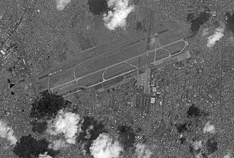
162 Ikonos satellite image of Tan Son Nhut Airbase, Ikonos satellite image of Tan Son Nhut Airbase, 2002.


163 Aerial photograph of Tan Son Nhut Airbase, Base Map of Tan Son Nhut Airbase, 1968.


164 Ranch Hand Area (Charlie Sector) Ikonos satellite image of Tan Son Nhut Airbase (2003) showing former Ranch Hand Area. US Military Map of Tan Son Nhut Airbase (1:50,000 scale).
SUMMARY OF DIOXIN CONTAMINATION AT THE BIEN HOA, PHU CAT AND DA NANG AIRBASES, VIET NAM
 SUMMARY OF DIOXIN CONTAMINATION AT THE BIEN HOA, PHU CAT AND DA NANG AIRBASES, VIET NAM Hatfield Consultants and Office of the National Steering Committee 33 Research Supported by a Grant from the Ford
HOW DID HATFIELD CONSULTANTS GET INVOLVED IN AGENT ORANGE/DIOXIN IN VIET NAM?
 HOW DID HATFIELD CONSULTANTS GET INVOLVED IN AGENT ORANGE/DIOXIN IN VIET NAM? By Dr. Wayne Dwernychuk Environmental Scientist In the late 1980 s in British Columbia, Canada it was determined by government
Author(s) Issue Date Text Version publisher. DOI. rights
 Issue Date Text Version publisher. DOI. rights") Title Author(s) Citation ASSESSMENT OF DIOXIN CONTAMINATION IN THE ENVIRONMENT AND HUMAN POPULATION IN THE VICINITY OF DIOXIN HOTSPOT IN DA NANG AIRBASE, SOUTH VIETNAM N, H. Minh; L, K. Son; T, G. Boivin;
Title Author(s) Citation ASSESSMENT OF DIOXIN CONTAMINATION IN THE ENVIRONMENT AND HUMAN POPULATION IN THE VICINITY OF DIOXIN HOTSPOT IN DA NANG AIRBASE, SOUTH VIETNAM N, H. Minh; L, K. Son; T, G. Boivin;
Environmental and Human Health Assessment of Dioxin Contamination at Bien Hoa Airbase, Viet Nam
 Environmental and Human Health Assessment of Dioxin Contamination at Bien Hoa Airbase, Viet Nam Final Report August 2011 Prepared by: Office of the National Steering Committee 33, MONRE Ha Noi, Viet Nam
AGENT ORANGE/DIOXIN HOT SPOTS A LEGACY OF US MILITARY BASES IN SOUTHERN VIETNAM
 AGENT ORANGE/DIOXIN HOT SPOTS A LEGACY OF US MILITARY BASES IN SOUTHERN VIETNAM L. WAYNE DWERNYCHUK a, HOANG DINH CAU b, CHRISTOPHER T. HATFIELD a, THOMAS G. BOIVIN a, TRAN MANH HUNG b, PHUNG TRI DUNG
Lessons Learned: NAMA development in Vietnam
 Lessons Learned: NAMA development in Vietnam Dr. Huynh Thi Lan Huong Director of Climate Change Research Center Institute of Meteorology, Hydrology and Environment Ministry of Natural Resources and Environment,
Vietnam seaport system. PHAM ANH TUAN Deputy General Director Portcoast Consultant Corporation
 1 Vietnam seaport system PHAM ANH TUAN Deputy General Director Portcoast Consultant Corporation 4 LARGE INFRASTRUCTURE PROJECT CONFERENCE 2018 BUILD FOR LIFE HCMC - OCTOBER, 2018 PRESENTED BY: PHAM ANH
Agent Orange and the Environment: From Research to Remediation
 Agent Orange and the Environment: From Research to Remediation Phung Tuu Boi Center for Assistance in Nature Conservation and Community Development, Vietnam and advisor to the Vietnam Victims of Agent
Low Carbon Development and Nationally Appropriate Mitigation Action - Status and the Development of Wind and Waste NAMA
 Low Carbon Development and Nationally Appropriate Mitigation Action - Status and the Development of Wind and Waste NAMA Dr. Huynh ThiLanHuong Director of Climate Change Research Center Institute of Meteorology,
Asia: Water Opportunity Workshop
 Business Opportunities in Water & Wastewater in Vietnam Asia: Water Opportunity Workshop Nguyen Dang Anh Thi Consultant Energy, Environment & Sustainability 15 th September 2017 CONTENTS I. Vietnam: key
The Regional Capacity Development Program for Management of Health Risks of Persistent Organic Pollutants (POPs) in South East Asia
 in South East Asia") The Regional Capacity Development Program for Management of Health Risks of Persistent Organic Pollutants (POPs) in South East Asia DA NANG AIRBASE RISK ASSESSMENT USING THE POPs TOOLKIT Prepared for:
The Regional Capacity Development Program for Management of Health Risks of Persistent Organic Pollutants (POPs) in South East Asia DA NANG AIRBASE RISK ASSESSMENT USING THE POPs TOOLKIT Prepared for:
DECISION Approving a program to strengthen and upgrade the sea dyke system From Quang Ngai to Kien Giang
 PRIME MINISTER ------- No: 667/QD-TTg SOCIALIST REPUBLIC OF VIETNAM Independence - Freedom - Happiness -------------- Hanoi, 27 2005 2009 DECISION Approving a program to strengthen and upgrade the sea
1.0 INTRODUCTION 1.1 SELECTED SITE
 1.0 INTRODUCTION The enclosed report for the Regional Capacity Building Program for Health Risk Management of Persistent Organic Pollutants (POPs) in South East Asia (POPs Project) provides a screening
LIST OF CONSTRUCTION MATERIALS COMPANIES IN VIETNAM
 LIST OF CONSTRUCTION MATERIALS COMPANIES IN VIETNAM 1 COSEVSO 19 - Cement Company / Midland Construction Corporation Add: Hoa Khuong Commune, Hoa Vang District, Da Nang City Phone: 84-511-378 0329 Fax:
NEW FEED-IN- TARIFF MECHANISM FOR VIETNAMESE SOLAR ENERGY PROJECTS
 BRIEFING NEW FEED-IN- TARIFF MECHANISM FOR VIETNAMESE SOLAR ENERGY PROJECTS FEBRUARY 2019 THE VIETNAMESE GOVERNMENT HAS CONSIDERED NEW SOLAR FEED-IN-TARIFFS WHICH WILL BE IN PLACE FOR APPROXIMATELY TWO
Preparatory Study for Development Study (M/P or F/S)
") Preparatory Study for Development Study (M/P or F/S) 1. Title of the Cooperation Project and Name of the Project Proponent (1) Title of the Cooperation Project The Study for Groundwater Development in
Preparatory Study for Development Study (M/P or F/S) 1. Title of the Cooperation Project and Name of the Project Proponent (1) Title of the Cooperation Project The Study for Groundwater Development in
2.0 PRELIMINARY DATA COLLECTION
 2.0 PRELIMINARY DATA COLLECTION 2.1 SAMPLING PLAN CONSIDERATIONS Supplementary environmental field data were collected at the site to characterize POPs contaminant concentrations in various environmental
MSMEs' Competitiveness and Innovation in the Digital Age
 2016/ISOM/SYM/013 Session IV MSMEs' Competitiveness and Innovation in the Digital Age Submitted by: OECD Symposium on Priorities for APEC 2017 Ha Noi, Viet Nam 8 December 2016 SYMPOSIUM ON APEC 2017 PRIORITIES
OVERVIEW OF RURAL WATER SUPPLY IN VIETNAM
 OVERVIEW OF RURAL WATER SUPPLY IN VIETNAM Le Thieu Son Director NCERWASS Hanoi, July 2016 General Information: Location: South East Asian region The Capital: Hanoi City Area: about 331,000 km 2 Population
Lam Du Son Vice President of EVN, Vietnam
 BRIEF INTRODUCTION TO ELECTRICITY SECTOR IN VIET NAM Lam Du Son Vice President of EVN, Vietnam I. OVERVIEW OF VIETNAM ELECTRICITY SECTOR. A. EVN Electricity of Vietnam Established in 994. Main responsibility
The Red River Delta Transport Development Program
 Vietnam-Japan Joint Program Evaluation Study Chapter 2 The Red River Delta Transport Development Program 2-1 Overview of Vietnam s Transport Sector Vietnam s transport sector provides a full range of transport
VUNG TAU PETRO JSC 2013
 VUNG TAU PETRO JSC 2013 INVESTMENT HIGHLIGHTS The demand of petroleum port and depot in Vietnam is currently very high, especially in the South All current petroleum ports in Vietnam are small in terms
WORK PLAN. A. Background
 WORK PLAN STRENGTHENING CONTAMINATED SOIL MONITORING IN VIETNAM AECEN Twinning Partnership: Ministry of Natural Resources and Environment of Vietnam and Ministry of Environment of Korea A. Background Soil
Vietnam Industrial & Logistics Real Estate Market Update Mr. Greg Ohan
 Vietnam Industrial & Logistics Real Estate Market Update Mr. Greg Ohan Deputy CEO September 2018 AGENDA 01 BW Industrial Development Intro 02 Recent Headlines - Industrial & Logistics 03 Market Update
Vietnam- NCAP Study CLIMATE CHANGE IMPACTS IN HUONG RIVER BASIN AND ADAPTATION IN THUA THIEN HUE PROVINCE
 Vietnam- NCAP Study CLIMATE CHANGE IMPACTS IN HUONG RIVER BASIN AND ADAPTATION IN THUA THIEN HUE PROVINCE Project Expert Team IMHEN Prof. Dr. Tran Thuc, Project Director Mr. Le Nguyen Tuong, Project Coordinator
ASSESSMENT OF AGENT ORANGE- DIOXIN IN SOIL AND ON THE AQUATIC PRODUCTS IN HO CHI MINH CITY
 ASSESSMENT OF AGENT ORANGE- DIOXIN IN SOIL AND ON THE AQUATIC PRODUCTS IN HO CHI MINH CITY Departement of Research and development Center of Analytical service and experimentation (CASE) HoChiMinh city,
TSERAWG Technical Guidance
 Page 1 of 7 TSERAWG Technical Guidance This paper has been technically reviewed and endorsed by the Tri-Service Environmental Risk Assessment Working Group for use by Army, Navy, and Air Force Personnel
U versity. University
 SHARE SHARE. LEARN.. NETWORK www.vietnamsupplychain.com Directory U versity D ctory Directory Directory 2 www.vietnamsupplychain.com GENERAL INFORMATION Ho Chi Minh city has 41 universities and colleges
3 Classification of post items to the letters according to their size (Conv., art. 14; Regs., art. RL 121.2) No
 No") Currency : VNÐ Basic services Mail classification system (Conv., art. 13.3; Regs., art. RL 120) 1 Based on speed of treatment of items (Regs., art. RL 120.2): 1.1 Priority and non-priority items may weigh
Currency : VNÐ Basic services Mail classification system (Conv., art. 13.3; Regs., art. RL 120) 1 Based on speed of treatment of items (Regs., art. RL 120.2): 1.1 Priority and non-priority items may weigh
GREENc ffee GREENCOFFEE INFORMATION SERVICES
 GREENCOFFEE INFORMATION SERVICES GREENc COFFEE PRODUCTION IN THE CENTRAL HIGHLANDS OF VIETNAM IS THREATENED BY THE IMPACT OF CLIMATE CHANGE, WATER SHORTAGES & LOW FARMER INCOME. Challenges to sustain productivity
VIE: Mong Duong 1 Thermal Power Plant
 7 th Independent Monitoring Report September 2011 VIE: Mong Duong 1 Thermal Power Plant Prepared by the Development Research and Consultancy Center (DRCC) for Viet Nam Electricity (EVN) Thermal Power Project
INTRODUCTION. 1 Proposed Plan for the Former Lee Field Naval Air Station Landfill Area 2 Site
 1 Proposed Plan for the Former Lee Field Naval Air Station Landfill Area 2 Site U.S. Army Corps of Engineers, Jacksonville District Formerly Used Defense Site Program PROPOSED PLAN for the LANDFILL AREA
CURRICULUM VITAE. CV Nguyen Thi Hue, March 2013 Page 1 GENERAL INTRODUCTION
 CURRICULUM VITAE GENERAL INTRODUCTION Full name: NGUYEN THI HUE Sex: Female Date of birth: 16 th March 1977 Education: MSc Nationality: Vietnamese Civil status: Married Background: Soil Science Professional
Ex-ante Evaluation - 1 -
 Ex-ante Evaluation 1. Name of the Project Country: The Socialist Republic of Vietnam Project: Hue City Water Environment Improvement Project (Loan Agreement: March 31, 2008; Loan Amount: 20,883 million
Overview of Water Environmental Pollution in Vietnam
 Overview of Water Environmental Pollution in Vietnam Nguyen Thi Hue Institute of Environmental Technology (IET), Vietnamese Academy of Science and Technology(VSAT). 18-Hoang Quoc Viet R., Caugiay distr.,hanoi,vietnam
Building Urban Climate Resilience
 Published March 2017 Building Urban Climate Resilience Experiences from the Asian Cities Climate Change Resilience Network (ACCCRN) program in Viet Nam Authors abstract ISET-VIETNAM Phong Tran, Technical
EVALUATING AND FORECASTING FLOODING IN HO CHI MINH CITY USING MIKE FLOOD MODEL
 EVALUATING AND FORECASTING FLOODING IN HO CHI MINH CITY USING MIKE FLOOD MODEL Bui Ta Long, Nguyen Thai Hoa, Nguyen Ngoc Khai Department of Environmental Informatics Institute of Environment and Resources,
Pham Huy Toan Branch of Viet Nam Maritime Administration in Ho Chi Minh City
 Pham Huy Toan Branch of Viet Nam Maritime Administration in Ho Chi Minh City Yangon, 09 Octorber 2018 10/10/2018 1 Institution Contents 1 National Maritime Transport Strategy Infrastructures and operation
APPENDIX M: Hazardous Waste Technical Report
 APPENDIX M: Hazardous Waste Technical Report M.1 Existing Conditions A hazardous waste review was conducted to provide preliminary information regarding the potential presence of any hazardous substances
WVV AP Development Facilitator - Da Bac, Hoa Binh
 WVV AP Development Facilitator - Da Bac, Hoa Binh Location: [Asia & Pacific] [Vietnam] Town/City: Vietnam Category: Field Operations Job Type: Fixed term, Full-time World Vision is a Christian relief and
COMPANY PROFILE 2018
 COMPANY PROFILE 2018 HEAD OFFICE 145-147147 Nguyen Tat Thanh Str., District 4, Ho Chi Minh City, Vietnam Tel:(84-28) 8) 38255389 - Fax:(84-28) 8) 39405331 Email: headoffice@vinalinklogistics.com 2 About
Japanese ODA loan. Ex-ante Evaluation
 Japanese ODA loan Ex-ante Evaluation 1. Name of the Project Country: The Socialist Republic of Viet Nam Project: North-South Expressway Construction Project (Ben Luc Long Thanh Section)(II) L/A signed
Implementation Status & Results Vietnam Second Transmission and Distribution Project (P084871)
") losure Authorized Public Disclosure Authorized Public Disclosure Authorized Public Disclosure Authorized The World Bank Implementation Status & Results Vietnam Second Transmission and Distribution Project
losure Authorized Public Disclosure Authorized Public Disclosure Authorized Public Disclosure Authorized The World Bank Implementation Status & Results Vietnam Second Transmission and Distribution Project
ECSI Number: Responsible Party: Klamath County. QTime Number: Entry Date: 9/22/04 (VCP)
") ECSI Number: 1213 Responsible Party: Klamath County QTime Number: 37941 Entry Date: 9/22/04 (VCP) Proposed Remedial Action Staff Report - Addendum Chiloquin Forest Products Chiloquin, Klamath County, Oregon
ECSI Number: 1213 Responsible Party: Klamath County QTime Number: 37941 Entry Date: 9/22/04 (VCP) Proposed Remedial Action Staff Report - Addendum Chiloquin Forest Products Chiloquin, Klamath County, Oregon
PAPI 2010 HA TINH PROFILE. The Viet Nam Governance and Public Administration Performance Index. Introduction: What is PAPI?
 The Viet Nam Governance and Public Administration Performance Index PAPI 2 HA TINH PROFILE Introduction: What is PAPI? Contents Introduction: What is PAPI? Overall PAPI scores for Dimensional Performance
FLOOD MANAGEMENT IN THE RED THAI BINH RIVER BASIN VIET NAM
 FLOOD MANAGEMENT IN THE RED THAI BINH RIVER BASIN VIET NAM By Dr. To Trung Nghia Director of Institute of Water Resources Planning Chief of the Red Thai Binh RBO Office E-mail: iwrp.hanoi@hn.vnn.vn INTRODUCTION
COMPREHENSIVE REPORT
 MINISTRY OF NATURAL RESOURCES AND ENVIRONMENT OFFICE OF NATIONAL STEERING COMMITTEE (OFFICE 33) Project Environmental Remediation of Dioxin Contaminated Hotspots in Vietnam COMPREHENSIVE REPORT AGENT ORANGE/DIOXIN
METHODOLOGY FOR PARTICIPATORY LAND USE PLANNING AND FOREST LAND ALLOCATION
 Page 1 of 9 Ministry of Agriculture and Rural Development (MARD) Food and Agriculture Organization of the United Nations (FAO) Project Country Capacity Strengthening or NFAP Implementation in Vietnam GCP/VIE/020/ITA
Decentralized Trade Support Services for Strengthening the Competitiveness of Vietnamese SMEs
 Decentralized Trade Support Services for Strengthening the Competitiveness of Vietnamese SMEs NGUYỄN T. MINH THÚY Deputy National Program Director 6/2016 Content Introduction Figures Highlighted/Lessons
FOREST LAND USE PLANNING AND FOREST LAND ALLOCATION IN DONG TAM COMMUNE - DONG PHU DISTRICT BINH PHUOC PROVINCE
 Page 1 of 10 Management Board of Project GCP/VIE/020/ITA Dong Phu District, Binh Phuoc Province REPORT ON FOREST LAND USE PLANNING AND FOREST LAND ALLOCATION IN DONG TAM COMMUNE - DONG PHU DISTRICT BINH
PORT AND LOGISTICS INFRASTRUCTURE IN VIETNAM, OPPORTUNITES FOR COOPERATIVE DEVELOPMENT. MSc. NGUYEN XUAN TINH Busan, Oct 2018
 PORT AND LOGISTICS INFRASTRUCTURE IN VIETNAM, OPPORTUNITES FOR COOPERATIVE DEVELOPMENT MSc. NGUYEN XUAN TINH Busan, Oct 2018 Vietnam IMO s member state Area: 331.699 km² EEZ: 1million km² Population: 96,566,780
Tourism Human Resources Develoment in Phu Quoc, Vietnam
 Tourism Human Resources Develoment in Phu Quoc, Vietnam Phan Quan Viet Ph.D. Van Lang University, Vietnam Received: September 12, 2018 Accepted: September 28, 2018 Published: November 12, 2018 doi:10.5296/ber.v8i4.13887
UN-EU GUIDELINES FOR FINANCING OF LOCAL COSTS IN DEVELOPMENT CO-OPERATION WITH VIET NAM. Version 2013
 UN-EU GUIDELINES FOR FINANCING OF LOCAL COSTS IN DEVELOPMENT CO-OPERATION WITH VIET NAM Version 2013 ISSUED BY UN AGENCIES IN VIET NAM, THE EU DELEGATION TO VIET NAM AND THE MINISTRY OF PLANNING AND INVESTMENT
Saigon Newport Holding Company 2
 August, 2009 Popula)on: 86.21 millions people GDP 2008: 1477717 billions VND GDP growth: 4.59 % ( first 9 months of 2009 ) Q1: 3.11%; Q2: 4.46%; Q3: 5.76% GDP by sector: Agriculture 22.1%, Industry 39.73%,
TERM OF REFERENCE The analysis on selected agriculture and fishery value-chains in An Giang
 TERM OF REFERENCE The analysis on selected agriculture and fishery value-chains in An Giang 1. Background and Rationale Child labour (CL) is a challenge in Vietnam as well as in many countries. During
OCCASION DISCLAIMER FAIR USE POLICY CONTACT. Please contact for further information concerning UNIDO publications.
 OCCASION This publication has been made available to the public on the occasion of the 50 th anniversary of the United Nations Industrial Development Organisation. DISCLAIMER This document has been produced
C O M PA N Y P R O F I L E
 COMPANY PROFILE CONTENTS 4 7 10 12 13 14 16 Highlighted Figures Company Overview Subsidiaries & Affiliated Companies Our Technology Our Partners Our Leadership Team Our Core Competencies DNP WATER WWW.DNPWATER.VN
LIGHTHOUSE CORPORATION
 LIGHTHOUSE CORPORATION COMPANY PROFILE ISO 9001:2008 GENERAL & MAIN CONTRACTOR INDUSTRIAL FACTORY HIGH - RISE BUILDING OFFICE BUILDING HOTEL & VILLA RESORT & SPA INTERIOR DECORATING INFRASTRUCTURE Partnering
PETROVIETNAM The Partner of Choice
 November 2013 PETROVIETNAM The Partner of Choice Vietnam National Oil & Gas Group Website: http://english.pvn.vn/invest/ Outline Petrovietnam - Overview Exploration & Production Gas Industry Refining &
OSWER DIRECTIVE Role of the Baseline Risk Assessment in Superfund Remedy Selection Decisions
 UNITED STATES ENVIRONMENTAL PROTECTION AGENCY WASHINGTON, D.C. 20460 OFFICE OF SOLID WASTE AND EMERGENCY RESPONSE OSWER DIRECTIVE 9355.0-30 MEMORANDUM SUBJECT: FROM: TO: Role of the Baseline Risk Assessment
7. LANGUAGES/ DEGREE OF PROFICIENCY English Excellent
 CIRICULUM VITAE 1. NAME Huynh Thi Lan Huong 2. DATE OF BIRTH 10 March 1971 3. NATIONALITY Vietnamese 4. EDUCATION B. Eng., (Hydrology and Environment), Hanoi University of Water Resources, Hanoi, Vietnam,
POPs and POPs Wastes Management and Technological Considerations Practice in Viet Nam
 POPs and POPs Wastes Management and Technological Considerations Practice in Viet Nam By Dao Xuan Lai Head of Sustainable Development Unit, UNDP Viet Nam Presentation at 4th Regional 3R Forum in Asia,
The potential, orientation of Vietnamese port system
 International Journal of Recent Engineering Research and Development () The potential, orientation of Vietnamese port system Van Trung Tran, Danh Chan Nguyen Ho Chi Minh University of Transport Abstract:
CHAPTER 1 INTRODUCTION
 CHAPTER 1 INTRODUCTION The Comprehensive Environmental Response, The goal of the Superfund human health Compensation, and Liability Act of 1980, as evaluation process is to provide a framework for amended
PIMS 3685: Environmental Remediation of Dioxin Contaminated Hotspots in Viet Nam
 Global Environmental Facility PIMS 3685: Environmental Remediation of Dioxin Contaminated Hotspots in Viet Nam Project Inception Report 1 Inception Report for Environmental Remediation of Dioxin Contaminated
EXECUTIVE SUMMARY RISK ANALYSIS (VOLUME 1)
") EXECUTIVE SUMMARY RISK ANALYSIS (VOLUME 1) The MRC Navigation Programme (NAP) was formulated in 2003 in close cooperation with Member Countries and other regional stakeholders. Its five components share
EXECUTIVE SUMMARY RISK ANALYSIS (VOLUME 1) The MRC Navigation Programme (NAP) was formulated in 2003 in close cooperation with Member Countries and other regional stakeholders. Its five components share
None of the samples collected from any of the areas contained concentrations of lead greater than the residential soil PRG of 400 mg/kg.
 background area, and all of the samples collected from the background areas contained copper at concentrations greater than 50 mg/kg. Thus, concentrations of copper in the muliwai samples appear to be
International Labour Organization (ILO) project (VNM/15/52/USA)
 project (VNM/15/52/USA)") International Labour Organization (ILO) safeyouth@work project (VNM/15/52/USA) Terms of Reference for a Service Contract: Assessment of current situation for developing a decree on voluntary injury insurance
International Labour Organization (ILO) safeyouth@work project (VNM/15/52/USA) Terms of Reference for a Service Contract: Assessment of current situation for developing a decree on voluntary injury insurance
SOCIALIST REPUBLIC OF VIETNAM Independence - Freedom - Happiness No. 355/QD-TTg Hanoi, February 25 th 2013 DECISION
 THE PRIME MINISTER -------- SOCIALIST REPUBLIC OF VIETNAM Independence - Freedom - Happiness ---------------- No. 355/QD-TTg Hanoi, February 25 th 2013 DECISION APPROVING THE ADJUSTED STRATEGY FOR VIETNAM
CARGO CARE Logistics. Allied To Your Business. Introduction
 CARGO CARE Logistics Allied To Your Business Introduction 2 10 15 50 OUR KEY MILESTONE HUMAN DEVELOPMENT Service Development Air Customs Air Trucking Customs Air SEA SEA SEA SEA 2009 2010 2014 2015 SEA
No. Conferences - Organizers Time-Avenue Contents Speakers. 1 st session August 3 rd 2016 (13:00-17:00)
") MEETINGS AND CONFERENCES IN THE FRAMEWORK OF VIETNAM FISHERIES INTERNATIONAL EXHIBITION (VIETFISH) 2016 1. Avenue: Saigon Exhibition & Convention Center (SECC), 799 Nguyen Van Linh, District 7, Ho Chi
MEETINGS AND CONFERENCES IN THE FRAMEWORK OF VIETNAM FISHERIES INTERNATIONAL EXHIBITION (VIETFISH) 2016 1. Avenue: Saigon Exhibition & Convention Center (SECC), 799 Nguyen Van Linh, District 7, Ho Chi
cont'd... it will provide the stability required for the construction of an asphalt- surfaced runway, taxiway, and apron system.
 vier N~M cont'd... In December 1961 facilities had to be constructed immedi. ately at Tan Son Nhut AS near Saigon and at bases in Bien Hoa. Da Nang, Pleiku, and Nha Trang. At first tents were set up to
WVV Strategy and Public Engagement Director
 WVV Strategy and Public Engagement Director Location: [Asia & Pacific] [Vietnam] Town/City: Quan Hoan Kiem Category: Strategy, Collaboration, & Innovation Job Type: Fixed term, Full-time * This position
STRATEGY OF VIETNAM TOWARDS ADDRESSING ENVIRONMENT AND CLIMATE RISKS
 STRATEGY OF VIETNAM TOWARDS ADDRESSING ENVIRONMENT AND CLIMATE RISKS BUI CACH TUYEN, Assoc. Prof. Dr. Director General Vietnam Environment Administration ENVIRONMENT AND CLIMATE Vietnam has been facing
ASIAN DISASTER REDUCTION CENTER Visiting Researcher Program (FY2017B)
") JAPAN, 2018 ASIAN DISASTER REDUCTION CENTER Visiting Researcher Program (FY2017B) Viet Nam Country Report 2017 ADRC visiting researcher PHAM HONG THANH Disaster Management Policy And Technology Center
JAPAN, 2018 ASIAN DISASTER REDUCTION CENTER Visiting Researcher Program (FY2017B) Viet Nam Country Report 2017 ADRC visiting researcher PHAM HONG THANH Disaster Management Policy And Technology Center
Current Status of Energy in Viet Nam. Assoc. Prof. Dr. Tran Thuc Director, Institute of Meteorology and Hydrology
 Current Status of Energy in Viet Nam Assoc. Prof. Dr. Tran Thuc Director, Institute of Meteorology and Hydrology Outline Overview Current status of the Vietnamese Energy Sector Policies, Projects and Plans
TRANSPORT INFRASTRUCTURE DEVELOPMENT & LEGAL FRAMEWORK ON PPP INVESTMENT OF VIET NAM
 TRANSPORT INFRASTRUCTURE DEVELOPMENT & LEGAL FRAMEWORK ON PPP INVESTMENT OF VIET NAM Total investment capital required: US$44bn + From State Budget: US$28.9bn (65.7%) for: Contribute to capital of BOT
August 21, 2013 By: Alex James, Yakutat Tlingit Tribe and Bruno Ridolfi, RIDOLFI Inc. YAKUTAT TLINGIT TRIBE
 Tribal Response to Protect the AnkauSaltchucks August 21, 2013 By: Alex James, Yakutat Tlingit Tribe and Bruno Ridolfi, RIDOLFI Inc. History of Yakutat Strategically located for trade Rich history of
Vietnamese ports: Capacity and development orientation
 International Journal of Recent Engineering Research and Development () Vietnamese ports: Capacity and development orientation Phuoc Quy Phong Nguyen, Van Huong Dong Ho Chi Minh University of Transport
Agroecological zoning for extension of climate friendly agriculture in some provinces of Northwest Vietnam
 Agroecological zoning for extension of climate friendly agriculture in some provinces of Northwest Vietnam Nguyê n Đư c Tô Lưu, Phan Văn Thăng, Đặng Xuân Trường NATIONAL MULTI STAKEHOLDER WORKSHOP TOWARDS
UNDP Project Document
 UNDP Project Document Government of Viet Nam United Nations Development Programme PIMS 3685: Environmental Remediation of Dioxin Contaminated Hotspots in Viet Nam ATLAS VNM10 Award 00057593 Project 00071224
Phase 1 - Technical Assessment Kettle River Watershed Management Plan. Request for Proposals
 Phase 1 - Technical Assessment Kettle River Watershed Management Plan Request for Proposals Closing date and time: 4:00 PM, January 28, 2011 Pacific Standard Time Location of proposal closing: Regional
Effective Database Management System Development Report
 Strengthening Capacities to Enhance Coordinated and Integrated Disaster Risk Reduction Actions and Adaptation to Climate Change in Agriculture in the Northern Mountain Regions of Viet Nam Effective Database
EXPERIENCE OF URBAN DEVELOPMENT AND CLIMATE CHANGE ADAPTATION IN DA NANG CITY
 VIET NAM DA NANG Lessons from ACCCRN in Viet Nam Series EXPERIENCE OF URBAN DEVELOPMENT AND CLIMATE CHANGE ADAPTATION IN DA NANG CITY Lessons from the urbanization process of Hoa Tien and Hoa Chau communes,
Initiation of Emerging Contaminants Characterization and Response Actions for Protection of Human Health
 THE ECOS and DoD SUSTAINABILITY WORKGROUP ISSUE PAPER Initiation of Emerging Contaminants Characterization and Response Actions for Protection of Human Health Introduction: The ECOS-DoD Sustainability
Sustainable Sanitation and Hygiene for All Programme (SSH4A) in Nghe An Province. Terms of Reference
 in Nghe An Province. Terms of Reference") Terms of Reference Sanitation hardware value chain analysis in Nghe An province 1. Background 1.1 SNV SNV (The Netherlands Development Organization) works as a capacity development organization in 35 developing
Terms of Reference Sanitation hardware value chain analysis in Nghe An province 1. Background 1.1 SNV SNV (The Netherlands Development Organization) works as a capacity development organization in 35 developing
Summary of Environmental and Social Consideration in Development Study (Preparatory Study)
") Summary of Environmental and Social Consideration in Development Study (Preparatory Study) 1. Full title of the Project The Study on Integrated Development Strategy for Danang City and Its Neighboring
Summary of Environmental and Social Consideration in Development Study (Preparatory Study) 1. Full title of the Project The Study on Integrated Development Strategy for Danang City and Its Neighboring
INTRODUCTION OF SHORT-HAUL TRANSPORTATION
 INTRODUCTION OF SHORT-HAUL TRANSPORTATION SHORT-HAUL TRANSPORTATION SERVICE Bac Ky s container trucking fleet is one of the three biggest in Northen Vietnam with a total of 90 trucks and 160 trailers.
THE ZONING AND CALCULATION OF AREAS ENDURED THE EFFECTS OF CLIMATE CHANGE IN THE LOWER MEKONG RIVER DELTA
 THE ZONING AND CALCULATION OF AREAS ENDURED THE EFFECTS OF CLIMATE CHANGE IN THE LOWER MEKONG RIVER DELTA Abstract The Lower Mekong River Delta (LMRD) are most affected by climate change which causes droughts,
IMPLEMENTATION OF NATIONAL STRATEGY ON CLEAN WATER SUPPLY AND SANITARY IMPROVEMENT FOR THE RURAL AREA IN HO CHI MINH CITY, VIET NAM 1
 IMPLEMENTATION OF NATIONAL STRATEGY ON CLEAN WATER SUPPLY AND SANITARY IMPROVEMENT FOR THE RURAL AREA IN HO CHI MINH CITY, VIET NAM 1 FROM THE NATIONAL STRATEGY Clean water and a sanitary, healthy environment
MOIT FiT Circular No. 02 Decision No. 39
 Renewable Energy Vietnam Client Alert January 2019 For further information, please contact: Fred Burke +84 28 3520 2628 frederick.burke@bakermckenzie.com Dang Chi Lieu +84 24 3936 9341 chilieu.dang@bakermckenzie.com
PROJECT INFORMATION DOCUMENT (PID) CONCEPT STAGE Report No.: AB4343 Project Name. VIETNAM: Haiphong Urban Transport Project Region
 CONCEPT STAGE Report No.: AB4343 Project Name. VIETNAM: Haiphong Urban Transport Project Region") Public Disclosure Authorized Public Disclosure Authorized Public Disclosure Authorized Public Disclosure Authorized PROJECT INFORMATION DOCUMENT (PID) CONCEPT STAGE Report No.: AB4343 Project Name VIETNAM:
Public Disclosure Authorized Public Disclosure Authorized Public Disclosure Authorized Public Disclosure Authorized PROJECT INFORMATION DOCUMENT (PID) CONCEPT STAGE Report No.: AB4343 Project Name VIETNAM:
University of Agriculture & Forestry - Hue University. Châu Thành court, Cai Lậy court & Sắc Tứ pagoda, Tiền Giang
 No. PN Project title Implementing agency 1 6 2 8 3 10 4 18 5 22 6 34 7 40 8 44 9 47 Reducing greenhouse gases by promoting the use of "Advanced cooking table" model Development of environment-friendly
Assessing and Communicating Risk: A Partnership to Evaluate a Superfund Site on Leech Lake Tribal Lands. Executive Summary
 Assessing and Communicating Risk: A Partnership to Evaluate a Superfund Site on Leech Lake Tribal Lands Executive Summary Background This summary highlights findings and output of from a series of panels
Assessing damage of flood by using ALOS data in Thua Thien - Hue Province - Vietnam PI: 063 Tran Dinh Lan (1) and Nguyen Van Thao (2) (1) Vice Directo
 and Nguyen Van Thao (2) (1) Vice Directo") Assessing damage of flood by using ALOS data in Thua Thien - Hue Province - Vietnam PI: 063 Tran Dinh Lan (1) and Nguyen Van Thao (2) (1) Vice Director of Institute of Marine Environment and Resources
Assessing damage of flood by using ALOS data in Thua Thien - Hue Province - Vietnam PI: 063 Tran Dinh Lan (1) and Nguyen Van Thao (2) (1) Vice Director of Institute of Marine Environment and Resources
Briefing on Drought on Mekong Delta
 2016/SOM3/EPWG/016 Agenda Item: 9.3 Briefing on Drought on Mekong Delta Purpose: Information Submitted by: Viet Nam 10 th Emergency Preparedness Working Group Meeting Lima, Peru 15-16 August 2016 THE 10
08 Mar Daily Procurement News of Vietnam
 Daily Procurement News of Vietnam Search Dau-Thau Online Daily Procurement News of Vietnam Procurement items Equipment procurement 9 Vehicles, machinery, equipment 9 Crane truck supply 9 Motorbikes supply
Interim Technical Report
 Interim Technical Report Project Title: From Field to Fork: Nutrition and Food Security in Uplands of Vietnam and Thailand IDRC Project: 107324 Research Organizations involved in the study: Center for
Why do we worry about Dioxins?
 Page 1 Why do we worry about Dioxins? What are they and how are they formed? Dioxins are mixtures of compounds formed by chlorine substitution of the dibenzo-p-dioxin molecule. Mixtures of dioxins are
SOCIALIST REPUBLIC OF VIETNAM Independence - Freedom - Happiness No.: 1037/QĐ-TTg Hanoi, June 24, 2014 DECISION
 THE PRIME MINISTER -------- SOCIALIST REPUBLIC OF VIETNAM Independence - Freedom - Happiness --------------- No.: 1037/QĐ-TTg Hanoi, June 24, 2014 DECISION APPROVAL OF REVISED VIETNAM PORT SYSTEM PLANNING