Healthy lakes add value to our communities. They provide a place to relax and recreate,
|
|
|
- Denis Doyle
- 6 years ago
- Views:
Transcription

1 Pike Lake Eastern Marathon County Lake Study Final Study Results 2013 University of Wisconsin-Stevens Point and Marathon County Staff and Citizens Healthy lakes add value to our communities. They provide a place to relax and recreate, and can stimulate tourism. Like any infrastructure, lakes require attention and good management practices to remain healthy in developed watersheds. The purpose of this study is to learn about the current conditions of the fishery, habitat and aquatic ecosystems in order to help people make informed decisions to preserve 1 P a g e Eastern Marathon what s good County and correct Lake Study any problems UW-Stevens that exist. Point Final Results 2013
2
3 1 P a g e


4 Pike Lake Location Pike Lake Townships of Reid and Elderon East of County Road Y North of Bevent South of Hatley Surface Area: 207 acres Maximum Depth: 31 feet Water Flow Pike Lake is a drainage lake. Water enters Pike Lake primarily from an inlet stream on the northern side of the lake. Groundwater, surface water runoff and direct precipitation also contribute water, but to lesser extents. Water exits Pike Lake through its outlet stream at the south end and through groundwater. 2 P a g e


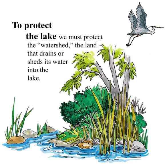
5 Pike Lake Surface Watershed Surface Watershed: The area where water runs off the surface of the land and drains toward the lake. Land uses and land management practices occurring in the watershed affect the water quality in the lake. Land uses and land management also play major roles in how water moves across the landscape and how much water soaks into the ground (for longterm storage) or quickly runs off the land. The surface watershed of Pike Lake is 2,359 acres. The primary land uses in the Pike Lake watershed are agriculture and forests. In general, the lands closest to the lake have the greatest immediate impact on water quality. The lake has development around much of its perimeter. Land use that affects Rice Lake and the stream that drains it also have a direct impact on the quality of water in Pike Lake. 3 P a g e
6 Pike Lake Land Use in the Surface Watershed 4 P a g e

7 Pike Lake Lake Map Groundwater Watershed: The area where water soaks into the ground and travels below ground to the lake. Groundwater slowly contributes water to our lakes throughout the year. Hard surfaces on the landscape prevent water from soaking into the ground and becoming groundwater. This results in less water flowing to the lake during the winter and between rains. The quality of groundwater reflects what is happening on the land surface. Precipitation falling on forested land produces clean groundwater, whereas precipitation falling on lands that have chemical use can leach contaminants to groundwater. Groundwater contamination in central Wisconsin may include nitrogen, pesticides, herbicides and other soluble chemicals originating from septic systems, crops, barnyards, road maintenance, etc. Once in the groundwater, these chemicals slowly move towards a lake or river. The groundwater watershed for Pike Lake is 2,929 acres. The primary land uses in the Pike Lake groundwater watershed are agriculture and forests. In general, the lands adjacent to the lake where groundwater enters the lake have the greatest immediate impact on water quality. Residential development and agriculture are nearest the lake in the areas of groundwater inflow. Land adjacent to the inflow stream also contributes to the water quality in Pike Lake. Pike Lake has residential development around some of its perimeter. Land Use Acres Agriculture 936 Developed 111 Forested 1447 Roads 61 Water 147 Wetland 227 Looking at Groundwater Up Close: Groundwater enters Pike Lake primarily from the north with some groundwater entering in the southeast. No groundwater outflow sites were identified during the groundwater survey. 5 P a g e


8 Pike Lake Groundwater Watershed Shoreland vegetation is critical to a healthy lake s ecosystem. It provides habitat for aquatic and terrestrial animals including birds, frogs, turtles, and many small and large mammals. It also helps to improve the quality of the runoff that is flowing across the landscape towards the lake. Healthy shoreland vegetation includes a mix of tall grasses/flowers, shrubs and trees. The map below shows how far the 0.5 to 3 foot tall vegetation exists landward from the edge of Pike Lake. A greater vegetative buffer provides more habitat and better water quality. 6 P a g e

9 Pike Lake Shoreland Vegetation Pike Lake s shape and depth play major roles in determining: Where aquatic plants can and cannot grow Species of fish and where they live How fast water in the lake warms up and cools down The water quality of the lake Abundance of habitat for species living in the water and on the land 7 P a g e

 were captured during the sampling period.")
10 Pike Lake Fishery Many factors determine which fish species thrive in a lake. Physical factors include the lake s type, depth, surface area, geology and lake bed materials. Water quality in the lake also plays a role: water clouded with sediment or algae reduces the success of visual feeders, while low levels of dissolved oxygen will limit the fish population to those that can tolerate periods with low oxygen. The Pike Lake fish species assemblage is more diverse than surrounding lakes in eastern Marathon County. Being a drainage lake, fish have an opportunity to enter from upstream and downstream systems. Two rusty crayfish (exotic/invasive) were captured during the sampling period. The presence of young bass and abundant sunfish sampling indicates successful reproduction is occurring in Pike Lake. Reproductive success of northern pike could not be determined since no young pike were sampled. More intense population sampling over several seasons would be required to determine reproductive success. Walleye reproduction has been variable in Pike Lake, and no young walleyes were observed during the sampling period. Total catch and length of species in Pike Lake during 2012 fyke netting and seining efforts Total catch and length of species in Pike Lake during 2012 boom shocking survey 8 P a g e

11 Pike Lake Fishery Species occurrence in Pike Lake in 2012 surveys and historical Wisconsin DNR According to records from the Wisconsin DNR, extensive management efforts have been conducted on Pike Lake related to fish and fish habitat since the 1930s. From , Pike Lake was treated with sodium arsenite and copper compounds to control weed growth, manual cutting of aquatic plants, and spraying of shoreline vegetation with other approved herbicides. More environmentally-friendly mechanical control methods began in Fish kills of walleye, yellow perch and northern pike, believed to be related to the occurrence of toxic algae, were first noted in Mortality in bullhead species believed to be related to bacterial infections was reported up until the 1970s. In 1971, eutrophication of Pike Lake was occurring more rapidly than expected due to algae blooms and occasional winter fish kills from low dissolved oxygen. Sporadic reports of winter kills indicate continuing eutrophication issues. Walleye stocking has been prevalent since 1938, although pike was also stocked with some frequency until In 1981, with approval from the Wisconsin DNR, a walleye spawning reef was installed by the Pike Lake Sportsmen Club along the eastern shore, but natural reproduction of walleye was not improved from this effort. Walleyes For Tomorrow installed a second artificial walleye spawning reef after 2006 adjacent to the southern inlet, with better contouring and a larger surface area for the same purpose. Yellow perch have also been stocked in recent years, and an abundant population of perch was present during 2012 sampling. It is not possible to evaluate the effectiveness of these stocking efforts with the limited sampling conducted during this study. In 2006, boy scouts installed three fish cribs constructed of wooden pallets anchored to the bottom. 9 P a g e

12 Pike Lake Fishery Habitat in and near the lake plays a major role in the composition of a fish community. Habitat is a combination of aquatic plants, woody structure and lake substrate. Near the shore is found some of the most important fishery habitat. Coarse woody habitat (CWH) is an important component of a healthy and balanced fishery, playing a key role in the life histories of many fish species. Downed trees, logs and branches along with aquatic plants offer refuge from predators, sheltered substrates for spawning, nurseries for young, and feeding grounds to forage for insects and algae. CWH is very important to other animals that live in or visit a lake, including turtles, frogs, birds and mammals. Coarse woody habitat (CWH) is sparse in Pike Lake. The addition of CWH cover into Pike Lake would benefit the fish community. Gravel areas are used by many fish for spawning habitat, including sunfish (bluegill, pumpkinseed and black bass), where males will construct nests and guard their young. Northern pike spawn in shallow or flooded areas with emergent and floating-leaf vegetation. Black crappie use bulrush habitat on gravel or sand substrates where they construct nests and guard young. Bulrush is present along areas of the western shoreline in Pike Lake. Yellow perch and walleye use near-shore cobble in oxygen-rich environments for spawning. Sand can be important habitat for non-game minnow reproduction. 10 P a g e
13 Pike Lake Aquatic Plants Aquatic plants are the forest landscape within a lake. They provide food for creatures including fish, ducks and turtles, and habitat for fish, invertebrates, and other aquatic animals. They create oxygen in the water and utilize nutrients that would otherwise be used by algae. A healthy lake typically has a variety of aquatic plant species creating diversity that can help to prevent the establishment of aquatic invasive species. Overall, the plant community in Pike Lake is characterized by an above average diversity when compared to other lakes in the Marathon County study, with a total of twenty-one species documented in the 2011 survey. Much of the diversity observed in Pike Lake was limited to bays and undeveloped shores on the western side of the lake. The number of plant species and percent of littoral zone that is vegetated have decreased somewhat since the 2006 aquatic plant survey. Dominant species have changed as well. 11 P a g e

 populations.")

14 Pike Lake Aquatic Plants During a 2011 aquatic plant survey of Pike Lake, 36 percent of the sites sampled had vegetation. The average depth of the sampled sites was 6 feet, with a maximum rooting depth of 11 feet. The three most frequently encountered aquatic species are native to Wisconsin: flat-stem pondweed, coontail and muskgrass. Prior to the survey, Pike Lake had been identified by the Wisconsin DNR as having curly-leaf pondweed (CLP) populations. A separate June 2012 survey documented the presence of curly-leaf pondweed along the entire length of the lake s western shore. Species Richness is a count of the number of plant species found at a survey point. A greater number of species in a lake helps to make the aquatic plant community more resilient to year-to-year changes and aquatic invasive species. More plant species means more diverse habitat and available food sources. Coontail Coontail and flat-stem pondweed are food sources for waterfowl and provide excellent habitat and cover for many fish species. These aquatic plants also support insects that are food for fish and ducklings. Flat-stem pondweed 12 P a g e
15 Pike Lake Aquatic Invasive Species Aquatic Invasive Species are non-native plants or animals that may cause significant harm to a lake s ecosystem. Typically, they are introduced to a lake by hitching a ride on clothing, boats, trailers and other water recreation equipment. Aquatic invasive species can be introduced to a lake accidentally or intentionally. Once in a lake, they may be impossible to completely remove and can be difficult and costly to control. Prevention and early detection are the best ways to keep aquatic invasive species from establishing in a lake. Lakes With Aquatic Invasive Species in Marathon and Northern Portage County, 2012 Lake Name Banded Mystery Snail Chinese Mystery Snail Rusty Crayfish Curly-Leaf Pondweed Eurasian Water Milfoil Marathon County (Shaded lakes are part of Eastern Marathon Co. Lake Study) Big Bass Lake Big Rib River Eau Claire Flowage Flume Creek Johnson Creek Purple Loosestrife Lake Wausau Little Rib River Little Trappe River Lost Lake Mayflower Lake Mission Lake Pike Lake Rice Lake South Branch Embarrass River Spring Brook Trappe River Wadley Lake Wausau Dam Lake Wisconsin River Northern Portage County Tree Lake Plover River Lake DuBay Learn to identify invasive species & look for them in your lake! 13 P a g e


16 Pike Lake Water Quality Lakes go through a natural aging process that results in increased aquatic plant growth, fish, and wildlife over time. Within a lake s watershed, human activity on the land, in a wetland, or in the lake can dramatically accelerate this process. Depending on land management practices, changes in a lake that may have normally taken centuries to occur may take place in decades or even years. The amounts of nutrients, algal growth, and water clarity measurements help to define the age of a lake. Based on these measures, lakes can be classified for comparison to one another. Oligotrophic Lakes Common uses: Swimming Skiing Boating Vegetation of oligotrophic lakes: Very little vegetation Mesotrophic Lakes Common uses: Boating Fishing Vegetation of mesotrophic lakes: Increased vegetation Occasional algal blooms Eutrophic Lakes Common uses: Fishing Wildlife watching Vegetation of eutrophic lakes: Lots of aquatic plants Frequent algal blooms Winter fish kills can occur in shallow lakes due to low oxygen levels. 14 P a g e

17 Pike Lake Water Quality Phosphorus is a major nutrient that can lead to excessive algae and rooted aquatic plant growth in lakes. In fact, one pound of phosphorus entering a lake can result 300 to 500 pounds of algal growth. In fact, one pound of phosphorus entering a lake can result 300 to 500 pounds of algal growth. All Marathon County lakes have either sufficient or excessive nutrients for aquatic plant growth, so these lakes will benefit from limiting the addition of more nutrients. Sources of phosphorus include septic systems, animal waste, storm water runoff, soil erosion, and fertilizers for lawns, gardens and agriculture. Total phosphorus levels measured when Pike Lake was well-mixed (overturn) are displayed in the graph to the left. Overturn sampling during the monitoring period indicated that Pike Lake is a eutrophic lake with a high average total phosphorus level. Water clarity is a measure of how deep light can penetrate (Secchi depth). Clarity is affected by water color, turbidity (suspended sediment), and algae. Water clarity helps determine where rooted aquatic plants can grow. The graph to the left shows water clarity data collected during the growing season in 2011 and It is typical for water clarity to vary throughout the year. The 2011/2012 average Secchi depth readings were relatively consistent with historic averages. 15 P a g e

, green algae (Chlorophyta), and diatoms (Bacillariophyceae).")

18 Pike Lake Water Quality Algae are microscopic, photosynthetic organisms that are important food items in all aquatic ecosystems. Different algal groups increase or decrease during the year and they can be used to analyze a lake s water quality because there are more varieties of algae than fish or aquatic plants. Conclusions can be drawn about water temperature, nutrient availability, and overall water quality of a lake using algal populations. In Marathon County lakes, there are three dominant groups of algae: blue-green algae (Cyanobacteria), green algae (Chlorophyta), and diatoms (Bacillariophyceae). Despite some variation in the seasonal patterns of the algal community, diatoms were the dominant algal group in Pike Lake during both 2011 and The diatoms were represented by a rich species mixture; most are associated with eutrophic waters. These plankton species grow quite densely in colonies and likely contributed to the very low water clarity observed in 2011 and The remaining components of the algal community, green algae and blue-green algae, were minor and like the diatoms are typical of eutrophic lakes. The high total phosphorus value, the low water clarity, and the dense and dominating diatom community found in Pike Lake are typical of a stable eutrophic lake. PERCENT ALGAL COMPOSITION FOR PIKE LAKE IN 2011 AND 2012 Blue-green algae have the widest tolerance range for temperatures and nutrient concentrations. Once wellestablished in a lake, blue-green algae are difficult to control and remove. A few varieties of blue-greens can produce toxins that are potentially harmful to livestock, pets and humans. 16 P a g e


19 Pike Lake Algae Lake sediment can help to tell the history of a lake and changes that may have affected the lake related to water quality, the abundance of aquatic plants, and sedimentation or land use changes in the watershed. These changes are assessed by evaluating the content of the upper layer of the sediment versus lower layers. This information can help to guide management decisions for a lake. Analysis of Pike Lake s sediment core suggests increased disturbance in the lake basin since the time of European land clearing. Over this time period, there have been increases in nutrients to the lake, including phosphorus, and substantial habitat changes. Ragweed generally increases with logging and land clearing but does not peak until the land is prepared for agriculture, which became widespread around the turn of the century. High levels of ragweed pollen between 10 and 12 inches deep probably represent this period. A high ragweed index deeper in the sediment suggests earlier disturbance due to logging or agricultural clearing by Native Americans. This is an example of a sediment core collected from the bottom of a Wisconsin lake. The darker layers indicate organic-rich sediments often due to increased growth of aquatic plants and/or soil erosion. Additional analysis of these layers can help to confirm the source(s). Diatoms are a type of algae sediment. They are wellpreserved in sediments due to silica-based cell walls which resist degradation. Diatom species found in lake sediments in Marathon County. Different species of diatoms are sensitive to water quality; thus, changes in the diatom community from the bottom to the top of the sediment core can reveal how water quality in the lake has changed over time. 17 P a g e


20 Pike Lake Primary Researchers Lake Users: Run boat engines efficiently Observe no/low wake zones Refuel away from water Dispose of trash properly Remove all aquatic plants from boats and trailers Respect wildlife and other lake users Land Owners: Control soil erosion Keep livestock out of lakes and streams Control manure runoff Carefully manage nutrients and pesticides Leave natural shoreland vegetation in place or restore if it has been removed Learn to identify and look for invasive species Home Owners: Leave natural shoreland vegetation in place or restore if it has been removed Leave woody habitat for young fish, turtles and frogs Eliminate the use of fertilizer or use no phosphorus fertilizer Eliminate or minimize use of pesticides Control soil erosion Control runoff from rooftops and hard surfaces Clean up after pets Learn to identify and look for invasive species Stop the Spread of Aquatic Invasive Species! Wetlands and Shorelands: LEARN how to identify invasive plants and animals, and who to contact if found. DO NOT PURCHASE prohibited and restricted species! Whenever possible purchase native plants. NEVER transplant water garden plants or aquarium plants into lakes, streams, wetlands, or storm water ponds. Properly dispose of unwanted plants and animals! REMOVE invasive exotic plants from your landscape and replace them with native plants or non-invasive exotic plants. Scout annually for new invasive plants. AVOID using garden plants from other regions whose invasive potential is poorly understood. Lakes and Rivers: LEARN what Wisconsin invasive plants and animals look like and who to contact if seen in a lake or river. INSPECT your boat, trailer and equipment when traveling to different water bodies and REMOVE any attached aquatic plants or animals (before launching, after loading, and before transporting on a public highway). DRAIN all water from boats, motors, and all equipment after use at a lake. NEVER release live fish, bait or pets into a wetland or water body. Eastern Marathon BUY minnows County from a Wisconsin Lake Study bait dealer. UW-Stevens Only use leftover Point minnows Final at that Results same 2013 water body. 18 P a g e
 Aquatic Plants Jen McNelly (UW-Stevens Point) Cultural Survey Dr.")
 Christine Koeller (UW-Stevens Point) Sediment Core Dr.")
 Water Quality and Watersheds Nancy")
 UW-Stevens Point Graduate and Undergraduate Students Wisconsin DNR Lake")

21 Pike Lake Primary Researchers Algae Dr. Bob Bell (UW-Stevens Point) Aquatic Plants Jen McNelly (UW-Stevens Point) Cultural Survey Dr. Kristin Floress (UW-Stevens Point) Fisheries and Lake Maps Dr. Ron Crunkilton (UW-Stevens Point) and Dr. Justin Sipiorski (UW-Stevens Point) Christine Koeller (UW-Stevens Point) Sediment Core Dr. Samantha Kaplan (UW-Stevens Point) and Paul Garrison (Wisconsin DNR) Project support provided by: Shoreland Assessments and Build Out Dan McFarlane (UW-Stevens Point) Water Quality and Watersheds Nancy Turyk (UW-Stevens Point) Zooplankton Dr. Chris Hartleb (UW-Stevens Point) UW-Stevens Point Graduate and Undergraduate Students Wisconsin DNR Lake Protection grants UW-Stevens Point and UW-Stevens Point Faculty Marathon County Marathon County Citizens For more information about the study: UW- Stevens Point: Nancy Turyk, Marathon County: Shawn Esser, P a g e
Healthy Lakes have value to a community for a number of reasons. They provide a
 Rice Lake Eastern Marathon County Lake Study Preliminary Results 2010-2012 University of Wisconsin-Stevens Point and Marathon County Staff and Citizens Healthy Lakes have value to a community for a number
Healthy lakes add value to our communities. They provide a place to relax and recreate,
 Lost Lake Eastern Marathon County Lake Study Final Study Results 2013 University of Wisconsin-Stevens Point and Marathon County Staff and Citizens Healthy lakes add value to our communities. They provide
Healthy lakes add value to our communities. They provide a place to relax and recreate,
 Lilly Lake Eastern Marathon County Lake Study Final Study Results 2013 University of Wisconsin-Stevens Point and Marathon County Staff and Citizens Healthy lakes add value to our communities. They provide
Healthy lakes add value to a community. They provide a place to relax and
 Mission Lake Eastern Marathon County Lake Study Final Study Results 2013 University of Wisconsin-Stevens Point and Marathon County Staff and Citizens Healthy lakes add value to a community. They provide
Summary Report University of Wisconsin-Stevens Point and Waushara County Staff and Citizens
 Summary Report 2013 University of Wisconsin-Stevens Point and Waushara County Staff and Citizens Round Lake Location WAUSHARA COUNTY LAKES STUDY 1 Pine (Springwater) 18 W. Branch Mill Pond 2 Twin 19 Porters
Water Quality in Mayflower Lake. N. Turyk Water Resource Scientist UW-Stevens Point
 Water Quality in Mayflower Lake N. Turyk Water Resource Scientist UW-Stevens Point Tonight s discussion Water movement Water quality Zoning/Build-outs in the Watersheds Recommendations and Considerations
Water Quality in Rice and Pike Lakes. Ryan Haney Water Resource Specialist Center for Watershed Science and Education UW Stevens Point
 Water Quality in Rice and Pike Lakes Ryan Haney Water Resource Specialist Center for Watershed Science and Education UW Stevens Point Tonight s discussion How do we measure water quality? How is the water
Amherst Mill Pond. Final Results Portage County Lake Study. University of Wisconsin-Stevens Point, Portage County Staff and Citizens.
 Amherst Mill Pond Final Results Portage County Lake Study University of Wisconsin-Stevens Point, Portage County Staff and Citizens March 31, 2005 What can you learn from this study? You can learn a wealth
Mayflower Lake Management Planning Committee UWSP Center for Watershed Science and Education Marathon County Wisconsin Department of Natural
 Mayflower Lake Management Planning Committee UWSP Center for Watershed Science and Education Marathon County Wisconsin Department of Natural Resources Reduces conflicts Addresses problems Allows for proactive
McDill Pond. Final Results Portage County Lake Study. University of Wisconsin-Stevens Point, Portage County Staff and Citizens.
 McDill Pond Final Results Portage County Lake Study University of Wisconsin-Stevens Point, Portage County Staff and Citizens April 5, 2005 What can you learn from this study? You can learn a wealth of
Springville Pond. Final Results Portage County Lake Study. April 12, University of Wisconsin-Stevens Point Portage County Staff and Citizens
 Springville Pond Final Results Portage County Lake Study April 12, 2005 University of Wisconsin-Stevens Point Portage County Staff and Citizens What can you learn from this study? You can learn a wealth
BIG ROCHE A CRI LAKE CHARACTERISTICS
 BIG ROCHE A CRI LAKE CHARACTERISTICS Lake Description Big Roche Cri Lake is located in north central Adams County and has a surface area of 205 acres, a shoreline length of 6.1 mile, a volume of 6,993
Red Rock Lake: A Path Forward
 University of Minnesota Morris Digital Well University of Minnesota Morris Digital Well Center for Small Towns 6-2016 Red Rock Lake: A Path Forward Colette Millard Student - University of Minnesota, Morris
Sunset Lake. Final Results Portage County Lake Study. April 12, University of Wisconsin-Stevens Point, Portage County Staff and Citizens
 Sunset Lake Final Results Portage County Lake Study April 12, 2005 University of Wisconsin-Stevens Point, Portage County Staff and Citizens What can you learn from this study? You can learn a wealth of
Helen Lake. Final Results Portage County Lake Study. April 5, University of Wisconsin-Stevens Point, Portage County Staff and Citizens
 Helen Lake Final Results Portage County Lake Study University of Wisconsin-Stevens Point, Portage County Staff and Citizens April 5, 2005 What can you learn from this study? You can learn a wealth of valuable
Big Chetac and the Red Cedar River Watershed. Dan Zerr University of Wisconsin-Extension Natural Resource Educator
 Big Chetac and the Red Cedar River Watershed Dan Zerr University of Wisconsin-Extension Natural Resource Educator The Water Cycle An area that all drains to a particular stream, river, lake, or ocean.
Northern Chain of Lakes
 Northern Chain of Lakes Presented by Pat Conrad and Joe Pallardy on behalf of the Brown s Creek Watershed District Board of Managers w a t e r I e c o l o g y I c o m m u n i t y Lake by Lake Analysis
Welcome. Thank you for joining us! Lower Mississippi River Watershed Management Organization
 Welcome. Thank you for joining us! Lower Mississippi River Watershed Management Organization Lower Mississippi River Watershed Management Organization Watershed Restoration and Protection (WRAP) Study
Portage Lake Hubbard County
 Prepared in cooperation with the Minnesota Department of Natural Resources Minnesota Lake ID: 9- Area: acres Watershed Area: 6,7 acres Ecoregion: Northern Lakes and Forests (NLF) Portage Lake Hubbard County
Spring Lake. Final Results Portage County Lake Study. University of Wisconsin-Stevens Point Portage County Staff and Citizens.
 Spring Lake Final Results Portage County Lake Study University of Wisconsin-Stevens Point Portage County Staff and Citizens April 7, 2005 What can you learn from this study? You can learn a wealth of valuable
Portage Lake CASS COUNTY
 Portage Lake 11-0204-00 CASS COUNTY Summary Portage Lake is located near Bena, MN in Cass County. It covers 1,539 acres, which places it in the upper 10% of lakes in Minnesota in terms of size. Portage
Tree Lake. Final Results Portage County Lake Study. University of Wisconsin-Stevens Point Portage County Staff and Citizens.
 Tree Lake Final Results Portage County Lake Study University of Wisconsin-Stevens Point Portage County Staff and Citizens April 12, 2005 What can you learn from this study? You can learn a wealth of valuable
2017 Data Report for Portage Lake, Washtenaw County
 Michigan Lakes Ours to Protect 2017 Data Report for Portage Lake, Washtenaw County Site ID: 810248 42.420559 N, 83.921392 W The CLMP is brought to you by: 1 About this report: This report is a summary
STATE OF THE LAKE Environment Report 2012 JOES LAKE
 STATE OF THE LAKE Environment Report 2012 JOES LAKE JOES LAKE WHY WATERSHED WATCH? A lake monitoring program of the Mississippi Valley Conservation Authority Mississippi Valley Conservation Authority (MVCA)
Chapter 2. Watershed Characteristics
 Chapter 2. Watershed Characteristics The Pelican Lakes are glacial lakes formed during the last retreat of the Red River Lobe starting about 13,000 years ago. The soils deposited by the glacier are primarily
2017 Data Report for Rogers Pond, Mecosta County
 Michigan Lakes Ours to Protect 2017 Data Report for 43.6175478 N, 85.4718313 W The CLMP is brought to you by: 1 About this report: This report is a summary of the data that have been collected through
2017 Data Report for Loon Lake, Iosco County
 Michigan Lakes Ours to Protect 2017 Data Report for Loon Lake, Iosco County Site ID: 350078 The CLMP is brought to you by: 1 About this report: This report is a summary of the data that have been collected
2018 Data Report for Pickerel Lake, Kalkaska County
 Michigan Lakes Ours to Protect 2018 Data Report for Pickerel Lake, Kalkaska County Site ID: 400035 44.800559 N, 84.97667 W The CLMP is brought to you by: 1 About this report: This report is a summary of
Freshwater Ecosystems
 Freshwater Ecosystems The types of organisms in an aquatic ecosystem are mainly determined by the water s salinity. As a result, aquatic ecosystems are divided into freshwater and marine ecosystems. Freshwater
Fish Ecology and Management Workshop. Fisheries management options
 Fish Ecology and Management Workshop Fisheries management options Management Options to Enhance Fishing (Lake Assn.) Stocking Artificial Structures Vegetation Control Natural shoreline Other considerations
2017 Data Report for Deer Lake, Alger County
 Michigan Lakes Ours to Protect 2017 Data Report for Deer Lake, Alger County Site ID: 020127 46.48016 N, 86.98277 W The CLMP is brought to you by: 1 About this report: This report is a summary of the data
Lime Lake. Final Results Portage County Lake Study. University of Wisconsin-Stevens Point, Portage County Staff and Citizens.
 Lime Lake Final Results Portage County Lake Study University of Wisconsin-Stevens Point, Portage County Staff and Citizens March 31, 2005 What can you learn from this study? You can learn a wealth of valuable
2017 Data Report for Fern Lake, Grand Traverse County
 Michigan Lakes Ours to Protect 2017 Data Report for Site ID: 280438 44.73475 N, 85.73409 W The CLMP is brought to you by: 1 About this report: This report is a summary of the data that have been collected
STATE OF THE LAKE Environment Report 2012 MISSISSIPPI LAKE
 STATE OF THE LAKE Environment Report 2012 MISSISSIPPI LAKE MISSISSIPPI LAKE WHY WATERSHED WATCH? A lake monitoring program of the Mississippi Valley Conservation Authority Mississippi Valley Conservation
2017 Data Report for Silver Lake, Van Buren County
 Michigan Lakes Ours to Protect 2017 Data Report for Silver Lake, Van Buren County Site ID: 800534 42.3891 N, 86.0599 W The CLMP is brought to you by: 1 About this report: This report is a summary of the
2018 Data Report for. Crystal Lake, Montcalm County
 Michigan Lakes Ours to Protect 218 Data Report for Crystal Lake, Montcalm County Site ID: 5915 43.25584 N, 84.93362 W The CLMP is brought to you by: 1 About this report: This report is a summary of the
2017 Data Report for Oxbow Lake, Oakland County
 Michigan Lakes Ours to Protect 2017 Data Report for Oxbow Lake, Oakland County Site ID: 630666 42.64167 N, 83.477226 W The CLMP is brought to you by: 1 About this report: This report is a summary of the
2017 Data Report for Little Paw Paw Lake, Berrien County
 Michigan Lakes Ours to Protect 2017 Data Report for Site ID: 110765 42.21899 N, 86.29072 W The CLMP is brought to you by: 1 About this report: This report is a summary of the data that have been collected
Suspended Sediments. A lgae. Factors that Affect Water Clarity
 Factors that Affect Water Clarity Water clarity is a measure of the amount of particles in the water, or the extent to which light can travel through the water. There are many ways to express water clarity,
2017 Data Report for Painter Lake, Cass County
 Michigan Lakes Ours to Protect 217 Data Report for Painter Lake, Cass County Site ID: 1418 41.81667 N, 85.99194 W The CLMP is brought to you by: 1 About this report: This report is a summary of the data
STATE OF THE LAKE Environment Report 2013 MACKAVOY LAKE
 STATE OF THE LAKE Environment Report 2013 MACKAVOY LAKE MACKAVOY LAKE WHY WATERSHED WATCH? A lake monitoring program of the Mississippi Valley Conservation Authority Mississippi Valley Conservation Authority
2017 Data Report for Lake Tahoe, Oceana County
 Michigan Lakes Ours to Protect 17 Data Report for Lake Tahoe, Oceana County Site ID: 33 3.1 N,.3 W The CLMP is brought to you by: 1 About this report: This report is a summary of the data that have been
JORDAN LAKE MANAGEMENT6 PLAN PT 2--REVISED 8/16/14 Page 19 ITEM GOALS and ACTION ITEMS WHO WHEN
 JORDAN LAKE MANAGEMENT6 PLAN PT 2--REVISED 8/16/14 Page 19 EDUCATION Goal A: Educate community and public about lake management concerns. 1. Establish community events to encourage & educate the community
8 LITTLE CROSBY LAKE RESULTS
 8 LITTLE CROSBY LAKE RESULTS 8.1 LITTLE CROSBY LAKE BACKGROUND Figure 8-1: View of the south shoreline of. is 8 acres with an average depth of 7 ft and a maximum depth of 34 ft. Little Crosby Lake is a
2017 Data Report for Shingle Lake, Clare County
 Michigan Lakes Ours to Protect 217 Data Report for Shingle Lake, Clare County Site ID: 1818 43.96359 N, 84.95282 W The CLMP is brought to you by: 1 About this report: This report is a summary of the data
Resource Conservation Opportunities and Management Guidelines
 Resource Conservation Opportunities and Management Guidelines The general ecosystem integrity of lakes is dependent on preserving natural habitat components and the processes that sustain them. These include
2017 Data Report for Pleasant Lake, Wexford County
 Michigan Lakes Ours to Protect 2017 Data Report for Pleasant Lake, Wexford County Site ID: 830183 44.3 N, 85.4775 W The CLMP is brought to you by: 1 About this report: This report is a summary of the data
STATE OF THE LAKE Environment Report 2012 CLAYTON LAKE
 STATE OF THE LAKE Environment Report 2012 CLAYTON LAKE CLAYTON LAKE WHY WATERSHED WATCH? A lake monitoring program of the Mississippi Valley Conservation Authority Mississippi Valley Conservation Authority
2017 Data Report for Big Maggie Lake, Iron County
 Michigan Lakes Ours to Protect 2017 Data Report for Big Maggie Lake, Iron County Site ID: 360173 46.01 N, 88.4626 W The CLMP is brought to you by: 1 About this report: This report is a summary of the data
2017 Data Report for Earl Lake, Livingston County
 Michigan Lakes Ours to Protect 217 Data Report for Earl Lake, Livingston County Site ID: 755 2.191 N, 3.95 W The CLMP is brought to you by: 1 About this report: This report is a summary of the data that
2016 Data Report for Barlow Lake, Barry County
 Michigan Lakes Ours to Protect 216 Data Report for Barlow Lake, Barry County Site ID: 8176 42.67559 N, 85.5242 W The CLMP is brought to you by: 1 About this report: This report is a summary of the data
Saving Wetlands. Is saving Lives
 Saving Wetlands Is saving Lives What are Wetlands? areas between water and land What are Wetlands? contain hydric soil - saturated by water. soil lacks oxygen when saturated land that is seasonally wet.
Wolf Lake. Final Results Portage County Lake Study. April 12, University of Wisconsin-Stevens Point, Portage County Staff and Citizens
 Wolf Lake Final Results Portage County Lake Study University of Wisconsin-Stevens Point, Portage County Staff and Citizens April 12, 25 What can you learn from this study? You can learn a wealth of valuable
2017 Data Report for Hoags Lake, Mason County
 Michigan Lakes Ours to Protect 17 Data Report for Hoags Lake, Mason County.171 N,.19575 W The CLMP is brought to you by: 1 About this report: This report is a summary of the data that have been collected
2017 Data Report for Duck Lake, Muskegon County
 Michigan Lakes Ours to Protect 217 Data Report for Duck Lake, Muskegon County Site ID: 61778 43.33785 N, 86.39258 W The CLMP is brought to you by: 1 About this report: This report is a summary of the data
Wakefield Lake TMDL Public Meeting 3/17/2014. Jen Koehler, PE Barr Engineering
 Wakefield Lake TMDL Public Meeting 3/17/2014 Jen Koehler, PE Barr Engineering Outline Project Contacts Introduction to Wakefield Lake Thoughts/Questions/Concerns About TMDL Studies Lake Water Quality and
Lake Water Quality Myths and Misconceptions. Jana Tondu & Vanessa Swarbrick Limnologist s with Alberta Environment and Parks
 Lake Water Quality Myths and Misconceptions Jana Tondu & Vanessa Swarbrick Limnologist s with Alberta Environment and Parks Facts about Alberta Lakes Lake levels fluctuate in response to climate Many of
STATE OF THE LAKE Environment Report 2014 CONSTANCE LAKE
 STATE OF THE LAKE Environment Report 2014 CONSTANCE LAKE CONSTANCE LAKE WHY WATERSHED WATCH? A lake monitoring program of the Mississippi Valley Conservation Authority Mississippi Valley Conservation Authority
2017 Data Report for Arbutus Lake, Grand Traverse County
 Michigan Lakes Ours to Protect 217 Data Report for Arbutus Lake, Grand Traverse County Site ID: 2819 44.65917 N, 85.519726 W The CLMP is brought to you by: 1 About this report: This report is a summary
Clam Lakes (Lower & Upper), Burnett County Four-Phased Lake Management Planning Project Description
, Burnett County Four-Phased Lake Management Planning Project Description") 1 Clam Lakes (Lower & Upper), Burnett County Four-Phased Lake Management Planning Project Description Lake and Watershed Characteristics The Clam Lakes are a combined 1544 acres with Upper Clam Lake essentially
1 Clam Lakes (Lower & Upper), Burnett County Four-Phased Lake Management Planning Project Description Lake and Watershed Characteristics The Clam Lakes are a combined 1544 acres with Upper Clam Lake essentially
2015 Data Report for South Torch Lake, Antrim County
 Michigan Lakes Ours to Protect 2015 Data Report for South Torch Lake, Antrim County Site ID: 050240 44.91590 N, 85.30280 W The CLMP is brought to you by: About this report: This report is a summary of
2017 Data Report for Klinger Lake, St. Joseph County
 Michigan Lakes Ours to Protect 217 Data Report for Klinger Lake, St. Joseph County Site ID: 75136 41.82781 N, 85.543893 W The CLMP is brought to you by: 1 About this report: This report is a summary of
State of the Lake Environment Report Black Lake
 State of the Lake Environment Report 2011 Black Lake Black Lake Why Watershed Watch? The Ribbon of Life is the shallow waters and first 10 metres of shore land around our lakes where the land meets the
JORDAN LAKE MANAGEMENT6 PLAN PT 2--REVISED 8/10/13 Page 19 ITEM GOALS and ACTION ITEMS WHO WHEN
 JORDAN LAKE MANAGEMENT6 PLAN PT 2--REVISED 8/10/13 Page 19 EDUCATION Goal A: Educate community and public about lake management concerns. 1. Establish community events to encourage & educate the community
Natural Shoreline Landscapes on Michigan Inland Lakes
 Natural Shoreline Landscapes on Michigan Inland Lakes Excerpts from Chapters 2 and 3 Session topics Characteristics of natural and altered shorelines Lakes, shorelines, habitat and water quality Considerations
Potato Lake 2010 Project Results and APM Plan. Saturday May 28, 2011 Dave Blumer, Jake Macholl SEH Lake Scientists
 Potato Lake 2010 Project Results and APM Plan Saturday May 28, 2011 Dave Blumer, Jake Macholl SEH Lake Scientists Lake and Aquatic Plant Management Planning Goal: To maintain or improve the overall condition
STATE OF THE LAKE Environment Report 2013 KASHWAKAMAK LAKE
 STATE OF THE LAKE Environment Report 2013 KASHWAKAMAK LAKE KASHWAKAMAK LAKE WHY WATERSHED WATCH? A lake monitoring program of the Mississippi Valley Conservation Authority Mississippi Valley Conservation
H ollow R iver. Stewardship Works! S ubwatershed. Grades. Land Water Wetlands Biodiversity. Not Stressed Not Stressed Not Stressed Vulnerable
 s H ollow R iver Land Water Wetlands Biodiversity S ubwatershed T he Hollow River Subwatershed is 40,863 hectares in size and lies predominantly in the Township of Algonquin Highlands in Haliburton County.
Boy Lake CASS COUNTY
 Boy Lake 11-143- CASS COUNTY Summary Boy Lake is located near Remer, MN in Cass County. It covers 3,452 acres, which places it in the upper 1% of lakes in Minnesota in terms of size. Boy Lake has two main
2016 Data Report for Iron Lake, Iron County
 Michigan Lakes Ours to Protect Data Report for Iron Lake, Iron County.1397 N,.533 W The CLMP is brought to you by: 1 About this report: This report is a summary of the data that have been collected through
Jacqueline Lake. Final Results Portage County Lake Study. University of Wisconsin-Stevens Point, Portage County Staff and Citizens.
 Jacqueline Lake Final Results Portage County Lake Study University of Wisconsin-Stevens Point, Portage County Staff and Citizens April 5, 2005 What can you learn from this study? You can learn a wealth
State of the Lake Environment Report December Mackavoy Lake
 State of the Lake Environment Report December 2003 Mackavoy Lake Mackavoy Lake Mackavoy Lake is located in the Township of Addington Highlands. Mackavoy Lake is a headwater lake of the Mississippi River
Fountain Lake. Final Results Portage County Lake Study. April 5, University of Wisconsin-Stevens Point Portage County Staff and Citizens
 Fountain Lake Final Results Portage County Lake Study April 5, 2005 University of Wisconsin-Stevens Point Portage County Staff and Citizens What can you learn from this study? You can learn a wealth of
Long Lake ( ) Aquatic Vegetation Survey
 Aquatic Vegetation Survey") Long Lake (15-0057-00) Aquatic Vegetation Survey 22796 County Highway 6 Detroit Lakes, MN 56501 (218) 846-1465 www.rmbel.info Lake: Long Lake DOW Number: 15-0057-00 Date of inspection: 7/14/ 2015 County:
Long Lake (15-0057-00) Aquatic Vegetation Survey 22796 County Highway 6 Detroit Lakes, MN 56501 (218) 846-1465 www.rmbel.info Lake: Long Lake DOW Number: 15-0057-00 Date of inspection: 7/14/ 2015 County:
Osher Course. What Lies Beneath the Inland Bays?
 Osher Course What Lies Beneath the Inland Bays? Objectives for Course Describe the Delaware Inland Bays and their tributaries Illustrate the ecology and importance of estuaries Demonstrate the threats
Gull Lake CASS & CROW WING COUNTIES
 Gull Lake 11-0305-00 CASS & CROW WING COUNTIES Summary Gull Lake is located just northwest of Brainerd, Minnesota, on the border of Cass and Crow Wing Counties. It covers 9,947 acres, which places it in
Riparian Areas. 101 An overview. Prepared by: Jacque Sorensen, M.Sc. TRU Department of Natural Resource Sciences
 Riparian Areas 101 An overview Prepared by: Jacque Sorensen, M.Sc. TRU Department of Natural Resource Sciences February 11, 2015 Presented for the Gardom Lake Planning Committee Today s focus Riparian
2016 Summit Lake Water Quality Report Prepared by Thurston County Environmental Health Division
 ! 216 Summit Lake Water Quality Report Prepared by Thurston County Environmental Health Division PART OF TOTTEN INLET WATERSHED LENGTH OF LAKE: 2.2 miles SHORELINE LENGTH: 5.6 miles LAKE SIZE: 53 acres
2017 Data Report for Spider Lake, Grand Traverse County
 Michigan Lakes Ours to Protect 217 Data Report for Spider Lake, Grand Traverse County Site ID: 28395 44.675987 N, 85.49947 W The CLMP is brought to you by: 1 About this report: This report is a summary
Fish Lake; Echo Bay ( ) Aquatic Vegetation Survey
 Aquatic Vegetation Survey") Fish Lake; Echo Bay (56-0768-00) Aquatic Vegetation Survey 22796 County Highway 6 Detroit Lakes, MN 56501 (218) 846-1465 www.rmbel.info Lake: Fish Lake; Echo Bay DOW Number: 56-0768-00 Date of inspection:
Fish Lake; Echo Bay (56-0768-00) Aquatic Vegetation Survey 22796 County Highway 6 Detroit Lakes, MN 56501 (218) 846-1465 www.rmbel.info Lake: Fish Lake; Echo Bay DOW Number: 56-0768-00 Date of inspection:
Portage County Lake Planning Process
 Portage County Lake Planning Process Lake Leaders Kemp Field Station September 2010 Jen McNelly and Nancy Turyk Center for Watershed Science and Education UW-Stevens Point Types of Planning Emotional Crisis
Shoreland zoning history
 Shoreland zoning history The Wisconsin Constitution, adopted in 1848, says navigable waters are common highways and forever free This led to The waters of WI belong to the people of WI which is the basis
B ig E ast R iver. Stewardship Works! S ubwatershed. Grades. Land Water Wetlands Biodiversity. Not Stressed Not Stressed Not Stressed Vulnerable
 s B ig E ast R iver Land Water Wetlands Biodiversity S ubwatershed T he Big East River Subwatershed is 64,699 hectares in area. Major lakes in the subwatershed include Bella Lake (3.45 km2) and Rebecca
STATE OF THE LAKE Environment Report 2015 MISSISSAGAGON LAKE
 STATE OF THE LAKE Environment Report 2015 MISSISSAGAGON LAKE MISSISSAGAGON LAKE WHY WATERSHED WATCH? A lake monitoring program of the Mississippi Valley Conservation Mississippi Valley Conservation (MVC)
Amnicon & Dowling Lakes Aquatic Plant Management Planning Project
 Amnicon & Dowling Lakes Aquatic Plant Management Planning Project Project Background Aquatic Invasive Species Education, Prevention and Planning Grant Application Submitted to WDNR in August 2011 Awarded
2016 Data Report for Bruin Lake, Washtenaw County
 Michigan Lakes Ours to Protect 1 Data Report for Bruin Lake, Washtenaw County Site ID: 8575.189788 N, 8.39387 W The CLMP is brought to you by: 1 About this report: This report is a summary of the data
2016 Data Report for Magician Lake, Cass County
 Michigan Lakes Ours to Protect 216 Data Report for Magician Lake, Cass County Site ID: 1465 42.649 N, 86.179 W The CLMP is brought to you by: 1 About this report: This report is a summary of the data that
STATE OF THE LAKE Environment Report 2009 BUCKSHOT LAKE
 STATE OF THE LAKE Environment Report 2009 BUCKSHOT LAKE WHY WATERSHED WATCH? A lake monitoring program of the Mississippi Valley Conservation Authority Mississippi Valley Conservation Authority (MVCA)
Pine Lake ( ) Aquatic Vegetation Survey
 Aquatic Vegetation Survey") Pine Lake (15-0149-00) Aquatic Vegetation Survey 22796 County Highway 6 Detroit Lakes, MN 56501 (218) 846-1465 www.rmbel.info Lake: Pine Lake DOW Number: 15-0149-00 Date of inspection: 6/30, 7/2/ 2015
Pine Lake (15-0149-00) Aquatic Vegetation Survey 22796 County Highway 6 Detroit Lakes, MN 56501 (218) 846-1465 www.rmbel.info Lake: Pine Lake DOW Number: 15-0149-00 Date of inspection: 6/30, 7/2/ 2015
Carp Creek 2013 Summary Report
 Monitoring Activity in the Carp River Watershed In 2012, Mississippi Valley Conservation Authority (MVCA) worked with Friends of the Carp River (FCR) on a preliminary assessment of the Carp River. This
4. What is Item A called? a. Eckman dredge b. Secchi disk c. Van Dorn sampler d. Ponar sampler
 Envirothon Questions for AQUATICS station April 24, 2013 1. Eutrophication often results in large fish kills. What is the major cause of these fish kills? a. Oxygen has been depleted due to the decay of
Our Journey Aquatic Invasive Species Eurasian Milfoil (EWM) April 23, 2015
 April 23, 2015") Our Journey 2007 2015 Aquatic Invasive Species Eurasian Milfoil (EWM) April 23, 2015 1 About Beecher Lake Name: Beecher Lake Water body Area: 30 ACRES Maximum Depth: 45 feet Bottom: 5% sand, 5% gravel,
Our Journey 2007 2015 Aquatic Invasive Species Eurasian Milfoil (EWM) April 23, 2015 1 About Beecher Lake Name: Beecher Lake Water body Area: 30 ACRES Maximum Depth: 45 feet Bottom: 5% sand, 5% gravel,
Lakes and Ponds. Questions to consider. Ponds breathe. Sinkhole pond. Oxbow lake. Farm pond. Reservoir
 8 Lakes and Ponds dane johnson / visuals unlimited Oxbow lake Farm pond Sinkhole pond Reservoir albert copley / visuals unlimited Questions to consider 1 2 3 4 5 6 7 How do oxygen levels in ponds change
2017 Data Report for Lake Independence, Marquette County
 Michigan Lakes Ours to Protect 217 Data Report for Lake Independence, Marquette County Site ID: 2149 46.88337 N, 87.711393 W The CLMP is brought to you by: 1 About this report: This report is a summary
Cat Island Chain Restoration, Green Bay
 Cat Island Chain Restoration, Green Bay Victoria Harris, UW Sea Grant January 27, 2005 Southern Green Bay historically provided diverse coastal wetland habitats for fish and wildlife Expansive emergent
Weeds are critical to our eco system...
 Lakes The lake shore (or littoral zone) is the shallow area along the shoreline of a lake or pond which supports diverse communities of rooted plants and serves as food, habitat and protective shelter
Grove Lake Homeowners Guide
 Grove Lake Homeowners Guide Grove Lake: Lake Size 379 acres Located Pope County Minnesota, Grove Lake Township Public Boat Access: Located on Southeast shore of lake off Co. Hwy. 39 Other Boat Access:
2016 Data Report for Klinger Lake, St. Joseph County
 Michigan Lakes Ours to Protect 216 Data Report for Klinger Lake, St. Joseph County Site ID: 75136 41.82781 N, 85.543893 W The CLMP is brought to you by: 1 About this report: This report is a summary of
Jackson Lake Analysis
 Jackson Lake Analysis Lake Zones Lake Zones Limnetic Zone- open water far from shore Light penetrates shallow, allowing photosynthesis Supports phytoplankton (algae, protists, cyanobacteria) which then
BLACK OTTER LAKE DISTRICT
 BLACK OTTER LAKE DISTRICT Storm water Action Plan Action Plan submitted for UW-Madison Course 272630 JDD001 #41967 Great Lakes Water Stewardship Institute 2012 Hortonville Area School District Hortonville