Healthy lakes add value to our communities. They provide a place to relax and recreate,
|
|
|
- Susanna Cunningham
- 5 years ago
- Views:
Transcription

1 Lilly Lake Eastern Marathon County Lake Study Final Study Results 2013 University of Wisconsin-Stevens Point and Marathon County Staff and Citizens Healthy lakes add value to our communities. They provide a place to relax and recreate, and can stimulate tourism. Like any infrastructure, lakes require attention and good management practices to remain healthy in developed watersheds. The purpose of this study is to learn about the current conditions of the fishery, habitat and aquatic ecosystems in order to help people make informed decisions to preserve 1 P a g e what s good and correct any problems that exist.
2
3 1 P a g e


4 Lilly Lake Location Lilly Lake Township of Reid East-northeast of Bevent Surface Area: 85.2 acres Maximum Depth: 5.8 feet Water Flow Lilly Lake is a seepage lake with most of the water entering the lake from groundwater. Surface water runoff and direct precipitation also contribute water, but to lesser extents. Water exits Lilly Lake through groundwater. 2 P a g e


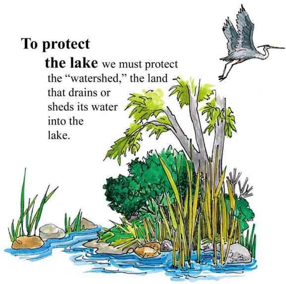
5 Lilly Lake Surface Watershed Surface Watershed: The area where water runs off the surface of the land and drains toward the lake. Land uses and land management practices occurring in the watershed affect the water quality in the lake. Land uses and land management also play major roles in how water moves across the landscape and how much water soaks into the ground (for longterm storage) or quickly runs off the land. The surface watershed of Lilly Lake is 6,480 acres. The primary land uses in the Lilly Lake watershed are agriculture and forests. Residential development is scattered throughout the watershed, mainly in the town of Elderon. Land use around the perimeter of the lake is primarily forests. In general, the land closest to the lake has the greatest immediate impact on water quality. 3 P a g e
6 Lilly Lake Groundwater Watershed Groundwater Watershed: The area where water soaks into the ground and travels below ground to the lake. Groundwater slowly contributes water to our lakes throughout the year. Hard surfaces on the landscape prevent water from soaking into the ground and becoming groundwater. This results in less water flowing to the lake during the winter and between rains. The quality of groundwater reflects what is happening on the land surface. Precipitation falling on forested land produces clean groundwater, whereas precipitation falling on lands that have chemical use can leach contaminants to groundwater. Groundwater contamination in central Wisconsin may include nitrogen, pesticides, herbicides and other soluble chemicals originating from septic systems, crops, barnyards, road maintenance, etc. Once in the groundwater, these chemicals slowly move towards a lake or river. The groundwater watershed for Lilly Lake is 1,236 acres. The primary land uses in the Lilly Lake groundwater watershed are agriculture and forests. Lilly Lake has residential development, forests and wetlands around its perimeter. In general, the land closest to the lake has the greatest immediate impact on water quality. Land Use Acres Agriculture 671 Developed 77 Forested 275 Recreational 2 Roads 38 Water 30 Wetland P a g e

7 Lilly Lake Shoreland Vegetation Shoreland vegetation is critical to a healthy lake s ecosystem. It provides habitat for aquatic and terrestrial animals including birds, frogs, turtles, and many small and large mammals. It also helps to improve the quality of the runoff that is flowing across the landscape towards the lake. Healthy shoreland vegetation includes a mix of tall grasses/flowers, shrubs and trees. The map below shows how far the 0.5 to 3 foot tall vegetation exists landward from the edge of Lilly Lake. A greater vegetative buffer produces more habitat and better water quality. 5 P a g e

8 Lilly Lake Lake Map Lilly Lake s shape and depth play major roles in determining: Where aquatic plants can and cannot grow Types of fish and where they live How fast water in the lake warms up and cools down The water quality of the lake Abundance of habitat for species living in the water and on the land 6 P a g e

9 Lilly Lake Fishery Many factors determine which fish species thrive in a lake. Physical factors include the lake s type, depth, surface area, geology and lake bed materials. Water quality in the lake also plays a role: water clouded with sediment or algae reduces the success of visual feeders, while low levels of dissolved oxygen will limit the fish population to those that can tolerate periods with low oxygen. Total catch and length of fish species in Lilly Lake, 2012 Lilly Lake supports a warm water fish community. In 2012, eight fish species were identified in samples collected by UW-Stevens Point. According to Wisconsin DNR fishery biologists and records, these were the first netting surveys done on Lilly Lake. Due to the shallow depth of Lilly Lake, dip netting was approved and opened to the public after reports of winter fish kills in 1967 and 1975, but no records exist regarding catch. After numerous reports of winter fish kills, the Lilly Lake Protection and Rehabilitation District dredged 44,000 cubic yards of material. A five-foot hole remains near the public beach area of Elderon County Park. No fish stocking records for Lilly Lake were found in the Wisconsin DNR records that were reviewed. The ability to successfully manage the fish populations in Lilly Lake in the future will be limited because of its shallow depth and tendency to winterkill. The presence of young sunfish during sampling indicates successful reproduction is occurring in Lilly Lake. Reproductive success of northern pike could not be determined with the limited sampling data. 7 P a g e

10 Lilly Lake Lake Map Habitat in and near the lake plays a major role in the composition of a fish community. Habitat is a combination of aquatic plants, woody structure and lake substrate. Near the shore is found some of the most important fishery habitat. Coarse woody habitat (CWH) is an important component of a healthy and balanced fishery, playing a key role in the life histories of many fish species. Downed trees, logs and branches along with aquatic plants offer refuge from predators, sheltered substrates for spawning, nurseries for young, and feeding grounds to forage for insects and algae. CWH is very important to other animals that live in or visit a lake including turtles, frogs, birds and mammals. Coarse woody habitat is sparse in Lilly Lake compared to surrounding water bodies in the county. The fish community would benefit from the addition of CWH. Substrate in Lilly Lake is dominated by marl. In the absence of sand and coarser substrates such as gravel, largemouth bass and sunfish are known to build spawning nests on marl. Depressions are deepened until small amounts of coarser substrate, mostly fragments of snail shells, accumulate in the bottom of the nests. In areas of soft substrate, largemouth bass are also reported to spawn on woody habitat swept clear of sediments. 8 P a g e
11 Lilly Lake Aquatic Plants Aquatic plants are the forest landscape within a lake. They provide food for creatures including fish, ducks and turtles, and habitat for fish, invertebrates and other aquatic animals. They create oxygen in the water and utilize nutrients that would otherwise be used by algae. A healthy lake typically has a variety of aquatic plant species creating diversity that can help to prevent the establishment of aquatic invasive species. The aquatic plant community of Lilly Lake is characterized by a below average diversity when compared to other lakes in the Marathon County study. At the time of sampling, water temperatures were warm and most growth had started to die back, possibly contributing to the low species count. Shallow lake depths and thick deposits of muck on the bottom may also be factors. Aquatic plants are distributed throughout the lake, with the greatest species richness on the northern end of the lake. The undeveloped shorelines of Lilly Lake, an asset to the lake and to the plant communities, should remain protected. 9 P a g e

, found at 76% of vegetated sites, followed by white water lily (Nymphaea odorata), found at 40% of vegetated sites.")

12 Lilly Lake Aquatic Plants During the 2012 aquatic plant survey of Lilly Lake, 70 percent of sites sampled had vegetation. The average depth of sampled sites was 4 feet, with a maximum of 6 feet. Only seven species of aquatic plants were found during sampling; no non-native plant species were found. This demonstrates diligence by lake users in cleaning watercraft before entering the lake to prevent nonnative species transfer. The dominant plant species in the survey was coontail (Ceratophyllum demersum), found at 76% of vegetated sites, followed by white water lily (Nymphaea odorata), found at 40% of vegetated sites. Both are native plants that benefit the lake ecosystem and are tolerant of disturbance. Species Richness is a count of the number of plant species found at a survey point. A greater number of species in a lake helps to make the aquatic plant community more resilient to year-to-year changes and aquatic invasive species. More plant species means more diverse habitat and available food sources. Coontail is an important food source for a wide range of waterfowl species. A number of invertebrate and fish species also use the bushy stems and stiff whorls of leaves as habitat, especially in the winter when other aquatic plants have died back. The seeds of the white water lily provide food to waterfowl. The broad, floating leaves of this aquatic species offer shade and shelter to fish. 10 P a g e
13 Lilly Lake Aquatic Invasive Species Aquatic Invasive Species are non-native plants or animals that may cause significant harm to a lake s ecosystem. Typically, they are introduced to a lake by hitching a ride on clothing, boats, trailers and other water recreation equipment. Aquatic invasive species can be introduced to a lake accidentally or intentionally. Once in a lake, they may be impossible to completely remove and can be difficult and costly to control. Prevention and early detection are the best ways to keep aquatic invasive species from establishing in a lake. Lakes With Aquatic Invasive Species in Marathon and Northern Portage County, 2012 Lake Name Big Bass Lake Banded Mystery Snail Chinese Mystery Snail Rusty Crayfish Curly-Leaf Pondweed Eurasian Water Milfoil Marathon County (Shaded lakes are part of Eastern Marathon Co. Lake Study) Big Rib River Eau Claire Flowage Flume Creek Johnson Creek Lake Wausau Little Rib River Little Trappe River Lost Lake Mayflower Lake Purple Loosestrife Mission Lake Pike Lake Rice Lake South Branch Embarrass River Spring Brook Trappe River Wadley Lake Wausau Dam Lake Wisconsin River Northern Portage County Tree Lake Plover River Lake Du Bay Learn to identify invasive species & look for them in your lake! 11 P a g e


14 Lilly Lake Water Quality Lakes go through a natural aging process that results in increased aquatic plant growth, fish and wildlife over time. Within a lake s watershed, human activity on the land, in a wetland, or in the lake can dramatically accelerate this process. Depending on land management practices, changes in a lake that may have normally taken centuries to occur may take place in decades or even years. The amounts of nutrients, algal growth, and water clarity measurements help to define the age of a lake. Based on these measures, lakes can be classified for comparison to one another. Oligotrophic Lakes Common uses: Swimming Skiing Boating Vegetation of oligotrophic lakes: Very little vegetation Mesotrophic Lakes Common uses: Boating Fishing Vegetation of mesotrophic lakes: Increased vegetation Occasional algal blooms Eutrophic Lakes Common uses: Fishing Wildlife watching Vegetation of eutrophic lakes: Lots of aquatic plants Frequent algal blooms Winter fish kills can occur in shallow lakes due to low oxygen levels. 12 P a g e

15 Lilly Lake Water Quality Phosphorus is a major nutrient that can lead to excessive algae and rooted aquatic plant growth in lakes. In fact, one pound of phosphorus entering a lake can result 300 to 500 pounds of algal growth. All Marathon County lakes have either sufficient or excessive nutrients for aquatic plant growth, so these lakes will benefit from limiting the addition of more nutrients. Sources of phosphorus include septic systems, animal waste, storm water runoff, soil erosion, and fertilizers for lawns, gardens and agriculture. Total phosphorus levels measured when Lilly Lake was well-mixed (overturn) are displayed in the graph to the left. Overturn sampling during the monitoring period indicate that Lilly Lake is a eutrophic lake with a high average total phosphorus level. Water clarity is a measure of how deep light can penetrate (Secchi depth). Clarity is affected by water color, turbidity (suspended sediment), and algae. Water clarity helps determine where rooted aquatic plants can grow. The graph to the left shows water clarity data collected during the growing seasons in 2011 and It is typical for water clarity to vary throughout the year. The 2011/2012 average Secchi depth readings were deeper than historic averages, suggesting a recent improvement in water clarity. 13 P a g e

, green algae (Chlorophyta), and diatoms (Bacillariophyceae).")


16 Lilly Lake Water Quality Algae are microscopic, photosynthetic organisms that are important food items in all aquatic ecosystems. Different algal groups increase or decrease during the year and they can be used to analyze a lake s water quality because there are more varieties of algae than fish or aquatic plants. Conclusions can be drawn about water temperature, nutrient availability, and overall water quality of a lake using algal populations. In Marathon County lakes, there are three dominant groups of algae: blue-green algae (Cyanobacteria), green algae (Chlorophyta), and diatoms (Bacillariophyceae). Lilly Lake was dominated by diatoms and green algae during 2011 and The blue-green algae were only a small part of the community. The most common species of diatoms and green algae were small colonial forms that are easy for most small invertebrates and fish to ingest and digest. Additionally, these species do not have poor flavor and are nutritious. These conditions can support a moderate fishery. The total phosphorus value was relatively high and the water clarity was relatively low. This would point to a mildly eutrophic body of water; however, the algal community predicts a mildly to moderately mesotrophic lake. The data may be indicating that Lilly Lake is seeing a slow improvement in water quality conditions, reflected first in the algae populations. PERCENT ALGAL COMPOSITION IN LILLY LAKE IN 2011 AND 2012 If you slip on a slimy, golden-fuzz-covered rock around the edge of your lake, you can blame diatoms (the ones with the glass covering). These algae are preferred food items and they grow abundantly in many different types of water quality. 14 P a g e


17 Lilly Lake What can you do? Lake Users: Run boat engines efficiently Observe no/low wake zones Refuel away from water Dispose of trash properly Remove all aquatic plants from boats and trailers Respect wildlife and other lake users Land Owners: Control soil erosion Keep livestock out of lakes and streams Control manure runoff Carefully manage nutrients and pesticides Leave natural shoreland vegetation in place or restore if it has been removed Learn to identify and look for invasive species Home Owners: Leave natural shoreland vegetation in place or restore if it has been removed Leave woody habitat for young fish, turtles and frogs Eliminate the use of fertilizer or use no phosphorus fertilizer Eliminate or minimize use of pesticides Control soil erosion Control runoff from rooftops and hard surfaces Clean up after pets Learn to identify and look for invasive species Stop the Spread of Aquatic Invasive Species! Wetlands and Shorelands: LEARN how to identify invasive plants and animals, and who to contact if found. DO NOT PURCHASE prohibited and restricted species! Whenever possible purchase native plants. NEVER transplant water garden plants or aquarium plants into lakes, streams, wetlands, or storm water ponds. Properly dispose of unwanted plants and animals! REMOVE invasive exotic plants from your landscape and replace them with native plants or non-invasive exotic plants. Scout annually for new invasive plants. AVOID using garden plants from other regions whose invasive potential is poorly understood. Lakes and Rivers: LEARN what Wisconsin invasive plants and animals look like and who to contact if seen in a lake or river. INSPECT your boat, trailer and equipment when traveling to different water bodies and REMOVE any attached aquatic plants or animals (before launching, after loading, and before transporting on a public highway). DRAIN all water from boats, motors, and all equipment after use at a lake. NEVER release live fish, bait or pets into a wetland or water body. BUY minnows from a Wisconsin bait dealer. Only use leftover minnows at that same water body. 15 P a g e
 Aquatic Plants Jen McNelly(UW-Stevens Point) Cultural Survey Dr.")
 Christine Koeller (UW-Stevens Point) Sediment Core Dr.")
 Water Quality and Watersheds Nancy Turyk (UW-Stevens Point) Zooplankton")


18 Lilly Lake Primary Researchers Algae Dr. Bob Bell (UW-Stevens Point) Aquatic Plants Jen McNelly(UW-Stevens Point) Cultural Survey Dr. Kristin Floress (UW-Stevens Point) Fisheries and Lake Maps Dr. Ron Crunkilton (UW-Stevens Point) and Dr. Justin Sipiorski (UW-Stevens Point) Christine Koeller (UW-Stevens Point) Sediment Core Dr. Samantha Kaplan (UW-Stevens Point) and Paul Garrison (Wisconsin DNR) Shoreland Assessments and Build Out Dan McFarlane (UW-Stevens Point) Water Quality and Watersheds Nancy Turyk (UW-Stevens Point) Zooplankton Dr. Chris Hartleb (UW-Stevens Point) Project support provided by: UW-Stevens Point Graduate and Undergraduate Students Wisconsin DNR Lake Protection grants UW-Stevens Point and UW-Stevens Point Faculty Marathon County Marathon County Citizens For more information about the study: UW- Stevens Point: Nancy Turyk, Marathon County: Shawn Esser, P a g e
Healthy lakes add value to our communities. They provide a place to relax and recreate,
 Pike Lake Eastern Marathon County Lake Study Final Study Results 2013 University of Wisconsin-Stevens Point and Marathon County Staff and Citizens Healthy lakes add value to our communities. They provide
Helen Lake. Final Results Portage County Lake Study. April 5, University of Wisconsin-Stevens Point, Portage County Staff and Citizens
 Helen Lake Final Results Portage County Lake Study University of Wisconsin-Stevens Point, Portage County Staff and Citizens April 5, 2005 What can you learn from this study? You can learn a wealth of valuable
Big Chetac and the Red Cedar River Watershed. Dan Zerr University of Wisconsin-Extension Natural Resource Educator
 Big Chetac and the Red Cedar River Watershed Dan Zerr University of Wisconsin-Extension Natural Resource Educator The Water Cycle An area that all drains to a particular stream, river, lake, or ocean.
Tree Lake. Final Results Portage County Lake Study. University of Wisconsin-Stevens Point Portage County Staff and Citizens.
 Tree Lake Final Results Portage County Lake Study University of Wisconsin-Stevens Point Portage County Staff and Citizens April 12, 2005 What can you learn from this study? You can learn a wealth of valuable
BIG ROCHE A CRI LAKE CHARACTERISTICS
 BIG ROCHE A CRI LAKE CHARACTERISTICS Lake Description Big Roche Cri Lake is located in north central Adams County and has a surface area of 205 acres, a shoreline length of 6.1 mile, a volume of 6,993
Our Journey Aquatic Invasive Species Eurasian Milfoil (EWM) April 23, 2015
 April 23, 2015") Our Journey 2007 2015 Aquatic Invasive Species Eurasian Milfoil (EWM) April 23, 2015 1 About Beecher Lake Name: Beecher Lake Water body Area: 30 ACRES Maximum Depth: 45 feet Bottom: 5% sand, 5% gravel,
Our Journey 2007 2015 Aquatic Invasive Species Eurasian Milfoil (EWM) April 23, 2015 1 About Beecher Lake Name: Beecher Lake Water body Area: 30 ACRES Maximum Depth: 45 feet Bottom: 5% sand, 5% gravel,
Lime Lake. Final Results Portage County Lake Study. University of Wisconsin-Stevens Point, Portage County Staff and Citizens.
 Lime Lake Final Results Portage County Lake Study University of Wisconsin-Stevens Point, Portage County Staff and Citizens March 31, 2005 What can you learn from this study? You can learn a wealth of valuable
Welcome. Thank you for joining us! Lower Mississippi River Watershed Management Organization
 Welcome. Thank you for joining us! Lower Mississippi River Watershed Management Organization Lower Mississippi River Watershed Management Organization Watershed Restoration and Protection (WRAP) Study
Portage County Lake Planning Process
 Portage County Lake Planning Process Lake Leaders Kemp Field Station September 2010 Jen McNelly and Nancy Turyk Center for Watershed Science and Education UW-Stevens Point Types of Planning Emotional Crisis
Jacqueline Lake. Final Results Portage County Lake Study. University of Wisconsin-Stevens Point, Portage County Staff and Citizens.
 Jacqueline Lake Final Results Portage County Lake Study University of Wisconsin-Stevens Point, Portage County Staff and Citizens April 5, 2005 What can you learn from this study? You can learn a wealth
2016 Data Report for Barlow Lake, Barry County
 Michigan Lakes Ours to Protect 216 Data Report for Barlow Lake, Barry County Site ID: 8176 42.67559 N, 85.5242 W The CLMP is brought to you by: 1 About this report: This report is a summary of the data
Lakes and Ponds. Questions to consider. Ponds breathe. Sinkhole pond. Oxbow lake. Farm pond. Reservoir
 8 Lakes and Ponds dane johnson / visuals unlimited Oxbow lake Farm pond Sinkhole pond Reservoir albert copley / visuals unlimited Questions to consider 1 2 3 4 5 6 7 How do oxygen levels in ponds change
Red Rock Lake: A Path Forward
 University of Minnesota Morris Digital Well University of Minnesota Morris Digital Well Center for Small Towns 6-2016 Red Rock Lake: A Path Forward Colette Millard Student - University of Minnesota, Morris
Clam Lakes (Lower & Upper), Burnett County Four-Phased Lake Management Planning Project Description
, Burnett County Four-Phased Lake Management Planning Project Description") 1 Clam Lakes (Lower & Upper), Burnett County Four-Phased Lake Management Planning Project Description Lake and Watershed Characteristics The Clam Lakes are a combined 1544 acres with Upper Clam Lake essentially
1 Clam Lakes (Lower & Upper), Burnett County Four-Phased Lake Management Planning Project Description Lake and Watershed Characteristics The Clam Lakes are a combined 1544 acres with Upper Clam Lake essentially
Wakefield Lake TMDL Public Meeting 3/17/2014. Jen Koehler, PE Barr Engineering
 Wakefield Lake TMDL Public Meeting 3/17/2014 Jen Koehler, PE Barr Engineering Outline Project Contacts Introduction to Wakefield Lake Thoughts/Questions/Concerns About TMDL Studies Lake Water Quality and
STATE OF THE LAKE Environment Report 2012 MISSISSIPPI LAKE
 STATE OF THE LAKE Environment Report 2012 MISSISSIPPI LAKE MISSISSIPPI LAKE WHY WATERSHED WATCH? A lake monitoring program of the Mississippi Valley Conservation Authority Mississippi Valley Conservation
EUTROPHICATION. Student Lab Workbook
 EUTROPHICATION Student Lab Workbook THE SCIENTIFIC METHOD 1. Research Background literature research about a topic of interest 2. Identification of a problem Determine a problem (with regards to the topic)
STATE OF THE LAKE Environment Report 2012 JOES LAKE
 STATE OF THE LAKE Environment Report 2012 JOES LAKE JOES LAKE WHY WATERSHED WATCH? A lake monitoring program of the Mississippi Valley Conservation Authority Mississippi Valley Conservation Authority (MVCA)
Portage Lake Hubbard County
 Prepared in cooperation with the Minnesota Department of Natural Resources Minnesota Lake ID: 9- Area: acres Watershed Area: 6,7 acres Ecoregion: Northern Lakes and Forests (NLF) Portage Lake Hubbard County
STATE OF THE LAKE Environment Report 2012 CLAYTON LAKE
 STATE OF THE LAKE Environment Report 2012 CLAYTON LAKE CLAYTON LAKE WHY WATERSHED WATCH? A lake monitoring program of the Mississippi Valley Conservation Authority Mississippi Valley Conservation Authority
Hubbard County Water Quality and You Celebrating 20 Years of Water Quality Testing in Hubbard County!
 Hubbard County Water Quality and You Celebrating 20 Years of Water Quality Testing in Hubbard County! A Collaborative Effort by: Citizen Volunteers Hubbard County Coalition of Lake Associations (HC COLA)
Potato Lake 2010 Project Results and APM Plan. Saturday May 28, 2011 Dave Blumer, Jake Macholl SEH Lake Scientists
 Potato Lake 2010 Project Results and APM Plan Saturday May 28, 2011 Dave Blumer, Jake Macholl SEH Lake Scientists Lake and Aquatic Plant Management Planning Goal: To maintain or improve the overall condition
BLACK OTTER LAKE DISTRICT
 BLACK OTTER LAKE DISTRICT Storm water Action Plan Action Plan submitted for UW-Madison Course 272630 JDD001 #41967 Great Lakes Water Stewardship Institute 2012 Hortonville Area School District Hortonville
Otonabee Region WATERSHED
 Otonabee Region WATERSHED Report Card 2018 Otonabee Conservation has prepared this report card as a summary of the state of your forests, wetlands, and water resources using data from 2012 to 2016. WHERE
Chapter 6. Aquatic Biodiversity. Chapter Overview Questions
 Chapter 6 Aquatic Biodiversity Chapter Overview Questions Ø What are the basic types of aquatic life zones and what factors influence the kinds of life they contain? Ø What are the major types of saltwater
2014 Data Report for Lake Chemung, Livingston County
 2014 Data Report for Lake Chemung, Livingston County Michigan Lakes Ours to Protect The CLMP is brought to you by: About this report: This report is a summary of the data that have been collected through
2014 Data Report for Clark Lake, Jackson County
 2014 Data Report for Clark Lake, Jackson County Michigan Lakes Ours to Protect The CLMP is brought to you by: About this report: This report is a summary of the data that have been collected through the
Control of Eurasian Water Milfoil & Large-scale Aquatic Herbicide Use Updated July 2006 Prepared by WDNR Lakes and Aquatic Plant Management Staff
 Control of Eurasian Water Milfoil & Large-scale Aquatic Herbicide Use Updated July 2006 Prepared by WDNR Lakes and Aquatic Plant Management Staff Introduction The spread of aquatic invasive plants is a
INTRODUCTION TO HOBBY FARMING AND WATER QUALITY
 SECTION ONE INTRODUCTION TO HOBBY FARMING AND WATER QUALITY This is a handbook for owners of Hobby Farms - small scale farms operated primarily as a residential lifestyle - to provide their owners with
Cat Island Chain Restoration, Green Bay
 Cat Island Chain Restoration, Green Bay Victoria Harris, UW Sea Grant January 27, 2005 Southern Green Bay historically provided diverse coastal wetland habitats for fish and wildlife Expansive emergent
Minnesota Department of Natural Resources. Aquatic Plant Management Program
 Minnesota epartment of Natural Resources Aquatic Plant Management Program The Goal of the MN NR s Aquatic Plant Management Program-APM Protect & enhance Minnesota s aquatic resources, while allowing lakeshore
WATERSHED. Maitland Valley. Report Card 201
 Maitland Valley WATERSHED Report Card 201 The Maitland Valley Conservation Authority has prepared this report card as a summary on the state of our forests, wetlands, surface water, and ground water resources.
streams Taking Care of
 lder Red-osier dogwood Black cottonwood Salmonberry Devils club Sitka spruce Douglas-fir Elderberry Swamp rose Western hemlock Oregon ash Western redcedar Pacific ninebark Willow Recreationist s Guide
2014 Data Report for Higgins Lake, Roscommon County North Basin
 214 Data Report for Higgins Lake, Roscommon County North Basin Michigan Lakes Ours to Protect The CLMP is brought to you by: About this report: This report is a summary of the data that have been collected
Carp Creek 2013 Summary Report
 Monitoring Activity in the Carp River Watershed In 2012, Mississippi Valley Conservation Authority (MVCA) worked with Friends of the Carp River (FCR) on a preliminary assessment of the Carp River. This
Freshwater ecosystems
 Aquatic Ecosystems Aquatic Ecosystems The types of organisms in an aquatic ecosystem are determined by the water s salinity. Salinity - Amount of salt in the water. Freshwater ecosystems do not have any
Lake Lucerne, Waushara County, Wisconsin Lake Management Plan
 215 Lake Lucerne, Waushara County, Wisconsin Lake Management Plan Prepared by staff from the Center for Watershed Science and Education University of Wisconsin-Stevens Point Lake Management Plan Lake Lucerne,
Gray s Creek. Gray s Creek
 Gray s Creek 1 Grades F + Forest Conditions B Wetland Conditions C - Surface Water Quality This Watershed Report Card outlines the environmental information for the Gray s Creek watershed as of 2017. The
Long Island s. Environmental Issues. Environmental Issues. Environmental Setting. Environmental Setting. Suburbia and the Environment
 Environmental Issues Long Island s Environmental Issues Copyright 2011 AFG 1 agricultural land air pollution aquifers automobile barrier islands biozones fisheries groundwater recharge invasive species
AP Environmental Science
 AP Environmental Science Types of aquatic life zones MARINE Estuaries coral reefs mangrove swamps neritic zone pelagic zone FRESHWATER lakes and ponds streams and rivers wetlands Distribution of aquatic
Missouri Streams. Fact Sheet. What factors affect stream habitat? Stream Habitat Affects Aquatic Communities
 Missouri Streams Fact Sheet Written by Del Lobb & Suzanne Femmer Edited by Sarah Wolken When most people think of habitat, they usually picture places where fish or wildlife live, like a hollow log or
Boy Lake CASS COUNTY
 Boy Lake 11-143- CASS COUNTY Summary Boy Lake is located near Remer, MN in Cass County. It covers 3,452 acres, which places it in the upper 1% of lakes in Minnesota in terms of size. Boy Lake has two main
Winter Drawdown Proposal for Control of EWM in Long Trade Lake. Informational Meeting Saturday, August 25, 2012
 Winter Drawdown Proposal for Control of EWM in Long Trade Lake Informational Meeting Saturday, August 25, 2012 Recent Management Summary Trade Lakes System Summer 2011 Aquatic Plant Management Plan for
Maitland Valley WATERSHED
 Maitland Valley WATERSHED Report Card 2018 Maitland Conservation has prepared this report card as a summary of the state of your forests, wetlands, and water resources. WHERE ARE WE? We are one of 36 Conservation
Ponds: Careful of the Fish!
 Ponds: Careful of the Fish! Dr. Chuck Cichra Extension Fisheries Specialist University of Florida / IFAS SFRC - Program of Fisheries & Aquatic Sciences All Plants Need Water, Light, and Nutrients Aquatic
Riparian Buffers and Stream Restoration
 Riparian Buffers and Stream Restoration Why focus on riparian areas? Link land and water on any given site and link landscapes together in a watershed Riparian corridors protect the circulatory system
Dirty Water. Adapted from: Dirty Water in Living in Water. National Aquarium in Baltimore, Grade Level: all. Duration: 1-2 class periods
 Dirty Water Adapted from: Dirty Water in Living in Water. National Aquarium in Baltimore, 1997. Nitrogen and Phosphorus Grade Level: all Duration: 1-2 class periods Setting: classroom or laboratory Summary:
Aquatic Invasive Species. Drew Rayner WMCISMA Coordinator
 Aquatic Invasive Species Drew Rayner WMCISMA Coordinator What is a CISMA? Cooperative Invasive Species Management Area Partnership of different Government Organizations, Non- Profits Organizations, West
Lesson 2-2: Riparian Zones
 2-14 Lesson 2-2: Riparian Zones Time of Lesson: 1 hour Rationale: The purpose of this lesson is to define what a riparian zone is and link its importance for fish and other animals, and humans, and the
The Clean Water Act: Phase I
 Nearly 40 percent of all surveyed bodies of water in the U.S. do not meet the Environmental Protection Agency s (EPA s) water quality standards because of untreated polluted runoff that is often discharged
Gull Lake CASS & CROW WING COUNTIES
 Gull Lake 11-0305-00 CASS & CROW WING COUNTIES Summary Gull Lake is located just northwest of Brainerd, Minnesota, on the border of Cass and Crow Wing Counties. It covers 9,947 acres, which places it in
2012 Lake Vegetation Summary Lake Sarah (Hennepin County)
") 2012 Lake Vegetation Summary Lake Sarah (Hennepin County) Introduction Lake Sarah is a 561 acre lake located near the town of Rockford in Hennepin County. It has a littoral area of 373 acres, and is dominated
2012 Lake Vegetation Summary Lake Sarah (Hennepin County) Introduction Lake Sarah is a 561 acre lake located near the town of Rockford in Hennepin County. It has a littoral area of 373 acres, and is dominated
CHAPTER 4: CHARACTERISTICS IN ECOSYSTEMS
 1 CHAPTER 4: CHARACTERISTICS IN ECOSYSTEMS 4.3. FACTORS AFFECTING ECOSYSTEMS Pages 101-107 Nelson 1. ABIOTIC FACTORS IN TERRESTRIAL ECOSYSTEMS 2 abiotic factors are the non-living components of an ecosystem
Glamor Lake Shoreline Assessment Summary Report
 R Glamor Lake Shoreline Assessment Summary Report Submitted by Watersheds Canada and the Canadian Wildlife Federation. Love Your Lake is a program of Watersheds Canada and the Canadian Wildlife Federation.
Interpreting Lake Data
 Interpreting Lake Data Indiana Clean Lakes Program The Indiana Clean Lakes Program was created in 1989 as a program within the Indiana Department of Environmental Management's (IDEM) Office of Water Management.
ECOSYSTEMS, WATERSHEDS AND POLLUTION CONTROL REVIEW
 ECOSYSTEMS, WATERSHEDS AND POLLUTION CONTROL REVIEW ECOSYSTEMS: (6 th grade content) How biotic and abiotic factors make an ecosystem: https://www.youtube.com/watch?v=mdlwptkg-vi 1. A/An ecosystem is a
Water Quality: The Basics
 Water Quality: The Basics Environmental Science Why is Water Quality Important? Effects all humans Safe drinking water Allows for food productions and SAFE food products Effects Wildlife Health domestic
Understanding the Basics of Limnology
 Understanding the Basics of Limnology Outline Watershed Processes Lake Formation Physical Features of Lakes Lake Processes Lake Chemistry Lake Biology Lake Management WATERSHED PROCESSES A Lake is a Reflection
Aeration as a Lake Management Tool
 P O N D S / L A K E M A N A G E M E N T Aeration as a Lake Management Tool by Bob Robinson ALL ponds and lakes should be viewed as individual organisms. Each one has a host of different water quality parameters
Wisconsin River. Hardest Working River In the Nation
 Hardest Working River In the Nation Hardest Working River In The Nation Largest Basin In Wisconsin 430 miles in length 20% of Wisconsin, with diverse land use 14,776 mi2 catchment at Prairie du Sac Dam
Iron County Loon Project Practicum in Loon and Lake Ecology and Management Final Report 2015
 Iron County Loon Project Practicum in Loon and Lake Ecology and Management Final Report 15 Background For the more than years, the Wisconsin Department of Natural Resources (WDNR) Bureau of Integrated
TMDL Report for Chesapeake Bay Shellfish Waters: Ware Creek, Taskinas Creek, and Skimino Creek Bacterial Impairments (VADEQ, 2010)
") As part of a long term commitment to environmental stewardship, James City County volunteers and staff have been gathering information about stream health throughout the County since 2008. The goal of
As part of a long term commitment to environmental stewardship, James City County volunteers and staff have been gathering information about stream health throughout the County since 2008. The goal of
Freshwater Ecosystems
 Freshwater Ecosystems Think Back, Connect with your Memories Describe a river and a lake that you have seen or visited. Describe how the two are similar and different. List at least 2 differences between
The Hypoxic Zone in the Gulf of Mexico
 The Hypoxic Zone in the Gulf of Mexico References Council Committee on Environmental and Natural Resources. 2003. An Assessment of Coastal Hypoxia and Eutrophication in U.S. Water. National Science and
The effects of pollution. What is stormwater runoff? Why is stormwater runoff a problem?
 What is stormwater runoff? Stormwater runoff occurs when precipitation from rain or snowmelt flows over the ground. Impervious surfaces like driveways, sidewalks, and streets prevent stormwater from naturally
POND MUCKING Environmental Education Lesson Plan Edwards Camp and Conference Center
 POND MUCKING Environmental Education Lesson Plan Edwards Camp and Conference Center Summary Using the boat bay as an example of a pond, the students will compare it to Lake Beulah to learn the differences
Estuary Adventures. Background. Objective
 Estuary Adventures Objective Students will work in groups to understand the concept of estuaries, their importance, and the role that density plays in the mixing of fresh and salt water. Students will
An Introduction to The Ecology of Lakes, Ponds and Reservoirs. Developing a Management Plan
 An Introduction to The Ecology of Lakes, Ponds and Reservoirs Developing a Management Plan Stephen J. Souza, Ph.D. Princeton Hydro, LLC 1108 Old York Road Ringoes, NJ 08551 ssouza@princetonhydro.com Objective
Goose Lake: Beneath the Surface. an investigation into your lake s health
 Goose Lake: Beneath the Surface an investigation into your lake s health LAKE SIZE... 72 acres WATERSHED SIZE... 921 acres MAX DEPTH... 53 feet Goose Lake AVG DEPTH... 25 feet INLETS... Spring-fed OUTLETS...
VIDEO: Riparian Forest Buffers: The Link Between Land & Water
 VIDEO: Riparian Forest Buffers: The Link Between Land & Water Introduction to Riparian Buffers Adapted from: Riparian Forest Buffers: The Link Between Land & Water. Maryland Cooperative Extension. Wye
Oswego Lake: Beneath the Surface. an investigation into your lake s health
 Oswego Lake: Beneath the Surface an investigation into your lake s health LAKE SIZE... 83 acres WATERSHED SIZE... 71,660 acres MAX DEPTH... 36 feet INLETS... Flow from Lake Tippecanoe Oswego Lake OUTLETS...
The importance of wetlands. Habitat change and problems. A quiz to test your knowledge
 1 SECTION 4.0. LAKES AND PONDS AND STILLWATERS THIS SECTION CONTAINS: Definitions of lakes, bogs, fens, marshes, ponds, and swamps The importance of wetlands Habitat change and problems A quiz to test
Apple River Flowage Lake Management Plan
 Apple River Flowage Lake Management Plan Polk County, Wisconsin November 2013 Prepared By Polk County Land and Water Resources Department 100 Polk County Plaza, Suite 120 Balsam Lake, WI 54810 Funded By
Understanding Environmental Impacts of Horticulture
 Lesson A1 3 Understanding Environmental Impacts of Horticulture Unit A. Horticultural Science Problem Area 1. Exploring the Horticulture Industry Lesson 3. Understanding Environmental Impacts of Horticulture
Cedar Lake Aquatic Ecosystem Restoration Feasibility Study, Cedar Lake, Indiana. Frequently Asked Questions November 2016
 Cedar Lake Aquatic Ecosystem Restoration Feasibility Study, Cedar Lake, Indiana Frequently Asked Questions 1. Why is dredging only occurring in specific locations? The locations and the quantity of material
Reporting Period: 01/01/2010 to 12/31/2010. Understanding the Level 2 Stream Monitoring Data Report
 Eau Claire River at Outlet Bay Rd, 10029003 Upper Eau Claire Lake Latitude: 46.302803, Longitude: -91.50336 Susan Peterson, Friends of the Saint Croix Headwaters John Kudlas, Friends of the St.Croix Headwaters
MARINE POLLUTION DEGRADATION MITIGATION MANAGEMENT IS ESSENTIAL FOR IMPROVING MARINE ENVIRONMENT
 MARINE POLLUTION DEGRADATION MITIGATION MANAGEMENT IS ESSENTIAL FOR IMPROVING MARINE ENVIRONMENT The health of the world s oceans and marine life is degrading rapidly as a result of excess human activities.
You re the Solution to Water Pollution!
 You re the Solution to Water Pollution! Storm Drains Did you know that stormdrains deliver surface water run-off directly to the nearest pond or creek, and eventually to the Bay? Major Pollutants: Soil
Waterford Waterway & Tichigan Lake 2017 Water Quality and Algae Sampling Report
 Waterford Waterway & Tichigan Lake 2017 Water Quality and Algae Sampling Report September 20, 2017 Prepared for: Waterford Waterway Management District Prepared by: James Scharl 0 Toll Free: 866-208-0724
33. Fate of pesticides in soil and plant.
 33. Fate of pesticides in soil and plant. What Happens to Pesticides When a pesticide is released into the environment many things happen to it. Sometimes what happens is beneficial. For example, the leaching
2008 SUMMARY REPORT of North Loon Lake NICC Pond. Lake County, Illinois
 2008 SUMMARY REPORT of North Loon Lake NICC Pond Lake County, Illinois Prepared by the LAKE COUNTY HEALTH DEPARTMENT ENVIRONMENTAL HEALTH SERVICES LAKES MANAGEMENT UNIT 3010 Grand Avenue Waukegan, Illinois
Factsheet: Town of Deep River Water Quality and Stormwater Summary
 79 Elm Street Hartford, CT 06106-5127 www.ct.gov/deep Affirmative Action/Equal Opportunity Employer Factsheet: Town of Deep River Water Quality and Stormwater Summary This document was created for each
Envirothon Aquatics. Mike Archer, NE Dept. of Environmental Quality. Katie Pekarek, Nebraska Extension Jeff Blaser, Nebraska Game and Parks
 Envirothon Aquatics Mike Archer, NE Dept. of Environmental Quality Katie Pekarek, Nebraska Extension Jeff Blaser, Nebraska Game and Parks Lake Watersheds Watershed = area contributing water to pond Surface
A Summary Guide to the. Rifle River WATERSHED MANAGEMENT PLAN. Know Your Watershed Protect Its Resources
 A Summary Guide to the Rifle River WATERSHED MANAGEMENT PLAN Know Your Watershed Protect Its Resources Table of Contents The Watershed... 3 The Management Plan... 4 Designated and Desired Uses... 5 Sources
AQUATIC PEST CONTROL Study Questions to help you prepare for the TDA EXAM
 Page 1 AQUATIC PEST CONTROL Study Questions to help you prepare for the TDA EXAM INSTRUCTIONS: Have a highlighter and a colored pen handy. As you study through the text, look for the answers to the following
What Does It All Mean? CWA? Sara Esposito, P.E. DNREC Division of Watershed Stewardship
 What Does It All Mean? CWA? Sara Esposito, P.E. DNREC Division of Watershed Stewardship sara.esposito@state.de.us Why are we here? Just like pavement has helped move cars faster; it has also helped water
Wetland Monitoring. City of Edmonton. Edmonton Wetlands Workshop December 4-5, 2013
 Wetland Monitoring City of Edmonton Edmonton Wetlands Workshop December 4-5, 2013 City of Edmonton Presentation Outline Kennedale Wetland Water Quality Sediment removal Vegetation management Biological
AP Environmental Science
 Name AP Environmental Science DISSOLVED OXYGEN & AQUATIC PRIMARY PRODUCTIVITY (LabBench) Web address: http://www.phschool.com/science/biology_place/labbench Click on Lab 12: Dissolved Oxygen & Aquatic
Chapter 8: Aquatic Biodiversity
 Chapter 8: Aquatic Biodiversity APES 2013 1 Aquatic Life Zones 71% of the Earth is covered in saltwater 2.2% is freshwater Aquatic life zones are the equivalent of biomes Two major types: saltwater (marine)
Water Pollution Overview. Sewage dumping
 Water Pollution Water Pollution Overview Sewage dumping Ocean Pollution Water Pollution Overview Urban Water Pollution Water Pollution Overview Water Pollution Overview Urban Runoff Water Pollution Overview
Streamlines V2, n2 (May 1997) A Newsletter for North Carolina Water Supply Watershed Administrators
 A Newsletter for North Carolina Water Supply Watershed Administrators") Page 1 of 5 STREAMLINES A Newsletter for North Carolina Water Supply Watershed Administrators Volume 2, Number 2 May 1997 Non-Point Source (NPS) Pollution This issue of Streamlines provides basic information
Page 1 of 5 STREAMLINES A Newsletter for North Carolina Water Supply Watershed Administrators Volume 2, Number 2 May 1997 Non-Point Source (NPS) Pollution This issue of Streamlines provides basic information
CITY OF HOYT LAKES, MINNESOTA SOURCE WATER ASSESSMENT
 CITY OF HOYT LAKES, MINNESOTA SOURCE WATER ASSESSMENT November 2002 Public Water Supplier ID 1690028 Facility Contact: Minnesota Department of Health Contact: Mr. Floyd Nelson, Supervisor Ms. Beth Kluthe
Tackling Non-point Source Water Pollution in British Columbia
 Water Quality Clean Water Tackling Non-point Source Water Pollution in British Columbia Our well-being depends on sustainable supplies of clean water for our physical health and for a healthy environment
Hamilton Harbour. Area of Concern Status of Beneficial Use Impairments September 2010
 Hamilton Harbour Area of Concern Status of Beneficial Use Impairments September 2010 Hamilton Harbour is a 2150-ha bay located at the western tip of Lake Ontario. The Area of Concern covers about 500 km
Watts Creek 2014 Summary Report
 Monitoring Activity in the City of Ottawa In 2012, Mississippi Valley Conservation Authority (MVCA) and the Friends of the Carp River (FCR) collaborated to undertake a broad scale assessment of potential
Water Quality in Stormwater Ponds
 Water Quality in Stormwater Ponds Linking Nutrients, Algae and Dissolved Oxygen Erik M. Smith University of South Carolina, Baruch Marine Field Laboratory North Inlet - Winyah Bay National Estuarine Research
Sustainable Natural Environment Fish Habitat
 Town of Huntsville Official Plan Review - POLICY BACKGROUND PAPER Sustainable Natural Environment Fish Habitat BACKGROUND: Lakes, rivers, streams, ponds and many wetlands provide fish habitat. Intermittent
Chapter 10 Natural Environment
 Chapter 10 Natural Environment Existing Conditions The Natural Environment Element addresses the protection, conservation, preservation, and restoration of the natural resources the Bayview Ridge Subarea,
LAKE BELLAIRE SHORELINE SURVEY SUMMARY REPORT
 1 LAKE BELLAIRE SHORELINE SURVEY SUMMARY REPORT Three Lakes Association PO Box 689 Bellaire, MI 49615 by William Bohannon, Braden Ackerman, Wilhelmina Witt and TLA Volunteers August 30, 2008 3 Developed