Shallow Water Surveys. (another tool in the bag)
|
|
|
- Mildred Clemence Harris
- 6 years ago
- Views:
Transcription
1 A presentation by Dr Wyn Williams Chairman, Pelydryn Ltd 12 th North Indian Ocean Hydrographic Commission Colombo, 22 March 2012 Shallow Water Surveys (another tool in the bag)
2 12 th North Indian Ocean Hydrographic Commission Colombo, 22 March Why use Airborne Lidar Bathymetry? 2. How does it work? 3. Where can it be used? 4. Who can it be used for? 5. Examples 6. Pelydryn

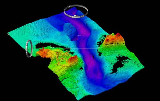
3 Surveys Multi-beam Echo Sounder (MBES)


4 Surveys Example of MBES Surveys: HMS Scott Tsunami Data
5 Why use ALB? In coastal regions, boat operations suffer from: reduced swathe width slow progress dangerous waters dependence on Mother ship high cost The advantages of ALB are: fixed swathe width minimum presence on ground rapid progress seamless data from sea to land low cost

6 Why use ALB? Land Topography and Sea Bathymetry collected as one database, at the same time
7 Why use ALB?

8 Why use ALB?
9 Why use ALB? Topo LiDAR Overcoming The White Ribbon Bathy/Topo LiDAR Shallow MBES Deep MBES Bathy/Topo LiDAR overlaps both ways
10 Why use ALB? No. of commercial systems in operation Data richness (points per 2x2 m area) Accuracy vertical Discrimination horizontal IHO Order achievable in survey Depth range for surveys Cost per 1km 2 of survey Speed - time taken to survey 200km 2 MBES ALB * 2cm 10cm * 0.1 m 1 m * Special 1a * 20-10,000 m 0-50 m * $3,000 $1, days 1 day * *
 and Infra Red (1064nm) The green beam penetrates the water, whereas the IR")
11 How does ALB work? The depth of water and height of land is measured by laser pulses of two wavelengths: Green (532nm) and Infra Red (1064nm) The green beam penetrates the water, whereas the IR laser is reflected at the surface. The time difference between the green (bottom) and the IR (water surface) laser reflections is used to calculate the depth. 11


12 How does ALB work? The HawkEye IIB system is unique in its use of pixelated discrimination. The receivers are divided into : 4 sections for the Hydro receivers 8 sections for the Topo receivers The use of multi pixel technology allows improvements on: data density Contrast object detection object discrimination 12
13 How does ALB work? HEIIb Technical Specification Bathymetric data rate 4 khz Topographic data rate Scan Pattern Set Angle Pulse Rate, Topo Laser Pulse Rate, Hydro Laser 64 khz Elliptical 20 8k pulse/sec (8pixels per return) 1k pulse/sec (4pixels per return) Positioning and Navigation Integrated digital camera system Reflectivity Applanix POS AV 510 GPS/IMU ueye UI 2250 C/M value per pulse reflectivity

14 How does ALB work? Scan Pattern The laser beams are scanned in a pattern on the water surface. The scanning mirror compensates for pitch, roll and yaw, ensuring that the beams are transmitted ahead of the aircraft at an offnadir angle of 20 and scan left and right either side of the line of advance of the aircraft. The result is an evenly spaced pattern covering the seabed. 14

15 How does ALB work? Object identification Size 2x2 m y Height 1.5 m y Corresponds very well to multibeam data y Green dots = HawkEye y
 high order INS system and dual frequency GNSS Turns at the end of")
16 How does ALB work? Track plots The aircraft flies a series of straight lines, its position being recorded to within 5cm using an Applanix 510 (IMU 31) high order INS system and dual frequency GNSS Turns at the end of the lines are tightly controlled to minimise nonsurvey time. Aircraft sortie times are ~ 4 5 hours. If possible, two sorties per day are scheduled. Broadhaven and Blacksod Bays March 5th 10th 2010


17 How does ALB work? Aircraft Small Local Photogrammetry hatch 50A, 24V dc 17

 Clear water (3 x")
18 Where can ALB be used? Land sea interface Shallow water (<50m depth) Clear water (3 x Secchi disc depth)

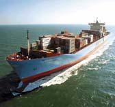
19 Where can ALB be used? Flood protection agencies Navies turbidity Inland Waterway users Merchant Shipping Archipelagos Fishermen

20 Where can ALB be used? Flood protection agencies Navies turbidity turbidity Inland Waterway users Merchant Shipping Archipelagos Fishermen

21 Where can ALB be used? Flood protection agencies Navies turbidity turbidity turbidity Inland Waterway users Merchant Shipping Archipelagos Fishermen

22 Where can ALB be used? Flood protection agencies Navies turbidity turbidity turbidity Inland Waterway users Merchant Shipping Archipelagos Fishermen

23 Where can ALB be used? Sweden New England Ireland Brittany Denmark Languedoc Malta Bahamas Red Sea Gulf Taiwan Maldives Tonga Port Phillip Pelydryn Surveys


24 Who can it be used for? National Hydrographic Offices Oil, Gas, Energy Companies Environmental Agencies Chart Companies UNCLOS
25 Pelydryn Surveys TREGOR DEMO.exe


26 Pelydryn Surveys Ireland


27 Pelydryn Surveys Ireland


28 Pelydryn Surveys Ireland

29 Pelydryn Surveys Multibeam Sweden

30 Pelydryn Surveys HawkEye II Sweden

31 Pelydryn Surveys France 31

32 Pelydryn Surveys France

33 Pelydryn Surveys New England

34 Pelydryn Surveys New England

35 Pelydryn Surveys New England

36 Pelydryn Surveys Reflectance processing New England

37 Pelydryn Surveys Reflectance processing New England

38 Pelydryn Surveys Reflectance processing New England

39 Pelydryn Surveys Tonga

40 Pelydryn Surveys Tonga

41 Pelydryn Surveys Maldives


42 Pelydryn Surveys Maldives


43 Pelydryn Surveys Maldives


44 Pelydryn Surveys Maldives
45 Pelydryn North America Central America South America Europe Middle East Indian Ocean Africa Far East Australasia China Russia Improved technology: HE3 MBES
46 Pelydryn Survey Planning Survey Management Data Collection Ship borne sonar Air borne lidar Data Processing Product delivery
47 Pelydryn Pelydryn Ltd provides a complete survey service using world leading airborne lidar and ship borne sonar equipment to meet the growing global demand for coastal & shallow water hydrographic & topographic data
48
USES & APPLICATIONS OF AIRBORNE LIDAR BATHYMETRY. Darren Stephenson - Fugro, 5 September 2017, Queensland Coastal Conference, Airlie Beach.
 USES & APPLICATIONS OF AIRBORNE LIDAR BATHYMETRY Darren Stephenson - Fugro, 5 September 2017, Queensland Coastal Conference, Airlie Beach. Overview of Fugro s Hydrographic Surveying Services Fugro: 10,500
Fugro Pelagos, Inc. Expertise and Experience in Hydrographic Surveying with Focus on High Latitudes
 HCA13-07.2A Fugro Pelagos, Inc. Expertise and Experience in Hydrographic Surveying with Focus on High Latitudes Don Ventura 4 December 2013 Company Profile Fugro provides the people, equipment, expertise
Test of bathymetric LiDAR in Denmark
 Test of bathymetric LiDAR in Denmark Date: 28. September 2012 Author: Andrew Flatman, Thomas Knudsen & Rune Carbuhn Andersen (all KMS) www.blast-project.eu 1 Table of Contents Introduction... 3 Context...
United Nations Development Program MACHC 2017 Hydrographic Awareness November 2017 Cuba
 Bathymetric Measurements of the Rio Indio, Panama, Province of Colón United Nations Development Program MACHC 2017 Hydrographic Awareness November 2017 Cuba Overview Funding Organizations and Project Framework
Frank Steinbacher 1. aerial (approx. < 10 cm/pixel) waterbody and foreland survey.
 waterbody and foreland survey.") Frank Steinbacher 1 Combining novel and traditional survey technologies in water engineering: Airborne Hydromapping and sonar data of the Rhine River at Rheinfelden, Germany & Switzerland Frank Steinbacher,
Frank Steinbacher 1 Combining novel and traditional survey technologies in water engineering: Airborne Hydromapping and sonar data of the Rhine River at Rheinfelden, Germany & Switzerland Frank Steinbacher,
NATIONAL REPORT OF BANGLADESH
 NATIONAL REPORT OF BANGLADESH 14 TH NORTH INDIAN OCEAN HYDROGRAPHIC COMMISSION (NIOHC) CONFERENCE Bangkok, Thailand 26-28 February 2014 1 National Report of Bangladesh 1. Hydrographic Office/ Services
New techniques in capturing and modelling of morphological data
 Schleswig-Holstein. Der echte Norden. Coastal protection New techniques in capturing and modelling of morphological data Contents Coastal protection Previous kind of survey LIDAR bathymetry Principle and
INNOVATION & EXPERTISE
 01 INNOVATION & EXPERTISE Based on expertise gained from operations in several countries, MARINE TECH engineers use this feedback to design an efficient, reliable and robust solution: the RSV - Remote
Use of a Multibeam Echosounder (Sonar) for Critical Infrastructure Assessments during the 2011 Missouri River Flood
 for Critical Infrastructure Assessments during the 2011 Missouri River Flood") Use of a Multibeam Echosounder (Sonar) for Critical Infrastructure Assessments during the 2011 Missouri River Flood Richard C. Wilson P.E. Associate Director, USGS Nebraska Water Science Center Thailand
Use of a Multibeam Echosounder (Sonar) for Critical Infrastructure Assessments during the 2011 Missouri River Flood Richard C. Wilson P.E. Associate Director, USGS Nebraska Water Science Center Thailand
Acoustic versus Optic remote sensing in hydrography
 6 th Workshop Seabed Acoustics, Rostock, November 14/15, 2013 P01-1 Acoustic versus Optic remote sensing in hydrography Thomas Dehling Federal Maritime and Hydrographic Agency (BSH) Germany Contact Address
National Report of Finland
 National Report of Finland (15 April 2008) Executive Summary This Report gives an overview of the main activities of the Finnish Hydrographic Office since the last NHC/51 meeting. The main issues are:
Hydraulics and Drones: Observations of water level, bathymetry and water velocity from UAVs
 Hydraulics and Drones: Observations of water level, bathymetry and water velocity from UAVs Filippo Bandini PostDoctoral researcher DTU Environment fban@env.dtu.dk Hydraulic variables Hydraulic observations
Priority Setting Process For Hydrographic Surveys Page 1 of Parameter 1 - Quality of Survey Data Currently Available... 9
 Priority Setting Process For Hydrographic Surveys Page 1 of 25 Contents 1 Scope... 4 2 Related Standards... 4 Symbols (& Abbreviated Terms)... 5 4 Prioritising Parameters... 6 5 Weighting... 7 6 Issuing
Reducing the Cost of Developing and Operating Offshore Wind Farms with Autonomous Surface Vessels. James Cowles, ASV Ltd Terry Sloane, Planet Ocean
 Reducing the Cost of Developing and Operating Offshore Wind Farms with Autonomous Surface Vessels James Cowles, ASV Ltd Terry Sloane, Planet Ocean Reducing the Cost of Developing and Operating Offshore
Intelligent Exploitation of the Blue Economy - A Hydrographic Perspective
 Intelligent Exploitation of the Blue Economy - A Hydrographic Perspective Don Ventura Fugro Pelagos, Inc. Meso-American and Caribbean Hydrographic Commission, St. Maarten December 2013 Introduction Blue
GOALS 1 1. PLANKTON SAMPLING 2 1A. ZOOPLANKTON VERTICAL NET TOW 3 1B. PHYTOPLANKTON NET TOW 4 1C. PHOTOSYNTHESIS & RESPIRATION: BOTTLE INCUBATIONS.
 GOALS 1 1. PLANKTON SAMPLING 2 1A. ZOOPLANKTON VERTICAL NET TOW 3 1B. PHYTOPLANKTON NET TOW 4 1C. PHOTOSYNTHESIS & RESPIRATION: BOTTLE INCUBATIONS. 5 2. WATER COLUMN STRUCTURE 7 3. MORPHOLOGIC FEATURE
Teledyne RESON SeaBat T20-P. The new SeaBat T20-P Designed with a deeper understanding of your needs
 The new SeaBat T20-P Designed with a deeper understanding of your needs 2 Teledyne RESON SeaBat T20-P A vision of quality and performance For almost 30 years, Reson has been the world s most trusted provider
The unmanned surface vehicle used in hydrographic surveying
 The unmanned surface vehicle used in hydrographic surveying Adin Li, Stefan Wei Key words: hydrographic; marine; channel; USV; SUMMARY Hydrographic survey is essential and widely welcomed in the world
Intelligent Exploitation of the Blue Economy - A Hydrographic Perspective
 Intelligent Exploitation of the Blue Economy - A Hydrographic Perspective Don Ventura Fugro Pelagos, Inc. IHO-FIG Blue Economy Seminar, Ocean Business, Southampton, 14 April 2015 Introduction Blue Economy
National Report of Finland
 National Report of Executive Summary This Report highlights the main activities and achievements of the Finnish Hydrographic Office since NHC 62 th Conference in April 2018. - Finnish Hydrographic Office
S.A.M.Azmy Head Environmental Studies Division National Aquatic Resources Research and Development Agency (NARA) Crow Island, Colombo 15
 Crow Island, Colombo 15") S.A.M.Azmy Head Environmental Studies Division National Aquatic Resources Research and Development Agency (NARA) Crow Island, Colombo 15 August 2009 IPS-Seminar on Policy Issues of Climate Change National
S.A.M.Azmy Head Environmental Studies Division National Aquatic Resources Research and Development Agency (NARA) Crow Island, Colombo 15 August 2009 IPS-Seminar on Policy Issues of Climate Change National
Application for Consent to conduct Marine Scientific Research. 1.2 Sponsoring Institution(s): Marine Institute Rinville, Oranmore, Co Galway, Ireland
: Marine Institute Rinville, Oranmore, Co Galway, Ireland") Application for Consent to conduct Marine Scientific Research Date: 23/01/2018 1. General Information 1.1 Cruise name and/or number: CV18015, CV18021, and CV18023 1.2 Sponsoring Institution(s): Address:
Application for Consent to conduct Marine Scientific Research Date: 23/01/2018 1. General Information 1.1 Cruise name and/or number: CV18015, CV18021, and CV18023 1.2 Sponsoring Institution(s): Address:
BANGLADESH NATIONAL HYDROGRAPHIC REPORT
 BANGLADESH NATIONAL HYDROGRAPHIC REPORT FOR THE 9 TH NIOHC MEETING SEYCHELLES 25 TH 26 TH FEBRUARY 2009 1 CONTENTS 1. Hydrographic Office 2. Surveys 3. New Charts & Updates 4. New Publications & Updates
Questionnaire to BSHC Member States on their implementation status of the transition to a Harmonised Vertical Reference, Baltic Sea Chart Datum 2000.
 Questionnaire to BSHC Member States on their implementation status of the transition to a Harmonised Vertical Reference, Baltic Sea Chart Datum 2000. Please return to Thomas Hammarklint by email (thomas.hammarklint@sjofartsverket.se)
Teledyne RESON SeaBat T20-P. The new SeaBat T20-P Designed with a deeper understanding of your needs
 The new SeaBat T20-P Designed with a deeper understanding of your needs 2 Teledyne RESON SeaBat T20-P A vision of quality and performance For almost 30 years, RESON has been the world s most trusted provider
The FPS Economy and the RV Belgica: 15 years of successful collaboration! To be continued?
 The FPS Economy and the RV Belgica: 15 years of successful collaboration! To be continued? Jean-Marc Delporte President of the Executive Committee FPS Economy, SMEs, Self-employed and Energy E64400 6-20c
Request for Information RFI THE CHESAPEAKE BAY BRIDGE AND TUNNEL DISTRICT
 Request for Information April 8, 2016 RFI THE CHESAPEAKE BAY BRIDGE AND TUNNEL DISTRICT Chesapeake Bay Bridge and Tunnel District 32386 Lankford Highway Cape Charles, VA 23310 Request for Information:
HIGH RESOLUTION AIRBORNE SHALLOW WATER MAPPING
 HIGH RESOLUTION AIRBORNE SHALLOW WATER MAPPING F. Steinbacher a, *, M. Pfennigbauer b, M. Aufleger a, A. Ullrich b a Unit of Hydraulic Engineering, University of Innsbruck, Technikerstr. 13a, 6020 Innsbruck,
Jim Nickels Marine Scientist Urban Coast Institute Monmouth University May 25, NJ Water Monitoring Council Meeting
 Jim Nickels Marine Scientist Urban Coast Institute Monmouth University May 25, 2011 NJ Water Monitoring Council Meeting Program and Research Areas Real Time Water Quality Monitoring Network Shrewsbury
PRODUCT INFORMATION PLB PRECISE LOCALIZATION OF PARTS IN BINS. Robot guidance systems
 PRODUCT INFORMATION PLB PRECISE LOCALIZATION OF PARTS IN BINS Robot guidance systems PLB ROBOT GUIDANCE SYSTEMS PROCESS OPTIMIZATION AND COST SAVINGS FOR AUTOMATED PARTS HANDLING IN PRODUCTION Robot-automated
DFO-Science Canadian Hydrographic Service (CHS) Mariners Workshop 2017 January 25-26, 2017 Vancouver, BC, Canada Denis Hains, Director General CHS &
 Mariners Workshop 2017 January 25-26, 2017 Vancouver, BC, Canada Denis Hains, Director General CHS &") DFO-Science Canadian Hydrographic Service (CHS) Mariners Workshop 2017 January 25-26, 2017 Vancouver, BC, Canada Denis Hains, Director General CHS & Hydrographer General of Canada Overview Canadian Hydrographic
DFO-Science Canadian Hydrographic Service (CHS) Mariners Workshop 2017 January 25-26, 2017 Vancouver, BC, Canada Denis Hains, Director General CHS & Hydrographer General of Canada Overview Canadian Hydrographic
Crowdsourced Bathymetry
 Crowdsourced Bathymetry Utilising the Crowd to obtain high quality depth data By Christopher Baxter Project Advisor: Mr Gwyn Jones Project Aim Can Crowdsourced Bathymetry (CSB) data obtained from non-survey
THE IMPORTANCE OF HYDROGRAPHIC SURVEYING IN THE DEVELOPMENT OF A WATER/LAKE TRANSPORTATION SYSTEM IN GHANA
 THE IMPORTANCE OF HYDROGRAPHIC SURVEYING IN THE DEVELOPMENT OF A WATER/LAKE TRANSPORTATION SYSTEM IN GHANA By Surv. Isaac Larbie, GHANA Geomatic Engineer, Survey and Mapping Division E-mail: ikelarbie@gmail.com
Valuing Strategic Coastal Monitoring Data
 Valuing Strategic Coastal Monitoring Data Stewart Rowe Principal Coastal Officer Scarborough Borough Council North East Coastal Group Chairman Telford 28 th of March 2017 Simply put coastal monitoring
PAKISTAN NAVY HYDROGRAPHIC DEPARTMENT
 PAKISTAN NATIONAL REPORT 6th MEETING ROPME SEA AREA HYDROGRAPHIC COMMISSION (RSAHC) Abu Dhabi, UAE 09-11 February 2015 PAKISTAN NAVY HYDROGRAPHIC DEPARTMENT HYDROGRAPHIC DEPARTMENT OF PAKISTAN (NATIONAL
STATUS QUO REPORT ON ENC ACTIVITIES
 NETWORK OF DANUBE WATERWAY ADMINISTRATIONS South-East European Transnational Cooperation Programme STATUS QUO REPORT ON ENC ACTIVITIES RO - ACN Document ID: Activity: 5.2 Author / Project Partner: Date:
The new SeaBat T20-P Designed with a deeper understanding of your needs
 The new SeaBat T20-P Designed with a deeper understanding of your needs 2 A vision of quality and performance For almost 30 years, RESON has been the world s most trusted provider of advanced multibeam
LiDAR Data capture with sensor SPL100 in the Region of Navarra
 Víctor García, Tracasa LiDAR Data capture with sensor SPL100 in the Region of Navarra Workshop: Use of algorithms on big DEM s Tønsberg, 4 th April 2018 Company Presentation - Tracasa TRACASA is a public
IHO Capacity Building: Industry Contribution
 IHO Capacity Building: Industry Contribution Paul Cooper CARIS USA Don Ventura Fugro Pelagos Inc. 8 October 2014 Contents Introduction Aim Addressing Resource Limitations Caveats: Some Assumptions and
Onshore Wind. Optimisation & Cost Reduction. All Energy 2015
 Onshore Wind Optimisation & Cost Reduction All Energy 2015 Our network of local offices Global track record We have consulted on over 110GW of renewable energy in over 70 countries covering both project
PROPOSED 400kV SUBSTATION AND EASTERN HVDC LINK
 PROPOSED 400kV SUBSTATION AND EASTERN HVDC LINK BACKGROUND The European Union has set a target that 15% of Europe s energy requirements shall be met from renewable resources by 2020. The UK Government
National Report of Finland
 National Report of Executive Summary This Report highlights the main activities and achievements of the Finnish Hydrographic Office since NHC 61 th Conference in March 2017. - Hydrographic surveys have
Monotoring of instream habitats with focus on morphological dynamics based on Airborne Laser Bathymetry
 Monotoring of instream habitats with focus on morphological dynamics based on Airborne Laser Bathymetry Gottfried Mandlburger, Christoph Hauer, and Martin Wieser gottfried.mandlburger[martin.wieser]@geo.tuwien.ac.at
Presented at the FIG Congress 2018, May 6-11, 2018 in Istanbul, Turkey. USV, A Smart Way To Survey
 Presented at the FIG Congress 2018, May 6-11, 2018 in Istanbul, Turkey USV, A Smart Way To Survey Challenges Easy to be stranded Danger ous Limitation Inefficient and Inaccurate Cliff area Dams and reservoirs
Field Data Collection at Coastal Inlets
 Field Data Collection at Coastal Inlets by Thad C. Pratt, Timothy L. Fagerburg, and Darla C. McVan PURPOSE: The Coastal Engineering Technical Note (CETN) described herein provides overview guidance on
An Introduction to Near Real Time Data Processing
 An Introduction to Near Real Time Data Processing Presented by Andy Hoggarth, CARIS HYDRO 2015 23-25 NOV CAPE TOWN Scope Introduction The current autonomous platform market The Operational Requirement
Process Automation for Efficient Ocean Mapping
 Process Automation for Efficient Ocean Mapping OCEANS 18 MTS/IEEE Kobe / Techno Ocean 2018 May 29 to 31, 2018 Presented by: Matt Holland, Sales Manager Asia / Pacific, Teledyne CARIS Content SEA KIT to
International Business Parcels Rate card
 International Business Parcels Rate card Tracked Effective from 3rd July 2017 Standard Tracked Tracked Signed Standard 1 Contents International Business Parcels services... 3 International Tracked... 4
THE NUMBERS STEPHEN TAYLOR
 THE NUMBERS STEPHEN TAYLOR Millions of tonnes UK PORT TRAFFIC LONG TERM 600 500 One-port 5% Coastwise 8% Oneport 7% Coastwi se 27% Exports 15% Imports 51% 400 300 200 100 0 1975 1977 1979 1981 1983 1985
DESCRIPTION OF MARITIME ACTIVITIES
 INTRODUCTION 1. Regional Hydrographic Commission Involvement Angola is not an IHO member, but is an associate member of the Southern Africa and Islands Hydrographic Commission (SAIHC). Angola has been
BISSO MARINE ADVANCED BURIAL & BACKFILL PLOUGH
 BISSO MARINE APR 2016 PIPELINE PLOUGH BURIAL & BACKFILL Throughout most US Territorial Waters, US Federal and State Governmental regulations require marine, offshore and subsea pipelines to be buried.
The Port ENC part of e-navigation, RIS, VTS, AIS Results of the integrated EU research project EFFORTS
 The Port ENC part of e-navigation, RIS, VTS, AIS Results of the integrated EU research project EFFORTS September 13-16, 2011, New Orleans, Louisiana, USA The integrated EU research project EFFORTS (May
Smart Data for Smart Infrastructure Information. James van Rens Strategic Advisor Riegl Group January 2019
 Smart Data for Smart Infrastructure Information James van Rens Strategic Advisor Riegl Group January 2019 Dr. Johannes Riegl Smart Cities and Lidar The explosive growth of cities is a tremendous challenge
UNIVERSITY OF CAMBRIDGE INTERNATIONAL EXAMINATIONS International General Certificate of Secondary Education
 UNIVERSITY OF CAMBRIDGE INTERNATIONAL EXAMINATIONS International General Certificate of Secondary Education *4637936083* GEOGRAPHY 0460/11 Paper 1 October/November 2009 Additional Materials: Answer Booklet/Paper
THE UNITED REPUBLIC OF TANZANIA
 SAIHC9-5.3M THE UNITED REPUBLIC OF TANZANIA NATIONAL REPORT TO THE 9 TH SOUTHERN AFRICAN AND ISLANDS HYDROGRAPHIC COMMISSION MAURITIUS 18 TH 19 TH SEPTEMBER, 2012 1. GENERAL 2 The United Republic of Tanzania
BLAST INTERREG IV North Sea Region Program. Work Package 3 Developing the Marine & Coastal Reference Base. Summary Report
 BLAST INTERREG IV North Sea Region Program Work Package 3 Developing the Marine & Coastal Reference Base Summary Report Date: 20 th August 2012 Author: Rust, A M, Version R1r0 www.blast-project.eu 1 Authors
PRODUCT INFORMATION PLR 3D LOCALIZATION OF PARTS IN CARRIERS. Robot guidance systems
 PRODUCT INFORMATION PLR 3D LOCALIZATION OF PARTS IN CARRIERS Robot guidance systems PLR ROBOT GUIDANCE SYSTEMS COST-EFFECTIVE, PRECISE ROBOT GUIDANCE Part handling is one of the most important applications
Airborne and Terrestrial Laser Scanning in Forestry
 Airborne and Terrestrial Laser Scanning in Forestry Géza Király 1, Gábor Brolly 1 1 University of West Hungary Faculty of Forestry Department of Surveying and Remote Sensing H-9400 SOPRON, Bajcsy-Zs u.
The Economic Benefits of Hydrography and Ocean Mapping
 The Economic Benefits of Hydrography and Ocean Mapping FIG XXIV Congress, Sydney Australia, 2010 Commission 4: Hydrography Gordon Johnston Venture Geomatics Limited gordon.johnston1@orange.net Overview
MARITIEME AUTORITEIT SURINAME
 MARITIEME AUTORITEIT SURINAME National Report 12th MEETING OF THE MESO AMERICAN AND CARIBBEAN SEA HYDROGRAPHIC COMMISSION (MACHC) 5 th -9 th December 2011 Basseterre, St. Kitts Content 1. The Maritime
Maximizing the Value of Autonomous Surveys
 Maximizing the Value of Autonomous Surveys IHO HSSC-7 Open Session 12 November 2015 Busan, Republic Of Korea Presented by: Matt Holland, CARIS Content Introduction Survey platforms and force multiplication
Socio-economic Impact of Sethusamudram Project
 MPRA Munich Personal RePEc Archive Socio-economic Impact of Sethusamudram Project Srinivasan Kannan 2007 Online at http://mpra.ub.uni-muenchen.de/13965/ MPRA Paper No. 13965, posted 11. March 2009 15:24
Next Gen ERP for Freight and Logistics
 INCREASE SALES Automation of the sales life cycle with insights HIGHER PROFIT Unparalleled features to grow your business ENHANCE EFFICIENCY Streamline core processes more effectively HAPPY CUSTOMERS Customer
Hydrographic Society Southern Region - Meeting November 10th. The Port of Southampton
 Hydrographic Society Southern Region - Meeting November 10th Billy Johnson, ABP Southampton: Experiences with a new multibeam system Recent experience of installing and commissioning a Reson 7101 multibeam
THE EFFECTS OF FOOTPRINT SIZE AND SAMPLING DENSITY IN AIRBORNE LASER SCANNING TO EXTRACT INDIVIDUAL TREES IN MOUNTAINOUS TERRAIN
 THE EFFECTS OF FOOTPRINT SIZE AND SAMPLING DENSITY IN AIRBORNE LASER SCANNING TO EXTRACT INDIVIDUAL TREES IN MOUNTAINOUS TERRAIN Y. Hirata Shikoku Research Center, Forestry and Forest Products Research
II. Methodology for consideration of the application by the Legal and Technical Commission
 International Seabed Authority Council Distr.: General 7 August 2017 Original: English Twenty-third session Kingston, 7-18 August 2017 Report and recommendations of the Legal and Technical Commission to
FRENCH NATIONAL REPORT TO THE 5 TH MEETING OF THE ROPME HYDROGRAPHIC COMMISSION
 SERVICE HYDROGRAPHIQUE ET OCEANOGRAPHIQUE DE LA MARINE DIRECTION DES MISSIONS INSTITUTIONNELLES ET DES RELATIONS INTERNATIONALES Dossier suivi par IETA Eric Langlois Head of the external relations division
IMPROVED ACTIVE SONAR TACTICAL SUPPORT BY THROUGH-THE-SENSOR REA
 IMPROVED ACTIVE SONAR TACTICAL SUPPORT BY THROUGH-THE-SENSOR REA L. Abrahamsson a, B.L. Andersson a, S. Ivansson a, J. Pihl a, M. Ainslie e, F. Benders e, B. Chalindar b, M. Colin e, X. Cristol b, J. Dybedal
Unmanned Surface Vehicle (USV) Hydrographic Surveys by TerraSond Successful Implementation & Benefits
 Hydrographic Surveys by TerraSond Successful Implementation & Benefits") Unmanned Surface Vehicle (USV) Hydrographic Surveys by TerraSond Successful Implementation & Benefits Shallow Survey 2018 October 01-03 St. John's, NL A1C 6K4 Canada Stephen Forbes Consultant Hydrographer
Unmanned Surface Vehicle (USV) Hydrographic Surveys by TerraSond Successful Implementation & Benefits Shallow Survey 2018 October 01-03 St. John's, NL A1C 6K4 Canada Stephen Forbes Consultant Hydrographer
Mapping the Gaps Through Process Automation Map the Gaps A GEBCO Symposium On Bathymetry 15 November 2017 Busan, South Korea
 Mapping the Gaps Through Process Automation Map the Gaps A GEBCO Symposium On Bathymetry 15 November 2017 Busan, South Korea Presented By: Matt Holland, Deputy Marketing and Sales Manager Teledyne CARIS
Enhancing Data Resolution to Improve Maritime Safety
 Enhancing Data Resolution to Improve Maritime Safety Pacific Northwest Waterways Association 2014 Annual Convention October 15 17 th, Vancouver, WA Jon Dasler, PE, PLS, CH Director of Marine Services,
Dredging & Spoil Management Plan - Dampier. Dredging and Spoil Management Plan - Dampier. Issued Date: 28/12/2012 Rev No: 0 Page: 1 of 24
 Dredging & Spoil Issued Date: 28/12/2012 Rev No: 0 Page: 1 of 24 Dredging & Spoil 1. INTRODUCTION... 3 2. SCOPE... 3 3. TECHNICAL ADVISORY AND CONSULTATIVE COMMITTEE... 5 4. DRGING APPROVAL PROCESS...
Unmanned systems for offshore areas: what is available and what is needed. by William Koski
 Unmanned systems for offshore areas: what is available and what is needed by William Koski The Need Offshore areas are sometimes hazardous to conduct aerial and water based studies because: weather can
GEBCO Data Flow Workshop Boulder, CO, USA
 GEBCO Data Flow Workshop Boulder, CO, USA David H. Fabre Naval Oceanographic Office Bathymetry Databases 9 Mar 2011 We collect our own data, have agreements, and data mine (more & more) Collection Platforms
Multimodal Transport. Key Challenges Domestic & International. Arunendra Kumar Former Chairman, Railway Board
 Multimodal Transport Key Challenges Domestic & International Arunendra Kumar Former Chairman, Railway Board 1. CONTAINER Container has changed the world It has become ICON of Globalism It has enabled -
Legal aspects and liability issues concerning autonomous shipping
 Legal aspects and liability issues concerning autonomous shipping E-Navigation underway 2018 24th 26th January 2018 Matti K Eronen, LL.M. Legal Councel The presentation Conclusions 2 About automatization
REAL-TIME CONCENTRATION AND GRAIN SIZE MEASUREMENT OF SUSPENDED SEDIMENT USING MULTI-FREQUENCY BACKSCATTERING TECHNIQUES ABSTRACT
 REAL-TIME CONCENTRATION AND GRAIN SIZE MEASUREMENT OF SUSPENDED SEDIMENT USING MULTI-FREQUENCY BACKSCATTERING TECHNIQUES T. HIES 1, H. H. NGUYEN 2, J. SKRIPALLE 3 1,2 HydroVision Asia Pte Ltd, 1 Cleantech
Your challenge, our project logistics solutions for the Retail industry.
 Your challenge, our project logistics solutions for the Retail industry. Vertical Market Retail Solutions Photo: thinkstock.com Vertical Market Retail Best connections to the industry. DB Schenker stands
From Applied Research to Application - Remote Sensing Products for Waterway Management
 From Applied Research to Application - Remote Sensing Products for Waterway Management Herbert Brockmann H. Brockmann, PhoWo 2017, Stuttgart 1 Agenda Introduction Relevant products Selected potential applications
Where the Ocean Meets Land. Coastal Engineering
 Where the Ocean Meets Land Coastal Engineering Photo credit : Rio Tinto Alcan Our Expertise MARINAS AND HARBOURS Design and repair of breakwaters Sedimentation and dredging studies Navigation guidelines
Borehole Condition Assessment
 Borehole Condition Assessment The condition of a borehole is paramount to its on going performance. Checks on newly drilled boreholes ensure that design and specification have been met and allow benchmark
Dry and Liquefied Gas to European Markets
 Dry and Liquefied Gas to European Markets Competing or Complementary? Graham Bennett Outline Introduction Supply/Demand changes affecting the gas market Innovations impacting gas import/export options
Kardex Remstar Horizontal An efficient solution for fast storage and picking
 Material Handling Solutions Kardex Remstar Horizontal An efficient solution for fast storage and picking Save time through rapid, direct and reliable access The Kardex Remstar Horizontal is designed for
NETWORK OF DANUBE WATERWAY ADMINISTRATIONS South-East European Transnational Cooperation Programme TITLE OF DOCUMENT SUBTITLE
 NETWORK OF DANUBE WATERWAY ADMINISTRATIONS South-East European Transnational Cooperation Programme TITLE OF DOCUMENT SUBTITLE Document ID: Output 4.11 Activity: 4.3 Preparation of national strategy plans
PRIMAR RENC Model. REGIONAL ENC/ECDIS SEMINAR Rio, Brazil, 5-6 November Odd Breivik, NHS. Operated by the Norwegian Hydrographic Service
 PRIMAR RENC Model REGIONAL ENC/ECDIS SEMINAR Rio, Brazil, 5-6 November 2008 Odd Breivik, NHS PRIMAR RENC Regional ENC Coordinating Centre RENC concept is at the core of the WEND Principles (World Wide
Higher National Unit specification: general information
 Higher National Unit specification: general information Unit code: H1FC 35 Superclass: ZF Publication date: April 2012 Source: Scottish Qualifications Authority Version: 01 Unit purpose The purpose of
...because safety matters. Admiralty Digital Publications
 Admiralty Digital Publications Admiralty Digital Publications What are Admiralty Digital Publications? Admiralty Digital Publications (ADP) are a collection of digital versions of the UKHO s industry leading
Ocean Market Update. February 9, 2012
 Ocean Market Update February 9, 2012 Agenda 2012/2012 Market Trends Status of EB TP Capacity Changes In Alliances Conclusions Photo placeholder 2 Global box container trade growth 2011 (Oct YTD): 7.1%
Policy Research Corporation
 Policy Research Corporation SOUND SOLUTIONS BASED ON SCIENTIFIC RESEARCH The role of Maritime Clusters to enhance the strength and development of maritime sectors Country report Lithuania INTRODUCTION
Airborne Laser Scanning (ALS) for forestry applications
 for forestry applications") Airborne Laser Scanning (ALS) for forestry applications International School on Lidar Technology 2008 IIT Kanpur, India Norbert Pfeifer + I.P.F.-Team http://www.ipf.tuwien.ac.at/ Christian Doppler Laboratory
Airborne Laser Scanning (ALS) for forestry applications International School on Lidar Technology 2008 IIT Kanpur, India Norbert Pfeifer + I.P.F.-Team http://www.ipf.tuwien.ac.at/ Christian Doppler Laboratory
SNG High Performances Green Microchip Series
 SNG High Performances Green Microchip Series Key features Repetition rate up to 70kHz Ultrashort pulses down to 500ps Multi-kW peak power Excellent beam quality, M²
SLS-process monitoring and temperature control
 SLS-process monitoring and temperature control Yu. Chivel 1, M. Doubenskaia 2 1 Institute of Molecular & Atomic Physics NAS Belarus 68 Nezavisimosti av., 220072, Minsk, Belarus 2 Ecole Nationale d Ingénieurs
Three-Dimensional Silicon Photonic Lattice
 Three-Dimensional Silicon Photonic Lattice J.G. Fleming and Shawn-Yu Lin Sandia National Laboratory, MS 084, P.O. Box 5800, Albuquerque NM, 8785 Phone (505) 844 958 Fax (505) 844 299, e-mail fleminjg@sandia.gov
PRODUCT INFORMATION PLB PRECISE LOCALIZATION OF PARTS IN BINS. Robot guidance systems
 PRODUCT INFORMATION PLB PRECISE LOCALIZATION OF PARTS IN BINS Robot guidance systems PLB ROBOT GUIDANCE SYSTEMS PROCESS OPTIMIZATION AND COST SAVINGS FOR AUTOMATED PARTS HANDLING IN PRODUCTION Robot-automated
a brand of Finnish Transport Agency Guidelines for the inspection of underwater engineering structures + case study
 a brand of Finnish Transport Agency Guidelines for the inspection of underwater engineering structures + case study Nord PIANC 27.-28.9.2017 Stockholm Kari Pohjola WHO? Work was ordered by Finnish Transport
ASSESSMENT OF A LASER SCANNER ON AGRICULTURAL MACHINERY
 ASSESSMENT OF A LASER SCANNER ON AGRICULTURAL MACHINERY Detlef Ehlert, Michael Heisig, Rolf Adamek Leibniz-Institute for Agricultural Engineering Potsdam-Bornim, Germany dehlert@atb-potsdam.de, mheisig@atb-potsdam.de,
The Port ENC a proposal for a new port related ENC standard. The EFFORTS project
 The Port ENC a proposal for a new port related ENC standard Combined 20 th TSMAD and 2nd DIPWG Meeting 3 to 7 May 2010 (Rostock, Germany) The EFFORTS project A general remark: Port ECDIS was the EFFORTS
And thanks to the support of the Government of Hong Kong Special Administrative Region (HKSAR) to the work of the IFPSM and IPSHK!
 to the work of the IFPSM and IPSHK!") Keynote Speech: The Status and Trends of Global Purchasing Development and the Development of the Belt and Road Speaker: Mr. He Liming President of International Federation of Purchasing and Supply Management
Keynote Speech: The Status and Trends of Global Purchasing Development and the Development of the Belt and Road Speaker: Mr. He Liming President of International Federation of Purchasing and Supply Management
NORDIC HYDROGRAPHIC COMMISSION (NHC)
") IRCC9-06A NORDIC HYDROGRAPHIC COMMISSION (NHC) NHC report to IRCC9 Paramaribo, Suriname 12-14 June 2017 1. Chair: Mr Patrik Wiberg Vice-Chair: Mrs Annika Kindeberg 2. Membership Members: Denmark, Finland,
IRCC9-06A NORDIC HYDROGRAPHIC COMMISSION (NHC) NHC report to IRCC9 Paramaribo, Suriname 12-14 June 2017 1. Chair: Mr Patrik Wiberg Vice-Chair: Mrs Annika Kindeberg 2. Membership Members: Denmark, Finland,