Use of a Multibeam Echosounder (Sonar) for Critical Infrastructure Assessments during the 2011 Missouri River Flood
|
|
|
- Elijah Cobb
- 5 years ago
- Views:
Transcription

1 Use of a Multibeam Echosounder (Sonar) for Critical Infrastructure Assessments during the 2011 Missouri River Flood Richard C. Wilson P.E. Associate Director, USGS Nebraska Water Science Center Thailand Pollution Control Department February 10, 2012
2

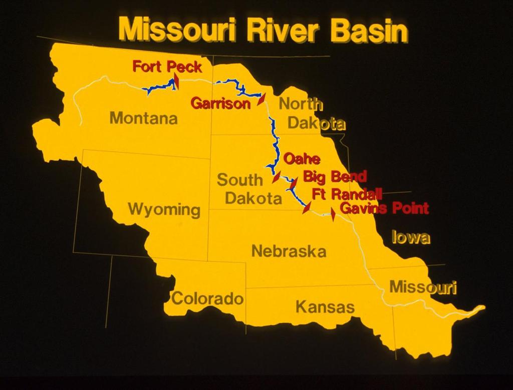
3 Fort Peck Dam

4 Fort Randall Dam

5 Missouri River - before

6 Missouri River - during
7

8 2011 Missouri River Flood June 2011 I-680 Bridge Looking east

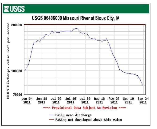
9 2011 Missouri River Flood Gavins Point Dam June ,000 cfs or 4,700 cms

10 2011 Flood Fort Calhoun Nuclear Power Plant July ,000 cfs or 5,805 cms

11 2011 Flood Blair Marina July ,000 cfs or 5,805 cms

12 2011 Flood South Sioux City July 24, ,000 cfs or 4,955 cms

13 2011 Flood South Sioux City July 24, ,000 cfs or 4,955 cms
14
15
16
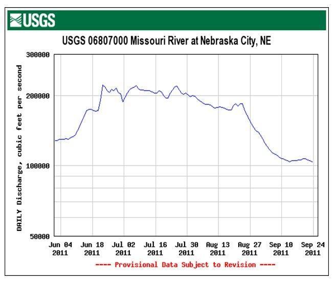
17 2011 Flood-USGS Role Daily discharge measurements from St. Louis to Montana Hydrographic surveying for infrastructure assessment and protection Served at Flood Command Center Near real-time hydraulic modeling Water-quality sampling Sediment sampling for sediment-transport analysis by physical sampling methods and multibeam echosounder (sonar) soundings: first time ever at these discharges Rapid deployment streamgages
18 2011 Flood-USGS Measuring Discharge Streamgages Real-time stage and discharge information Discharge measurements Stage-discharge ratings Record processing Missouri River gages at: Yankton, Maskell, Sioux City, Decatur, Blair, Omaha, Plattsmouth, NE City, and Rulo Information used by multiple agencies Critical to the flood fight, 150 discharge measurements

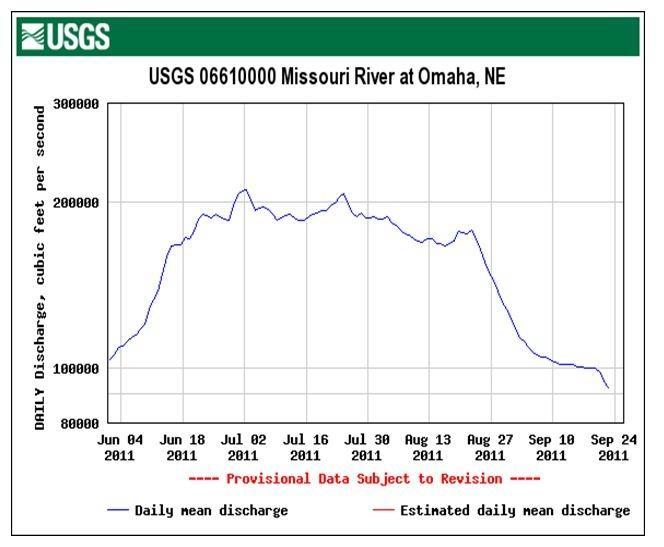
19 2011 Flood-Discharge Measurements Missouri River at Omaha, NE IA NE 984 ft Above Sea Level 1,266 ft. from Iowa Bank 938 ft July 1, 2011 Discharge: 207,000 cfs Gage Height: ft Max Depth: 46.2 ft Average Depth: 17.2 ft
20 Hydrographic Surveying - Purposes Assessments of lakes and reservoirs Navigation bathymetry maps Quantity measurements of dredged materials Inspections of dams, bridges, levees, and other infrastructure Data for hydrodynamic and sediment-transport models Habitat assessment Scour assessment
21 Bathymetric Map

22 Multibeam Echosounder (MBES) Hydrographic Surveying State of the art technology Maps the entire bed Accurate measurement Identifies deep holes, shallow areas, bed material, debris, structures, fish 22

 navigation system for")
23 Multibeam Echosounder (MBES) Reson Seabat MBES Sonar Swath width 130 degrees or 3.5-to-1 ratio 512 beams, equally spaced data points collected per ping 10 to 30 pings per second (US vs. DS) Depth from 0.5 to 150 meters RTK GPS and inertial measurement unit (IMU) navigation system for precise positioning Maps the entire river bed Nadar Beam 23


24 Reson 7125 Multibeam Echosounder Components Projector Array Receiver Array Sound Velocity Probe
25 Multibeam Patch Test Calibration Roll correction Pitch correction Yaw correction Nadar Beam

26 Multibeam Data Processing Data sets are large, typically 35 million points per bridge survey Dell Precision T7500 Intel Xeon Quad Core Processor 3.46 GHz 12GB DDR3 SDRAM, 1333MHz, 2 GeForce GTX Graphics Cards Software Navigation: HYSWEEP Data processing : Caris Data interpretation: ESRI
27 Accuracy of MBES Surveys Multiple factors Satellite configuration RTKGPS vs. DGPS Quality of the GPS benchmark Beam angle (degrades at larger angles) Motion correction - IMU Water depth Quality Control Bar check Repeat survey Speed of sound in water Compare to previous surveys

28 2011 Flood-Infrastructure Assessment and Protection USGS conducted multiple hydrographic sonar surveys, June December 2011 Bridge piers and abutments Transmission towers Intake structures River bed Side channels Levees Pipelines

29 Dangerous work Lack of access Submerged boat ramps Entry points: roads, ditches, anywhere Long travel times to the survey site High velocity flows Eroding banks Restricted use Corps of Engineers USGS Coast Guard Others 2011 Flood- Difficult Operations

30 2011 Flood- Bridge Scour Sioux City June 25


31 2011 Flood- Multibeam Survey Results 31
 Pier Failed Abutment")
32 2011 Flood-Multibeam Results Hwy-51 Flow Decatur Hwy 51 Overbank Flood Channel (New) Pier Failed Abutment

33 2011 Flood-Multibeam Results Hwy-51

34 2011 Flood-Multibeam Results Hwy-51 Bridge Abutment Failure Flow Revetment Pier Scour Hole
35 2011 Flood-Scour Hwy-51 Bridge

36 2011 Flood-Scour Hwy-370 Bridge Multibeam echosounder sonar USGS, NDOR, MODOT crews Overall 43 bridges surveyed from St. Louis to Montana
 July 19, 2011")
37 2011 Flood-Scour Hwy-2 NE City (depth in meters) July 19, ,000 cfs
38 2011 Flood-Yellowstone River Pipeline Rupture On July 1, 2011, an Exxon Mobil pipeline ruptured releasing an estimated 42,000 gallons of oil into the Yellowstone River near Laurel, Montana. The 12-inch line broke after flooding scoured the river bed and exposed the pipe, which had been buried just 5 feet deep in some areas. Lincoln Journal Star, Sept 24, 2011

39 2011 Flood-Multibeam Surveys of Submerged Pipelines Requested by EPA Pipeline and Hazardous Materials Safety Administration Coast Guard FEMA Pipeline Companies Original X-Section-Pipeline Company

40 2011 Flood-Multibeam Pipeline Surveys Uncertainties of location and depth Variability in construction drawings Required coordination with multiple parties

41 2011 Flood-Multibeam Pipeline Surveys Small-diameter pipe, hard to identify Multibeam sonar required Buried at different depths 14 pipelines at 4 different locations Limited success Future techniques


42 USGS Water-Quality Sampling Constituents Physical Inorganics major-minor ions, metals, non-metals Nutrients Microbiological Biological Toxicity Organics pesticides and PCBs Radiochemical Flow-weighted sampling
43 CONCENTRATION Nitrate and Nitrite (mg/l) as N Missouri River at Omaha, NE , , , , ,000 STREAMFLOW, IN CFS
44 CONCENTRATION Atrazine (ug/l) Missouri River at Omaha, NE , , , , ,000 STREAMFLOW, IN CFS
45 CONCENTRATION Total Phosphorus (mg/l) as P Missouri River at Omaha, NE , , , , ,000 STREAMFLOW, IN CFS


46 2011 Flood- Sediment Sampling Low turbidity and suspended sediment High bedload Rolling sand dunes over 3 meters 1st time on the Missouri in 50 years
47 CONCENTRATION Suspended Sediment (mg/l) Missouri River at Omaha, NE , , , , ,000 STREAMFLOW, IN CFS
48 CONCENTRATION Turbidity (NTRU) Missouri River at Omaha, NE , , , , ,000 STREAMFLOW, IN CFS


49 Continuous Water-Quality Monitoring Dissolved Oxygen Specific conductance Temperature Turbidity ph
50 Discharge and Dissolved Oxygen

51 Turbidity and Specific Conductance
52 2/12/06 8/13/06 2/12/07 8/13/07 2/12/08 8/12/08 2/11/09 8/12/09 2/11/10 8/12/10 2/11/11 8/12/11 Streamflow, in cfs Turbidity, in FNU Streamflow vs. Turbidity 300, ,000 Streamflow Missouri River at St. Joseph, MO ,000 Turbidity , , ,
53 Incremental bedload, in ton/d Depth, in feet 2011 Flood-Sediment Transport Bedload is more difficult to measure Used multibeam to predict sediment transport Techniques used: Modified-Einstein Physical sampling Bathymetric time-series Missouri River at Maskell, NE Station, in feet Bedload pass 2 Bedload pass 1 Depth, in feet

54 Missouri River - after
55 USGS CONTACT INFORMATION Nebraska Water Science Center (402) South 19th St. Lincoln, NE On Robert B. Swanson Director (402) Jason M. Lambrecht Associate Director for Hydrologic Data (402) Richard C. Wilson, P.E. Associate Director for Hydrologic Studies (402) Ronald B. Zelt Associate Director NAWQA (402)
Missouri River Basin Water Management
 Missouri River Basin Water Management US Army Corps of Engineers Low Water Update November 20, 2012 Jody Farhat, P.E. Chief, Missouri River Basin Water Management US Army Corps of Engineers Missouri River
Jim Nickels Marine Scientist Urban Coast Institute Monmouth University May 25, NJ Water Monitoring Council Meeting
 Jim Nickels Marine Scientist Urban Coast Institute Monmouth University May 25, 2011 NJ Water Monitoring Council Meeting Program and Research Areas Real Time Water Quality Monitoring Network Shrewsbury
Development of a Groundwater Monitoring Network for the Gateway Lake Rehabilitation Study
 Development of a Groundwater Monitoring Network for the Gateway Lake Rehabilitation Study Travis D. Yonts Hydraulic Engineer U.S. Army Corps of Engineers Omaha District Sheraton Hotel October 31, 2007
Missouri River Degradation (Lower 498 River Miles)
") BUILDING STRONG Missouri River Degradation (Lower 498 River Miles) for Mid-America Regional Council and U.S. Army Corps of Engineers Stakeholder Meeting March 5, 2009 BUILDING STRONG Reconnaissance Study
BUILDING STRONG Missouri River Degradation (Lower 498 River Miles) for Mid-America Regional Council and U.S. Army Corps of Engineers Stakeholder Meeting March 5, 2009 BUILDING STRONG Reconnaissance Study
Missouri River Recovery Program Shallow Water Habitat Accounting Summary Report. Kansas City District Omaha District 2014
 Missouri River Recovery Program Shallow Water Habitat Accounting Summary Report Kansas City District Omaha District 2014 THIS PAGE INTENTIONALLY LEFT BLANK Contents 1.0 Introduction... 1 1.1 Overview...
Missouri River Basin Water Management
 Missouri River Basin Water Management Spring 2011 Public Meetings April 12 th 11:00 a.m. Nebraska City, NE April 12 th 7:00 p.m. Fort Peck, MT April 13 th 1:00 p.m. Bismarck, ND April 13 th 7:00 p.m. Pierre,
Missouri River Bed Degradation Integrated Feasibility Study and Environmental Impact Statement
 Pubic Scoping Meeting Missouri River Bed Degradation Integrated Feasibility Study and Environmental Impact Statement Jesse Granet Environmental Resources Specialist Kansas City, MO March 11, 2014 US Army
Missouri River Bed Degradation Feasibility Study. Technical Report
 Missouri River Bed Degradation Feasibility Study Technical Report May 2017 This page is intentionally left blank. Missouri River Bed Degradation Feasibility Study Technical Report i This page is intentionally
Development of a Great Missouri River bio-index River Reference of Condition strata (GRFIn and GRMIC) on the Missouri River
 on the Missouri River") Development of a Great Missouri River bio-index River Reference of Condition strata (GRFIn and GRMIC) on the Missouri River Select strata Some spatial overlap in assemblages. Separated Upper / Lower at
Development of a Great Missouri River bio-index River Reference of Condition strata (GRFIn and GRMIC) on the Missouri River Select strata Some spatial overlap in assemblages. Separated Upper / Lower at
Presentation Overview
 Little Dry Creek Restoration Deep River Flood Risk Management Final Presentation to LCRBDC June 10, 2015 Presentation Overview Project Overview & Background Information Data Collection Model Development
Conditions of Section 401 Certification for Nationwide Permits and General Conditions. General Condition 12 (Soil Erosion and Sediment Controls)
") Conditions of Section 401 Certification for Nationwide Permits and General Conditions General Condition 12 (Soil Erosion and Sediment Controls) Erosion control and sediment control BMPs described in Attachment
Conditions of Section 401 Certification for Nationwide Permits and General Conditions General Condition 12 (Soil Erosion and Sediment Controls) Erosion control and sediment control BMPs described in Attachment
Annex Q Potlatch Corporation Water Intake Modification Plan
 Annex Q Potlatch Corporation Water Intake Modification Plan Figure Q1 Figure Q2 Site Plans Johnson Screen Installations H:\WP\1346\Appendices\FEIS\D - Drawdown\CamRdy\App_D.doc Annex Q: Potlatch Corporation
Upper Mississippi River Floodplain Restoration Priorities in Pools 1, 2, 3, Upper 4 and Lower Vermillion River
 Upper Mississippi River Floodplain Restoration Priorities in Pools 1, 2, 3, Upper 4 and Lower Vermillion River Minnesota Department of Natural Resources Interdivisional Meeting July 8, 2009 Lake City Area
Missouri River Basin Water Management
 Missouri River Basin Water Management Spring 2015 Public Meetings April 7 th April 7 th April 8 th April 9 th April 9 th 11:00 a.m. 6:00 p.m. 11:00 a.m. 11:00 a.m. 6:00 p.m. Pierre, SD Bismarck, ND Fort
Missouri River Basin Water Management Spring 2013 Public Meetings
 Missouri River Basin Water Management Spring 2013 Public Meetings April 8 th April 9 th April 9 th April 10 th April 11 th 7:00 p.m. 11:00 a.m. 7:00 p.m. 11:00 a.m. 11:00 a.m. Nebraska City, NE Fort Peck,
MISSOURI RIVER BASIN WATER MANAGEMENT SPRING 2018 PUBLIC MEETINGS
 MISSOURI RIVER BASIN WATER MANAGEMENT SPRING 2018 PUBLIC MEETINGS April 17 th 10:00 a.m. Smithville, MO April 17 th 4:00 p.m. Omaha, NE April 18 th 10:00 a.m. Pierre, SD April 18 th 6:00 p.m. Bismarck,
Distribution Restriction Statement Approved for public release; distribution is unlimited.
 CECW-EH-D Regulation No. 1110-2-1404 Department of the Army U.S. Army Corps of Engineers Washington, DC 20314-1000 Engineering and Design HYDRAULIC DESIGN OF DEEP-DRAFT NAVIGATION PROJECTS Distribution
presented at 2015 Mississippi Water Resources Conference April 7, 2015
 Monitoring Network Design to Assess Potential Water-Quality Improvements Associated with the Mississippi Coastal Improvement Program in the Mississippi Sound presented at 2015 Mississippi Water Resources
Appendix P. U.S. Fish and Wildlife Service Planning Aid Letter
 Appendix P U.S. Fish and Wildlife Service Planning Aid Letter This page is intentionally left blank. United States Department of the Interior FISH AND WILDLIFE SERVICE Missouri Ecological Services Field
Cocolalla Lake Bathymetry Information and Proposal
 April 17, 2014 Fred Vincent President Cocolalla Lake Association PO Box 133 Cocolalla, ID 83813 Subject: Cocolalla Lake Bathymetry Information and Proposal With respect to our recent communication regarding
2008 Water Measurement Workshop
 2008 Water Measurement Workshop Federal Perspective On Water Measurement And Data Availability Lethbridge, Alberta July 16, 2008 Whiskey s for drinking, and Water s for fighting! USGS Mission The USGS
Methods of Streamflow Analysis
 4 Methods of Streamflow Analysis CHAPTER 4 Streamflow Measurements Danielle M. Andrews Department of Crop and Soil Sciences, The Pennsylvania State University I. INTRODUCTION Perennial carries water all
Environmental Engineering-I
 Environmental Engineering-I Prof. Dr. Muhammad Zulfiqar Ali Khan Engr. Muhammad Aboubakar Farooq Department of Civil Engineering The University of Lahore 1 Sources of Water Rain Water Surface Water Ground
U.S. Geological Survey Streamflow data in Michigan Using the USGS NWIS database MDOT Bridge Scour Conference October 5, 2017
 U.S. Geological Survey Streamflow data in Michigan Using the USGS NWIS database MDOT Bridge Scour Conference October 5, 2017 Tom Weaver Eastern Hydrologic Data Chief Upper Midwest Water Science Center
MISSOURI RIVER RECOVERY PROGRAM
 MISSOURI RIVER RECOVERY PROGRAM ACES Conference 6 December 2010 A Community on Ecosystem Services Conference Teresa Reinig, PMP, LG, LEG Implementation Program Manager Missouri River Recovery Program US
Fall Line Input Monitoring on the Potomac River at Chain Bridge
 Fall Line Input Monitoring on the Potomac River at Chain Bridge 1983-2007 Metropolitan Washington Council of Governments and Occoquan Watershed Monitoring Laboratory Regional Monitoring Subcommittee Meeting
EFFECTS OF ALTERNATIVES SELECTED FOR DETAILED ANALYSIS 7
 EFFECTS OF ALTERNATIVES SELECTED FOR DETAILED ANALYSIS 7 7.8 FLOOD CONTROL, INTERIOR DRAINAGE, AND GROUNDWATER IMPACTS The Mainstem Reservoir System dams, in conjunction with other flood control measures,
John Remus Assessment of Conceptual Nonstructural Alternative
 John Remus Assessment of Conceptual Nonstructural Alternative Assessment of Conceptual Nonstructural Alternative Levee Setbacks along the Missouri River (Lower L-575 / Upper L-550 and Lower L-550) Missouri
Exploring*Common*Ground*between*Agriculture*and*Ecological* Restora9on*in*Large;River*Floodplains
 Columbia Environmental Research Center River Corridor Habitat Dynamics Exploring*Common*Ground*between*Agriculture*and*Ecological* Restora9on*in*Large;River*Floodplains Robert Jacobson, Ph.D. Supervisory
Scour Analysis and Countermeasure Design
 Scour Analysis and Countermeasure Design for UNION STREET RAILROAD BRIDGE (Trail Connection Project) Key No. 11085 ODOT, Region 2 Local Agency On-Call ATA 23456 WOC 1 City of Salem, Urban Development HDR
Holly Swartz and Jason Shirey
 Chapter 105 General Permits for Stream and Wetland Impacts DEP Ch. 105 CONTACTS FOR BERKS COUNTY: Holly Swartz and Jason Shirey What DEP Regulates Under Chapter 105 Waters of the Commonwealth, which includes
Steven M. Peterson, PG, J.S. Stanton, N.A. Houston, S.L. Qi, A.T. Flynn, and D.W. Ryter U.S. Department of the Interior U.S.
 The High Plains Groundwater Availability Study: Abundant Groundwater Doesn t Necessarily Mean Abundant Surface Water Steven M. Peterson, PG, J.S. Stanton, N.A. Houston, S.L. Qi, A.T. Flynn, and D.W. Ryter
Teledyne RESON SeaBat T20-P. The new SeaBat T20-P Designed with a deeper understanding of your needs
 The new SeaBat T20-P Designed with a deeper understanding of your needs 2 Teledyne RESON SeaBat T20-P A vision of quality and performance For almost 30 years, Reson has been the world s most trusted provider
Annex S Potlatch Corporation Effluent Diffuser Modification Plan
 Annex S Potlatch Corporation Effluent Diffuser Modification Plan Figure S1 Figure S2 Site Plan Effluent Pipeline Trench H:\WP\1346\Appendices\FEIS\D - Drawdown\CamRdy\App_D.doc Annex S: Potlatch Corporation
Mark Twain Lake Water Control Manual Update
 Mark Twain Lake Water Control Manual Update Joan Stemler St. Louis District Water Control US Army Corps of Engineers WATER CONTOL PLAN Overall Objectives Project Purposes Flood Control Hydroelectric Power
Hydrographic Surveys. The Key to Surface Water Planning and Management. Over 1000 INLAND Hydrographic Surveys Completed 5/25/2017
 Hydrographic Surveys The Key to Surface Water Planning and Management Over 1000 INLAND Hydrographic Surveys Completed 1 Hydrographic Surveys True or False? Marine and freshwater hydrographic surveys implement
Where the Ocean Meets Land. Coastal Engineering
 Where the Ocean Meets Land Coastal Engineering Photo credit : Rio Tinto Alcan Our Expertise MARINAS AND HARBOURS Design and repair of breakwaters Sedimentation and dredging studies Navigation guidelines
INNOVATION & EXPERTISE
 01 INNOVATION & EXPERTISE Based on expertise gained from operations in several countries, MARINE TECH engineers use this feedback to design an efficient, reliable and robust solution: the RSV - Remote
ENGINEERING ECOSYSTEM RESTORATION
 APPENDIX D ENGINEERING ECOSYSTEM RESTORATION ENGINEERING APPENDIX FOR EXISTING CONDITION ANALYSIS FOR RISK INFORMED DECISION MAKING FOR PROJECT ALTERNATIVE SELECTION DELTA ISLANDS AND LEVEES FEASIBILITY
REGION H WATER MANAGEMENT STRATEGY ANALYSIS TECHNICAL MEMORANDUM
 REGION H WATER MANAGEMENT STRATEGY ANALYSIS TECHNICAL MEMORANDUM STRATEGY TITLE: Brazos Saltwater Barrier DATE: November 14, 2009 SUMMARY STRATEGY DESCRIPTION: Lower Brazos Saltwater Barrier Feasibility
Shallow Water Surveys. (another tool in the bag)
") A presentation by Dr Wyn Williams Chairman, Pelydryn Ltd 12 th North Indian Ocean Hydrographic Commission Colombo, 22 March 2012 Shallow Water Surveys (another tool in the bag) 12 th North Indian Ocean
A presentation by Dr Wyn Williams Chairman, Pelydryn Ltd 12 th North Indian Ocean Hydrographic Commission Colombo, 22 March 2012 Shallow Water Surveys (another tool in the bag) 12 th North Indian Ocean
Teledyne RESON SeaBat T20-P. The new SeaBat T20-P Designed with a deeper understanding of your needs
 The new SeaBat T20-P Designed with a deeper understanding of your needs 2 Teledyne RESON SeaBat T20-P A vision of quality and performance For almost 30 years, RESON has been the world s most trusted provider
Control and Mitigation of Drinking Water Intake Problems along Nile River
 International Network on Sustainable Water Management i n D e v e l o p i n g C o u n t r i e s ex)(ceed SWINDON Control and Mitigation of Drinking Water Intake Problems along Nile River Gamal A. Sallam,
MISSISSIPPI RIVER AND TRIBUTARIES WATERWAYS ACTION PLAN MISSOURI RIVER ANNEX 2017
 MISSISSIPPI RIVER AND TRIBUTARIES WATERWAYS ACTION PLAN MISSOURI RIVER ANNEX 2017 1 MISSOURI RIVER ANNEX Introduction This appendix provides general information and target gages to be used as a guideline
Red River Flooding. June 2015 Caddo and Bossier Parishes. Presented by: Richard Brontoli RRVA, Executive Director
 Red River Flooding June 2015 Caddo and Bossier Parishes Presented by: Richard Brontoli RRVA, Executive Director Kiwanis Club of SE Shreveport May 2, 2018 Where the Rain Falls Matters I-30 versus I-20 Caddo
Case Studies in Hazard Class Reductions Implementation of NY s Guidance for Dam Hazard Classification
 Case Studies in Hazard Class Reductions Implementation of NY s Guidance for Dam Hazard Classification Gregory J Daviero, PhD, PE, Principal Kevin Ruswick, PE, CFM, Associate May 2, 2014 Schnabel Engineering
EVALUATION OF ENVIRONMENTAL MONITORING DATA GATHERED DURING ASHTABULA RIVER DREDGING, ASHTABULA RIVER, OHIO
 EVALUATION OF ENVIRONMENTAL MONITORING DATA GATHERED DURING ASHTABULA RIVER DREDGING, ASHTABULA RIVER, OHIO D. Plomb 1, S. Cieniawski 2, and D. Pham 3 ABSTRACT The Ashtabula River Area of Concern (AOC)
F7 Stream Reach Summary
 F7 Stream Reach Summary Study Reach: F7, Fraser River - Ranch Creek confluence downstream to Canyon below Strawberry Road. Reach Description: Approximate channel length: 1 ½ miles, approximate channel
Freight Street Development Strategy
 Freight Street Development Strategy Appendix B: Naugatuck River Floodplain Analysis Freight Street Development Strategy DECEMBER 2017 Page B-1 1.0 NAUGATUCK RIVER FLOODPLAIN AT FREIGHT STREET 1.1 Watershed
Proposed Millsite Reservoir Annual Dredging Sequence
 Proposed Millsite Reservoir Annual Dredging Sequence Rollin H. Hotchkiss and Michael Suflita April 25, 2014 Figure 1 provides a basis for this discussion and shows both the median and average daily inflows
SPECIAL PROVISIONS WATERWAY PERMITS CONDITIONS PID: Date: 3/8/18 C-R-S: UNI-TR
 SPECIAL PROVISIONS WATERWAY PERMITS CONDITIONS C-R-S: UNI-TR 0308-00.57 PID: 99910 Date: 3/8/18 Special Provisions: UNI-TR 0308-00.57, PID 99910 Page 2 of 7 1. Waterway Permits Time Restrictions: USACE
Supplemental Pumps Pay Off During Low River Conditions
 Author: Rich Wendel, PE, Plant Mechanical Engineer, Kansas City Board of Public Utilities Jason Eichenberger, Project Engineer, Burns & McDonnell Terry Larson, PE, Project Manager, Burns & McDonnell Presented
Louisiana Coastal Area Mississippi River Hydrodynamic and Delta Management Study
 Louisiana Coastal Area Mississippi River Hydrodynamic and Delta Management Study Cherie Price - USACE Brian Vosburg - CPRA US Army Corps of Engineers Presentation Outline MS River Hydrodynamic and Delta
Missouri River Basin Water Management Monthly Update
 Missouri River Basin Water Management Monthly Update Participating Agencies 255 255 255 237 237 237 0 0 0 217 217 217 163 163 163 200 200 200 131 132 122 239 65 53 80 119 27 National Oceanic and Atmospheric
APPENDIX A. Hydraulic Investigations: Cascade Mall at Burlington
 APPENDIX A m SUMMARY REPORT FOR E.I.S. Hydraulic Investigations: Cascade Mall at Burlington July 12, 1982 John E. Norman, P.E. 14779 Northeast 32nd, #A201 Bellevue, WA 98007 (206) 882-1767 92 General A
PARR HYDROELECTRIC PROJECT PARR HYDRO DEVELOPMENT & FAIRFIELD PUMPED STORAGE FACILITY DEVELOPMENT FERC PROJECT No SC SEPTEMBER 19, 2012
 PARR HYDROELECTRIC PROJECT PARR HYDRO DEVELOPMENT & FAIRFIELD PUMPED STORAGE FACILITY DEVELOPMENT FERC PROJECT No. 1894 - SC SEPTEMBER 19, 2012 PARR AND FAIRFIELD LOCATIONS Lockhart Neal Shoals Monticello
HYDRAULIC STUDY OF TURNERS FALLS IMPOUNDMENT, BYPASS REACH AND BELOW CABOT
 Relicensing Study 3.2.2 HYDRAULIC STUDY OF TURNERS FALLS IMPOUNDMENT, BYPASS REACH AND BELOW CABOT Initial Study Report Summary Northfield Mountain Pumped Storage Project (No. 2485) and Turners Falls Hydroelectric
2. CURRENT AND ALTERNATIVE WATER CONTROL PLANS
 2. CURRENT AND ALTERNATIVE WATER CONTROL PLANS This chapter describes the current Water Control Plan (CWCP) for operation of the Mainstem Reservoir System (Section 2.1) and the process of developing and
Technical Memorandum. Hydraulic Analysis Smith House Flood Stages. 1.0 Introduction
 Technical Memorandum Hydraulic Analysis Smith House Flood Stages 1.0 Introduction Pacific International Engineering (PIE) performed a hydraulic analysis to estimate the water surface elevations of the
Sullivan Lake Cold Water Intake. Pend Oreille PUD No. 1 of Pend Oreille County, WA
 Sullivan Lake Cold Water Intake Pend Oreille PUD No. 1 of Pend Oreille County, WA April 7, 2016 Project Location Sullivan Lake Project Location Pend Oreille River Sullivan Lake Project Team Project Team
Upper Mississippi River Floodplain Island Restoration Details
 Upper Mississippi River Floodplain Island Restoration Details Mississippi Makeover Meeting Citizens Advisory Group December 1, 2009 Hastings City Hall Community Room Scot Johnson Minnesota Department of
CHERRY CREEK RESERVOIR DESTRATIFICATION SYSTEM
 CHERRY CREEK RESERVOIR DESTRATIFICATION SYSTEM Memorandum William P. Ruzzo, PE, LLC 6641 West Hamilton Drive, Lakewood, Colorado 80227 (303) 985-1091 (303) 989-6561 fax bill.ruzzo@comcast.net To: Chuck
Modeling Hydrology, Sediment, and Nutrients in the Flathead Lake Watershed Appendix C
 APPENDIX C. SOUTH FORK FLATHEAD RIVER BOUNDARY CONDITION CONTENTS Introduction... C 3 Available Data... C 6 Available Flow Data... C 6 Available Suspended Sediment Concentration Data... C 8 Available Nitrogen
Continuous records for the Chariton River indicate that 2004 was an average water year, with total flow approximately equal to the average annual
 2004 Rathbun Report Iowa State University Limnology Laboratory John A. Downing, Ph.D. George Antoniou, Assistant Scientist For Rathbun Land and Water Alliance August 31, 2005 A. Tributaries Personnel of
CE QUAL W2 Model Applications to Examine the Effects of Operations on Fish Habitat in Lake Murray
 CE QUAL W2 Model Applications to Examine the Effects of Operations on Fish Habitat in Lake Murray Meeting to Report on Preliminary Results Andy Sawyer and Jim Ruane, REMI May 22, 2007 Relicensing Issues
FEDERAL INTERAGENCY SEDIMENTATION PROJECT
 Created in 1939 to unify and standardize fluvial sediment data instruments and methods of Federal agencies. Primary focus in 20 th c on mechanical and hydraulic aspects of physical samplers to provide
40 YEARS OF MARINE OPERATIONS & ENGINEERING IN HAWAII. Makai Research Pier, Waimanalo, Hawaii. 863 N. Nimitz Hwy, Honolulu Harbor
 40 YEARS OF MARINE OPERATIONS & ENGINEERING IN HAWAII Makai Research Pier, Waimanalo, Hawaii 863 N. Nimitz Hwy, Honolulu Harbor Santa Cruz, California www.seaengineering.com ABOUT US Sea Engineering, Inc.
2 USCID/EWRI Conference
 1 X 2 USCID/EWRI Conference x Water Quality of Surface Irrigation Returns in Southern Idaho Clarence W. Robison 1 Richard G. Allen 2 Richard Merkle 3 ABSTRACT The Clean Water Act and Safe Drinking Water
UNDERWATER BRIDGE INSPECTION REPORT STRUCTURE NO CSAH NO. 3 OVER THE RED LAKE RIVER DISTRICT 2 - PENNINGTON COUNTY
 UNDERWATER BRIDGE INSPECTION REPORT STRUCTURE NO. 57518 CSAH NO. 3 OVER THE RED LAKE RIVER DISTRICT 2 - PENNINGTON COUNTY AUGUST 27, 2012 PREPARED FOR THE MINNESOTA DEPARTMENT OF TRANSPORTATION BY AYRES
Watershed and Water Quality Modeling to Support TMDL Determinations Lake Oologah
 Watershed and Water Quality Modeling to Support TMDL Determinations Lake Oologah 26 th Annual Conference Oklahoma Clean Lakes and Watersheds Association (OCLWA) April 5-6, 2017 Stillwater, Oklahoma Lake
Designing roads for fish, floods and foxes
 Designing roads for fish, floods and foxes Calculations 9 Swimming Plunging Flow & Leaping Occupied Velocity Prolonged > Capability Yes Swim in Burst Total Time in Burst Time to > Exhaustion Yes Barrier
Computer Determination of Flow Through Bridges
 US Army Corps of Engineers Hydrologic Engineering Center Computer Determination of Flow Through Bridges July 1970 Approved for Public Release. Distribution Unlimited. TP-20 REPORT DOCUMENTATION PAGE Form
Simulation of Daily Streamflow
 US Army Corps of Engineers Hydrologic Engineering Center Simulation of Daily Streamflow April 1968 Approved for Public Release. Distribution Unlimited. TP-6 REPORT DOCUMENTATION PAGE Form Approved OMB
World Meteorological Organization Working together in weather, climate and water
 World Meteorological Organization Working together in weather, climate and water Indirect determination of peak discharge Jérôme LE COZ Irstea, Lyon, France 4th IAHR WMO IAHS Training Course on Stream
Hydraulic and Sediment Transport Modeling Strategy
 Appendix B Hydraulic and Sediment Transport May 2014 Technical Memorandum Channel Capacity Report September 2014 San Joaquin River Restoration Program Hydraulic and Sediment Transport The San Joaquin River
Pierce County Islands and the Head of Lake Pepin
 Pierce County Islands and the Head of Lake Pepin CAP Section 204 - Beneficial Use of Dredged Material Public Meeting and Open House St. James Hotel April 4, 2018 US Army Corps of Engineers 1 What this
Failure Consequence Classification
 Failure Consequence Classification Audience: Dam Safety Officers (DSO) Owners of small dams Community emergency preparedness coordinators Introduction This document provides an overview of failure consequence
Jason R. Vogel, Ph.D., P.E. Biosystems and Agricultural Engineering Oklahoma State University
 Stormwater 101 OKLAHOMA STATE UNIVERSITY Biosystems and Agricultural Engineering Department Jason R. Vogel, Ph.D., P.E. Biosystems and Agricultural Engineering Oklahoma State University Stormwater is excess
Water Data Needs and Applications in the Private Sector. Robert Annear, Vice President, Ph.D., P.E. Water is our nature
 Water Data Needs and Applications in the Private Sector Robert Annear, Vice President, Ph.D., P.E. Water is our nature GRN Forum: Global Water - 2010 and Beyond Oct 21 2010 - Oct 22 2010 Introduction Our
Lake Elsinore and San Jacinto Watersheds Authority. Canyon Lake Phase 2 Water Quality Monitoring Plan
 Lake Elsinore and San Jacinto Watersheds Authority December 2010 Background Canyon Lake was formed in 1928 when the Canyon Lake (Railroad Canyon) Dam was constructed; the lake has three main sections the
DRAFT TIMELINE OF HISTORICAL EVENTS ON THE SKAGIT RIVER Prepared by: Larry J. Kunzler, 9/14/97
 1/11/50 1/23/50 1/26/50 1/26/50 FLOOD CONTROL/Cost Benefit Ratio Letter to Skagit River Control Association from Corps. STORAGE ON BAKER RIVER Letter to Puget Power from Corps STORAGE ON BAKER RIVER Letter
CITY OF NORTH MYRTLE BEACH OCEAN OUTFALL PROGRAM
 CITY OF NORTH MYRTLE BEACH OCEAN OUTFALL PROGRAM Reduction of Pollutant Load as a Stormwater Management Option Strategies and Tools to Protect and Restore Coastal Water Quality Kevin D. Blayton, PE City
Product Guide. Fabric-formed Concrete Erosion Control and Armoring Systems. Filter Point. Filter Band. Uniform Section. Enviromat. Articulating Block
 Filter Point Filter Band Uniform Section Enviromat Articulating Block Hydrocast Armor Units Fabric-formed Concrete Erosion Control and Armoring Systems Product Guide Filter Point (FP) Linings Filter Band
Hydraulic Connectivity. Jim Rogala, USGS September 28, 2016
 Hydraulic Connectivity Jim Rogala, USGS September 28, 2016 Connectivity why do we care? Example: Centrarchid fish in winter I can t breath!!! I m too cold!!! Just-right connectivity Low connectivity High
LIMNOLOGY. and OCEANOGRAPHY: METHODS. Jeffrey W. Gartner 1 and Neil K. Ganju 2 1. Abstract
 LIMNOLOGY and OCEANOGRAPHY: METHODS Limnol. Oceanogr.: Methods 5, 2007, 156 162 2007, by the American Society of Limnology and Oceanography, Inc. Correcting acoustic Doppler current profiler discharge
Hydrology and Water Quality. Water. Water 9/13/2016. Molecular Water a great solvent. Molecular Water
 Hydrology and Water Quality Water Molecular Water Exists as an equilibrium But equilibrium altered by what is dissolved in it Water Molecular Water a great solvent In reality, water in the environment
Hydrology and Water Quality. Water. Water 9/11/2018. Molecular Water a great solvent. Molecular Water
 Hydrology and Water Quality Water Molecular Water Exists as an equilibrium But equilibrium altered by what is dissolved in it Water Molecular Water a great solvent In reality, water in the environment
Missouri River Mainstem Reservoir System Summary of September 2010 Flood Meetings
 Missouri River Mainstem Reservoir System Summary of September 2010 Flood Meetings Two public meetings regarding the summer 2010 flooding were held in Missouri on September 21, 2010. The purpose of the
Development of Stage-Discharge Ratings for Site 2240 Bear Creek at Cold Spring
 Development of Stage-Discharge Ratings for Site 2240 Bear Creek at Cold Spring Prepared for: Urban Drainage and Flood Control District 2480 W. 26 th Avenue Suite 156-B Denver, CO 80211 May 19, 2006 (Rev
Modeling a Complex Hydraulic Environment Using a 1-D Approach Supplemented with Simple 2-D Principles Manas Borah Ed Dickson June 5, 2014
 ASFPM 2014 Annual Conference Modeling a Complex Hydraulic Environment Using a 1-D Approach Supplemented with Simple 2-D Principles Manas Borah Ed Dickson June 5, 2014 Agenda Overview and Background Hydrology
Friant Dam and Millerton Reservoir
 San Joaquin River Restoration Program Floodplain Management Association Presentation SJRRP Update Continued: Impacts from Subsidence April 18, 2013 1 Friant Dam and Millerton Reservoir Completed in 1942
Water Pollution. Chapter 20
 Water Pollution Chapter 20 Water Pollution Comes from Point and Nonpoint Sources Water pollution Any chemical, biological, or physical change in water quality that harms living organisms or makes water
Appendix J Hydrology and Hydraulics
 Appendix J Hydrology and Hydraulics Marsh Lake Dam Ecosystems Restoration Feasibility Study Hydraulics & Hydrology Appendix January 2011 Contents List of Figures iii List of Tables iii I. General 1 II.
Today s Webinar: Types of Monitoring and Assessment Data and What They Mean
 Welcome to the 1 st Webinar in the Series Monitoring & Assessment for Watershed Plans: Identifying, Accessing, and Using Data to Protect and Restore Indiana s Waters Each Monday in May at noon Today s
United Nations Development Program MACHC 2017 Hydrographic Awareness November 2017 Cuba
 Bathymetric Measurements of the Rio Indio, Panama, Province of Colón United Nations Development Program MACHC 2017 Hydrographic Awareness November 2017 Cuba Overview Funding Organizations and Project Framework
Figure 1. Platte River Sub-Watersheds and Monitoring Locations.
 Figure 1. Platte River Sub-Watersheds and Monitoring Locations. 10 2 1 9 7 BL Pond 8 Hatchery 6 3 5 4 1 Platte River at Fewins Rd 6 B. Creek to Hatchery Spring 2 Platte River at Stone Bridge 7 Platte River
July 2011 Silvertip Pipeline Crude Oil Discharge to the Yellowstone River
 July 2011 Silvertip Pipeline Crude Oil Discharge to the Yellowstone River Presentation to the Montana Section of the American Water Resources Association October 11, 2012 Laura Alvey, Project Officer Montana
PROJECT SUMMARY (6.)
") BUDAPEST UNIVERSITY OF TECHNOLOGY AND ECONOMICS DEPARTMENT OF HYDRAULIC AND WATER RESOURCES ENGINEERING PROJECT SUMMARY (6.) Institutional development of the hydromorphological monitoring of surface waters
BUDAPEST UNIVERSITY OF TECHNOLOGY AND ECONOMICS DEPARTMENT OF HYDRAULIC AND WATER RESOURCES ENGINEERING PROJECT SUMMARY (6.) Institutional development of the hydromorphological monitoring of surface waters
USGS Streamgages: Data Collection and Delivery
 USGS Streamgages: Data Collection and Delivery U.S. Geological Survey New Jersey Water Science Center West Trenton, New Jersey Bob Reiser Chief, Hydrologic Data Assessment Program Flood Warning User Forum
Pilot Study for Storage Requirements for Low Flow Augmentation
 US Army Corps of Engineers Hydrologic Engineering Center Pilot Study for Storage Requirements for Low Flow Augmentation April 1968 Approved for Public Release. Distribution Unlimited. TP-7 REPORT DOCUMENTATION