Grand Marais Creek Outlet Restoration Appendix
|
|
|
- Dustin Jacobs
- 6 years ago
- Views:
Transcription
1
2 Grand Marais Creek Outlet Restoration Appendix TABLE OF CONTENTS RLWD Project 60F Grand Marais Creek Outlet Restoration Final Engineer s Plan Report to the Board of Managers of the Red Lake Watershed District and the Joint Powers Board July 20, 2012 I. Introduction A. Project Need B. Location C. Project Team D. Cooperating Agencies II. Background A. Existing Conditions B. Project Development III. Proposed Project Design A. Alternatives Considered B. Alternative Descriptions C. Project Description and Plans D. Hydrologic/Hydraulic Analysis and Design V. Environmental Considerations VI. Opinion of Probable Costs, Benefits, Funding VII. Conclusion H:\Jobs by Number\3655 RLWD\ Grand Marais\Final Report\TOC, Appendix.doc
3 Grand Marais Creek Outlet Restoration Appendix Appendix A B C D E F G H Preliminary Plans Project 60 Map Parcel List Approximate Right of Way Map RIM Easements Fish and Wildlife Benefits Map EAW and Findings of Fact Project Schedule H:\Jobs by Number\3655 RLWD\ Grand Marais\Final Report\TOC, Appendix.doc
4 INTRODUCTION
5 Grand Marais Creek Outlet Restoration I. Introduction A. Project Need Six miles of natural stream habitat on Grand Marais Creek, were bypassed with construction of a legal drainage ditch in the early 1900s. This action resulted in the complete loss of six miles of riverine and riparian corridor habitat, and diminished opportunities for fish passage to and from Red River and Grand Marais Creek. The Red Lake Watershed District, Middle Snake Tamarac Rivers Watershed District, landowners, and local, state, and federal agencies have initiated a comprehensive watershed project and are now ready to restore the natural stream channel and water flow to these six miles of disconnected aquatic habitat. Preliminary engineering is complete, environmental review is in progress, and most land acquisition is complete. This six mile restoration is a great opportunity to directly restore stream habitat in the Red River of the North basin. The project proposes to: 1. Reconstruct six miles of natural channel based on sound scientific principles of natural channel design, hydrology, and fluvial geomorphology 2. Restore and sustain aquatic habitat conditions in the channel and up to 400 acres of riparian corridor habitats, which were abandoned and mostly farmed for the past 50+ years. 3. Divert flows from the existing outlet channel or Cutoff Ditch, and restore the hydrology to the original Grand Marais Creek channel. This will also re-establish the original and primary outlet point of the Grand Marais Creek to the Red River. 4. Maintain or slightly reduce existing flood stages immediately upstream of the project limits by increasing conveyance abilities during flood events on the Grand Marais Creek. 5. Minimize/contain flood impacts throughout channel restoration segment through establishment of flowage easements and isolated setback levees The project will restore permanent and seasonal spawning and juvenile habitat to a variety of fish species. Additional project benefits include restoration of permanent and seasonal habitats for many aquatic and terrestrial plant and upland animal species that depend on healthy riparian corridor habitat. The restored channel corridor will also provide a more functional, reliable connection between the Red River and more than 20 miles of upstream riverine and wetland habitats in Grand Marais Creek. Project 60F is a single component of the Grand Marais Creek Subwatershed Flood Damage Reduction Project Project 60. The project is critical in providing an adequate and stable outlet to the Grand Marais Creek Subwatershed and its several tributaries. Although an adequate outlet generally relates to drainage capacity/conveyance issues, this project focuses on restoring riparian and aquatic H:\Jobs by Number\3655 RLWD\ Grand Marais\Final Report\preFinalSummary.doc Page 2
6 Grand Marais Creek Outlet Restoration features along the original Grand Marais Creek, reducing erosion, and improving water quality. Although this project initially provides minor drainage benefits, it will improve channel stability conditions at the Grand Marais Subwatershed outlet thereby allowing for future considerations of agricultural drainage projects in the Grand Marais Creek drainage area. A majority of the Grand Marais Subwatershed is located in proximity with the Red River Basin where improved conveyance of runoff should reduce peak flows on the Red River, relative to the 1997 flood event. The basis for this concept is presented in Technical Paper No. 11, as developed for the Red River Basin Flood Damage Reduction Work Group. This concept and project will likely support flood damage reduction interests by providing a stable outlet to accommodate potential future agricultural drainage projects. The project addresses the Natural Resource Enhancement goals identified in the 1998 mediation agreement. B. Location The Grand Marais Creek Restoration Project is located in Polk County, North of East Grand Forks within Sections 15, 16, 22, 23, and 26 of Esther Township, T153N, R50W, (see Figures 1 and 2). The upstream limits of the project begin at the confluence of the Grand Marais Creek with the Cutoff Ditch. The restoration project is planned to extend up to 500 ft. downstream into the Cutoff Ditch Channel. The downstream limits of the project are planned to extend to near the confluence of the restored Grand Marais Creek with the Red River of the North. (See following page) H:\Jobs by Number\3655 RLWD\ Grand Marais\Final Report\preFinalSummary.doc Page 3

7 Grand Marais Creek Outlet Restoration Figure 1: Project Location Map H:\Jobs by Number\3655 RLWD\ Grand Marais\Final Report\preFinalSummary.doc Page 4

8 Grand Marais Creek Outlet Restoration Figure 2: Project Features H:\Jobs by Number\3655 RLWD\ Grand Marais\Final Report\preFinalSummary.doc Page 5
9 Grand Marais Creek Outlet Restoration C. Project Team The project is the result of careful planning and engineering by an interdisciplinary project team of natural resource professionals, local landowners, and technical professionals dedicated to reducing flood damages and enhancing natural resources in the Grand Marais Creek sub-watershed within Red River watershed. The Project 60 Project Work Team (PWT established as part of the 1998 mediation agreement) has been discussing features and goals of the Grand Marais Creek outlet restoration project for several years, and have conducted several public information meetings to gauge the support of the local community. Discussions and public comment initiated the Red Lake Water Shed Board of Managers to complete a Preliminary Engineer s Report in order to improve understanding of the project feasibility and cost. The Project Team has been instrumental in developing project goals, and a Final Plan Report developing funding strategies, and completing a Preliminary Engineer s Report. D. Cooperating Agencies and Coordinated Local Plans The following Agencies have expressed interests in the project development, will likely have permitting jurisdiction, and have been involved in developing the project goals, concepts, and establishing funding mechanisms: Cooperating Agencies Permitting Jurisdiction 1) US Army Corps of Engineers 2) MnDNR a. Waters b. Fisheries c. Wildlife (Game and Non Game) 3) MPCA 4) West Polk Soil and Water (WCA) 5) MnSHPO 6) USFWS 7) Red Lake Watershed District 8) Middle Snake Tamarac Rivers Watershed District 9) Polk County Highway Department 10) Polk County Planning and Zoning 11) Esther Township Board Cooperating Agencies/Boards Project Development, Planning, Design, and Funding 1) Project Team RLWD Project 60 2) Grand Marais Creek Joint Powers Board - Red Lake Watershed District/Middle Snake Tamarac Rivers Watershed District 3) Red Lake Watershed District 4) Middle Snake Tamarac Rivers Watershed District 5) MnDNR Fisheries 6) MnDNR Waters 7) BWSR H:\Jobs by Number\3655 RLWD\ Grand Marais\Final Report\preFinalSummary.doc Page 6
10 Grand Marais Creek Outlet Restoration 8) Lessard-Sams Outdoor Heritage Council 9) MCEA The Grand Marais Creek Restoration Project is consistent with and supports various local, regional, state, and federal Cooperating Agency Conservation and Preservation Plans. In addition, the project supports local Watershed District Goals and Objectives as specified in their current Watershed Management Plans. The following applicable excerpts from these plans include, but are not limited to, the following: Minnesota Statewide Conservation and Preservation Plan Proposed projects are consistent with Habitat recommendation 6: protect and restore critical in-water habitats of lakes and streams In particular, it is consistent with the recommendations on page 82: A priority for former prairie zones of Minnesota is to reverse the negative effects of stream channelization on in-stream habitats for fish and other aquatic organisms... Lessard Sams Outdoor Heritage Council Preliminary Goals and Objectives 25-Year Targets, Prairie Section, August 27, 2009 This planning document includes a table on page 11 that identifies stream habitat restoration and protection goals and objectives. This proposed project is consistent with this plan and will help achieve year one goals for channel restoration and riparian restoration. Red Lake Watershed District Plan (2006) This proposed restoration project is consistent natural resource enhancement and water quality goals and objectives outlined in the Red Lake Watershed District Plan. Red River Basin Mediation Agreement (1998) This habitat restoration project is consistent with the flood natural resource goals and objectives in the mediation agreement including: 1. Manage streams for natural characteristics. 2. Enhance riparian and in-stream habitats. 4. Provide connected, integrated habitat including compatible adjacent land uses. 6. Provide recreational opportunities. Campaign for Conservation Fifty Year Vision This habitat restoration project is consistent with the recommended actions in the fifty year vision for the Red River Valley planning region as follows: C. Lakes, Rivers, Wetlands and Groundwater 2. Return watercourses to semi-natural hydrology and morphology. D. Fish and Wildlife 1. Develop incentives and regulations for enhanced protection of shoreline and stream restoration in both Minnesota and North Dakota. 4. Ensure that suitable habitat for species of concern is primary focus of H:\Jobs by Number\3655 RLWD\ Grand Marais\Final Report\preFinalSummary.doc Page 7
11 Grand Marais Creek Outlet Restoration land and water conservation efforts. 5. Expand private landowner stewardship incentive programs. Provide ongoing funding to entice landowners to idle (plant grass or trees) acres in sensitive wetland, riparian, and prairie areas. 6. Create habitat corridor connections for prairie chickens and other grassland species across the Red River Valley from the Agassiz Beach Ridges prairies in the east to the Sheyenne National Grasslands in the west. Corridors are needed to provide dispersal routes and prevent genetic isolation. State AMA Acquisition Plan This project is consistent with the following recommendations from the Red River Prairie Ecoregions needs section of the plan: The recreational demand on this area of the state will likely outpace the projected population change and additional public access to fishing lakes and streams is a priority. Permanent angling and management easements on streams, while maintaining private ownership, draw anglers to the area, bring additional dollars into the local economy, and provide the inroad to create permanent protection to shoreline habitat, which insures clean water for future generations. Additional lake and warmwater shoreline should still be acquired when extraordinary opportunities arise and County approval is obtained. There may be opportunities for Non-Government Organizations to acquire critical shoreline parcels in this area, to either be managed by them or turned over to the DNR as AMAs or other Outdoor Recreation Units. Tomorrow s Habitat for the Wild and Rare- Minnesota s Comprehensive Wildlife Conservation Strategy This project is consistent with the following goals and strategies: Goal 1: Stabilize and increase SGCN populations 3. Nonforested wetlands and floodplain forests c. manage habitats adjacent to wetlands and floodplain forests to enhance SGCN values 4. Stream habitats a. maintain good water quality, hydrology, geomorphology, and connectivity in priority stream reaches b. Maintain and enhance riparian areas along priority stream reaches National Fish Habitat Action Plan The proposed project is consistent with the goals and objectives of this plan. Reverse declines in the quality and quantity of aquatic habitats to improve the overall health of fish and other aquatic organisms. Increase the quality and quantity of fish habitats that support a broad natural diversity of fish and other aquatic species. Minnesota Water Sustainability Framework This proposed project is consistent with: 1) The following Minnesota Sustainable Water Policy Principles: H:\Jobs by Number\3655 RLWD\ Grand Marais\Final Report\preFinalSummary.doc Page 8
12 Grand Marais Creek Outlet Restoration Protect, maintain, and restore the biological, chemical, and physical health of the state s water resources Provide resiliency to our ecosystems, our communities, and our economies Encourage sustainable, conservation-minded land use practices Preserve our water-rich heritage and ensure our future legacy as national and international water stewards Provide for a lasting foundation to achieve and maintain sustainable water management. 2) Strategy E.1: Restore and protect critical aquatic ecosystems using a watershed approach. H:\Jobs by Number\3655 RLWD\ Grand Marais\Final Report\preFinalSummary.doc Page 9
13 BACKGROUND

14 Grand Marais Creek Outlet Restoration II. Background A. Existing Conditions The Grand Marais Creek is a tributary of the Red River of the North. The current outlet into the Red River is located in a rural setting approximately 7 miles north of East Grand Forks, MN. In the early 1900 s, a joint State and County initiative developed a drainage project to construct the 1.25 mile outlet channel beginning near the north south ¼ line between sections 23 and 26 of Esther Township and proceeding west along the section lines to the point where the channel terminated at the Red River. This new drainage channel (known locally as the Cutoff Ditch) provided a shorter outlet distance from the Grand Marais Creek to the Red River and effectively abandoned the lower 6 miles of natural channel. The abandonment of the lower 6 miles of the original Grand Marais channel created a loss of the aquatic and riparian ecosystem. Since the establishment of the Cutoff Ditch, the lower 6 miles of the Grand Marais Creek has lost the hydrology required to sustain the channel as a functional waterway from a natural resource perspective (i.e. aquatic and riparian features) as well as its ability to convey flows. Photos A, B, C, and D display the existing typical channel section throughout a significant part of the lower 6 miles of the Grand Marais Creek. Photo A - Sta entry in Original Grand Marais Channel from Diversion H:\Jobs by Number\3655 RLWD\ Grand Marais\Final Report\preFinalSummary.doc Page 10

15 Grand Marais Creek Outlet Restoration Photo B - Existing Grand Marais Channel Sta to Photo C - Existing Grand Marais Channel Sta to H:\Jobs by Number\3655 RLWD\ Grand Marais\Final Report\preFinalSummary.doc Page 11
.")

16 Grand Marais Creek Outlet Restoration Photo D - Existing Grand Marais Channel Sta to In addition, since the establishment of the Cutoff Ditch, the cutoff ditch channel has eroded from its original shape to one of steep gradients and unstable banks (See Photo E). This has resulted in significant bank sloughing and nearly continuous channel erosion with the effect that the channel has deposited an annual average of approximately 700 hundred tons of sediment into the Red River. Photo E Existing Cutoff Ditch Bank Failures This lower reach of the Grand Marais Creek has presented local concerns for over 100 years relative to natural resource, social, and economic interests. H:\Jobs by Number\3655 RLWD\ Grand Marais\Final Report\preFinalSummary.doc Page 12
17 Grand Marais Creek Outlet Restoration The instability of the Cutoff Ditch has been addressed through Red Lake Watershed Project 60FF - Grand Marais Creek Cut Channel Stabilization Project. The BWSR, Red Lake Watershed District, and Polk County have funded a project which will stabilize the Cutoff Ditch and significantly reduce future erosion, sedimentation, bank failures, and land loss. This project is currently under construction and likely completed by the end of Completing RLWD Project No. 60FF will allow focus on the restoration of the historic Grand Marais Creek and the reestablishment of the hydrologic characteristics which existed prior to the construction of the Cutoff Ditch. The social concerns identified in the early 1900 s included aesthetics, odor, and a general public health nuisance caused by the stagnant water. The condition generally remains today in several reaches of the Grand Marais Creek. This situation appears to be caused by a limited natural grade and inconsistent flows. According to an original report from 1901, the lower 24 miles of the Grand Marais channel was originally a part of the Red Lake River. A historic flood event created a new outlet for the Red Lake River abandoning this 24 mile reach of the Grand Marais and thereby significantly reducing the drainage area and flow. The Grand Marais was left as a north/northwesterly flowing channel limited to serving as an outlet for lands to the east which naturally sloped straight west at an average of 2 ft. per mile. According to the historic information and the recent preliminary survey data, the Grand Marais generally possesses a natural grade of 0.5 ft/mile to 1 ft/mile. Considering the minimal channel grade and lack of consistent flows, excessive sedimentation in the channel bottom and the eventual loss of low/moderate flow capabilities is most likely the source of the problems mentioned above. The economic concerns relate primarily to agriculture. Originally, the Cutoff Ditch was constructed to enhance the drainage capabilities of the Grand Marais Creek Outlet and its tributary ditches. This original construction has ultimately caused instability along the Cutoff Ditch, displayed through bank failures and headcutting, resulting in sacrificed agricultural land as it slides into the channel. However, and as mentioned earlier, the instability along the Cutoff Ditch has been addressed through a stabilization project being constructed in Economic problems are also present along the lower 6 miles of the Grand Marais Creek as farming practices adjacent to the channel have been difficult due to inconsistencies in establishing buffer limits, and the drainage abilities are negligible. In addition, need for future drainage projects in the upper reaches of the Grand Marais subwatershed will most likely continue as agriculture remains the vital component of our local economy and drainage is necessary to maintain successful farming operations. Due to the inability of the Grand Marais Creek outlet to convey flows and function as a stable outlet, these proposed drainage projects will most likely be limited, or contested until the problem at the outlet can be resolved. Environmental problems have also developed related to sediment transport in the Grand Marais and the Red River. The entire Grand Marais Creek is identified on the 303(d) list as an impaired water relative to turbidity and aquatic life impairments. There are reaches of the Red River near the confluence with the Grand Marais that are also listed with the same impairment. In addition, excessive nutrients and H:\Jobs by Number\3655 RLWD\ Grand Marais\Final Report\preFinalSummary.doc Page 13
18 Grand Marais Creek Outlet Restoration chemicals introduced in the stormwater runoff from farming practices, loss of aquatic habitat, loss of riparian buffer adjacent to the original Grand Marais Creek, and reduced ability for fish passage are all identified as existing problems throughout the existing and proposed Grand Marais Creek channel. As areas adjacent to the Grand Marais Creek are high valued agricultural land and have also been developed with residences, the proposed project must present no measurable negative impacts to these adjacent lands and property owners. Potential negative effects, most notably increased water levels upstream, may be mitigated through financial compensation or other provisions, but these processes only make the proposed project more difficult and expensive to complete. It is best to maintain or decrease flood stages upstream of the project and to therefore maintain or reduce negative impacts. An administrative problem originally existed at the established boundary between the Middle-Snake-Tamarac (MST) Watershed District and the Red Lake Watershed District. The Grand Marais Creek passes from one district to the other at the boundary within section 22 of Esther Township (T153N, R50W). The Red Lake Watershed District was the local governmental unit sponsoring the potential work on the original Grand Marais Creek as primarily waters from this district would be served by re-introducing these original flows into a restored channel. Since this water is received by and must pass through a section of the Grand Marais channel primarily located in the Middle-Snake-Tamarac Watershed District, an administrative agreement was required to establish a joint approval process for any proposed changes to the existing drainage. In addition, the lower 2.6 miles of the original Grand Marais channel are now part of the outlet section of MST Watershed Ditch 6; therefore, the physical and administrative project effects to Watershed Ditch 6 must be identified and resolved as part of the project development work. In February of 2009, a Joint Powers Board comprised of Board Members from the Red Lake Watershed District and the Middle Snake Tamarac Rivers Watershed was formed. The formation of the Joint Powers Board was developed due to the above mentioned concerns. It was determined that the best solution to administering the project development operations and future maintenance would best be served through a joint powers board. Inadequate drainage along the Grand Marais Creek appears to be a historic problem. It appears that until the outlet is stabilized, drainage projects in the upper Grand Marais basin may be contested by those landowners near the outlet making the process very difficult. Floodwater impoundments appear to be the primary alternative for reducing flood frequency and stage along the Grand Marais channel, until the outlet is stabilized. Due to the strong interests in stabilizing the outlet channel of the Grand Marais Creek Subwatershed, several engineering reports have been prepared over the past 20 years, including a recent USACOE Report completed in These past engineering reports were used as reference in preparing this Plan Report, and they are as follows: H:\Jobs by Number\3655 RLWD\ Grand Marais\Final Report\preFinalSummary.doc Page 14
19 Grand Marais Creek Outlet Restoration Grand Marais Ecosystem Restoration - Section 206 Study - Technical Analysis Report - Prepared for the St. Paul District, United States Army Corps of Engineers - November 2011 prepared by HDR Engineering, Inc. USACOE, Report Preliminary Restoration Plan for the Grand Marais River Section 206 Environmental Rehabilitation Project, Polk County, MN February 27, 2003 USACOE, Report Reconnaissance Report Section 205 Flood Control Red River of the North Grand Marais Outlet, Minnesota January 1995 HDR Engineering, Inc., Report Red Lake Watershed District Project No. 60A Grand Marais Outlet Preliminary Engineers Report (Draft) February 7, 1995 JOR Engineering, Inc., Report Grand Marais Outlet Improvement Project 60A) July 31, 1991 Red Lake Watershed District Report, Engineering Report Red Lake Watershed District Project #60 September 13, 1988 The watershed district initiates projects based on priority problems identified in the watershed district plan ( This project is part of a much larger scope of work in the entire Grand Marais Creek subwatershed (See Attachment 1). The entire scope of work will result in the enhancement of natural resources, improvement to water quality, and reduced flood damages. This stream habitat restoration project will complete a comprehensive watershed-based approach to managing water and habitat in the Grand Marais Creek watershed that has included strategic storage of 5,400 ac-feet and almost 1,100 acres of wetland and grassland restoration. Throughout the sub-watershed, targeted channel stabilization projects, buffer strip installation and erosion reduction projects at the outlet have been completed. B. Project Development In July of 2007, the Red Lake Watershed District appointed Houston Engineering, Inc. (HEI), as the Engineer to prepare a Preliminary Report Feasibility Study on the Grand Marais Creek Outlet Restoration - Red Lake Watershed District Project 60F. The purpose of the report was to aid and advise the Board of Managers as to the desirability and feasibility of the proposed project. In February of 2008 a draft report was completed and a public meeting was held in April to solicit input from the public. In May of 2008, comments from the public meeting were incorporated into the Preliminary Report and a Final Draft was completed. The Project 60 Project Work Team (PWT established as part of the 1998 mediation agreement and composed of landowners and representatives of local, state, and federal agencies) has been discussing features and goals of the Grand Marais Creek Restoration Project for several years, and have conducted several public information meetings to gauge the support by the local community. The Joint Powers Board has also conducted several public meetings to solicit comments and ideas related to the Project. Discussions and public comment had originally initiated the Red Lake Watershed District Board of Managers to proceed with a Preliminary Engineers Report - Feasibility Study in order to improve understanding of the project feasibility and cost. The Final Engineer s Plan Report, as prepared herewith, has been H:\Jobs by Number\3655 RLWD\ Grand Marais\Final Report\preFinalSummary.doc Page 15
20 Grand Marais Creek Outlet Restoration prepared at the direction of the Joint Powers Board using information provided in the Preliminary Engineer s Report Feasibility Study and updated design data developed since Since full project funding was established in 2011, the opportunity to complete the Final Engineer s Plan Report and proceed to final design of the project was established. The Red Lake Watershed District and the Grand Marais Creek Joint Powers Board, in cooperation with landowners, will be responsible for long term maintenance of this project. Long term maintenance will include, but not be limited to, weed control, mowing, beaver dam removal, and debris removal which significantly obstructs reasonable channel conveyance abilities. The Red Lake Watershed District has led the land acquisition, project development, and engineering of this project with full cooperation of the Project Team. The Red Lake Watershed District initiated this project by action of their board under Minnesota Statute 103D.601. Long term project maintenance and water management within the project boundaries is provided through authorized use of the Watershed District construction and maintenance funds. Maintenance of vegetation along the newly created stream corridor will also be provided as part of Reinvest in Minnesota (RIM) permanent easement contracts. Right of Way acquisition includes up to approximately 400 total acres, including acreage throughout the restored original channel section, restored riparian buffer area, setback levee areas, and reestablishment of adjacent upland areas. Reinvest in Minnesota (RIM), Working Lands Initiative (WLI), and the Red Lake Watershed District provided funding for right of way acquisition, directly and/or indirectly. Most all of the right of way has been acquired. The few parcels remaining have expressed no resistance to the project, and the permanent easements are expected to be acquired upon final establishment of the detailed construction limits. The lands acquired through RIM will be established and maintained in accordance with the rules and requirements associated with the RIM program agreements, as documented in the easement. H:\Jobs by Number\3655 RLWD\ Grand Marais\Final Report\preFinalSummary.doc Page 16
21 PROPOSED PROJECT DESIGN
22 Grand Marais Creek Outlet Restoration III. Proposed Project Design A. Alternatives Considered Four project alternatives were originally considered to address the concerns identified at the outlet to the Grand Marais Creek Subwatershed. These four alternatives were presented in the Preliminary Engineers Report Feasibility Study completed in May 2008, are as follows: Alternative 1: Do Nothing Alternative 2: Stabilize the existing Cutoff Ditch only and maintain all present flow patterns Alternative 3: Restore the original Grand Marais Creek downstream of the Cutoff Ditch and divert all flows to the restored channel Alternative 4: Restore the original Grand Marais Creek downstream of the Cutoff Ditch and stabilize the Cutoff Ditch. Flows up to a 2 yr. flood event would flow through the restored Grand Marais Creek, and flows exceeding the 2 yr. flood event would split between the stabilized Cutoff Ditch and the restored Grand Marais Creek. Considering the Cutoff Ditch Stabilization Project 60FF is under construction, Alternatives 1 and 3 are eliminated from consideration and not presented in this Engineer s Plan Report. Alternatives 2 and 4 are addressed below, as follows: Alternative 1 (originally Alt. 2): Stabilize the existing Cutoff Ditch only and maintain all present flow patterns. Alternative 2 (originally Alt. 4): Restore the original Grand Marais Creek downstream of the Cutoff Ditch and stabilize the Cutoff Ditch. Flows up to a 2 yr. flood event would flow through the restored Grand Marais Creek, and flows exceeding the 2 yr. flood event would split between the stabilized Cutoff Ditch and the restored Grand Marais Creek. B. Alternative Descriptions Alternative 1: This alternative will provide restoration and stabilization of the existing Cutoff Ditch allowing it to remain the primary outlet of the Grand Marais. No restoration work would be performed on the Grand Marais Creek. The Cutoff Ditch is currently being stabilized as part of a 2012 construction project, RLWD Project No. 60FF. The benefits to this alternative is no changes in flow patterns, minimal political issues regarding drainage, reduction in sediment loads to the Red River, stabilization of Cutoff Ditch banks and reduction of future land loss, the ability for future economic H:\Jobs by Number\3655 RLWD\ Grand Marais\Final Report\preFinalSummary.doc Page 18
23 Grand Marais Creek Outlet Restoration growth by reducing conflict when considering upstream drainage projects, and no administrative issues to resolve with the neighboring watershed district. There are several disadvantages to Alternative 1 to consider. First, there are no Grand Marais Creek restoration accomplishments as part of this alternative. The loss of aquatic and riparian habitat areas along the lower 6 miles of the Grand Marais Creek will not be reestablished with this alternative. The natural resource benefits will continue to be significantly impaired due primarily to the loss of hydrology and connectivity to the Red River. Although the project addresses the reduction of sediment load to the Red River by stabilizing the Cutoff Ditch, it does not restore the original Grand Marais Creek riparian buffer, aquatic habitat, fish passage, and restoration of other important natural features of the channel. This alternative would not necessarily qualify as a Natural Resource Enhancement project in the context specified in the mediation agreement. Funding from Flood Damage Reduction, DNR Wildlife/Fisheries, and other interested sources may be difficult for this alternative. Second, the design frequency of the grade stabilization structures is for 50% of a 100 year runoff event. The desired design frequency is for a 100 year event. However, project costs related to a 100 year design event made this design frequency unfeasible. Restoration of the lower 6 miles of the Grand Marais Creek could accommodate the additional 50% of the flow. The design of the Cutoff Ditch stabilization project anticipated that the Grand Marais Creek restoration project would be completed eventually and would function hydraulically in coordination. Alternative 2: Alternative 2 is mentioned most in the previous studies directed at collectively resolving the concerns along the Cutoff Ditch and the Grand Marais Creek, and it was also the most discussed and supported by the Project Work Team. This alternative includes stabilization of the Cutoff Ditch, construction of approximately 6 miles of channel restoration along the original Grand Marais Creek downstream of the confluence with the Cutoff Ditch, installation of a diversion structure, construction of grade stabilization structures at the outlet to the Red River capable of providing fish passage, reestablishment of a significant portion of the floodplain, construction of public road and private drive channel crossings, and construction of isolated setback levees. It proposes a split flow condition between the existing Cutoff Ditch and the original Grand Marais Creek. As mentioned previously, the Cutoff Ditch is being constructed as part of RLWD Project 60FF. Therefore, a part of this project alternative will be completed prior to the end of The concept of this alternative was presented in the February 27, 2003, Army Corps of Engineers report; Subject: Preliminary Restoration Plan for the Grand Marais River Section 206 Environmental Rehabilitation Project, Polk County, Minnesota. It was also referenced in the November 2011 USACOE Section 206 Study Report referenced on page 13. This concept appeared to be the direction the PWT was headed, and the information included in the May 2008 Preliminary Engineers Report Feasibility Study, was further developed to attain a better understanding of the approach. The benefits of this alternative are as follows: H:\Jobs by Number\3655 RLWD\ Grand Marais\Final Report\preFinalSummary.doc Page 19
24 Grand Marais Creek Outlet Restoration The Cutoff Ditch Stabilization Project will be completed in 2012, and it is designed to coordinate conveyance needs with restoration of the Grand Marais Creek. Restoration of the original Grand Marais channel to a condition similar to its pre 1900 condition including establishing a riparian buffer, aquatic habitat, fish passage capabilities, and low flow stream form and function Stabilization of the Cutoff Ditch will provide channel stability and reduced erosion and downstream sediment loads Maintaining similar or slightly reduced hydraulic characteristics of the Grand Marais to upstream landowners during flood events. The balanced benefits presented by this alternative create attractive options to outside funding sources because it addresses regional, statewide and federal interests. The Natural Resource Enhancement benefits of restoring nearly 6 miles of natural channel address the goals and objectives of the 1998 mediation agreement. Grade stabilization structures placed at the outlet of the Grand Marais Creek will stabilize the channel from further headcutting reducing future bank failures. Stabilizing the outlet of the Grand Marais Creek will also decrease sediment load to the Red River improving the water quality impairments. The split flow condition appears to have the ability to satisfactorily accomplish the natural resource, economic, and social concerns identified. Alternative 2 has been the focus of the PWT. Reviewing past meeting minutes, it appears this alternative has presented a consensus of favorable discussions from all sides. The preliminary work by the Project Work Team indicates a high potential that the environmental issues can be resolved with relative efficiency. RIM funds have been used to acquire right of way for a majority of the project. Restoration of the Grand Marais Creek corridor will introduce land use consistent with the RIM easements and provide value to this investment. The disadvantages of Alternative 2 include primarily project costs, administration efforts, and changes of agricultural land use. Due to concerns by local landowners and the history of the Grand Marais channel, addressing a long term maintenance plan for the channel will be provided. At this point in the design, a detailed and accurate operation and maintenance plan is not realistic and practical. Section III.D of this report provides a detailed channel design which provides a typical cross section and longitudinal grade which is expected to be sustainable as a natural channel. Future maintenance considerations have been presented as a concern at the PWT and public informational meetings, and the completed operation and maintenance plan will provide assurance for a sustainable and functional corridor. Considering the alternatives, Alternative 2 has been selected as the most feasible and practical approach to restoring and stabilizing the outlet of the Grand Marais H:\Jobs by Number\3655 RLWD\ Grand Marais\Final Report\preFinalSummary.doc Page 20
25 Grand Marais Creek Outlet Restoration Creek Sub Watershed. Balancing the functional and environmental interests of the restored original Grand Marais Creek, political/administrative considerations, hydraulic characteristics of the channel, practicality and functionality of the diversion structure, reduction of flow frequency to the Cutoff Ditch, and project costs/funding sources, Alternative 2 is the most practical and feasible. Alternative 2 was the focus of most meetings and discussions were generally addressed in a constructible, noncontentious manner at the PWT level. C. Project Description and Plans The project features proposed are displayed in the attached preliminary plan sheets and include the following: Reconstructing the original Grand Marais channel for Natural Resource Enhancement purposes (riparian corridor, aquatic habitat, fish passage, etc.), and providing a hydraulic capacity capable of conveying the diverted flows with no increase in water levels upstream at flood stages; primarily flood stages which could impact personal property or farmland Construction of a diversion structure capable of diverting all flows from the cutoff ditch up to a 2 yr flood event Constructing grade stabilization structures at the outlet of the Grand Marais Creek which will also provide for fish passage from the Red River Construction of public and private channel crossings which satisfy hydraulic requirements as well as fish passage and other aquatic needs Using the RIM program to acquire necessary land area adjacent to the Grand Marais Creek in order to restore the aquatic and riparian habitat with the corridor Constructing setback levees to contain the diverted flows and create a riparian buffer between the channel and agricultural land The proposed project reflects Alternative 2, and includes the following primary features: Diversion Structure/Weir A diversion structure is proposed to direct flows up to a 2-yr event into the reconstructed original Grand Marais Channel. A conceptual detail drawing of the structure is provided on sheet 2 of the preliminary plans. The weir length is estimated at 100 ft. with an elevation set at The diversion structure will incorporate a combination of compacted clay, sheet piling, rip rap, structurally armored spillway, vegetated slopes, and controlled drawdown culvert. Energy dissipating measures will be designed to control erosion immediately downstream. Channel Restoration The 6 mile restoration of the original Grand Marais Creek is the primary focus of the proposed project. Work includes excavation of approximately 5.0 miles of the channel creating a cross section, profile grade and sinuosity reflecting pre 1900 conditions. MnDNR Fisheries and Waters staff have worked with Houston Engineering to develop a typical section, alignment and design grade. Section III.D H:\Jobs by Number\3655 RLWD\ Grand Marais\Final Report\preFinalSummary.doc Page 21
26 Grand Marais Creek Outlet Restoration of this report provides the design basis, methodology, and details applied to the channel restoration. Several in stream and riparian buffer features will be included in the final plans to encourage the establishment of aquatic and wildlife habitat. MnDNR staff will be used extensively during detail design to determine the most appropriate methods and techniques. The proposed gradient of the restored channel was projected from the upper reach of the Grand Marais channel and generally set at a slope of 0.5 to 1.0 per mile. Proposed channel depth was verified by cursory soil borings and classification work performed by the local NRCS Office. Section III.D provides additional channel details. The primary design objective of the channel is to re-establish the riparian buffer/corridor, aquatic habitat, fish passage abilities, and developing channel hydraulics capable of functioning as an adequate outlet. The proposed typical cross section and grade of the channel are shown in the attached preliminary plans and Section III.D. The design is intended to satisfy both hydraulic and environmental goals of the project. The lower 1.5 miles of this reach of the Grand Marais may only require minor work, but the establishment of a riparian buffer is proposed. It is estimated that up to 400,000 Cubic Yards of excavation will be required as part of this project. All excavated materials will be strategically placed in upland areas, and no fill is proposed within wetland limits. These spoil placement areas are intended to be identified in the final plans. Final channel alignment will generally follow the original pattern of the Grand Marais Creek, with the exception between stations and Realignment of the channel in this vicinity was required to eliminate an additional crossing at a private building site or driveway relocation. The channel realignment is primarily in an upland area. The original/existing channel alignment in this area will be maintained as a wetland with characteristics consistent with the adjacent ox bow areas. The proposed new channel alignment are shown in the attached preliminary plans. This change should not compromise the expected environmental integrity and value of the project, but should tend toward balanced interests and increased wetland area. Setback levees are proposed to be constructed between approximate stations and to elevation ft, and the levee section will be placed consistent with the required channel section. The Setback levee design elevation is based upon a 10-year water surface elevation with 2 ft. of freeboard or approximately a 50 Yr. design stage on the Grand Marais Creek. These setback levees are provided to contain high water events and will require land acquisition up to approximately an average of ft. total corridor width. The width will vary depending on localized topography. Setback levees are proposed in areas where the landowners were not interested in the RIM program or desired to minimize the area restored to the channel floodplain. This situation includes very few locations relative to the total project length. H:\Jobs by Number\3655 RLWD\ Grand Marais\Final Report\preFinalSummary.doc Page 22
27 Grand Marais Creek Outlet Restoration Grade Stabilization Structures Two grade stabilization structures are planned to be constructed at approximate stations 4+00 and 8+00, or near the outlet of the Grand Marais Creek to the Red River. The original outlet location of the Grand Marais Creek at the Red River is exhibiting severe headcutting, and steep/unstable channel banks. These grade stabilization structures will be installed at the channel outlet to reduce the potential for future headcutting and channel bank failures. The structures will be designed to accommodate fish passage from the Red River up through the Grand Marais Creek. The design techniques and methods used to develop the grade stabilization structures will be coordinated with MnDNR Fisheries staff. Road and Trail Crossings Two major crossings along the restored Grand Marais Creek are required to carry the proposed flows. These crossings are located at Polk County Road 64 and at an Esther Township Road (130 th St. NW). Bridge type crossings are proposed which are estimated at up to a 120 ft. total span bridge. Final geotechnical recommendations will likely dictate the overall length of the bridge more so than hydraulic requirements. The detailed design phase will dictate the appropriate crossing geometry. Polk County Highway Department and the Esther Twp. Board will be consulted during the development of the bridge plans. Several private trail crossings exist along the existing channel restoration alignment. The intention in replacing trail crossings is to identify potentially unnecessary trail crossings, work with the landowners, and limit replacement to those that are necessary. Several of these are used for agriculture and recreational needs. The preliminary plan intends to furnish and install flat rail cars supported at grade and spanning the primary low flow channel. These crossings will be designed to be frequently overtopped; a condition which currently exists. The project Schedule is included in this Report as an attachment. The tasks identified in the schedule will likely vary somewhat as the project development proceeds. However, the general construction schedule goals are expected to be consistent with the times displayed in the schedule. D. Hydrologic/Hydraulic Analysis and Design A hydrologic analysis was performed to determine the hydraulic needs of the outlet. Table 1 provides a comparison of design peak flowrates used in the JOR Engineering, Inc. Report with flow estimates given in Red Lake Watershed District hydrologic model #5 of the Grand Marais subwatershed and estimates computed by regional regression equations of MnDOT, USGS and B. Johnson. Figure 1 is a plot of these flow estimates on a log-normal probability graph. The Red Lake Watershed hydrologic model estimates are generally similar to the peak flows obtained using other methods and were used in the hydraulic analyses. (See following page) H:\Jobs by Number\3655 RLWD\ Grand Marais\Final Report\preFinalSummary.doc Page 23
28 Grand Marais Creek Outlet Restoration Recurrenc e Interval JOR Engineering Engineers Report (1991) Table 1: Design Peak Flow Rates RLWD HMS Model #5. GrMaraisCul vclkr6 MnDOT Regional Regression (1963) USGS Regional Regression (1977) USGS Regional Regression with 10% Storage (1997) B. Johnson Regional Regression of Basin Characteristics (2005) 100-year (cfs) year (cfs) year (cfs) year (cfs) year (cfs) year (cfs) year (cfs) 569 H:\Jobs by Number\3655 RLWD\ Grand Marais\Final Report\preFinalSummary.doc Page 24


29 Grand Marais Creek Outlet Restoration Figure 1: Flow-Frequency Plot, Grand Marais Outlet H:\Jobs by Number\3655 RLWD\ Grand Marais\Final Report\preFinalSummary.doc Page 25
30 Grand Marais Creek Outlet Restoration The drainage area of the Grand Marais at the Cutoff Ditch (Grand Marais outlet) is square miles. When the original Grand Marais Channel is restored, the total drainage area at its outlet to the Red River will be the square miles combined with the 11.5 square mile existing drainage area of the original channel and Middle- Snake-Tamarac Watershed Ditch 6, resulting in a total of square miles (see Table 2). Table 2: Summary of Drainage Areas Location Drainage Area (square miles) Grand Marais at Cutoff Ditch Local drainage area of original Grand Marais reach and Watershed 11.5 Ditch 6 Total Drainage Area at original Grand Marais outlet to the Red River The drainage area transfer method was used to estimate the design flow rates within the original Grand Marais reach below Watershed Ditch 6 based upon the design flow rates established for the Grand Marais at the Cutoff Ditch. A hydraulics analysis was performed at the conclusion of the hydrologic work to determine hydraulic requirements of Alternative 2. The HEC-RAS hydraulic modeling software was used to analyze the proposed conditions. The proposed restoration of the original Grand Marais channel reach includes the following design features: Excavated channel from State Ditch near Station to Station within Watershed Ditch 6, i.e. a reach of about 24,000 feet, spot cleaning from about station to Station 26+27, Channel design grade of to ft/ft (i.e. ½ to 1 foot per mile), Diversion structure weir spillway to direct flow away from the Cutoff Ditch to the restored Grand Marais channel (100 foot length of weir with crest elevation set to feet). New road crossings simulated on County Road 64 (Station ) and Esther Township Road near WD 6 (130 th St. NW) (Station ) as bridges. Five trail crossings at stations , , , , and Each trail crossing is simulated as a 60-foot clear span bridge which will be provided by recycled rail flat cars. Total excavation volume is approximately 360,000 cubic yards Typical section of the excavated channel consists of the following (Figure 2) (See following page) H:\Jobs by Number\3655 RLWD\ Grand Marais\Final Report\preFinalSummary.doc Page 26
31 Grand Marais Creek Outlet Restoration Figure 2: Typical Section for Restored Original Grand Marais Channel Design channel restoration dimensions o Elliptical channel cross-section shape o Rosgen E6 o Riffles Bankfull width: 42 ft Mean bankfull depth: 5.5 ft Width: Depth ratio: 7.6 Floodprone area width: 400 ft Entrenchment ratio: 9.5 o Pools: pools located within the downstream one-third of a meander bend Maximum pool depth located a distance equal to one-third of the total pool bankfull width from the outside of the meander bend measured from the bankfull elevation point. H:\Jobs by Number\3655 RLWD\ Grand Marais\Final Report\preFinalSummary.doc Page 27
32 Grand Marais Creek Outlet Restoration Bankfull width: 45 ft Mean bankfull depth: 7 ft Channel pattern o Sinuosity: approx. 2 o Radius of curvature: 100 to 130 ft Channel profile o Average Slope: , but variable slope along the channel length Table 4 shows the ratios of flow diverted to the restored channel to the total flow arriving at the diversion. The design channel restoration features have the effect of diverting all of the 1.25-year and 94% of the 2-year flood peak flows away from the Cutoff Ditch and into the restored channel reach. This information is presented graphically in Figure 3. Table 4: Proposed Flows (cfs) at point of Diversion Structure and to Restored Grand Marais Channel Recurrence Interval (yrs) Total Flow to Diversion Structure Flows to Restored Historic Channel Ratio of Diverted Flows to Total Flows Flows on Restored channel below WD H:\Jobs by Number\3655 RLWD\ Grand Marais\Final Report\preFinalSummary.doc Page 28


33 Grand Marais Creek Outlet Restoration Figure 3: Ratios of Grand Marais Outlet flow to Restored Historic Channel The hydraulic model was used to simulate water surface elevations along the existing channels and the proposed restoration reach for a range of flood events ranging from the 1.25-year to 100-year recurrence intervals. Existing conditions water surface elevations at this range in flows were compared to proposed conditions water surface elevations at Station 87+30, near the confluence with County Ditch 2. Figure 3 displays discharge rating curves in the Grand Marais near the confluence with County Ditch 2. These curves indicate that proposed conditions water surface elevations are very similar to the simulated existing conditions water surface elevations for the range in simulated events. For the 1.25-year through 10- year events, the stage is slightly higher under the proposed condition, and for the 25- year through 100-year events, the stage is slightly lower under the proposed condition. Note that in this scenario, the downstream boundary condition of the hydraulic model is set to a normal depth of H:\Jobs by Number\3655 RLWD\ Grand Marais\Final Report\preFinalSummary.doc Page 29

34 Grand Marais Creek Outlet Restoration Figure 3: Comparison of Existing and Proposed Conditions Rating Curves (Normal Depth at Downstream Boundary Condition) Figures 4 and 5 show the water surface profiles for existing conditions, as well as proposed conditions, with the downstream boundary condition set at normal depth in the HEC-RAS model. Stationing shown on the x-axis of these figures are not compatible. Reference is made to the limits shown at the top of the charts. Grand Marais Coulee 1 represents the segment of the Grand Marais channel upstream of the proposed diversion structure or the confluence of the original Grand Marais channel and the Cutoff Ditch. Grand Marais Coulee 2 represents the Cutoff Ditch, and the New Grand Marais Channel represents the restored historic Grand Marais channel. (See following page) H:\Jobs by Number\3655 RLWD\ Grand Marais\Final Report\preFinalSummary.doc Page 30
 820 810 800 WS 100-yr JOR WS 100-year")
35 Grand Marais Creek Outlet Restoration Figure 4: Existing Water Surface Elevations in Grand Marais and Cutoff Ditch (Normal Depth as Downstream Boundary Condition) Grand Marais Project Plan: Existing Normal Depth 11/23/2007 9:23:00 AM Geom: Existing Flow : Exist PeakFlow s-8retperiods Normal Depth GMCoulee 2 GMCoulee 1 Legend Elevation (ft) WS 100-yr JOR WS 100-year WS 50-year WS 25-year WS 10-year WS 5-year WS 2-year WS 1-year Ground LOB ROB Main Channel Distance (ft) Figure 5: Proposed Water Surface Elevations in Grand Marais and Restored Grand Marais Channel (Normal Depth as Downstream Boundary Condition) H:\Jobs by Number\3655 RLWD\ Grand Marais\Final Report\preFinalSummary.doc Page 31
36 Grand Marais Creek Outlet Restoration A model simulation was also carried out for the scenario setting the downstream boundary condition at the Red River tailwater (i.e. the water surface elevation predicted by the Corps of Engineers for the corresponding flood event). The Red River water surface elevations are shown in Table 3. Figure 6 displays discharge rating curves in the Grand Marais near the confluence with County Ditch 2 (just upstream of the proposed diversion structure and Cutoff Ditch) for the scenario setting the downstream boundary condition at the Red River tailwater (i.e. the water surface elevation predicted by the Corps of Engineers for the corresponding flood event). These curves indicate that proposed conditions water surface elevations are very similar to the simulated existing conditions water surface elevations for the range in simulated events. For the 1.25-year through 2-year events, the stage is slightly higher under the proposed condition, and for the 5-year through 100-year events, the stage is slightly lower under the proposed condition. The JOR data points shown simply verify that the repeatability of the rating curve data compiled in this report is consistent with past work. Table 3: Red River Elevations used as Boundary Conditions Recurrence Interval (yrs) Restored Historic Channel Cutoff Ditch 1-year year year year year year year H:\Jobs by Number\3655 RLWD\ Grand Marais\Final Report\preFinalSummary.doc Page 32
37 Grand Marais Creek Outlet Restoration Figure 6: Rating Curves in Marais Ditch Existing and Proposed Conditions with Red River Tailwater. Figures 7 and 8 show the water surface profiles for existing conditions, as well as proposed conditions, with the downstream boundary condition set to the Red River tailwater in the HEC-RAS model. (See following page) H:\Jobs by Number\3655 RLWD\ Grand Marais\Final Report\preFinalSummary.doc Page 33
 820 815 810 805")
38 Grand Marais Creek Outlet Restoration Figure 7: Existing Water Surface Elevations in Grand Marais Channel and Cutoff Ditch with Effects of the Red River Tailwater 825 Grand Marais Project Plan: Existing with D-S Red R BCs 12/10/ :08:22 AM Geom: Existing Flow : Exist PeakFlow s-8retperiods RedRivTW GMCoulee 2 GMCoulee 1 Legend WS 100-year Elevation (ft) WS 100-yr JOR WS 50-year WS 25-year WS 10-year WS 5-year WS 2-year WS 1-year Ground LOB ROB Main Channel Distance (ft) Figure 8: Proposed Water Surface Elevations in Grand Marais and Restored Grand Marais Channels with Affects of the Red River Tailwater H:\Jobs by Number\3655 RLWD\ Grand Marais\Final Report\preFinalSummary.doc Page 34
39 Grand Marais Creek Outlet Restoration Figure 8 shows that when the Red River floods in excess of a 5-year event, its elevation will create significant backwater effects on the Grand Marais channel, resulting in similar water surface elevations in both the pre- and post-project conditions all along the restored channel. The project has no effect of the frequency of Red River flooding. Figures 7 and 8 indicate that Red River Floods in excess of a 5 yr event will likely create significant backwater effects on the Grand Marais which nearly eliminates the project impacts to the adjacent lands. Converging Red River and Grand Marais Creek flood events at the outlet of the original Grand Marais channel may create slightly higher stages along the original Grand Marais channel just upstream of the outlet. A subwatershed divide, within Section 15 Esther Township, has been identified as a concern by the Middle Snake Tamarac Rivers Watershed District which has historically allowed Red River flood waters to overtop and flow north cross country through an existing coulee system where it eventually may re enter the Red River near the outlet of MST Watershed Ditch 5. The overtopping frequency at this divide by Red River flood events are estimated to occur at a approximately a 4 year frequency, or at a stage between 811 and 812 ft. Introducing flood events along the Grand Marais coincidental with the 4 year stage of the Red River may create slight stage increases near this divide. The table below displays the estimated stages and frequencies of these coincidental events for existing and proposed conditions near station along the original Grand Marais channel: Approximate Stage-Frequency for Coincidental Flood Events Red River at 4 yr. stage Coincidental Flood Frequency With Grand Marais Existing Stage Proposed Stage (where get these numbers?) Hydrologic and Hydraulic data used to prepare the stage-frequency relationships in the above Table were developed from the January 2003, Regional Red River Flood Assessment Report, prepared by the US Army Corps of Engineers. Stage, frequency, and discharge data developed from this document were coordinated with Hydrologic data developed from the Grand Marais model. The data sets were H:\Jobs by Number\3655 RLWD\ Grand Marais\Final Report\preFinalSummary.doc Page 35
40 Grand Marais Creek Outlet Restoration combined, and the resulting stages developed from the combined runoff events, using the Red River rating curve data as the reference for the site, allowed for the estimated impacts to stage increases at this site as influenced by coincidental flood events from the Red River and the Grand Marais Creek. The coincidental events from the Red River and the Grand Marais Creek were assumed as independent occurrences for analysis and estimating purposes. The error in viewing these events as independent are somewhat reduced due to the significant difference in basin size between the Red River and the Grand Marais Creek. The 100 yr. event approximates the coincidental occurrence of the 4 yr flood on the Red River and the 25 yr flood on the Grand Marais. Stage increases appear to be minimal and likely infrequent for stage increase occurrences, contingent on the channels remaining open and maintaining the ability to convey flows. In addition, the 5 yr flood stage on the Red River at this location, independent of flow contributions of the Grand Marais, appears to significantly surpass the 100 yr event exhibited on the flood impacts estimated by the 4 yr event on the Red River and a coincidental 25 yr flood event on the Grand Marais Creek. The stages and frequencies presented are approximate and based on limited field survey and lidar data, and the conclusions are intended to provide a scope and magnitude of possible effects. The primary conclusions presented from the preliminary hydraulic work indicate that the Red River has significantly greater flooding impacts on the adjacent farm land near the outlet than does the Grand Marais Creek, relative to both stage and frequency. In addition, the stage increases presented by restoring flows to the Grand Marais appear minor and infrequent. Considering the above, these effects appear reasonably practical to mitigate through various design measures (i.e. diversion structure design, flowage easements, levee elevation limits along channel, constriction culverts at the diversion, possible weir adjustments, etc.). It appears that the project will not create significant changes to the coulee system and lands within and north of Section 15, Esther Township. Land Acquisition Land is intended to be purchased and secured by easement up to elevation Figure 9 shows that the 50-year water surface elevation for flows on the Grand Marais remain at or under all along the restored Grand Marais channel. However, the Red River 50-year and 100-year flood levels (see Table 3) would cause stages in the Grand Marais to be much higher. (See following page) H:\Jobs by Number\3655 RLWD\ Grand Marais\Final Report\preFinalSummary.doc Page 36
")
41 Grand Marais Creek Outlet Restoration Figure 9: Proposed Water Surface Elevations along Restored Grand Marais Channel Impacts to Jim Lambert Property The residence of Jim Lambert is shown in Figure 10. Table 8 and Figure 11 show the difference in estimated water surface elevation between the existing conditions and proposed conditions (restored Grand Marais channel downstream of cutoff ditch) under the scenario with downstream boundary conditions in the hydraulic model set to a normal depth with an energy grade of For the 1.25-year through 10- year events, the stage is slightly higher under the proposed condition. For the 25- year event, the stage is equal to the stage in the existing conditions, and for the 50- year through 100-year events, the stage is slightly lower under the proposed condition. H:\Jobs by Number\3655 RLWD\ Grand Marais\Final Report\preFinalSummary.doc Page 37
 Recurrence Interval (yrs) Existing Conditions Proposed Conditions 1.25-year 809.70 810.46 2-year 810.94 811.36 5-year 812.40 812.")
42 Grand Marais Creek Outlet Restoration Figure 10: Location of Jim Lambert Property along the Grand Marais Channel Table 8: Predicted Water Surface Elevations in the Grand Marais Channel near the Lambert Residence (Normal Depth used as Boundary Conditions) Recurrence Interval (yrs) Existing Conditions Proposed Conditions 1.25-year year year year year year year H:\Jobs by Number\3655 RLWD\ Grand Marais\Final Report\preFinalSummary.doc Page 38
 under the")
43 Grand Marais Creek Outlet Restoration Figure 11: Comparison of Existing and Proposed Conditions Rating Curves at Jim Lambert Property (Normal Depth at Downstream Boundary Condition) Table 9 and Figure 12 show the difference in estimated water surface elevation between the existing conditions and proposed conditions (restored Grand Marais channel downstream of cutoff ditch) under the scenario with downstream boundary conditions in the hydraulic model set to Red River water surface elevations for matching storm events. For the 1.25-year through 2-year events, the stage is slightly higher under the proposed condition, and for the 5-year through 100-year events, the stage is lower under the proposed condition. Table 9: Predicted Water Surface Elevations in the Grand Marais Channel near the Lambert Residence (Red River Elevations used as Boundary Conditions) Recurrence Interval (yrs) Existing Conditions Proposed Conditions 1.25-year year year year year year year H:\Jobs by Number\3655 RLWD\ Grand Marais\Final Report\preFinalSummary.doc Page 39
44 Grand Marais Creek Outlet Restoration Figure 12: Comparison of Existing and Proposed Conditions Rating Curves at Jim Lambert Property (Red River Water Surface Elevations at Downstream Boundary Condition) The following are critical elevations as indicated in previous public meetings: a. Top of the Lambert property ring dike is b. Main floor of house is c. Top of the window well on the house is d. Natural ground NE of house is e. Basement floor is f. Invert of drain tile is approximately It is apparent that the elevations referenced which are below would likely experience a reduction in water surface elevation as a result of the project, which includes from the basement floor elevation and above. However, it is likely that the invert elevation of the drain tile could experience an increase in water surface elevation more frequently. Under existing conditions, it appears the invert elevation could be reached at slightly over a 5 year runoff event, and upon completion of the restoration project it appears that this condition would exist at slightly under a 5 year event. The differences are approximately within 0.2 ft. or slightly under 3. This condition exists primarily when the Red River is low. The condition could be somewhat improved when the Red River is high, and could potentially reduce the H:\Jobs by Number\3655 RLWD\ Grand Marais\Final Report\preFinalSummary.doc Page 40
45 Grand Marais Creek Outlet Restoration frequency of water levels reaching the invert of the drain tile as a result of the project. The hydraulic and hydrologic results developed from these models should be used as guidance in providing direction and basis for final design decisions. Physical channel characteristics which exist during the various runoff events will likely differ for each event, which would likely result in varying stages for similar runoff events. Based on the values and conditions being considered at the Lambert site, it is apparent that the tile and basement floor may be an issue which could be addressed as the final design details are developed. Summary The hydraulics/hydrology analysis supports the goals of Alternative 2 as follows: 94% of flows up to a 2-year flood can be diverted Water surface elevations upstream of the Cutoff Ditch and diversion structure are similar to existing conditions for the range of flows from 1-year to 100- year recurrence interval grade appears to reflect the estimated original profile grade of the Grand Marais channel. Existing and proposed flood elevations upstream of the Cutoff Ditch are similar for conditions with and without Red River floods. The Red River is the primary source of flood frequency and stage within the Grand Marais Creek restoration limits. This understanding is supported through discussions with local landowners and individuals familiar with the area, and through the hydraulic and hydrologic models applied to this project. Land is intended to be purchased and secured by easement up to elevation The 50-year water surface elevations along the restored Grand Marais channel remain at or below this elevation. H:\Jobs by Number\3655 RLWD\ Grand Marais\Final Report\preFinalSummary.doc Page 41
46 ENVIRONMENTAL CONSIDERATIONS
47 Grand Marais Creek Outlet Restoration V. Environmental Considerations A mandatory Environmental Assessment Worksheet has been prepared in accordance with MN Rules EQB subp. s 26 and 27 to address the potential environmental impacts of the project. The EAW process was completed in 2009 with a concluding Finding of Fact and Record of Decision which determined and stated a negative EIS declaration. The EAW and Findings of Fact Documents are provided as an attachment to this report for reference. The proposed project emphasizes Natural Resources Enhancement benefits and reduction in erosion and resulting downstream sedimentation. There are secondary and indirect flood control or drainage improvements. Considering this concept as the primary basis of the project, environmental funding is the primary source for this project. Design concepts will focus on primarily satisfying environmental interests and striving toward a balance with the social and economic impacts the project may introduce. Permitting a project directed toward addressing environmental deficiencies is expected to present limited conflicts with permitting agencies, and therefore environmental processing is expected to be predictable and efficient. The Project Work Team process has allowed preliminary insight on the proposed project concepts, and there appears to be no social, economic, or environmental Red Flags apparent at this point. Wetland impacts have been determined and quantified. The joint notification form has been completed and circulated to the respective agencies. Cultural Resources work will likely be required in various areas of the project excavation limits. Coordination of archaeological reviews and satisfaction of clearance requirements will be properly conducted as part of the project development work. This requirement will also be referenced in various other permit documents. Social impacts have not been apparent but various comments made at previous public informational meetings and recorded in the minutes have indicated concerns of a few landowners regarding the modifications being made to existing drainage patterns. The concerns are located both upstream of the diversion structure and downstream along the restored channel. The project goals have been clearly stated that the proposed changes in drainage are to not increase upstream flood stages at critical levels and not flood farmland downstream without containment and compensation. Various measures have been taken, as mentioned in previous sections of this report, to successfully address these concerns. The hydraulics and hydrology work conducted have indicated that these goals can be attained by applying the measures identified in this report. The preliminary assessment of the project impacts appear to conclude that the social, economic, and environmental effects may be mitigated in a satisfactory manner. H:\Jobs by Number\3655 RLWD\ Grand Marais\Final Report\preFinalSummary.doc Page 42
48 OPINION OF PROBABLE COSTS, FUNDING AND BENEFITS
49 Grand Marais Creek Outlet Restoration VI. Opinion of Probable Costs, Funding and Benefits Project costs and lack of funding resources were historically the primary reasons the Grand Marais Creek Restoration Project had not progressed beyond the study phase. A local distribution of project costs was historically resisted by the prospective benefitted landowners in the Grand Marais Creek subwatershed. Local agricultural benefits were perceived as limited, and therefore non local funding was required to achieve the Natural Resource Benefits desired. Based on the preliminary design and the project features presented in prior sections of this report, the preliminary opinion of probable project costs are as follows: Project Element Preliminary Opinion of Probable Costs Total Construction Contracts $3,970,000 Diversion Structure $800,000 Channel Excavation/Restoration $1,670,000 Public/Private Channel Crossings $1,100,000 Grade Stabilization Structures $400,000 Flowage Easements¹ $600,000 Engineering, Legal, and Administration $800,000 Total Project Preliminary Opinion of Probable Cost = $5,370,000 Funding resource options have been a significant issue regarding the successful development of this project. Due to the nature of the work, drainage benefits introduced by the proposed project are secondary. Project assessments to local landowners based on drainage benefits would be unreasonable and impractical. Project costs would likely be distributed over a very small area with negligible direct benefit. If costs were to be assessed throughout the entire Grand Marais Subwatershed, the cost per landowner would be reduced, but the project costs and complications to determine the benefits of this primarily natural resource enhancement project would be very difficult. The political challenges and reasonable justification of assessing lands so far displaced from the outlet without major direct drainage benefits would also be difficult. Funding this project locally has not been received well by the local units of government and local taxpayers, as discussed at the Project Team meetings and at the public informational meetings. Therefore, it was determined that if local funds H:\Jobs by Number\3655 RLWD\ Grand Marais\Final Report\preFinalSummary.doc Page 43
50 Grand Marais Creek Outlet Restoration would be the primary source of funding, the project would have a difficult time being perceived locally as favorable, and would likely not proceed beyond the study phase. Therefore, the Project Team, the Joint Powers Board and the Red Lake Watershed District aggressively pursued non local funding sources directed to restore and enhance our local and statewide natural resources. Through several years of efforts, the project funding concerns have been resolved. The following fund sources and amounts are listed below: Funding Source Approximate Funds Provided Lessard Sams Outdoor Heritage Council $2,320,000 Flood Damage Reduction (MnDNR) $1,341,000 Red River Water Management Board $1,300,000 Red Lake Watershed District / Other $150,000 BWSR - RIM $530,100 Working Lands Initiative $132,000 US Fish and Wildlife Service $150,300 Total Approximate Project Funds Provided = $5,900,000 These funds have generally been approved for use and the project is proceeding with the understanding these funds are available to apply to the project. Based on the above Preliminary Opinion of Probable Project Costs and the Project Budget Funding Sources and Amounts, the project funding is in place to proceed with final plans and construction. The funding sources show that no direct local project assessments will be applied to landowners, Polk County, or Esther Township taxpayers. The project funding identified is primarily intended for natural resource enhancement projects with drainage benefits being secondary. H:\Jobs by Number\3655 RLWD\ Grand Marais\Final Report\preFinalSummary.doc Page 44
51 CONCLUSION
52 Grand Marais Creek Outlet Restoration VII. Conclusion This Engineers Plan Report provides the information necessary to display and support the favorable feasibility and need for the proposed project. The Grand Marais Creek Restoration Project is primarily a natural resources enhancement project with limited direct drainage benefits. The project is identified in the current Watershed Management Plan and is the final component of the Project 60 Grand Marais Subwatershed work. At the conclusion of presenting this report at the public hearing, the Board will consider the findings in the report and the input from the public hearing to determine whether the project promotes the public interest and welfare and is practicable and in conformity with the Watershed Management Plan. If, after the hearing, the managers determine the proposed project is favorable, conducive to public health, promotes the public interest and welfare, is practicable and in conformity with the watershed management plan of the district, the managers may adopt a final resolution approving the project, and proceed with the project in accordance with the appropriate section of MnStatute 103D. If the project is determined as unfavorable, the managers may dismiss the project proceedings or refer back to the Engineer for further study and report. H:\Jobs by Number\3655 RLWD\ Grand Marais\Final Report\preFinalSummary.doc Page 45
53 APPENDIX A Preliminary Plans
54

55
56

57
58
59
60 APPENDIX B Project 60 Map

61
62 APPENDIX C Parcel List
63
64 APPENDIX D Approximate Right of Way Map

65
66 APPENDIX E RIM Easements
67
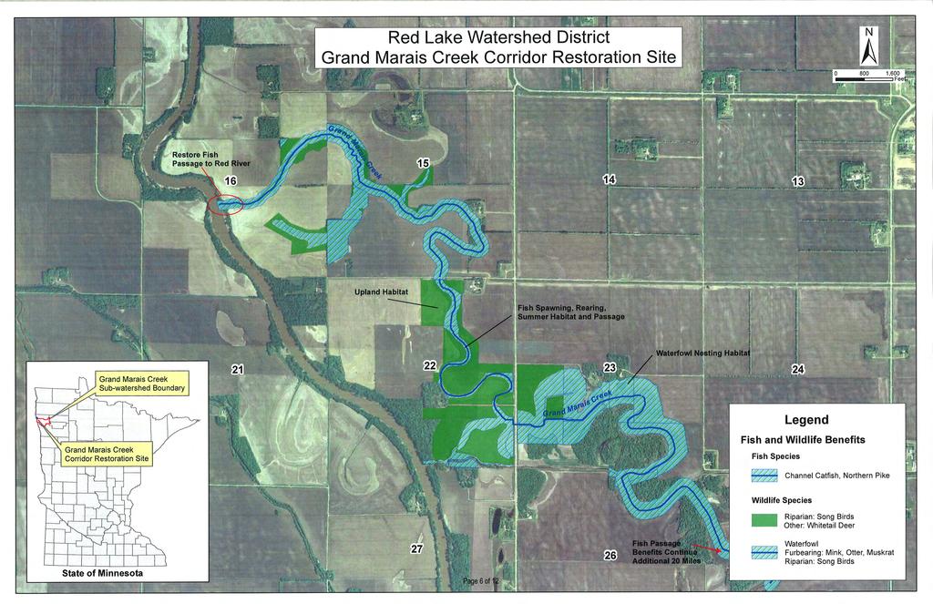
68 APPENDIX F Fish and Wildlife Benefits Map
69
70 APPENDIX G EAW and Findings of Fact
71

72
73
74
75
76
77
78
79
80
81
82
83
84
85
86
87

88
89
90
91
92 APPENDIX H Project Schedule

93
WHETSTONE RIVER RESTORATION PROJECT - ADDENDUM
 DRAFT WHETSTONE RIVER RESTORATION PROJECT - ADDENDUM Upper Minnesota Watershed District February 2, 2015 I hereby certify that this plan, specification, or report was prepared by me or under my direct
4. Present Activities and Roles
 4. Present Activities and Roles The present missions, authorities, activities and roles of the various agencies involved with flood protection, floodplain management and flood-damage reduction are identified
awetlands aprairie aforests ahabitat for Fish, Game & Wildlife
 Rec. H1 priority land habitats pp. 63-67 Priority areas identified in integrated mapping assessing critical land habitat and threats to habitat pp.33-63 o Mapping is scalable for use in localized areas
Phase II: Proposed (regulated) Impervious in disturbed area (ac) Long Lake Existing Impervious in disturbed area (ac)
 Impervious in disturbed area (ac) Long Lake Existing Impervious in disturbed area (ac)") Permit Application No.: 17-181 Rules: Erosion Control, Wetland Protection, and Waterbody Crossings & Structures Applicant: Hennepin County Received: 4/27/17 Project: CSAH 112 Phase II Complete: 9/5/17
Permit Application No.: 17-181 Rules: Erosion Control, Wetland Protection, and Waterbody Crossings & Structures Applicant: Hennepin County Received: 4/27/17 Project: CSAH 112 Phase II Complete: 9/5/17
BWSR PROGRAMS THAT ADDRESS NUTRIENT LOSS
 BWSR PROGRAMS THAT ADDRESS NUTRIENT LOSS DRAINAGE LAW BUFFER PROGRAM CREP - GRANT PROGRAMS - PROJECTS 2017 MVTL Agronomy Update Meeting New Ulm, MN February 28, 2017 Jill Sackett Eberhart ~ BWSR Board
Section 6: Stormwater Improvements
 Section 6: Stormwater Improvements A major objective of this study was to identify opportunities for improvements to address the widespread water quality impairments caused by stormwater runoff in the
Appendix D - Evaluation of Interim Solutions
 Appendix D - Evaluation of Interim Solutions D.1 Introduction The implementation of long-term improvements is projected to take 5 to 8 years. To reduce the number of years of flooding impacts, the partner
SECTION 10: WETLANDS PROTECTION
 SECTION 10: WETLANDS PROTECTION 10-1 INTENT AND PURPOSE A. Intent 1. The City finds that wetlands serve a variety of beneficial functions. Wetlands maintain water quality, reduce flooding and erosion,
Appendix E : Guidelines for Riparian Buffer Areas
 Appendix E : Guidelines for Riparian Buffer Areas This document should be read in conjunction with the CRCA Planning Policy. 1.0 PURPOSE The purpose of this document is to summarize the recommendations
Appendix K Civil Engineering
 Appendix K Civil Engineering Fargo-Moorhead Metropolitan Area Flood Risk Management Final Feasibility Report and Environmental Impact Statement Prepared by: U.S. Army Corps of Engineers St. Paul District
APPENDIX G DIVERSION AND PELICAN LAKE CUTOFF CHANNELS HYRAULICS AND BRIDGE TECHNICAL MEMORANDUM
 APPENDIX G DIVERSION AND PELICAN LAKE CUTOFF CHANNELS HYRAULICS AND BRIDGE TECHNICAL MEMORANDUM To: File Memo From: Matt Redington, P.E. Project: Watertown South Connector CC: Date: March 6, 2007; revised
SECTION 7.0 PROJECT FEASIBILITY, ENGINEER S RECOMMENDATION AND DESIGN ISSUES NEEDING RESOLUTION
 SECTION 7.0 PROJECT FEASIBILITY, ENGINEER S RECOMMENDATION AND DESIGN ISSUES NEEDING RESOLUTION 7.1 PROJECT FEASIBILITY The determination of project feasibility is based upon several criteria established
Agricultural/Rural Riparian Buffer Analysis
 Agricultural/Rural Riparian Buffer Analysis December 2014 Executive Summary The Agricultural/Rural Riparian Buffer Analysis was developed from a 2014 analysis of current requirements for the riparian areas
Environmental Information Worksheet
 Environmental Information Worksheet Water System Owner (Attach additional sheets if necessary) Needs and Alternatives Provide a brief narrative that describes: Current drinking water system needs. Project
Chapter 6 Erosion & Stormwater Study Team
 Chapter 6 Erosion & Stormwater Study Team Objective How do we stabilize the Las Vegas Wash environment to most effectively reduce erosion and enhance wetlands? Introduction The Las Vegas Wash (Wash) has
BRANDT IMPOUNDMENT OUTLET DITCH ESTABLISHEMENT PRELIMINARY SURVEY REPORT
 BRANDT IMPOUNDMENT OUTLET DITCH ESTABLISHEMENT PRELIMINARY SURVEY REPORT PROPOSED AS: RED LAKE WATERSHED DISTRICT DITCH #15 RLWD Project No. 175 HDR Project No. 186028 Engineering Inc. 324 2nd Street East
Appendix Q Draft Location Hydraulic Study Report For the State Route 32 Widening Between Fir Street and Yosemite Drive at Dead Horse Slough and South
 Appendix Q Draft Location Hydraulic Study Report For the State Route 32 Widening Between Fir Street and Yosemite Drive at Dead Horse Slough and South Fork Dead Horse Slough in the, California Draft Location
Will be modified map from GIS 6/16 EOD
 Middle-Snake-Tamarac Rivers Watershed District Judicial Ditch #19 Watershed Regional Conservation Partnership Program (RCPP) Public Scoping Meeting September 26, 2016 Will be modified map from GIS 6/16
Bluff Creek One Water
 Bluff Creek One Water The Bluff Creek Watershed has no lakes within its boundaries. As the westernmost watershed within the District, land use changes from agricultural to residential have occurred relatively
CHAPTER 3 Environmental Guidelines for WATERCOURSE CROSSINGS GOVERNMENT OF NEWFOUNDLAND AND LABRADOR DEPARTMENT OF ENVIRONMENT AND LABOUR
 GOVERNMENT OF NEWFOUNDLAND AND LABRADOR DEPARTMENT OF ENVIRONMENT AND LABOUR CHAPTER 3 Environmental Guidelines for WATERCOURSE CROSSINGS WATER RESOURCES MANAGEMENT DIVISION Water Investigations Section
Upper Lightning Lake Water Level Management Environmental Assessment Worksheet. Attachment D Design Report for Upper Lightning Lake
 Upper Lightning Lake Water Level Management Environmental Assessment Worksheet Attachment D Design Report for Upper Lightning Lake DESIGN REPORT for Upper Lightning Lake Wetland Enhancement MN-332-2 I
Understanding and Restoring Natural Floodplain Function. Gary James CTUIR Fisheries Program Manager
 Understanding and Restoring Natural Floodplain Function Gary James Fisheries Program Manager Future of Our Salmon Technical Workshop on Healthy Floodplains Spokane, WA - August 16-18, 2016 Presentation
Hydrology and Flooding
 Hydrology and Flooding Background The 1996 flood Between February 4, 1996 and February 9, 1996 the Nehalem reporting station received 28.9 inches of rain. Approximately 14 inches fell in one 48 hour period.
U.S. Army Corps of Engineers (USACE) Galveston District
 Galveston District") Appendix II U.S. Army Corps of Engineers (USACE) Galveston District SWG MITIGATION BANK PROSPECTUS TEMPLATE This Template includes the information required for a mitigation bank prospectus as outlined
Appendix II U.S. Army Corps of Engineers (USACE) Galveston District SWG MITIGATION BANK PROSPECTUS TEMPLATE This Template includes the information required for a mitigation bank prospectus as outlined
Appendix B Stormwater Site Plan Submittal Requirements Checklist
 Stormwater Site Plan Submittal Requirements Checklist The Submittal Requirements Checklist is intended to aid the design engineer in preparing a Stormwater Site Plan. All items included in the following
City of Mississauga Environmental Impact Studies Terms of Reference 2002
 City of Mississauga Environmental Impact Studies Terms of Reference 2002 1.0 INTRODUCTION To ensure in so far as possible, both private and public developments are consistent with Natural Heritage and
Oshawa Creek Watershed Management Plan EXECUTIVE SUMMARY
 Oshawa Creek Watershed Management Plan EXECUTIVE SUMMARY The Central Lake Ontario Conservation Authority (CLOCA) has recognized the need to prepare comprehensive management strategies for all of its watersheds.
DAKOTA COUNTY SOIL AND WATER CONSERVATION DISTRICT COMPREHENSIVE PLAN
 DAKOTA COUNTY SOIL AND WATER CONSERVATION DISTRICT COMPREHENSIVE PLAN 2011-2015 4100 220 th Street West, Suite 102 Farmington, MN 55024 651-480-7777 www.dakotacountyswcd.org I. INTRODUCTION A. Purpose
APPENDIX A HYDROLOGIC AND HYDRAULIC ANALYSIS
 APPENDIX A HYDROLOGIC AND HYDRAULIC ANALYSIS GENERAL The Hydrologic and Hydraulic information presented in this appendix is provided as a supplement to the Dallas Floodway Extension General Re-evaluation
3D WETLAND MANAGEMENT
 3D WETLAND MANAGEMENT 1. ISSUE Wetlands are one of the most productive ecosystems. They provide biological and chemical functions to the landscape that serve the watershed including the moderation of nutrient
Project Goals and Scoping
 Prepared for: Boulder County, Colorado Flood Planning & Preliminary Design Services for South St. Vrain Creek Restoration at Hall Ranch and Scoping May 24, 2016 Meeting with General Public In association
Model Riparian Buffer Ordinance.
 Model Riparian Buffer Ordinance. This is a sample riparian buffer ordinance written as an amendment to an existing zoning ordinance. This ordinance complies with the state minimum standards for river corridor
The Nature Conservancy Cosumnes River Preserve Franklin Boulevard Galt CA 95632
 Study Partners The Nature Conservancy Cosumnes River Preserve 13501 Franklin Boulevard Galt CA 95632 East Bay Municipal Utility District 1 Winemaker Way, Unit K Lodi CA 95240 Sacramento County Water Agency
Old Mill School Stream Restoration
 Project Overview This conceptual plan restores and stabilizes two consecutive reaches of a highly incised and unstable stream and reconnects them with the floodplain. The restoration reaches are part of
Distributed Storage Alternative Screening Analysis February 17, 2015
 Distributed Storage Alternative Screening Analysis February 17, 2015 Executive Summary The Distributed Storage Alternative (DSA) was conceptualized during the public comment and alternative screening process
Minnesota EAW Supplement
 Appendix I: Minnesota EAW Supplement Lower Pool 2 Channel Management Study: Boulanger Bend to Lock and Dam No. 2 Minnesota EAW Item Identification A supplement prepared for the Minnesota DNR to identify
BMP 5.4.2: Protect /Conserve/Enhance Riparian Areas
 BMP 5.4.2: Protect /Conserve/Enhance Riparian Areas The Executive Council of the Chesapeake Bay Program defines a Riparian Forest Buffer as "an area of trees, usually accompanied by shrubs and other vegetation,
Cokato Lake (86-263) Wright County. Hydrologic Investigation
 Wright County. Hydrologic Investigation") Cokato Lake (86-263) Wright County Hydrologic Investigation April 14, 2005 Cokato Lake (86-263) Wright County Hydrologic Investigation April 14, 2005 Problem Statement In recent years, heavy rainfall has
Cokato Lake (86-263) Wright County Hydrologic Investigation April 14, 2005 Cokato Lake (86-263) Wright County Hydrologic Investigation April 14, 2005 Problem Statement In recent years, heavy rainfall has
Chehalis Basin Strategy Programmatic SEPA Draft EIS
 Chehalis Basin Strategy Programmatic SEPA Draft EIS History of Flooding I-5 closed in 1990, 1996, 2007, 2009 Five largest flood events occurred since 1986 2 History of Habitat Degradation Harvest has been
CLEARWATER TOWNSHIP WATER QUALITY ACTION PLAN
 CLEARWATER TOWNSHIP WATER QUALITY ACTION PLAN Elk-River-Chain-of-Lakes Gaps Analysis Project The Watershed Center Grand Traverse Bay Michigan Department of Environmental Quality July 2011 Purpose The Grand
CITY OF NEW WESTMINSTER. Bylaw No. 7033, 2005 RIPARIAN AREAS PROTECTION BYLAW
 CITY OF NEW WESTMINSTER Bylaw No. 7033, 2005 RIPARIAN AREAS PROTECTION BYLAW WHEREAS the City may preserve, protect, restore and enhance the natural environment near streams that support fish habitat from
STAFF REPORT FOR POLICY PLAN AMENDMENT S10-CW-1CP
 STAFF REPORT FOR POLICY PLAN AMENDMENT S10-CW-1CP EXECUTIVE SUMMARY This Plan Amendment would serve to clarify policy guidance regarding circumstances under which proposals for disturbances to Environmental
OFFICE OF STRUCTURES MANUAL ON HYDROLOGIC AND HYDRAULIC DESIGN CHAPTER 3 POLICY AND PROCEDURES
 OFFICE OF STRUCTURES MANUAL ON HYDROLOGIC AND HYDRAULIC DESIGN CHAPTER 3 POLICY AND PROCEDURES April 28, 2016 Table of Contents 3.1 Introduction... 2 3.1.1 Purpose of Chapter 3... 2 3.1.2 Policy vs. Design
TABLE OF CONTENTS. 1.0 Background Watershed Description Hydrology - HEC-HMS Models Hydraulics - HEC-RAS Models...
 TABLE OF CONTENTS 1.0 Background... 1 2.0 Watershed Description... 1 3.0 Hydrology - HEC-HMS Models... 2 3.1 Hydrologic Approach... 2 3.2 Drainage Areas... 2 3.3 Curve Numbers... 2 3.4 Lag Times... 3 3.5
The Beckett s Run Experience. Fort Wayne, Indiana
 The Beckett s Run Experience Fort Wayne, Indiana Introductions Charlie Cochran City of Fort Wayne, Wet Weather Storm & Sewer Engineering Jason Durr, PE Christopher B. Burke Engineering, LLC 2 A Little
PRESENTERS. Contact Information: RW Armstrong Union Station, 300 S. Meridian St. Indianapolis, IN
 1 PRESENTERS David Bourff, Director of Environmental Planning Simon Davies, LEED AP, Environmental Scientist Summer O Brien, PWS, Senior Environmental Scientist Contact Information: RW Armstrong Union
INDIAN CREEK WATERSHED PLAN EXECUTIVE SUMMARY
 INDIAN CREEK WATERSHED PLAN EXECUTIVE SUMMARY The Indian Creek Watershed covers a 38 square mile area in southern Lake County, Illinois that drains 24,116 acres before discharging into the Des Plaines
FINDINGS OF FACT And CONCLUSIONS
 FINDINGS OF FACT And CONCLUSIONS SOUTHWEST RECONNECTION PROJECT Highway 61/101 Flood Mitigation State Project No. 1009-24 and State Aid Project No. 010-661-002 Prepared for: Carver County September 2013
Ceresco Dam Removal Project. Michigan Watershed Summit March 25, 2015 Luke Trumble, P.E., MDEQ-WRD Jay Wesley, MDNR-Fisheries
 Ceresco Dam Removal Project Michigan Watershed Summit March 25, 2015 Luke Trumble, P.E., MDEQ-WRD Jay Wesley, MDNR-Fisheries Outline Overview of Ceresco Dam History Public Process Funding Dam Removal Ecosystem
AGRICULTURAL DRAINAGE
 AGRICULTURAL DRAINAGE ARCHITECTURE + ENGINEERING + True Expertise + Sustainable Solutions ENVIRONMENTAL + PLANNING Facing the Challenges Together With over 40 years of experience, ISG is focused on improving
Wetland Impact Assessment & Two Part Finding Form
 Office of Environmental Stewardship 395 John Ireland Blvd. St. Paul, MN 5555 February 208 Wetland Impact Assessment & Two Part Finding Form ** Red text provides descriptive guidance and should be replaced/removed
Drainage Criteria Manual Review
 City of Colorado Springs Stormwater Management Assessment and Standards Development Drainage Criteria Manual Review March 8, 2013 Springsgov.com/City Agencies/Stormwater/Stormwater Engineering/ Stormwater
COMMONWEALTH OF PENNSYLVANIA DEPARTMENT OF ENVIRONMENTAL PROTECTION
 COMMONWEALTH OF PENNSYLVANIA DEPARTMENT OF ENVIRONMENTAL PROTECTION PERMIT GUIDELINES FOR PHASED NPDES STORMWATER DISCHARGES ASSOCIATED WITH CONSTRUCTION ACTIVITY PERMITS, CHAPTER 102 EROSION AND SEDIMENT
Burke Creek Highway 50 Crossing and Realignment Project Monitoring Plan
 Burke Creek Highway 50 Crossing and Realignment Project Monitoring Plan Table of Contents Table of Figures... i Introduction... 1 Background... 1 Burke Creek Issues... 2 Monitoring Objectives and Goals...
Plan Rollout Presentation July 31, Michael G. Hahn, P.E., P.H. Chief Environmental Engineer. Southeastern Wisconsin Regional Planning Commission
 Plan Rollout Presentation July 31, 2014 Michael G. Hahn, P.E., P.H. Chief Environmental Engineer Southeastern Wisconsin Regional Planning Commission # 219703 Racine County Flooding Recommendations and
Preliminary Feasibility Study for South San Francisco Bay Shoreline Economic Impact Areas 1-10 Executive Summary
 Economic Impact Areas 1-10 Executive Summary Prepared For: Department of Water Resource Division of Flood Management State Of California Prepared By: Santa Clara Valley Water District February 2017 A preliminary
Fargo-Moorhead Flood Risk Management Project Supplement to Environmental Impact Statement (SEIS) Final Preparation Notice May 21, 2018
 Final Preparation Notice May 21, 2018") Fargo-Moorhead Flood Risk Management Project Supplement to Environmental Impact Statement (SEIS) Final Preparation Notice May 21, 2018 1. Title of EIS being supplemented and date of completion: Final Environmental
Fargo-Moorhead Flood Risk Management Project Supplement to Environmental Impact Statement (SEIS) Final Preparation Notice May 21, 2018 1. Title of EIS being supplemented and date of completion: Final Environmental
Lake Samish Comprehensive Stormwater Plan Capital Improvement Recommendations
 Lake Samish Comprehensive Stormwater Plan Capital Improvement Recommendations drainage. The easement could potentially be used to site a surface water quality treatment facility for the flow. The design
Conceptual Design and Feasibility of a Natural Fishway at the Fremont BART Weir, Alameda Creek, California
 Conceptual Design and Feasibility of a Natural Fishway at the Fremont BART Weir, Alameda Creek, California Final Report September 2005 Prepared by Center for Ecosystem Management and Restoration, Oakland,
ANCR INDIVIDUAL RESPONSES SUMMARY: 2/11/04 WATER RESOURCES GOALS AND OBJECTIVES
 ANCR INDIVIDUAL RESPONSES SUMMARY: 2/11/04 WATER RESOURCES GOALS AND OBJECTIVES Goal 1: Protect the health and safety of the Dane County population. a. Prevent development that may have an adverse effect
CLAY STREET BRIDGE REPLACEMENT
 HYDROLOGY /HYDRAULICS REPORT. EL DORADO COUNTY CLAY STREET BRIDGE REPLACEMENT Prepared by: Joseph Domenichelli Domenichelli & Associates 1107 Investment Blvd., Suite 145 El Dorado Hills, California 95762
Stormwater Erosion Control & Post-Construction Plans (Stormwater Quality Plans)
") Stormwater Erosion Control & Post-Construction Plans (Stormwater Quality Plans) Allen County Stormwater Plan Submittal Checklist The following items must be provided when applying for an Allen County Stormwater
Stormwater Erosion Control & Post-Construction Plans (Stormwater Quality Plans) Allen County Stormwater Plan Submittal Checklist The following items must be provided when applying for an Allen County Stormwater
Public Information Centre September 19 th, 2017
 Public Information Centre September 19 th, 2017 WELCOME! Public Information Centre for the Maple Hill Creek Rehabilitation Class Environmental Assessment Please take the time to sign our sign in sheet
Warren Wagon Road Improvement Project McCall Ranger District, Payette National Forest Project Description
 Warren Wagon Road Improvement Project McCall Ranger District, Payette National Forest Project Description Introduction The analysis of the Warren Wagon Road Improvement Project is tiered to the 2003 Environmental
COON CREEK WATERSHED DISTRICT PERMIT REVIEW
 16-054 Woodland Creek Wetland Banking Restoration Project, Page 1 of 6 COON CREEK WATERSHED DISTRICT PERMIT REVIEW MEETING DATE: August 22, 2016 AGENDA NUMBER: 11 FILE NUMBER: 16-054 ITEM: Woodland Creek
Southeast Policy Area Drainage Study
 Southeast Policy Area Drainage Study Prepared for City of Elk Grove January 2014 448-00-12-03 Table of Contents 1.0 Introduction... 1 2.0 Watershed Description... 1 3.0 Drainage Plan Concept... 1 4.0
Public Notice ISSUED: 20-JAN-2016 EXPIRES: 19-FEB-2016
 APPLICANT: Shakopee Mdewakanton Sioux Community Public Notice ISSUED: 20-JAN-2016 EXPIRES: 19-FEB-2016 REFER TO: MVP-2015-04726-RMM SECTION: 404 - Clean Water Act 1. APPLICATION FOR PERMIT TO discharge
Compensatory Mitigation Plan Requirements For Permittee Responsible Mitigation Projects St. Louis District, Corps of Engineers May 2010
 Compensatory Mitigation Plan Requirements For Permittee Responsible Mitigation Projects St. Louis District, Corps of Engineers May 2010 The U.S. Army Corps of Engineers (Corps) and U.S. Environmental Protection
Hydrologic Regime; Past and Present and Water Quality Implications
 Hydrologic Regime; Past and Present and Water Quality Implications Waseca County Water Plan Meeting Waseca County Courthouse Annex November 16, 2016 Dan Girolamo, Area Hydrologist, Waterville, MN Topics
REROUTING DRAINAGE SYSTEMS
 MINNESOTA WETLAND RESTORATION GUIDE REROUTING DRAINAGE SYSTEMS TECHNICAL GUIDANCE DOCUMENT Document No.: WRG 4A-4 Publication Date: 10/14/2015 Table of Contents Introduction Application Design Considerations
Responses to Comments from State Agencies
 Summary of Comment Letters Received from State Agencies This section provides responses to comments received on the draft environmental document from state agencies. Comment Code Agency S-1 California
RIPARIAN AREAS REGULATION
 Definitions and interpretation RIPARIAN AREAS REGULATION 1 (1) In this regulation: Act means the Fish Protection Act; active floodplain means an area of land that supports floodplain plant species and
APPENDIX H JOINT PUBLIC NOTICE
 APPENDIX H JOINT PUBLIC NOTICE DEPARTMENT OF THE ARMY SAVANNAH DISTRICT, CORPS OF ENGINEERS 100 W. OGLETHORPE AVENUE SAVANNAH, GEORGIA 31401-3604 August 17, 2016 JOINT PUBLIC NOTICE U.S. Army Corps of
Watershed Hydrology: Go with the flow. Greg Jennings, PhD, PE
 Watershed Hydrology: Go with the flow Greg Jennings, PhD, PE jenningsenv@gmail.com Streams What are your CHALLENGES? Hydrology too much water Pollutants upstream and on-site Vegetation wrong plants, wrong
ELK RAPIDS TOWNSHIP WATER QUALITY ACTION PLAN
 ELK RAPIDS TOWNSHIP WATER QUALITY ACTION PLAN Elk-River-Chain-of-Lakes Gaps Analysis Project The Watershed Center Grand Traverse Bay Tip of the Mitt Watershed Council Michigan Department of Natural Resources
SW-74 SERENOVA PRESERVE SITES 2, 3, 4, 8 MITIGATION PLAN
 SW-74 SERENOVA PRESERVE SITES 2, 3, 4, 8 MITIGATION PLAN BACKGROUND INFORMATION Project SWIM? Aquatic Control? Exotic Control? Mitigation Bank? Type No No No No Mitigation Restoration and enhancement Type
PROSPECTUS. Proposed Beech River Canal Wetland and Stream Mitigation Bank
 PROSPECTUS Proposed Beech River Canal Wetland and Stream Mitigation Bank INTRODUCTION This prospectus provides an overview of Beech River Farms, LLC s (BRF) proposed Beech River Canal Wetland and Stream
AGRICULTURAL DRAINAGE
 AGRICULTURAL DRAINAGE ARCHITECTURE + ENGINEERING + ENVIRONMENTAL + PLANNING True Expertise + Sustainable Solutions Facing the Challenges Together With over 40 years of experience, ISG is focused on improving
Hydraulic Report. County Road 595 Bridge over Mulligan Creek. Prepared By AECOM Brian A. Hintsala, P.E
 Prepared for: Prepared by: Marquette County Road Commission AECOM Ishpeming, MI Marquette, MI 60240279 December 9. 2011 Hydraulic Report County Road 595 Bridge over Mulligan Creek Prepared By AECOM Brian
Final Report of the Riparian Forest Buffer Panel
 Chesapeake Bay Program Final Report of the Riparian Forest Buffer Panel Introduction Findings Land Use-Specific Findings On Agricultural Land On Forested Land On Developed and Developing Lands Recommendations
EXECUTIVE SUMMARY DES PLAINES RIVER WATERSHED-BASED PLAN WHY A WATERSHED-BASED PLAN? WHAT IS A WATERSHED?
 Des Plaines River Watershed-Based Plan EXECUTIVE SUMMARY June 2018 EXECUTIVE SUMMARY DES PLAINES RIVER WATERSHED-BASED PLAN WHY A WATERSHED-BASED PLAN? Water is elemental to our lives. Plants and animals,
Clearwater River Stream Bank Stabilization and Revitalization Project
 Clearwater River Stream Bank Stabilization and Revitalization Project In 2001 the RLWD continued work on the Clearwater River Stream Bank Stabilization and Revitalization Project. The work performed during
TABLE OF CONTENTS. Introduction. Lower Platte South NRD Past and Present 1. Map of Lower Platte South NRD 2. Vision for the Future 3.
 TABLE OF CONTENTS Introduction ii Lower Platte South NRD Past and Present 1 Map of Lower Platte South NRD 2 Vision for the Future 3 Vision Table 5 i INTRODUCTION The Master Plan is the document that expresses
Supplemental Watershed Plan Agreement No. 10 for Neshaminy Creek Watershed Core Creek Dam (PA-620) Bucks County, Pennsylvania
 Bucks County, Pennsylvania") Supplemental Watershed Plan Agreement No. 10 for Neshaminy Creek Watershed Core Creek Dam (PA-620) Bucks County, Pennsylvania Project Authorization USDA's Small Watershed Program is carried out under the
Supplemental Watershed Plan Agreement No. 10 for Neshaminy Creek Watershed Core Creek Dam (PA-620) Bucks County, Pennsylvania Project Authorization USDA's Small Watershed Program is carried out under the
ENGINEER S FEASIBILITY REPORT Shamineau Lake Outlet Investigation Morrison County Motley, Minnesota January 23, 2018
 ENGINEER S FEASIBILITY REPORT Shamineau Lake Outlet Investigation Morrison County Motley, Minnesota January 23, 2018 I hereby certify that this plan, specification, or report was prepared by me or under
APPENDIX A. Project Scoping
 APPENDIX A Project Scoping Notice of Preparation To: From: Agencies and Interested Parties Paul Brunner, Executive Director, Three Rivers Levee Improvement Authority Date: June 13, 2006 Subject: Notice
ILLINOIS URBAN MANUAL PRACTICE STANDARD TEMPORARY STREAM CROSSING (no.) CODE 975. Source: Hey and Associates, Inc.
 CODE 975. Source: Hey and Associates, Inc.") ILLINOIS URBAN MANUAL PRACTICE STANDARD TEMPORARY STREAM CROSSING (no.) CODE 975 Source: Hey and Associates, Inc. DEFINITION A bridge or culvert crossing installed across a stream or watercourse for short-term
ILLINOIS URBAN MANUAL PRACTICE STANDARD TEMPORARY STREAM CROSSING (no.) CODE 975 Source: Hey and Associates, Inc. DEFINITION A bridge or culvert crossing installed across a stream or watercourse for short-term
Projects and Practices Application
 Projects and Practices Application Grant Name - Water Harvest and Reuse at Oak Glen Golf Course Grant ID - C19-2907 Organization - Browns Creek WD Allocation Projects and Practices 2019 Grant Contact Karen
Wood-Pawcatuck Watershed Flood Resiliency Management Plan
 Wood-Pawcatuck Watershed Flood Resiliency Management Plan Project Steering Committee Meeting May 21, 2015 Wood-Pawcatuck Watershed Association Meeting Agenda 10:00 10:05 Welcome and Opening Remarks 10:05
Cannon River One Watershed, One Plan. POLICY COMMITTEE MEETING January 10, 2018 Rice County Government Center Faribault, MN
 Cannon River One, One Plan POLICY COMMITTEE MEETING January 10, 2018 Rice County Government Center Faribault, MN TASK Task 1. Aggregate Existing Physical & Spatial Data 1A. Create project maps 1B. Meeting
CHAPTER 7. San Dieguito River Flooding Adaptation
 CHAPTER 7 San Dieguito River Flooding Adaptation This chapter includes a range of adaptation measures to address vulnerabilities from flooding along the San Dieguito River, including the river valley,
12 DRAINAGE General Administrative Requirements Standards
 12 DRAINAGE 12.1 General The Design-Builder shall conduct all Work necessary to meet the requirements associated with drainage, including culverts, bridge hydraulics, roadway ditches, and closed storm
Public Notice ISSUED: 11 February 2019 EXPIRES: 13 March 2019
 SPONSOR: Minnesota Board of Water and Soil Resources Public Notice ISSUED: 11 February 2019 EXPIRES: 13 March 2019 REFER TO: MVP-2019-0122-JTB SECTION: 404 - Clean Water Act 1. WETLAND COMPENSATORY MITIGATION
Primer introduction to watershed management Plan Process highlight the major steps of plan development Project types look at some examples of common
 1 Primer introduction to watershed management Plan Process highlight the major steps of plan development Project types look at some examples of common projects Plan Organization how to read the plan Next
Appendix P. U.S. Fish and Wildlife Service Planning Aid Letter
 Appendix P U.S. Fish and Wildlife Service Planning Aid Letter This page is intentionally left blank. United States Department of the Interior FISH AND WILDLIFE SERVICE Missouri Ecological Services Field
DRAINAGE STUDY PHASE 2 REPORT HORRY COUNTY STORMWATER DEPARTMENT HIGHWAY 9 & 57 HORRY COUNTY, SC PREPARED FOR: APRIL 07, 2016 J
 DRAINAGE STUDY PHASE 2 REPORT FOR: HIGHWAY 9 & 57 HORRY COUNTY, SC PREPARED FOR: HORRY COUNTY STORMWATER DEPARTMENT APRIL 07, 2016 Prepared by: Savannah, GA Charleston, SC Myrtle Beach, SC Brunswick, GA
Upper Mississippi River Floodplain Island Restoration Details
 Upper Mississippi River Floodplain Island Restoration Details Mississippi Makeover Meeting Citizens Advisory Group December 1, 2009 Hastings City Hall Community Room Scot Johnson Minnesota Department of
S.R. 4007, Section 14B PADEP Environmental Assessment Form. Enclosure C Description of Aquatic Habitat
 S.R. 4007, Section 14B PADEP Environmental Assessment Form Description of Aquatic Habitat Cresheim Creek is the only water resource that exists within the project area. No jurisdictional wetlands were
CHAPTER 10 CRITICAL DRAINAGE AREAS
 CHAPTER 10 CRITICAL DRAINAGE AREAS Contents 10.0 INTRODUCTION 10-1 10.1 IDENTIFICATION OF CRITICAL DRAINAGE AREAS 10-1 10.1.1 Site Physical Attributes 10-2 10.1.2 Protection of Fish & Wildlife Habitat
Preface. MNR # Queen s Printer for Ontario, 2012 ISBN (PRINT) ISBN (PDF)
 ISBN (PDF)") Preface In 2008, the inter-agency Drainage Act & Section 28 Regulations Team (DART) was established by the Ministry of Natural Resources (MNR) and the Ministry of Agriculture, Food and Rural Affairs (OMAFRA)
Preface In 2008, the inter-agency Drainage Act & Section 28 Regulations Team (DART) was established by the Ministry of Natural Resources (MNR) and the Ministry of Agriculture, Food and Rural Affairs (OMAFRA)