Using Google s Aggregated and Anonymized Trip Data to Support Freeway Corridor Management Planning in San Francisco
|
|
|
- Marion Chandler
- 5 years ago
- Views:
Transcription
1 Using Google s Aggregated and Anonymized Trip Data to Support Freeway Corridor Management Planning in San Francisco Bhargava Sana, Joe Castiglione, Dan Tischler, Drew Cooper SAN FRANCISCO COUNTY TRANSPORTATION AUTHORITY January 11, 2017
2 Outline Background on Freeway Corridor Management Study (FCMS) and OD data sources Google s Aggregated and Anonymized Trip (AAT) data AAT application and validation Estimate roadway facility-specific OD matrices Conclusions Limitations and next steps
 US-101 I-280 Corridor Potential strategies TDM,")

3 Background: San Francisco Freeway Corridor Management Study (FCMS) US-101 I-280 Corridor Potential strategies TDM, managed lanes Ramp metering OD data could help impute Socio-demographics (age, income, auto ownership etc.) Willingness To Pay (WTP)


4 Background: OD Data Collection Conventional methods License plate surveys Roadside interviews/questionnaires Emerging passive data collection methods Bluetooth detectors Cell phone Call Detail Records (CDR) data
 information from location reports Extract data from moving users Clean data and snap to road network Aggregate OD trip counts Apply differential")
5 Aggregated and Anonymized Trip (AAT) Data Google s Better Cities Program Minimize congestion, improve safety and reduce infrastructure spending Users opt-in to share location GPS, cell-phone towers, Wi-Fi detectors Aggregated and Anonymized Trip (AAT) information from location reports Extract data from moving users Clean data and snap to road network Aggregate OD trip counts Apply differential privacy filters and minimum trips threshold 5


6 AAT Dataset for FCMS 85-district system: combination of Tract and County boundaries via polygons for 4 segments around US-101 and I-280 interchange in San Francisco Hourly AAT data for six months (Apr-Jun and Sep-Nov 2015) 6

7 AAT Application Considerations Flow data provided as relative trips as opposed to absolute counts Trips needed for planning purposes Convert relative flows to trips? 7

8 Caltrans Performance Measurement System (PeMS) Continuously monitors speeds and volumes using detectors Over 39,000 detectors on freeways all across California PeMS counts available for same time and location as AAT Why not compare to Google AAT flows? PeMS vehicle counts -> person trips Observed auto occupancy applied by location and time of day 8

9 Comparison to PeMS Corridor Flows Weekday Hourly Bi-Directional Flows Summary Freeway Google AAT Relative Flows PeMS (Vehs/Hr) Segment Count Mean Min Max Count Mean Min Max North on US-101 2, E E E-02 1,845 9, ,885 South on US-101 2, E E E-02 1,863 9, ,310 North on I-280 2, E E E-03 1,872 3, ,216 South on I-280 2, E E E-03 1,872 6, ,019 9
 OD Flows Pearson s")

10 Comparison to SF-CHAMP (ABM) OD Flows Pearson s correlation = Pearson s correlation =
11 Relative Flow Conversion Models AAT relative flows vary by Hour of day: added indicator variables Roadway segment location: separate models estimated Several model forms and transformations explored PT t = K + β f log RF t + β t + ϵ ; 0 t 23 PT t K β f RF t β t ϵ : Person trips on roadway facility for hour-of-day t : Regression constant/intercept : Coefficient of AAT relative flow : AAT relative flow for hour-of-day t : Constant for hour-of-day t : Error term 11

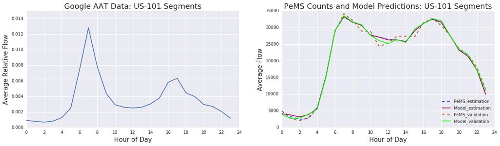
12 Model Validation 12

13 Comparison of Facility-Specific OD Matrices with SF-CHAMP Select Link Correlation Coefficient Time Period Segment County level District level US-101 north of interchange AM Peak US-101 south of interchange I-280 north of interchange I-280 south of interchange US-101 north of interchange PM Peak US-101 south of interchange I-280 north of interchange I-280 south of interchange
14 Summary and Conclusions New passive dataset (AAT) obtained from Google Processed mobile users location reports Reasonable regional flow patterns High correlation with calibrated TDM flows Statistical relationship: AAT & observed counts (PeMS) Appears to vary by hour-of-day and facility Hourly facility-specific OD matrices O & D trips ends better correlated with model select link 14
15 Limitations and Next Steps Limitations Google s AAT data significantly processed to protect privacy Minimum trips threshold for reporting At the time of analysis AAT only available for vehicular traffic Analysis limited to freeway corridors AAT most likely represent person trips and not vehicle trips Auto occupancy assumptions may be needed Next Steps Compare AAT and cellphone CDR OD flows Leverage the longitudinal aspect to perform before-after studies 15
16 Thank You SAN FRANCISCO COUNTY TRANSPORTATION AUTHORITY
17 Estimation Results US-101 I-280 Coefficient Std. Err. t-stat Coefficient Std. Err. t-stat Intercept log(weight) Hour Hour Hour Hour Hour Hour Hour Hour Hour Hour Hour Hour Hour Hour Hour Hour Hour Hour Hour No. of observations Log-Likelihood R-squared Adj. R-squared
Exploring Google s Passive Data for Origin-Destination Demand Estimation
 Exploring Google s Passive Data for Origin-Destination Demand Estimation 2018 SF Bay Area ITE/ITS CA Joint Transportation Workshop Bhargava Sana SAN FRANCISCO COUNTY TRANSPORTATION AUTHORITY May 2, 2018
Database and Travel Demand Model
 Database and Travel Demand Model 7 The CMP legislation requires every CMA, in consultation with the regional transportation planning agency (the Metropolitan Transportation Commission (MTC) in the Bay
idaxdata.com GPS Probe Data Collection and Applications
 GPS Probe Data Collection and Applications Scott Lee, PE scott.lee@ 425-614-6231 Presentation Overview Introduction to GPS Probe Data Collection Available Applications Through Dataset Providers Application
Planning Commission Study Session. Presentation
 Planning Commission Study Session Presentation Traffic Model Operation and Summary of the Rail Corridor Plan Traffic Study Results Traffic Model Background Examples of Analysis Techniques Traffic Study
Presented by Andrew Velasquez URS Corporation/Florida s Turnpike Enterprise
 Presented by Andrew Velasquez URS Corporation/Florida s Turnpike Enterprise Traffic and Revenue Study Assessment of the viability of tolling a facility and expected toll revenue over a long term time frame.
Use Big Data and Modeling Tools To Decipher Traffic Patterns: Case Studies in Virginia
 Use Big Data and Modeling Tools To Decipher Traffic Patterns: Case Studies in Virginia Agenda Need for O-D Data O-D Data Collection A Primer Big Data and StreetLight Data Use Modeling Tool for O-D Estimation
APPENDIX H: TRAVEL DEMAND MODEL VALIDATION AND ANALYSIS
 APPENDIX H: TRAVEL DEMAND MODEL VALIDATION AND ANALYSIS Travel demand models (TDM) simulate current travel conditions and forecast future travel patterns and conditions based on planned system improvements
Travel Time Reliability in the SLOCOG Region. October 27, 2014 San Luis Obispo Council of Governments Transportation Education Series
 Travel Time Reliability in the SLOCOG Region October 27, 2014 San Luis Obispo Council of Governments Transportation Education Series 1 Transportation Education Series - Agenda Grab Some Free Lunch!! Introductions
Goleta Ramp Metering Study
 DRAFT Technical Memorandum Goleta Ramp Metering Study Subtasks 2.1 and 2.2: Data Collection and Existing Baseline Analysis June 5, 2017 DRAFT Technical Memorandum Goleta Ramp Metering Study Subtasks 2.1
Origin-Destination Trips and Skims Matrices
 Origin-Destination Trips and Skims Matrices presented by César A. Segovia, AICP Senior Transportation Planner AECOM September 17, 2015 Today s Webinar Content Matrix Estimation Data sources Florida Application
S203: The Caltrans Performance Measurement System (PeMS) An Introduction to PeMS and a Demonstration of its Multimodal Tools
 An Introduction to PeMS and a Demonstration of its Multimodal Tools") S203: The Caltrans () An Introduction to and a Demonstration of its Multimodal Tools Presented By: Ellison Alegre, San Diego Association of Governments Jane Berner, Caltrans APA s 2012 National Planning
S203: The Caltrans () An Introduction to and a Demonstration of its Multimodal Tools Presented By: Ellison Alegre, San Diego Association of Governments Jane Berner, Caltrans APA s 2012 National Planning
9. TRAVEL FORECAST MODEL DEVELOPMENT
 9. TRAVEL FORECAST MODEL DEVELOPMENT To examine the existing transportation system and accurately predict impacts of future growth, a travel demand model is necessary. A travel demand model is a computer
TRANSPORTATION IMPACT ANALYSISGUIDELINES
 TRANSPORTATION IMPACT ANALYSISGUIDELINES ADOPTED OCTOBER2014 SANTACLARAVALLEYTRANSPORTATION AUTHORITY CONGESTION MANAGEMENTPROGRAM CONGESTION MANAGEMENT PROGRAM TRANSPORTATION IMPACT ANALYSIS GUIDELINES
The Auckland Transport Models Project - Overview and Use to Date -
 The Auckland Transport Models Project - Overview and Use to Date - John Davies (Auckland Regional Council) Jojo Valero (Auckland Regional Council) David Young (David Young Consulting) Auckland Transport
AGGREGATE ANALYSIS OF TRAVELLER ADAPTATION TO TRANSPORTATION NETWORK CHANGES - A STUDY OF THE IMPACT OF THE OPENING OF HIGHWAY
 AGGREGATE ANALYSIS OF TRAVELLER ADAPTATION TO TRANSPORTATION NETWORK CHANGES - A STUDY OF THE IMPACT OF THE OPENING OF HIGHWAY 407 Bruce R. Hellinga and David K. Tsui 2 Department of Civil Engineering
A Probabilistic Approach to Defining Freeway Capacity and Breakdown
 A Probabilistic Approach to Defining Freeway Capacity and Breakdown MATT LORENZ LILY ELEFTERIADOU The Pennsylvania Transportation Institute The Pennsylvania State University 201 Transportation Research
Transportation Model Report
 1. Introduction The traffic impacts of the future developments in the IL130/High Cross Road corridor for different scenarios were analyzed using a Travel Demand Model (TDM). A four step modeling process
Refined Statewide California Transportation Model. Progress Report November 2009
 Refined Statewide California Transportation Model Progress Report November 2009 Study area - the State of California. Forecast trips made on a typical fall / spring weekday i.e. when schools are in session.
6.0 CONGESTION HOT SPOT PROBLEM AND IMPROVEMENT TRAVEL DEMAND MODEL ANALYSIS
 6.0 CONGESTION HOT SPOT PROBLEM AND IMPROVEMENT TRAVEL DEMAND MODEL ANALYSIS 6.1 MODEL RUN SUMMARY NOTEBOOK The Model Run Summary Notebook (under separate cover) provides documentation of the multiple
Understanding Trip-Making with Big Data
 Understanding Trip-Making with Big Data A Connecting Sacramento Summary Brief July 2017 Suppose there s a dispute over a busy commercial stretch in your town. The department of transportation, which is
Massive GPS Travel Pattern Data for Urban Congestion Relief in the Twin Cities
 Massive GPS Travel Pattern Data for Urban Congestion Relief in the Twin Cities 27th Annual CTS Transportation Research Conference Paul Morris, PE SRF Consulting Group, Inc. November 3, 2016 Project Location
2015 ABILENE MPO EXTERNAL STUDY
 2015 ABILENE MPO EXTERNAL STUDY Technical Summary August 2018 Prepared by the Texas A&M Transportation Institute 2015 Abilene MPO External Study Using Cellular and GPS Data Technical Summary Texas Department
San Francisco Freeway Corridor Management Study (SF FCMS)
") Item 6 Enclosure B Plans and Programs Committee March 17, 2015 San Francisco Freeway Corridor Management Study (SF FCMS) Phase 1 Findings and Recommendations Agenda Item 6 SAN FRANCISCO COUNTY TRANSPORTATION
Item 6 Enclosure B Plans and Programs Committee March 17, 2015 San Francisco Freeway Corridor Management Study (SF FCMS) Phase 1 Findings and Recommendations Agenda Item 6 SAN FRANCISCO COUNTY TRANSPORTATION
2015 AMARILLO MPO EXTERNAL STUDY
 2015 AMARILLO MPO EXTERNAL STUDY Technical Summary August 2018 Prepared by the Texas A&M Transportation Institute 2015 Amarillo MPO External Study Using Cellular and GPS Data Technical Summary Texas Department
Alternative High Occupancy/Toll Lane Pricing Strategies and their Effect on Market Share
 Alternative High Occupancy/Toll Lane Pricing Strategies and their Effect on Market Share Michael Janson and David Levinson High Occupancy/Toll (HOT) Lanes typically charge a varying to single occupant
Should we Expect ITS Programs to Generate Revenue?
 Should we Expect ITS Programs to Generate Revenue? ITS California Annual Meeting Carol Kuester Director, Electronic Payments September 23, 2015 Transportation Funding Needs are Tremendous 2 Neglected Improvements
AMS and DSS concepts in the Connected Corridors Program
 AMS and DSS concepts in the Connected Corridors Program Gabriel Gomes Joe Butler 2013 TRB Simulation Workshop Analysis, Modeling, and Simulation in Support of Real-Time Operations and Management January
Classifying California Truck Activity Using Loop Sensors
 Classifying California Truck Activity Using Loop Sensors Innovations in Freight Data Workshop: Technologies for Monitoring, Tracking, and Data Collection Andre Tok May 17th, 2017 Trailer Configurations
report final Decennial Model Update Executive Summary Contra Costa Transportation Authority Cambridge Systematics, Inc.
 final report prepared for Contra Costa Transportation Authority prepared by with Dowling Associates Caliper Corporation June 2003 Table of Contents 1.0 Introduction... ES-1 2.0 Data Development... ES-5
Chapter 5. Congestion Management Program. Chapter 5
 Chapter 5 Congestion Management Program Chapter 5 67 Chapter 5 Congestion Management Program Enacted in the early 1990s, California s Congestion Management Program (CMP) statutes encourage local jurisdictions
CONNECTED CORRIDORS ICM CALIFORNIA AND THE NEXT 20 YEARS
 CONNECTED CORRIDORS ICM CALIFORNIA AND THE NEXT 20 YEARS 8/16/2013 Vehicles are getting connected 2 1 Get in your car 2 Plug in MirrorLink: almost everybody is in it This week: number of smartphone sales
CALIFORNIA S FREEWAY SERVICE PATROL PROGRAM
 CALIFORNIA S FREEWAY SERVICE PATROL PROGRAM Management Information System Annual Report Fiscal Year 2015-16 Prepared for the California Department of Transportation Traffic Operations Division Prepared
DES MOINES AREA MPO. Environment Roundtable. October 13, 2015
 DES MOINES AREA MPO Environment Roundtable October 13, 2015 October 13, 2015 Agenda 1. Call to Order 2. VOTE: Approval of Agenda 3. VOTE: Approval of Meeting Minutes 4. UPDATE: Water Trails 5. DISCUSSION:
Chapter #9 TRAVEL DEMAND MODEL
 Chapter #9 TRAVEL DEMAND MODEL TABLE OF CONTENTS 9.0 Travel Demand Model...9-1 9.1 Introduction...9-1 9.2 Overview...9-1 9.2.1 Study Area...9-1 9.2.2 Travel Demand Modeling Process...9-3 9.3 The Memphis
EVALUATION OF THIRD-PARTY TRAVEL TIME DATA IN TALLAHASSEE, FL
 EVALUATION OF THIRD-PARTY TRAVEL TIME DATA IN TALLAHASSEE, FL Charles R. Lattimer, PE, PMP Group Manager, Atkins North America 482 S. Keller Rd. Orlando FL 32810 (407) 806-4287, charles.lattimer@atkinsglobal.com
Transform 66 Multimodal Project: Prioritization Process and Evaluation Criteria Approved March 3, 2016
 Transform 66 Multimodal Project: Prioritization Process and Evaluation Criteria Approved March 3, 2016 The Memorandum of Agreement (MOA) for the Transform 66: Inside the Beltway Project directs NVTC to
NCTCOG External O-D Survey Using Passive Data
 NCTCOG External O-D Survey Using Passive Data Ed Hard, TTI Arash Mirzaei, P.E., NCTCOG TxDOT Transportation Planning Conference Session XII Traffic Analysis Tools June 17, 2016 10:15-11:45am Travel Surveys
THE PROJECT. Executive Summary. City of Industry. City of Diamond Bar. 57/60 Confluence.
 THE PROJECT A freeway segment ranked 6th worst in the Nation, with levels of congestion, pollution and accidents that are simply unacceptable and which have Statewide and National implications. Executive
LARKSPUR SMART STATION AREA PLAN. Public Workshop December 3, 2013
 LARKSPUR SMART STATION AREA PLAN Public Workshop December 3, 2013 0 PURPOSE OF Provide information about the regional planning context for the Larkspur Station Area, including Plan Bay Area, SMART, and
California Connected Corridors: Vehicles, Information, and People Pilot
 California Connected Corridors: Vehicles, Information, and People Pilot Alex x (Skabardonis + Bayen) Electrical Engineering and Computer Science Civil and Environmental Engineering UC Berkeley http://traffic.berkeley.edu
City of Berkeley. Guidelines for Development of Traffic Impact Reports
 Office of Transportation (OOT) City of Berkeley Guidelines for Development of Traffic Impact Reports Office of Transportation, City of Berkeley 1 1. Overview These guidelines provide a framework to help
Memorandum. Date: October 17, 2017 To: From: Subject:
 Memorandum Date: October 17, 2017 To: From: Subject: Transportation Authority Board Joe Castiglione Deputy Director for Technology, Data and Analysis 11/14/17 Board Meeting: Award Three-Year Professional
SERPM 7/DTA Application FSUTMS Users Group Meeting
 SERPM 7/DTA Application FSUTMS Users Group Meeting Ana Elias, PhD, PE, PTOE Leigh Ann White, PE, PTOE June, 2015 www.jacobs.com worldwide Agenda 1. Mesoscopic Modelling and Cube Avenue Principles 2. Background
CHAPTER 2 - TRAVEL DEMAND MODEL DEVELOPMENT
 CHAPTER 2 - TRAVEL DEMAND MODEL DEVELOPMENT 2.1 EXISTING TRAVEL DEMAND MODEL In order to accurately project future year traffic volumes within this regional study area, it was first necessary to construct
The Lure of Big Data: Evaluating the Efficacy of Mobile Phone Data for Travel Model Validation
 Huntsinger 1 1 2 3 4 5 6 7 8 9 10 11 12 13 14 15 16 17 18 19 20 21 22 23 24 25 26 27 28 29 The Lure of Big Data: Evaluating the Efficacy of Mobile Phone Data for Travel Model Validation Leta F. Huntsinger,
SAFETY EFFECTS OF FOUR-LANE TO THREE-LANE CONVERSIONS
 APPENDIX C SAFETY EFFECTS OF FOUR-LANE TO THREE-LANE CONVERSIONS INTRODUCTION The analysis undertaken examined the safety impacts of converting four lane roadways to 3 lane roadways where the middle lane
Prioritization for Infrastructure Investment in Transportation
 FREIGHT POLICY TRANSPORTATION INSTITUTE Prioritization for Infrastructure Investment in Transportation Jeremy Sage Motivation Why do we (and should we) care about the productivity of Freight Transportation?
Adaptive Signal Control Technology (ASCT) for Rural Applications Lessons Learned from the Bell Rd ASCT Pilot Project
 for Rural Applications Lessons Learned from the Bell Rd ASCT Pilot Project") Adaptive Signal Control Technology (ASCT) for Rural Applications Lessons Learned from the Bell Rd ASCT Pilot Project NRITS & ITS AZ Annual Conference October 2018 Presented by: April Wire, P.E., PTOE ITS
Adaptive Signal Control Technology (ASCT) for Rural Applications Lessons Learned from the Bell Rd ASCT Pilot Project NRITS & ITS AZ Annual Conference October 2018 Presented by: April Wire, P.E., PTOE ITS
Quantifying the performance of a traffic data collection system: Scout Connect match rate evaluation
 Technology Showcase Miovision Scout Quantifying the performance of a traffic data collection system: Scout Connect match rate evaluation Contents Executive summary 2 Elements of the study 2 Objectives
8.0 Chapter 8 Alternatives Analysis
 8.0 Chapter 8 Alternatives Analysis The primary purpose for using CORSIM in the context of this manual is to guide the design process and program delivery. To this point in the manual, you have been given
Truck GPS Data for Freight Planning
 Truck GPS Data for Freight Planning presented to Florida Model Task Force, Orlando presented by Frank Tabatabaee Abdul Pinjari Jeff Short (ATRI) Florida DOT University of South Florida (USF) American Transportation
Traffic Analysis. Appendix I
 FHWA #T-A000(18) / NHDOT #13742 Bow Concord Improvements Appendix I Traffic Analysis The traffic analysis for the project was conducted using the Bow-Concord Traffic Microsimulation Model prepared specifically
TABLE OF CONTENTS TABLE OF CONTENTS... I APPENDICES... III LIST OF EXHIBITS... V LIST OF TABLES... VII LIST OF ABBREVIATED TERMS...
 Amendment No. 2 to Reclamation Plan 2006-01 Traffic Impact Analysis TABLE OF CONTENTS TABLE OF CONTENTS... I APPENDICES... III LIST OF EXHIBITS... V LIST OF TABLES... VII LIST OF ABBREVIATED TERMS... IX
StreetLight InSight Updates Webinar. December 12 th 2017
 StreetLight InSight Updates Webinar December 12 th 2017 Today, We ll Highlight Recent StreetLight InSight Updates # Line Segment.shp as Zones Segment Analysis Project Customize Your Own Data Period Detailed
TRANSPORTATION IMPACT ANALYSIS GUIDELINES
 TRANSPORTATION IMPACT ANALYSIS GUIDELINES SANTA CLARA COUNTY TRANSPORTATION AUTHORITY CONGESTION MANAGEMENT PROGRAM ADOPTED MARCH 2009 TABLE OF CONTENTS PART I - STATUTE AND AUTHORITY...1 CHAPTER 1. CMP
Dec 20, 2007 Operations Performance Measures Conference Call
 Dec 20, 2007 Operations Performance Measures Conference Call Required Accuracy of Measures Performance Measure Traffic Engineering Transportation Planning Applications Traffic Management OPERATIONS Traveler
FREEWAY PERFORMANCE MEASUREMENT SYSTEM (PeMS): AN OPERATIONAL ANALYSIS TOOL
: AN OPERATIONAL ANALYSIS TOOL") FREEWAY PERFORMANCE MEASUREMENT SYSTEM (PeMS): AN OPERATIONAL ANALYSIS TOOL Tom Choe Office of Freeway Operations California Department of Transportation District 7 120 S Spring Street Los Angeles, CA
FREEWAY PERFORMANCE MEASUREMENT SYSTEM (PeMS): AN OPERATIONAL ANALYSIS TOOL Tom Choe Office of Freeway Operations California Department of Transportation District 7 120 S Spring Street Los Angeles, CA
South County Traffic Relief Effort (SCTRE) Draft Project Study Report (PSR)-Project Development Support (PDS)
 Draft Project Study Report (PSR)-Project Development Support (PDS)") July 25, 2018 Mr. David Speirs Project Manager Corridor Management Group Transportation Corridor Agencies 125 Pacifica, Suite 120 Irvine, CA 92618 RE: South County Traffic Relief Effort (SCTRE) Draft Project
July 25, 2018 Mr. David Speirs Project Manager Corridor Management Group Transportation Corridor Agencies 125 Pacifica, Suite 120 Irvine, CA 92618 RE: South County Traffic Relief Effort (SCTRE) Draft Project
Appendix O Congestion Management Program REGIONAL TRANSPORTATION PLAN/SUSTAINABLE COMMUNITIES STRATEGY
 Appendix O Congestion Management Program REGIONAL TRANSPORTATION PLAN/SUSTAINABLE COMMUNITIES STRATEGY 2014 REGIONAL CONGESTION MANAGEMENT PROGRAM 2014 RTP/SCS APPENDIX O SAN JOAQUIN COUNCIL OF GOVERNMENTS
NAPA-SOLANO TRAVEL DEMAND MODEL PURPOSE AND USE STATEMENT
 NAPA-SOLANO TRAVEL DEMAND MODEL PURPOSE AND USE STATEMENT NAPA-SOLANO TRAVEL DEMAND MODEL PURPOSE AND USE STATEMENT 1. The Napa-Solano Travel Demand Model is a regional travel forecasting tool. 2. Because
Traffic/Mobility Analytics
 Daniel P. Farley Section Chief Traffic Operations Deployment and Maintenance dfarley@pa.gov 717-783-0333 How PennDOT is using large vehicle probe and crowd source information to begin to better plan, design,
TRANSFORM66: OUTSIDE THE BELTWAY
 TRANSFORM66: OUTSIDE THE BELTWAY Concession Fee Project Eligibility *Required Entry PARTI GENERAL INFORMATION 1.1 Applicant Information Please indicate the jurisdiction or agency that is submitting this
Trends in Transportation: The Future of GIS in Smart Transportation. Terry Bills
 Trends in Transportation: The Future of GIS in Smart Transportation Terry Bills Current Trends in Transportation Change and Disruption Decline in Auto Ownership by Millennials New Means of Transport (Transportation
Travel Demand Modeling At NCTCOG
 Travel Demand Modeling At NCTCOG Arash Mirzaei North Central Texas Council Of Governments For University of Texas at Arlington ITE Student Chapter March 9, 2005 Agenda Background DFW Regional Model Structure
CITY OF SAN MATEO GENERAL PLAN MITIGATION MONITORING AND REPORTING PROGRAM
 CITY OF SAN MATEO GENERAL PLAN MITIGATION MONITORING AND REPORTING PROGRAM INTRODUCTION This document is the (MMRP) for the Mateo General Plan. This MMRP has been prepared pursuant to Section 21081.6 of
Future Build Alternative Traffic Forecasts and Level of Service Analysis
 4.2.10 Future Build Alternative Traffic Forecasts and Level of Service Analysis For the five Build Alternatives, study intersections within one mile of potential station locations were analyzed, as it
South Bay Corridor Study and Evaluation for Dynamic Corridor Congestion Management (DCCM) Metro Streets and Freeways Subcommittee Meeting
 Metro Streets and Freeways Subcommittee Meeting") South Bay Corridor Study and Evaluation for Dynamic Corridor Congestion Management (DCCM) Metro Streets and Freeways Subcommittee Meeting October 17, 2013 Agenda 1. DCCM Background 2. Project Overview
South Bay Corridor Study and Evaluation for Dynamic Corridor Congestion Management (DCCM) Metro Streets and Freeways Subcommittee Meeting October 17, 2013 Agenda 1. DCCM Background 2. Project Overview
Presented to : I 710 Project Committee June 30, 2011
 Presented to : I 710 Project Committee June 30, 2011 Overview Metro s Public Private Partnership (PPP) program Traffic Effects of Tolling Trucks on I 710 Statutory Authority for Tolling Interstate Highways
Dear Mr. Huerta, A hard copy will follow via US Mail. Best Regards,
 From: Alejandro Huerta [mailto:alejandro.huerta@lacity.org] Sent: Wednesday, November 18, 2015 1:41 PM To: Heidi Mekkelson; Stephanie Eyestone-Jones Subject: Fwd: Crossroads Hollywood_NOP_DEIR_Metro Comments
Tampa, Florida: High-Resolution Simulation of Urban Travel and Network Performance for Estimating Mobile Source Emissions
 CHAPTER 90 Tampa, Florida: High-Resolution Simulation of Urban Travel and Network Performance for Estimating Mobile Source Emissions Sashikanth Gurram, Abdul R. Pinjari and Amy L. Stuart 90.1 Introduction
San Francisco Parking Supply and Utilization Study SUMMARY REPORT
 San Francisco Parking Supply and Utilization Study SUMMARY REPORT NOVEMBER, 2016 Contents Introduction 1 Parking Supply and Utilization Study Context and Purpose 1 Parking Supply 2 Parking Supply Estimates
Tampa, Florida: High Resolution Simulation of Urban Travel and Network Performance for Estimating Mobile Source Emissions
 74 Tampa, Florida: High Resolution Simulation of Urban Travel and Network Performance for Estimating Mobile Source Emissions Authors: Sashikanth Gurram, Abdul R. Pinjari, and Amy L. Stuart 74.1 Introduction
Analysis of the Observed Behavior of Users to Value Pricing and Travel time: The New Jersey Turnpike Case
 Analysis of the Observed Behavior of Users to Value Pricing and Travel time: The New Jersey Turnpike Case Kaan Ozbay, Ph. D. Associate Professor, Department of Civil and Environmental Engineering, Rutgers,
Date: May 4, Clare M. Look-Jaeger, P.E. Kevin C. Jaeger Linscott, Law & Greenspan, Engineers Weingart Projects Construction Traffic Analysis
 MEMORANDUM To: CAJA Environmental Services, LLC Date: From: Subject: Clare M. Look-Jaeger, P.E. Kevin C. Jaeger Linscott, Law & Greenspan, Engineers Weingart Projects Construction Traffic Analysis LLG
Improved Software Tools for Regional & Local Integrated Land Use/Transportation Planning in California (funded by Caltrans)
") Improved Software Tools for Regional & Local Integrated Land Use/Transportation Planning in California (funded by Caltrans) Training Session Tuesday June 26, 2012 10:00 to 12 noon AGENDA Opening: Introductions
Improved Software Tools for Regional & Local Integrated Land Use/Transportation Planning in California (funded by Caltrans) Training Session Tuesday June 26, 2012 10:00 to 12 noon AGENDA Opening: Introductions
Transportation Data Management and Analysis (TDMA)
") Transportation Data Management and Analysis (TDMA) An Introduction Southeast Florida FSUTMS Users Group June 13, 2014 Manish Jain TDMA An Introduction: Agenda Overview Select Datasets Data Processing Tools
Transportation Data Management and Analysis (TDMA) An Introduction Southeast Florida FSUTMS Users Group June 13, 2014 Manish Jain TDMA An Introduction: Agenda Overview Select Datasets Data Processing Tools
CTA Blue Line Forest Park Branch Feasibility/Vision Study: Transit Ridership Forecasting Analysis Technical Memorandum Submitted By
 Feasibility/Vision Study: Technical Memorandum Submitted By WSP Parsons Brinckerhoff 30 N. LaSalle Street, Suite 4200 Chicago, IL 60602 December 2016 TABLE OF CONTENTS 1.0 INTRODUCTION... 1 1.1 Organization
Corpus Christi Metropolitan Transportation Plan Fiscal Year Introduction:
 Introduction: Traffic congestion in the Corpus Christi Metropolitan area is not as much a function of population growth as the function of the increase in single occupant trips. Using census data, the
Standardization of Travel Demand Models
 Standardization of Travel Demand Models TNMUG Meeting November 14, 2013 The North Carolina Experience Leta F. Huntsinger, Ph.D., P.E. and Rhett Fussell, P.E. Background } North Carolina Profile } 18 MPOs,
Multilevel transport model for transport analysis of CIVITAS DYNAMO tasks
 Multilevel transport model for transport analysis of CIVITAS DYNAMO tasks Summer University Developing Mobility 2.0 systems and services Palma (Mallorca), 4-6 November 2015 Jacek Oskarbski Gdańsk University
Manage Lanes, AET & Technology Summit April 23, 2018 Dan Lamers, P.E. Senior Program Manager
 Occupancy Verification: To Enforce or Not to Enforce, That is the Question Manage Lanes, AET & Technology Summit April 23, 2018 Dan Lamers, P.E. Senior Program Manager Occupancy Verification: To Enforce
Agenda Item 6a. TO: BATA Oversight Committee DATE: November 7, FR: Executive Director W. I. 1252
 Agenda Item 6a TO: BATA Oversight Committee DATE: November 7, 2018 FR: Executive Director W. I. 1252 RE: Options for Implementing All-Electronic Tolling on State-Owned Bridges The Bay Area Toll Authority
Arterial Traffic Control: Advancing Mobility. 1980s, Now, and Beyond
 Arterial Traffic Control: Advancing Mobility 1980s, Now, and Beyond Broward MPO: Championing a Vision for Quality of Growth and Life Mobility Affects Quality Collaborative Planned Investment in Mobility
CHAPTER 9 TRAVEL DEMAND MODEL SUMMARY
 CHAPTER 9 TRAVEL DEMAND MODEL SUMMARY This chapter describes the OKI / MVRPC regional travel demand model, used to support traffic and transit forecasts for the NSTI study. This model is based on version
EU-TP0103 Traffic and accidents monitoring system on ANAS National Road Network. Pier Paolo Cartolano
 EU-TP0103 Traffic and accidents monitoring system on ANAS National Road Network Pier Paolo Cartolano What is ANAS S.p.A. National Ordinary Roads and Highways Total Investments 25.369 Km 2,1 billion of
Air Quality Technical Report PM2.5 Quantitative Hot spot Analysis. A. Introduction. B. Interagency Consultation
 Air Quality Technical Report PM2.5 Quantitative Hot spot Analysis I 65, SR44 to Southport Road (Segmented from SR44 to Main Street and Main Street to Southport Road) A. Introduction This technical report
Experience in Data Quality Assessment. on Archived Historical Freeway Traffic Data. Jothan P. Samuelson
 Experience in Data Quality Assessment on Archived Historical Freeway Traffic Data by Jothan P. Samuelson A Thesis Presented in Partial Fulfillment of the Requirements for the Degree Master of Science Approved
Highways England s Regional Traffic Models Challenges over the past year Saturn User Group 2 nd November Alison Cox
 Highways England s Regional Traffic Models Challenges over the past year Saturn User Group 2 nd November 2016 Alison Cox Background to RTMs 5 models covering England Overlapping areas to consider potential
Final Congestion Management Process
 Final Congestion Management Process 2015 Prepared by Tulare County Association of Governments 210 N. Church St., Suite B Visalia, California 93291 1. Introduction: What Is Congestion? Congestion can generally
VEHICLES MILES TRAVELED (VMT) TRAFFIC IMPACT METRIC
 TRAFFIC IMPACT METRIC") VEHICLES MILES TRAVELED (VMT) TRAFFIC IMPACT METRIC A project-specific quantified analysis of the MGA Campus has been undertaken to compare BAU to the project including the project s VMT reduction program
VEHICLES MILES TRAVELED (VMT) TRAFFIC IMPACT METRIC A project-specific quantified analysis of the MGA Campus has been undertaken to compare BAU to the project including the project s VMT reduction program
Innovative Assignment Process for a Statewide Model
 Innovative Assignment Process for a Statewide Model William G. Allen, Jr., PE TRB Innovations in Travel Modeling Conference Atlanta June 2018 1 New Statewide Travel Model for Kansas Conventional four-step
VALIDATION AND QUALITY MANAGEMENT OF THE SAN DIEGO I-15 ICM AIMSUN ONLINE REAL-TIME SIMULATION MODEL
 VALIDATION AND QUALITY MANAGEMENT OF THE SAN DIEGO I-15 ICM AIMSUN ONLINE REAL-TIME SIMULATION MODEL Matthew Juckes Transportation Simulation Systems, Inc., Senior Project Manager 20 West 22nd Street,
San Francisco Freeway Corridor Management Study (FCMS) Phase 1 Report
 Phase 1 Report") San Francisco Freeway Corridor Management Study (FCMS) Phase 1 Report This Report summarizes the study s purpose and institutional setting; proposes a framework of Goals and Objectives for freeway corridor
San Francisco Freeway Corridor Management Study (FCMS) Phase 1 Report This Report summarizes the study s purpose and institutional setting; proposes a framework of Goals and Objectives for freeway corridor
Project Prioritization for Urban and Rural Projects TEAM CONFERENCE March 7, 2018
 Project Prioritization for Urban and Rural Projects 2018 TEAM CONFERENCE March 7, 2018 Challenge Limited funding for transportation improvements requires strategic selection of projects to ensure resource
Truck GPS Data for Freight Performance Measurement and Planning: Applications, Issues, and Opportunities
 Truck GPS Data for Freight Performance Measurement and Planning: Applications, Issues, and Opportunities presented to Florida Model Task Force, Freight Committee presented by Abdul Pinjari - University
Partners for Advanced Transportation Technologies. USDOT and PATH. PATH Directors. January 25, 2012
 Partners for Advanced Transportation Technologies USDOT and PATH Tom West tomwest@path.berkeley.edu Roberto Horowitz horowitz@berkeley.edu PATH Directors January 25, 2012 California PATH In 2011, two major
Congestion Management Process (CMP)
") Congestion Management Process (CMP) Introduction The Congestion Management Process (CMP) is a systematic, data-driven, and regionally accepted approach that aims to improve the performance of the transportation
Congestion Management Process (CMP) Introduction The Congestion Management Process (CMP) is a systematic, data-driven, and regionally accepted approach that aims to improve the performance of the transportation
TRANSPORTATION RESEARCH BOARD. Spatial Modeling for Highway Performance Monitoring System Data: Part 1. Tuesday, February 27, :00-4:00 PM ET
 TRANSPORTATION RESEARCH BOARD Spatial Modeling for Highway Performance Monitoring System Data: Part 1 Tuesday, February 27, 2018 2:00-4:00 PM ET The Transportation Research Board has met the standards
APPENDIX TRAVEL DEMAND MODELING OVERVIEW MAJOR FEATURES OF THE MODEL
 APPENDIX A TRAVEL DEMAND MODELING OVERVIEW The model set that the Central Transportation Planning Staff (CTPS), the Boston Region Metropolitan Planning Organization s (MPO) technical staff, uses for forecasting
Belgian OOH survey Ready for the future
 Belgian OOH survey 2017- Ready for the future What does the market need? Reliable OOH-survey Covers the whole country Survey with up to date data High granularity Compatible with DOOH Integration of visibility