City of Dade City AMEC Project No Dade City Stormwater Master Plan September 2012 Page 11
|
|
|
- Kristopher Ward
- 6 years ago
- Views:
Transcription
1 Page INTRODUCTION This report was prepared for the City of Dade City to provide an overview of the existing stormwater management challenges that the City faces. The report is intended to assist the City for future informed decision-making when evaluating specific stormwater improvements, and in maintaining compliance with evolving stormwater regulations. Consideration of environmental issues associated with the proposed master plan s flood control projects is also discussed. 1.1 Overview The City of Dade City has a 1965 Master Plan Report for Storm Drainage Facilities. This report served to identify needs for flood control and prevention at a time when west central Florida had been through several significant hurricane seasons and flooding along the Withlacoochee River and other areas was severe. The report identified the backwatering effects into the eastern low lying areas within the City that occur when the Withlacoochee River reaches flood stage levels. The report also concluded that the land use changes and introduction of impervious surfaces associated with the City s development process resulted in increased stormwater runoff and flooding of areas of the town. In 1987, Pasco County and the Southwest Florida Water Management District (SWFWMD) commissioned a study of the Duck Lake Watershed in which Dade City is centrally located. Many of the conceptual improvements discussed in this report were proposed within unincorporated Pasco County and did not necessarily affect the City s drainage system. In late fall of 2010, the City commissioned BCI Engineers & Scientists, Inc. (now doing business as AMEC Environment & Infrastructure, Inc. (AMEC) ) to update the 1965 Master Plan. The updated master plan was to consist of the following elements: 1. Update the Hydraulic Inventory - updates the list of pipes, inlets, pumps, conveyance systems and puts them into a geographic information system (GIS). 2. Basin Delineation Update - updates the drainage basins throughout the City to allow for a more accurate prediction of problem areas and concept improvements. 3. Existing Conditions Assessment - Estimate the flood stages under existing conditions for various design storm events. 4. Alternatives Analysis - Provide conceptual improvements to reduce flooding within the identified problem areas for existing conditions. 5. Present a draft Master Plan to the City for comments and present the final Master Plan to the City when completed.
2 Page 12 This report is comprised of the following chapters with a brief description of what each chapter entails. Chapter 1 - Chapter 2 - Chapter 3 - Chapter 4 - Chapter 5 - Chapter 6 - Chapter 7 - Chapter 8 - Chapter 9 - Chapter 10 - Chapter 11 - Introduction- provides an overview of the report and some background information on the purpose of the report. Watershed Description- describes the physical characteristics of the watershed including soils, physiography, hydrology and land use. Major Drainage Systems- describes the primary drainage basins within the City. Hydraulic/Hydrologic Model Methodology- describes the flood routing modeling approach used for this project. Level of Service- establishes the standards by which the City defines extent of flooding. Existing Conditions Level of Service- provides the modeling results for various design rainfall events for current conditions. Existing Environmental Regulations and Existing Water Quality Conditions- provides a general description of the pertinent regulations of stormwater and of the water quality condition of local water bodies. Pollutant Load Modeling- provides an estimate of the pollutant loads discharged from the City s major outfalls under existing conditions. Existing Conditions Water Quality Level of Service- generally describes the current level of stormwater treatment provided by the City s stormwater management system. Alternatives Analysis- presents conceptual alternatives for reduced flooding in problem areas and the associated costs of those improvements. Recommendations- presents a summary of the recommended alternatives
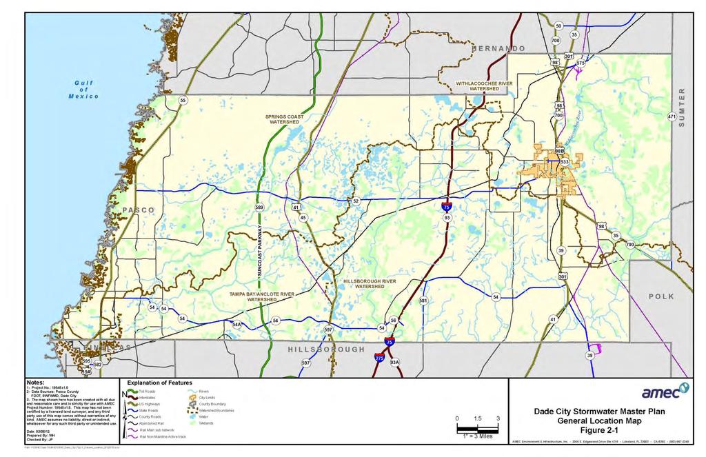
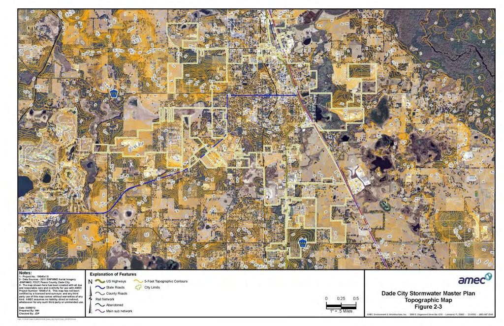
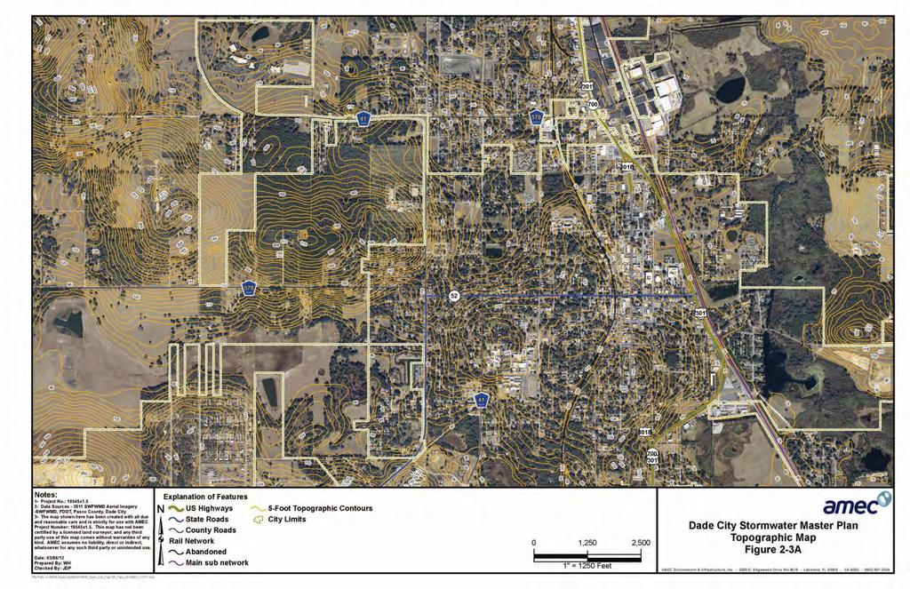
3 Page WATERSHED DESCRIPTION 2.1 Overview The City of Dade City incorporated limits include approximately 3920 acres or 6.1 square miles in eastern Pasco County (Figure 2-1). The vast majority of this area (except for a small portion at the extreme southern end) contributes to the Withlacoochee River Watershed (WRW) while the small section at the south end drains to the Hillsborough River Watershed (HRW). The area draining to HRW is an insignificant portion of the overall city s jurisdiction; does not experience any known drainage problems; and as such will not be discussed further in this report. The remainder of the city falls within the 40.2 square mile Duck Lake portion of the WRW. This Duck Lake area has been studied and modeled extensively by SWFWMD and is detailed in the District s 1987 s Duck Lake Stormwater Management Master Plan. Dade City is located approximately at the center of the Duck Lake basin, which generally extends from St. Leo and San Antonio to the west, across Highway US 98 to Duck Lake (southeast of Dade City) which then serves as one of several primary headwaters for the Withlacoochee River. The Duck Lake Master Plan watershed limits and the drainage basin delineations developed to perform the storm water analysis for this report are shown in Figure 2-2. Dade City contains a diversity of land use types but is primarily dominated by low and medium density residential, agricultural, wetlands, commercial and institutional land uses. The commercial and industrial areas are scattered throughout the city while the residential is generally concentrated in the north and west and the agricultural is primarily located in the south and the west sections of town. The watershed drains primarily from the high sand hills along the western side of town towards the east and into the low wetlands and marshes of the Withlacoochee River floodplain. Due to the rolling topography and limited drainage infrastructure, there are numerous closed drainage basins that have no surface discharge and many others that have a discharge conveyance that is no longer adequate to handle the stormwater rates and volumes generated under the City s current state of development. These two factors are primary sources of the flooding problems that are experienced by the City. Many of the closed drainage basins rely on natural percolation of the stormwater into the ground as their only discharge, whereas four of the closed basins utilize stormwater pumping stations to discharge the flood waters. Topography within the watershed varies from a high of over 200 feet North American Vertical Datum (NAVD 88) in the western sand hills to a low of 75 feet along US Highway 301/98 in the southern portions of the city as depicted in Figure 2-3 (Datum is NAVD 88). Topography is also depicted on 24 x 36 sheets, located in the pockets accompanying this report, as Figures 2-3A. All of the areas that have a surface discharge, with the exception of the small portion draining to the HRW, ultimately drain to the Withlacoochee River floodplain. That floodplain has a published 100-year flood elevation of approximately 78 feet National Geodetic Vertical Datum (NGVD 29) which corresponds approximately to 77.1 feet (NAVD 88). As confirmed by Figure 2-3 many areas in the eastern portions of the city are near or even below this elevation. The result is that even if drainage conveyances exist, they are of limited value during flood events
4 Page 14 because the flood elevation of the Withlacoochee River floodplain is higher than the ground elevations in these low portions of the city. The Withlacoochee River flood waters spill out into the floodplain eventually reaching the City limits. In conjunction with closed basins and limited drainage infrastructure discussed earlier, the high Withlacoochee River flood elevations (sometimes referred to as tailwater conditions) prove to be a major cause of flooding within the city. These issues will be discussed in more detail later in this report.
5 Page 15
6 Page 16
7 Page 17
8 Page 18
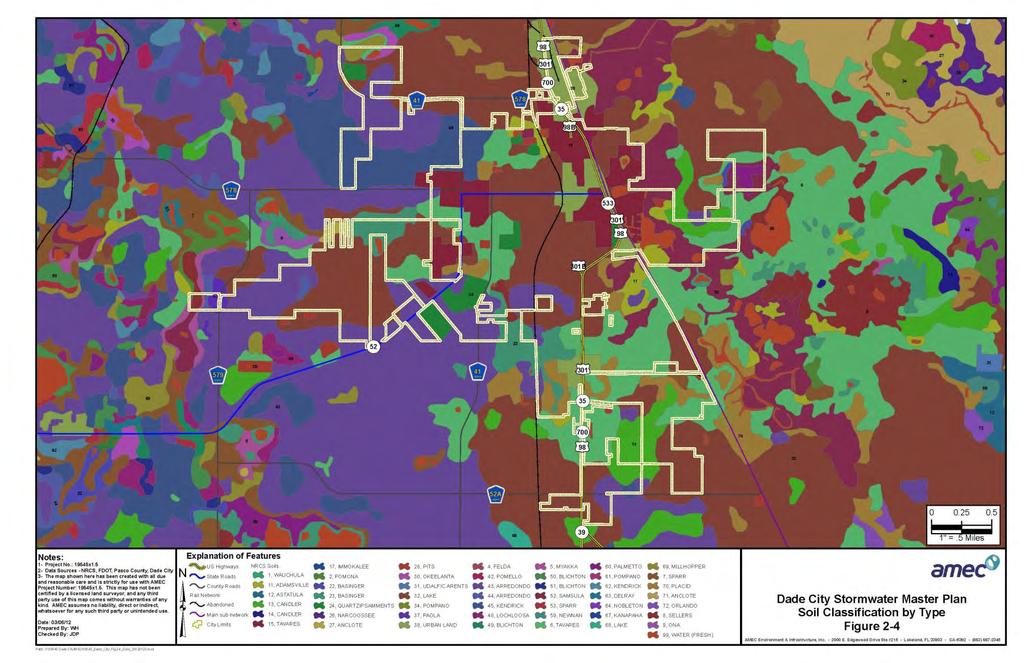
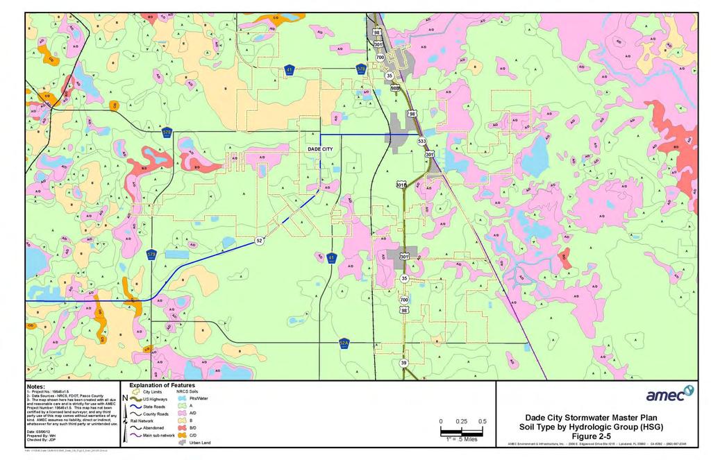
9 Page Climate The climate of the Dade City area, and for Pasco County as a whole, can be classified as humid subtropical. Annual average precipitation is around 55 inches with approximately 60% of the total occurring during the four-month rainy season that extends roughly from June through September. This rainy season also coincides with the occurrence of most tropical storms and hurricanes. The majority of the rain events are the ubiquitous convective afternoon and evening thunderstorms that occur regularly during the summer months. Individual storms tend to be localized, and are characteristically highly variable in both intensity and volume. These regular events tend to be of high intensity and short duration that typically lead to short term flooding that abates several hours after the event. Larger, longer duration storms such as hurricanes or tropical depressions can produce much heavier volumes of stormwater that tend to produce floodwaters that remain for days to weeks after the events. Current permitting requirements and construction codes dictate that larger storm water structures and conveyances be installed for new construction, but much of the older infrastructure present throughout the City of Dade City simply cannot accommodate the large rates and volumes of stormwater produced by regular summer storm events neither the less frequent tropical systems nor the typical daily thunderstorms. Winter season rainfall occurs less frequently than during the summer season and is usually less intense than the events occurring in the summer months. Winter rainfall is usually the result of cold fronts passing through the area and not due to strong convective storms. Primarily during El Nino years, the region does occasionally see large rainfall events in the winter dry season. The annual mean temperature in Pasco County is approximately 72 F (Fahrenheit). The average high temperature varies from a low of approximately 71 F in January to a high of approximately 91 F from June through August. Temperatures can but rarely do exceed 100 F. The average low temperatures vary from 49 F in January to 72 F in August. Winter temperatures can fall into the teens on several occasions each winter. Humidity during the summer months is consistently above 90% and somewhat lower in the winter, but generally is high year-round. Estimates of evapo-transpiration rates vary widely but are generally taken to be between 40 to 56 inches per year. 2.3 Soils Soil distribution is shown in both Figures 2-4, and 2-5. These data were developed based on Geographical Information Systems (GIS) coverages developed by SWFWMD. Many useful details and design considerations can be compiled from general knowledge of an area s soils and by consulting the USDA Soil Conservation Service s Pasco County Soils survey.
10 Page 20 Soil types are divided by the Soil Conservation Service (SCS) into four primary Hydrologic Soil Groups (HSG) A, B, C, and D - based on their runoff potential; the distribution of these types are shown in Figure 2-5. The hydrologic groups are utilized to reduce the dozens of distinct soil units into a smaller set of like soils that exhibit similar characteristics. The common characteristics of each HSG allow more accurate estimates of infiltration rates, moisture capacity, runoff generation and other general hydrologic properties of large areas without requiring site-specific soil borings and tests throughout the areas to be studied. For stormwater and drainage studies, the quantity of runoff that is generated during storm events is a crucial parameter. Various soil types and groups exhibit common and differing characteristics that greatly impact that quantity of runoff. Several of those characteristics are: depth to the seasonal high water level (SHWL), permeability and porosity of the soil reflecting grain size, slope of ground surface, and depth to a confining layer such as clay or hardpan that restricts the downward infiltration of storm water. The major soil hydrologic soil groups capture these parameters and are briefly described as: Group A soils have high infiltration rates and a correspondingly-low runoff potential rate when thoroughly wetted. They are typically deep, well-drained, large-grained sandy or gravelly soils with a high rate of water transmission. These soils typically have permeabilities on the order of 6 20 inches/hour and SHWL at six feet below grade or even deeper meaning that groundwater does not reach near the ground surface and the soils maintain their infiltrative capacity during the entire year. Representative soils types found in the Dade City watershed that fall into this group include (among others): Adamsville (11), Candler fine sand (13, 14), Tavares (6, 15), and Lake (32). Group B soils have moderate infiltration rates and a slightly greater runoff potential rate when thoroughly wetted than Group A. They are typically moderately deep, moderately well-drained, and fine to coarse-grained sandy soils with a moderate rate of water transmission. These soils typically also have permeabilities on the order of 6 20 inches/hour but often include intermittent layers of less permeable soils that restrict the overall water transmission capability. SHWL can range from at the surface to several feet below grade. These higher groundwater levels restrict the infiltrative capacity during the wet season. Representative soils types found in the Dade City watershed that fall into this group include (among others): Kendrick fine sand (45, 62). Group C have low infiltration rates and a much greater runoff potential rate when thoroughly wetted than either Group A or Group B. They are typically fine-grained sandy soils and/or may have intermittent layers of clay, hardpan or other restrictive layers that greatly diminish the rate of water transmission. The sandy portions of these soils typically have permeabilities less than 5 inches/hour but the restrictive layers effectively minimize even this water transmission capability. SHWL can range from at the surface to several feet
11 Page 21 below grade. These higher groundwater levels restrict the infiltrative capacity during the wet season. Oddly enough, there are no HSG C soils found in the Dade City watershed that fall into this group. Group D soils have very slow infiltration rates and a much greater runoff potential rate when thoroughly wetted than the other groups. They are typically composed of clays or muck (soils with high concentrations of decaying and decayed organic materials that impede water flow); have high groundwater levels (even exceeding the ground surface); contain restrictive layers at or near the surface and generally present a very slow rate of water transmission. These soils typically have no realistic permeability due to restrictive layers and existing water levels. SHWL typically exceeds the ground surface for extended periods of time throughout the year. Often soils are listed as A/D, B/D or C/D. These soils simply have characteristics of the two listed groups. The first group (A, B, or C) is how the soil would be described if it were improved, i.e. ditched or drained in some manor so that high groundwater levels were not a factor. The D symbolizes how the soil exists in its unimproved, natural condition. For hydrologic analysis, these soils are all treated as HSG D soils to reflect their existing condition in the field. Soil types that fall within the A/D classification found in the Dade City watershed include: Basinger (23), Samsula (52), and Placid (70). Urban Land (38) is simply a designation that regardless of the original soil type, the area is highly impervious due to development and as a result it is difficult to determine precisely what the natural soil might be and due to the high percentage of impervious surface the underlying soil type is of less importance. Quartzipsamments (24) is not assigned a true hydrologic soils group due to the highly disturbed nature of its mined soils. Soil types can also be differentiated as either hydric or non-hydric. Hydric soils are typically high in organics, typically are mucks or contain mucks, are inundated below water level for regular intervals every year, typically occur within natural depressions and as a result are usually within wetlands. These soils are all HSG D or one of the dual groups A/D, B/D, or C/D. Non-hydric soils are upland soils, are not regularly inundated, contain smaller amounts of organic material and typically are developed and exist in aerobic conditions.
12 Page 22
13 Page 23
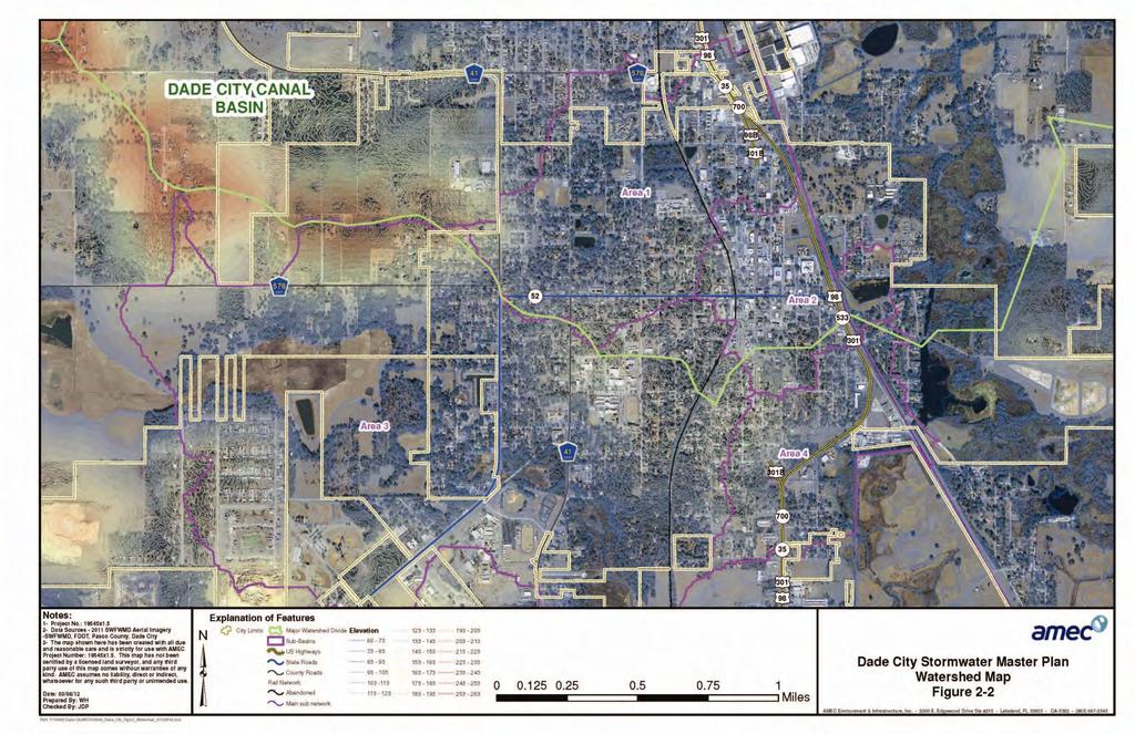
14 Page Physiography and Hydrology According to the SCS Soil Survey, the Dade City watershed lies within the Brooksville Ridge an area characterized by shallow sands, intermittent sinkholes, widely varying elevations from elevation 75± feet along US Highway 301/98 in Dade City to as high as elevation 300 feet on Clay Hill located just northwest of Dade City. The underlying strata are primarily Miocene sands and clay that have eroded at different rates to produce the characteristic hills and closed basins common throughout the area. These elevation patterns are shown on Figure 2-3. There is limited surface drainage from rainfall over undeveloped portions of the watershed and most of the flow is downward via infiltration. This infiltrated water can dissolve the underlying limestone and over time contributes to the undulating topography prevalent in the area. The surface flows that do exist are generally from the west to east toward the Green Swamp and the Withlacoochee River. The Green Swamp is a protected environmental system that provides the headwaters not only for the Withlacoochee River but also for the Hillsborough River and Palatlakaha River systems. Together, these two rivers are the dominant surface hydrologic features in this section of central Florida Watershed Sub-basins The primary watershed studied under this Master Plan for the City can be divided into four main areas or sub-basins as shown in Figure 2-2. The majority of chronic flooding problems have been reported in the locations designated as Area 1 and Area 2; therefore the flood model was developed in these two areas only. Area 1 is primarily the northern section of the city and contains many small closed drainage basins with no surface outfall but also includes large areas that ultimately drain easterly through multiple storm sewer conveyances to the existing lift station at the Cogen facility located on the east side of US Highway 98/301. From here the stormwater is pumped eastward to a wetland and ditched system referred to as the Dade City Canal and conveyed to the Withlacoochee River floodplain. Low lying portions of Area 1 are plagued by flooding which is experienced by residents via roadway flooding; yard flooding, and infrequent residential structure flooding. The area along 10 th Street and north of Whitehouse Avenue is simply lower than the surrounding areas and so stormwater naturally collects and ponds in this location. Section 3.1 of the report describes the drainage in more detail. Area 2 includes a densely developed portion of town and includes the highly impervious downtown area. The downtown area experiences frequent flooding due to the absence of a drainage conveyance system. Although the downtown area has seen an increase of imperviousness to over 80% or so, reliance on surface drainage has continued. The existing shallow roadway gutters easily flood from drainage from typical thunderstorm. The downtown area is discussed in more detail in Section 3.2 in the report. The proposed improvements to the downtown drainage system have already been submitted to the
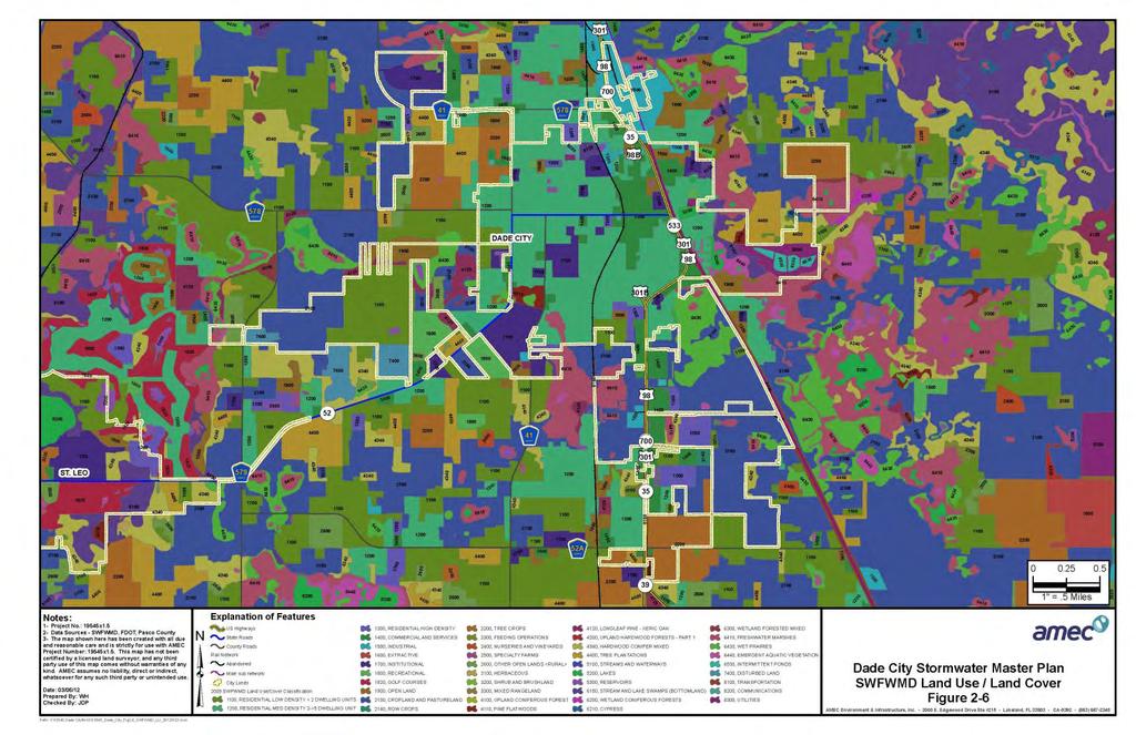
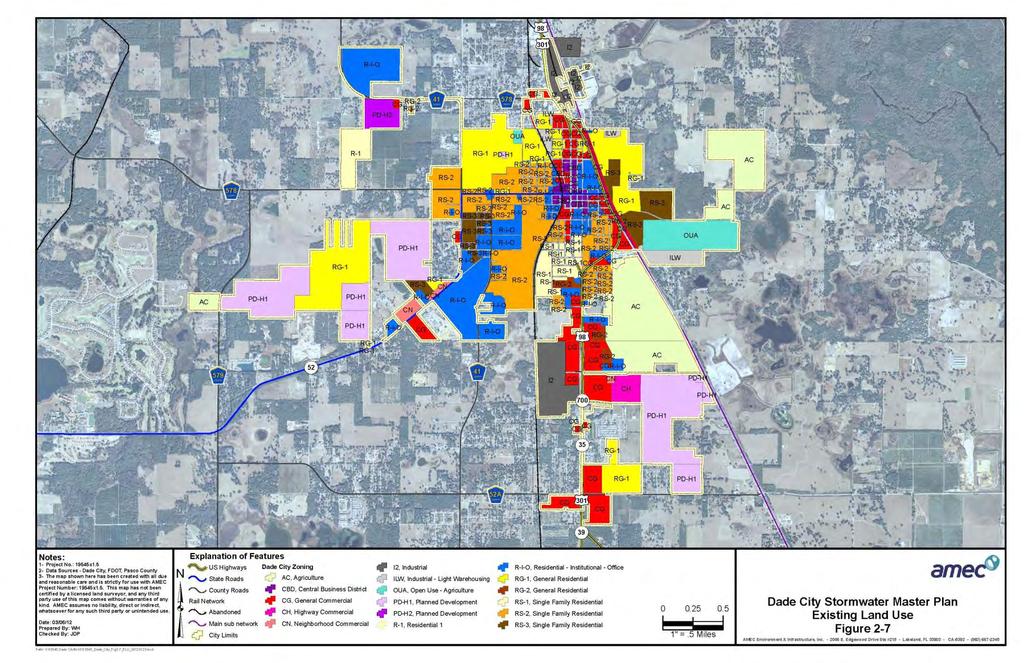
15 Page 25 Southwest Florida Water Management District (SWFWMD) and the Florida Department of Transportation (FDOT) for permitting. Area 3 is the southwestern portion of the City and generally is bordered by St. Joe Road (CR 578) on the north, 10 th Street on the east, Pasco High School complex on the south and The Pines subdivision on the west. This area is part of the larger Tank Lake Drainage Basin of Special Concern designated by the City in 2008 for special stormwater criteria. This sub-basin has several low lying areas that are closed basins or areas that are flood prone due to the lack of a surface discharge. Drainage from residential and commercial areas on the north side of Highway 52 collects in a low area located north of John Burks Memorial Park complex. Stormwater runoff from areas located east of Fort King Road collect in low lying areas inclusive of Hester Lake and Tank Lake. During extreme flood conditions, these two flood prone areas are connected at the confluence of Fort King Road, Old Saint Ann Road and Highway 52. There have been instances of flooding within this area although no specific structure flooding was reported during the preparation of this Master Plan. Area 4 is located in the east central portion of town and includes the intersection of 7 th Street and US 98 Bypass and the intersection of Old Lakeland Highway and US 98 Bypass. Surface water runoff from residential areas on the north side sheetflows to the south and east under US 98 Bypass into low lying flood prone areas. Drainage from these low areas discharge easterly under Old Lakeland Highway and flow to the north toward the Withlacoochee River floodplain. No structure flooding was noted for this area by City staff during the course of the Master Plan development. 2.5 Existing and Future Land Use Land use information was gathered from two primary sources. The existing land use was determined by using 2009 Southwest Florida Water Management District and Pasco County Comprehensive Plan information. The future land use information was acquired from the Pasco County Comprehensive Plan. Please note that the acreages in the two coverage s are slightly different as the future land use information reflects the up-to-date limits of acres while the existing land use data has not been completely updated and therefore the acreages refer primarily to the 3828 acres that comprise the city limits when those data were compiled in Existing Land Use Dade City contains a diversity of land use types but consists primarily of low and medium density residential (1148 acres), agricultural (1042 acres), wetlands (361 acres), commercial (294 acres) and institutional (248 acres) land uses. The Southwest Florida Water Management District s 2009 Land Use/Land Cover Map is shown in Figure 2-6. Additional existing land use information provided by the County s Property Appraiser s Office is illustrated in Figure 2-7. The most intensely developed land uses are in the east
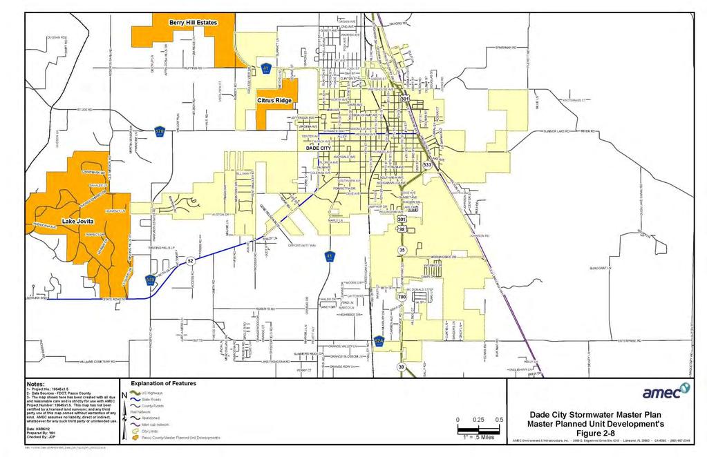
16 Page 26 central portion of the city around the main thoroughfare US Highway 98/301 and the adjacent CSX railroad facility. The majority of the developed areas commercial, industrial and residential - tend to be older construction and as such have little or no stormwater treatment or attenuation provided since state stormwater regulations were not in force until the early 1980 s. Many of the drainage problems have developed over the years as development reduced the available pervious surface area for stormwater to infiltrate into the ground and simultaneously increased the volume of stormwater produced from the basin area. The stormwater subsequently drained overland or through undersized storm sewers, conveyances and pumping systems that were not designed to handle the current level of stormwater volumes and rates generated from their contributing drainage areas. As shown in Figure 2-8, there are several Master Planned Unit Developments in the general area of the County but none within the study area for the City. Table 2.1 indicates that of the 3,920+ acres in the watershed within the city limits, approximately 2,012+ acres or 51.3% of the watershed has been developed, another 1,196+/- acres or 30.5% are agricultural, open or recreational, and the remaining 712 +/- acres are either natural areas or water/wetlands or unaccounted for in the existing land use code. Table 2.1 Existing Land Uses Dade City Area Watershed (Based on 2009 Southwest Florida Water Management District Information) Land Use Category Total Acreage Percent of Total Low / Medium Density Residential High Density Residential Industrial Agricultural Commercial Institutional Highway / Utility Recreational Open Land Extractive (Mining) / Disturbed Upland Forested Wetland Forested Wetland Non-Forested Water Undetermined TOTAL
17 Page 27
18 Page 28
19 Page 29
20 Page Future Land Uses Figure 2-9 shows the projected future land use map according to the Pasco County Comprehensive Plan. Due to the highly developed nature of the City watershed, not many significant changes in land use are predicted. The majority of predicted changes will be associated with the agricultural and open land areas and will most likely change over to a mixed urban use of residential and light commercial land uses. The names of the various categories have been changed and standardized but the general land uses have not been significantly changed (see Table 2.2). Table 2.2 Future Land Uses Dade City Area Watershed (Based on Pasco County Comprehensive Plan Information) Land Use Category Total Acreage Percent of Total Residential Residential Residential Residential/Office Retail/Office/Residential Light Industrial Heavy Industrial Public/Semi-Public Residential/Office/Retail General Commercial High-density Residential Low-density Residential Medium-density Residential Downtown Right of Way Major Recreation and Open Space Conservation/Preservation Unknown TOTAL
21 Page 31
Deep River-Portage Burns Waterway Watershed 2015
 2.4 Soils Soil development is the product of the interaction of parent material, topography, climate, organisms and time. Understanding the types of soils that exist within a watershed and their characteristics
4.1 General Methodology and Data Base Development
 Chapter 4 METHODOLOGY 4.1 General and Data Base Development This report project utilized several computer software models and analysis techniques to create the numeric data on which decisions for this
Mapping and Understanding YOUR LAKE S WATERSHED By: Tony Groves, Pam Tyning, and Tory Meyers Water Resources Group, Progressive AE
 By: Tony roves, Pam Tyning, and Tory Meyers Water Resources roup, Progressive A What is a Watershed? A watershed is the land area surrounding a lake from which water drains to the lake. The imaginary line
To: From: Date: Subject: Sherwood Lakes Drainage Alternatives Analysis 1
 To: From: The City of Virginia Beach Lewis White and Rachael Johnson on behalf of WSP Date: June 6, 2017 Subject: s Drainage Alternatives Analysis This memorandum represents the summary of findings from
LAKE COUNTY HYDROLOGY DESIGN STANDARDS
 LAKE COUNTY HYDROLOGY DESIGN STANDARDS Lake County Department of Public Works Water Resources Division 255 N. Forbes Street Lakeport, CA 95453 (707)263-2341 Adopted June 22, 1999 These Standards provide
LOWER SWEETWATER CREEK
 LOWER SWEETWATER CREEK STORMWATER MANAGEMENT MASTER PLAN Prepared for the Hillsborough County Board of County Commissioners By Public Works Department/Engineering Division Stormwater Management Section
6.0 Runoff. 6.1 Introduction. 6.2 Flood Control Design Runoff
 October 2003, Revised February 2005 Chapter 6.0, Runoff Page 1 6.1 Introduction 6.0 Runoff The timing, peak rates of discharge, and volume of stormwater runoff are the primary considerations in the design
Instructions for Notice of Ground Disturbance Form:
 Instructions for Notice of Ground Disturbance Form: Prior to beginning any ground disturbance activity or finalizing your storm water plan, submit a completed 2 page Notice of Ground Disturbance Form to
Watershed Delineation Techniques
 Watershed Delineation Techniques Stacy D. Dehne DATCP Engineer February 2008 1 What Is a Watershed? An Area of Land that Drains to a given location February 2008 2 Contour Map Features Contour Maps: Represent
INFRASTRUCTURE ELEMENT/NATURAL GROUNDWATER AQUIFER RECHARGE SUB-ELEMENT
 I. INTRODUCTION A. Purpose As provided in this Natural Groundwater Aquifer Recharge Sub-element, the City of Ocoee has developed guidelines based on the St. Johns River Water Management District s programs.
Names: ESS 315. Lab #6, Floods and Runoff Part I Flood frequency
 Names: ESS 315 Lab #6, Floods and Runoff Part I Flood frequency A flood is any relatively high flow of water over land that is not normally under water. Floods occur at streams and rivers but can also
CHAPTER 7 PHYSICAL INVENTORY OF THE CITY
 CHAPTER 7 PHYSICAL INVENTORY OF THE CITY Chapter 7: Physical Inventory of the City 39 This page intentionally left blank. Chapter 7: Physical Inventory of the City 40 SECTION 1 PHYSICAL SETTING While communities
STORMWATER MANAGEMENT REPORT FOR TAVARES EAST DISTRIBUTION SUBSTATION
 STORMWATER MANAGEMENT REPORT FOR TAVARES EAST DISTRIBUTION SUBSTATION (Lake County, Florida, Section 29, Township 19S, Range 26E) Prepared by: Duke Energy Florida, Inc. 3300 Exchange Place NP3A Lake Mary,
3F. Hydrology and Water Quality
 This section provides an analysis of potential hydrological and water quality impacts associated with implementation of the proposed project. The section also evaluates and describes the potential impacts
PEARCE CREEK CONFINED DISPOSAL AREA MODIFICATION
 US Army Corps of Engineers Philadelphia District PEARCE CREEK CONFINED DISPOSAL AREA MODIFICATION CECIL COUNTY MARYLAND STORMWATER MANAGEMENT PLAN NARRATIVE INITIAL SUBMISSION JUNE 2014 1 PEARCE CREEK
Stormwater Analysis Report
 Stormwater Analysis Report Solar Panel Array Temple Street (Rt. 14) West Boylston, MA February 24, 216 SITE Prepared for: West Boylston Municipal Lighting Plant 4 Crescent Street West Boylston, MA 1583
REFERENCE MAPS FEMA FIRM MAP NRCS SOILS MAP
 REFERENCE MAPS FEMA FIRM MAP NRCS SOILS MAP Hydrologic Soil Group-Hillsborough County, Florida (Independence Parkway) 27' 58' 56" 27" 58' 57" 2r 58' 32" 27" 58' 33" Map Scale: 1:5,290 if printed on A size
Stormwater Erosion Control & Post-Construction Plans (Stormwater Quality Plans)
") Stormwater Erosion Control & Post-Construction Plans (Stormwater Quality Plans) Allen County Stormwater Plan Submittal Checklist The following items must be provided when applying for an Allen County Stormwater
Stormwater Erosion Control & Post-Construction Plans (Stormwater Quality Plans) Allen County Stormwater Plan Submittal Checklist The following items must be provided when applying for an Allen County Stormwater
APPENDIX E APPENDIX E ESTIMATING RUNOFF FOR SMALL WATERSHEDS
 APPENDIX E ESTIMATING RUNOFF FOR SMALL WATERSHEDS March 18, 2003 This page left blank intentionally. March 18, 2003 TABLES Table E.1 Table E.2 Return Frequencies for Roadway Drainage Design Rational Method
COON CREEK WATERSHED DISTRICT PERMIT REVIEW Mississippi Dr Coon Rapids, MN SQ FT Residence on 0.64 Acre Lot
 17-082 Van Sloun Residence, Page 1 of 5 COON CREEK WATERSHED DISTRICT PERMIT REVIEW MEETING DATE: May 8, 2017 AGENDA NUMBER: 17 FILE NUMBER: 17-082 ITEM: Van Sloun Residence RECOMMENDATION: Approve with
Chapter 2: Conditions in the Spring Lake Watershed related to Stormwater Pollution
 Chapter 2: Conditions in the Spring Lake Watershed related to Stormwater Pollution To identify the primary causes and consequences of stormwater discharges to Spring Lake and its adjoining waterbodies,
LOCATION HYDRAULICS REPORT. SR 60 GRADE SEPARATION AT CSX RAILROAD PROJECT DEVELOPMENT AND ENVIRONMENT STUDY Polk County, Florida
 LOCATION HYDRAULICS REPORT SR 60 GRADE SEPARATION AT CSX RAILROAD PROJECT DEVELOPMENT AND ENVIRONMENT STUDY Polk County, Florida Financial Project ID: 436559-1-22-01 Prepared for: FLORIDA DEPARTMENT OF
Sea Level Rise and Recurrent Flooding Update
 Sea Level Rise and Recurrent Flooding Update Informational Briefing City Council Meeting September 18, 2018 Thomas M. Leahy, Deputy City Manager The Sea, Inland Waters, & Groundwater are Rising Projected
acquiring, managing, and disposing of federal lands and facilities;
 2.2.1 HYDROLOGY AND FLOODPLAIN This section discusses and analyzes the surface hydrology and water quality characteristics of the project. The information provided in this section is based on the Preliminary
APPENDIX E ESTIMATING RUNOFF FROM SMALL WATERSHEDS
 ESTIMATING RUNOFF FROM SMALL WATERSHEDS June 2011 THIS PAGE LEFT BLANK INTENTIONALLY. June 2011 TABLES Table E.1 Table E.2 Return Frequencies for Roadway Drainage Design Rational Method Values June 2011
4.2 Cherry Creek & Stillhouse Branch
 Section 4 Withlacoochee Basin 4.2 Cherry Creek & Stillhouse Branch 4.2.1 Introduction The information presented in this sub-basin plan for Cherry Creek and Stillhouse Branch is intended to provide the
Chapter 6. Hydrology. 6.0 Introduction. 6.1 Design Rainfall
 6.0 Introduction This chapter summarizes methodology for determining rainfall and runoff information for the design of stormwater management facilities in the City. The methodology is based on the procedures
Chapter 3 Previous Studies
 Chapter 3 Previous Studies The Vista Grande stormwater conveyance system and watershed area has been evaluated in a number of reports and studies for the CCSF, the Daly City and San Mateo County over the
PRELIMINARY DRAINAGE STUDY
 PRELIMINARY DRAINAGE STUDY For 34 th & J Residences 3402 J St. San Diego, CA 92102 A.P.N 545-250-08 Prepared By: Kenneth J. Discenza, P.E. Site Design Associates, Inc. 1016 Broadway, Suite A El Cajon,
CRYSTAL LAKE FLOODING STUDY EXECUTIVE SUMMARY
 Project #08223 CRYSTAL LAKE FLOODING STUDY EXECUTIVE SUMMARY PREPARED FOR: City of Crystal Lake 100 West Woodstock Street Crystal Lake, Illinois 60014 FEBRUARY 11, 2009 26575 W. COMMERCE DRIVE, SUITE 601,
4.1 Browns Canal Introduction Sub-basin Information
 Section 4 Withlacoochee Basin 4.1 Browns Canal 4.1.1 Introduction The information presented in this sub-basin plan for Browns Canal is intended to provide the reader with information necessary to understand
APPENDIX J-3. Orcem Stormwater Management and Treatment Facilities Design Summary
 APPENDIX J-3 Orcem Stormwater Management and Treatment Facilities Design Summary Stormwater Management & Treatment Facilities Design Summary INTRODUCTION KPFF Consulting Engineers has compiled this report
Background. Literature Review
 Ms. Joanna Helms Economic Development Director Town of Apex 73 Hunter Street P.O. Box 250 Apex, North Carolina 27502 October 23, 2015 Reference: Report of Wetland Determination Cash Perkins Site ECS Project
11. Public Utilities. Key Terminology: OVERVIEW STORMWATER MANAGEMENT WATERSHED MANAGEMENT ORGANIZATIONS AND COMMISSIONS. Inventory and Analysis
 Inventory and Analysis 11. Public Utilities Urbanized (drainage): Defined as an area where natural soils, waterways, and environmental functions are replaced with impervious surfaces (roads, parking lots,
Stormwater Local Design Manual For Houston County, Georgia
 Stormwater Local Design Manual For Houston County, Georgia Adopted November 15, 2005 TABLE OF CONTENTS 1. FORWARD... 1 2. GENERAL LEVEL OF SERVICE STANDARDS... 2 2.1. DETENTION REQUIREMENTS... 2 2.1.1.
RUBONIA SUBDIVISION DRAINAGE AND ROADWAY IMPROVMENTS PREPARED BY: MANATEE COUNTY PUBLIC WORKS ENGINEERING SERVICES DIVISION
 RUBONIA SUBDIVISION DRAINAGE AND ROADWAY IMPROVMENTS PREPARED BY: MANATEE COUNTY PUBLIC WORKS ENGINEERING SERVICES DIVISION OCTOBER 7, 2016 1 INTRODUCTION Rubonia Neighborhood (Rubonia) is located in northern
CHAPTER 4 - EROSION & SEDIMENT CONTROL AND STORMWATER MANAGEMENT ORDINANCE OF DUBUQUE COUNTY, IOWA. Adopted March 29, 2010.
 CHAPTER 4 - EROSION & SEDIMENT CONTROL AND STORMWATER MANAGEMENT ORDINANCE OF DUBUQUE COUNTY, IOWA Adopted March 29, 2010 Table of Contents Page Part 1 Introduction...3 4-1 Title..................3 4-2
August 15, 2006 (Revised) July 3, 2006 Project No A
 July 3, 2006 Project No A") August 15, 2006 (Revised) July 3, 2006 Project No. 01-05-0854-101A Mr. David Reed, P.E. Protean Design Group 100 East Pine Street, Suite 306 Orlando, Florida 32801 Preliminary Soil Survey Report Polk Parkway
August 15, 2006 (Revised) July 3, 2006 Project No. 01-05-0854-101A Mr. David Reed, P.E. Protean Design Group 100 East Pine Street, Suite 306 Orlando, Florida 32801 Preliminary Soil Survey Report Polk Parkway
The Town of Chester Stormwater Mapping Report
 The Town of Chester Stormwater Mapping Report Prepared by the Warren County Soil & Water Conservation District December 2013 Table of Contents Introduction and Location 3 Stormwater Runoff 3 Assessment
INFLOW DESIGN FLOOD CONTROL SYSTEM PLAN PLANT GREENE COUNTY ASH POND ALABMA POWER COMPANY
 INFLOW DESIGN FLOOD CONTROL SYSTEM PLAN PLANT GREENE COUNTY ASH POND ALABMA POWER COMPANY Section 257.82 of EPA s regulations requires the owner or operator of an existing or new CCR surface impoundment
Public Works and Engineering
 6.C Exhibit Incorporated in 1909 Public Works and Engineering Committee Report To: From: Mayor and Board of Trustees Bill Emmerich For Village Board Meeting of: November 27, 2017 Subject: Division and
PRELIMINARY DRAINAGE REPORT NEWCASTLE FIRE STATION OLD STATE HIGHWAY
 PRELIMINARY DRAINAGE REPORT FOR THE NEWCASTLE FIRE STATION OLD STATE HIGHWAY PREPARED FOR THE NEWCASTLE FIRE PROTECTION DISTRICT JULY 2014 BY ROSEVILLE DESIGN GROUP, INC. ROSEVILLE DESIGN GROUP, Inc Established
MODEL Stormwater Local Design Manual. City of Centerville
 MODEL Stormwater Local Design Manual City of Centerville Adopted December 6, 2005 TABLE OF CONTENTS 1. FORWARD... 1 2. GENERAL LEVEL OF SERVICE STANDARDS... 1 2.1. DETENTION REQUIREMENTS... 1 2.1.1. Discharge
Chapter Introduction. 5.2 Computational Standard Methods HYDROLOGY
 Chapter 5. HYDROLOGY 5.1 Introduction The definition of hydrology is the scientific study of water and its properties, distribution, and effects on the earth s surface, in the soil and the atmosphere.
Preliminary Drainage Analysis
 Preliminary Drainage Analysis Tanimura and Antle Employee Housing Town of Spreckels County of Monterey, California LIB150205 May 29, 2015 Prepared For: Tanimura and Antle Produce Prepared By: 9699 Blue
COON CREEK WATERSHED DISTRICT PERMIT REVIEW. Spring Lake Park Schools Westwood Middle School st Avenue NE, Spring Lake Park, MN 55432
 PAN 16-112, Westwood Middle School, Page 1 of 6 COON CREEK WATERSHED DISTRICT PERMIT REVIEW MEETING DATE: August 22, 2016 AGENDA NUMBER: 10 FILE NUMBER: 16-112 ITEM: Westwood Middle School RECOMMENDATION:
Infiltration Guidelines
 Appendix E Infiltration Guidelines As a stormwater management method, infiltration means retaining or detaining water within soils to reduce runoff. Infiltration can be a cost-effective method to manage
CENTRAL COAST POST-CONSTRUCTION REQUIREMENTS IMPLEMENTATION GUIDANCE SERIES 1
 CENTRAL COAST POST-CONSTRUCTION REQUIREMENTS IMPLEMENTATION GUIDANCE SERIES 1 SERIES ISSUE #2: DECENTRALIZED STORMWATER MANAGEMENT TO COMPLY WITH RUNOFF RETENTION POST-CONSTRUCTION STORMWATER CONTROL REQUIREMENTS
III. INVENTORY OF EXISTING FACILITIES
 III. INVENTORY OF EXISTING FACILITIES Within the Growth Management Boundary, the existing storm drainage facilities are largely associated with development that has historically occurred in the ten drainage
CHAPTER FIVE INFRASTRUCTURE ELEMENT
 CHAPTER FIVE INFRASTRUCTURE ELEMENT DRAINAGE SUBELEMENT Updated: EAR BASED AMENDMENTS July 11, 2006, Ord. No. 2006-A12 December 11, 2007, Ord. No. 2007-A37 (Sanitary Sewer Sub-element) September 16, 2008,
Fort Collins Amendments to the Urban Drainage and Flood Control District Criteria Manual
 Fort Collins Amendments to the Urban Drainage and Flood Control District Criteria Manual Fort Collins Amendments to the Urban Drainage and Flood Control District Criteria Manual, adopted by the City Council
Warner Robins Stormwater Local Design Manual
 Warner Robins Stormwater Local Design Manual Prepared for Houston County City of Warner Robins City of Perry City of Centerville May 17, 2005 Version 4 (As presented with adopted Stormwater Ordinance)
UNIVERSITY OF OREGON NORTH CAMPUS CONDITIONAL USE PERMIT PROJECT Draft Conditional Use Permit Stormwater, Sanitary Sewer, and Water Analysis Report
 UNIVERSITY OF OREGON NORTH CAMPUS CONDITIONAL USE PERMIT PROJECT Draft Conditional Use Permit Stormwater, Sanitary Sewer, and Water Analysis Report Prepared for: Cameron McCarthy Landscape Architects LLP
Dry Creek Flood Control Improvement Project
 Dry Creek Flood Control Improvement Project The following is a brief overview of the planned IRWM Stormwater Flood Management Grant Application from the Fresno Metropolitan Flood Control District (FMFCD)
THE EFFECTS OF URBANIZATION ON THE MINGO CREEK WATERSHED
 THE EFFECTS OF URBANIZATION ON THE MINGO CREEK WATERSHED by Tim Marshall (presented at the Sixth Conference on Hydrometeorology in Indianapolis, IN, 1984) 1. INTRODUCTION Urbanization of flood plains presents
City of Elmhurst Comprehensive Flood Plan Golden Meadows Park Flood Storage Facility
 December 16, 2014 City of Elmhurst Comprehensive Flood Plan Golden Meadows Park Flood Storage Facility Prepared by CBBEL Project Background & Timeline June and July 2010 Severe storm events hit Elmhurst,
THE CITY OF THE VILLAGE PLANNED UNIT DEVELOPMENT DESIGN STATEMENT FOR MULFORD ESTATES
 THE CITY OF THE VILLAGE PLANNED UNIT DEVELOPMENT DESIGN STATEMENT FOR MULFORD ESTATES Revised August 18, 2016, August 10, 2016, September 19,2016 Prepared By: Isch and Associates, Inc. 14848 Bristol Park
Appendix G Preliminary Hydrology Study
 Appendix G Preliminary Hydrology Study Preliminary Hydrology Study VESTING TTM 72608 Long Beach, CA Prepared for: The Long Beach Project, LLC 888 San Clemente, Suite 100 New Port Beach, CA May 28, 2014
Goals, Objectives, and Policies Infrastructure Element Introduction
 Goals, Objectives, and Policies Infrastructure Element Introduction Pursuant to Section 163.3177 (6) (c), FS and Sections 9J-5.011 (2)(b) and (c), FAC, the following represents the Potable Water, Sanitary
DRAINAGE AND NATURAL AQUIFER GROUNDWATER RECHARGE ELEMENT
 Goal 7.0. To optimize integrated stormwater management in order to reduce damage and impacts from sea level rise and flooding, promotes recharge to the Surficial Aquifer System (SAS), improve and protect
McColl Fence Addition GEOTECHNICAL ASSESSMENT
 McColl Fence Addition GEOTECHNICAL ASSESSMENT Prepared For: Stuart McColl 1038 Hooker Road Sequim, WA 98382 SEPTEMBER 2012 Prepared By: Trent T. Adams, EIT Justin C. Wilson, PE NTI ENGINEERING & LAND SURVEYING
Appendix A Stormwater Site Plan Report Short Form
 Appendix A Stormwater Site Plan Report Short Form The Stormwater Site Plan Report Short Form may be used for projects that trigger only Minimum Requirements #1-#5. These projects typically fall within
C o m p r e h e n s i v e P l a n S Y S T E M S
 C ii t y o f L u f k ii n C o m p r e h e n s i v e P l a n 2 0 0 1 I N F R A S T R U C T U R E S Y S T E M S INTRODUCTION The City of Lufkin operates and maintains an extensive water treatment and distribution
Attachment 12 Stage 1 Flood Risk Assessment (IE RP-0001)
") IE0311133-22-RP-0001, Issue A 17/10/2013 Attachment 12 Stage 1 Flood Risk Assessment (IE0311133-30-RP-0001) IE0311133-22-RP-0001_A_02.DOC Flood Risk Assessment Celebrating 40 Years in Business Jazz Pharmaceuticals
IE0311133-22-RP-0001, Issue A 17/10/2013 Attachment 12 Stage 1 Flood Risk Assessment (IE0311133-30-RP-0001) IE0311133-22-RP-0001_A_02.DOC Flood Risk Assessment Celebrating 40 Years in Business Jazz Pharmaceuticals
SILVER/TWIN LAKE WATERSHED MANAGEMENT PLAN EXECUTIVE SUMMARY
 SILVER/TWIN LAKE WATERSHED MANAGEMENT PLAN EXECUTIVE SUMMARY The Silver / Twin Lakes watershed drains approximately 0.8 square miles of land located in central Hillsborough County. The watershed is generally
DRAINAGE REPORT. Project Name: PG&E Gas Operations Technical Training Center Winters, CA. Date: February 4, Prepared by: BKF Engineers
 DRAINAGE REPORT Project Name: PG&E Gas Operations Technical Training Center Winters, CA Date: February 4, 2015 Prepared by: BKF Engineers Client: Pacific Gas & Electric Company This report has been prepared
ENVIRONMENTAL RESOURCE PERMIT APPLICATION
 ENVIRONMENTAL RESOURCE PERMIT APPLICATION SOUTHWEST FLORIDA WATER MANAGEMENT DISTRICT 2379 BROAD STREET, BROOKSVILLE, FL 34604-6899 (352) 796-7211 OR FLORIDA WATS 1 (800) 423-1476 SECTION E INFORMATION
Section 2: Watershed Characteristics and Runoff
 Section 2: Watershed Characteristics and Runoff The hydrology of the Wissahickon Creek and its tributaries varies greatly from place to place within the larger watershed. Stormwater management planning
Environmental Resource Inventories. What are ERIs? Significance of information How to use them
 Environmental Resource Inventories What are ERIs? Significance of information How to use them Environmental Resource Inventory - ERI Compiled by the environmental commission Information about the natural
AS A COURTESY, PLEASE TURN OFF CELL PHONES AND PAGERS WHILE MEETING IS IN PROGRESS.
 Table of Contents Agenda 2 Wastewater Treatment Plant (WWTP) Hydraulic Capacity Update Staff Report 3 WWTP Capacity Outline 5 WWTP Capacity Charts 6 Drainage Concerns on Oak Hill Drive and Quail Drive
Introduction STORMWATER SYSTEM ENHANCEMENT RECOMMENDATIONS
 Introduction During the early morning hours on Wednesday, September 24, 2014, the City of South Daytona received over six inches of rain which caused several streets to flood. In addition, there were six
City of Katy Flood Protection Study (Meeting 3 of 3) October 23, 2017
 October 23, 2017") City of Katy Flood Protection Study (Meeting 3 of 3) October 23, 2017 Phasing of Meetings April Meeting May Meeting October Review of Tax Day Storm Event and Immediate Actions Taken By City Review of Coordination
City of Katy Flood Protection Study (Meeting 3 of 3) October 23, 2017 Phasing of Meetings April Meeting May Meeting October Review of Tax Day Storm Event and Immediate Actions Taken By City Review of Coordination
SW-74 SERENOVA PRESERVE SITES 2, 3, 4, 8 MITIGATION PLAN
 SW-74 SERENOVA PRESERVE SITES 2, 3, 4, 8 MITIGATION PLAN BACKGROUND INFORMATION Project SWIM? Aquatic Control? Exotic Control? Mitigation Bank? Type No No No No Mitigation Restoration and enhancement Type
Planning Considerations for Stormwater Management in Alberta. R. D. (Rick) Carnduff, M. Eng., P. Eng. February 20, 2013.
 Carnduff, M. Eng., P. Eng. February 20, 2013.") Planning Considerations for Stormwater Management in Alberta R. D. (Rick) Carnduff, M. Eng., P. Eng. February 20, 2013 Photo Optional Purpose The purpose of urban stormwater management is to provide solutions
Planning Considerations for Stormwater Management in Alberta R. D. (Rick) Carnduff, M. Eng., P. Eng. February 20, 2013 Photo Optional Purpose The purpose of urban stormwater management is to provide solutions
BAEN 673 / February 18, 2016 Hydrologic Processes
 BAEN 673 / February 18, 2016 Hydrologic Processes Assignment: HW#7 Next class lecture in AEPM 104 Today s topics SWAT exercise #2 The SWAT model review paper Hydrologic processes The Hydrologic Processes
Isle of Wight Strategic Flood Risk Assessment MK2. Appendix E West Wight
 Isle of Wight Strategic Flood Risk Assessment MK2 Appendix E June 2010 Isle of Wight Strategic Flood Risk Assessment Overview The RDA is comprised of the towns of Totland and Freshwater and is classified
SECTION 3 NATURAL RESOURCES
 SECTION 3 NATURAL RESOURCES The natural environment plays a large role in planning for future development. Environmental conditions, such as topography, wetlands, floodplains, and water bodies, can often
Introduction to Storm Sewer Design
 A SunCam online continuing education course Introduction to Storm Sewer Design by David F. Carter Introduction Storm sewer systems are vital in collection and conveyance of stormwater from the upstream
NEW CASTLE CONSERVATION DISTRICT. through. (Name of Municipality) PLAN REVIEW APPLICATION DRAINAGE, STORMWATER MANAGEMENT, EROSION & SEDIMENT CONTROL
 PLAN REVIEW APPLICATION DRAINAGE, STORMWATER MANAGEMENT, EROSION & SEDIMENT CONTROL") NEW CASTLE CONSERVATION DISTRICT through (Name of Municipality) PLAN REVIEW APPLICATION DRAINAGE, STORMWATER MANAGEMENT, EROSION & SEDIMENT CONTROL Office use only: Received by Municipality: Received by
NEW CASTLE CONSERVATION DISTRICT through (Name of Municipality) PLAN REVIEW APPLICATION DRAINAGE, STORMWATER MANAGEMENT, EROSION & SEDIMENT CONTROL Office use only: Received by Municipality: Received by
The City of Cocoa (City) is located in east
 is located in east") FWRJ Reclaimed Water and Stormwater: A Perfect Pair to Meet Total Maximum Daily Load Wasteload Allocations? Danielle Honour, James Wittig, John A. Walsh, and Don Stevens Danielle Honour, P.E., D.WRE, and
FWRJ Reclaimed Water and Stormwater: A Perfect Pair to Meet Total Maximum Daily Load Wasteload Allocations? Danielle Honour, James Wittig, John A. Walsh, and Don Stevens Danielle Honour, P.E., D.WRE, and
APPENDIX A. Hydraulic Investigations: Cascade Mall at Burlington
 APPENDIX A m SUMMARY REPORT FOR E.I.S. Hydraulic Investigations: Cascade Mall at Burlington July 12, 1982 John E. Norman, P.E. 14779 Northeast 32nd, #A201 Bellevue, WA 98007 (206) 882-1767 92 General A
Characteristics of Land Resources
 Chapter Chapter 1 Characteristics of Land Resources The geology, soils and topography of Woodford County T he geology, soils and topography of an area are important to the community planning process for
SAMPLE DRAINAGE STATEMENT
 Firm Name & Logo Hidalgo County Drainage District No. 1 Drainage Statement Subdivision Name Hidalgo County, Texas Prepared By: Firm's Name Address City, State, Zip Telephone Fax Email Date SAMPLE DRAINAGE
9.0 General Infrastructure Element
 9.0 PURPOSE The purpose of this element is to ensure adequate provision of public facilities and services required to meet the future needs of the University, including the following: a) Ensure provision
IV. ENVIRONMENTAL IMPACT ANALYSIS G. HYDROLOGY/WATER QUALITY
 IV. ENVIRONMENTAL IMPACT ANALYSIS G. HYDROLOGY/WATER QUALITY ENVIRONMENTAL SETTING The project site is located in the Wilshire community of the City of Los Angeles and is bound by S. Wetherly Drive to
Stantec LAKEW OD RANCH STEWARDSHIP DISTRICT MASTER ENGINEER'S REPORT FOR NORTHEAST SECTOR AT LAKEWOOD RANCH INFRASTRUCTURE IMPROVEMENTS
 LAKEW OD RANCH STEWARDSHIP DISTRICT MASTER ENGINEER'S REPORT FOR NORTHEAST SECTOR AT LAKEWOOD RANCH INFRASTRUCTURE IMPROVEMENTS Stantec Prepared for: Lakewood Ranch Stewardship District 14400 Covenant
DICKINSON BAYOU WATERSHED STEERING COMMITTEE FINAL MEMBER CRITERIA COMPARISON
 DICKINSON BAYOU WATERSHED STEERING COMMITTEE FINAL MEMBER CRITERIA COMPARISON May 25, 2006 INTRODUCTION The Dickinson Bayou Watershed covers approximately 95.5 square miles and stretches from western Brazoria
Appendix 10-A. Optional Recharge Volume Approach
 Appendix 10-A Optional Recharge Volume Approach Table of Contents APPENDIX SECTION HEADINGS 10-A.0 INTRODUCTION 10-A-2 10-A.1 Horsely Method for Determining Recharge Volumes 10-A-2 10-A.1.1 Basis for Determining
CUYAHOGA COUNTY ENGINEER
 CUYAHOGA COUNTY ENGINEER DRAINAGE MANUAL Supplement to O.D.O.T. LOCATION and DESIGN MANUAL, Volume 2, Drainage Design, Section 1000 and 1100 May 28, 2010 Revisions to the July 29, 2009 edition are noted
Memorandum. Executive Summary
 277 Bendix Road Suite 300 Virginia Beach, VA 23452 Main: 757-466-1732 Fax: 757-466-1493 Memorandum To: The City of Virginia Beach From: Lewis White and Rachael Johnson on behalf of WSP Parsons Brinckerhoff
ZONING ORDINANCE FOR THE ZONED UNINCORPORATED AREAS ARTICLE 1500 OF PUTNAM COUNTY, WEST VIRGINIA Page 149 ARTICLE 1500 DRAINAGE AND STORM SEWERS
 OF PUTNAM COUNTY, WEST VIRGINIA Page 149 ARTICLE 1500 DRAINAGE AND STORM SEWERS 1500.01 GENERAL REQUIREMENTS 1500.02 NATURE OF STORM WATER FACILITIES 1500.03 DRAINAGE EASEMENTS 1500.04 STORM WATER MANAGEMENT
Practices that capture and temporarily store the WQ v before allowing it to infiltrate into the soil.
 Chapter 5: Acceptable Stormwater Management Practices (SMPs) This section presents a list of practices that are acceptable for water quality treatment. The practices on this list are selected based on
Municipal Stormwater Management Plan Prepared For The Borough of Cape May Point By Van Note-Harvey Associates VNH File No.
 Municipal Stormwater Management Plan Prepared For The Borough of Cape May Point By Van Note-Harvey Associates 2005 VNH File No. 35317-210-21 Table of Contents Introduction... 3 Goals... 3 Storm water Discussion...
Review Zone Application for D&R Canal Commission Decision
 Review Zone Application for D&R Canal Commission Decision MEETING DATE: January 18, 2017 DRCC #: 16-3020C Latest Submission Received: January 10, 2016 Applicant: PVP Franklin, LLC 769 Northfield Avenue,
INFLOW DESIGN FLOOD CONTROL SYSTEM PLAN PLANT GASTON GYPSUM POND ALABAMA POWER COMPANY
 INFLOW DESIGN FLOOD CONTROL SYSTEM PLAN PLANT GASTON GYPSUM POND ALABAMA POWER COMPANY Section 257.82 of EPA s regulations requires the owner or operator of an existing or new CCR surface impoundment or
City of Robbinsdale, Minnesota Storm Water Pollution Prevention Plan (SWPPP)
") City of Robbinsdale, Minnesota Storm Water Pollution Prevention Plan (SWPPP) 2006-2010 Adopted by City Council April 15, 2003 Amended for re-issuance of permit May 2006 Introduction The City of Robbinsdale
City of Robbinsdale, Minnesota Storm Water Pollution Prevention Plan (SWPPP) 2006-2010 Adopted by City Council April 15, 2003 Amended for re-issuance of permit May 2006 Introduction The City of Robbinsdale
12 DRAINAGE General Administrative Requirements Standards
 12 DRAINAGE 12.1 General The Design-Builder shall conduct all Work necessary to meet the requirements associated with drainage, including culverts, bridge hydraulics, roadway ditches, and closed storm
EXECUTIVE SUMMARY DES PLAINES RIVER WATERSHED-BASED PLAN WHY A WATERSHED-BASED PLAN? WHAT IS A WATERSHED?
 Des Plaines River Watershed-Based Plan EXECUTIVE SUMMARY June 2018 EXECUTIVE SUMMARY DES PLAINES RIVER WATERSHED-BASED PLAN WHY A WATERSHED-BASED PLAN? Water is elemental to our lives. Plants and animals,
HYDROLOGIC-HYDRAULIC STUDY ISABELLA OCEAN RESIDENCES ISLA VERDE, CAROLINA, PR
 HYDROLOGIC-HYDRAULIC STUDY ISABELLA OCEAN RESIDENCES ISLA VERDE, CAROLINA, PR 1 INTRODUCTION 1.1 Project Description and Location Isabella Ocean Residences is a residential development to be constructed
Considerations In Estimating Tailwater Elevations
 Considerations In Estimating Tailwater Elevations by Alphonse (Al) J. Stewart, P.E., President www.suncam.com Page 1 of 39 ************************************************************************ This