A hydro-ecological assessment method for temporary rivers. The Candelaro river case study (SE, Italy)
|
|
|
- Randolf Sutton
- 6 years ago
- Views:
Transcription


1 SWAT 2013 Conference Toulouse France July 17th-19th, 2013 A hydro-ecological assessment method for temporary rivers. The Candelaro river case study (SE, Italy) A.M. De Girolamo 1 F. Gallart 2 G.Pappagallo 1 G.Santese 1 A. Lo Porto 1 1. Water Research Institute -National Research Council, Bari, Italy 2. IDAEA-CSIC, Barcelona, Spain

2 Background The European Water Framework Directive (WFD) aims at achieving the good chemical and ecological quality status of water bodies. Aquatic systems must not significantly depart from reference natural conditions. The hydrological regime of a stream is relevant since it may influence the ecological status and then the definition of actions to be taken. This is particularly important for intermittent rivers since flow varies on spatial and temporal scale depending on precipitation patterns and is severely disturbed by flash floods and dry periods. We argue that intermittent rivers need that some specific adaptations should be introduced in the WFD implementation process. Some EU Member States have developed a definition for intermittent rivers based on the number of flow days per year.


3 WFD Good Ecological Status Chemical Biological Objectives Hydrological Defining a methodology to evaluate the Hydrological Status for temporary rivers Testing of tools to evaluate eventual departure of reach hydrological classification from the natural status.
.")

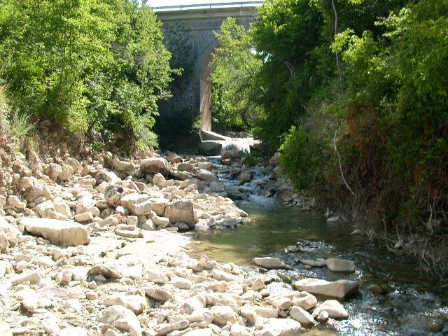
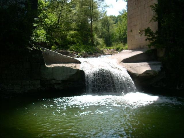
4 The Candelaro River It is served by the largest Italian Irrigation Consortium. Several EU and National research project carried out in the area. Includes some Vulnerable Zones ( EU Nitrates Directive). Member of the Pilot River Basins set up by the WFD-CIS. The Candelaro river basin is one of the three important regional river basin with a well defined surface hydrography. It is located in the second plain in Italiy in an important intensive agricultural area. The Candelaro river flows down to an important National nature reserve wetland area


5 Analysing flow regime at reach scale Gallart and Prat propose to analyse streamflow at reach scale. The method is based on the relative frequencies of the occurrence of specific flow conditions DRY CONNECTED POOLS RIFFLE DISCONNECTED POOLS FLOOD
 100% 80% 60% 40% 20% 0% O N D J F M A M J J A S frequency 100% 80% 60% 40% 20% Vulgano Ponte Troia (94 km 2 ) 0% O N D J F M A M J J A S 100% Seasonal regime Floods occur in winter and early")
6 frequency Frequency of Flow Status Triolo - Ponte Lucera (53.8 km 2 ) 100% 80% 60% 40% 20% 0% O N D J F M A M J J A S frequency Salsola - Casanova (43.1 km 2 ) 100% 80% 60% 40% 20% 0% O N D J F M A M J J A S frequency 100% 80% 60% 40% 20% Vulgano Ponte Troia (94 km 2 ) 0% O N D J F M A M J J A S 100% Seasonal regime Floods occur in winter and early spring Dry conditions occur from May to December frequency 80% 60% 40% 20% Celone S. Vincenzo (85.8 km 2 ) 0% O N D J F M A M J J A S month dry pools connected riffles flood
 Stream type Flow duration Pools duration Dry period Permanent 10")

7 Permanent, intermittent-pools, intermittent-dry or episodic? (MIRAGE Project suggestion) Stream type Flow duration Pools duration Dry period Permanent 10 months per year 2 months per year No occurrence Intermittent-pools 3 months per year 9 months per year 1 month Intermittent-dry 3 months per year 1 but < 3 1 month Ephemeral-Episodic < 2 months per year < 2 months 10 months

8 Types of temporary streams General Classification Number of River Segments River Length, Km Total Length % Episodic Intermittent Dry Intermittent Pools Permanent
9 MIRAGE protocol to evaluate HS (Hydrological Status) The method assumes that in temporary streams the interruption of flow is the main feature affecting the aquatic life. Instead of using the several available statistics about flow, we decided to look for two metrics which focus on flow interruption and not on amount of flow (Gallart et al., 2012).
10 MIRAGE protocol to evaluate HS Define surface water bodies (fragmentation into river reaches) Search information about river network and basin characteristics Determine whether or not upstream impacts are potentially significant No Yes MIRAGE Procedure Natural status (RC) Actual status (AC) Data availability Yes Data availability Yes No No Generate streamflow data (Derive data combining impacts with measured flow data Or use Hydrological models) Generate streamflow data (Derive data combining impacts with natural streamflow or use hydrological models able to simulate impacted conditions Calculate Mf and Sd6 Calculate Mf and Sd6 TRS Plot Classify flow regime in AC and RC Determine the distance between natural and actual metrics Determine changes in regime class Final classification Ecological response of flow alteration
11 A metric for efficient characterisation, ranking and comparison of stream regimes Several indexes tested (IHA). Redundancy checked using PCA and correlation coefficients. Only flow permanence (Mf) and the seasonal predictability of dry periods (Sd6) were selected for the subsequent analyses. Flow permanence (Mf) = number of months with flow (rescaled 0-1) Predictability (Sd6) = the more orthogonal of the metrics tested. Sd Fd i / Fd j 1 1 Fdi is the multiannual frequency of no-flow months for contiguous 6 wetter months per year Fdj is the multiannual frequency of no-flow months for the 6 dryer months
12 Observed streamflow vs the best simulation for un-impacted conditions (reach Salsola gauge 4) /1/90 2/1/90 3/1/90 4/1/90 5/1/90 6/1/90 7/1/90 8/1/90 9/1/90 10/1/90 11/1/90 12/1/90 Flow (m 3 /s) 95PPU observed Best_Sim 95% prediction uncertainty (95PPU) using SWAT-CUP
13 Model Performance for low flow conditions Gauge 4 Gauge 1 NSE R NSE R Calibration Validation It is well known that watershed models suffer from uncertainty in predictions from model structures, input data and parameters (Refsgaard et al., 2007). Uhlenbrook et al. (1999) pointed out that the effects of the model and parameter uncertainties were larger for low flow conditions than for the flood events.
14 Realistic simulation of no-flow conditions The simulation of low flow may be a weak point in the use of hydrological models. Extreme low flow conditions tend to be overestimated by most hydrological models (Kirkby et al., 2011). The no-flow condition is a key point in the metric calculations, thus, it is critically important to understand if the extreme low flow conditions predicted by the model are realistic or not. If predicted extreme low flow in the best simulation is not zero in those reaches which are recognized as temporary streams, a correction of calculated flow series is needed before calculating the metrics. We define Zero Flow threshold the simulated streamflow value that corresponds to actual dry conditions (no flow) in a reach. This value is specific for each river section depending on the local conditions such as geology, hydraulic conductivity and river bed permeability, transmission losses, and channel width.
15 Zero Flow Thresholds: corrections These zero flow values should be determined contemporaneously comparing simulated and measured streamflow data. An attempt has been made to define these thresholds. In correspondence with the driest summers recorded in the past (1990) during which the river network was dry all over the basin, for each river section we assumed the extreme low flow value simulated by the model in that period as Zero Flow threshold. The values resulted to be: m 3 s -1 (gauge 3); m 3 s -1 (gauge 4); m 3 s -1 (gauge 1); m 3 s -1 (gauge 2).
16 Mf-Sd6 plot for the actual streamflow data R11i R16 R7i R2i R4i R5i R10i R12i R6i Seasonal Predictability (Sd6) R8i R1i E I-D I-P P Flow occurrence (Mf)
17 Plot in actual conditions for the reaches R7 (a) and R1 (b) in different years Seasonal Predictability (Sd6) (a) Flow occurrence (Mf) (b)
18 Plot in natural conditions Seasonal Predictability (Sd6) R1 R16 E I-D I-P R4 R2 R6 R7 R8 R10 R12 R11 R5 P Natural conditions simulated using SWAT and removing WWTP inlet and irrigation withdrawals Flow occurrence (Mf)
 < Mf (natural) Possibly due to withdrawal or reservoirs. Changes of river type classification may happen.")
19 NATURAL vs ACTUAL (impacted) situation Mf (actual) > Mf (natural) The presence of point source discharges increases the permanence of flow. Water quality implications Mf (actual) < Mf (natural) Possibly due to withdrawal or reservoirs. Changes of river type classification may happen. Distance matters


.")
20 Hydrological alteration classification Final Hydrological alteration classification The last class groups the river segments which are severely impacted (R8) and heavy modified (R10, R11, R12).
21 Conclusions (1) Flows are naturally highly variable both in space and time in this catchment. Low flow and dry conditions have been altered in the main course of the Candelaro river in the floodplain due to WWTPs discharges, water abstractions, river modifications. The flow regime is natural only in the upper part of the tributaries where dry conditions are a natural features and is related to the geomorphology of the streams. Dry or disconnected pool statuses are frequent at the end of the summer period and their duration varies from one year to another and from reach to reach. Most of the streams are generally classified as Intermittent Dry and Intermittent Pools. The proposed Plot allows to highlight changes and to understand possible causes of flow modification. The proposed Plot allows to classify rivers based on flow characteristics.

, compares the metrics in actual state and natural state.")
22 Conclusions (2) The classification of the river reaches regimes based on the occurrence of the different mesohabitat has proved to be a valuable operational tool to helps biologists in selecting the sampling. For reaches classified as I-P and I-D samplings have to be adapted to the hydrological regime. The proposed approach to evaluate hydrological status is a fast way to identify river reaches in critical hydrological conditions. The method, which analyzes only the changes occurring in two factors (flow permanence and dry seasonal predictability), compares the metrics in actual state and natural state. If critical hydrological conditions take place, further analysis must be carried out. Even if the SWAT model has proved to be a valuable tool in simulating streamflow in natural status, extreme low flow can be a weak point in model simulations: it is important to understand if the extreme low flows simulated by the model are realistic. In this case we identified a Zero-Flow threshold value through data analysis, expert judgment and field observations which corresponds to no flow conditions. A correction of the flow series was done before calculating the metrics.

23 Thank you for your attention
MODELLING STREAMFLOW TO SET AN ENVIRONMENTAL FLOW. A.M. De Girolamo*, A. Lo Porto IRSA, CNR, Bari, Italy
 MODELLING STREAMFLOW TO SET AN ENVIRONMENTAL FLOW A.M. De Girolamo*, A. Lo Porto Annamaria.degirolamo@ba.irsa.cnr.it IRSA, CNR, Bari, Italy Introduction Streamflow is a critical determinant of ecological
Deliverable 9: The TREHS manual
 Deliverable 9: The TREHS manual June 2015 Contact: F.E.M. Research Group, Departament d'ecologia, Facultat de Biologia, UB Diagonal, 643-08028 Barcelona +34 93 403 11 88 lifetrivers@ub.edu www.lifetrivers.eu
HYDROLOGICAL ANALYSIS OF FLOW VARIATIONS ON SHPP SITE
 13 th International Symposium on Water Management and Hydraulic Engineering, September 9-12, 2013 Bratislava, Slovakia HYDROLOGICAL ANALYSIS OF FLOW VARIATIONS ON SHPP SITE Gordon Gilja 1, Eva Ocvirk 2
Functioning and values of streams
 Functioning and values of streams Flow regimes and ecological functioning Difference between perennial, intermittent and ephemeral streams The ecological relevancy of hydrological regimes Characterisation
Hydrological analysis of the Evrotas basin, Greece
 Alterra is part of the international expertise organisation Wageningen UR (University & Research centre). Our mission is To explore the potential of nature to improve the quality of life. Within Wageningen
Information for EFSAB:
 Information for EFSAB: Stream-ecology and flow relationships based on our ACF research Transferability of species preferences Defensibility of ACF work in context of controversy Mary Freeman USGS Patuxent
Establishing Environmental Flows for California Streams. Eric Stein Southern California Coastal Water Research Project
 Establishing Environmental Flows for California Streams Eric Stein Southern California Coastal Water Research Project What Do We Know About the Status of Flows Statewide? First comprehensive study recently
Relationships between low-flow characteristics of South African streams
 Relationships between low-flow characteristics of South African streams VY Smakhtin * and M Toulouse Institute for Water Research, Rhodes University, PO Box 94, Grahamstown, 64, South Africa Ecole Nationale
Hydrology Attribute 1/15/2016. California Rapid Assessment Method for Wetlands. Hydrology. Precipitation Increases the Extent of Wetlands
 California Rapid Assessment Method for Wetlands Hydrology Attribute Hydrology Determines existence of wetlands, drives primary physical and ecological processes: Establishment of reducing conditions Nutrient
WHERE WISDOM IS FREE. Dr. Ajai Singh Uttar Banga Krishi Viswavidyalaya West Bengal
 WHERE WISDOM IS FREE Dr. Ajai Singh Uttar Banga Krishi Viswavidyalaya West Bengal E-mail: ajai_jpo@yahoo.com Balanced ecosystems are essential for the survival and welfare of humankind. The ecosystems
Study of Hydrology based on Climate Changes Simulation Using SWAT Model At Jatiluhur Reservoir Catchment Area
 Study of Hydrology based on Climate Changes Simulation Using SWAT Model At Jatiluhur Reservoir Catchment Area Budi Darmawan Supatmanto 1, Sri Malahayati Yusuf 2, Florentinus Heru Widodo 1, Tri Handoko
Application of SWAT Model in land-use. change in the Nile River Basin: A Review
 Application of SWAT Model in land-use change in the Nile River Basin: A Review By: Marwa Ali, Okke Batelaan and Willy Bauwens 15-6-2011 Application of SWAT Model in land-use 1 change in the Nile River
Hydrological Modeling of the Black Sea Catchment using SWAT
 South Korea, August, 2010 Hydrological Modeling of the Black Sea Catchment using SWAT Elham Rouholahnejad elham.rouholahnejad@ eawag.ch Content: Part 1: Black Sea General Information Part 2: envirogrids
Modelling the impact of land use change on the water balance in the Xiangxi Catchment (Three Gorges Region, China) using SWAT
 using SWAT") Modelling the impact of land use change on the water balance in the Xiangxi Catchment (Three Gorges Region, China) using SWAT K. Bieger, B. Schmalz, Q. Cai, N. Fohrer 2010 International SWAT Conference
Modelling the impact of land use change on the water balance in the Xiangxi Catchment (Three Gorges Region, China) using SWAT K. Bieger, B. Schmalz, Q. Cai, N. Fohrer 2010 International SWAT Conference
GIS Applications in Water Resources Engineering
 King Fahd University of Petroleum & Minerals City & Regional Planning Department Introduction to Geographic Information Systems Term Paper Presentation GIS Applications in Water Resources Engineering Prepared
Hydrological And Water Quality Modeling For Alternative Scenarios In A Semi-arid Catchment
 Hydrological And Water Quality Modeling For Alternative Scenarios In A Semi-arid Catchment AZIZ ABOUABDILLAH, ANTONIO LO PORTO METIER Final Conference: Brussels, Belgium-4-6 November 2009 Outline Problem
EFFECTS OF WATERSHED TOPOGRAPHY, SOILS, LAND USE, AND CLIMATE ON BASEFLOW HYDROLOGY IN HUMID REGIONS: A REVIEW
 PROGRESS IN PHYSICAL GEOGRAPHY EFFECTS OF WATERSHED TOPOGRAPHY, SOILS, LAND USE, AND CLIMATE ON BASEFLOW HYDROLOGY IN HUMID REGIONS: A REVIEW KATIE PRICE 2011 Presented by: Jordan Martin Article Overview
CHAPTER FIVE Runoff. Engineering Hydrology (ECIV 4323) Instructors: Dr. Yunes Mogheir Dr. Ramadan Al Khatib. Overland flow interflow
 Instructors: Dr. Yunes Mogheir Dr. Ramadan Al Khatib. Overland flow interflow") Engineering Hydrology (ECIV 4323) CHAPTER FIVE Runoff Instructors: Dr. Yunes Mogheir Dr. Ramadan Al Khatib Overland flow interflow Base flow Saturated overland flow ١ ٢ 5.1 Introduction To Runoff Runoff
Engineering Hydrology (ECIV 4323) CHAPTER FIVE Runoff Instructors: Dr. Yunes Mogheir Dr. Ramadan Al Khatib Overland flow interflow Base flow Saturated overland flow ١ ٢ 5.1 Introduction To Runoff Runoff
Application the SWAT model for Extreme Urban Flash Floods in Seoul
 Application the SWAT model for Extreme Urban Flash Floods in Seoul 18 July 2013 International SWAT Conference, Toulouse, France Hyung Kyung Joh / Researcher / Weather Information Service Engine Division
Reservoir on the Rio Boba
 Reservoir on the Rio Boba Michael J. Burns II Guillermo Bustamante J. James Peterson Executive Summary The National Institute of Water Resources in the Dominican Republic (INDRHI) plans to construct a
Impact of Future Climate Change on the Water Resources System of Chungju Multi-purpose Dam in South Korea
 2012 International SWAT Conference Impact of Future Climate Change on the Water Resources System of Chungju Multi-purpose Dam in South Korea 19 July 2012 PARK, Jong-Yoon* / JUNG, In-Kyun / Jang, Cheol-Hee
Estimation of Actual Evapotranspiration at Regional Annual scale using SWAT
 Estimation of Actual Evapotranspiration at Regional Annual scale using SWAT Azizallah Izady Ph.D student of Water Resources Engineering Department of Water Engineering, Faculty of Agriculture, Ferdowsi
Manifesto from the Workshop Climate Change Impacts on Groundwater
 Manifesto from the Workshop Climate Change Impacts on Groundwater EU Working Group C workshop October 12th, Warsaw A workshop on Climate Change Impacts on Groundwater was held in Warsaw under the umbrella
River Processes River action (fluvial)
") River action (fluvial) is probably the single most important geomorphic agent and their influence in geomorphology can hardly be overestimated. 1 To understand the complexity associated with river flow
River action (fluvial) is probably the single most important geomorphic agent and their influence in geomorphology can hardly be overestimated. 1 To understand the complexity associated with river flow
PUBLIC REVIEW SESSION
 Carolina North Ecological Assessment PUBLIC REVIEW SESSION Carolina North Ecological Assessment Carolina North Ecological Assessment Carolina North Ecological Assessment http//cn.unc.edu Background Ecological
Assessment of nitrogen retention in the Seine river basin by different approaches
 Assessment of nitrogen in the Seine river basin by different approaches Grizzetti B. 1, Passy P. 1, Billen G. 1, Garnier J. 1, Bouraoui F. 2 1 CNRS/University Pierre et Marie Curie, Paris, France 2 European
Carolina North Ecological Assessment. Carolina North Ecological Assessment PEER REVIEW
 Carolina North Ecological Assessment PEER REVIEW Carolina North Ecological Assessment Background Ecological Characterization and land development suitability analysis for the Carolina North property Goal
The DNR is charged with managing waters resources to assure an adequate and sustainable supply for multiple uses.
 The DNR is charged with managing waters resources to assure an adequate and sustainable supply for multiple uses. Minnesota Laws 2015, chapter 4, article 4, directed the Department of Natural Resources
Existing Land Use USACE Fountain Creek Watershed Study Watershed Management Plan, Pueblo
 Existing Land Use USACE Fountain Creek Watershed Study Watershed Management Plan, 2009 Pueblo N Future Land Use (2025) USACE Fountain Creek Watershed Study Watershed Management Plan, 2009 Pueblo N Project
Aqueduct 2.0 Project Water Indicators
 Aqueduct 2.0 Project Water Indicators The Aqueduct 2.0 is a project of the World Resources Institute, which was the source of the indicators presented here (Gassert et al., 2013). Sustainability Goals:
Stream Hydrology. Watershed 8/29/13. Area that contributes water to a point on a stream Scale is user-defined Other names: Catchment Drainage basin
 Stream Hydrology Watershed Area that contributes water to a point on a stream Scale is user-defined Other names: Catchment Drainage basin http://warnercnr.colostate.edu/geo/front_range/poudre.php# 1 Basics
Virtual Water Accounting: A New Framework for Managing Great Lakes Water Resources
 Virtual Water Accounting: A New Framework for Managing Great Lakes Water Resources Alex Mayer, Michigan Technological University Ben Ruddell, Arizona State University Stanley Mubako, University of Texas,
Climate Change Vulnerability in the Black Sea Catchment. Roger Bär and Anthony Lehmann
 Climate Change Vulnerability in the Black Sea Catchment Roger Bär and Anthony Lehmann The EU envirogrids project: April 2009- March 2013 1. Introduction Black Sea catchment (2.2mio Km 2, >150mio inhabitants)
Adaptive Policy Responses to Climate Change Scenarios in the Musi Catchment, India
 Proceedings of the 2 nd World Congress on Civil, Structural, and Environmental Engineering (CSEE 17) Barcelona, Spain April 2 4, 2017 Paper No. AWSPT 155 ISSN: 2371-5294 DOI: 10.11159/awspt17.155 Adaptive
Climate change: Impact on nitrogen export from different land-use types in a reservoir catchment
 Faculty of Environmental Sciences, Department of Forest Sciences, Institute of Soil Science and Site Ecology Climate change: Impact on nitrogen export from different land-use types in a reservoir catchment
GIS Framework to Evaluate Impact of Climate Change on Water Resources
 GIS Framework to Evaluate Impact of Climate Change on Water Resources Dr. Nagraj S. Patil A. K. Gosain, Professor Civil Engineering Department I. I. T. Delhi Objectives of the Study To Develop portal to
MANAGING FRESHWATER INFLOWS TO ESTUARIES
 MANAGING FRESHWATER INFLOWS TO ESTUARIES The preparation of this document was made possible through support provided by the Office of Natural Resources Management, Bureau for Economic Growth, Agriculture
Assessment of Ecosystem services with considering impact of Climate change on Godavari basin. Indian Institute of Technology Hyderabad, India
 Assessment of Ecosystem services with considering impact of Climate change on Godavari basin Amarnath C R Research Scholar Dr. Shashidhar Associate Professor Indian Institute of Technology Hyderabad, India
CE 2031 WATER RESOURCES ENGINEERING L T P C
 CE 2031 WATER RESOURCES ENGINEERING L T P C 3 0 0 3 QUESTION BANK PART - A UNIT I GENERAL 1. Write short notes on Water Resources Survey. 2. How do you calculate Average Annual Runoff depth? 3. Write short
Chapter 1 Introduction
 Engineering Hydrology Chapter 1 Introduction 2016-2017 Hydrologic Cycle Hydrologic Cycle Processes Processes Precipitation Atmospheric water Evaporation Infiltration Surface Runoff Land Surface Soil water
Integrated Modeling of the Food, Energy, and Water System
 Integrated Modeling of the Food, Energy, and Water System Andrew J. Plantinga Bren School of Environmental Science and Management University of California, Santa Barbara Overview of My Talk Present a conceptual
Anthropogenic and climate change contributions to uncertainties in hydrological modeling of sustainable water supply
 Anthropogenic and climate change contributions to uncertainties in hydrological modeling of sustainable water supply Roman Corobov The Republic of Moldova Several words about Moldova The Republic of Moldova
Working together To improve our water environment Glazert Water
 Working together To improve our water environment Glazert Water Potential options for river restoration and natural flood management in the Glazert catchment Draft summary report 1.0 Introduction 1 Report
Minnesota River Integrated Watershed Management Interagency Study Team Meeting Of the Modeling Focus Group
 Minnesota River Integrated Watershed Management Interagency Study Team Meeting Of the Modeling Focus Group 28 September, 2010 University of Minnesota St. Paul, MN EXECUTIVE SUMMARY 1 SECTION I EXECUTIVE
Standardized Runoff Index (SRI) Evaluation
 Evaluation") Standardized Runoff Index (SRI) Evaluation Adolfo Mérida Abril Cecilia Muñoz Lobo Contents 1. Background 2. Final SRI factsheet 3. Main goals 4. Description of the participants 5. Evaluation phases 6.
Standardized Runoff Index (SRI) Evaluation Adolfo Mérida Abril Cecilia Muñoz Lobo Contents 1. Background 2. Final SRI factsheet 3. Main goals 4. Description of the participants 5. Evaluation phases 6.
Climate change and water resources management - French feedbacks
 Climate change and water resources management - French feedbacks Context o Paris pact on water and adaptation to climate change in the basins of rivers, lakes and aquifers signed by 358 basins organizations
Bonsall Creek Watershed Management Plan Gap Analysis
 Bonsall Creek Watershed Management Plan Gap Analysis March 2015 Prepared by Gap Analysis Introduction The Bonsall Creek Watershed Management Plan provides a vision for water use in the watershed, including
Thematic Presentation. Climate Change Impacts on Water cycle and. Ecosystems
 Thematic Presentation Climate Change Impacts on Water cycle and Ecosystems Overview Climatic change will strongly impacts surface and groundwater Quantity Seasonality Quality (aquatic ecosystems and potential
From the cornbeltto the north woods; understanding the response of Minnesota. Chris Lenhart Research Assistant Professor BBE Department
 From the cornbeltto the north woods; understanding the response of Minnesota watersheds to climate change Chris Lenhart Research Assistant Professor BBE Department 1. Background Differential response of
Indicators of Hydrologic Stress in Massachusetts
 Indicators of Hydrologic Stress in Massachusetts Sara Brandt 1, Richard M. Vogel 2 and Stacey Archfield 3 1 Department of Civil and Environmental Engineering, Tufts University, Medford, MA, email: sara.brandt@tufts.edu,
Refined Application of the SWAT Model for Endangered Species Effects Determination
 Refined Application of the SWAT Model for Endangered Species Effects Determination Michael Winchell 1, Solomon Folle 2, Roger Breton 3 1. Stone Environmental Inc., Montpelier, Vermont 2. University of
Modeling watershed nutrient fluxes & delivery to coastal waters. Pennsylvania State University. Collaborators
 Modeling watershed nutrient fluxes & delivery to coastal waters Elizabeth W. Boyer Pennsylvania State University Collaborators Richard Alexander Gregory Schwarz Richard Smith US Geological Survey National
SEES 503 SUSTAINABLE WATER RESOURCES. Floods. Instructor. Assist. Prof. Dr. Bertuğ Akıntuğ
 SEES 503 SUSTAINABLE WATER RESOURCES Floods Instructor Assist. Prof. Dr. Bertuğ Akıntuğ Civil Engineering Program Middle East Technical University Northern Cyprus Campus SEES 503 Sustainable Water Resources
Water Resources Status in Danube River Basin. SWAT Conference_ Spain, Toledo June 2011
 Water Resources Status in Danube River Basin SWAT Conference_ Spain, Toledo June 2011 Objectives Objectives Building and calibratîng a hydrologic model of Danube Basin Using SWAT and SWAT CUP Quantifying
Climate change impact assessement considering water discharge and nutrients in a mesoscale coastal watershed
 Climate change impact assessement considering water discharge and nutrients in a mesoscale coastal watershed - input from a catchment to its lagoon- Anastassi Stefanova 1 *, Cornelia Hesse 1, Valentina
Joint Research Centre (JRC)
") Joint Research Centre (JRC) Marco Pastori and Faycal Bouraoui IES - Institute for Environment and Sustainability Ispra - Italy http://ies.jrc.ec.europa.eu/ http://www.jrc.ec.europa.eu/ CONTENT Introduction
Joint Research Centre (JRC) Marco Pastori and Faycal Bouraoui IES - Institute for Environment and Sustainability Ispra - Italy http://ies.jrc.ec.europa.eu/ http://www.jrc.ec.europa.eu/ CONTENT Introduction
The Fourth Assessment of the Intergovernmental
 Hydrologic Characterization of the Koshi Basin and the Impact of Climate Change Luna Bharati, Pabitra Gurung and Priyantha Jayakody Luna Bharati Pabitra Gurung Priyantha Jayakody Abstract: Assessment of
Hydrologic Regime; Past and Present and Water Quality Implications
 Hydrologic Regime; Past and Present and Water Quality Implications Waseca County Water Plan Meeting Waseca County Courthouse Annex November 16, 2016 Dan Girolamo, Area Hydrologist, Waterville, MN Topics
Retrospective analysis of hydrologic impacts in the Chesapeake Bay watershed
 Retrospective analysis of hydrologic impacts in the Chesapeake Bay watershed Harsh Beria1,3, Rob Burgholzer2, Venkat Sridhar3 Indian Institute of Technology Kharagpur, India & Summer intern Virginia Department
ICELANDIC RIVER / WASHOW BAY CREEK INTEGRATED WATERSHED MANAGEMENT PLAN STATE OF THE WATERSHED REPORT CONTRIBUTION SURFACE WATER HYDROLOGY REPORT
 ICELANDIC RIVER / WASHOW BAY CREEK INTEGRATED WATERSHED MANAGEMENT PLAN STATE OF THE WATERSHED REPORT CONTRIBUTION SURFACE WATER HYDROLOGY REPORT Disclaimer: The hydrologic conditions presented in this
OFFICE OF STRUCTURES MANUAL ON HYDROLOGIC AND HYDRAULIC DESIGN CHAPTER 3 POLICY AND PROCEDURES
 OFFICE OF STRUCTURES MANUAL ON HYDROLOGIC AND HYDRAULIC DESIGN CHAPTER 3 POLICY AND PROCEDURES April 28, 2016 Table of Contents 3.1 Introduction... 2 3.1.1 Purpose of Chapter 3... 2 3.1.2 Policy vs. Design
Term Project. NFIE-River: Cross section approximations for hydraulic channel routing model in the San Antonio and Guadalupe River Basins.
 Flood Forecasting Spring - 2015 Due Friday 05/08/2015 Alfredo Hijar Term Project NFIE-River: Cross section approximations for hydraulic channel routing model in the San Antonio and Guadalupe River Basins.
CENTRAL ASSINIBOINE INTEGRATED WATERSHED MANAGEMENT PLAN SURFACE WATER HYDROLOGY REPORT
 CENTRAL ASSINIBOINE INTEGRATED WATERSHED MANAGEMENT PLAN SURFACE WATER HYDROLOGY REPORT Planning Area Boundary: The Central Assiniboine planning area covers the reach of the Assiniboine River from just
Riscuri şi Catastrofe
 RISCURI ŞI CATASTROFE, NR. X, VOL. 9, NR. 2/2011 BARCĂU RIVER HYDROLOGICAL CHARACTERIZATION DURING THE 1993-2009 PERIOD N. JOSAN 1, D. DUME 2, SIMONA GABRIELA ANDRIŞCA 2 ABSTRACT. Barcau River Hydrological
DEVELOPMENT OF AQUIFER TESTING PLANS. Brent Bauman, P.G. / Erin Lynam, Aquatic Biologist
 DEVELOPMENT OF AQUIFER TESTING PLANS Brent Bauman, P.G. / Erin Lynam, Aquatic Biologist DEVELOPMENT OF AQUIFER TESTING PLANS Goals of Aquifer Testing What questions are we trying to answer Staff review
Drought management and early warning in the Po River Basin
 Drought management and early warning in the Po River Basin Claudia Vezzani Po river basin Authority Po Basin features The Po River is the major Italian river. The basin lies between the continental and
Review of Hydrological Potential in Combined Gin and Nilwala River Basins of Sri Lanka
 Review of Hydrological Potential in Combined Gin and Nilwala River Basins of Sri Lanka A.V.D.Fernando 1, L.S.Sooriyabandara 2 and G.H.A.C.Silva 1 1 Department of Civil and Environmental Engineering, Faculty
Current and future projections of glacier contribution to streamflow in the upper Athabasca River Basin
 Current and future projections of glacier contribution to streamflow in the upper Athabasca River Basin Canadian Geophysical Union: May 2017 H06: Advances in Cold Regions Hydrology M. Chernos 1,2, R.J.
Table ES1. Review of Pebble Limited Partnership s (PLP s) Environmental Baseline Document (EBD): Hydrologic characterization
 Environmental Baseline Document (EBD): Hydrologic characterization") Executive Summary Table ES1. Review of Pebble Limited Partnership s (PLP s) Environmental Baseline Document (EBD): Hydrologic characterization Basic issue Does PLP have sufficient hydrologic data and an
Executive Summary Table ES1. Review of Pebble Limited Partnership s (PLP s) Environmental Baseline Document (EBD): Hydrologic characterization Basic issue Does PLP have sufficient hydrologic data and an
Define possible adaptive options based on the assessment of territorial and social vulnerability
 Climate change impacts on water availability in three Mediterranean watersheds of Catalonia (NE Spain) Diana Pascual, Eduard Pla (CREAF) Roger Milego (ETC-SIA) SCARCE 2nd annual conference INDEX 1.The
Ecological Flow Assessments in Eastern U.S. Basins Tara Moberg. December 10, 2014 NAS Roundtable on Science and Technology for Sustainability
 Ecological Flow Assessments in Eastern U.S. Basins Tara Moberg December 10, 2014 NAS Roundtable on Science and Technology for Sustainability What are Ecological Flows? The flow of water in a natural river
CHAPTER 3 Environmental Guidelines for WATERCOURSE CROSSINGS GOVERNMENT OF NEWFOUNDLAND AND LABRADOR DEPARTMENT OF ENVIRONMENT AND LABOUR
 GOVERNMENT OF NEWFOUNDLAND AND LABRADOR DEPARTMENT OF ENVIRONMENT AND LABOUR CHAPTER 3 Environmental Guidelines for WATERCOURSE CROSSINGS WATER RESOURCES MANAGEMENT DIVISION Water Investigations Section
SOUTHEAST TEXAS CONTINUING EDUCATION
 EXAM No. 118 FLOOD - RUNOFF ANALYSIS 1. Information gained from flood - runoff analysis includes which one: A. Stage, discharge, volume. B. Measure depth, volume. C. Velocity, depth, storm occurrence.
Resolving uncertainties in the source of low flows in South African rivers using conceptual and modelling studies
 Conceptual and Modelling Studies of Integrated Groundwater, Surface Water, and Ecological Systems 127 (Proceedings of Symposium H1 held during IUGG211 in Melbourne, Australia, July 211) (IAHS Publ. 345,
Climate Impacts and Water Sources in the Riparian Zone James Hogan
 Climate Impacts and Water Sources in the Riparian Zone James Hogan NSF STC for Sustainability of Semi-Arid Hydrology and Riparian Areas (SAHRA) Department of Hydrology and Water Resources College of Engineering
Upstream structural management measures for an urban area flooding in Turkey
 doi:10.5194/piahs-370-45-2015 Author(s) 2015. CC Attribution 3.0 License. Upstream structural management measures for an urban area flooding in Turkey Z. Akyurek 1, B. Bozoğlu 1, S. Sürer 2, and H. Mumcu
Gomez-Balandra., M.A*., P. Saldaña F*., R. Llerandi J**., C. Lecanda T**., M. Mijangos C*., and S. Rodriguez T*.
 Indicators to follow-up hydro impacts and mitigation Gomez-Balandra., M.A*., P. Saldaña F*., R. Llerandi J**., C. Lecanda T**., M. Mijangos C*., and S. Rodriguez T*. *Mexican Institute of Water Technology
Information Requirements Table for Liquid Waste
 Applicant Summary Tracking # Authorization # Applicant / Facility Name Ministry of Environment Prepared by: Title Date The Information Requirements Table (IRT) for Liquid Waste is a tool used by Ministry
An Introduction to Environmental Flows
 An Introduction to Environmental Flows The natural flow regime Flow alteration Environmental flows defined Scaling up Eloise Kendy, Ph.D. IUCN workshop Kathmandu, Nepal 5 August 2011 Jefferson River, Montana
Ina Pohle 1,2, Anne Gädeke 3, Hagen Koch 4, Sabine Schümberg 1, Christoph Hinz 1 1) 2) 3) 4)
 2) 3) 4)") The effect of water resources management on uncertainties inherent in climate change impact studies - case study of the Lusatian river basins (Central Europe) Ina Pohle 1,2, Anne Gädeke 3, Hagen Koch 4,
The effect of water resources management on uncertainties inherent in climate change impact studies - case study of the Lusatian river basins (Central Europe) Ina Pohle 1,2, Anne Gädeke 3, Hagen Koch 4,
Ongoing and Completed Studies
 Attachment 2 Ongoing and Completed Studies 2014 Monitoring and Analysis Plan November 2013 Attachment 2 Ongoing and Completed Studies 1 Introduction In 2013, the small interdisciplinary study groups for
A comparative study of the methods for estimating streamflow at ungauged sites
 22nd International Congress on Modelling and Simulation, Hobart, Tasmania, Australia, 3 to 8 December 2017 mssanz.org.au/modsim2017 A comparative study of the methods for estimating streamflow at ungauged
Regional Aquifer Recharge to Support San Pedro River Baseflows, Flood Flows and Groundwater
 Regional Aquifer Recharge to Support San Pedro River Baseflows, Flood Flows and Groundwater Brooke Bushman & Holly Richter, AZ Water Projects November 7, 2017 San Pedro River Tributary of the Colorado
Module 3. Lecture 6: Synthetic unit hydrograph
 Lecture 6: Synthetic unit hydrograph Synthetic Unit Hydrograph In India, only a small number of streams are gauged (i.e., stream flows due to single and multiple storms, are measured) There are many drainage
Appendix C. Demonstration Model
 Appendix C Demonstration Model Connecticut River Partnership Demonstration hydrologic/dam operations models Overview The Nature Conservancy, together with partners, has identified an altered flow regime
1 THE USGS MODULAR MODELING SYSTEM MODEL OF THE UPPER COSUMNES RIVER
 1 THE USGS MODULAR MODELING SYSTEM MODEL OF THE UPPER COSUMNES RIVER 1.1 Introduction The Hydrologic Model of the Upper Cosumnes River Basin (HMCRB) under the USGS Modular Modeling System (MMS) uses a
Low flow estimation in Austria
 Climate Variability and Change Hydrological Impacts (Proceedings of the Fifth FRIEND World Conference held at Havana, Cuba, November 2006), IAHS Publ. 308, 2006. 117 Low flow estimation in Austria GREGOR
Assessing climate impacts on hydropower production of Toce alpine basin
 Assessing climate impacts on hydropower production of Toce alpine basin Giovanni Ravazzani, Francesco Dalla Valle 2, Thomas Mendlik 3, Giorgio Galeati 2, Andreas Gobiet 3, Marco Mancini Politecnico di
Use of Conceptual Ecosystem Model to Structure Environmental Flow Assessment
 Use of Conceptual Ecosystem Model to Structure Environmental Flow Assessment Dr. Andrea Bradford & Andy Beaton Latornell Conservation Symposium November 20 th 2014 Nottawasaga, Ontario Outline What are
Europe - IMBO th European Conference on the Implementation of the WFD
 Europe - IMBO 2006 4th European Conference on the Implementation of the WFD Megeve 21 September 2006 The consideration of Qualitative and Quantitative aspects in the WFD Implementation Giorgio Pineschi
Brannen Lake Storage Feasibility Potential Effects on Water Levels
 Brannen Lake Storage Feasibility Potential Effects on Water Levels Brannen Lake Storage Feasibility Potential Effects on Water Levels Prepared for: BC Conservation Foundation #3, 1200 Princess Royal Avenue
Toward an Improvement of the Hydrological Performance of the SWAT Model under Snow Cover and during Snowmelt
 Toward an Improvement of the Hydrological Performance of the SWAT Model under Snow Cover and during Snowmelt Étienne Lévesque, Nicolas Beauchamp geau, Université Laval, Québec, Canada Ann van Griensven
Monitoring of water levels and flood discharge
 Monitoring of water levels and flood discharge Changes Workshop TS-02 & 11 th edition International Summer School Environmental Hazards & Sustainable Development in Mountain Regions Thom Bogaard Delft
Hydrological Modelling of Narmada basin in Central India using Soil and Water Assessment Tool (SWAT)
") Hydrological Modelling of Narmada basin in Central India using Soil and Water Assessment Tool (SWAT) T. Thomas, N. C. Ghosh, K. P. Sudheer National Institute of Hydrology, Roorkee (A Govt. of India Society
Hydrological Modelling of Narmada basin in Central India using Soil and Water Assessment Tool (SWAT) T. Thomas, N. C. Ghosh, K. P. Sudheer National Institute of Hydrology, Roorkee (A Govt. of India Society
Science Supporting Policy: The Case For Flow Quantity
 MassDEP Water Management Program Science Supporting Policy: The Case For Flow Quantity Integrating Water Resources Management UMASS Conference April 8, 2008 Overview Human impact on streamflow and aquatic
REQUEST FOR PROPOSALS University of Wyoming Office of Water Programs Water Research Program FY2018
 REQUEST FOR PROPOSALS University of Wyoming Office of Water Programs Water Research Program FY2018 The Office of Water Programs/Water Research Program welcomes proposals covering a wide range of topics
Assessment of the applicability of the SWAT model to simulate the streamflow in a rural catchment in the Federal District (Brazil)
") University of Brasilia - Brazil Department of Civil and Environmental Engineering Postgraduate Programme in Environmental Technology and Water Resources 2014 International SWAT Conference Porto de Galinhas
University of Brasilia - Brazil Department of Civil and Environmental Engineering Postgraduate Programme in Environmental Technology and Water Resources 2014 International SWAT Conference Porto de Galinhas
Modeling lixiviated nitrate by coupling agro-hydrological (SWAT) & hydrogeological (MARTHE) models
 & hydrogeological (MARTHE) models") 1 Modeling lixiviated nitrate by coupling agro-hydrological (SWAT) & hydrogeological (MARTHE) models Leccia O.*, Chatelier M.**, Vernier F.*, Bichot F. ** * IRSTEA, ETBX Bordeaux, 50 Av. de Verdun 33612
1 Modeling lixiviated nitrate by coupling agro-hydrological (SWAT) & hydrogeological (MARTHE) models Leccia O.*, Chatelier M.**, Vernier F.*, Bichot F. ** * IRSTEA, ETBX Bordeaux, 50 Av. de Verdun 33612
Flood hazard assessment in the Raval District of Barcelona using a 1D/2D coupled model
 9 th International Conference on Urban Drainage Modelling Belgrade 2012 Flood hazard assessment in the Raval District of Barcelona using a 1D/2D coupled model Beniamino Russo, David Suñer, Marc Velasco,
Turbidity Monitoring Under Ice Cover in NYC DEP
 Turbidity Monitoring Under Ice Cover in NYC DEP Reducing equifinality by using spatial wetness information and reducing complexity in the SWAT-Hillslope model Linh Hoang 1,2, Elliot M. Schneiderman 2,