Using GIS to Support Multi-year Pavement MR&R Need Analysis
|
|
|
- Todd Cummings
- 6 years ago
- Views:
Transcription
1 Using GIS to Support Multi-year Pavement MR&R Need Analysis Yichang(James) Tsai, Ph.D., P.E. Bo Gao, Ph.D. Candidate Georgia Institute of Technology Bryant Poole, P.E. JT Rabun, P.E. Georgia Department of Transportation March 30, 2004
2 Outline Background Project objective Why GIS System component and information flow Analytical Functionality Conclusions & Future Research Demo
 Survey data used to determine suitable treatment strategies.")
3 Background 18, 000 mile centerline highway. 7 working districts/13 cong. districts. Surveyed annually with about 60 engineers. 10 different types of distresses surveyed (i.g. load cracking) Project rating is between 0 and 100. Approximately 18,000 mile-segments in 2,000 projects surveyed annually. More than 18 years of survey data ( ) Survey data used to determine suitable treatment strategies. Total miles of projects treated are subject to budget availability.
4 Pavement Management Components Data Acquisition Data Management Decision Support Knowledge Discovery

5 Georgia Pavement Management (GPAM) Decision Support & Knowledge Discovery Multi-year Need Analysis
6 Project Objective Conduct what-if analysis as to when, where, what to treat, and their impacts on future pavement performance and cost in project and network levels. Integration between Need Analysis Modeling with GIS. Data integration with other data sources such AADT, etc.. Easy to use/communicate through GIS user interface. Validate and calibrate forecasted results such as project ratings, costs, etc.
7 GIS for Data Integration and Analysis Bridge Planning Design Construction Operation Performance measure Maintenance/Rehab Re-construction Other Data INTEGRATION AADT; % truck; Accidents, etc. Click a route on the GIS map to visualize all the associated information. Highway Pavement Planning Design Construction Operation Performance measure Maintenance/Rehab Re-construction INTEGRATION Common Location Reference System (LRS)
8 System Components PROJECT LEVEL ANALYSIS MODULE Treatment Method and Cost Determination. Pavement Performance Forecasting. Life Cycle Cost Effectiveness Analysis. NETWORK LEVEL ANALYSIS MODULE Determine minimal funding needed to meet prescribed future pavement performance. Determine optimum pavement treatment plans under funding availability constraints. Determine optimum pavement treatment plans subject to both pavement performance and budget availability constraints.
9 System Components (cont.) GIS MODULE Link GIS with various data sources such as traffic, bridges etc. Display analytical results on the map including the projects to be treated at different years with treatment methods and costs. Interactively change project treatment method on the map to see its impact on performance and cost in the project and network levels. Display the performance on the GIS map based on different jurisdictions such as GDOT District, Congressional District, county, etc.
10 Central Oracle Database Historical Pavement Condition Data Historical Maintenance Activity Data MR&R Methods and Costs Data Historical Traffic Data Network Analysis Results Summarize network level results GIS Visualization / Adjustment Output Results Final selection of individual projects with MR&R method and cost Feedback i = i+1 Network Level Analysis Y N Download latest pavement projects survey data Set inputs: 1. Network analysis problem type 2. Budget Constraints and/or Performance Constraints 3. Analysis period: n years 4. Select pavement performance model 5. Select pavement distresses forecasting model Satisfy balance constraints and/or performance and cost requirements? Start multi year analysis, set i=0 N i <= n Y Project Level Analysis Determine future project rating and distress deduct values Determine MR&R Methods and Costs for all projects Detailed System Information Flow End Calculate network composite rating Select a project, starting from highest cost effectiveness ratio Based on treatment methods, determine all projects performance after treatment Determine all projects life cycle cost effectiveness ratios


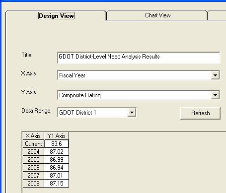
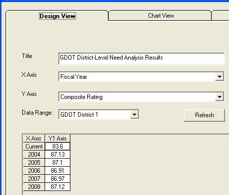
11 Example of Multi-year Pavement Need Analysis - Performances and Costs Network-level

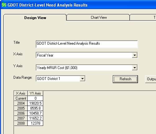
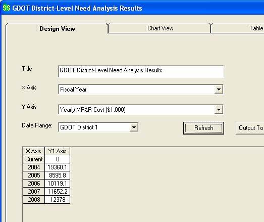
12 Example of Forecasted No. of Projects to be Treated and Cost Network-level

13 Network-level Pavement Condition

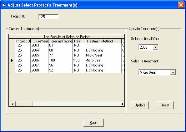
14 Selected Project, Treatment, and Cost a 1.b


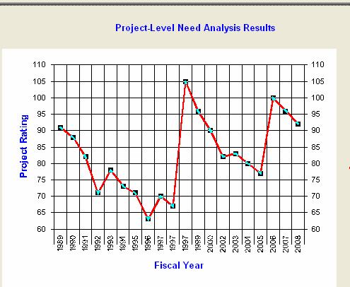
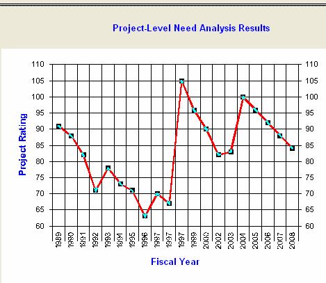
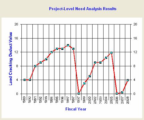
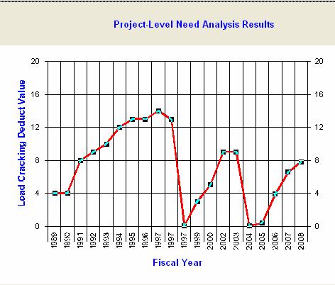
15 154 Historical Pavement Performance Analysis Fulton Dekalb Project-level

16 Impact Impact Impact on Network-Level on on Project-Level Network-Level Composite Load - Rating Cost Cracking Rating Dynamic Analysis Using GIS
17 Conclusions Link network-level performance/cost with project level plans. Perform what-if analysis in the network-level based on different treatment scenarios and balancing constraints. Dynamically change the project-level treatment method on the map to see its impact on project and network levels. Display project-level and network-level results on a GIS map.
18 Future Research Validate and calibrate models using historical data including rating, treatment method, and cost. Incorporate and test other performance models. Incorporate optimization solution.
19 Contact Info James Tsai, Ph.D., P.E. TEL:(404)
20 Thanks!
A GPS Enabled Handheld-based Pavement Coring and Condition Evaluation System
 Successful Implementation of A GPS Enabled Handheld-based Pavement Coring and Condition Evaluation System Zhaohua Wang, PhD James Tsai, PhD, PE Georgia Institute of Technology Steve Pahno Georgia Department
An Integrated GPS-based Mobile Data Collection and Web-based GIS Platform for Supporting GDOT s Pavement Rehabilitation and Design Processes
 An Integrated GPS-based Mobile Data Collection and Web-based GIS Platform for Supporting GDOT s Pavement Rehabilitation and Design Processes Zhaohua Wang Georgia Institute of Technology Steve Pahno, Teague
Georgia DOT Micro-milling and Thin Overlay
 Georgia DOT Micro-milling and Thin Overlay Presented by Yichang (James) Tsai, Ph.D., P.E., Professor Georgia Institute of Technology Erany Robinson-Perry, P.E., Assistant State Maintenance Engineer Georgia
Regional Transportation Studies Regional Council
 Pima Association of Governments 1 E. Broadway, Tucson, Arizona Santa Rita Conference Room Regional Transportation Studies Regional Council September 28, 2017 I-11 Tier 1 Environmental Impact Statement
Ian Kidner, GISP GIS Systems Administrator Office of Technical Services
 / Ian Kidner, GISP GIS Systems Administrator Office of Technical Services Ian.kidner@dot.ohio.gov 614-752-5743 TIMS Vision Provide Easy & Reliable Access to Information Data Consistency Enables Decision
Pavement Management Systems PMS PAVEMENT MANAGEMENT SYSTEMS OVERVIEW. Dr. Nick Vitillo
 Pavement Management Systems PMS PAVEMENT MANAGEMENT SYSTEMS OVERVIEW Dr. Nick Vitillo PMS CONCEPTS DISCUSSION TOPICS DEFINITION OF PM AND PMS PMS SUBSYSTEMS NETWORK & PROJECT LEVEL PMS PAVEMENT EVALUATION
PAMS: Leveraging a GIS-Based Pavement Assessment and Management System to Validate and Justify Roadway Project Formulation
 PAMS: Leveraging a GIS-Based Pavement Assessment and Management System to Validate and Justify Roadway Project Formulation AASHTO GIS for Transportation Symposium May 7, 2014 Candice Ottley-Francois, PMP,
Using Random Samples to Assess Roadway Condition. Faith Johnson GIS Specialist, NCDOT
 Using Random Samples to Assess Roadway Condition Faith Johnson GIS Specialist, NCDOT North Carolina Highway System 79,600 miles of state maintained roads Interstate: 1,326 Primary: 13,736 Secondary: 64,522
NYSDOT Roadway Inventory. Both On and Off the State System
 NYSDOT Roadway Inventory Both On and Off the State System 1 2 NYSDOT Highway Data Services Bureau Highway Data Traffic Monitoring Pavement Data Inventory of public roads, incl. LHI Systems designations
Building West Virginia DOT s Geospatial Capabilities:
 Building West Virginia DOT s Geospatial Capabilities: GIS Web Portal And Straight-line Diagram Application Current Status, Upcoming Enhancements, and Integration Marshall Burgess, WVDOT Don Kiel, GeoDecisions
Quantifying the Benefits of Pavement Management
 Quantifying the Benefits of Pavement Management Smadi, O Research Scientist Iowa State University Ames, Iowa, USA SYNOPSIS Pavement management systems (PMS) have been in operation since the early 1970s
Scoping & Design Project Level. By Robert J. Blight Principal Engineer Pavement Management & Technology
 Scoping & Design Project Level Data Collection & Analysis By Robert J. Blight Principal Engineer Pavement Management & Technology Goals Share process Provide knowledge Identify key data Feedback Reliable
Computer-Aided Maintenance Management
 52 TRANSPORTATION RESEARCH RECORD 1276 Computer-Aided Maintenance Management JOHN P. ZANIEWSKI AND MICHAEL J. WILES A maintenance management system (MMS) allows managers to organize and control maintenance
SELECTIVE FLEXIBLE PAVEMENT REHABILITATION BASED ON FORENSIC INVESTIGATION AND DEFLECTION ANALYSIS: SEVENTEEN YEARS CASE STUDY IN VIRGINIA
 0 0 0 0 SELECTIVE FLEXIBLE PAVEMENT REHABILITATION BASED ON FORENSIC INVESTIGATION AND DEFLECTION ANALYSIS: SEVENTEEN YEARS CASE STUDY IN VIRGINIA Mohamed Elfino, Ph.D., P.E. * Assistant State Materials
OPEN DATA & PROJECT TRACKER. Michael Chamberlain TPP, Data Management
 OPEN DATA & PROJECT TRACKER Michael Chamberlain TPP, Data Management October 11, 017 Table of contents 1 People 3 Attributes 4 3 Locations 5 4 Systems 6 5 Reports 7-8 6 Applications 8-13 7 Closing 14 Data
Automated Permitting and Routing for OS/OW. GIS-T, 2010 Session Jay Adams - Oklahoma DOT
 Automated Permitting and Routing for OS/OW GIS-T, 2010 Session 4.3.1 Jay Adams - Oklahoma DOT Agenda Business Problem Project Background and Goals High-Level Needs Project Approach Expected Benefits Solution
Road Use Agreements to Mitigate Impacts of Energy Developments on Low Volume Roads
 Road Use Agreements to Mitigate Impacts of Energy Developments on Low Volume Roads Paul W. Wilke, P.E. Michael Harrell, P.E Presentation Outline Background Energy Development Impact on County Roads Policy
TDMS A Traffic Data Repository for Government and Business Use
 TDMS A Traffic Data Repository for Government and Business Use Prepared for: Arizona Association of County Engineers Prescott, Arizona February 13, 2014 Presented by: Mark Catchpole ADOT Multimodal Planning
One Maryland One Centerline. GIS-T 2014 May 7, 2014
 One Maryland One Centerline GIS-T 2014 May 7, 2014 Current Road Centerlines in Maryland SHA maintains a statewide centerline Supports HPMS program Represents state and local roads Capturing dual carriageways
PennDOT s Road Closure Reporting System ( )
") PennDOT s Road Closure Reporting System ( ) Doug Tomlinson, P.E. PennDOT Bureau of Highway Safety and Traffic Engineering Nate Reck, Lead Developer GeoDecisions How RCRS Came About Originated by PennDOT
PennDOT s Road Closure Reporting System ( ) Doug Tomlinson, P.E. PennDOT Bureau of Highway Safety and Traffic Engineering Nate Reck, Lead Developer GeoDecisions How RCRS Came About Originated by PennDOT
LOCATED IN WASHINGTON COUNTY LAND AREA: 8.75 SQ. MI. POPULATION: 14, C/L MILES ODOT DISTRICT 10 CONTAINS 5 STATE ROUTES 1ST SETTLEMENT IN THE
 LOCATED IN WASHINGTON COUNTY LAND AREA: 8.75 SQ. MI. POPULATION: 14,085 88 C/L MILES ODOT DISTRICT 10 CONTAINS 5 STATE ROUTES 1ST SETTLEMENT IN THE NORTHWEST TERRITORY WOOD-WIRT-WASHINGTON INTERSTATE PLANNING
Appendix B. Benefit-Cost Technical Memorandum
 Appendix B Benefit-Cost Technical Memorandum This Page Left Blank Intentionally MEMORANDUM TO: FROM: Michael Kalnbach MnDOT District 1 Project Manager Graham Johnson, PE DATE: September 2, 2014 RE: TH
APPENDIX H: TRAVEL DEMAND MODEL VALIDATION AND ANALYSIS
 APPENDIX H: TRAVEL DEMAND MODEL VALIDATION AND ANALYSIS Travel demand models (TDM) simulate current travel conditions and forecast future travel patterns and conditions based on planned system improvements
elcap and PaveM: California's Network and Project Level Quantification Tools
 elcap and PaveM: California's Network and Project Level Quantification Tools John Harvey University of California Pavement Research Center Pavement LCA 2017 Champaign, IL 12 April 2017 The need for pavement
District One Freight Mobility & Trade Study and Implementation Plan Joint Charlotte & Sarasota/Manatee MPO Board Meeting January 25, 2016 Keith
 District One Freight Mobility & Trade Study and Implementation Plan Joint Charlotte & Sarasota/Manatee MPO Board Meeting January 25, 2016 Keith Robbins District Freight Coordinator, FDOT District One Purpose
WINDFARM DEVELOPMENT. FM 1847, Pharr District, Cameron County. Date. Footer Text
 WINDFARM DEVELOPMENT FM 1847, Pharr District, Cameron County Table of Contents 1 2 3 4 Location Map Windfarm Planning Activities Windfarm Construction Closeout/Negotiations 5 Lessons Learned 2 Location
VDOT MECHANSTIC EMPIRICAL PAVEMENT DESIGN (MEPDG) IMPLEMENTATION
 IMPLEMENTATION") VDOT MECHANSTIC EMPIRICAL PAVEMENT DESIGN (MEPDG) IMPLEMENTATION 2018 Virginia Concrete Conference Richmond, Virginia Girum Merine, PE Senior Pavement Engineer, VDOT Material Division March 2, 2018 Presentation
VDOT MECHANSTIC EMPIRICAL PAVEMENT DESIGN (MEPDG) IMPLEMENTATION 2018 Virginia Concrete Conference Richmond, Virginia Girum Merine, PE Senior Pavement Engineer, VDOT Material Division March 2, 2018 Presentation
Esri Roads and Highways An Introduction
 Esri International User Conference San Diego, California Technical Workshops July 24, 2012 Esri Roads and Highways An Introduction William Isley Majunu Seran Agenda Product Overview Desktop - Demo: Network
An Introduction to the. Safety Manual
 An Introduction to the Highway Safety Manual An Introduction to the HIGHWAY SAFETY MANUAL Table of Contents Section 1: HSM Overview... 1 What is the Highway Safety Manual?... 1 How is the HSM Applied?...
Supporting Transportation
 Maryland s egis Program: Supporting Transportation Professionals and the Public Maryland State Highway Administration GIS at Maryland State Highway Administration GIS falls under the Office of Planning
Performance of Aggregate Base Course Pavements in North Carolina
 Performance of Aggregate Base Course Pavements in North Carolina Judith Corley-Lay, Ph.D., PE * Pavement Management Unit, NCDOT 1593 Mail Service Center Raleigh, NC 27699-1593 919-212-61 jlay@ncdot.gov
National Performance Research Data Set (NPMRDS): Travel Time Probe Data. Northwestern Indiana Regional Planning Commission
: Travel Time Probe Data. Northwestern Indiana Regional Planning Commission") National Performance Research Data Set (NPMRDS): Travel Time Probe Data Northwestern Indiana Regional Planning Commission Topics Presentation Will Cover: What is the NPMRDS? How is the NPMRDS used? What
National Performance Research Data Set (NPMRDS): Travel Time Probe Data Northwestern Indiana Regional Planning Commission Topics Presentation Will Cover: What is the NPMRDS? How is the NPMRDS used? What
Michigan Transportation Asset Management Council & Center for Shared Solutions
 Roadsoft Users Conference of the US 2016 Michigan Transportation Asset Management Council & Center for Shared Solutions Rog Belknap, TAMC Coordinator Mark Holmes, DTMB Dave Jennett, CSS Melissa Carswell,
Enterprise Access to Traffic Information. Michael Bish Matt Hiland Tony Pietropola
 Enterprise Access to Traffic Information Michael Bish Matt Hiland Tony Pietropola Traffic Information Access (TRINA) Background Project Objectives Approach Outcome TRINA Background Traffic information
Chapter 15: Asset Management System
 Chapter 15: Asset Management System In this section, the phrase asset management system refers neither to an organization, a set of procedures, or a logical structure, but to software, that is, a tool
Origin-Destination Trips and Skims Matrices
 Origin-Destination Trips and Skims Matrices presented by César A. Segovia, AICP Senior Transportation Planner AECOM September 17, 2015 Today s Webinar Content Matrix Estimation Data sources Florida Application
GIS-based Modeling for Statewide and Corridor Freight Planning
 GIS-based Modeling for Statewide and Corridor Freight Planning GIS-T T Conference Colorado Springs, CO Presented by Erik Cempel Cambridge Systematics, Inc. March 19, 2003 Outline of Presentation Background
DelDOT s. Online Resource. Information. For. Network. Mapping
 DelDOT s Information Network For Online Resource Mapping What is INFORM? Information Network For Online Resource Mapping DelDOT s s Web-based based GIS Application Centralized Source for DelDOT GIS Data
NATMEC June 30, 2014 Anita Vandervalk, PE, PMP
 NATMEC June 30, 2014 Anita Vandervalk, PE, PMP Agenda 1. Florida s MPM Program 2. Research Efforts and Progress 3. Source Book 4. Transitioning to Real Time Data 5. Next Steps Importance of Mobility Providing
A Sustainable and Cost-Effective Pavement Preservation Method: Micro-Milling and Thin Overlay
 Tsai A Sustainable and Cost-Effective Pavement Preservation Method: Micro-Milling and Thin Overlay Yichang (James) Tsai Professor School of Civil and Environmental Engineering Georgia Institute of Technology
Utilizing Transportation Data for Low Cost Safety Improvements
 Utilizing Transportation Data for Low Cost Safety Improvements Samuel Sturtz Transportation Planner Iowa Department of Transportation samuel.sturtz@dot.iowa.gov Photo Credits: Ken West- Kenneth G. West
TRANSVERSE CRACKING PROGRESSION IN ASPHALT SHOULDERS ADJACENT TO CONCRETE PAVEMENTS
 TRANSVERSE CRACKING PROGRESSION IN ASPHALT SHOULDERS ADJACENT TO CONCRETE PAVEMENTS Sam Owusu-Ababio and Robert Schmitt University of Wisconsin-Platteville, U.S.A. Abstract The shoulder forms an integral
MONITORING IMPLEMENTATION AND PERFORMANCE
 12 MONITORING IMPLEMENTATION AND PERFORMANCE The FAST Act continues the legislation authorized under MAP-21, which created a data-driven, performance-based multimodal program to address the many challenges
Structural and Functional Evaluation of Flexible Pavement in Indonesia Case Study: Ciasem-Pamanukan Section
 Structural and Functional Evaluation of Flexible Pavement in Indonesia Case Study: Ciasem-Pamanukan Section Bambang Sugeng SUBAGIO a,frisky RAMC b,harmein RAHMAN c, Aine KUSUMAWATI d a Professor,Graduate
EXISTING AND FUTURE FREIGHT GOODS MOVEMENT ASSESSMENT
 Technical Memorandum EXISTING AND FUTURE FREIGHT GOODS MOVEMENT ASSESSMENT Prepared by: April 2014 TABLE OF CONTENTS 1. Introduction... 3 1.1 Study Purpose... 3 1.2 Data Reference List... 3 2. Data sources...
USING REMAINING SERVICE LIFE AS THE NATIONAL PERFORMANCE MEASURE OF PAVEMENT ASSETS
 Mack, Sullivan 1 1 2 3 4 5 6 7 8 9 10 11 12 13 14 15 16 17 18 19 20 21 22 23 24 25 26 27 28 29 30 31 32 33 34 USING REMAINING SERVICE LIFE AS THE NATIONAL PERFORMANCE MEASURE OF PAVEMENT ASSETS Word Count
Technical Methods Part 2
 Technical Methods Part 2 Performance Measurement in Transportation Planning Leading for results means that performance must be planned, not just reported Learning Objectives Describe a sample technical
2 Purpose and Need. 2.1 Study Area. I-81 Corridor Improvement Study Tier 1 Draft Environmental Impact Statement
 2 Purpose and Need 2.1 Study Area Interstate 81 (I-81) is relied upon for local and regional travel and interstate travel in the eastern United States. It extends 855 miles from Tennessee to New York at
Statewide Acceleration Transformation (SWAT)
") Presented to: AASHTO SCOE/SCOD Presented by: Marjorie Kirby Paul Hiers, P.E. Statewide Acceleration Transformation (SWAT) July 2017 PD&E Study Comply with the National Environmental Policy Act (NEPA) and
Presented to: AASHTO SCOE/SCOD Presented by: Marjorie Kirby Paul Hiers, P.E. Statewide Acceleration Transformation (SWAT) July 2017 PD&E Study Comply with the National Environmental Policy Act (NEPA) and
TRAFFIC ANALYSES TO SUPPORT NEPA STUDIES
 VIRGINIA DEPARTMENT OF TRANSPORTATION ENVIRONMENTAL DIVISION NEPA PROGRAM LOCATION STUDIES TRAFFIC ANALYSES TO SUPPORT NEPA STUDIES CONSULTANT RESOURCE GUIDANCE DOCUMENT Issued on: November 18, 2016 Last
APPENDIX B. Public Works and Development Engineering Services Division Guidelines for Traffic Impact Studies
 APPENDIX B Public Works and Development Engineering Services Division Guidelines for Traffic Impact Studies Revised December 7, 2010 via Resolution # 100991 Reformatted March 18, 2011 TABLE OF CONTENTS
ODOT Asset Management Plan 0
 ODOT Asset Management Plan 0 Table of Contents Executive Summary... 1 ODOT s Experience with Asset Management... 1 A New Way of Doing Business... 2 ODOT s Investment Plans... 3 Moving Forward... 5 1.0
FLORIDA S RETURN ON INVESTMENT FROM PAVEMENT RESEARCH & DEVELOPMENT
 1 2 3 4 5 6 7 8 9 10 11 12 13 14 15 16 17 18 19 20 21 22 23 24 25 26 27 28 29 30 31 32 33 34 35 36 37 38 39 40 41 42 43 FLORIDA S RETURN ON INVESTMENT FROM PAVEMENT RESEARCH & DEVELOPMENT Corresponding
Qualitative Hot Spot Analysis for PM2.5 February 4, 2008
 Technical Guidance for TG-POL-01-08 Qualitative Hot Spot Analysis for PM2.5 February 4, 2008 This technical guidance provides general guidelines for performance of a qualitative hot spot analysis for particulate
FERRY COUNTY COUNTY-WIDE PLANNING POLICIES
 FERRY COUNTY COUNTY-WIDE PLANNING POLICIES This memorandum of understanding lays out the framework upon which the comprehensive planning process for Ferry County and the City of Republic will be built.
Creating a Flood Forecasting System for the San Diego River Watershed
 Creating a Flood Forecasting System for the San Diego River Watershed Rand Allan County of San Diego Flood Control Martin J. Teal, P.E., P.H., D.WRE WEST Consultants inc. OUTLINE San Diego River Watershed
Appendix 1. Problem Identification for MoTI Business Cases
 Guidelines for Preparing MoTI Business Cases Appendix 1 Problem Identification for MoTI Business Cases Prepared By: Planning and Programming Branch Infrastructure Department BC Ministry of Transportation
10/2/2009. Innovative Winter Maintenance Practices of High Performing Agencies
 Innovative Winter Maintenance Practices of High Performing Agencies Presented for the 2009 APWA Public Works Congress & Exposition, Columbus Ohio Outline A view from the Winter Maintenance 1 st U.S. Domestic
Annual CSAH Needs Update for 2017
 Annual CSAH Needs Update for 2017 MnDOT - State Aid for Local Transportation CSAH Needs Unit These instructions provide guidance for updating CSAH Needs segments and project data using the SANeeds system.
INTERSTATE CORRIDOR PLANNING
 INTERSTATE CORRIDOR PLANNING Prioritization of Corridor Studies July 29, 2015 Importance of the Interstate System Texas is an integral part of the national interstate system. The interstate system provides
1RUWKZHVW#:LFKLWD 0DMRU#,QYHVWPHQW#6WXG\
 1RUWKZHVW#:LFKLWD 0DMRU#,QYHVWPHQW#6WXG\ Executive Summary 3UHSDUHGýIRUã 3UHSDUHGýE\ã.DQVDVý'HSDUWPHQWýRI 7UDQVSRUWDWLRQ,QýDVVRFLDWLRQýZLWKã (DUWKý7HFKý,QFï EXECUTIVE SUMMARY Introduction This Northwest
Section 3-01 General Concepts, Design Standards and Design Exceptions TABLE OF CONTENTS
 Section 3-01 General Concepts, Design Standards and Design Exceptions TABLE OF CONTENTS GENERAL CONCEPTS...2 General...2 Design Vehicle...2 Driver Expectancy...2 Design Speed...2 Sight Distances...3 Exhibit
New Jersey Department of Transportation. Local Freight Impact Fund Handbook. Procedures and Criteria for Local Freight Impact Fund Grant Program
 New Jersey Department of Transportation Local Freight Impact Fund Handbook Procedures and Criteria for Local Freight Impact Fund Grant Program Page 1 of 10 Overview The New Jersey Department of Transportation
Roadway Data Extraction Technical Assistance Program (RDETAP) Traffic Safety Conference College Station, June 2016
 Traffic Safety Conference College Station, June 2016") Roadway Data Extraction Technical Assistance Program (RDETAP) Traffic Safety Conference College Station, June 2016 Overview Project motivation and objectives MIRE-MIS Program RDETAP Project Overview of
Roadway Data Extraction Technical Assistance Program (RDETAP) Traffic Safety Conference College Station, June 2016 Overview Project motivation and objectives MIRE-MIS Program RDETAP Project Overview of
PAVEMENT MANAGEMENT REPORT 2011
 PAVEMENT MANAGEMENT REPORT 2011 COUNTY OF RIVERSIDE TRANSPORTATION DEPARTMENT PAVEMENT MANAGEMENT REPORT Table of Contents Page Executive Summary Current Total Miles Current Road Network Condition. Current
Mobility and System Reliability Goal
 Mobility and System Reliability Goal Provide surface transportation infrastructure and services that will advance the efficient and reliable movement of people and goods throughout the state. Background:
Intelligent Transportation Systems Master Plan
 Space Coast Transportation Planning Organization Intelligent Transportation Systems Master Plan April 15, 2014 Version 1.0 Prepared for: Space Coast Transportation Planning Organization 2725 Judge Fran
National Trends in Pavement Design
 National Trends in Pavement Design Southeastern States Pavement Management Association Pavement Management and Design May 11, 2009 New Orleans, Louisiana Gary Crawford Federal Highway Administration gary.crawford@dot.gov
SR 417 Extension. June 2003 INTRODUCTION AND HISTORY PROJECT SCOPE AND PURPOSE STUDY OBJECTIVE STUDY PHASES
 Planning Feasibility Study June 2003 INTRODUCTION AND HISTORY The SR 417 Extension Study was a yearlong effort undertaken by Florida s Turnpike Enterprise to investigate the feasibility of a new toll road
MassDOT Pavement Preservation Updates
 MassDOT Pavement Preservation Updates Northeast Pavement Preservation Partnership Boston, MA November 8-10, 2011 1 April 20, 2012 Leading the Nation in Transportation Excellence www.mass.gov/massdot Topics
TxDOT Chip Seal Over Geotextile Fabric. Research Project
 TxDOT Chip Seal Over Geotextile Fabric Research Project Project Background FHWA Pavement Preservation International Scanning Tour Identified potential use of Treatment in the U.S. TxDOT agrees to conduct
Corridor-Level Performance Measures to Support Cross-Asset Resource Allocation Strategies in Highway
 9 th National Conference on Transportation Asset Management Making Asset Management Work in Your Organization -Level Performance Measures to Support Cross-Asset Resource Allocation Strategies in Highway
Quotation for Professional Services
 Quotation for Professional Services IMS Infrastructure Management Services 1820 W. Drake Dr. Suite 108. Tempe, AZ 85283 Phone: (480) 839-4347 Fax: (480) 839-4348 www.ims-rst.com To: Patrick G. Donart,
Use of TMC Data for Performance Measurement and Improving Operations. National Rural ITS Conference August 25, 2014 Ming Shiun Lee URS Corporation
 Use of TMC Data for Performance Measurement and Improving Operations National Rural ITS Conference August 25, 2014 Ming Shiun Lee URS Corporation 1 Presentation Outline Motivations Performance Measures
Twin Cities Regional Truck Corridors Study. MnDOT Metro Freight Studies Roundup
 Twin Cities Regional Truck Corridors Study MnDOT Metro Freight Studies Roundup February 3, 2017 Study Background Transportation Policy Plan Goal: The regional transportation system supports the economic
Full Depth Pavement Reclamation
 Full Depth Pavement Reclamation Delaware County, Ohio Chris Bauserman, PE, PS April 28, 2015 Background Population has increased from 55,000 in 1989 to approximately 200,000 Explosive growth in residential,
DATE: September 8, 2014 REPORT NO. PW Chair and Members Committee of the Whole Operations and Administration
 PUBLIC WORKS COMMISSION DATE: September 8, 2014 REPORT NO. PW2014-047 TO: FROM: Chair and Members Committee of the Whole Operations and Administration Geoff Rae, MBA, P.Eng. General Manager, Public Works
MASSDOT GIS QUINN MOLLOY GIS MUNICIPAL COORDINATOR
 MASSDOT GIS QUINN MOLLOY GIS MUNICIPAL COORDINATOR MASSDOT GIS SERVICES About GIS Services In the Office of Transportation Planning Managed by Kevin Lopes Primary function is to maintain the Road Inventory,
OPTIMIZING RAMP METERING STRATEGIES
 OPTIMIZING RAMP METERING STRATEGIES Presented by Kouros Mohammadian, Ph.D. Saurav Chakrabarti. ITS Midwest Annual Meeting Chicago, Illinois February 7, 2006 Background Ramp control is the application of
A Best Practice for the Implementation of a Pavement Management System For Small and Medium Airports
 A Best Practice for the Implementation of a Pavement Management System For Small and Medium Airports Architectural & Engineering Services Civil Engineering Directorate Airport Engineering ATR-045 Real
Developing Dwelling Unit Equivalent (DUE) Rates Using an Activity Based Travel Demand Model
 Rates Using an Activity Based Travel Demand Model") Developing Dwelling Unit Equivalent (DUE) Rates Using an Activity Based Travel Demand Model Institute of Transportation Engineers ITE Western District Annual Meeting Phoenix, Arizona July 14-17, 2013 By:
Developing Dwelling Unit Equivalent (DUE) Rates Using an Activity Based Travel Demand Model Institute of Transportation Engineers ITE Western District Annual Meeting Phoenix, Arizona July 14-17, 2013 By:
An Automated System for Prioritizing Highway Improvement Locations and Analyzing Project Alternatives
 An Automated System for Prioritizing Highway Improvement Locations and Analyzing Project Alternatives Albert Gan, Ph.D. Professor Florida International University gana@fiu.edu Priyanka Alluri, Ph.D., P.E.*
MAP 21 Freight Provisions and Seaports
 MAP 21 Freight Provisions and Seaports September 20, 2012 American Association of Port Authorities 703.684.5700 www.aapa-ports.org 3 New Freight Eligibility in Core Highway Formula Programs Surface Transportation
Types of Data. Features. Getting Started. Software Suite
 Roadway Asset Management Software Suite 1-2018-MI GIS-based Asset Management System Optimize Maintenance Manage Signs Analyze Safety Roadsoft is a software suite designed for collecting, storing, and analyzing
WISCONSIN DOT PUTTING RESEARCH TO WORK
 Freight Model Improvement Project for ECWRPC Jessica Guo, Ph.D., Walt Raith, Qi Gong, and Jason Bittner University of Wisconsin-Madison WisDOT ID no. 0092-10-14 CFIRE ID no. 03-08 August 2011 Research
FY STATEWIDE TRANSPORTATION IMPROVEMENT PROGRAM New Jersey Department of Transportation Project Descriptions ($ millions)
") Route 23, Alexander Road to Maple Lake Road DBNUM: 11424 / UPC: 114240 Initiated from the Pavement Management System, this project will resurface within the project limits. ADA upgrades and guiderail repair
Route 23, Alexander Road to Maple Lake Road DBNUM: 11424 / UPC: 114240 Initiated from the Pavement Management System, this project will resurface within the project limits. ADA upgrades and guiderail repair
A SCHEME OF OPEN-SOURCE HYBRID PAVEMENT MANAGEMENT SYSTEM FOR AN INTERNATIONAL STANDARD
 A SCHEME OF OPEN-SOURCE HYBRID PAVEMENT MANAGEMENT SYSTEM FOR AN INTERNATIONAL STANDARD by Daeseok HAN and Kiyoshi KOBAYASHI 1. Introduction This paper introduces a development scheme of the hybrid concept-based
Piedmont Triad Region CommunityViz Model. From Guidebook to Utilization
 Piedmont Triad Region CommunityViz Model From Guidebook to Utilization Today s Activities Regional Modeling in the Piedmont Triad What is CommunityViz? Steering Committee Structure Project Milestones Decision
INTERACTIVE HIGHWAY SAFETY DESIGN MODEL (IHSDM)
") INTERACTIVE HIGHWAY SAFETY DESIGN MODEL (IHSDM) TSITE 2016 Winter Meeting Nashville, TN February 25, 2016 AGENDA Project History IHSDM: Background & Overview IHSDM: Interstate 24 Model IHSDM: Interstate
INTERACTIVE HIGHWAY SAFETY DESIGN MODEL (IHSDM) TSITE 2016 Winter Meeting Nashville, TN February 25, 2016 AGENDA Project History IHSDM: Background & Overview IHSDM: Interstate 24 Model IHSDM: Interstate
FOREST SERVICE HANDBOOK NATIONAL HEADQUARTERS (WO) WASHINGTON, DC
 WASHINGTON, DC") Page 1 of 19 FOREST SERVICE HANDBOOK NATIONAL HEADQUARTERS (WO) WASHINGTON, DC FSH 7709.55 TRAVEL PLANNING HANDBOOK Amendment No.: Effective Date: Duration: This amendment is effective until superseded
Page 1 of 19 FOREST SERVICE HANDBOOK NATIONAL HEADQUARTERS (WO) WASHINGTON, DC FSH 7709.55 TRAVEL PLANNING HANDBOOK Amendment No.: Effective Date: Duration: This amendment is effective until superseded
Climate Change/Extreme Weather Vulnerability and Risk Assessment for Transportation Infrastructure in Dallas and Tarrant Counties
 Climate Change/Extreme Weather Vulnerability and Risk Assessment for Transportation Infrastructure in Dallas and Tarrant Counties Yekang Ko (School of Urban and Public Affairs) With Arne Winguth & Jun
IPSWICH NORTHERN ROUTES STUDY. Stage 1 Progress
 IPSWICH NORTHERN ROUTES STUDY Stage 1 Progress 17 th January 2017 STUDY CONTEXT 2 The study is being funded in partnership with the Suffolk district and borough councils. Work forms part of the Suffolk
Chapter 2 Performance Measures
 Transportation Decision-making Principles of Project Evaluation and Programming Chapter 2 Performance Measures K. C. Sinha and S. Labi Purdue University School of Civil Engineering 1 Performance Measures
Technical Memorandum MULTIMODAL NEEDS. Prepared for: Oklahoma Department of Transportation. Prepared by:
 Technical Memorandum MULTIMODAL NEEDS Prepared for: Oklahoma Department of Transportation Prepared by: May 2015 Technical Memorandum The Technical Memos were written to document early research for the
Dallas/Fort Worth International Airport Managing Data Management Systems & Integration
 Dallas/Fort Worth International Airport Managing Data Management Systems & Integration ACI NA Annual Conference Operations & Technical Committee September 9, 2012 F. Paul Martinez Vice President Operations
The New Highway Capacity Manual 6 th Edition It s Not Your Father s HCM
 The New Highway Capacity Manual 6 th Edition It s Not Your Father s HCM Tom Creasey, PE, PhD Principal, Stantec Consulting Services Inc. Chair, TRB Highway Capacity and Quality of Service Committee Presented
Traffic Safety Analysis of Utah County Highways using SafetyAnalyst. Peter Crawford Kelly
 Traffic Safety Analysis of Utah County Highways using SafetyAnalyst Peter Crawford Kelly A project submitted to the faculty of Brigham Young University in partial fulfillment of the requirements for the
Pavement Management Systems
 Pavement Management Systems Basics and Benefits David R. Johnson, P.E. Regional Engineer Asphalt Institute Rocky Mountain Region djohnson@asphaltinstitute.org Presentation Outline Definition Requirements
GDOT Design Manual Chapter 13 Traffic Forecasting Process
 1. TRAFFIC FORECASTING PROCESS Introduction During the course of the design process, the designer will be requesting traffic data to be used for capacity analysis of the arterial to ensure that the functional
GEOMETRIC DESIGN CRITERIA for Non-freeway Resurfacing, Restoration, and Rehabilitation Projects
 GEOMETRIC DESIGN CRITERIA for Non-freeway Resurfacing, Restoration, and Rehabilitation Projects SEPTEMBER 1989 Arkansas State Highway and Transportation Department GEOMETRIC DESIGN CRITERIA for Non-freeway