Creating a Flood Forecasting System for the San Diego River Watershed
|
|
|
- Jonathan Underwood
- 6 years ago
- Views:
Transcription


1 Creating a Flood Forecasting System for the San Diego River Watershed Rand Allan County of San Diego Flood Control Martin J. Teal, P.E., P.H., D.WRE WEST Consultants inc.
2 OUTLINE San Diego River Watershed HEC-RTS Overview San Diego River models created for HEC-RTS San Diego River HEC-RTS Questions/Discussion

3 WATERSHED LOCATION

4 SAN DIEGO RIVER WATERSHED
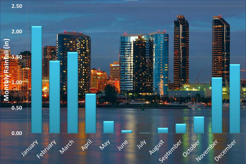
5 SAN DIEGO PRECIPITATION

6 ATMOSPHERIC RIVERS (Pineapple Express)

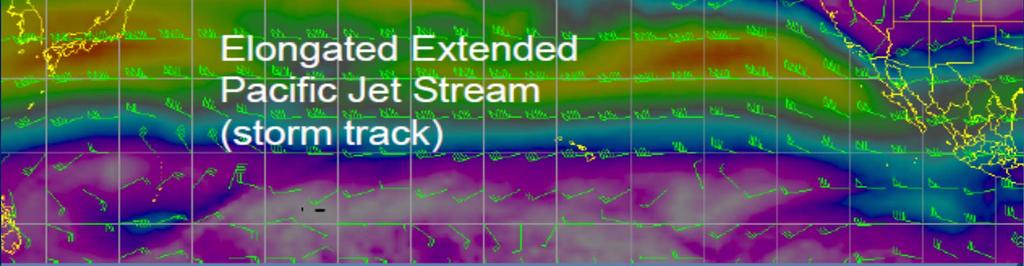
7 ATMOSPHERIC RIVERS January 3-7 Jet Stream

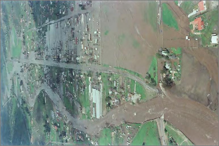
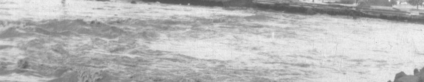
8 Qualcomm Stadium in Mission Valley during the 2010 Flooding Event


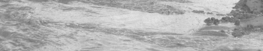
9 River Ridge Golf Course in Mission Valley during the 2010 Flooding Event

10 Mission Center Road in Mission Valley during the 2010 Flooding Event

11


12 HEC-RTS OVERVIEW HEC-RTS is the Hydrologic Engineering Center s Real-Time Simulation program HEC-RTS is a publically avaliable version of the Corps Water Managment System (CWMS) that runs on a single computer without using an Oracle database or a UNIX Server
 Hydrology (HEC-HMS) Reservoir operations (HEC-ResSim) River hydraulics (HEC-RAS) Flood impact/economic analysis")
13 HEC-RTS OVERVIEW HEC-RTS provides support for decision making using any combination of the following models: Meteorology (MFP) Hydrology (HEC-HMS) Reservoir operations (HEC-ResSim) River hydraulics (HEC-RAS) Flood impact/economic analysis (HEC-FIA)

14 METEROLOGIC MODEL (MFP) The Meteorologic Forecast Processor (MFP) combines observed precipitation with future precipitation scenarios The San Diego River HEC-RTS model creates gridded rainfall datasets from 26 point precipitation gages located throughout the watershed and combines these with future rainfall derived from the National Weather Service QPFs (Quantitative Precipitation Forecasts) Manually forecasted precipitation can also be input (e.g. No Future Rainfall)

15 HYDROLOGY MODEL (HEC-HMS) Rainfall runoff calculations are computed using the hydrologic modeling software HEC-HMS The watershed was divided into 49 subbasins Constant-Deficit Loss Method Gridded ModClark Transformation Method Muskingum Routing Method Recession Baseflow Method
16 HYDROLOGY MODEL (HEC-HMS) Two calibration events and one validation event were used to develop a single set of parameters to be used in the HEC-RTS hydrology model (Dec 2004, Dec 2010, Feb 2011) Three USGS stream flow gages as well as computed inflow into the San Vicente and El Capitan Reservoirs were used for the calibration process San Diego River Fashion Valley gage 2010 Event San Diego River Santee Gage 2004 Event

17 HYDRAULIC MODEL (HEC-RAS) River Hydraulics are computed with hydraulic modeling software HEC-RAS Hydrographs produced by the HEC-HMS hydrology model are used as inflow boundary conditions in the unsteady HEC- RAS model The unsteady RAS model for the San Diego River covers over 75 miles of river reach has over 60 culverts/bridges and 3 reservoirs with inline structures The entire main reach of the San Diego River along with San Vicente, Boulder, Forester and Los Coches tributaries are modeled


18 HEC-RAS will compute water surface profiles and stage hydrographs along with inundation boundaries and depth maps HYDRAULIC MODEL (HEC-RAS)
 is the primary framework of RTS and controls the")

19 HEC-RTS MODULES The Control and Visualization Interface (CAVI) is the primary framework of RTS and controls the other functional modules. Watershed Setup Module Data Acquisition Module Data Visualization Module Model Interface Module

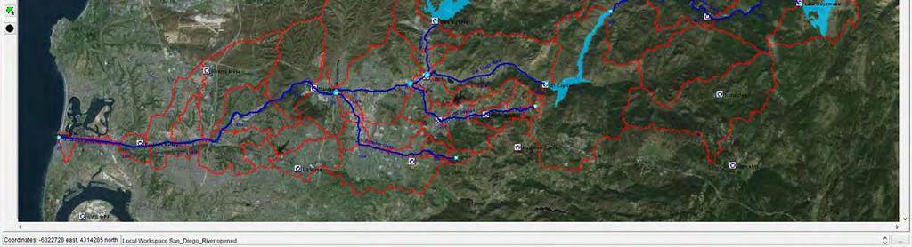
20 WATERSHED SETUP
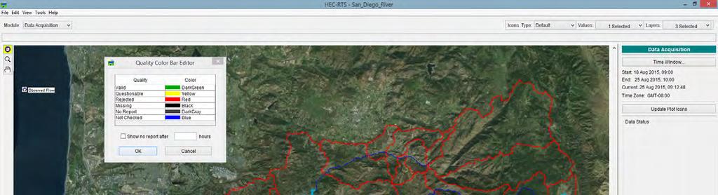
21 DATA ACQUISITION
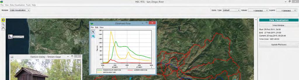
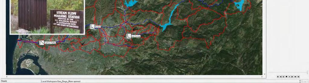
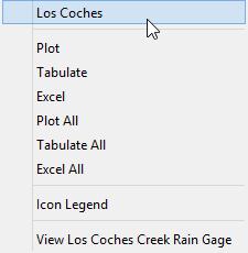
22 DATA VISUALIZATION

23 MODEL INTERFACE


24 ADDITIONAL HEC-RTS FEATURES The use of custom scripts and a script editor allows the user to create custom features in HEC-RTS such as: Auto Schedule Data collection processing Auto schedule forecast simulations to be run an a daily basis Automatic report generation and posting from user specified locations

25 IMPLEMENTATION AND NEXT STEPS Website to host static floodplain maps for quick reference Set up of system and data links on County workstation Implementation of threshold warnings at select locations and texting to emergency managers Development of a user manual Customized on-site training for County staff
26 QUESTIONS?
Risk. Management Center
 Risk Hydro-Metrologic Modeling Tools for Water Management and Analysis Management Center US Army Corps of Engineers William Charley Hydrologic Engineering Center Institute for Water Resources June 2016
A Federal Family Comes Together Association of State Floodplain Managers Conference
 A Federal Family Comes Together 2016 Association of State Floodplain Managers Conference Region 6 by the Numbers 5 States 5 USGS Offices 6 USACE Districts 6 HUC2 Regions 40 HUC4 Subregions 403 HUC8 Watersheds
Hydrologic Engineering Center. Training Course on. Hydrologic Modeling with HEC-HMS. Davis, CA. Course Description
 Hydrologic Engineering Center Training Course on Hydrologic Modeling with HEC-HMS Davis, CA Course Description The course provides an introduction to HEC-HMS for new users, focusing both on using the program
Hydrologic Engineering Center. Training Course on. Hydrologic Modeling with HEC-HMS April 2018 Davis, CA. Course Description
 Hydrologic Engineering Center Training Course on Hydrologic Modeling with HEC-HMS 23-27 April 2018 Davis, CA Course Description The course provides an introduction to HEC-HMS for new users, focusing both
Hydrologic Calibration:
 Hydrologic Calibration: UPDATE OF EFFECTIVE HYDROLOGY FOR MARYS CREEK October 2010 Agenda Background Hydrologic model Calibrated rainfall Hydrologic calibration 100 year discharges, Existing Conditions
Bexar County Flood Warning System. Curtis Beitel, PE, CFM, Anthony Henry and Wayne Tschirhart, PE, PMP
 Bexar County Flood Warning System Curtis Beitel, PE, CFM, Anthony Henry and Wayne Tschirhart, PE, PMP Software Overview 2 Processes Hydrometric DB Event Manager Automatic Low = Every 6 hours High = Every
Introduction to HEC HMS. Daene C. McKinney
 CE 374 K Hydrology Introduction to HEC HMS Daene C. McKinney Hydrologic Engineering Center U.S. Army Corps ofengineers (USACE) Hydrologic Engineering Center (HEC) Formed 1964 to institutionalize the technical
Using high flows from, or in anticipation of, rainfall or snowmelt, for managed aquifer recharge on agricultural lands and working landscapes
 Using high flows from, or in anticipation of, rainfall or snowmelt, for managed aquifer recharge on agricultural lands and working landscapes More competition over surface water storage Potential surface
San Luis Obispo Creek Watershed Hydrologic Model Inputs
 Jeff Werst San Luis Obispo County Department of Public Works 1050 Monterey Street San Luis Obispo CA 93408 December 14, 2007 Subject: San Luis Obispo Creek Watershed Hydrology and Hydraulic Model Dear
Integrating HEC HMS generated flow hydrographs with FLO-2D. Nanda Meduri, PE, PMP, CFM Seth Lawler Venkata Dinakar Nimmala, CFM
 Integrating HEC HMS generated flow hydrographs with FLO-2D Nanda Meduri, PE, PMP, CFM Seth Lawler Venkata Dinakar Nimmala, CFM Focus of this Presentation Introduction Methodology Challenges & Solutions
Autumn semester of Prof. Kim, Joong Hoon
 1 Autumn semester of 2010 Prof. Kim, Joong Hoon Water Resources Hydrosystems System Engineering Laboratory Laboratory 2 A. HEC (Hydrologic Engineering Center) 1 Established in the U.S. Army Corps of Engineers(USACE)
2
 1 2 3 4 5 6 The program is designed for surface water hydrology simulation. It includes components for representing precipitation, evaporation, and snowmelt; the atmospheric conditions over a watershed.
RAINFALL-RUNOFF STUDY FOR SINGAPORE RIVER CATCHMENT
 10 th International Conference on Hydroinformatics HIC 2012, Hamburg, GERMANY RAINFALL-RUNOFF STUDY FOR SINGAPORE RIVER CATCHMENT CHI DUNG DOAN (1)(3), JIANDONG LIU (1), SHIE-YUI LIONG (1), ADRI VERWEY
Abstract. What is big data? Successfully overcoming big data and big analysis challenges for the California Central Valley Hydrology Study
 Successfully overcoming big data and big analysis challenges for the California Central Valley Hydrology Study At left: San Joaquin River Basin reservoir operation model schematic. The model includes 35
1 THE USGS MODULAR MODELING SYSTEM MODEL OF THE UPPER COSUMNES RIVER
 1 THE USGS MODULAR MODELING SYSTEM MODEL OF THE UPPER COSUMNES RIVER 1.1 Introduction The Hydrologic Model of the Upper Cosumnes River Basin (HMCRB) under the USGS Modular Modeling System (MMS) uses a
5/25/2017. Overview. Flood Risk Study Components HYDROLOGIC MODEL (HEC-HMS) CALIBRATION FOR FLOOD RISK STUDIES. Hydraulics. Outcome or Impacts
 CALIBRATION FOR FLOOD RISK STUDIES. Hydraulics. Outcome or Impacts") HYDROLOGIC MODEL (HEC-HMS) CALIBRATION FOR FLOOD RISK STUDIES C. Landon Erickson, P.E.,CFM Water Resources Engineer USACE, Fort Worth District April 27 th, 2017 US Army Corps of Engineers Overview Flood
HYDROLOGIC MODEL (HEC-HMS) CALIBRATION FOR FLOOD RISK STUDIES C. Landon Erickson, P.E.,CFM Water Resources Engineer USACE, Fort Worth District April 27 th, 2017 US Army Corps of Engineers Overview Flood
A Hydrologic Study of the. Ryerson Creek Watershed
 A Hydrologic Study of the Ryerson Creek Watershed Dave Fongers Hydrologic Studies Unit Land and Water Management Division Michigan Department of Environmental Quality May 8, 2002 Table of Contents Summary...2
Hydrologic Modeling System (HEC-HMS) Adaptions for Ontario
 Adaptions for Ontario") Hydrologic Modeling System (HEC-HMS) Adaptions for Ontario Bill Scharffenberg, PhD HEC-HMS Lead Developer 6 March 2018 Floodplain Mapping Knowledge Transfer Workshop Vaughan, Ontario How We View Our Role
Hydrologic Modeling System (HEC-HMS) Adaptions for Ontario Bill Scharffenberg, PhD HEC-HMS Lead Developer 6 March 2018 Floodplain Mapping Knowledge Transfer Workshop Vaughan, Ontario How We View Our Role
Distribution Restriction Statement Approved for public release; distribution is unlimited.
 CECW-EH-Y Regulation No. 1110-2-1464 Department of the Army U.S. Army Corps of Engineers Washington, DC 20314-1000 Engineering and Design HYDROLOGIC ANALYSIS OF WATERSHED RUNOFF Distribution Restriction
Hydrologic Modeling System HEC-HMS
 Hydrologic Modeling System HEC-HMS Applications Guide June 2017 Approved for Public Release Distribution Unlimited CPD-74C REPORT DOCUMENTATION PAGE Form Approved OMB No. 0704-0188 The public reporting
DEVELOPMENT OF A HYDRO-GEOMORPHIC MODEL FOR THE LAGUNA CREEK WATERSHED
 DEVELOPMENT OF A HYDRO-GEOMORPHIC MODEL FOR THE LAGUNA CREEK WATERSHED Agenda Background Hydro-Geomorphic Modeling Methodology HEC-HMS Modeling How is the Model Used Background Proposition 50 Grant Funding
Hypothetical Flood Computation for a Stream System
 US Army Corps of Engineers Hydrologic Engineering Center Hypothetical Flood Computation for a Stream System December 1968 Approved for Public Release. Distribution Unlimited. TP-12 REPORT DOCUMENTATION
Hydrologic Modeling System HEC-HMS
 Hydrologic Engineering Center Hydrologic Modeling System HEC-HMS Applications Guide December 2002 Approved for Public Release Distribution Unlimited CPD-74C REPORT DOCUMENTATION PAGE Form Approved OMB
GISHYDRO: Developing Discharges and Watershed Parameters
 GISHYDRO: Developing Discharges and Watershed Parameters A Case Study with Baltimore City Watersheds by Mathini Sreetharan, Ph.D., P.E., CFM, Dewberry, VA Kim Dunn, P.E., CFM, Dewberry, PA Baltimore City
Training Course Brochure Building Capacity in Rural & Urban Water Management
 Training Course Brochure 2015 Building Capacity in Rural & Urban Water Management Introduction The WastePro Academy seeks to encourage the use of desktop software applications in the water and environmental
Estimating the 100-year Peak Flow for Ungagged Middle Creek Watershed in Northern California, USA
 American Journal of Water Resources, 2014, Vol. 2, No. 4, 99-105 Available online at http://pubs.sciepub.com/ajwr/2/4/3 Science and Education Publishing DOI:10.12691/ajwr-2-4-3 Estimating the 100-year
Alternative Approaches to Water Resource System Simulation
 US Army Corps of Engineers Hydrologic Engineering Center Alternative Approaches to Water Resource System Simulation May 1972 Approved for Public Release. Distribution Unlimited. TP-32 REPORT DOCUMENTATION
Suspended Sediment Discharges in Streams
 US Army Corps of Engineers Hydrologic Engineering Center Suspended Sediment Discharges in Streams April 1969 Approved for Public Release. Distribution Unlimited. TP-19 REPORT DOCUMENTATION PAGE Form Approved
U.S. Army Corps of Engineers and RiverWare. Fort Worth District Building Strong!
 U.S. Army Corps of Engineers and RiverWare USACE Overview 38 district/division offices for civil works for water resources and environmental 37,000 employees $5 billion annual civil works mission Military
DEVELOPMENT OF FLOOD INUNDATION MAP FOR BAGO RIVER BASIN USING DIFFERENT MODELS. Presented by. Dr.Win Win Zin Professor YTU
 DEVELOPMENT OF FLOOD INUNDATION MAP FOR BAGO RIVER BASIN USING DIFFERENT MODELS Presented by Dr.Win Win Zin Professor YTU 26 th Sept 2018 INTRODUCTION Flood inundation modeling involves hydrologic modeling
SECTION III: WATERSHED TECHNICAL ANALYSIS
 Trout Creek Watershed Stormwater Management Plan SECTION III: WATERSHED TECHNICAL ANALYSIS A. Watershed Modeling An initial step this study of the Trout Creek watershed was the selection of a stormwater
Simulation of Daily Streamflow
 US Army Corps of Engineers Hydrologic Engineering Center Simulation of Daily Streamflow April 1968 Approved for Public Release. Distribution Unlimited. TP-6 REPORT DOCUMENTATION PAGE Form Approved OMB
Computer Determination of Flow Through Bridges
 US Army Corps of Engineers Hydrologic Engineering Center Computer Determination of Flow Through Bridges July 1970 Approved for Public Release. Distribution Unlimited. TP-20 REPORT DOCUMENTATION PAGE Form
Hydrostatistics Principles of Application
 US Army Corps of Engineers Hydrologic Engineering Center Hydrostatistics Principles of Application July 1969 Approved for Public Release. Distribution Unlimited. TP-15 REPORT DOCUMENTATION PAGE Form Approved
The South Carolina Extreme Rainfall Analysis-Understanding the Storm and Implications for Dam Safety
 The South Carolina Extreme Rainfall Analysis-Understanding the Storm and Implications for Dam Safety Bill Kappel Applied Weather Associates Joe Bellini, PE, PH, D.WRE, CFM Aterra Solutions Dam Safety Conference,
A Finite Difference Method for Analyzing Liquid Flow in Variably Saturated Porous Media
 US Army Corps of Engineers Hydrologic Engineering Center A Finite Difference Method for Analyzing Liquid Flow in Variably Saturated Porous Media April 1970 Approved for Public Release. Distribution Unlimited.
Pilot Study for Storage Requirements for Low Flow Augmentation
 US Army Corps of Engineers Hydrologic Engineering Center Pilot Study for Storage Requirements for Low Flow Augmentation April 1968 Approved for Public Release. Distribution Unlimited. TP-7 REPORT DOCUMENTATION
SAN BERNARD RIVER WATER QUALITY MODEL UPDATE. August 18, 2011
 SAN BERNARD RIVER WATER QUALITY MODEL UPDATE August 18, 2011 Agenda Model Set-up Watershed model Watershed delineations Generate model input files & establish coefficients Receiving Water model Establish
Estimation of Hydrological Outputs using HEC-HMS and GIS
 Nigerian Journal of Environmental Sciences and Technology (NIJEST) www.nijest.com ISSN (Print): 2616-051X ISSN (electronic): 2616-0501 Vol 1, No. 2 July 2017, pp 390-402 Estimation of Hydrological Outputs
Appendix VI: Illustrative example
 Central Valley Hydrology Study (CVHS) Appendix VI: Illustrative example November 5, 2009 US Army Corps of Engineers, Sacramento District Prepared by: David Ford Consulting Engineers, Inc. Table of contents
Climate and Land Use Consequences to 100-Year Flooding
 Climate and Land Use Consequences to 100-Year Flooding Robert Roseen D.WRE, PE, PhD, Ann Scholz, PE, CPSWQ, Thomas Ballestero, PhD, PE, PH, UNH Stormwater Center Nebraska Post- Construction Stormwater
Brian Rast, PE, CFM, PMP Lead Silver Jackets Coordinator, Kansas and Missouri Kris Lander, PE, CFM Hydrologist. June 4, 2015
 Presentation to the Association of State Floodplain Managers Interagency Partnering for Flood Forecast Inundation Maps Brian Rast, PE, CFM, PMP Lead Silver Jackets Coordinator, Kansas and Missouri Kris
A&M WATERSHED MODEL USERS MANUAL WATER RESOURCES ENGINEERING
 TWRI Special Report 90-1 A&M WATERSHED MODEL USERS MANUAL by: Wesley P. James Phillip W. Winsor, John F. Bell Melvin G. Spinks, Alfred J. Garcia Dan Pridal, John Warinner Kelly Kaatz, Veronica Morgan Mike
SECTION IV WATERSHED TECHNICAL ANALYSIS
 A. Watershed Modeling SECTION IV WATERSHED TECHNICAL ANALYSIS An initial step in the preparation of this stormwater management plan was the selection of a stormwater simulation model to be utilized. It
Forecast Informed Reservoir Operations (FIRO) ERDC Hydrologic Investigations
 ERDC Hydrologic Investigations") Forecast Informed Reservoir Operations (FIRO) ERDC Hydrologic Investigations Briefing, May 31, 2017 Background The US Army Corps of Engineers (USACE) operates reservoirs primarily for flood control, with
Forecast Informed Reservoir Operations (FIRO) ERDC Hydrologic Investigations Briefing, May 31, 2017 Background The US Army Corps of Engineers (USACE) operates reservoirs primarily for flood control, with
Technical Memorandum. Hydraulic Analysis Smith House Flood Stages. 1.0 Introduction
 Technical Memorandum Hydraulic Analysis Smith House Flood Stages 1.0 Introduction Pacific International Engineering (PIE) performed a hydraulic analysis to estimate the water surface elevations of the
Assessing the Risk of 100-year Freshwater Floods in the Lamprey River Watershed of New Hampshire Resulting from Changes in Climate and Land Use
 Assessing the Risk of 100-year Freshwater Floods in the Lamprey River Watershed of New Hampshire Resulting from Changes in Climate and Land Use Presented by: Ann Scholz, PE, CPSWQ Advisor: Dr. Robert Roseen,
Flood Control Planning Below Alluvial Fans
 Flood Control Planning Below Alluvial Fans Presenter: Contributors: Aric Torreyson P.E., Program Manager, Tetra Tech Inc. Nathan Schreiner, P.E., Project Manager, Tetra Tech Inc. Tesfaye Demissie, P.E.,
Vulnerability of Infrastructure due to Climate Change
 1 Vulnerability of Infrastructure due to Climate Change A Case Study of London, Ontario Elisabeth Bowering and Angela Peck M. E. Sc. Candidates Slobodan P. Simonovic, Professor The University of Western
JOURNAL OF APPLIED SCIENCES RESEARCH
 Copyright 2015, American-Eurasian Network for Scientific Information publisher JOURNAL OF APPLIED SCIENCES RESEARCH ISSN: 1819-544X EISSN: 1816-157X JOURNAL home page: http://www.aensiweb.com/jasr Published
SOUTHEAST TEXAS CONTINUING EDUCATION
 EXAM No. 118 FLOOD - RUNOFF ANALYSIS 1. Information gained from flood - runoff analysis includes which one: A. Stage, discharge, volume. B. Measure depth, volume. C. Velocity, depth, storm occurrence.
Flood Modelling For Peri Urban Areas in Adyar River
 Flood Modelling For Peri Urban Areas in Adyar River Saranya VP 1 Assistant Professor, Department of Civil Engineering, Bannari Amman Institute of Technology, Erode, India 1 ABSTRACT: Water is essential
IMPROVED MODELING OF THE GREAT PEE DEE RIVER: DOCUMENTATION IN SUPPORT OF FEMA APPEAL. Horry County, South Carolina
 IMPROVED MODELING OF THE GREAT PEE DEE RIVER: DOCUMENTATION IN SUPPORT OF FEMA APPEAL Horry County, South Carolina July 15, 2016 CONTENTS 1 Introduction... 2 2 Hydrology... 3 3 HEC-RAS Model... 7 3.1 Cross
ADVANCED APPLICATIONS OF HEC-HMS
 Hydrologic Engineering Center Training Course on ADVANCED APPLICATIONS OF HEC-HMS 18 22 April 2016 Davis, California Course Objectives The course covers a variety of areas that go beyond the Basic HEC-HMS
Hydrology and Hydraulic Modeling for Flash Floods Risk Assessment and Mapping
 Hydrology and Hydraulic Modeling for Flash Floods Risk Assessment and Mapping A Methodology Proposal Konstantinos Papatheodorou Eleni A. Tzanou Konstantinos Ntouros Flash Flood Assessment From Regional
Table of Contents. Table of Figures
 Appendix A: Modeling Report Little Manatee WBID: 1790 Nutrients and Dissolved Oxygen September 30, 2009 Table of Contents 1. WATERSHED DESCRIPTION... 1 2. TMDL TARGETS... 2 3. MODELING APPROACH... 2 3.1.
Title Advanced Hydraulic Modeling to Support Emergency Action Plans
 Title Advanced Hydraulic Modeling to Support Emergency Action Plans Abstract Freese and Nichols, Inc. (FNI) developed an Emergency Action Plan (EAP) for a Levee Improvement District (LID) located in a
DES MOINES RIVER RESERVOIRS WATER CONTROL PLAN UPDATES IOWA ASCE WATER RESOURCES DESIGN CONFERENCE
 DES MOINES RIVER RESERVOIRS WATER CONTROL PLAN UPDATES 237 237 237 217 217 217 200 200 200 0 0 0 163 163 163 131 132 122 80 119 27 252 174.59 110 135 120 112 92 56 IOWA ASCE WATER RESOURCES DESIGN CONFERENCE
Distributed Hydrological Modeling for NWS Flash Flood Operations
 Distributed Hydrological Modeling for NWS Flash Flood Operations HVT Animation and GIS Products Lynn E. Johnson CSU-CIRA, ESRL-PSD James Halgren RTI-International Tim Coleman CU-CIRES, ESRL-PSD Export
Appendix C. Demonstration Model
 Appendix C Demonstration Model Connecticut River Partnership Demonstration hydrologic/dam operations models Overview The Nature Conservancy, together with partners, has identified an altered flow regime
Estimation of Infiltration Parameter for Tehri Garhwal Catchment
 Estimation of Infiltration Parameter for Tehri Garhwal Catchment Ashish Bhatt 1 H L Yadav 2 Dilip Kumar 3 1 UG Student, Department of civil engineering, G B Pant Engineering College, Pauri, UK-246194 2,3
OVERVIEW OF RESERVOIR OPERATIONS AND FLOOD RISK MANAGEMENT
 OVERVIEW OF RESERVOIR OPERATIONS AND FLOOD RISK MANAGEMENT 255 255 255 237 237 237 0 0 0 217 217 217 163 163 163 200 200 200 COLUMBIA RIVER BASIN 131 132 122 239 65 53 80 119 27 110 135 120 252 174.59
HEC-HMS Modeling Summary: Cherry Creek Basin Tributary to Cherry Creek Dam
 HEC-HMS Modeling Summary: Cherry Creek Basin Tributary to Cherry Creek Dam October 2008 Prepared by: U.S. Army Corps of Engineers, Omaha District Hydrology Section - Hydrologic Engineering Branch 66 Capitol
Forecast Informed Reservoir Operations Lake Mendocino Demonstration Project
 Forecast Informed Reservoir Operations Lake Mendocino Demonstration Project Improving S2S Precipitation Forecasting - WSWC May 16, 2018 San Diego, CA Jay Jasperse, P.E. Chief Engineer Sonoma County Water
JD 14 Project Area Project Team Meeting
 Middle-Snake-Tamarac Rivers Watershed District JD 14 Project Area Project Team Meeting January 31, 2017 RCPP Study Process 1. INITIATE PLANNING 1. Discuss purpose and need for project with sponsors/initiate
Watershed Modeling of Copper Loads to San Francisco Bay
 Watershed Modeling of Copper Loads to San Francisco Bay Tony Donigian AQUA TERRA Consultants Brake Pad Partnership Stakeholder Conference July 31, 2007 Watershed Model Objectives - Provide daily loadings
CEIWR-HEC Engineering Assistance. Summary of Recent Activities and FY 2017 Outlook
 CEIWR-HEC Engineering Assistance Summary of Recent Activities and FY 2017 Outlook September 2016 Overview The requested engineering and modeling support for FY 2017 has changed. We added new capabilities
Water Data Needs and Applications in the Private Sector. Robert Annear, Vice President, Ph.D., P.E. Water is our nature
 Water Data Needs and Applications in the Private Sector Robert Annear, Vice President, Ph.D., P.E. Water is our nature GRN Forum: Global Water - 2010 and Beyond Oct 21 2010 - Oct 22 2010 Introduction Our
Development of a GIS Tool for Rainfall-Runoff Estimation
 Development of a GIS Tool for Rainfall-Runoff Estimation Ashraf M. Elmoustafa * M. E. Shalaby Ahmed A. Hassan A.H. El-Nahry Irrigation and Hydraulics Department, Ain Shams University, Egypt NARSS, Egypt
Forecast Informed Reservoir Operations An Opportunity to Improve the Resiliency of our Water Supply
 Forecast Informed Reservoir Operations An Opportunity to Improve the Resiliency of our Water Supply Western States Water Council S2S Precipitation Forecasting May 17, 2017 San Diego, California Jay Jasperse,
Project Summary: - Hydrologic Models. - LiDAR Based - 10 Synthetic Events - No Historic Events - 100yr Runoff is Largest - Assumes Even Rainfall
 Project Summary: - Hydrologic Models Phase 2 Underway Nearly Completed (Park/Pembina EOY) - LiDAR Based - 10 Synthetic Events - No Historic Events - 100yr Runoff is Largest - Assumes Even Rainfall Phase
CONTINUOUS RAINFALL-RUN OFF SIMULATION USING SMA ALGORITHM
 CONTINUOUS RAINFALL-RUN OFF SIMULATION USING SMA ALGORITHM INTRODUCTION Dr. R N Sankhua Director, NWA, CWC, Pune In this continuous rainfall-runoff simulation, we will perform a continuous or long-term
PWD s Systematic Watershed-wide Approach to Stormwater Mgmt.
 PWD s Systematic Watershed-wide Approach to Stormwater Mgmt. Jeffrey Featherstone, PhD Director, Center for Sustainable Communities, Temple University Paul DeBarry, PE, PH, GISP, D.WRE Director, Geospatial
Flood risk management with HEC-WAT and the FRA compute option
 Flood risk management with HEC-WAT and the FRA compute option Christopher Dunn 1,a, Penni Baker 2 and Matthew Fleming 3 1 Director - U.S. Army Corps of Engineers, Institute for Water Resources, Hydrologic
Sacramento and San Joaquin river basins: Procedures for hydrologic analysis September 9, 2008
 Sacramento and San Joaquin river basins: Procedures for hydrologic analysis September 9, 2008 David Ford Consulting Engineers, Inc. 2015 J Street, Suite 200 Sacramento, CA 95811 Ph. 916.447.8779 Fx. 916.447.8780
HEC-HMS Development in Support of Russian River Watershed Assessment
 HEC-HMS Development in Support of Russian River Watershed Assessment by Zhonglong Zhang and Billy E. Johnson PURPOSE: The objective of this technical note is to briefly describe the Hydrologic Engineering
Dulcepamba River Hydrologic and Hydraulic Analysis *
 Dulcepamba River Hydrologic and Hydraulic Analysis * Jeanette Newmiller 1 Wesley Walker 1 William Fleenor 2 Nicholas Pinter 3 August 8, 2017 1 Graduate Student Researcher, Center for Watershed Sciences,
Performance analysis of flood control facilities in São Paulo Metropolitan Region during extreme rainfall events, based on hydrological simulation
 Performance analysis of flood control facilities in São Paulo Metropolitan Region during extreme rainfall events, based on hydrological simulation Graciosa, M.C.P. 1* ; Coelho, G.A. 2 ; Vieira, J.R.S 3.
Outlet Structure Modeling
 Watershed Modeling using HEC-RAS Outlet Structure Modeling Jeff Wickenkamp, P.E., CFM, D.WRE Patrick Lach, P.E. Hey and Associates, Inc. Water Resources, Wetlands and Ecology Outline of Presentation Why
Forecast Informed Reservoir Operations An Opportunity to Improve the Resiliency of our Water Supply
 Forecast Informed Reservoir Operations An Opportunity to Improve the Resiliency of our Water Supply 2016 International Atmospheric Rivers Conference August 8 2016 Jay Jasperse, Chief Engineer Sonoma County
Application the SWAT model for Extreme Urban Flash Floods in Seoul
 Application the SWAT model for Extreme Urban Flash Floods in Seoul 18 July 2013 International SWAT Conference, Toulouse, France Hyung Kyung Joh / Researcher / Weather Information Service Engine Division
Recent Activities of the Maryland Hydrology Panel
 Recent Activities of the Maryland Hydrology Panel Kaye L. Brubaker, University of Maryland, College Park Wilbert O. Thomas, Jr., Michael Baker International MAFSM 12 th Annual Conference Linthicum, Maryland
Cokato Lake (86-263) Wright County. Hydrologic Investigation
 Wright County. Hydrologic Investigation") Cokato Lake (86-263) Wright County Hydrologic Investigation April 14, 2005 Cokato Lake (86-263) Wright County Hydrologic Investigation April 14, 2005 Problem Statement In recent years, heavy rainfall has
Cokato Lake (86-263) Wright County Hydrologic Investigation April 14, 2005 Cokato Lake (86-263) Wright County Hydrologic Investigation April 14, 2005 Problem Statement In recent years, heavy rainfall has
Climate and Land Use Consequences to 100-Year Flooding
 Climate and Land Use Consequences to 100-Year Flooding Presented by: Ann Scholz, PE, CPSWQ Grad Student, University of New Hampshire Robert Roseen & Thomas Ballestero, UNH Stormwater Center Michael Simpson,
in Hydrologic Engineering Summer 2007
 in Hydrologic Engineering Summer 2007 Director's Comments By Christopher N. Dunn, P.E. It has been six months since our last HEC Newsletter and while we try to update the newsletter quarterly, a biannual
Hydromodification Computer Modeling
 Hydromodification Computer Modeling Douglas Beyerlein, P.E. Clear Creek Solutions, Inc. 15800 Village Green Drive #3 Mill Creek, WA 98012 beyerlein@clearcreeksolutions.com Phone: 425.892.6454 Introduction
Control and mitigation of floods along transbasin diversion channel of Mekong tributaries and Nan river, Thailand
 Control and mitigation of floods along transbasin diversion channel of Mekong tributaries and Nan river, Thailand Tawatchai Tingsanchali* School of Civil Engineering, Asian Institute of Technology, P.O.Box
Levees and Extreme Water Levels in the Southern Louisiana
 Proactive By Design. Our Company Commitment Levees and Extreme Water Levels in the Southern Louisiana ASFPM 2015 Conference Kenneth D. Hunu, PE GZA GeoEnvironmental, Inc. Page 1 Hydrologic Setting Page
Integrated Watershed Modeling of the Alewife Brook: Developing the Right Tools for Climate Change Preparedness
 Integrated Watershed Modeling of the Alewife Brook: Developing the Right Tools for Climate Change Preparedness David Bedoya, PhD, PE Yovanni Cataño-Lopera, PhD, PE Nicholas Stepina, PE Date Presentation
San Antonio Water System Mitchell Lake Constructed Wetlands Below the Dam Preliminary Hydrologic Analysis
 San Antonio Water System enhancement. This recommendation was based on limited water quality data provided by SAWS and using a free-water surface constructed wetland with approximately 112 acres of wetted
COUNTY OF KANE. Kishwaukee River Headwaters Study Stakeholder Meeting Monday, February 26, :30 am Hampshire Village Hall
 COUNTY OF KANE ENVIRONMENTAL AND BUILDING MANAGEMENT Timothy Harbaugh, P.E., DEE Director County Government Center 719 Batavia Avenue Geneva, IL 60134 www.co.kane.il.us Environmental Management: (630)
Event and Continuous Hydrological Modeling with HEC- HMS: A Review Study
 Event and Continuous Hydrological Modeling with HEC- HMS: A Review Study Sonu Duhan *, Mohit Kumar # * M.E (Water Resources Engineering) Civil Engineering Student, PEC University Of Technology, Chandigarh,
Note that the Server provides ArcGIS9 applications with Spatial Analyst and 3D Analyst extensions and ArcHydro tools.
 Remote Software This document briefly presents the hydrological and hydraulic modeling software available on the University of Nice Server with Remote Desktop Connection. Note that the Server provides
CLIMATE CHANGE RESILIENCY AND STORM WATER MANAGEMENT: A FEDERAL SITE'S PERSPECTIVE
 drhgfdjhngngfmhgmghmghjmghfmf IAFSM 2016 ANNUAL CONFERENCE TINLEY PARK, ILLINOIS CLIMATE CHANGE RESILIENCY AND STORM WATER MANAGEMENT: A FEDERAL SITE'S PERSPECTIVE PETER LYNCH Environmental Engineer Argonne
Evaluation of the effects of underlying surface change on catchment hydrological response using the HEC-HMS model
 Evolving Water Resources Systems: Understanding, Predicting and Managing Water Society Interactions Proceedings of ICWRS2014, Bologna, Italy, June 2014 (IAHS Publ. 364, 2014). 145 Evaluation of the effects
Russian River Watershed Hydrograph Separation using Stable Isotopes and Natural Geochemical Tracers. July 28, 2018
 Russian River Watershed Hydrograph Separation using Stable Isotopes and Natural Geochemical Tracers Stephen J. Turnbull1, Charles W. Downer1, Anna M. Wilson2, Carolyn J. Ellis2, Brian Henn2, and Hari T.
Bear Creek Dam and Reservoir NID# OR Douglas County, Oregon
 Bear Creek Dam and Reservoir NID# OR00614 Douglas County, Oregon FINAL Dam Breach Study and Flood Inundation Mapping March, 2009 Prepared for: The City of Drain, Oregon 129 West C Avenue Drain, OR 97435
Technical Memorandum No River Geometry
 Pajaro River Watershed Study in association with Technical Memorandum No. 1.2.5 River Geometry Task: Collection and Analysis of River Geometry Data To: PRWFPA Staff Working Group Prepared by: J. Schaaf