An Integrated GPS-based Mobile Data Collection and Web-based GIS Platform for Supporting GDOT s Pavement Rehabilitation and Design Processes
|
|
|
- Primrose Evans
- 6 years ago
- Views:
Transcription

1 An Integrated GPS-based Mobile Data Collection and Web-based GIS Platform for Supporting GDOT s Pavement Rehabilitation and Design Processes Zhaohua Wang Georgia Institute of Technology Steve Pahno, Teague Buchanan Georgia Department of Transportation May 8, 2014
2 Acknowledgement Research project sponsored by the Georgia Department of Transportation (GDOT) Other key persons GDOT Abdallah Jubran (AJ), State Pavement Engineer James Turner, Pavement Test Engineer Scott Gallman, Pavement Evaluation Engineer (retired) Gregory Leggett, Pavement Evaluation Engineer Timothy Poe, Enterprise GIS Team Leader Sanjeev Devarapalli, Software Architect Joshua Ross, (former) GIS Developer Anand Matam, GIS Developer
3 Acknowledgement (cont d) Other key persons Georgia Tech Yichang (James) Tsai, Associate Professor, CO-PI Jian (Roger) Zhao, Research Associate, Software Developer Harini Kumar, Research Associate, Software Developer Balasubramanyam Ganapathi, Research Associate, Software Developer Sundararajan Sarangan, Research Associate, Software Developer Aditya Kadam, Research Associate, Software Developer Mihir Shah, Research Associate, Software Developer
4 Outline GDOT IT development procedures Engineering background System architecture GPS-based mobile data collection A web-based GIS platform Coring data management Extraction and analysis of historical pavement conditions Recommendations for future enhancement
5 Development Procedures (cont d) Reviewed and Approved by OIT Reviewed and Approved by OIT Reviewed and Approved by OIT GaTech performed refinement Business Requirements Architecture Design Database Design System Development System Integration Discussed by OMAT & GaTech Existing data sources and requirements from OIT Discussed by OMAT & GaTech Development environment specified by OIT GaTech worked with OIT on Integration Reviewed and Approved by OIT and OMAT System Testing & Q/A Production OIT and OMAT performed testing


6 Highway Maintenance in GDOT 18,000 centerline miles on the State Highway System 46,000 Lane Miles 1,200 centerline Miles on Interstate 6,000 Lane Miles on Interstate 10% Annual resurfacing/overlay


7 Pavement Evaluation for Rehab design Pavement evaluation for cost-effective rehab design In-service and historical pavement surface distresses Existing pavement structure Material property and crack penetration In-service pavement conditions Existing pavement structure Coring Crack penetration Historical pavement conditions Pavement condition survey


8 Pavement Evaluation Processes In the past In Filed: Paper-pencil data recording; Separate picture taking Disadvantages Error-prone data recording Error-prone report compiling Inconsistent data quality Inaccurate location reference Tedious data utilization Difficult data reuse and data sharing In Office: Manual report compiling; Manual picture organizing GPAM Data Using by Pavement Design Engineers: Manual data search


9 System Architecture/Solution Field Data Collection In-Office Data Transfer Data Uploading PE Other Maps GDOT base maps State routes Incomplete projects Completed projects Online base maps (e.g., Bing map, ESRI maps) COPACES GIS-based Web Platforms


10 GPS-based Mobile Data Collection Accuracy is up to sub-foot.


11 In-Field Image Integration Wi-Fi

12 Data Collected Field-collected data has been uploaded to the central database: 107 projects since 2008 Including 731 cores and more than 4,000 pictures

13 Architecture of Web App 13


14 Project Search


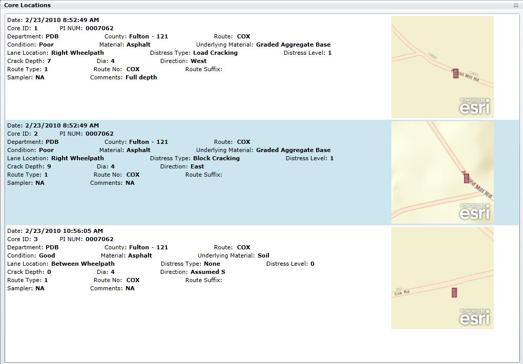
15 Core Search
16 Online Core Data Input Other than the data from PDB, other parties can contribute and easily share their data now. GDOT designated engineer review and approve/reject new data Add core data using web (other offices/contractors)
17 Historical Pavement Condition Data Extraction Define date range (when to when) Define project location (where to where) using GDOT LRS RCLINK (10 digits: county, route type, route number, route suffix) Milepoint from and to RCLINK 1 RCLINK 2

18 Historical Pavement Condition Data Extraction (cont d) Interactive tool was developed to visually locate projects without knowing RCLINK code

19 Historical Pavement Condition Data Analysis


20 Historical Pavement Condition Data Analysis (cont d)


21 Summary: New Pavement Evaluation Processes From now on In Filed: GPS-base handheld data collection; Real-time picture integration Advantages Consistent data format and data quality Accurate location reference (Lon. & Lat.) GIS-based web application for data PE management, report generation, and data analysis Other end users can also share their own data Other data sources (e.g. COPACES) are integrated COPACES In Office: Automatic report compiling; Database usage; Automatic picture organizing Data Using by Pavement Design Engineers: GISbase web application
22 Benefits Increase the return on investment (ROI) Better managing the valuable and scarce data (coring data) Better utilizing the existing data (COPACES and map services) Easier data sharing (other than PDB, other users and contributors: Office of Maintenance, Office of Roadway Design, District & Area Offices, and Contractors & Consultants) Directly support GDOT s engineering decision making on pavement rehabilitation and design Improved data accuracy Comprehensive data integration Efficient data retrieval Effective data analysis tools
23 Suggestions on Future Applications The GPS-based field data collection procedures and GIS-based web platform for data management, sharing and reporting can be extended to Soil surveys Testing management activities Bridge foundation investigations Construction audit activities


24 Suggestions on Future Enhancement Use new tablet computers and cloud computing for seamless synchronization between data acquisition and data utilization) Cloud PE
25 Thanks! Q/A
A GPS Enabled Handheld-based Pavement Coring and Condition Evaluation System
 Successful Implementation of A GPS Enabled Handheld-based Pavement Coring and Condition Evaluation System Zhaohua Wang, PhD James Tsai, PhD, PE Georgia Institute of Technology Steve Pahno Georgia Department
Accelerated Sign Inventory and Management
 2015 The AASHTO Subcommittee on Maintenance (SCOM), Des Moines, Iowa Accelerated Sign Inventory and Management Erany Robinson-Perry Assistant State Maintenance Engineer Georgia Department of Transportation
Using GIS to Support Multi-year Pavement MR&R Need Analysis
 Using GIS to Support Multi-year Pavement MR&R Need Analysis Yichang(James) Tsai, Ph.D., P.E. Bo Gao, Ph.D. Candidate Georgia Institute of Technology Bryant Poole, P.E. JT Rabun, P.E. Georgia Department
Georgia DOT Micro-milling and Thin Overlay
 Georgia DOT Micro-milling and Thin Overlay Presented by Yichang (James) Tsai, Ph.D., P.E., Professor Georgia Institute of Technology Erany Robinson-Perry, P.E., Assistant State Maintenance Engineer Georgia
Enhanced Transportation Asset Data Collection Using Video Log Image Pattern Recognition
 Enhanced Transportation Asset Data Collection Using Video Log Image Pattern Recognition James Tsai, Ph.D., P.E. Georgia Institute of Technology March 26, 2007 Acknowledgement to National Academy of Science
Presented by John Hudler Geospatial Group Leader Office of Transportation Data Georgia Department of Transportation
 Presented by John Hudler Geospatial Group Leader Office of Transportation Data Georgia Department of Transportation Collection, Quality Assurance and Reporting of the States roadway and transportation
Esri Roads and Highways An Introduction. Nathan Easley Rahul Rakshit
 Esri Roads and Highways An Introduction Nathan Easley Rahul Rakshit Roads and Highways Linear Referencing for the Transportation Enterprise GIS-enabled LRS platform LRS management LRS editing & maintenance
Office of Transportation Data (OTD)
") Office of Transportation Data (OTD) Paul Tanner State Transp o rtatio n D ata A d m inistrato r Presentation Objectives Why do we collect data? State & Federal Code Requirements Who collects the data?
Office of Transportation Data (OTD) Paul Tanner State Transp o rtatio n D ata A d m inistrato r Presentation Objectives Why do we collect data? State & Federal Code Requirements Who collects the data?
ArcGIS for Transportation. Tom Brenneman, Gary Waters
 ArcGIS for Transportation Tom Brenneman, Gary Waters ArcGIS for Transportation A product for Esri s transportation customers A series of useful maps and apps focused on transportation Organized into modules
Esri Roads and Highways Solution Overview. Eric Floss Transportation Practice Manager
 Esri Roads and Highways Solution Overview Eric Floss Transportation Practice Manager Agenda Esri LRS Solution Briefing Advanced Linear Referencing Support User Interface Experience Open Discussion GIS
Integrating MAP-21 Asset Management Data Using Esri s Roads and Highways. Imagine the result
 Integrating MAP-21 Asset Management Data Using Esri s Roads and Highways Imagine the result 1 17 2012 October ARCADIS 2014 Presenters David Ward Project Manger and Principal Architect for AzDOT Roads and
GIS USE IN PAVEMENT MARKING AND SIGN MANAGEMENT: AN INTEGRATED APPROACH
 GIS USE IN PAVEMENT MARKING AND SIGN MANAGEMENT: AN INTEGRATED APPROACH Omar Smadi 1, Zachary Hans 2, and Neal Hawkins 3 ABSTRACT Geographic information system (GIS) technology is a key component of all
Esri Roads and Highways An Introduction
 Esri International User Conference San Diego, California Technical Workshops July 24, 2012 Esri Roads and Highways An Introduction William Isley Majunu Seran Agenda Product Overview Desktop - Demo: Network
Productivity Management INTELLIGENT COLLABORATION SOLUTION
 Productivity Management INTELLIGENT COLLABORATION SOLUTION Why Productivity Management? Organizations are now challenged with delivering consistent customer experiences across all teams and channels, despite
The Role of PMS in the DOTD Decision Making Process
 The Role of PMS in the DOTD Decision Making Process Christophe N. Fillastre, P.E. CE Louisiana Department of Transportation and Development Section 21, Management Systems and Data Collection Pavement Management
Session Objectives. Inspections Completed to Manage Risk. Session Objectives. Risk Management Motivators
 Session Objectives Gain insight from the session on how mobile inspection systems can be used to reduce risk. Share ideas from experience in implementing mobile technology based systems. Present a comparison
Performing Cost Effective Asset Management Inventories Utilizing GIS. Steve Tyler, Public Works Superintendent Mark Dumford, Consultant
 Performing Cost Effective Asset Management Inventories Utilizing GIS Steve Tyler, Public Works Superintendent Mark Dumford, Consultant Town of Atherton South San Mateo County 5 square miles Approximately
2006 GIS-T T Symposium Columbus Ohio
 2006 GIS-T T Symposium Columbus Ohio GIS in Transportation District 12 - Ohio Dept. of Transportation Steve Henry Management Analyst Supervisor Presentation includes: Part 1: State and District Data Maintenance
Building West Virginia DOT s Geospatial Capabilities:
 Building West Virginia DOT s Geospatial Capabilities: GIS Web Portal And Straight-line Diagram Application Current Status, Upcoming Enhancements, and Integration Marshall Burgess, WVDOT Don Kiel, GeoDecisions
TRANSPORTATION RESEARCH BOARD. Pavement Management Practices in the US and Canada. Monday, July 17, :00-2:30 PM ET
 TRANSPORTATION RESEARCH BOARD Pavement Management Practices in the US and Canada Monday, July 17, 2017 1:00-2:30 PM ET The Transportation Research Board has met the standards and requirements of the Registered
One Maryland One Centerline. GIS-T 2014 May 7, 2014
 One Maryland One Centerline GIS-T 2014 May 7, 2014 Current Road Centerlines in Maryland SHA maintains a statewide centerline Supports HPMS program Represents state and local roads Capturing dual carriageways
TRANSPORTATION RESEARCH BOARD. Pavement Maintenance Programming Using 3D Laser Technology. Monday, March 26, :00-3:30 PM ET
 TRANSPORTATION RESEARCH BOARD Pavement Maintenance Programming Using 3D Laser Technology Monday, March 26, 2018 2:00-3:30 PM ET The Transportation Research Board has met the standards and requirements
Designing and Implementing a GIS- Centric Pavement Management System for the City of Alexandria, VA
 Designing and Implementing a GIS- Centric Pavement Management System for the City of Alexandria, VA Transmap Corporation 614-481-6799 (office) Howard Luxhoj, P.E. President and CEO hluxhoj@transmap.com
Urban Arterial Roads Pavement Data Collection. October 23, 2012 Todd M. Halacy, P.E. VDOT Local Assistance Division
 Urban Arterial Roads Pavement Data Collection October 23, 2012 Todd M. Halacy, P.E. VDOT Local Assistance Division Presentation Topics Background Information: CTB Subcommittee & Local Government Workgroup
Using Random Samples to Assess Roadway Condition. Faith Johnson GIS Specialist, NCDOT
 Using Random Samples to Assess Roadway Condition Faith Johnson GIS Specialist, NCDOT North Carolina Highway System 79,600 miles of state maintained roads Interstate: 1,326 Primary: 13,736 Secondary: 64,522
RIDOT S Statewide Roadway and Asset Data Collection Project
 RIDOT S Statewide Roadway and Asset Data Collection Project ESRI User Conference 2017 Rafiq Basaria, DTS; Daniel Behnke DTS, Shane White, RIDOT Accent image here Primary Image here What is MIRE? Recommended
Pavement Management Systems PMS PAVEMENT MANAGEMENT SYSTEMS OVERVIEW. Dr. Nick Vitillo
 Pavement Management Systems PMS PAVEMENT MANAGEMENT SYSTEMS OVERVIEW Dr. Nick Vitillo PMS CONCEPTS DISCUSSION TOPICS DEFINITION OF PM AND PMS PMS SUBSYSTEMS NETWORK & PROJECT LEVEL PMS PAVEMENT EVALUATION
Asset Management and Data Collection using Digital Video / GPS Data Extraction Techniques
 Asset Management and Data Collection using Digital Video / GPS Data Extraction Techniques TRB 6 th National Conference on Transportation Asset Management Kansas City, Missouri November 2, 2005 Presentation
M.S. Foster & Associates, Inc
 M.S. Foster & Associates, Inc Why GPS Tracking Systems What is Important To You? Improve customer service Real-time tracking, vehicles on a map Increase operating efficiency Driver productivity / compliance
Iowa Pavement Marking Management System: Initial Phases
 Iowa Pavement Marking Management System: Initial Phases Neal R. Hawkins Center for Transportation Research and Education Iowa State University 2900 S. Loop Drive, Suite 3100 Ames, IA 50010 hawkins@iastate.edu
Aprimo Marketing Productivity
 Aprimo Marketing Productivity Why Marketing Productivity? Marketers today face many challenges: they must deliver more personalized experiences across more channels than ever before. While marketing budgets
Questionnaire Survey for Current Practices in Roadway Safety Hardware Asset Management at State Transportation Agencies
 MRUTC Project 8-7: A Methodology for Integrating Roadway Safety Hardware Management into the Overall Highway Asset Management Program Questionnaire Survey for Current Practices in Roadway Safety Hardware
Asset Management For Indiana Counties
 00% 90% 80% 70% 60% 50% 40% 30% 20% 0% 0% 272 250 83 220 273 25 88 28 304 338 375 375 44 406 44 42 428 433 430 275 232 98 97 69 74 56 8 74 72 68 67 74 68 8 3 996 997 998 999 2000 200 2002 2003 2004 2005
NASCIO 2013 Open Government Initiatives
 NASCIO 2013 Open Government Initiatives 1. Title: Utah s Open Transportation Data in the Cloud with ugate and UPlan 2. Category: Open Government Initiatives 3. Project Initiation and completion date The
Keep Roads and Bridges in Good Condition. Dennis Heckman, State Bridge Engineer. Tracker. Measures of Departmental Performance
 Keep Roads and Bridges in Good Condition Dennis Heckman, State Bridge Engineer Tracker Measures of Departmental Performance Missourians have said they want MoDOT to keep roads and bridges in good condition.
Managing a Design-Build vs. Bid-Build Project
 Managing a Design-Build vs. Bid-Build Project January 30, 2018 Claude Ipock, P.E. SCDOT State Construction Engineer Jay Thompson, P.E. SCDOT State Pavement Design Engineer Contract Documents Bonds Performance
2006 GIS-T T Symposium Columbus Ohio
 2006 GIS-T T Symposium Columbus Ohio Paving the Way to a Robust GIS Managing countywide transportation asset data in St. Johns County, Florida County Objectives Complete and accurate inventory of transportation
District One Freight Mobility & Trade Study and Implementation Plan Joint Charlotte & Sarasota/Manatee MPO Board Meeting January 25, 2016 Keith
 District One Freight Mobility & Trade Study and Implementation Plan Joint Charlotte & Sarasota/Manatee MPO Board Meeting January 25, 2016 Keith Robbins District Freight Coordinator, FDOT District One Purpose
LOCATED IN WASHINGTON COUNTY LAND AREA: 8.75 SQ. MI. POPULATION: 14, C/L MILES ODOT DISTRICT 10 CONTAINS 5 STATE ROUTES 1ST SETTLEMENT IN THE
 LOCATED IN WASHINGTON COUNTY LAND AREA: 8.75 SQ. MI. POPULATION: 14,085 88 C/L MILES ODOT DISTRICT 10 CONTAINS 5 STATE ROUTES 1ST SETTLEMENT IN THE NORTHWEST TERRITORY WOOD-WIRT-WASHINGTON INTERSTATE PLANNING
Managing Gas Facility Inspections with Workforce for ArcGIS. Esri GeoConX 2017
 Managing Gas Facility Inspections with Workforce for ArcGIS Esri GeoConX 2017 Peoples Gas Founded in 1850 Deliver natural gas to about 843,000 customers in the city of Chicago. ~20 GIS staff supporting
Keep Roads and Bridges in Good Condition. Dennis Heckman, State Bridge Engineer. Tracker. Measures of Departmental Performance
 Keep Roads and Bridges in Good Condition Dennis Heckman, State Bridge Engineer Tracker Measures of Departmental Performance Missourians have said they want MoDOT to keep roads and bridges in good condition.
PAVEMENT MANAGEMENT SIMPLIFIED
 PAVEMENT MANAGEMENT SIMPLIFIED FINAL PROJECT REPORT PAVEMENT MANAGEMENT PROJECT City of Zanesville OH October 15, 2015 616 HEBRON ROAD, SUITE F HEATH, OH 43056 800.638.8040 SALES@JG3CONSULTING.COM EXECUTIVE
How to Review SI&A Data
 How to Review SI&A Data The majority of the data in the SI&A sheet was coded many years ago and has been reviewed many times over a number of bridge inspection cycles. So it is necessary for the person
City of Bremerton Public Works Department Notice to Consultants Pavement Management Program
 City of Bremerton Public Works Department Notice to Consultants Pavement Management Program The City of Bremerton Department of Public Works & Utilities (City) is requesting Statements of Qualifications
Using MAP-21/FAST to Strengthen New Mexico DOT s Transportation Asset Management Program
 Using MAP-21/FAST to Strengthen New Mexico DOT s Transportation Asset Management Program 2016 ITE District 6 Annual Meeting July 13, 2016 Tamara P. Haas, PE Asset Management & Planning Division Director
Location-driven business at the
 Location-driven business at the Utah Department of Transportation Jeff Saunders Farallon Geographics, Inc. Senior Geodatabase Developer Dan Paske Utah Department of Transportation Oracle DBA Today s Goals
HANOVER COUNTY PUBLIC SAFETY GEOGRAPHIC INFORMATION SYSTEM WEB APPLICATION JJune 2011
 HANOVER COUNTY PUBLIC SAFETY GEOGRAPHIC INFORMATION SYSTEM WEB APPLICATION JJune 2011 PUBLIC SAFETY GEOGRAPHIC INFORMATION SYSTEM WEB APPLICATION Category: Criminal Justice & Public Safety Project Summary
January 31, 2018 Asset Management and Performance Measures for Roads and Bridges Maryland Department of Transportation State Highway Administration
 January 31, 2018 Asset Management and Performance Measures for Roads and Bridges Maryland Department of Transportation State Highway Administration Amy J. Purves, PE Asset Management and Performance Measures
Innovations in establishing priorities for roadway maintenance & capital projects April 16, Presented by: Chris McConn
 Innovations in establishing priorities for roadway maintenance & capital projects April 16, 2012 Presented by: Chris McConn Identifying a need Our client is one of the top 5 largest cities in the country
P3 OPERATIONS & MAINTENANCE ADVISORS
 P3 OPERATIONS & MAINTENANCE ADVISORS Estimating and planning for long-term concessions. PRACTICAL. EXPERIENCED. RELIABLE. 1 While many aspire to be maintenance managers, each member of our team has accomplished
S.A.M.E. Infrastructure Forum
 Changing Project Delivery S.A.M.E. Infrastructure Forum Mark Bouma, P.E. Senior Corridor Manager February 2, 2018 NTTA.org Horizontal Picture Slide Short description when necessary. Sustainable Design
Pavement Management s Role in an Asset Management World
 Pavement Management s Role in an Asset Management World Kathryn A. Zimmerman, P.E. (Corresponding Author) Prashant Ram, E.I.T. Applied Pavement Technology, Inc. W. Main Street, Suite 00 Urbana, IL 0 Paper
GAMMA AR. Construction Site Supervision Facility Management With BIM + Augmented Reality
 GAMMA AR Construction Site Supervision Facility Management With BIM + Augmented Reality GAMMA AR: BIM for construction sites GAMMA AR brings BIM models to the construction site via augmented reality. Features
Use of High Contents of Reclaimed Asphalt (RAP) in Hot Mix Asphalt (HMA) Pavements
 in Hot Mix Asphalt (HMA) Pavements") Use of High Contents of Reclaimed Asphalt (RAP) in Hot Mix Asphalt (HMA) Pavements Presenters: Sumon Roy 1 and Badrul Ahsan 1 Faculty Mentor: Zahid Hossain 2, Ph.D., P.E. 1 Graduate Teaching/Research Assistant
Use of High Contents of Reclaimed Asphalt (RAP) in Hot Mix Asphalt (HMA) Pavements Presenters: Sumon Roy 1 and Badrul Ahsan 1 Faculty Mentor: Zahid Hossain 2, Ph.D., P.E. 1 Graduate Teaching/Research Assistant
TAM Audit Group. John Puente, GISP Administrator Office of Asset Inventory and Systems Integration
 TAM Audit Group John Puente, GISP Administrator Office of Asset Inventory and Systems Integration John R. Kasich, Ohio Governor Jerry Wray, ODOT Director Technology Council Transportation Asset Management
TxDOT Chip Seal Over Geotextile Fabric. Research Project
 TxDOT Chip Seal Over Geotextile Fabric Research Project Project Background FHWA Pavement Preservation International Scanning Tour Identified potential use of Treatment in the U.S. TxDOT agrees to conduct
Roadway Intersection Inventory and Remote Sensing
 Veneziano 1 Roadway Intersection Inventory and Remote Sensing David Veneziano Center for Transportation Research and Education Iowa State University ABSTRACT The application of remote sensing to the collection
P274 Transportation Information System. GIS-T T 2004 March 28-31, 2004 Dan Ross, Mn/DOT Project Manager Jim Tucker, Bentley Project Manager
 P274 Transportation Information System GIS-T T 2004 March 28-31, 2004 Dan Ross, Mn/DOT Project Manager Jim Tucker, Bentley Project Manager Outline Scope of Work Architectural Goals Architecture Scalability
Using Integrated Asset Management System to perform Corridor-Level Analysis
 Using Integrated Asset Management System to perform Corridor-Level Analysis Jim Edgerton AgileAssets Inc. September 30, 2014 Acknowledgements Neil Mastin, P.E. Pavement Program Analyst, Pavement Management
SHRP2 Renewal Project R23 PAVEMENT RENEWAL SOLUTIONS
 SHRP2 Renewal Project R23 PAVEMENT RENEWAL SOLUTIONS Pavement Design Section Roadway Engineering Group Arizona Department of Transportation December, 2016 ABSTRACT One of the goals for the creation of
Powerful Integration of GIS, Asset Mgt, Work Order Mgt, CRM, Pavement Mgt, and Related Technology - You Can Have it all Without Selling Your Soul!
 Powerful Integration of GIS, Asset Mgt, Work Order Mgt, CRM, Pavement Mgt, and Related Technology - You Can Have it all Without Selling Your Soul! Ramzi Bannura, GISP, MBA GeoSpatial Programs Manager DPW
Flosum FLOSUM. Application Lifecycle Management
 FLOSUM Application Lifecycle Management Agenda Current trends & challenges Solution & Architecture Development approach Phasing & roadmap Current Trends Geographically dispersed teams Agile Development
Town of Middleborough Department of Public Works
 Town of Middleborough Department of Public Works August 25, 2014 The practice of planning for pavement maintenance and rehabilitation with the goal of maximizing the value and life of a pavement network
SALES. Spotlight on ORACLE APPLICATIONS RELEASE 13. TONY VELCICH, Senior Director, Product Management Oracle. Visual. Script
 ORACLE APPLICATIONS RELEASE 13 Spotlight on SALES TONY VELCICH, Senior Director, Product Management Oracle Script 1 00:13 Hello. I m Tony Velcich, Senior Director with Oracle Sales Cloud product management.
STATE OF ALASKA RFP NUMBER 2515H005 AMENDMENT NUMBER FIVE (5)
") STATE OF ALASKA RFP NUMBER 2515H005 AMENDMENT NUMBER FIVE (5) AMENDMENT ISSUING OFFICE: Department of Transportation & Public Facilities Statewide Contracting & Procurement P.O. Box 112500 (3132 Channel
STATE OF ALASKA RFP NUMBER 2515H005 AMENDMENT NUMBER FIVE (5) AMENDMENT ISSUING OFFICE: Department of Transportation & Public Facilities Statewide Contracting & Procurement P.O. Box 112500 (3132 Channel
NYSDOT Roadway Inventory. Both On and Off the State System
 NYSDOT Roadway Inventory Both On and Off the State System 1 2 NYSDOT Highway Data Services Bureau Highway Data Traffic Monitoring Pavement Data Inventory of public roads, incl. LHI Systems designations
Extending Linear Referencing System (LRS) capabilities to Pipeline organizations. Anjali Bhangay and Summer Hall
 capabilities to Pipeline organizations. Anjali Bhangay and Summer Hall") Extending Linear Referencing System (LRS) capabilities to Pipeline organizations Anjali Bhangay and Summer Hall Pipeline Referencing Functionalities and Capabilities Information Model Data Management Geoprocessing
Extending Linear Referencing System (LRS) capabilities to Pipeline organizations Anjali Bhangay and Summer Hall Pipeline Referencing Functionalities and Capabilities Information Model Data Management Geoprocessing
TRANSPORTATION ASSET MANAGEMENT: IMPACT OF DATA-DRIVEN DECISIONS
 TRANSPORTATION ASSET MANAGEMENT: IMPACT OF DATA-DRIVEN DECISIONS MAASTO 2017 Presenters: Andrew Williams, John Puente & Ian Kidner ODOT Division of Planning 2 3 NEW VIDEO TRANSPORTATION ASSET MANAGEMENT:
TRANSVERSE CRACKING PROGRESSION IN ASPHALT SHOULDERS ADJACENT TO CONCRETE PAVEMENTS
 TRANSVERSE CRACKING PROGRESSION IN ASPHALT SHOULDERS ADJACENT TO CONCRETE PAVEMENTS Sam Owusu-Ababio and Robert Schmitt University of Wisconsin-Platteville, U.S.A. Abstract The shoulder forms an integral
Real Estate Lifecycle
 Real Estate Lifecycle AND FACILITY MANAGEMENT Companies often use anywhere from 10 to 15 different point solutions to run their day-to-day business, addressing only a single functional activity at a time.
From Integration to Synchronization Using a Hub-based Approach to Ensure Data Integrity Across Your Business
 From Integration to Synchronization Using a Hub-based Approach to Ensure Data Integrity Across Your Business Geoff Bockelmann, Dell Boomi Chuck Zwick, Campus Management Larry Cone, Kitepipe 1 Agenda Data
NCHRP 8-87 Implementing GIS for Transportation Asset Management. 10 th National Conference on Transportation Asset Management April 28, 2014
 NCHRP 8-87 Implementing GIS for Transportation Asset Management 10 th National Conference on Transportation Asset Management April 28, 2014 Workshop Agenda 1) Introductions and Overview 2) Implementing
WINDFARM DEVELOPMENT. FM 1847, Pharr District, Cameron County. Date. Footer Text
 WINDFARM DEVELOPMENT FM 1847, Pharr District, Cameron County Table of Contents 1 2 3 4 Location Map Windfarm Planning Activities Windfarm Construction Closeout/Negotiations 5 Lessons Learned 2 Location
Resilient Asset Management System. Aakavs Consulting Arnab Bhowmick (425)
") Resilient Asset Management System Aakavs Consulting Arnab Bhowmick (425) 245-3569 arnab@aakavs.com Intro Portfolio Solve Biz Issues in Local Govt. Asset Management vs. Maintenance Management Strategies
Resilient Asset Management System Aakavs Consulting Arnab Bhowmick (425) 245-3569 arnab@aakavs.com Intro Portfolio Solve Biz Issues in Local Govt. Asset Management vs. Maintenance Management Strategies
Optimizing Highway Funds by Integrating RWD Data into Pavement Management Decision Making
 Optimizing Highway Funds by Integrating RWD Data into Pavement Management Decision Making Douglas A. Steele, P.E. (Corresponding author) Applied Research Associates, Inc. Trade Centre Dr., Suite 200 Champaign,
Georgia Department of Transportation Railroad Coordination Submission Checklist
 Georgia Department of Transportation Railroad Coordination Submission Checklist Project Number: PI Number: Project Manager: County(s): Railroad Owner(s): Project Manager Contact Number: GDOT Project Designer
MAP-21 and Asset Management Best Practices and Innovations. International User Conference
 MAP-21 and Asset Management Best Practices and Innovations International User Conference October 22, 2013 Agenda Who We Are MAP-21 and Transportation Asset Management (TAM) Emerging trends in TAM Plan
EXHIBIT A SCOPE OF SERVICES FOR FINANCIAL PROJECT ID TRANSPORTATION SYSTEM MANAGEMENT & OPERATIONS (TSM&O) GENERAL CONSULTANT SERVICES
 GENERAL CONSULTANT SERVICES") EXHIBIT A SCOPE OF SERVICES FOR FINANCIAL PROJECT ID 432430-1-32-13 TRANSPORTATION SYSTEM MANAGEMENT & OPERATIONS (TSM&O) GENERAL CONSULTANT SERVICES DISTRICT TWO November 27, 2017 Page 1 EXHIBIT A SCOPE
EXHIBIT A SCOPE OF SERVICES FOR FINANCIAL PROJECT ID 432430-1-32-13 TRANSPORTATION SYSTEM MANAGEMENT & OPERATIONS (TSM&O) GENERAL CONSULTANT SERVICES DISTRICT TWO November 27, 2017 Page 1 EXHIBIT A SCOPE
UNDERSTANDING PMIS: RIDE, PATCHING, AND OTHER FACTORS. Darlene C. Goehl, P.E. Dist. Pavement-Materials Engr. TxDOT - BRY
 UNDERSTANDING PMIS: RIDE, PATCHING, AND OTHER FACTORS Darlene C. Goehl, P.E. Dist. Pavement-Materials Engr. TxDOT - BRY Outline 1 What is PMIS 3 2 3 Data Collection Distresses 4-6 7-9 4 How Scores are
Using ArcGIS Online to Support Transportation Engineering. ESRI Southeast User Conference May 2, 2016 Daniel R. Mellott, GISP Sain Associates
 Using ArcGIS Online to Support Transportation Engineering ESRI Southeast User Conference May 2, 2016 Daniel R. Mellott, GISP Sain Associates Presentation Overview Horizontal Curve History Project Obstacles
Leveraging GIS to Improve Operations and Asset Management Lifecycle
 Leveraging GIS to Improve Operations and Asset Management Lifecycle Gabriel Borroni Joel Gladfelter ESRI AEC Summit 2014 San Diego, CA Asset Management Inventory Control Maintenance Management Scheduling/
Ian Kidner, GISP GIS Systems Administrator Office of Technical Services
 / Ian Kidner, GISP GIS Systems Administrator Office of Technical Services Ian.kidner@dot.ohio.gov 614-752-5743 TIMS Vision Provide Easy & Reliable Access to Information Data Consistency Enables Decision
IBM BPM on zenterprise
 IBM BPM on zenterprise The world has turned Andreas Gröschl, Mainframe Architect groeschl@de.ibm.com The Modern Enterprise is a Network of Complex Interactions Powered by Mainframe Assets 70% of corporate
Appendix B. Benefit-Cost Technical Memorandum
 Appendix B Benefit-Cost Technical Memorandum This Page Left Blank Intentionally MEMORANDUM TO: FROM: Michael Kalnbach MnDOT District 1 Project Manager Graham Johnson, PE DATE: September 2, 2014 RE: TH
Implementing an Asset and Pavement Management System in Alexandria, VA. Craig Schorling, GISP Business Development Manager, Transmap Corporation
 Implementing an Asset and Pavement Management System in Alexandria, VA Craig Schorling, GISP Business Development Manager, Transmap Corporation Alexandria Statistics Located on the Western bank of the
Updating Virginia s Statewide Functional. Brad Shelton, VDOT Chris Detmer, VDOT Ben Mannell, VDOT
 Updating Virginia s Statewide Functional Classification System Brad Shelton, VDOT Chris Detmer, VDOT Ben Mannell, VDOT July 18, 2013 What is Functional Classification Use of Functional Classification Today
NEW YORK STATE THRUWAY AUTHORITY Traffic Data System
 NEW YORK STATE THRUWAY AUTHORITY Traffic Data System Designed for Future Demands New York State Thruway Authority Department of Planning Services Office of Transportation Statistics About the NYSTA 641
KDOT Road to Pavement Preservation Maintenance Conference Kansas City, Missouri November 1, 2005
 KDOT Road to Pavement Preservation 2005 Maintenance Conference Kansas City, Missouri November 1, 2005 System 9,565 Centerline miles 25,872 Lane miles 4,932 Bridges 2,688,418 Population National Survey
BRIDGE INSPECTION REPORT
 NC DEPARTMENT OF TRANSPORTATION ATTENTION DIVISION OF HIGHWAYS BRIDGE MANAGEMENT UNIT BRIDGE INSPECTION REPORT INSPECTION TYPE: Routine Inspection COUNTY IREDELL BRIDGE NUMBER 480596 INSPECTION CYCLE 2
The ProjectWise Advantage
 2014 Bentley Systems, Incorporated The ProjectWise Advantage October 15, 2013 Eddie Anderson Global Practice Leader - ProjectWise Email Eddie.Anderson@Bentley.com LinkedIn - linkedin.com/in/eddiejanderson
We Are Finally in the 21 st Century
 We Are Finally in the 21 st Century Nevada Department of Transportation s Switch from PRI (Profile Index) to IRI (International Roughness Index) Steven Hale, P.E. Quality Assurance Engineer 775-888-7226
Alder Drive / Blair Road Bridge Replacement Projects
 Alder Drive / Blair Road Bridge Replacement Projects Presented By: County of El Dorado Community Development Agency Transportation Division Matthew Smeltzer, P.E. Deputy Director of Engineering Paul Hom,
Design and Rehabilitation Strategies for Sustainable Concrete Pavements
 Design and Rehabilitation Strategies for Sustainable Concrete Pavements H. Thomas Yu Federal Highway Administration Office of Pavement Technology SUSTAINABILITY Sustainability To a highway agency, sustainability,
Better Vector Control; From Paper Maps to GIS for St. Louis County, MO. Nikki Atwal (GIS Analyst) St. Louis County GIS Service Center
 St. Louis County GIS Service Center") Better Vector Control; From Paper Maps to GIS for St. Louis County, MO Nikki Atwal (GIS Analyst) St. Louis County GIS Service Center Service Request Paper Process Take and Document calls on the Service
Better Vector Control; From Paper Maps to GIS for St. Louis County, MO Nikki Atwal (GIS Analyst) St. Louis County GIS Service Center Service Request Paper Process Take and Document calls on the Service
ENTANDO PRODUCT GUIDE
 ENTANDO PRODUCT GUIDE ENTANDO: THE DXP PLATFORM FOR MODERN APPLICATIONS Entando is the lightest Open Source Digital Experience Platform (DXP) for enterprise Modern Applications. Our platform harmonizes
Modul-Fleet FOR FLEET MANAGEMENT OPTIMISATION. I can help! Ordered 3 items. Can t serve last client. Running late! Part of the Modul-System Group
 Modul-Fleet FOR FLEET MANAGEMENT OPTIMISATION I can help! Ordered 3 items Can t serve last client Running late! Part of the Modul-System Group Modul-Fleet FOR FLEET MANAGEMENT OPTIMISATION Do you want
Construction Documentation System (CDS V3) Improving State Operations. Contact: Phil Tomassini, CIO. Pennsylvania Department of Transportation
 Improving State Operations. Contact: Phil Tomassini, CIO. Pennsylvania Department of Transportation") Construction Documentation System (CDS V3) Improving State Operations Contact: Phil Tomassini, CIO Pennsylvania Department of Transportation Project Initiation Date: May 2012 Project Completion Date: March
Construction Documentation System (CDS V3) Improving State Operations Contact: Phil Tomassini, CIO Pennsylvania Department of Transportation Project Initiation Date: May 2012 Project Completion Date: March
California Technology Agency
 NASCIO 2013 State IT Recognition Awards California Technology Agency The State of California GeoPortal www.portal.gis.ca.gov Category: State CIO Office Special Recognition Project Initiation Date: February
OPEN DATA & PROJECT TRACKER. Michael Chamberlain TPP, Data Management
 OPEN DATA & PROJECT TRACKER Michael Chamberlain TPP, Data Management October 11, 017 Table of contents 1 People 3 Attributes 4 3 Locations 5 4 Systems 6 5 Reports 7-8 6 Applications 8-13 7 Closing 14 Data
TRB Webinar: Maintenance Practices for Traffic Sign Retroreflectivity
 TRB Webinar: Maintenance Practices for Traffic Sign Retroreflectivity Today s Presenters and Moderator Paul Carlson, Texas Transportation Institute at Texas A&M University, Paul-Carlson@tamu.edu Jim Ellison,