2015 Fall Chesapeake Bay Water Clarity
|
|
|
- Evelyn Washington
- 5 years ago
- Views:
Transcription
 Team, January 28, 2016 Mark Trice")


1 2015 Fall Chesapeake Bay Water Clarity Presentation for the Scientific, Technical Assessment & Reporting (STAR) Team, January 28, 2016 Mark Trice Program Chief, Water Quality Informatics Maryland Department of Natural Resources Katie Kirk Senior CBIBS Engineer Chesapeake Bay Interpretive Buoy System, Earth Resources Technology, NOAA Chesapeake Bay Office Ron Vogel Satellite Oceanographer NOAA, NESDIS October 12, 2015 NASA MODIS TERRA image

2 Citizen and Newspaper Reports of Extremely Clear Waters


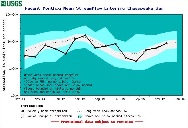
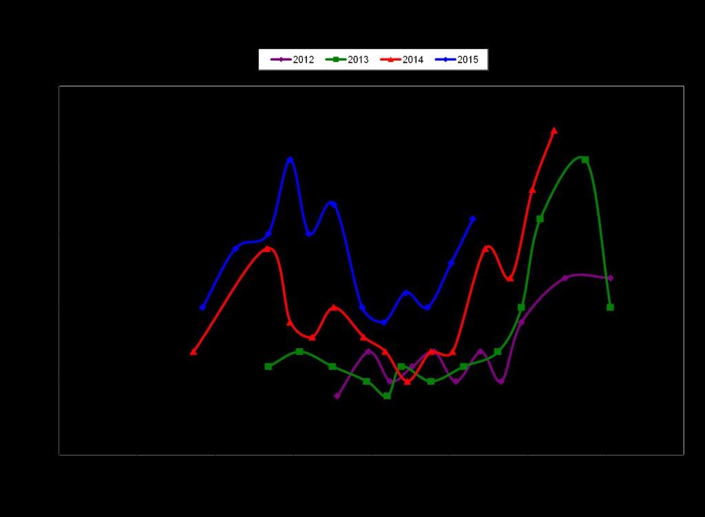
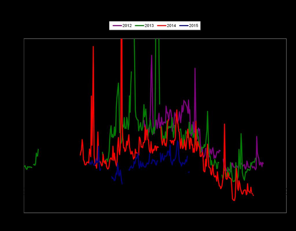
3 Flow Mostly Average or Below Average for 2015

4 Recent Wind Anomalies

5 Reports of Abundant Submerged Aquatic Vegetation in 2015 Numerous inquiries from citizens regarding channel clogging from nuisance SAV Biologists reporting increases in wild celery, hydrilla, widgeon grass Grasses found in some places where they have not been found before MD DNR Biologist, Mark Lewandowski Photo by: Barbara Haddock Taylor, Baltimore Sun A Baltimore Sun 2015 Picture of the Year
6 Stations visited by boat once or twice monthly Water Quality Profiles Sediment, Chl, Nutrients analyzed at laboratories


7 Susq. Bay Bridge PAX MD/VA Rapp. York Mouth

8 Susq. Bay Bridge PAX MD/VA Rapp. York Mouth


9 Susq. Bay Bridge PAX MD/VA Rapp. York Mouth


10 Susq. Bay Bridge PAX MD/VA Rapp. York Mouth

11 Maryland tributary stations (WT/ET) on average 1ppt greater than previous 4 years

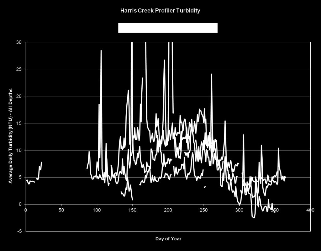
12 Maryland DNR Continuous Monitoring Data and the Choptank River Complex Vertical Profiler, Harris Creek Continuous Monitoring (ConMon) Readings every 15 minutes Dissolved Oxygen, Turbidity, Chl, ph, salinity, water temperature Most sites deployed for 3 years Some sentinel sites exist Vertical Profiler Water column profile every hour Same parameters as ConMon Readings at every half meter Deployed in Harris Creek for past 4 years Maintenance on each is performed every two weeks, and calibration samples are taken at those times.
 (Sept 13-Jan14; Apr14 Dec14; Apr15) Wtemp, salin, cond, chl, turb, ph, depth every 15 minutes Biweekly profiles, nutrients, chl, sediment, & alkalinity Harris Cr.")
 June 26, 2012 - January 22, 2013 April 30, 2013 - December 19, 2013 March 27, 2014 - December 16, 2014 Wtemp, salin, cond, chl, turb,")
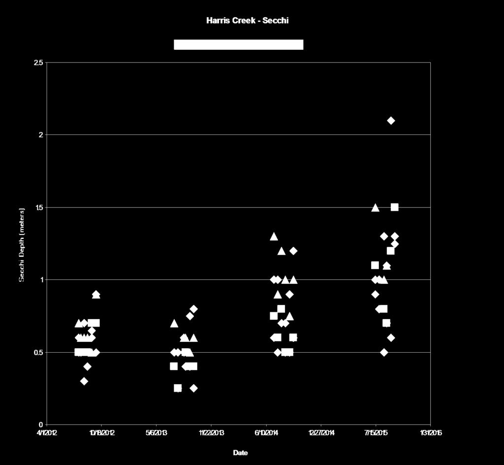
13 Summary of MD DNR Tidal Choptank River Water Quality Data ET5.1 DNR Harris Creek Sites Upstream (0.3m off bottom) (Sept 13-Jan14; Apr14 Dec14; Apr15) Downstream (0.3m off bottom) (Sept 13-Jan14; Apr14 Dec14; Apr15) Wtemp, salin, cond, chl, turb, ph, depth every 15 minutes Biweekly profiles, nutrients, chl, sediment, & alkalinity Harris Cr. Vertical Profiler Mulberry Pt. ConMon Ganey s Wharf ConMon Vertical Profiler (Depths 1,2,3,4,4+) June 26, January 22, 2013 April 30, December 19, 2013 March 27, December 16, 2014 Wtemp, salin, cond, chl, turb, ph, every hour Biweekly profiles, nutrients, chl, sediment, & alkalinity Harris Cr. Up & Downstream Bottom ConMon Dataflow Cruises DNR Long-Term Sites (1985-Present) EE2.1; ET5.2; ET5.1 Monthly WQ profiles; Sediment, Nutrient, Chl samples at surface & depth EE2.1 Jamaica Pt ConMon DNR ConMon Sites (~Apr-Oct ) Ganey s Wharf; Jamaica Pt.; Horn Pt. Mulberry Pt. 1-meter below surface; Wtemp, salin, cond, chl, turb, ph, every 15 minutes Bi-weekly profiles, surface nutrients, chl, sediment DNR Choptank Dataflow (Apr-Oct ) Monthly cruises throughout extent of river and creeks with a four second sample rate of surface waters. 10 calibration sites with profiles, nutrient, sediment, chl samples Horn Pt. ConMon Horn Pt. Hatchery ET5.2 Other Efforts Horn Pt. Hatchery ConMon (wtemp, cond, chl, salin.) Green Eyes Chop River Bridge ConMon (?) NOAA site (Met, Water Level, Wtemp) Gooses Reef (Surface/Bottom WQ; Met)

14
15
16

17 Tred Avon River - Secchi TRAT01 TRAT02 TRAT03 TRAT Secchi Depth (meters) /28/ /10/2006 2/22/2008 7/6/ /18/2010 4/1/2012 8/14/ /27/2014 5/10/2016 Date

18 Broad Creek - Secchi brot01 brot02 brot03 brot Secchi Depth (meters) /1/ /18/2012 5/6/ /22/2013 6/10/ /27/2014 7/15/2015 1/31/2016 Date

19 NOAA Satellite Analysis of Chesapeake Bay Water Clarity
20 Satellite Turbidity Background Specifically designed for accurate measurement in Chesapeake Bay Measurement: Diffuse Light Attenuation Coefficient (m -1 ) Definition: reduction in diffuse light over a distance in the water (at wavelength 490 nm) Geophysical basis: upper water column particles reflect sunlight back to the satellite instrument Depth of measurement: varies with amount of particles in the water, approximate range m, on average 1.0 m Measured by NASA Aqua satellite Instrument: Moderate Resolution Imaging Spectroradiometer (MODIS) Passes over Chesapeake Bay once per day Clouds obscure measurement Weekly or monthly averages more statistically meaningful than daily overpass Algorithm: Wang et al., Journal of Geophysical Research, 2009

21 Satellite Turbidity (Clarity): October high values more turbid, low values more clear October monthly climatology: October monthly average: 2015 October 2015 is clearer than average October of previous 5 years (climatology excludes Oct 2011 due to remaining high sediment from Tropical Storm Lee)
22 Satellite Turbidity (Clarity): November high values more turbid, low values more clear November monthly climatology: November monthly average: 2015 November 2015 is clearer than average November of previous 5 years (climatology excludes Nov 2011 due to remaining high sediment from Tropical Storm Lee)

23 Satellite Time Series Monthly average by year: Oct monthly avg: 2015 is lowest year for main stem, upper bay, & middle bay October Regional averages: Nov monthly avg 2015 is lowest year for upper bay & 2015 are lowest for main stem. November Main Stem = all 3 regions


24 2015 is mostly a low turbidity year Note: 4-year average shows that Bay turbidity is high in winter and summer and low in spring and fall.


25 NOAA Chesapeake Bay Interpretive Buoy System (CBIBS) Range: NTU Wavelength: 700 nm Sensitivity: NTU

26 Annapolis November Turbidity over Time Annapolis Monthly November Turbidity Min Max Median Mean STD
27 Annapolis Statistical Results - Multiple comparison between various years using the one-way analysis of variance (ANOVA) results with 95% confidence levels. - Average daily mean (left) and average daily minimum turbidity (right)
28 Jamestown Statistical Results The Bay was NOT clearer everywhere in Nov than prior years!
29 CBIBS Nov Turbidity Results Increase turbidity Decrease turbidity ( clearer ) Inconclusive results
30
31 Conclusions MD DNR Secchi Disk results revealed that Oct was not clearer than 30 year historical record. However, Oct was clearer when compared to the most recent 5-10 years. NOAA Satellite data showed the majority of the Bay in Oct. and Nov were both clearer than the average of the previous 5 years of each month, respectively. NOAA CBIBS Nov turbidity was statistically lower than the majority of prior Novembers at 5 of the 10 buoys. The entire Bay was not clearer in Oct. and Nov Two buoys had statistically higher turbidity in Nov and the satellite data also showed areas of increased turbidity in Oct. and Nov DNR and CBIBS data showed the correlation between turbidity and salinity. In the majority of the buoys, the turbidity lowered with increased salinity, as expected. Further research could be done linking the USGS flow gage data, wind anomalies, salinity, turbidity and chlorophyll to get a better understanding of the causes of the Nov. and Oct water quality results.
Chesapeake Bay. report card
 Chesapeake Bay report card 2010 C- C Healthy water quality provides better habitat conditions for crabs, fish, and other aquatic species. issolved oxygen is essential to the survival of all these organisms;
Modeling Quarterly Review Meeting January 14, Bruce Michael Maryland Department of Natural Resources
 Ongoing Conowingo Dam / Lower Susquehanna River Studies Modeling Quarterly Review Meeting January 14, 2015 Bruce Michael Maryland Department of Natural Resources Draft Lower Susquehanna River Watershed
Annual Update. Large-Scale Oyster Restoration in Support of the Chesapeake Bay Agreement Oyster Goal. Stephanie Reynolds Westby, NOAA
 Annual Update Large-Scale Oyster Restoration in Support of the Chesapeake Bay Agreement Oyster Goal Stephanie Reynolds Westby, NOAA Susan Conner, USACE- Norfolk District Policy Drivers Executive Order
How global warming and climate change may be accelerating losses of Chesapeake Bay seagrasses.
 How global warming and climate change may be accelerating losses of Chesapeake Bay seagrasses. Dr. Ken Moore The Virginia Institute of Marine Science School of Marine Science College of William and Mary
Dead-Zones and Coastal Eutrophication: Case- Study of Chesapeake Bay W. M. Kemp University of Maryland CES Horn Point Laboratory Cambridge, MD
 Dead-Zones and Coastal Eutrophication: Case- Study of Chesapeake Bay W. M. Kemp University of Maryland CES Horn Point Laboratory Cambridge, MD Presentation to COSEE Trends Orientation at UMCES HPL 4 August
Lake Pepin Photo by Guy Schmickle
 Science Advisory Panel Meeting Lake Pepin Water Quality Modeling Project April 30, 2008 Lake Pepin Photo by Guy Schmickle Overview Modeling status Historical system behavior Model simulation scenarios
Modeling Eutrophication Processes in the Delaware Estuary to Link Watershed Efforts to Control Nutrient Impacts
 Modeling Eutrophication Processes in the Delaware Estuary to Link Watershed Efforts to Control Nutrient Impacts Delaware Watershed Research Conference Philadelphia, PA November 8, 2017 Principal Investigators:
What s Happening in Lake Whatcom?
 What s Happening in Lake Whatcom? Dr. Robin A. Matthews, Director Institute for Watershed Studies Huxley College of the Environment Western Washington University June 6, 2011 Site 2 Basin 2 Lake Whatcom
Lake Pepin Photo by Guy Schmickle
 Options for Meeting Water Quality Standards Lake Pepin Technical Conference September 23, 28 Lake Pepin Photo by Guy Schmickle Overview Role of modeling in the TMDL Main features of UMR-LP Model Reductions
Observing the Ocean. A series of activities that demonstrate how scientists study the ocean through modern technology
 Observing the Ocean A series of activities that demonstrate how scientists study the ocean through modern technology Objective Students investigate the many uses of ocean observing systems and how the
Phosphorus Loading and Related Impacts in Southern Cayuga Lake. Dave Matthews Upstate Freshwater Institute Syracuse, NY
 Phosphorus Loading and Related Impacts in Southern Cayuga Lake Dave Matthews Upstate Freshwater Institute Syracuse, NY Upstate Freshwater Institute (UFI) mission: advance freshwater research and protect
Details of DO Criteria. Peter Tango EPA Chesapeake Bay Program Office March 16, 2011
 Details of DO Criteria Peter Tango USGS@ EPA Chesapeake Bay Program Office March 16, 2011 Umbrella Criteria Action Team Walter Boynton Jeni Keisman Tish Robertson Elgin Perry Claire Buchanan Matt Hall
Assessment of Six Chesapeake Bay Rivers
 Assessment of Six Chesapeake Bay Rivers Dominant Land Use Type Years Studied 2007-2011 2010-2012 Agricultural Corsica Sassafras Developed Magothy Middle Forested Rhode Nanjemoy Goal: Provide insights on
CONTENTS: EXAMPLE: THE CHESAPEAKE BAY INTERPRETIVE BUOY SYSTEM (CBIBS) SUSTAINABILITY AND THE IMPORTANCE NUTRIENT AND OTHER MONITORING IN CBIBS
 SUSTAINABILITY AND THE IMPORTANCE NUTRIENT AND OTHER MONITORING IN CBIBS") CONTENTS: EXAMPLE: THE CHESAPEAKE BAY INTERPRETIVE BUOY SYSTEM (CBIBS) SUSTAINABILITY AND THE IMPORTANCE OF REAL-TIME OBSERVATIONS NUTRIENT AND OTHER MONITORING IN CBIBS NEW PROJECTS LESSONS LEARNED CBIBS
CONTENTS: EXAMPLE: THE CHESAPEAKE BAY INTERPRETIVE BUOY SYSTEM (CBIBS) SUSTAINABILITY AND THE IMPORTANCE OF REAL-TIME OBSERVATIONS NUTRIENT AND OTHER MONITORING IN CBIBS NEW PROJECTS LESSONS LEARNED CBIBS
St. Lucie Estuary: Analysis of Annual Cycles and Integrated Water Column Productivity
 St. Lucie Estuary: Analysis of Annual Cycles and Integrated Water Column Productivity Tom Gallo, Malcolm Pirnie Inc. Clifton Bell, Malcolm Pirnie Inc. Peter Doering, South Florida Water Management District
Watershed - Lake Model to Support TMDL Determinations for Lake Thunderbird
 Watershed - Lake Model to Support TMDL Determinations for Lake Thunderbird 18 th Annual EPA Region 6 Stormwater Conference Workshop 5: TMDLs and You October 3, 2016 Oklahoma City, OK Lake Thunderbird Watershed-Lake
Flow-ecology relationships. Flow-ecology relationships Susitna case study
 Flow-ecology relationships Flow-ecology relationships Susitna case study Flow regime Ecologically-Relevant Flow Regime Characteristics Seasonal or typical conditions Annual extreme conditions High and
Watershed and Water Quality Modeling to Support TMDL Determinations Lake Oologah
 Watershed and Water Quality Modeling to Support TMDL Determinations Lake Oologah 26 th Annual Conference Oklahoma Clean Lakes and Watersheds Association (OCLWA) April 5-6, 2017 Stillwater, Oklahoma Lake
Mona Lake Modeling: Model Parameters and Sampling Strategy
 Mona Lake Modeling: Model Parameters and Sampling Strategy About Watershed: 200 km 2 Mona Lake: 2.65 km 2 - Black Creek: 0.482-2.69 m 3 /s Little Black Creek: 0.040-0.442 m 3 /s Cress Creek: 0.050-0.163
Climate Change, Marsh Erosion and the Chesapeake Bay TMDL
 Climate Change, Marsh Erosion and the Chesapeake Bay TMDL Rising sea level in Chesapeake Bay is inexorable. One environmental effect associated with sea level rise is marsh erosion. Marsh erosion can impact
IMPROVEMENTS IN WATER QUALITY OF A DANISH ESTUARY FOLLOWING NUTRIENT REDUCTIONS
 IMPROVEMENTS IN WATER QUALITY OF A DANISH ESTUARY FOLLOWING NUTRIENT REDUCTIONS Peter Stæhr 1, Jeremy Testa 2, Jacob Carstensen 1 1 Dept. Bioscience,, Denmark 2 Chesapeake Biological Laboratory, Univ.
Portage Lake Hubbard County
 Prepared in cooperation with the Minnesota Department of Natural Resources Minnesota Lake ID: 9- Area: acres Watershed Area: 6,7 acres Ecoregion: Northern Lakes and Forests (NLF) Portage Lake Hubbard County
Pennsylvania Pequea and Mill Creek Watershed Section 319 National Monitoring Program Project
 Pennsylvania Pequea and Mill Creek Watershed Section 319 National Monitoring Program Project Figure 36: Pequea and Mill Creek (Pennsylvania) Watershed Project Location 231 T-1 C-1 T1-3 T-4 C1-2 T2-3 T-2
Fall Line Input Monitoring on the Potomac River at Chain Bridge
 Fall Line Input Monitoring on the Potomac River at Chain Bridge 1983-2007 Metropolitan Washington Council of Governments and Occoquan Watershed Monitoring Laboratory Regional Monitoring Subcommittee Meeting
Long-Term Volunteer Lake Monitoring in the Upper Woonasquatucket Watershed
 Long-Term Volunteer Lake Monitoring in the Upper Woonasquatucket Watershed Linda Green URI Watershed Watch 1-87-95, lgreen@uri.edu WATER QUALITY IS A REFLECTION OF THE ACTIVITIES IN THE LANDS AND WATERS
Measuring Ocean Color: The Basics
 Measuring Ocean Color: The Basics Radiation of energy from the Sun and the Earth s surface. Recall from previous lectures that the Sun (6000 K), radiates energy in three portions of the energy spectrum:
Crystal Lake and Keller Lake Water Quality Evaluation and Ferric Chloride Treatment Project
 Crystal Lake and Keller Lake Water Quality Evaluation and Ferric Chloride Treatment Project Assessment for 8 Prepared for Black Dog Watershed Management Organization January 9 Crystal Lake and Keller Lake
James River Alternatives Analysis June 23, 2005
 James River Alternatives Analysis June 23, 2005 Prepared by: Virginia Department of Environmental Quality in cooperation with the U.S. EPA Chesapeake Bay Program Office [ THIS PAGE INTENTIONALLY LEFT BLANK
MARYLAND DEPARTMENT OF THE ENVIRONMENT 1800 Washington Boulevard Baltimore MD
 MARYLAND DEPARTMENT OF THE ENVIRONMENT 1800 Washington Boulevard Baltimore MD 21230 410-537-3000 1-800-633-6101 Martin O Malley Governor Anthony G. Brown Lieutenant Governor November 6, 2009 Shari T. Wilson
The Myakka River. Presented to the Myakka River Management Coordinating Council January 9, 2009
 The Myakka River Presented to the Myakka River Management Coordinating Council January 9, 2009 Kathryn L. Meaux Environmental Specialist III Sarasota County Integrated Water Resources Historical Monitoring
Chapter Seven: Factors Affecting the Impact of Nutrient Enrichment on the Lower Estuary
 Chapter Seven: Factors Affecting the Impact of Nutrient Enrichment on the Lower Estuary As presented in Chapter Six, the water quality data for the upper stations of the tidal freshwater Potomac Estuary
Content Overview of the next Chesapeake Bay Ambient Water Quality Criteria Technical Addendum
 Content Overview of the next Chesapeake Bay Ambient Water Quality Criteria Technical Addendum Peter Tango USGS@CBPO February 12, 2016 STAC Criteria Addendum Review Panel The Water Quality Standards Framework
Water Quality Study In the Streams of Flint Creek and Flint River Watersheds For TMDL Development
 Water Quality Study In the Streams of Flint Creek and Flint River Watersheds For TMDL Development Idris Abdi Doctoral Dissertation Presentation Major Advisor: Dr. Teferi Tsegaye April 18, 2005 Alabama
URI Watershed Watch: 25 Years of Documenting RI s Waters
 URI Watershed Watch: 25 Years of Documenting RI s Waters Elizabeth Herron Linda Green Arthur Gold University of Rhode Island - Natural Resources Science URI Cooperative Extension Annual Monitoring Data
Continuous, Real-time Nutrient Data and Regression Models Valuable Information for Monitoring Aquatic Ecosystem Restoration
 Continuous, Real-time Nutrient Data and Regression Models Valuable Information for Monitoring Aquatic Ecosystem Restoration Teresa Rasmussen, Jennifer Graham, Mandy Stone, US Geological Survey, Kansas
Grants Pass Water Quality Monitoring
 Grants Pass Water Quality Monitoring 2003-2005 Rogue Valley Council of Governments April 2005 Rogue Valley Council of Governments Natural Resources Department 155 North First Street Central Point, Oregon
SECTION 2 WATER 2.1 ROUTINE WATER COLUMN MONITORING Collection Summary
 SECTION 2 WATER 2.1 ROUTINE WATER COLUMN MONITORING 2.1.1 Collection Summary Routine water column sampling was performed biweekly between May and October for a total of 13 sampling rounds. Water column
2009/2010 Water Column Overview, Red Tide Update, and Bay Eutrophication Model 2010 Results. OMSAP Meeting June 30, 2011.
 29/21 Water Column Overview, Red Tide Update, and Bay Eutrophication Model 21 Results OMSAP Meeting June 3, 211 Scott Libby Contributions from D. Anderson, D. Borkman, C.S. Chen, R. Geyer, and C. Oviatt
Rock Creek Floodplain Analysis
 Rock Creek Floodplain Analysis www.co.washington.or.us By Jon Franczyk 1996 Flood, www.co.washington.or.us 1996 Flood, www.co.washington.or.us Project Outline Project Goals Introduction Background Study
Watershed, Hydrodynamic, Water Quality and Sediment Flux Modeling to Support TMDL Determinations, Lake Thunderbird
 Watershed, Hydrodynamic, Water Quality and Sediment Flux Modeling to Support TMDL Determinations, Lake Thunderbird 24 th Annual Conference Oklahoma Clean Lakes and Watersheds Association (OCLWA) April
Sustainable Fisheries GIT: Fish Habitat
 Quarterly Progress Meeting - May 2017 Chesapeake Bay Program Science. Restoration Partnership. Sustainable Fisheries GIT: Fish Habitat Bruce Vogt, NOAA and Sustainable Fisheries GIT Coordinator Gina Hunt,
Qian Zhang (UMCES / CBPO) Joel Blomquist (USGS / ITAT)
 Joel Blomquist (USGS / ITAT)") CBP STAC Water Clarity Workshop Solomons, MD, 02/06/2017 Long-term Riverine Inputs from Major Tributaries to Chesapeake Bay Relevant to Water Clarity Qian Zhang (UMCES / CBPO) Joel Blomquist (USGS / ITAT)
CBP STAC Water Clarity Workshop Solomons, MD, 02/06/2017 Long-term Riverine Inputs from Major Tributaries to Chesapeake Bay Relevant to Water Clarity Qian Zhang (UMCES / CBPO) Joel Blomquist (USGS / ITAT)
Aquatic Ecosystems of the Pittsburgh District
 Aquatic Ecosystems of the Pittsburgh District Carl Nim M.A. MEn. Biologist U.S. Army Corps of Engineers Pittsburgh District 4 May 2016 US Army Corps of Engineers Outline District Overview Water Quality
2014 Data Report for Higgins Lake, Roscommon County North Basin
 214 Data Report for Higgins Lake, Roscommon County North Basin Michigan Lakes Ours to Protect The CLMP is brought to you by: About this report: This report is a summary of the data that have been collected
2012 Nutrient Regulations Update
 2012 Nutrient Regulations Update OWEA Government Affairs Workshop March 1, 2012 Guy Jamesson, PE, BCEE Malcolm Pirnie, The Water Division of ARCADIS Imagine the result Agenda Nutrient impacts Nutrient
Appendix 5. Fox River Study Group Interim Monitoring Evaluation
 Appendix 5. Fox River Study Group Interim Monitoring Evaluation Introduction Submitted to Fox River Study Group 6 March 3 The purpose of this report is to review data collected by the Fox River Study Group
NOAA Chesapeake Bay Office Biennial Report to Congress Fiscal Years
 NOAA Chesapeake Bay Office Biennial Report to Congress Fiscal Years 2013 2014 A Few Highlights from the Biennium (2013 2014) 198. Acres of oyster reef in Virginia and Maryland tributaries restored by NOAA
Relationship Between Bacteria and Conventional Water Quality Parameters
 Relationship Between Bacteria and Conventional Water Quality Parameters Hanadi S. Rifai, Ph. D., P. E., F. ASCE Professor and Director Environmental Engineering Graduate Program Civil and Environmental
Mercury in the Biostrome Community of the Great Salt Lake
 Utah State University DigitalCommons@USU Watershed Sciences Faculty Publications Watershed Sciences 2009 Mercury in the Biostrome Community of the Great Salt Lake Wayne A. Wurtsbaugh Utah State University
Modeling Chester River Water Quality...
 Modeling Chester River Water Quality... Jeremy Testa Damian Brady Kelly Cole Ming Li University of Maryland Center for Environmental Science University of Maine Outline (1) Quick update on ROMS (2) Comparison
Water Quality Monitoring Report. Tom Ash Assistant Director Water Management Division October 16, 2014
 Water Quality Monitoring Report Tom Ash Assistant Director Water Management Division October 16, 2014 basic to any approach toward protections of the aquatic environment in the Tampa Bay area would be
DEALING WITH STRATIFICATION WITHIN A WATER SUPPLY RESERVOIR. Chris Perks. Central Highlands Water
 DEALING WITH STRATIFICATION WITHIN A WATER SUPPLY RESERVOIR Paper Presented by : Chris Perks Author: Chris Perks, Water Resources Operator Central Highlands Water 69 th Annual Water Industry Engineers
Leesville Lake Water Quality Monitoring
 Leesville Lake Water Quality Monitoring Prepared for: Leesville Lake Association Prepared by: Dr. Thomas Shahady Lynchburg College Funds Supplied by: American Electric Power & Leesville Lake Association
Decision Rationale. Total Maximum Daily Load for Phosphorus for the Sassafras River, Cecil and Kent Counties, Maryland 4/1/2002
 Decision Rationale I. Introduction Total Maximum Daily Load for Phosphorus for the Sassafras River, Cecil and Kent Counties, Maryland 4/1/2002 The Clean Water Act (CWA) requires a Total Maximum Daily Load
Real time Water Quality Monitoring
 Real time Water Quality Monitoring Robert Schuster New Jersey Department of Environmental Protection Water Monitoring and Standards Bureau of Marine Water Monitoring Presented at NJWMCC Meeting September
Data Required to Support Reservoir Water Quality Modeling
 Data Required to Support Reservoir ater Quality Modeling The recommendations contained within this document are intended to assist with developing field data collection programs that can support reservoir
fcgov.com/water-quality Water Quality Update Summer 2017 Monitoring and Protecting Our Water Sources
 Water Quality Update Summer 217 Monitoring and Protecting Our Water Sources SOURCE WATER MONITORING The Upper Cache la Poudre (UCLP) Watershed Collaborative Monitoring Program was established in 28 between
Estimation of chlorophyll-a concentration in estuarine waters:
 Estimation of chlorophyll-a concentration in estuarine waters: case study of the Pearl River estuary Yuanzhi Zhang *, Chuqun Chen #, Hongsheng Zhang *, Xiaofei*, Chen Guiying Chen# *Institute of Space
Potato Lake 2010 Project Results and APM Plan. Saturday May 28, 2011 Dave Blumer, Jake Macholl SEH Lake Scientists
 Potato Lake 2010 Project Results and APM Plan Saturday May 28, 2011 Dave Blumer, Jake Macholl SEH Lake Scientists Lake and Aquatic Plant Management Planning Goal: To maintain or improve the overall condition
National Integrated Drought Information System Southeast US Pilot for Apalachicola- Chattahooche-Flint River Basin. 14 August 2012
 National Integrated Drought Information System Southeast US Pilot for Apalachicola- Chattahooche-Flint River Basin 14 August 2012 Outline Welcome Keith Ingram, UF, Southeast Climate Consortium Current
The State of Everglades Restoration
 FCE-LTER All Scientist Meeting The State of Everglades Restoration Fred H. Sklar 14 March 2016 Deering Estate Restoration Update Outline 1. Reservoirs, STAs & FEBs 2. Broward WPA s 3. DPM 4. MFL & Seagrass
Otter Creek Watershed TMDL Project. Stakeholder Meeting June 6, 2013
 Otter Creek Watershed TMDL Project Stakeholder Meeting June 6, 2013 1 Meeting Purpose Meet with watershed & technical advisory group members and watershed landowners to provide basic Otter Creek TMDL project
Boston Harbor Water Quality ( ) Massachusetts Water Resources Authority Environmental Quality Department Report
 Massachusetts Water Resources Authority Environmental Quality Department Report") Boston Harbor Water Quality (1994-2015) Massachusetts Water Resources Authority Environmental Quality Department Report 2016-08 Citation: Taylor, DI. 2016. Boston Harbor Water Quality (1994-2015). Boston:
Boston Harbor Water Quality (1994-2015) Massachusetts Water Resources Authority Environmental Quality Department Report 2016-08 Citation: Taylor, DI. 2016. Boston Harbor Water Quality (1994-2015). Boston:
Water Quality in Stormwater Ponds
 Water Quality in Stormwater Ponds Linking Nutrients, Algae and Dissolved Oxygen Erik M. Smith University of South Carolina, Baruch Marine Field Laboratory North Inlet - Winyah Bay National Estuarine Research
What is Hydrologic Optics? Optics Attentuation Inherent properties Scatter Absorption Apparent properties
 1 of 7 3/22/2006 1:29 PM Water quality research Water quality Hydrologic optics Components of water quality SERC water research projects CISNet program What is Hydrologic Optics? Optics Attentuation Inherent
Outer Cove Brook Network
 Real Time Water Quality Report Outer Cove Brook Network Deployment Period August 6 to September 4, 2013 Government of Newfoundland & Labrador Department of Environment and Conservation Water Resources
Science For Coastal Wetland Restoration
 Science For Coastal Wetland Restoration Dr. Alfred F. Cofrancesco Technical Director Engineer Research and Development Center; Vicksburg, MS 24 May 2010 US Army Corps of Engineers Coastal Wetlands Restoration
Interpreting Lake Data
 Interpreting Lake Data Indiana Clean Lakes Program The Indiana Clean Lakes Program was created in 1989 as a program within the Indiana Department of Environmental Management's (IDEM) Office of Water Management.
Session 2 Biodiversity Conservation
 Session 2 Biodiversity Conservation Nutrient Concentration and Water Turbidity on Coral Reef Area and their Effects on the Living Coral Koichi KINJO Okinawa Prefectural Institute of Health and Environment
Cleveland Bay Marine Water Quality (Turbidity and Available Light) Monitoring Plan
 Monitoring Plan") Cleveland Bay Marine Water Quality (Turbidity and Available Light) Monitoring Plan 1 BACKGROUND Port of Townsville Limited (PoTL) administers the Port of Townsville, a general purpose cargo port in North
Cleveland Bay Marine Water Quality (Turbidity and Available Light) Monitoring Plan 1 BACKGROUND Port of Townsville Limited (PoTL) administers the Port of Townsville, a general purpose cargo port in North
Chetco Estuary and Boat Basin Water Quality Monitoring
 Chetco Estuary and Boat Basin Water Quality Monitoring Executive Summary The South Coast Watershed Council monitored the Chetco Estuary and Boat Basin to determine oxygen conditions in the basins, effectiveness
Instructions to Regional Planners
 Module 1 Educator s Guide, Handout 3: Regional Planner Instructions Investigation 1 Instructions to Regional Planners You are a planner on the Chesapeake Bay regional planning council. Prior to the town
What is Run-of-river hydro?
 The Project: The Corporation of the Village of Slocan submitted a waterpower project application on Springer Creek in May 2010 Engineering & Environmental studies were performed on the project site to
Lake Pepin TMDL Water Quality Objectives
 some preliminary thoughts on how Upper Mississippi River Environmental Pool Plan Restoration Features and Activities may relate to Lake Pepin TMDL Water Quality Objectives TMDL = WLA + LA + MOS + RC Scot
Warm Mineral Springs Sampling by Sarasota County
 Warm Mineral Springs Sampling by Sarasota County John Ryan, Kathryn Meaux, Rene Janneman and Jon S. Perry Sarasota County Environmental Services Sarasota, Florida September 11 Warm Mineral Springs is a
Salinity TMDL Development and Modeling in the Otter Creek Watershed. Erik Makus DEQ Hydrologist June 6, 2013
 Salinity TMDL Development and Modeling in the Otter Creek Watershed 1 Erik Makus DEQ Hydrologist June 6, 2013 Outline for Today: Otter Creek and the Tongue River Previous salinity modeling efforts Existing
TWENTY-ONE-YEAR SIMULATION OF CHESAPEAKE BAY WATER QUALITY USING THE CE-QUAL-ICM EUTROPHICATION MODEL 1
 AMERICAN WATER RESOURCES ASSOCIATION TWENTY-ONE-YEAR SIMULATION OF CHESAPEAKE BAY WATER QUALITY USING THE CE-QUAL-ICM EUTROPHICATION MODEL 1 Carl F. Cerco and Mark R. Noel 2 ABSTRACT: The CE-QUAL-ICM (Corps
Zu-Tao Ou-Yang Center for Global Change and Earth Observation Michigan State University
 Zu-Tao Ou-Yang Center for Global Change and Earth Observation Michigan State University Ocean Color: Spectral Visible Radiometry Color of the ocean contains latent information on the water qualitycdom,
25 years of Hawaii Ocean Time-series carbon flux determinations: Insights into productivity, export, and nutrient supply in the oligotrophic ocean
 25 years of Hawaii Ocean Time-series carbon flux determinations: Insights into productivity, export, and nutrient supply in the oligotrophic ocean MATTHEW CHURCH, ROBERT BIDIGARE, JOHN DORE, DAVID KARL,
clarity terc.ucdavis.edu 11
 clarity 11 Annual average Secchi depth Yearly since 1968 The Secchi depth is the depth at which a 10-inch white disk, called a Secchi disk, remains visible when lowered into the water. In 2015, the annual
Light and the Aquatic Ecosystem
 Light and the Aquatic Ecosystem Why is light important? Ultimate source of energy in all carbon containing materials entering the water. Sunlight drives the entire aquatic ecosystem. What Do Limnologists
Elsinore Valley Municipal Water District. Lake Elsinore Phase 2 Water Quality Monitoring Plan
 Elsinore Valley Municipal Water District Lake Elsinore Phase 2 Water Quality Monitoring Plan to Evaluate the Efficacy of the In-Lake Nutrient Reduction Facilities (Aeration and Mixing) for Lake Elsinore
Yahara WINS Group Meeting. September 13, 2017
 Yahara WINS Group Meeting September 13, 2017 Approval of Minutes Review and acceptance of 06/13/2017 meeting summary Updates Consulting Director contract signed Yahara Pride LDMI project moving forward
CHESAPEAKE BAY PROGRAM BAY BAROMETER HEALTH & RESTORATION IN THE CHESAPEAKE BAY WATERSHED
 CHESAPEAKE BAY PROGRAM 216-217 BAY BAROMETER HEALTH & RESTORATION IN THE CHESAPEAKE BAY WATERSHED BAY BAROMETER The Chesapeake Bay watershed is a dynamic ecosystem. Tracking changes in its health over
Lake Pepin. TMDL Basics
 NORTH DAKOTA SOUTH DAKOTA Lake Pepin Basins BASIN Cannon River Basin Minnesota River Basin Minnesota River Basin St. Croix River Basin Upper Mississippi River Basin HUC 07040001 Major Rivers Metro Area
MARYLAND CHESAPEAKE BAY WATER QUALITY MONITORING PROGRAM ECOSYTEMS PROCESSES COMPONENT (EPC)
") Technical Report Series No. TS-447-04-CBL Ref. No. [UMCES]CBL 04-086 University of Maryland Center for Environmental Science Maryland Department of Natural Resources MARYLAND CHESAPEAKE BAY WATER QUALITY
Technical Report Series No. TS-447-04-CBL Ref. No. [UMCES]CBL 04-086 University of Maryland Center for Environmental Science Maryland Department of Natural Resources MARYLAND CHESAPEAKE BAY WATER QUALITY
Water Quality Assessment for the Tongue River Watershed, Montana
 Water Quality Assessment for the Tongue River Watershed, Montana August 2, 2007 FINAL DRAFT Prepared by: U.S. Environmental Protection Agency Montana Operations Office and Tetra Tech, Inc. Project Manager:
Integrating Water Quality and Natural Filters into Maryland s Marine Spatial Planning Efforts
 Integrating Water Quality and Natural Filters into Maryland s Marine Spatial Planning Efforts Nicole Carlozo NOAA Coastal Management Fellow July 31, 2014 Watershed-scale restoration targeting helps direct
Tracking the Turbidity Maximum Zone in the Gironde estuary (SW France) based on continuous monitoring and radionuclides
 based on continuous monitoring and radionuclides") Tracking the Turbidity Maximum Zone in the Gironde estuary (SW France) based on continuous monitoring and radionuclides Sabine Schmidt, A. Sottolichio, H. Derriennic, G. Chabaud, P. Lebleu, H.-K. Saari,
Tracking the Turbidity Maximum Zone in the Gironde estuary (SW France) based on continuous monitoring and radionuclides Sabine Schmidt, A. Sottolichio, H. Derriennic, G. Chabaud, P. Lebleu, H.-K. Saari,
Gull Lake CASS & CROW WING COUNTIES
 Gull Lake 11-0305-00 CASS & CROW WING COUNTIES Summary Gull Lake is located just northwest of Brainerd, Minnesota, on the border of Cass and Crow Wing Counties. It covers 9,947 acres, which places it in
Welcome. Thank you for joining us! Lower Mississippi River Watershed Management Organization
 Welcome. Thank you for joining us! Lower Mississippi River Watershed Management Organization Lower Mississippi River Watershed Management Organization Watershed Restoration and Protection (WRAP) Study
Application of Gliders for Near-Real Time METOC Data Collection Capability for Battlespace Characterization
 DISTRIBUTION STATEMENT A: Approved for public release; distribution is unlimited. Application of Gliders for Near-Real Time METOC Data Collection Capability for Battlespace Characterization Charles Trees
Delaware s Inland Bays Seagrass Reestablishment Project & SAV as an Environmental Indicator
 Delaware s Inland Bays Seagrass Reestablishment Project & SAV as an Environmental Indicator Inland Bays SAV History of SAV in the Inland Bays Introduction to SAV Restoration/Project History Results to
How safe is Beijing s Air Quality for Human Health? Naresh Kumar Θ
 How safe is Beijing s Air Quality for Human Health? Naresh Kumar Θ Abstract: The success of the 2008 Olympics will be largely impacted by the level of air pollution in Beijing. The World Health Organization
Selecting indicators based on river science two examples
 Selecting indicators based on river science two examples use High turbidity, poor vegetation Increase vegetation using summer water level drawdowns to expose sediment and germinate plants Sediments dry
BIOMES. Living World
 BIOMES Living World Biomes Biomes are large regions of the world with distinctive climate, wildlife and vegetation. They are divided by terrestrial (land) or aquatic biomes. Terrestrial Biomes Terrestrial
Field Survey and Satellite Validation of Water Quality Parameters of Rivers in the Surroundings of Santo Domingo Metropolitan Area, Dominican Republic
 EMECS 9 (Baltimore, 27 31 August 2011) Field Survey and Satellite Validation of Water Quality Parameters of Rivers in the Surroundings of Santo Domingo Metropolitan Area, Dominican Republic Hiroshima University
Ponds: Careful of the Fish!
 Ponds: Careful of the Fish! Dr. Chuck Cichra Extension Fisheries Specialist University of Florida / IFAS SFRC - Program of Fisheries & Aquatic Sciences All Plants Need Water, Light, and Nutrients Aquatic
Water Turbidity as One of the Trophic State Indices in Butrinti Lake
 Journal of Water Resource and Protection, 2013, 5, 1144-1148 Published Online December 2013 (http://www.scirp.org/journal/jwarp) http://dx.doi.org/10.4236/jwarp.2013.512120 Water Turbidity as One of the
Development of Chlorophyll-a Criteria to Support Recreational Uses of Texas Reservoirs
 Development of Chlorophyll-a Criteria to Support Recreational Uses of Texas Reservoirs Exploratory Data Analysis - Year 1 of a 2-Year Study William W. Walker, Jr., Ph.D. Environmental Engineer wwwalker.net