G l o b a l L a n d S e r v i c e
|
|
|
- Katherine Hunter
- 5 years ago
- Views:
Transcription


1 G l o b a l L a n d S e r v i c e Mark Dowell European Commission JRC mark.dowell@ec.europa.eu
2 2 M a n d a t e o f C o p e r n i c u s L a n d M o n i t o r i n g S e r v i c e the land monitoring service, which is to provide information on land use and land cover, cryosphere, climate change and biogeophysical variables, including their dynamics, in support of the global-to-local environmental monitoring of biodiversity, soil, inland and coastal waters, forests and vegetation, and natural resources,


3 Operational Copernicus Service Long term and reliable provision of products and services for downstream applications Delivery of fully validated and quality controlled products and services Support to EU policies at international level & EU commitments under treaties & conventions fuel Europe s contribution to GEOSS Wide range of applications: water management, desertification, natural resources management, food security, biodiversity, forestry, agriculture, cover & use change, 3
4 4 G L O B A L L A N D C o m p o n e n t : 1. Global Operations: 2. In-Situ Ground Observations (GBOV) 3. Hot-Spot 4. Sentinel-2 global mosaic (Application Ready Data)
 Burnt Area ENERGY Top-of-Canopy reflectance Surface Albedo Surface Temperature WATER Water Bodies Soil")
5 Portfolio GIO VEGETATION Leaf Area Index Fraction of Absorbed Photosynthetically Active Radiation (FAPAR) Fraction of vegetation cover (FCOVER) Normalized Difference Vegetation Index (NDVI) Vegetation Condition Index Vegetation Productivity Index Dry Matter Productivity (~ biomass) Burnt Area ENERGY Top-of-Canopy reflectance Surface Albedo Surface Temperature WATER Water Bodies Soil Water Index 5
 Burnt Area Greenness Evolution Index ENERGY Top-of-Canopy reflectance Surface Albedo Surface Temperature")
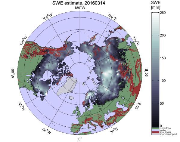
6 Portfolio VEGETATION Leaf Area Index Fraction of Absorbed Photosynthetically Active Radiation (FAPAR) Fraction of vegetation cover (FCOVER) Normalized Difference Vegetation Index (NDVI) Vegetation Condition Index Vegetation Productivity Index Dry Matter Productivity (~ biomass) Burnt Area Greenness Evolution Index ENERGY Top-of-Canopy reflectance Surface Albedo Surface Temperature Radiation Fluxes Evapotranspiration Active Fires Surface soil moisture Soil Water Index Moderate Yearly Cover WATER Water Bodies Coastal Erosion Lake surface water temperature Lake and river water level Lake surface reflectance Lake turbidity Lake trophic state Lake ice coverage CRYOSPHERE Snow extent Snow water equivalent Lake Ice Extent 6


7 GLOBAL LAND portfolio Energy and Water
 Tutorials, webinars, software integrations")
8 A c c e s s & s u p p o r t s e r v i c e s Website & mailing Map and Time Series viewing services Product distribution (web & EUMETCast) Tutorials, webinars, software integrations Helpdesk


9 E x a m p l e f u l l - r e s o l u t i o n m a p v i e w e r NDVI v2 June 16 LAI v1 Sept 16

10 E x a m p l e t i m e s e r i e s v i e w e r

. Larger Than Elephants - Inputs for an EU strategic approach to wildlife conservation in Africa.")
11 GLOBAL LAND Hot Spot component Provide detailed land cover information on specific areas of i n t e r e s t f o r EU o u t s i d e the European Union, particularly in the d o m a i n of t h e s u s t a i n a b l e management of natural resources. Africa : Areas of interest defined in collaboration with DG DEVCO to support EU Biodiversity Strategy in Africa. Pironio, E. & Mayaux, P. ed. (2015). Larger Than Elephants - Inputs for an EU strategic approach to wildlife conservation in Africa. Asia : EU funded project in collaboration with GIZ and Portuguese Coop. in Timor- Leste.
12 HSM GL T h e m a t i c a n d s p a t i a l R e s o l u t i o n u p a n d d o w n s c a l i n g - c o m p a t i b i l i t y w i t h p l a n n e d G L y e a r l y g l o b a l l a n d c o v e r p r o d u c t SPOT VGT 1km MODIS 250m PROBA-V 1km 333m GLOBAL-V Sentinel 3 300m sat series 30m Sentinel m Product cube
13 RC1


14 RC1 ZOOM UGANDA
 Derives Start of Wet Season")

")

15 G l o b a l - S p o t l i g h t o n u s e r s CSE (Senegal) & CREAF (Spain) Uses FAPAR for biomass estimation for agricultural areas GeoVille GmbH (Austria) Derives Start of Wet Season (SoS, left) indicators from CGLS Soil Water Index ACF NGO (Spain / West Africa) Water accessibility index map produced with Hydrogenerator for Environment and Security in Africa (African Union) Pre-cursor to GMES&Africa Use CGLS products in continental, multilateral and national agro-meteo & environmental bulletins End of 2016, Copernicus Global Service (CGLS) reached web portal visitors 1500 users of the data online 600 through satellite broadcast and the numbers are growing. The second operations phase ( ) was started and looks ahead to an extended product portfolio.
 Hydroweb portal for")


16 G l o b a l - S p o t l i g h t o n u s e r s : C o m i n g s o o n CNES / Theia Data Centre (France) Hydroweb portal for displaying water level time series for rivers & lakes around the world UK Met Office Uses CGLS snow products for numerical weather prediction SYKE / Fortum (Finland) Use CGLS snow products for hydropower optimization NEW PRODUCT NEW PRODUCT NEW PRODUCT

17 G L O B A L L A N D U S E C A S E
.")
18 U s e r s a n d D o w n l o a d s users registering for product access through the distribution portal continues to rise steeply, reaching a total of The growth rate in deliveries increased further and reached a level rivalling that of the Q (that showed the all-time highest growth rate).

19 P r o d u c t P o r t o f o l i o - s t a t u s New products for Cryosphere and Water Level Thematic areas and the dynamic Cover (initially for Africa) to be released in June 2017 strong heritage user community exists already Continued uptake of 300m products over 1km products V2 FAPAR, LAI, FCOVER products pass review board and promoted to preoperational
20 F i t n e s s - f o r - P u r p o s e Copernicus Programme Assess performance and fitness-for-purpose of products, Services Interfaces & Infrastructure e.g. CLIMA CLIMATE-ADAPT & REDD+, AGRI CAP, Food Security, ENV - MSFD, Habitat MOVE Maritime safety, MARE Maritime Spatial Planning, REGIO Human Settlement Analysis, ECHO Disaster prevention and Emergencies, EEAS Global maritime surveillance DEVCO Degradation, Reconstruction, EU Policy Translate requirements From Horizon 2020 Regulation : A considerably increased exploitation of data from European satellites can be achieved if a concerted effort is made to coordinate and organise the processing, validation and standardisation of space data.
21 Unit / Group / Action Agricultural Resources Unit AGRI4CAST group Agricultural Resources Unit FOODSEC group Resource Management Unit - Desert Action group Resource Management Unit biodiversity & protected areas Resource Management Unit estation Climate Risk Management Unit Forest Research Unit Activity F i t n eeuropean s s agriculture - f omonitoring r - P& yield uforecasting r p o s e Agriculture monitoring & food security, in particular in developing countries Atlas on drought and desertification, land degradation and European Drought Observatory (EDO, Digital Observatory for Protected Areas (DOPA, to assess, monitor and possibly forecast the state and pressure of protected areas at the global scale. Software for AMESD-MESA services, covering several thematics (agriculture, drought, land degradation, etc) Copernicus Programme Euroclima Action on Climate change in Latin America Assess performance and fitness-for-purpose of products, Services Interfaces & Infrastructure e.g. CLIMA CLIMATE-ADAPT & REDD+, AGRI CAP, Food Security, ENV - MSFD, Habitat MOVE Maritime safety, Copernicus Emergency Service operations and the European Forest Fire Information System (EFFIS): MARE Maritime Spatial Planning, REGIO Human Settlement Analysis, ECHO Disaster prevention and Emergencies, EEAS Global maritime surveillance DEVCO Degradation, Reconstruction, EU Policy Translate requirements From Horizon 2020 Regulation : A considerably increased exploitation of data from European satellites can be achieved if a concerted effort is made to coordinate and organise the processing, validation and standardisation of space data.


22 22 26 June 2017 P o s t S D G s A Global Partnership for Poverty Eradication and Sustainable Development after 2015 KEY COMPONENTS OF THE GLOBAL PARTNERSHIP MONITORING, ACCOUNTABILITY AND REVIEW To support this improved data availability and quality. opportunities provided by technological progress, in particular new information and communication technologies, to exploit large volumes of data ("big data") and to strengthen real-time monitoring and disaggregated data gathering, should be harnessed. In addition to socio-economic data, geo-spatial information. such as data retrieved from the EU Copernicus programme, the Global Earth Observation System of Systems and the Global Climate Observing System
23 C o p e r n i c u s S e r v i c e c o n t r i b u t i o n s t o t h e P o l i c y C y c l e Policy anticipation Policy evaluation for postassessment Historical perspective Data constrained uncertainty Policy formulation Reference Conditions Transboundary issues Ad-hoc policy support Policy adoption Crisis impact response Policy implementation and assessment Integration, agregation and «standardisation» Raising awareness through information Acceptance through consistent European scale knowledge base


24 Sentinel-2 Global Mosaic Analysis Ready Data Image Mosaics (level 3 data) - Sentinel 2 - World coverage - Spatial / Temporal selection ESA Dear etendering user, A Call for Tenders has been published. A notice associated to your call for tenders has been published on TED Website. If you initiated any corrigenda linked to this notice, it is your responsibility to update the corresponding etendering information in order to keep it compliant with the TED Website content. Call for Tenders: JRC/IPR/2017/D.6/0004/OC.- Copernicus Sentinel-2 Global Mosaic. Document: 2. Tender specifications Part 1- Administrative annex EN Document: 2.1 Declaration-honour-en EN Document: 2.2 C-GL_SGM_LOT1_tenderer-name EN Document: 2.3 C-GL_SGM_LOT2_tenderer-name EN Document: 1. Invitation to tender EN Document: 3. Tender specifications Part 2- Technical specifications EN Document: 4. Draft framework contract EN This message has been sent by the etendering application. Do not use the 'Reply' function nor use this sender address. Please contact us using the contact link provided on the etendering website. USGS-WELD
25 P o i n t s f o r D i s c u s s i o n Are there additional specific requirements for the EPAs, for products or Service functionality at global scale? Are there additional input/requirement on EU policies at international level & EU commitments under treaties & conventions Value in a multi-scaled approach to land resource management closer integration of Global, Pan-European, Local Components Take better advantage of the Value Chain. Stronger engagement with expert users as multipliers Incremental effort on better representing Copernicus in EU legislation ( should/could where appropriate take advantage of data and information form the European Union s earth observation Programme, Copernicus Think more holistically about the policy cycle & as cross-policy issues e.g. Energy- Agriculture-Climate, taking advantage of Copernicus across Services
Service: status & evolution
 The Copernicus Global Land Service: status & evolution R. Lacaze HYGEOS on behalf the GIO - Global Land consortium What is Copernicus? The European system for monitoring i the Earth The European response
WHEN SPACE MEETS AGRICULTURE
 WHEN SPACE MEETS AGRICULTURE Image from ESA Sentinel 14-15 November 2016 Matera, Italy Join the conversation #WSMA16 What can Copernicus do for farmers and for the European Agricultural Policy Catharina
Kopernikus Land Monitoring Service - Global Component. Espen Volden GMES Bureau
 Kopernikus Land Monitoring Service - Global Component Espen Volden GMES Bureau GMES -> KOPERNIKUS Started in 1998 2008 a milestone: (pre-)operational services GMES Forum Lille 16-17/9 2008 Name change
User Awareness & Training: LAND. Tallinn, Estonia 9 th / 10 th April 2014 GAF AG
 User Awareness & Training: LAND Tallinn, Estonia 9 th / 10 th April 2014 GAF AG Day 2 - Contents LAND (1) General Introduction to EO and the COPERNICUS Sentinel Programme Overview of COPERNICUS/GMES LAND
Michel F. Massart DG ENTR - European Commission
 Michel F. Massart DG ENTR - European Commission COPERNICUS Program COPERNICUS Global Land component COPERNICUS Program Copernicus seen from the Regulation (GMES) Global Monitoring for Environment and Security
GMES and AFRICA
 Global Monitoring for Environment and Security Mauro.Facchini@ec.europa.eu GMES and AFRICA What is GMES? European response to global needs to manage the environment, understand and mitigate the effects
Control Methods Workshop Welcome and background
 Control Methods Workshop 2012 Welcome and background Neil Hubbard, Head of MARS Unit www.jrc.ec.europa.eu Serving society Stimulating innovation Supporting legislation Who are we and what do we do? JRC
Joint Research Centre
 Joint Research Centre The European Commission s in-house science service www.jrc.ec.europa.eu Serving society Stimulating innovation Supporting legislation Who are we and what do we do? JRC is the European
Institute for Environment and Sustainability
 JRC Institute for Environment and Sustainability 1 Institute for Environment and Sustainability Prof. Dr Leen Hordijk Director Our strategic goals JRC Institute for Environment and Sustainability 2 Strategic
Key elements of the GMES EC Draft Action Plan Initial Period
 Brussels, 27/07/2001 Key elements of the GMES EC Draft Action Plan Initial Period 2001-2003 For information: Michel.Cornaert@cec.eu.int Hugo.De_Groof@cec.eu.int Neil.Hubbard@jrc.it Errol.Levy@cec.eu.int
Joint Research Centre
 Joint Research Centre The European Commission s in-house science service www.jrc.ec.europa.eu Serving society Stimulating innovation Supporting legislation Established 1957 7 institutes in 5 countries:
Adaptation Clearinghouse for Europe and EEA information needs
 Workshop IS-ENES (InfraStructure for the European Network for Earth System Modelling) on Bridging Climate Research Data and the Needs of the Impact Community, 11-12 January 2011, EEA/Copenhagen Adaptation
geoland GEOLAND Overview of Interacting parts and future plans Integrated GMES Project on Landcover and Vegetation
 Integrated GMES Project on Landcover and Vegetation GEOLAND Overview of Interacting parts and future plans Marc Leroy Jean-Christophe Calvet Marek Tinz Kees van Diepen Etienne Bartholomé Co-funded by the
Land Resource Management Unit
 09/01/2013 Land Resource Management Unit www.jrc.ec.europa.eu Alan Belward Serving society Stimulating innovation Supporting legislation 1 Visit of Deputy DG Land Resource Management Unit s mission To
EU-Africa collaboration on Space applications for Africa
 EU-Africa collaboration on Space applications for Africa Background Maputo Declaration: African policy makers request EC to open its GMES initiative to Africa (Oct 2006) Build on existing EO activities
DANUBEparksCONNECTED Workshop Corridor Land
 DANUBEparksCONNECTED Workshop Corridor Land 06.-07. April 2017, Spitz a. D., Wachau, Austria Copernicus Land Monitoring Services: from satellite data to ecosystem condition, ecosystem services and green
Date: Author: Doc Title. 20/08/14 Jimmy Slaughter Copernicus Services. Copernicus Services
 Date: Author: Doc Title 20/08/14 Jimmy Slaughter Copernicus Services Copernicus Services Table of Contents Introduction... 3 What Will Copernicus Do?... 3 2.1 Land Monitoring... 3 2.2 Marine Monitoring...
 Development of a European Drought Observatory and Drought Research Jürgen Vogt & Paulo Barbosa European Commission Joint Research Centre (JRC) Institute for Environment and Sustainability (IES) Action
EU contribution to R&D in GEO
 EU contribution to R&D in GEO Luca Perez European Commission Directorate General for Research & Innovation Unit I.4 Climate Change and Natural hazards Outline EU Framework Programmes for Research and Technological
Summary of the socio-economic impact of Copernicus in the EU
 Summary of the socio-economic impact of Copernicus in the EU ESA Since the entry into service of Copernicus first satellite, Sentinel-1A, in 2014, the impacts of the programme are witnessed beyond the
Climate Change Research at JRC
 Climate Change Research at JRC www.jrc.ec.europa.eu Serving society Stimulating innovation Supporting legislation Frank Dentener and Frank Raes Climate Change: - global and regional temperature changes
ANNEX. to the. Commission Implementing Decision. on the adoption of the 2017 Copernicus Work Programme
 EUROPEAN COMMISSION Brussels, 27.1.2017 C(2017) 366 final ANNEX 1 ANNEX to the Commission Implementing Decision on the adoption of the 2017 Copernicus Work Programme EN EN ANNEX to the Commission Implementing
Drought Indicators for the SADC
 Drought Indicators for the SADC Bruce Eady DHI-SA Annual Conference Coping with Drought: Adaptions to Water Stress in the Face of Climate Change Agenda Introduction Satellite Data Drought and Flood Portal
Global Land Products for Regional Applications Spain
 User Awareness & Training: Global Land Products for Regional Applications Spain Tallinn, Estonia 9 th & 10 th April 2014 GAF AG & EOMAP Contents Test Case: The use of COPERNICUS Global Land Products in
JOINT RESEARCH CENTRE - Work Programme 2010 Action n SOIL - Soil Data and Information Systems
 JOINT RESEARCH CENTRE - Work Programme 2010 Action n 22004 - SOIL - Soil Data and Information Systems Institute for environment and sustainability (Ispra) Policy Theme: 2 - Solidarity and the responsible
Vegetation monitoring in the framework of EUMETSAT Land Surface Analysis SAF (land-saf/lsa-saf):
:") Satellite products for drought monitoring and agro-meteorological applications. Budapest 24-28 April 2017 Alirio Arboleda. Vegetation monitoring in the framework of EUMETSAT Land Surface Analysis SAF (land-saf/lsa-saf):
Satellite products for drought monitoring and agro-meteorological applications. Budapest 24-28 April 2017 Alirio Arboleda. Vegetation monitoring in the framework of EUMETSAT Land Surface Analysis SAF (land-saf/lsa-saf):
Joint Research Centre
 Joint Research Centre www.jrc.ec.europa.eu Guido Schmuck Serving society Stimulating innovation Supporting legislation Who are we and what do we do? JRC is the European Commission s in-house science service.
Europe for GEOSS A glance to EU activities supporting the GEOSS
 Europe for GEOSS A glance to EU activities supporting the GEOSS AGRICAB Closing Meeting Antwerp, 24 th March 2015 Jane SHIEL José Miguel RUBIO IGLESIAS Climate Actions and Earth Observation Unit Directorate
Towards a European Drought Observatory (EDO)
") JRC Information Exchange Day 02 June 2010 Madrid 1 Towards a European Drought Observatory (EDO) Jürgen Vogt European Commission Joint Research Centre Institute for Environment and Sustainability Ispra
JRC Information Exchange Day 02 June 2010 Madrid 1 Towards a European Drought Observatory (EDO) Jürgen Vogt European Commission Joint Research Centre Institute for Environment and Sustainability Ispra
Copernicus and Downstream Industry
 Copernicus and Downstream Industry Powered by INSPIRE Conference 5 March, 2013 Bussels Daniel Quintart Legal Officer 1 Outline Copernicus an introduction Specific service applications Access to in situ
ANNEX. to the COMMISSION IMPLEMENTING DECISION. on the adoption of the Work programme 2018 and on the financing of the Copernicus Programme
 EUROPEAN COMMISSION Brussels, 10.1.2018 C(2018) 2 final ANNEX 1 ANNEX to the COMMISSION IMPLEMENTING DECISION on the adoption of the Work programme 2018 and on the financing of the Copernicus Programme
Drought monitoring and early warning indicators as tools for climate change adaptation
 Drought monitoring and early warning indicators as tools for climate change adaptation Lučka Kajfež Bogataj, University of Ljubljana, Slovenia Integrated Drought Management Programme in Central and Eastern
The Copernicus Inland Water Service of the European Union. Carsten Brockmann, Kerstin Stelzer, Stefan Simis
 The Copernicus Inland Water Service of the European Union Carsten Brockmann, Kerstin Stelzer, Stefan Simis Copernicus Global Land Service Monitoring the vegetation, the water cycle and the energy budget
JOINT RESEARCH CENTRE - FP7 - WP2009 Action n SOIL - Soil Data and Information Systems
 JOINT RESEARCH CENTRE - FP7 - WP2009 Action n 22004 - SOIL - Soil Data and Information Systems (SOIL) Institute for environment and sustainability Policy Theme: 2 - Solidarity and the responsible management
By V. Otieno, E. Kayijamahe & A. Royer
 13 th EUMETSAT Users Forum - September 2018 IGAD Climate Prediction and Applications Centre - ICPAC USE OF MESA STATIONS FOR NATURAL RESOURCE AND FOOD SECURITY MONITORING By V. Otieno, E. Kayijamahe &
Trends of Natural and technological
 Trends of Natural and technological Hazards and Costs of Adaptation in Europe Economics of Natural Disasters Bridging g Disaster Risk Reduction and Climate Adaptation Efforts and Strategies Venice, 10-11
H2020 SENSAGRI project: developing prototypes for new Copernicus services for agriculture
 GEOINT for Environmental Compliance Assurance in rural areas/agriculture H2020 SENSAGRI project: developing prototypes for new Copernicus services for agriculture Antonio Ruiz Verdú University of Valencia
Future Climate Observation Activities of ESA
 Future Climate Observation Activities of ESA GCOS Conference 2016 Amsterdam, 2 March 2016 Prof. Volker Liebig, ESA Director of Earth Observation Programmes COP-21 Global average temperature increase to
The Institute for Environment and Sustainability
 Open Day JRC-Malta, 20 th November 2009 1 The Institute for Environment and Sustainability Prof. Dr. Leen Hordijk Director Open Day JRC-Malta, 20 th November 2009 2 IES Mission Statement The mission of
Monitoring droughts at the European scale: The European Drought Observatory
 Stakeholder meeting on water scarcity and droughts Brussels, 27 April 2010 1 Monitoring droughts at the European scale: The European Drought Observatory Simone Rossi, Stefan Niemeyer European Commission
Dryland Degradation: What Should We Monitor and How? Alan Grainger School of Geography, University of Leeds
 Dryland Degradation: What Should We Monitor and How? Alan Grainger School of Geography, University of Leeds Who Needs Information? Who Needs Information? All the bodies who need information on the drylands
The geospatial domain: new ways of addressing the Millennium Development Goals
 Earth Observation for Africa, with Africa; AAAS Boston 14 th 18 th February 2008 1 Joint Research Centre (JRC) The European Commission s Research-Based Policy Support Organisation The geospatial domain:
Agrobiodiversity and agroecology: state of the art and opportunities in EU policy
 Agrobiodiversity and agroecology: state of the art and opportunities in EU policy Maria Luisa Paracchini 1 and Marco Bertaglia 2 1 Food Security Unit 2 Land Resources Unit European Commission, Joint Research
Crop Monitoring for Food Security from Space
 San Diego, 18-22 February 2010 AAAS Annual Meeting 1 Crop Monitoring for Food Security from Space Felix Rembold Joint Research Centre (JRC) The European Commission s Research-Based Policy Support Organisation
The EU's Green Infrastructure Strategy
 The EU's Green Infrastructure Strategy Strahil Christov, DG Environment Arad, 29.10.2015 Green Infrastructure: What is it? Green Infrastructure: a strategically planned network of natural and semi-natural
Observing terrestrial variables for climate: achievements and opportunities
 Observing terrestrial variables for climate: achievements and opportunities Martin Herold Wageningen University, GOFC-GOLD Joint GCOS, UNFCCC, IPCC workshop 10. Febr. 2015 Essential Climate Variables (terrestrial)
EO4SD EARTH OBSERVATION FOR SUSTAINABLE DEVELOPMENT
 LARGE-SCALE EXPLOITATION OF SATELLITE DATA IN SUPPORT OF INTERNATIONAL DEVELOPMENT EO4SD EARTH OBSERVATION FOR SUSTAINABLE DEVELOPMENT Agriculture and Rural Development Bolivia and Paraguay Agriculture
Water targets and indicators of the the SDGs Peter Koefoed Bjornsen Director of UNEP-DHI Partnership Centre on Water and Environment
 UNEP-DHI Water Webinar series Approaching the SDGs through Innovation in Water Management Water targets and indicators of the the SDGs Peter Koefoed Bjornsen Director of UNEP-DHI Partnership Centre on
BRAGMA. Bridging Actions for GMES & Africa. Origins of GMES and Africa NEWSLETTER 8 DECEMBER 2013
 BRAGMA Bridging Actions for GMES & Africa NEWSLETTER 8 DECEMBER 2013 The BRAGMA project, coordinated by IICT is a Coordination and Support Action to GMES and Africa, supported by the European Commission.
CROP STATE MONITORING USING SATELLITE REMOTE SENSING IN ROMANIA
 CROP STATE MONITORING USING SATELLITE REMOTE SENSING IN ROMANIA Dr. Gheorghe Stancalie National Meteorological Administration Bucharest, Romania Content Introduction Earth Observation (EO) data Drought
The EU's Green Infrastructure Strategy. 1 st European Urban Green Infrastructure Conference
 The EU's Green Infrastructure Strategy 1 st European Urban Green Infrastructure Conference Strahil Christov, DG Environment Vienna, 23.11.2015 The EU s Green Infrastructure Strategy May 2011: EU adopts
Towards cross-cutting land ECV consistency assessment through data assimilation
 Towards cross-cutting land ECV consistency assessment through data assimilation Jean-Christophe Calvet, Delphine Leroux, Clément Albergel, Alina Barbu, Simon Munier, Catherine Meurey CCI Soil Moisture
Assessing Forest Degradation using Time Series of Fine Spatial Resolution Imagery in Africa
 Assessing Forest Degradation using Time Series of Fine Spatial Resolution Imagery in Africa A. Verhegghen, B. Desclée, H. Eva, P. Mayaux, F. Achard European Commission Joint Research Centre Sentinel-2
C OPERNICUS LAND MONITORING SERVICE
 C OPERNICUS LAND MONITORING SERVICE Pan-European and local components European Environment Agency hans.dufourmont@eea.europa.eu EuroGeographics WS LC/LU, Brussels, 15.11.2017 EEA AND THE EIONET NETWORK:
Work Package Sheet WP 2015 WPK 899 SRA. GROW Internal Market, Industry, Entrepreneurship and SMEs
 Work Package Sheet WP 2015 WPK 899 SRA Work Package identification Project - WPK Id 899 Acronym Unit Wp contact SRA Soil Resource Assessments JONES Arwyn Duration Start date 01/01/2014 End date 31/12/2016
Council of the European Union Brussels, 19 October 2017 (OR. en)
") Council of the European Union Brussels, 19 October 2017 (OR. en) 13314/17 AGRI 556 ENV 853 CLIMA 282 ONU 137 NOTE From: To: Subject: Presidency Special Committee on Agriculture / Council Sustainable soil
Council of the European Union Brussels, 19 October 2017 (OR. en) 13314/17 AGRI 556 ENV 853 CLIMA 282 ONU 137 NOTE From: To: Subject: Presidency Special Committee on Agriculture / Council Sustainable soil
Collaboration of Space Research Institute NASU-SSAU with EC JRC on satellite monitoring for food security: background and prospects
 Collaboration of Space Research Institute NASU-SSAU with EC JRC on satellite monitoring for food security: background and prospects Prof. Nataliia Kussul 1 Space Research Institute NASU-SSAU, Ukraine Context
DRAFT GEO Report on Progress
 GROUP ON EARTH OBSERVATIONS GEO Ministerial Summit Earth Observations for Sustainable Growth and Development 19 September 2007 Task Force 2 Version 6 [Note: the illustration above is used as a placeholder
Overview of AMESD. Danilo Barbero AMESD TA TL
 Overview of AMESD Danilo Barbero AMESD TA TL Addis Ababa, 18 November 2011 Political framework African Union Commission European Union ACP Secretariat 5 African Regional Economic Communities Implementation
The Copernicus Climate Change Service (C3S)
") The Copernicus Climate Service (C3S) Jean-Noël Thépaut & the C3S team at ECMWF Climate Twitter: JeanNoelThepaut Email: jean-noel.thepaut@ecmwf.int T H E C O P E R N I C U S P R O G R A M M E O B J E C
The Copernicus Climate Service (C3S) Jean-Noël Thépaut & the C3S team at ECMWF Climate Twitter: JeanNoelThepaut Email: jean-noel.thepaut@ecmwf.int T H E C O P E R N I C U S P R O G R A M M E O B J E C
The Blueprint and Council Conclusions:
 The Blueprint and Council Conclusions: Essential to address the challenges that threaten the water ecosystems and their services on which society depends Proposed solutions include assessment of the costs
The TIGER Water Observation Information System
 Funded by the European Space Agency s (ESA) Strategic Initiative and run within the Data User Element programme The TIGER Water Observation Information System AGENDA Objectives / Background The Water Observation
Emerging Legal and Policy Strategies for Climate Change Adaptation: Opportunities and Constraints for Action in Africa
 Emerging Legal and Policy Strategies for Climate Change Adaptation: Opportunities and Constraints for Action in Africa By Dr. Emmanuel B Kasimbazi Associate Professor, School of Law, Makerere University,
JRC future activities: TropForest and ReCaREDD projects
 JRC future activities: TropForest and ReCaREDD projects Presented by Frédéric Achard www.jrc.ec.europa.eu First High level objective of the FRC unit Assessment of the state and condition (extent, health
COPERNICUS IN SUPPORT OF THE UN SUSTAINABLE DEVELOPMENT GOALS
 COPERNICUS IN SUPPORT OF THE UN SUSTAINABLE DEVELOPMENT GOALS INTRODUCTION In 2015, the members of the United Nations adopted a set of ambitious Sustainable Development Goals (SDGs) in the framework of
Status of GSE - GMES Services Element
 Status of GSE - GMES Services Element Luigi Fusco ESA/ESRIN HALO Workshop, ECMWF, 16-17 November 2004 overview Introduction GSE as part of GMES 1. GSE consolidation phase 2. GSE and the Initial Services
Climate observations and services: GCOS and GFCS
 WMO World Meteorological Organization Working together in weather, climate and water Climate observations and services: GCOS and GFCS Sophia Sandström Climate and Water Department World Meteorological
SCIE 4104E - Environmental Systems Science. Tarendra Lakhankar NOAA-CREST Center, The City University of New York
 SCIE 4104E - Environmental Systems Science Tarendra Lakhankar NOAA-CREST Center, The City University of New York About Class This course focuses on Earth as a system and explores the interdependent relationships
Related EU Policies and European Commission Activities. Presentation to WGF15, April 1 st and 2 nd, 2014, Budapest
 Related EU Policies and European Commission Activities Presentation to WGF15, April 1 st and 2 nd, 2014, Budapest The Global Flood Partnership (http://portal.gdacs.org/global-flood-partnership) A JRC (The
CRYOLAND Copernicus Snow and Land Ice Service. SUMMARY OF ACHIEVEMENTS IN 1st, 2nd, 3rd and 4th PERIOD
 CRYOLAND Copernicus Snow and Land Ice Service SUMMARY OF ACHIEVEMENTS IN 1st, 2nd, 3rd and 4th PERIOD Author: Thomas Nagler / ENVEO, Project Coordinator USER REQUIREMENTS AND USER SUPPORT, PRODUCT AND
The THEIA Land Data Centre
 The THEIA Land Data Centre Nicolas Baghdadi, Irstea, France THEIA Scientific Director Arnaud Sellé, CNES, France THEIA Technical Director www.theia-land.fr 1 THEIA mutualized Service and Data Infrastructure
The United Nations Office for Outer Space Affairs: its role and the support it provides
 The United Nations Office for Outer Space Affairs: its role and the support it provides SIMONETTA DI PIPPO, DIRECTOR United Nations Office for Outer Space Affairs United Nations Office at Vienna www.unoosa.org
Rod Taylor, Global Director, Forests Program, WRI
 HOW TRANSPARENCY AND ACCOUNTABILITY ARE CHANGING THE LAND SECTOR Rod Taylor, Global Director, Forests Program, WRI WRI FORESTS PROGRAM Global Forest Watch Forest Legality Initiative Restoration Initiative
+GIO-land. European Land Monitoring Activities in the frame of Copernicus Programme
 +GIO-land European Land Monitoring Activities in the frame of Copernicus Programme Gyorgy.Buttner@eea.europa.eu International LCLUC Regional Science Meeting in Central Europe, 16-22 October 2014, Sopron,
Land Surface Analysis SAF (LSA SAF)
") Ref. Ares(2014)73020-15/01/2014 Land Surface Analysis SAF (LSA SAF) Pedro Viterbo, Lisboa, Portugal Acknowledgments: Isabel Trigo & the LSA SAF consortium 12-13 December 2011 Lisbon Layout Overview of
Ref. Ares(2014)73020-15/01/2014 Land Surface Analysis SAF (LSA SAF) Pedro Viterbo, Lisboa, Portugal Acknowledgments: Isabel Trigo & the LSA SAF consortium 12-13 December 2011 Lisbon Layout Overview of
European Forest Fire Information System (EFFIS)
") Emergency Management Service Early Warning Systems European Forest Fire Information System (EFFIS) Joint Research Centre Copernicus EMS User Workshop, 15-16 March 2016, Ispra Follow us on: Copernicus EU
Emergency Management Service Early Warning Systems European Forest Fire Information System (EFFIS) Joint Research Centre Copernicus EMS User Workshop, 15-16 March 2016, Ispra Follow us on: Copernicus EU
 FP7- SPA.2013.1.1-06: Stimulating development of downstream services and service evolution. Contract N : 606983 A downstream service to support agro-production, planning and policy http://www.ermes-fp7space.eu/
LAND AND WATER - EARTH OBSERVATION INFORMATICS FSP
 Earth Observation for Water Resources Management Arnold Dekker,Juan P Guerschman, Randall Donohue, Tom Van Niel, Luigi Renzullo,, Tim Malthus, Tim McVicar and Albert Van Dijk LAND AND WATER - EARTH OBSERVATION
"Larger than elephants" Combating wildlife trafficking, conserving biodiversity, reducing poverty: the EU approach
 "Larger than elephants" Combating wildlife trafficking, conserving biodiversity, reducing poverty: the EU approach Biodiversity for Life Flagship Initiative " Contribute to halting biodiversity loss and
REMOTE SENSING OF EBVS TO MONITOR BIODIVERSITY. Andrew Skidmore, ITC, University Twente
 REMOTE SENSING OF EBVS TO MONITOR BIODIVERSITY Andrew Skidmore, ITC, University Twente INTRODUCTION BIODIVERSITY: THE VARIETY OF LIFE INTRODUCTION WHY BIODIVERSITY MATTERS: THE EXAMPLE OF ECOSYSTEM SERVICES
Background paper. Desertification in the EU
 Background paper Desertification in the EU June 2018 Desertification is a form of land degradation in drylands. It results from unsustainable land management practices and climatic factors. Thirteen EU
DROUGHT CONDITIONS AND MANAGEMENT STRATEGIES IN ROMANIA
 DROUGHT CONDITIONS AND MANAGEMENT STRATEGIES IN ROMANIA E. Mateescu 1, M. Smarandache 2, N. Jeler 2, V. Apostol 3, 1 National Meteorological Administration 2 Ministry of Environment and Climate Change
European Mapping activities and results
 The Economics of Action 5 - Valuation of ecosystems and their services, INBO, Brussels 01-02 July 2015 European Mapping activities and results Markus Erhard European Environment Agency, Copenhagen markus.erhard@eea.europa.eu
Stocktaking Overview of the G20. Global Agricultural Monitoring Initiative
 Stocktaking Overview of the G20 Global Agricultural Monitoring Initiative February 2018 Background The Group on Earth Observations Global Agricultural Monitoring Initiative (GEOGLAM) was initially launched
Stocktaking Overview of the G20. Global Agricultural Monitoring Initiative
 Stocktaking Overview of the G20 Global Agricultural Monitoring Initiative February 2018 Background The Group on Earth Observations Global Agricultural Monitoring Initiative (GEOGLAM) was initially launched
Copernicus Global Land Service possible downstream services in Agriculture. Lieven Bydekerke, Programme Manager Remote Sensing Applications
 Copernicus Global Land Service possible downstream services in Agriculture Lieven Bydekerke, Programme Manager Remote Sensing Applications Outline» Challenges in global Agriculture» Remote sensing & agriculture»
Sentinels for Agriculture Global, Operational, Open, Reliable
 Sentinels for Agriculture Global, Operational, Open, Reliable Benjamin Koetz European Space Agency Earth Observation Directorate ESA UNCLASSIFIED - For Official Use Sentinel-2B Launch Tonight, 7 th of
Remote sensing: A suitable technology for crop insurance?
 Remote sensing: A suitable technology for crop insurance? Geospatial World Forum 2014 May 9, 2014, Geneva, Switzerland Agenda 1. Challenges using RS technology in crop insurance 2. Initial situation Dominance
Use of CORINE Land Cover in delivering the EEA strategy
 Use of CORINE Land Cover in delivering the EEA strategy Prof. Jacqueline McGlade Executive Director EIONET Member Countries national teams / co-funding Commission Services: Acknowledgements JRC: joint
Environment and Climate Change Adaptation and Mitigation in Myanmar. SAN WIN Assistant Director Environmental Conservation Department 23 August, 2014
 Environment and Climate Change Adaptation and Mitigation in Myanmar SAN WIN Assistant Director Environmental Conservation Department 23 August, 2014 Presentation Outlines Background and Environmental Governance
Sentinel-2 Agriculture project : Preparing Sentinel2 exploitation for agriculture monitoring
 Sentinel-2 Agriculture project : Preparing Sentinel2 exploitation for agriculture monitoring Defourny Pierre, Bontemps Sophie, CaraCozmin, Dedieu Gerard, Hagolle Olivier, Inglada Jordi, Thierry Rabaute,
New Capabilities in Earth Observation for Agriculture
 New Capabilities in Earth Observation for Agriculture Training course on the use of satellite products for drought monitoring and agro-meteorological applications Budapest, 25 April 2017 Espen Volden,
EUROPEAN COMMISSION DIRECTORATE-GENERAL ENVIRONMENT Directorate B - Natural Capital ENV.D.2 - Biodiversity
 EUROPEAN COMMISSION DIRECTORATE-GENERAL ENVIRONMENT Directorate B - Natural Capital ENV.D.2 - Biodiversity Brussels, 2 September 2016 ENV/D2/ATS/jk Ares (2016) къъо Mr. Braulio Ferreira de Souza Dias Executive
UNEP N eeds Needs for for LULC data and information
 UNEP Needs for LULC data and information By Ashbindu Singh Chief, Early Warning Branch UNEP Division of Early Warning& Assessment and Regional Coordinator UNEP Division of Early Warning & Assessment- North
GMES Global Monitoring for Environment and Security
 GMES Global Monitoring for Environment and Security Mikko Strahlendorff Programme manager at GMES Bureau DG Enterprise & Industry - Euu ropp eaa n C omm mii sss ionn Need for information Need for information
(some) Tools available for assessing the environmental needs at EU level
 Tools available for assessing the environmental needs at EU level") (some) Tools available for assessing the environmental needs at EU level JM Terres JRC.D5 (F Bouraoui, F Dentener, B Grizzetti, A Leip, E Lugato, P Panagos, ML Paracchini, A de Roo) Best practices addressing
(some) Tools available for assessing the environmental needs at EU level JM Terres JRC.D5 (F Bouraoui, F Dentener, B Grizzetti, A Leip, E Lugato, P Panagos, ML Paracchini, A de Roo) Best practices addressing
SPOT5(Take5) Operations in 2015
 Operations in 2015") SPOT5(Take5) Operations in 2015 Sylvia Sylvander, CNES Bianca Hoersch, ESA SPOT4(Take5) Users Workshop - 18-19 Nov 2014 Version 1 - Slide 1 Introduction (1/2) 1. After a successful Spot4/Take 5 experiment
SPOT5(Take5) Operations in 2015 Sylvia Sylvander, CNES Bianca Hoersch, ESA SPOT4(Take5) Users Workshop - 18-19 Nov 2014 Version 1 - Slide 1 Introduction (1/2) 1. After a successful Spot4/Take 5 experiment
The GEO Global Agricultural Monitoring (GEOGLAM) Initiative
 Initiative") The GEO Global Agricultural Monitoring (GEOGLAM) Initiative Chris Justice GEOGLAM Global Co-Lead The Center for Agricultural Monitoring Research, Department of Geographical Sciences, GEOGLAM Launched by
The GEO Global Agricultural Monitoring (GEOGLAM) Initiative Chris Justice GEOGLAM Global Co-Lead The Center for Agricultural Monitoring Research, Department of Geographical Sciences, GEOGLAM Launched by
The European Forest Fire Information System (EFFIS) European Commission Joint Research Centre DG Environment.
 European Commission Joint Research Centre DG Environment.") Outline The European Forest Fire Information System () European Commission Joint Research Centre DG Environment http://effis.ec.europa.eu. Fire situation in Europe. Definition and background. Current status
Outline The European Forest Fire Information System () European Commission Joint Research Centre DG Environment http://effis.ec.europa.eu. Fire situation in Europe. Definition and background. Current status
The European Commission s science and knowledge service. Joint Research Centre
 The European Commission s science and knowledge service Joint Research Centre JRC MARS Crops yield forecasts: method and 2018 forecasts Bettina Baruth Brussels 11/07/2018 Table of content Mars Crop Yield