Copernicus Global Land Service possible downstream services in Agriculture. Lieven Bydekerke, Programme Manager Remote Sensing Applications
|
|
|
- Emory Cooper
- 5 years ago
- Views:
Transcription

1 Copernicus Global Land Service possible downstream services in Agriculture Lieven Bydekerke, Programme Manager Remote Sensing Applications
2 Outline» Challenges in global Agriculture» Remote sensing & agriculture» Copernicus global land service» Downstream use» Index-based insurance» ISAC» Capacity building 2


3 Global Agriculture: some Background Challenges in agriculture & land use: Competition between food, feed & energy ~800mi people hungry & overconsumption in other areas Price volatility World population > 9bn by 2050 Agricultural productivity to increase by 70% sustainable agriculture & environmental impact 3 3


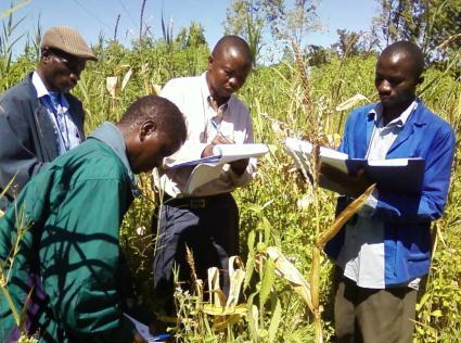
4 Diversity in Agriculture 4


5 5
6 GEO Global Agricultural Monitoring» G20 initiative on Global agricultural monitoring» to enhance agricultural production estimates through the use of Earth observations» to strengthen the international community s capacity» Community of Practise (international)» Workplan: 6 Components:» (Global & Regional Systems, National capacity development, Countries at risk, EO data coordination, R&D coordination, Data products & information dissemination)» Europe s contribution:» Copernicus Global Component» FP7 programme s & projects (AGRICAB, ISAC, )» & many more 6


7 USE?» RS based information Uptake by user communities 7


8 Develop Develop Methods & Indicators Learn Capacity building: supporting & training user communities Use Produce Operationally Produce Advanced Indicators Distribute Distribute and Share, using Geonetcast and other 8


9 Copernicus Initial Operations Global Land Service: Operationally Produce Advanced Indicators Timely production of 14 Global (Biophysical) parameters (Vegetation, Radiation, Water) Based on FP7 GEOLAND-2 processing chains Operations: VITO, IPMA, ZAMG with support science teams Evolution: HYGEOS, UCL, Uni Leicester, Uni Lisbon, TU Wien, INRA, EOLAB, IPMA, METEO- France, VITO Satellite data Input Processing and Archiving Product Dissemination 9


» Since 2000»")

10 Remote sensing Support to the European Commission» EC JRC MARSOP» Agricultural production?» Support to the European Commission Common Agricultural Policy (CAP)» Since 2000» Operational delivery remote sensing indicators and software CIS CCA WAF IGA ASI MCS SAC AFR 11


11 Montiroring Food Security in Africa
 based")


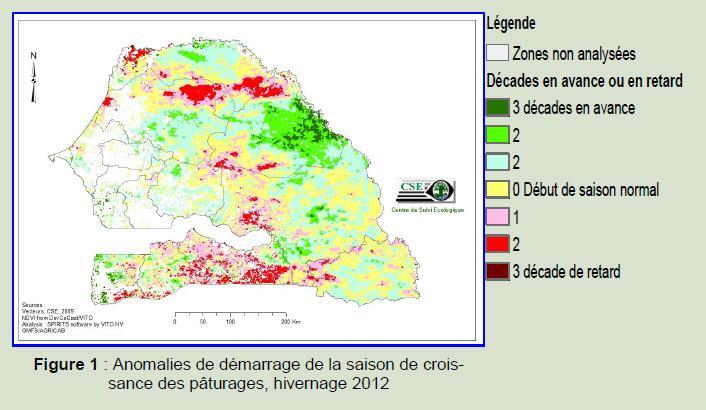
12 Development of a global Agricultural Drought Stress Index System (ASIS) based on remote sensing data ASIS is about monitoring vegetation drought stress only in crop growing season over crop areas on a sub-national level on a global scale Based on Vegetation Health Index ASIS serves the Global Information and Early Warning System (GIEWS) of FAO every 10 days with global maps to detect hotspots of drought in a Near Real Time mode. Percentage of crop area affected by drought in the first growing season of 2011 July 2008, NOAA Example for the 2011 drought in the Horn Of Africa
 Detailed needs assessment: commercial")
» Development of 3")
» Drought stress : damage")

 HR biophysical parameters:")

13 Information Service on Agricultural Change (ISAC FP7) Detailed needs assessment: commercial insurance sector, food security sector (early warning & micro-insurance)» Development of 3 prototype services:» High Resolution Biophysical Parameters (DMC/Deimos)» Drought stress : damage assessment for insurance» Agricultural change : crop models for insurance» Service demonstration in Belgium, Spain, Ethiopia (2012) Long term sustainability: (i) HR biophysical parameters: potential future Copernicus service (ii) Insurance products: potential downstream service for paying clients 15 15


 BEN SLIMANE")
14 cereal yield (qx/ha) Index-based insurance» Feasibility studies in Russia, Marocco, Ukraine, Senegal,.. demonstrating the usage of satellite based observations to support agricultural insurances BEN SLIMANE y = 0,1264x - 16,308 R² = 0, faparcum (D3 Feb - D2 Apr) BEN SLIMANE Linear (BEN SLIMANE) 16


» Insurance»")


15 Looking for more detail: monitoring and damage assessments at field level with HR satellite imagery (25m)» Insurance» Precision farming MODIS 10-daily synthesis, 250m, 1 April 2009 DMC, 25m 1 April 2009 Gemeente Zwevegem fapar index: return period for winter wheat, in /4 10/4 30/4 24/5 29/5 13/6 25/6 30/6 17


16 Capacity building: supporting & training user communities» AGRICAB (FP7), GMFS» Using Copernicus data sets to demonstrate» > 15 Workshops in the past 3 years» > 150 persons trained» Refresher & more advanced courses» > 20 workshops planned in the following 3 years» Training material» Tutorials, Excercises» Programme available online 18


17 SPOT-VEGETATION continuity: PROBA-V 19

18 Thank you! VITO - Flemish Institute for Technological Research Boeretang 200, 2400 B-Mol, Belgium lieven.bydekerke@vito.be; Tim.jacobs@vito.be; sven.gilliams@vito.be carolien.tote@vito.be; iabelle.piccard@vito.be; herman.eerens@vito.be; bruno.smets@vito.be ; dong.qinghan@vito.be 20
Sven Gilliams, VITO-TAP, 30/05/2017, IACS WS Gent. An eye on crops, thanks to global Satellite monitoring
 Sven Gilliams, VITO-TAP, 30/05/2017, IACS WS Gent An eye on crops, thanks to global Satellite monitoring VITO FLEMISH INSTITUTE FOR TECHNOLOGICAL RESEARCH: AREAS OF EXPERTISE Energy Materials Chemistry
Service: status & evolution
 The Copernicus Global Land Service: status & evolution R. Lacaze HYGEOS on behalf the GIO - Global Land consortium What is Copernicus? The European system for monitoring i the Earth The European response
SIGMA project. Overview
 SIGMA project Overview Background SIGMA - Facts Start 1 November 2013 30 March 2017 Agriculture AND Environment 22 partners, 17 countries VITO, CIRAD, JRC, IIASA, Alterra, RADI, NMSC, DEIMOS, GeoSAS, RCMRD,
M.Sc. Bio-Engineering (agriculture: crop growth and protection) High School
 High School") CURRICULUM VITAE ISABELLE PICCARD 1. Family name: Piccard 2. First names: Isabelle 3. Date of birth: 28/04/1974 4. Passport holder: Belgium 5. Residence: Belgium 6. Company: VITO 7. Education: Institution
CURRICULUM VITAE ISABELLE PICCARD 1. Family name: Piccard 2. First names: Isabelle 3. Date of birth: 28/04/1974 4. Passport holder: Belgium 5. Residence: Belgium 6. Company: VITO 7. Education: Institution
Crop Monitoring for Food Security from Space
 San Diego, 18-22 February 2010 AAAS Annual Meeting 1 Crop Monitoring for Food Security from Space Felix Rembold Joint Research Centre (JRC) The European Commission s Research-Based Policy Support Organisation
Evaluation of benefits and constraints for the use of Sentinel-2 for agricultural monitoring
 23/05/2014 Evaluation of benefits and constraints for the use of Sentinel-2 for agricultural monitoring Isabelle Piccard, Herman Eerens, Kris Nackaerts, Sven Gilliams, Lieven Bydekerke Sentinel-2 for Science
Crop Modelling & Yield Forecasting
 Crop Modelling & Yield Forecasting AGRICAB FINAL MEETING 23-24/03/2015 Hendrik Boogaard Alterra, WUR hendrik.boogaard@wur.nl WP31 Crop Production Systems Agricultural statistics Agro-meteorological modeling
Service Operations Report Crop Yield and Vegetation Monitoring
 GMFS Global Monitoring for Food Security Earth Watch GMES Services Element (GSE) ESA ESRIN/Contract No. 19402/05/I-LG To provide earth observation based services and encourage partnerships in monitoring
geoland GEOLAND Overview of Interacting parts and future plans Integrated GMES Project on Landcover and Vegetation
 Integrated GMES Project on Landcover and Vegetation GEOLAND Overview of Interacting parts and future plans Marc Leroy Jean-Christophe Calvet Marek Tinz Kees van Diepen Etienne Bartholomé Co-funded by the
GEOGLAM, Michel Deshayes, GEO, GEOGLAM Coordinator for the Agricultural Community of Practice
 GEOGLAM, Global Agricultural Monitoring Michel Deshayes, GEO, GEOGLAM Coordinator for the Agricultural Community of Practice GEO, Group on Earth Observations Created in 2005, to develop a coordinated and
Earth Observations based agricultural monitoring over EEU countries: concept and first results of the SIGMA RBK project
 Earth Observations based agricultural monitoring over EEU countries: concept and first results of the SIGMA RBK project Bartalev Sergey, Loupian Evgeny, Plotnikov Dmitry and Tolpin Vladimir Space Research
Collaboration of Space Research Institute NASU-SSAU with EC JRC on satellite monitoring for food security: background and prospects
 Collaboration of Space Research Institute NASU-SSAU with EC JRC on satellite monitoring for food security: background and prospects Prof. Nataliia Kussul 1 Space Research Institute NASU-SSAU, Ukraine Context
GEO Initiatives: GEOGLAM and AfriGEOSS
 GEO Initiatives: GEOGLAM and AfriGEOSS Andiswa Mlisa Michel Deshayes GEO Secretariat G4AWeek 21-24 September 2015, The Hague, Netherlands 87 Participating Organizations GEO Secretariat Information Value
Sentinels for Agriculture Global, Operational, Open, Reliable
 Sentinels for Agriculture Global, Operational, Open, Reliable Benjamin Koetz European Space Agency Earth Observation Directorate ESA UNCLASSIFIED - For Official Use Sentinel-2B Launch Tonight, 7 th of
Belmont Forum E-INFRASTRUCTURES & DATA MANAGEMENT. Collaborative Research Action SIGMA
 Belmont Forum E-INFRASTRUCTURES & DATA MANAGEMENT Collaborative Research Action SIGMA Capacity Development for Stimulating Innovation in Global Agricultural Monitoring Erwin Goor - VITO, Belgium Scoping
The GEO Global Agricultural Monitoring Initiative (GEOGLAM): Overview
: Overview") The GEO Global Agricultural Monitoring Initiative (GEOGLAM): Overview Chris Justice (UMD) 1 / 27 GEO the Group on Earth Observations an Intergovernmental Organization with 90 Members and 67 Participating
The GEO Global Agricultural Monitoring Initiative (GEOGLAM): Overview Chris Justice (UMD) 1 / 27 GEO the Group on Earth Observations an Intergovernmental Organization with 90 Members and 67 Participating
Service Validation Report Early Warning Services
 GMFS Global Monitoring for Food Security Earth Watch GMES Element (GSE) ESA ESRIN/Contract No. 19402/05/I-LG To provide earth observation based services and encourage partnerships in monitoring Global
DROUGHT IMPACT: DATA AVAILABILITY AND USE FOR ESTIMATION OF DROUGHT RISK. Drought Risk Assessment 6-8 November 2018 Budapest
 DROUGHT IMPACT: DATA AVAILABILITY AND USE FOR ESTIMATION OF DROUGHT RISK Dr.ir. Anne Gobin Drought Risk Assessment 6-8 November 2018 Budapest Acknowledgements: MERINOVA, cordex.be, ipot, BELCAM, AFTER
The MARS, GLOBCAST & GEOGLAM Crop Yield monitoring and Forecasting Systems and their potential Application in Bangladesh
 The MARS, GLOBCAST & GEOGLAM Crop Yield monitoring and Forecasting Systems and their potential Application in Bangladesh Jacques Delincé, Global Strategy ESS-FAO Rome Slides from: O. Léo (MARS-JRC) I.
Disaster Early Warning and Response Activities at RCMRD Tesfaye Korme (Ph.D), Regional Centre for Mapping of Resources for Development
, Regional Centre for Mapping of Resources for Development") Satellite Earth Observation & Disaster Risks Disaster Early Warning and Response Activities at RCMRD Tesfaye Korme (Ph.D), Regional Centre for Mapping of Resources for Development RCMRD and its member
Satellite Earth Observation & Disaster Risks Disaster Early Warning and Response Activities at RCMRD Tesfaye Korme (Ph.D), Regional Centre for Mapping of Resources for Development RCMRD and its member
GEOGLAM international cooperation activities
 GEOGLAM international cooperation activities Chris Justice Center for Global Agricultural Monitoring and Research Dept. of Geographical Sciences University of Maryland GEO: an International Coordinating
AfriGEOSS in the Next Decade of Developing the GEOSS Andiswa Mlisa
 AfriGEOSS in the Next Decade of Developing the GEOSS Andiswa Mlisa GEO Secretariat Africa Leadership Conference (ALC) 2015, Sharm El Sheik, Egypt, 1 4 December 2015 GEO Vision Ministers Adopted the GEO
User Awareness & Training: LAND. Tallinn, Estonia 9 th / 10 th April 2014 GAF AG
 User Awareness & Training: LAND Tallinn, Estonia 9 th / 10 th April 2014 GAF AG Day 2 - Contents LAND (1) General Introduction to EO and the COPERNICUS Sentinel Programme Overview of COPERNICUS/GMES LAND
GEOGLAM Global Agricultural Monitoring
 GEOGLAM Global Agricultural Monitoring Dr. Selma Cherchali on behalf of the GEOGLAM Crop Monitor team Land and Hydrology Program Manager Science, Application and innovation Directorate, CNES Co-Lead, CEOS
Introduction -session Mark Noort Latin America Geospatial Forum, Mexico City, 2014
 G-tech for agriculture Introduction -session Mark Noort Latin America Geospatial Forum, Mexico City, 2014 Scope In relation to crop farming and livestock farming, the term agriculture may be defined as:
Title. From a global ecosystem model to national studies on biomass estimation & livestock insurance (WP3.2 Livestock systems)
") Title From a global ecosystem model to national studies on biomass estimation & livestock insurance (WP3.2 Livestock systems) Julien Minet 1, Abdoul Aziz Diouf 1,2, Issa Garba 1,3, Marie Lang 1,4,5, Bakary
Title From a global ecosystem model to national studies on biomass estimation & livestock insurance (WP3.2 Livestock systems) Julien Minet 1, Abdoul Aziz Diouf 1,2, Issa Garba 1,3, Marie Lang 1,4,5, Bakary
Earth Observation for Crop Modelling
 Earth Observation for Crop Modelling International trends & developments How to promote earth observation applications? How to get funding? Capacity building 0. Introduction Mark Noort, consultant, project
Operational products for crop monitoring. Hervé Kerdiles, JRC MARS
 Operational products for crop monitoring Hervé Kerdiles, JRC MARS Outline Meteo products Rainfall, temperature, global radiation, ETa, snow depth Biomass indicators & crop yield prediction NDVI & other
WHEN SPACE MEETS AGRICULTURE
 WHEN SPACE MEETS AGRICULTURE Image from ESA Sentinel 14-15 November 2016 Matera, Italy Join the conversation #WSMA16 What can Copernicus do for farmers and for the European Agricultural Policy Catharina
The food security issue Remote Sensing tells us the truth! --- Bart Deronde
 The food security issue Remote Sensing tells us the truth! --- Bart Deronde Food Security exist when all people at all times have physical, social and economic access to sufficient, safe and nutritious
Land Surface Analysis SAF (LSA SAF)
") Ref. Ares(2014)73020-15/01/2014 Land Surface Analysis SAF (LSA SAF) Pedro Viterbo, Lisboa, Portugal Acknowledgments: Isabel Trigo & the LSA SAF consortium 12-13 December 2011 Lisbon Layout Overview of
Ref. Ares(2014)73020-15/01/2014 Land Surface Analysis SAF (LSA SAF) Pedro Viterbo, Lisboa, Portugal Acknowledgments: Isabel Trigo & the LSA SAF consortium 12-13 December 2011 Lisbon Layout Overview of
Summary of the socio-economic impact of Copernicus in the EU
 Summary of the socio-economic impact of Copernicus in the EU ESA Since the entry into service of Copernicus first satellite, Sentinel-1A, in 2014, the impacts of the programme are witnessed beyond the
ANTARES. EuroGEOSS Agriculture Pilot - outline. 1. EO Agriculture Monitoring - MARS, GEOGLAM and the current European contribution
 GEO-XIV - EuroGEOSS launch event EuroGEOSS Agriculture pilot Pr. Pierre Defourny, UCLouvain GEOGLAM/JECAM Co-lead With the contribution of collaborators and leaders of several EU programs and projects
The European Commission s science and knowledge service. Joint Research Centre
 The European Commission s science and knowledge service Joint Research Centre JRC MARS Crops yield forecasts: method and 2018 forecasts Bettina Baruth Brussels 11/07/2018 Table of content Mars Crop Yield
JECAM - Joint Experiment for Crop Assessment and Monitoring Recent progress with SAR/Optical Inter-Comparison Projects Ian Jarvis Co-lead of JECAM
 JECAM - Joint Experiment for Crop Assessment and Monitoring Recent progress with SAR/Optical Inter-Comparison Projects Ian Jarvis Co-lead of JECAM Science and Technology Branch, Agriculture and Agri-Food
GEOGLAM Global Agricultural Monitoring. Michel Deshayes
 GEOGLAM Global Agricultural Monitoring Michel Deshayes mdeshayes@geosec.org Outline GEOGLAM and AMIS GEOGLAM Structure and Governance New activities and projects Rangelands and Pasture Monitoring Early
Early Warning Systems on Food and Agriculture
 Early Warning Systems on Food and Agriculture Presentation by Stéphane Jost, Master in Human Development & Food Security Università Roma 3-18 May 2017 Early Warning Systems on Food and Agriculture Early
NASA Assets that Support of the Water- Energy-Food Nexus
 NASA Assets that Support of the Water- Energy-Food Nexus Richard Lawford 4 th Regional WEF Nexus Workshop Hilton, Pietermaritzburg, South Africa November 21, 2016 Observation Strategy for the Water Cycle
Towards cross-cutting land ECV consistency assessment through data assimilation
 Towards cross-cutting land ECV consistency assessment through data assimilation Jean-Christophe Calvet, Delphine Leroux, Clément Albergel, Alina Barbu, Simon Munier, Catherine Meurey CCI Soil Moisture
GEOGLAM : Global Agricultural Monitoring
 GEOGLAM : Global Agricultural Monitoring Jai Singh Parihar on behalf of GEOGLAM Task Team (Chris Justice, Shinichi Sobue, Olivier Leo, Wu Bingfang, Derrick Williams, Inbal Becker-Reshef, Ian Jarvis, Terry
GEOGLAM: G20 S GLOBAL AGRICULTURAL MONITORING INITIATIVE SPACE BASED EARTH OBSERVATIONS TO ENHANCE GLOBAL COMMODITY MARKET TRANSPARENCY
 GEOGLAM: G20 S GLOBAL AGRICULTURAL MONITORING INITIATIVE SPACE BASED EARTH OBSERVATIONS TO ENHANCE GLOBAL COMMODITY MARKET TRANSPARENCY Ian Jarvis (on behalf of GEO Agricultural Community of Practice)
GEOGLAM: Science-driven information supporting decisions in agricultural markets and food security through use of earth observations
 GEOGLAM: Science-driven information supporting decisions in agricultural markets and food security through use of earth observations Inbal Becker-Reshef Program Scientist GEOGLAM Secretariat Co-Director
 FP7- SPA.2013.1.1-06: Stimulating development of downstream services and service evolution. Contract N : 606983 A downstream service to support agro-production, planning and policy http://www.ermes-fp7space.eu/
Global Agricultural Monitoring International Coordination: GEOGLAM
 Global Agricultural Monitoring International Coordination: GEOGLAM Chris Justice NASA - Earth Observation for Food Security and Agriculture Consortium Department of Geographical Sciences, University of
Barrax JECAM Site (Spain)
") Barrax JECAM Site (Spain) JECAM/GEOGLAM Science Meeting Brussels, Belgium 16-17 November, 2015 Fernando Camacho Consuelo Latorre Fernando de la Cruz Location Site Description Barrax has been a study area
Barrax JECAM Site (Spain) JECAM/GEOGLAM Science Meeting Brussels, Belgium 16-17 November, 2015 Fernando Camacho Consuelo Latorre Fernando de la Cruz Location Site Description Barrax has been a study area
COMMITTEE ON COMMODITY PROBLEMS
 September 204 CCP 4/INF/9 E COMMITTEE ON COMMODITY PROBLEMS Seventieth Session, 7-9 October 204 PROGRESS REPORT ON THE AGRICULTURAL MARKET INFORMATION SYSTEM () This report summarizes progress in the implementation
AGRHYMET Assistance to NMSs In West Africa
 Workshop on "Achieving Benefits of Enhanced Service Delivery by NMSs in ESA AGRHYMET Assistance to NMSs In West Africa By Papa Oumar Dieye Head of Communication Outline of the Presentation Presentation
FAO-Rome as a form of technical support to the Global Information and Early Warning System (GIEWS)
") pixabay/17 Country-Level ASIS: an agriculture drought monitoring system Background The Food and Agriculture Organization of United Nations (FAO) has developed an agricultural drought monitoring system
pixabay/17 Country-Level ASIS: an agriculture drought monitoring system Background The Food and Agriculture Organization of United Nations (FAO) has developed an agricultural drought monitoring system
 FP7- SPA.2013.1.1-06: Stimulating development of downstream services and service evolution. Contract N : 606983 A downstream service to support agro-production, planning and policy http://www.ermes-fp7space.eu/
Agricultural Satellite Monitoring and Crop Yield Forecasting in. Who we are: Current Expertise & International Activities
 Agricultural Satellite Monitoring and Crop Yield Forecasting in Ukraine N. Kussul 1, S. Skakun 1, A. Shelestov 1,2 1 Space Research Institute NASU-SSAU 2 National University of Life and Environmental Sciences
World wide Monitoring System
 Crop Monitoring and Early Warning for Food-Security, the MARS-FOOD Approach Felix Rembold MARS-FOOD Action / AGRIFISH Unit Institute for Protection and Security of the Citizen MARS-FOOD Context and Objectives
Introduction to yield forecasting with CST
 Introduction to yield forecasting with CST H. Kerdiles (JRC), H. Boogaard & S. Hoek (Alterra) Harare, Zimbabwe 26 Oct 2016 Yield variability: can you rank the maize fields according to their yield? Same
MARS Crop monitoring and yield forecasting in the Mediterranean neighbourhood
 MARS Crop monitoring and yield forecasting in the Mediterranean neighbourhood Olivier Leo Monitoring Agricultural Resources Unit, Joint Research Centre Brussels, 30 September 2015 http://ies-intranet/h04/apps/chrono/21386.pptx
H2020 SENSAGRI project: developing prototypes for new Copernicus services for agriculture
 GEOINT for Environmental Compliance Assurance in rural areas/agriculture H2020 SENSAGRI project: developing prototypes for new Copernicus services for agriculture Antonio Ruiz Verdú University of Valencia
Monitoring and Assessment of Drylands: Forests, Rangelands, Trees, and Agrosilvopastoral Systems
 Workshop on Monitoring and Assessment of Drylands: Forests, Rangelands, Trees, and Agrosilvopastoral Systems Combining local surveillance and spatial observation for environmental monitoring in the Circum-Sahara:
Sentinels for Agricultural Monitoring Sen4CAP Concept & Goals
 Sentinels for Agricultural Monitoring Sen4CAP Concept & Goals Benjamin Koetz European Space Agency, Earth Observation Directorate Sentinels Looking after Agriculture ESA 28/11/2017 Slide 2 Copernicus Space
Joint Experiment for Crop Assessment and Monitoring GEOGLAM Implementation Meeting Washington D.C. February 21, 2013
 Joint Experiment for Crop Assessment and Monitoring GEOGLAM Implementation Meeting Washington D.C. February 21, 2013 Ian Jarvis JECAM Sub-Task Lead Earth Observation Service, Agriculture and Agri-Food
Copernicus products within the Czech Integrated Drought Monitoring System
 Copernicus products within the Czech Integrated Drought Monitoring System MONIKA BLÁHOVÁ GLOBAL CHANGE RESEARCH INSTITUTE CAS CZECH REPUBLIC Outline About Global Change Research Institute CAS (CzechGlobe)
DMC 22m Sensors for Supertemporal Land Cover Monitoring. Gary Holmes DMC International Imaging Ltd June 2014
 DMC 22m Sensors for Supertemporal Land Cover Monitoring Gary Holmes DMC International Imaging Ltd June 2014 DMC 2 nd Generation Satellites UK-DMC2 and Deimos-1 launched 29 th July 2009 650km swath width
Michel F. Massart DG ENTR - European Commission
 Michel F. Massart DG ENTR - European Commission COPERNICUS Program COPERNICUS Global Land component COPERNICUS Program Copernicus seen from the Regulation (GMES) Global Monitoring for Environment and Security
Earth Observation in Support of Science-Driven Policy & Decision Making: GEO Global Agricultural Monitoring (GEOGLAM)
") Earth Observation in Support of Science-Driven Policy & Decision Making: GEO Global Agricultural Monitoring (GEOGLAM) Alyssa Whitcraft Program Scientist, GEOGLAM Secretariat akwhitcraft@geooglam.org on
Earth Observation in Support of Science-Driven Policy & Decision Making: GEO Global Agricultural Monitoring (GEOGLAM) Alyssa Whitcraft Program Scientist, GEOGLAM Secretariat akwhitcraft@geooglam.org on
G l o b a l L a n d S e r v i c e
 G l o b a l L a n d S e r v i c e Mark Dowell European Commission JRC mark.dowell@ec.europa.eu http://land.copernicus.eu/global 2 M a n d a t e o f C o p e r n i c u s L a n d M o n i t o r i n g S e r
Early Warning Systems in Eastern
 Early Warning Systems in Eastern and Southern Africa: by Erick Khamala Senior Remote Sensing Officer RCMRD ekhamala@rcmrd.org Our Products and Services Training: i Geoinformation and IT applications,
The GEO Global Agricultural Monitoring (GEOGLAM) Initiative
 Initiative") The GEO Global Agricultural Monitoring (GEOGLAM) Initiative Chris Justice GEOGLAM Global Co-Lead The Center for Agricultural Monitoring Research, Department of Geographical Sciences, GEOGLAM Launched by
The GEO Global Agricultural Monitoring (GEOGLAM) Initiative Chris Justice GEOGLAM Global Co-Lead The Center for Agricultural Monitoring Research, Department of Geographical Sciences, GEOGLAM Launched by
Canadian Wildland Fire Information System (CWFIS)
") The Canadian Wildland Fire Information System in support of the National Forest Carbon Accounting System and the National Sustainable Development Strategy NRCan Initiative Earth Science Sector (ESS) and
The Canadian Wildland Fire Information System in support of the National Forest Carbon Accounting System and the National Sustainable Development Strategy NRCan Initiative Earth Science Sector (ESS) and
Sentinel-2 Agriculture project : Preparing Sentinel2 exploitation for agriculture monitoring
 Sentinel-2 Agriculture project : Preparing Sentinel2 exploitation for agriculture monitoring Defourny Pierre, Bontemps Sophie, CaraCozmin, Dedieu Gerard, Hagolle Olivier, Inglada Jordi, Thierry Rabaute,
THE CREATION OF SYSTEM OF WINTER CROPS CONTROL AND CROP YIELD FORECASTING USING SATELLITE DATA IN UKRAINE
 Scientific Center for aerospace research of the Earth, NAS of Ukraine THE CREATION OF SYSTEM OF WINTER CROPS CONTROL AND CROP YIELD FORECASTING USING SATELLITE DATA IN UKRAINE Prof. Vadim I. Lyalko, Dr.
CROP AREA ESTIMATES WITH MERIS DATA ON BELGIUM AND POLAND
 ISPRS Archives XXXVI-8/W48 Workshop proceedings: Remote sensing support to crop yield forecast and area estimates CROP AREA ESTIMATES WITH MERIS DATA ON BELGIUM AND POLAND P. Cayrol. a, *, H. Poilvé a,
AGRICULTURAL MARKET INFORMATION SYSTEM THIRD SESSION OF THE AMIS RAPID RESPONSE FORUM. Canberra, Australia. Thursday, 6 March 2014
 AMIS: RRF/3-2014/2 AMIS Agricultural Market Information System AGRICULTURAL MARKET INFORMATION SYSTEM THIRD SESSION OF THE AMIS RAPID RESPONSE FORUM Canberra, Australia Thursday, 6 March 2014 AMIS progress
Agricultural Risk Management and Forecasting
 World Meteorological Organization Working together in weather, climate and water Agricultural Risk Management and Forecasting Robert Stefanski Agricultural Meteorology Division Climate Prediction and Adaptation
CropWatch. Bingfang Wu Institute of Remote Sensing and Digital Earth (RADI) Chinese Academy of Sciences
 Chinese Academy of Sciences") CropWatch Bingfang Wu Institute of Remote Sensing and Digital Earth (RADI) Chinese Academy of Sciences Goal 2: Zero Hunger Pledges to end hunger, achieve food security, improve nutrition and promote sustainable
CropWatch Bingfang Wu Institute of Remote Sensing and Digital Earth (RADI) Chinese Academy of Sciences Goal 2: Zero Hunger Pledges to end hunger, achieve food security, improve nutrition and promote sustainable
GEO-CRADLE pre-kick-off Meeting Thursday, 17 th of February, Ufuk Sakarya, Ph.D. & Aziz Koru. TÜBİTAK UZAY Space Technologies Research Institute
 GEO-CRADLE pre-kick-off Meeting Thursday, 17 th of February, 2016 Ufuk Sakarya, Ph.D. & Aziz Koru TÜBİTAK UZAY Space Technologies Research Institute IONIC Centre, 11 Lysiou Street Athens, Greece TÜBİTAK
EO4SDGs and Disaster Risk Reduction Virginia Burkett Chief Scientist, USGS Climate and Land Use Change
 EO4SDGs and Disaster Risk Reduction Virginia Burkett Chief Scientist, USGS Climate and Land Use Change U.S. Department of the Interior U.S. Geological Survey United Nations (2015): Sendai Framework for
COMMITTEE ON COMMODITY PROBLEMS
 July 2018 CCP 18/INF/6 E COMMITTEE ON COMMODITY PROBLEMS Seventy-second Session Rome, 26 28 September 2018 THE AGRICULTURAL MARKET INFORMATION SYSTEM (AMIS) Queries on the substantive content of the document
PROBA-V MISSION EXPLOITATION PLATFORM ERWIN GOOR, VITO
 PROBA-V MISSION EXPLOITATION PLATFORM ERWIN GOOR, VITO VITO COMPANY PROFILE VITO - Flemish Institute for Technological Research, Belgium 750 employees, 26 nationalities, 140 mio turnover in 2014 Remote
Towards a Global Agricultural Monitoring System of Systems. Chris Justice University of Maryland ( Ag 0703 Task Lead )
") Towards a Global Agricultural Monitoring System of Systems Chris Justice University of Maryland ( Ag 0703 Task Lead ) IRSA Beijing, Feb 11-13 th 2009 World food and agriculture are facing critical challenges
Towards a Global Agricultural Monitoring System of Systems Chris Justice University of Maryland ( Ag 0703 Task Lead ) IRSA Beijing, Feb 11-13 th 2009 World food and agriculture are facing critical challenges
The EUMETSAT Satellite Application Facility on Land Surface Analysis (LSA SAF) Continuous Development 2 Phase
 Continuous Development 2 Phase") The EUMETSAT Satellite Application Facility on Land Surface Analysis (LSA SAF) Continuous Development 2 Phase Jean-Louis Roujean and many co-authors METEO FRANCE / Toulouse jean-louis.roujean@meteo.fr
The EUMETSAT Satellite Application Facility on Land Surface Analysis (LSA SAF) Continuous Development 2 Phase Jean-Louis Roujean and many co-authors METEO FRANCE / Toulouse jean-louis.roujean@meteo.fr
Space-Based Information for Flood and Drought Risk Reduction
 United Nations/Germany Expert Meeting Space-Based Information for Flood and Drought Risk Reduction 5-6 June 2014 Bonn, Germany Images: NASA Discussion Sessions Guiding Questions & Background Information
GEOGLAM Crop Assessment Tool
 GEOGLAM Crop Assessment Tool Supporting Evidence for the Crop Monitor Michael Humber, Jon Nordling Inbal Becker-Reshef, Brian Barker, Katie McGaughey, Chris Justice, Michel Deshayes Center for Global Agricultural
Role and importance of Satellite data in the implementation of the COMIFAC Convergence Plan
 Plenary Meeting of the Congo Basin Forest Partnership (CBFP) Palais des Congrès, Yaoundé. Cameroon 11-12 November, 2009 Role and importance of Satellite data in the implementation of the COMIFAC Convergence
CILSS / AGRHYMET Role in The Reduction of Food Crises and Other Hydroclimatic Disasters in West Africa
 CILSS / AGRHYMET Role in The Reduction of Food Crises and Other Hydroclimatic Disasters in West Africa 1 Context Outline The Sahel droughts of the early 1970s and the Creation of CILSS Monitoring and Early
Developing a Global Agricultural Monitoring System of Systems. Context for Agriculture Monitoring. Chris Justice University of Maryland
 Developing a Global Agricultural Monitoring System of Systems Chris Justice University of Maryland IRSA Beijing, Feb 11-13 th 2009 Energy and Food Prices Closely Linked Energy prices affect ag inputs,
Status of the GEOGLAM Initiative
 Status of the GEOGLAM Initiative Alyssa K. Whitcraft CEOS SIT-31 Side Meeting - 21 April 2016 University of Maryland/GEOGLAM Secretariat akwhitcraft@geoglam.org Topics April 2016 New Website www.geoglam.org
Use of Remote Sensing Imagery for GeoTraceability in Agriculture
 Use of Remote Sensing Imagery for GeoTraceability in Agriculture STEREO & VEGETATION Workshop 6 May 2004 - Brussels CENTRE WALLON DE RECHERCHES AGRONOMIQUES Biometry, Data management and Agrometeorology
Reinhard Blasi EGNOS and Galileo in Agriculture. European GNSS Agency Market Development
 Reinhard Blasi EGNOS and Galileo in Agriculture European GNSS Agency Market Development Agenda 2 European GNSS Agency GSA EGNOS and Galileo in Agriculture Main Applications in Precision Agriculture Differences
Sentinel-2 for agriculture and land surface monitoring from field level to national scale
 Sentinel-2 for agriculture and land surface monitoring from field level to national scale The on-going BELCAM, Sen2-Agri and LifeWatch experiences C. Delloye, S. Bontemps, N. Bellemans, J. Radoux, F. Hawotte,
Adaptation Clearinghouse for Europe and EEA information needs
 Workshop IS-ENES (InfraStructure for the European Network for Earth System Modelling) on Bridging Climate Research Data and the Needs of the Impact Community, 11-12 January 2011, EEA/Copenhagen Adaptation
ASAP - Anomaly hot Spots of Agricultural Production, a new early warning decision support system developed by the Joint Research Centre
 ASAP - Anomaly hot Spots of Agricultural Production, a new early warning decision support system developed by the Joint Research Centre Felix Rembold, Michele Meroni, Ferdinando Urbano, Guido Lemoine,
GMES and AFRICA
 Global Monitoring for Environment and Security Mauro.Facchini@ec.europa.eu GMES and AFRICA What is GMES? European response to global needs to manage the environment, understand and mitigate the effects
ChloroGIN Addressing GEO Task EC-09-01c: Regional Networks for Ecosystems
 Addressing GEO Task EC-09-01c: Regional Networks for Ecosystems Stewart Bernard (CSIR, South Africa), Mark Dowell (JRC, Italy), Steve Groom (PML, UK), Nicolas Hoepffner (JRC, Italy), Milton Kampel (INPE,
COMPARISON OF BIOPHYSICAL AND SATELLITE PREDICTORS FOR WHEAT YIELD FORECASTING IN UKRAINE
 The International Archives of the Photogrammetry, Remote Sensing, and Spatial Information Sciences, Volume XL-7/W3, 2015 COMPARISON OF BIOPHYSICAL AND SATELLITE PREDICTORS FOR WHEAT YIELD FORECASTING IN
SEN4CAP Sentinels for Agriculture Monitoring
 SEN4CAP Sentinels for Agriculture Monitoring Bontemps S., Defourny P., Bajec K., Bellemans N., Joshi N., Kucera L., Mammone C., Milcinski G., L. Rossi, C. Sciarretta, F. Tutunaru, F. Volpe, M. Zavagli,
SPECIAL FOCUS February Persistent rainfall deficits lead to contracted sown area and impeded crop development across parts of Southern Africa
 SPECIAL FOCUS February 2019 Persistent rainfall deficits lead to contracted sown area and impeded crop development across parts of Southern Africa The delayed onset of the 2018/19 rainy season in many
Remote sensing for index insurance. Findings and lessons so far
 Remote sensing for index insurance Findings and lessons so far This publication was developed for the Weather Risk Management Facility of the International Fund for Agricultural Development and the World
PROBA-V MISSION EXPLOITATION PLATFORM UPDATE AFTER ITERATION 1 ERWIN GOOR, VITO
 PROBA-V MISSION EXPLOITATION PLATFORM UPDATE AFTER ITERATION 1 ERWIN GOOR, VITO PROBA-V MEP OVERVIEW https://proba-v-mep.esa.int/ Geo Viewer Time Series Viewer N-daily Compositor Request Virtual Machine
Early warning analysis for crop and pastureland in Senegal: a contribu8on to food security. Title
 Early warning analysis for crop and pastureland in Senegal: a contribu8on to food security Diop Mouhamadou Bamba 1, Diouf Abdoul Aziz 1,4, Faye Gayane 1, Tote Carolien 2, Royer Antoine 2, El Hadji M. Dieng
EU-Africa collaboration on Space applications for Africa
 EU-Africa collaboration on Space applications for Africa Background Maputo Declaration: African policy makers request EC to open its GMES initiative to Africa (Oct 2006) Build on existing EO activities
GMFS Global Monitoring for Food Security
 GMFS Global Monitoring for Food Security Earth Watch GMES Services Element (GSE) ESA ESRIN/Contract No. 19402 To provide earth observation based services and encourage partnerships in monitoring Global
CGMS-Maroc: National System for Agrometeorological monitoring
 CGMS-Maroc: National System for Agrometeorological monitoring Mouanis LAHLOU Hassan II Institute of Agronomy and Veterinary Medicine On behalf : Balagui R., Arrach R., El Hairech T., Ajerame M.M., Content
GMFS Final Report Stage 1 and Stage 2
 GMFS Global Monitoring for Food Security Earth Watch GMES Services Element (GSE) ESA ESRIN/Contract No. 19402 To provide earth observation based services and encourage partnerships in monitoring Global