Core Service Land. Information Day for the 2nd FP7 Space Call 10th September 2008, Prag. Alexander Kaptein, geoland2 coordinator. geoland2 consortium
|
|
|
- Trevor Knight
- 6 years ago
- Views:
Transcription

1 Core Service Land Information Day for the 2nd FP7 Space Call 10th September 2008, Prag Alexander Kaptein, geoland2 coordinator European Commission Fast Track Service Land within the GMES initiative in FP-7 consortium What is needed Europe s environment under pressure Water 20% of all surface water sources seriously threatened by pollution Soil Erosion 17% of total European land area affected, economic loss around 85 per ha Biodiversity 335 species highly endagered in Europe Agriculture intensification leads to water stress, soil erosion and biodiversity decline Urban Settlements and transport networks growing - leads to soil sealing and fragmentation of landscape Responsible management requires adequate geo-information 22

 geoland geoland OWS-W OWS-W Pesticide")


2 2 geoland What geoland could provide Validation and demonstration of services Soil Soil Erosion Erosion Risk Risk (Chania, Crete) (Chania, Crete) geoland geoland OWS-W OWS-W Pesticide Loss (Unstrut catchment, Germany) geoland OWS-W 11 Sep geoland Urban Urbangrowth growthvs. vs. Population Populationgrowth growth geoland OSP geoland OSP &&ESPON ESPON project project FP7 2nd Space Call Info Day, Prague 33 What geoland could provide Validation and demonstration of services LAI Crop Yield Forecast Map Huabei province, China ERS/scatt Soil Water Index geoland OFM & European Development Fund 11 Sep 2008 FP7 2nd Space Call Info Day, Prague 44


3 Core Services linking GMES domains Flood Risk Information System: Up-to-date Land Use With Flood Extent Damage Potential in /km² Geo-Information System / Risk Maps GSE RISK EOS II 55 The logic behind core services Examples Land Take Monitoring (Soil Sealing) Water Quality (Diffuse Pollution) * Percentage of of Costs % 35% Land Take Land Take Trend Analysis Add-on Classes & Time Series Add-on Classes & Time Series 56% Fast Track Service Land Monitoring Pilot Service Land Monitoring Percentage of of Costs % Inland Water Quality** 12% 88% Inland Water Quality (Pesticides // Nutrients Fast Track Service Land Monitoring Pilot Service common core services cost saving for all affordable downstream services 66
4 Expectations Satellite Satellite observations observations In-situ In-situ observations observations Ancillary Ancillary data data Land Land Monitoring Monitoring Core Core Service Service -LMCS -LMCS - - Downstream Downstream services services LMCS LMCS --3 dimensions dimensions geographical scale geographical scale global global continental continental local local time scale time scale near real-time services producing information on daily, near weekly real-time or monthly services basis producing information on daily, weekly or monthly basis periodic services producing information on annual or periodic multi-annual services basis producing information on annual or multi-annual basis level of elaboration or complexity level of elaboration or complexity basic services basic services adaptive services adaptive services 77 Expectations Land Monitoring Core Service List List of of services to to be be covered: Ortho-rectification LU/LC ground survey Reference mapping LC LC and LCC mapping Global Continental Local QA/QC Product dissemination Data archiving 88
5 Expectations LMCS LMCS milestones extension to to local local component (urban (urban atlas) atlas) (bi-)annual satellite satellite data data coverage (20 (20 m) m) in-situ in-situ reference sites sites progressive increase increase LC LC classes classes FTS FTS Inspire Inspire data data specifications land land cover cover 2009 extension to to global global land land monitoring extension to to change change monitoring 2010 Corine Corine Land Land cover cover update update (tbd) (tbd) Inspire Inspire compliant national national LC LC mapping mapping 99 Land Monitoring Core Service (LMCS) & geoland2 service implementation logic Fast Core Track Mapping Implementation Service (CMS) (Fast Track system implementation) Service Evolution Core Information Services (Service Evolution) Local Local Component Continental Continental Component Component Global Global Component Component higher UrbanAtlas resolution data of builtup areas in a Europe-wide / Land data Cover covering Change) the whole (acc. to LMCS Implementation EUROLAND generic(land land-cover/land Cover use Biophysical Not applicable parameters standardised EUROLAND form, covering all European EUROLAND continent plan) BioPar major European agglomerations Annual / Seasonal Change Monitoring Thematic elements, at both Local and Continental level, SATCHMO bio-physical parameters dedicated Spatial to specific Water European Forest and MS policies Agri-Env. which can be Land of and global Natural land cover Global data Planning interest for a large Monitoring community Monitoring of users such Monitoring as: soil protection, Carbon and more Resource thematic Crop waste management, agriculture (IACS, etc..), hydrologic maps, information on desertification, etc. Water Forest AgriEnv Mon. for Monitoring deforestation, Africa food security GCM NARMA Logic: CMS: produce to verify service infrastructure (throughput, robustness, quality) CIS: using this input to validate benefit / end-user utility together with in-situ data, models 10


6 Downstream Services 11 Monitoring Concept Core Mapping Services Resolution Year 1 Year 2 Year 3 Year 4 Year 5 Year 6 Annual Sampling Local VHR Urban Atlas Urban Atlas Cont. HR Wall-to-wall EEA 38 coverage update every 3-5 years Global MR/LR NRT to Seasonal Monitoring (continuous) 12
7 Core Mapping Service Lines UrbanAtlas (inventory, up-date) LC/LCC (inventory, up-date) Seasonal / annual vegetation monitoring Area Frame Sampling (change tracking) Bio-physical parametres VHR, ha 15 cities upd. & 30 cities quick up-date indicators 3 5 yrs. HR, 1 5 ha EU-27 (selected layer), large area demos (all layers) 3 5 yrs. MR, m, large area demos 2 3 data takes / season VHR image samples yearly MR LR Monthly seasonally UrbanAudit support for DG REGIO, DG ENV (Quality of Life, Cohesion Policy Impact) WFD, STS, CAP, Spatial Policy key land cover / land use objects (inputs to statistics, models) Support of LC/LCC mapping to increase thematic accuracy (e.g. grassland, transition classes) & track seasonal classes (e.g. agriculture) climate variability key driver for WFD, STS, CAP applications Track & understand change dynamics Monitor European / Global bio-physical parametres as key input to Water and Carbon Cycle monitoring, water mgmt, crop monitoring, African land mgmt. 13 Context previous and parallel activities Operations Implementation Consolidation EC-FP-6 Integrated Projects ESA GMES Service Elements GSE CoastWatch geoland + VGT4Africa, VGT@Work, PUMA GMES Urban Services GMES SAGE GMES Forest Monitoring / GSE FM GMFS Operational Programmes (no timeline given) GMES LMCS (Land Monitoring Core Service) GSE Land Information Services GMFS GlobCover, GlobCarbon geoland+ (Boss4GMES) MARS / JRC, ACP Observatory / JRC AMESD / EDF, SAF Land / Eumetsat FTS/CLC2006 /EEA FP 7 Preparatory Actions tbd. UrbanAtlas/DG Regio FP7 / 2008 downstream services call climate change call GSE Extensions VAE Value Added Element DUE Data User Element EDF European Dev. Fund Operational up-take Operational GMES budgets Downstream Services Interreg III / IV-RFEC, LIFE+, nat./regional funding National For example Operational: national land monitoring (e.g. ES, UK, SE, FI, HU) R&D: DE (DECOVER), FR, AT 14
8 How to make GMES a success? (1/2) Ubiquitous availability of standardised core services to enable downstream applications Image Data - Image2000, Image2006, UrbanAtlas VHR data (2.5 m), scientific medium-/low-resolution data series available, FP7 data access through ESA up-coming (e.g. Image2009) Core Service Data EEA FTS/CLC2006 / 2009 /, EC UrbanAtlas, EC Preparatory Actions, FP7 FTS project geoland2 In-situ Data bi-lateral negotiations necessary, some EEA EIONET data collections, INSPIRE / SEIS / national SDI availability will only take midterm effects Access / Dissemination Tools EEA web services, JRC CID (community image data portal), ESA portal?, joint Land portal Common standards (content, format, service / system interoperability) INSPIRE, OGC, GMES service de facto standards evolving Core Serivce Data availability not perfect, but reasonably well to run a range of downstream services 15 How to make GMES a success? (1/2) Broad up-take by consolidated and new down-stream services Market penetration of established services Interreg, LIFE+ offer EC inventives to regions, GSE / VAE / DUE / EDF offer support to international roll-out Service evolution/integration into scenario / management tools a FP7 downstream call opportunity? New services addressing further fields (e.g. climate change adaptation, public customers outside Europe, commerical customers) a FP7 downstream call opportunity (maybe together with the Climate call?) Stakeholder teaming to achieve consensus continuing Governance to achieve operational budgets and procurement evolving GMES technically and politically mature enough to justify further down-stream service investments 16


9 Euroland existing LMCS-type data Joint Web-Map Server & Portal (from 16th 16th Sep. Sep CMS Demonstration Sites 18


10 CMS Demonstration Sites 19 CIS Demonstration Sites 20

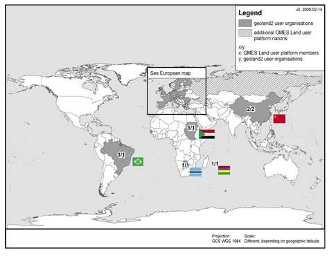
11 CIS Demonstration Sites 21 GMES Land User Platform 22
 EARSC Science Platform EARSEL supported by geoland2 to strengthen land")
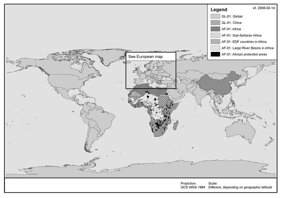
12 African User Involvement African User involvement user feedback from AMESD ACP Observatory acting as agency 23 Further Stakeholder Activities Service Provider Associations Landnetwork new association to support teaming & pursue specific interest of land service providers (in co-ordination with general EARSC activities) EARSC Science Platform EARSEL supported by geoland2 to strengthen land oriented working groups & to organise broader scientific exchange GEO / GEOSS Direct collaboration through FTS Land representation to promote the European Land contribution (geoland, Boss4GMES, geoland2) GOFC-GOLD collaboration for land specific standards INSPIRE SDIC geoland 24
13 Contact Alexander Kaptein geoland coordinator Astrium Services / Infoterra E. Alexander.Kaptein@astrium.eads.net T Andreas Littkopf GMES Land User Platform coordinator ETC Land Use and Spatial Information (ETC-LUSI) E. andreas.littkopf@uab.es T (see Window on GMES brochure), terrestrial.eionet.europa.eu (see GMES Land User Newsletter editions) The GMES Land Portal & Web-Map Server (from 16th September 2008) 25
geoland GEOLAND Overview of Interacting parts and future plans Integrated GMES Project on Landcover and Vegetation
 Integrated GMES Project on Landcover and Vegetation GEOLAND Overview of Interacting parts and future plans Marc Leroy Jean-Christophe Calvet Marek Tinz Kees van Diepen Etienne Bartholomé Co-funded by the
Service: status & evolution
 The Copernicus Global Land Service: status & evolution R. Lacaze HYGEOS on behalf the GIO - Global Land consortium What is Copernicus? The European system for monitoring i the Earth The European response
Kopernikus Land Monitoring Service - Global Component. Espen Volden GMES Bureau
 Kopernikus Land Monitoring Service - Global Component Espen Volden GMES Bureau GMES -> KOPERNIKUS Started in 1998 2008 a milestone: (pre-)operational services GMES Forum Lille 16-17/9 2008 Name change
Joint Research Centre
 Joint Research Centre The European Commission s in-house science service www.jrc.ec.europa.eu Serving society Stimulating innovation Supporting legislation Who are we and what do we do? JRC is the European
Status of GSE - GMES Services Element
 Status of GSE - GMES Services Element Luigi Fusco ESA/ESRIN HALO Workshop, ECMWF, 16-17 November 2004 overview Introduction GSE as part of GMES 1. GSE consolidation phase 2. GSE and the Initial Services
Key elements of the GMES EC Draft Action Plan Initial Period
 Brussels, 27/07/2001 Key elements of the GMES EC Draft Action Plan Initial Period 2001-2003 For information: Michel.Cornaert@cec.eu.int Hugo.De_Groof@cec.eu.int Neil.Hubbard@jrc.it Errol.Levy@cec.eu.int
JOINT RESEARCH CENTRE - Work Programme 2010 Action n SOIL - Soil Data and Information Systems
 JOINT RESEARCH CENTRE - Work Programme 2010 Action n 22004 - SOIL - Soil Data and Information Systems Institute for environment and sustainability (Ispra) Policy Theme: 2 - Solidarity and the responsible
EU-Africa collaboration on Space applications for Africa
 EU-Africa collaboration on Space applications for Africa Background Maputo Declaration: African policy makers request EC to open its GMES initiative to Africa (Oct 2006) Build on existing EO activities
European environmental reporting and policy analysis
 EIONET NRC SOIL Ispra, ITALY 10-12 December 2012 Data requirements for NFP/Eionet Meeting 29 February 2012 European environmental reporting and policy analysis Geertrui Louwagie Ecosystems assessment group
+GIO-land. European Land Monitoring Activities in the frame of Copernicus Programme
 +GIO-land European Land Monitoring Activities in the frame of Copernicus Programme Gyorgy.Buttner@eea.europa.eu International LCLUC Regional Science Meeting in Central Europe, 16-22 October 2014, Sopron,
JOINT RESEARCH CENTRE - FP7 - WP2009 Action n SOIL - Soil Data and Information Systems
 JOINT RESEARCH CENTRE - FP7 - WP2009 Action n 22004 - SOIL - Soil Data and Information Systems (SOIL) Institute for environment and sustainability Policy Theme: 2 - Solidarity and the responsible management
Joint Research Centre
 Joint Research Centre The European Commission s in-house science service www.jrc.ec.europa.eu Serving society Stimulating innovation Supporting legislation Established 1957 7 institutes in 5 countries:
State of Environment reporting on water and the Water Information System for Europe (WISE)
") WFD Lille 2007 State of Environment reporting on water and the Water Information System for Europe (WISE) Stefan Jensen EEA Agenda EEA needs for SoE reporting and water data Indicator based assessments
WFD Lille 2007 State of Environment reporting on water and the Water Information System for Europe (WISE) Stefan Jensen EEA Agenda EEA needs for SoE reporting and water data Indicator based assessments
Institute for Environment and Sustainability
 JRC Institute for Environment and Sustainability 1 Institute for Environment and Sustainability Prof. Dr Leen Hordijk Director Our strategic goals JRC Institute for Environment and Sustainability 2 Strategic
Land Use and Soil Protection in Europe
 EUROSOIL 2008 1 Land Use and Soil Protection in Europe Luca Montanarella European Commission Agriculture in Europe: Shaping the environment over the past 5000 years EUROSOIL 2008 2 Human Impact in Europe
GMES Global Monitoring for Environment and Security
 GMES Global Monitoring for Environment and Security Mikko Strahlendorff Programme manager at GMES Bureau DG Enterprise & Industry - Euu ropp eaa n C omm mii sss ionn Need for information Need for information
MAES Soil Pilot state of play
 MAES Soil Pilot state of play Jacques Delsalle DG ENV B1 WG MAES 17/09/2015 What happened since last meeting? Call for manifestation of interest Dec 2014 Scoping meeting on 29/1/2015 (BE, FI, NL + EC)
Overview of Fire Related Tasks in GEOSS/GEO
 Global Observation of Forest and Land Cover Dynamics Overview of Fire Related Tasks in GEOSS/GEO Michael Brady 2nd Workshop on Geostationary Fire Monitoring and Applications Darmstadt, 4-6 December 2006
Land Resource Management Unit
 09/01/2013 Land Resource Management Unit www.jrc.ec.europa.eu Alan Belward Serving society Stimulating innovation Supporting legislation 1 Visit of Deputy DG Land Resource Management Unit s mission To
MESA IGAD THEMA SERVICES. Region. Mr Zachary K.K. Atheru RIC Manager
 MESA IGAD THEMA SERVICES MESA main successes in the IGAD Region By Mr Zachary K.K. Atheru RIC Manager INTRODUCTION Associated countries Djibouti, Eritrea, Ethiopia, Kenya, Somalia, South Sudan, Sudan,
User Awareness & Training: LAND. Tallinn, Estonia 9 th / 10 th April 2014 GAF AG
 User Awareness & Training: LAND Tallinn, Estonia 9 th / 10 th April 2014 GAF AG Day 2 - Contents LAND (1) General Introduction to EO and the COPERNICUS Sentinel Programme Overview of COPERNICUS/GMES LAND
EU contribution to R&D in GEO
 EU contribution to R&D in GEO Luca Perez European Commission Directorate General for Research & Innovation Unit I.4 Climate Change and Natural hazards Outline EU Framework Programmes for Research and Technological
AND ACTION PLAN EEA/EIONET SUPPORT TO THE FITNESS CHECK ACTIONS ACTION PLAN
 Workshop on Streamlining Environmental Reporting Tallinn, 7-8 November 2017 EEA/EIONET SUPPORT TO THE FITNESS CHECK ACTIONS AND EEA/EIONET SUPPORT TO THE FITNESS CHECK ACTIONS ACTION PLAN CHRIS STEENMANS
Adaptation Clearinghouse for Europe and EEA information needs
 Workshop IS-ENES (InfraStructure for the European Network for Earth System Modelling) on Bridging Climate Research Data and the Needs of the Impact Community, 11-12 January 2011, EEA/Copenhagen Adaptation
Use of CORINE Land Cover in delivering the EEA strategy
 Use of CORINE Land Cover in delivering the EEA strategy Prof. Jacqueline McGlade Executive Director EIONET Member Countries national teams / co-funding Commission Services: Acknowledgements JRC: joint
G l o b a l L a n d S e r v i c e
 G l o b a l L a n d S e r v i c e Mark Dowell European Commission JRC mark.dowell@ec.europa.eu http://land.copernicus.eu/global 2 M a n d a t e o f C o p e r n i c u s L a n d M o n i t o r i n g S e r
A downstream service to support agro production, planning and policy. FP7 SPACE CALL Contract N :
 A downstream service to support agro production, planning and policy FP7 SPACE 2013 1 CALL Contract N : 606983 Project coordinator Mirco Boschetti CNR IREA PROJECT FRAMEWORK Who is ERMES (H)ermes (/ˈhɜrmiːz/;
DANUBEparksCONNECTED Workshop Corridor Land
 DANUBEparksCONNECTED Workshop Corridor Land 06.-07. April 2017, Spitz a. D., Wachau, Austria Copernicus Land Monitoring Services: from satellite data to ecosystem condition, ecosystem services and green
GMES and AFRICA
 Global Monitoring for Environment and Security Mauro.Facchini@ec.europa.eu GMES and AFRICA What is GMES? European response to global needs to manage the environment, understand and mitigate the effects
BRAGMA. Bridging Actions for GMES & Africa. Origins of GMES and Africa NEWSLETTER 8 DECEMBER 2013
 BRAGMA Bridging Actions for GMES & Africa NEWSLETTER 8 DECEMBER 2013 The BRAGMA project, coordinated by IICT is a Coordination and Support Action to GMES and Africa, supported by the European Commission.
GEO-CRADLE project in context of regional needs
 GEO-CRADLE project in context of regional needs Funded under H2020 - Climate action, environment, resource efficiency and raw materials ACTIVITY: Developing Comprehensive and Sustained Global Environmental
ANNEX. to the. Commission Implementing Decision. on the adoption of the 2017 Copernicus Work Programme
 EUROPEAN COMMISSION Brussels, 27.1.2017 C(2017) 366 final ANNEX 1 ANNEX to the Commission Implementing Decision on the adoption of the 2017 Copernicus Work Programme EN EN ANNEX to the Commission Implementing
ANNEX. to the COMMISSION IMPLEMENTING DECISION. on the adoption of the Work programme 2018 and on the financing of the Copernicus Programme
 EUROPEAN COMMISSION Brussels, 10.1.2018 C(2018) 2 final ANNEX 1 ANNEX to the COMMISSION IMPLEMENTING DECISION on the adoption of the Work programme 2018 and on the financing of the Copernicus Programme
Adaptation to climate change in river basin management planning in the EU policy context and research trends
 WFD Lille 2010 Adaptation to climate change in river basin management planning in the EU policy context and research trends Balázs Horvath, Philippe Quevauviller Adaptation to climate change in river basin
European Soil Data Centre (ESDAC): Soil data infrastructure for research and policy making in Europe
: Soil data infrastructure for research and policy making in Europe") European Soil Data Centre (ESDAC): Soil data infrastructure for research and policy making in Europe Ana Payá Pérez, Panos Panagos & Marc Van Liedekerke Convegno sul tema: Evento internazionale EUGRIS:
European Soil Data Centre (ESDAC): Soil data infrastructure for research and policy making in Europe Ana Payá Pérez, Panos Panagos & Marc Van Liedekerke Convegno sul tema: Evento internazionale EUGRIS:
e-reporting in the EU and links to INSPIRE
 e-reporting in the EU and links to INSPIRE Workshop: Metadata for Air Quality and Atmospheric Composition, GEO group for Earth Observations, Air Quality Community of Practice Sheila Cryan, European Environment
The Blueprint and Council Conclusions:
 The Blueprint and Council Conclusions: Essential to address the challenges that threaten the water ecosystems and their services on which society depends Proposed solutions include assessment of the costs
Control Methods Workshop Welcome and background
 Control Methods Workshop 2012 Welcome and background Neil Hubbard, Head of MARS Unit www.jrc.ec.europa.eu Serving society Stimulating innovation Supporting legislation Who are we and what do we do? JRC
 Development of a European Drought Observatory and Drought Research Jürgen Vogt & Paulo Barbosa European Commission Joint Research Centre (JRC) Institute for Environment and Sustainability (IES) Action
Chart 2 > Vortrag > Autor Dokumentname > Datum
 www.dlr.de Chart 1 > Vortrag > Autor Dokumentname > Datum www.dlr.de Chart 2 > Vortrag > Autor Dokumentname > Datum www.dlr.de Chart 3 > Vortrag > Autor Dokumentname > Datum www.dlr.de Chart 4 > Vortrag
CROP AREA ESTIMATES WITH MERIS DATA ON BELGIUM AND POLAND
 ISPRS Archives XXXVI-8/W48 Workshop proceedings: Remote sensing support to crop yield forecast and area estimates CROP AREA ESTIMATES WITH MERIS DATA ON BELGIUM AND POLAND P. Cayrol. a, *, H. Poilvé a,
Early Warning Systems in Eastern
 Early Warning Systems in Eastern and Southern Africa: by Erick Khamala Senior Remote Sensing Officer RCMRD ekhamala@rcmrd.org Our Products and Services Training: i Geoinformation and IT applications,
UAV assessment to support EU policies
 UAV assessment to support EU policies Elena Roglia Max Craglia www.jrc.ec.europa.eu Serving society Stimulating innovation Supporting legislation Sistema di Monitoraggio Avanzato del Territorio SMAT SMAT
EEA work on ecosystems assessments support to MAES. Annemarie Bastrup-Birk, Markus Erhard (EEA) Dania Abdul Malek (ETC/SIA)
 Dania Abdul Malek (ETC/SIA)") EEA work on ecosystems assessments support to MAES Annemarie Bastrup-Birk, Markus Erhard (EEA) Dania Abdul Malek (ETC/SIA) MAES Forests 2 nd December 2014 Overall approach Body of evidence (existing) Analytical
EEA work on ecosystems assessments support to MAES Annemarie Bastrup-Birk, Markus Erhard (EEA) Dania Abdul Malek (ETC/SIA) MAES Forests 2 nd December 2014 Overall approach Body of evidence (existing) Analytical
Spatial data needs in the new CAP and beyond
 Spatial data needs in the new CAP and beyond INSPIRE CONFERENCE 19 September 2018 European Commission DG AGRI D.3 Implementation support & IACS Why do we need to share existing data? Policy monitoring
Michel F. Massart DG ENTR - European Commission
 Michel F. Massart DG ENTR - European Commission COPERNICUS Program COPERNICUS Global Land component COPERNICUS Program Copernicus seen from the Regulation (GMES) Global Monitoring for Environment and Security
The Institute for Environment and Sustainability
 Open Day JRC-Malta, 20 th November 2009 1 The Institute for Environment and Sustainability Prof. Dr. Leen Hordijk Director Open Day JRC-Malta, 20 th November 2009 2 IES Mission Statement The mission of
Vulnerability of water & environmental resources, Land-use planning. 27/4/2010 Jacques Delsalle European Commission, DG ENV,
 Vulnerability of water & environmental resources, Land-use planning 27/4/2010 Jacques Delsalle European Commission, DG ENV, Vulnerability, Resilience, Adaptation Starting point: White paper on adapting
Copernicus for ecosystem assessment and mapping
 Copernicus for ecosystem assessment and mapping Cristian MOISE / Alexandru BADEA / Florian BODESCU / Ion NEDELCU ROMANIAN SPACE AGENCY Context Conceptual framework for EU wide ecosystem assessment Action
Focusing and integrating Community Research
 6 th Framework Programme 2002-2006 2006 Focusing and integrating Community Research Thematic Priority Aeronautics and Space Nisso GARGIR DG Research - Aeronautics and Space Unit tel: 32 2 295 98 27 nisso.gargir@cec.eu.int
GALILEO JOINT UNDERTAKING
 GALILEO Research and Development Activities First call Activity D Application Market Development STATEMENT OF WORK GJU/03/102/issue3/OM/ms Issue 3 102 issue3 6 th FP D SOW 1 TABLE OF CONTENTS 1. INTRODUCTION
DG ENV - EU Soil Policy and soil erosion. Soil erosion modelling workshop, Ispra 20 March 2017
 DG ENV - EU Soil Policy and soil erosion Soil erosion modelling workshop, Ispra 20 March 2017 1. Josiane MASSON D1 Unit Land use and management 1. DG Environment 2. European Commission Main soil threats
INSPIRE State of play
 Infrastructure for Spatial Information in Europe INSPIRE State of play Paul Smits European Commission Joint Research Centre Institute for Environment and Sustainability 1 Word of welcome Welcome! 2 JRC
Summary of the socio-economic impact of Copernicus in the EU
 Summary of the socio-economic impact of Copernicus in the EU ESA Since the entry into service of Copernicus first satellite, Sentinel-1A, in 2014, the impacts of the programme are witnessed beyond the
(some) Tools available for assessing the environmental needs at EU level
 Tools available for assessing the environmental needs at EU level") (some) Tools available for assessing the environmental needs at EU level JM Terres JRC.D5 (F Bouraoui, F Dentener, B Grizzetti, A Leip, E Lugato, P Panagos, ML Paracchini, A de Roo) Best practices addressing
(some) Tools available for assessing the environmental needs at EU level JM Terres JRC.D5 (F Bouraoui, F Dentener, B Grizzetti, A Leip, E Lugato, P Panagos, ML Paracchini, A de Roo) Best practices addressing
REDD-COMIFAC Meeting March 2008, Paris. REDD Pilot Project COMIFAC: Cameroon. T. Haeusler, S. Gomez
 REDD-COMIFAC Meeting 10-12 March 2008, Paris R e d u c i n g E m i s s i o n s f r o m D e f o r e s t a t i o n a n d D e g r a d a t i o n REDD Pilot Project COMIFAC: Cameroon T. Haeusler, S. Gomez Consortium
Implementation of Action 5 of the EU Biodiversity Strategy: Status and progress of MAES (Mapping and Assessment of Ecosystems and their Services)
") Implementation of Action 5 of the EU Biodiversity Strategy: Status and progress of MAES (Mapping and Assessment of Ecosystems and their Services) Joachim Maes European Commission, DG Joint Research Centre,
Implementation of Action 5 of the EU Biodiversity Strategy: Status and progress of MAES (Mapping and Assessment of Ecosystems and their Services) Joachim Maes European Commission, DG Joint Research Centre,
WHEN SPACE MEETS AGRICULTURE
 WHEN SPACE MEETS AGRICULTURE Image from ESA Sentinel 14-15 November 2016 Matera, Italy Join the conversation #WSMA16 What can Copernicus do for farmers and for the European Agricultural Policy Catharina
BUILDING EXPOSURE MAPS OF URBAN INFRASTRUCTURE AND CROP FIELDS IN THE MEKONG RIVER BASIN
 BUILDING EXPOSURE MAPS OF URBAN INFRASTRUCTURE AND CROP FIELDS IN THE MEKONG RIVER BASIN E. Haas (1), J. Weichselbaum (1), U. Gangkofner (1), J. Militzer (1), A. Walli (1) (1) GeoVille, Sparkassenplatz
Soil Erosion map of Europe based on high resolution input datasets
 Soil Erosion map of Europe based on high resolution input datasets Panagos Panos 1, Pasqualle Borrelli 1, Katrin Meusburger 2, Cristiano Ballabio 1, Christine Alewell 2 1 European Commision Joint Research
European Mapping activities and results
 The Economics of Action 5 - Valuation of ecosystems and their services, INBO, Brussels 01-02 July 2015 European Mapping activities and results Markus Erhard European Environment Agency, Copenhagen markus.erhard@eea.europa.eu
Related EU Policies and European Commission Activities. Presentation to WGF15, April 1 st and 2 nd, 2014, Budapest
 Related EU Policies and European Commission Activities Presentation to WGF15, April 1 st and 2 nd, 2014, Budapest The Global Flood Partnership (http://portal.gdacs.org/global-flood-partnership) A JRC (The
Interim Evaluation of the European Earth Monitoring Programme (GMES) and its initial Operations ( )
 and its initial Operations ( )") Framework Service Contract for the Procurement of Studies and other Supporting Services on Commission Impact Assessments and Evaluations Interim, final and ex-post evaluations of policies, programmes and
Framework Service Contract for the Procurement of Studies and other Supporting Services on Commission Impact Assessments and Evaluations Interim, final and ex-post evaluations of policies, programmes and
Assessing the risk of farmland abandonment in the EU
 Assessing the risk of farmland abandonment in the EU Technical assistance from JRC to DG AGRI to define key factors and drivers, process datasets, and provide results Administrative arrangement #AGRI-2011-0295
Date: Author: Doc Title. 20/08/14 Jimmy Slaughter Copernicus Services. Copernicus Services
 Date: Author: Doc Title 20/08/14 Jimmy Slaughter Copernicus Services Copernicus Services Table of Contents Introduction... 3 What Will Copernicus Do?... 3 2.1 Land Monitoring... 3 2.2 Marine Monitoring...
Communication on "Land as a Resource"
 Communication on "Land as a Resource" State of Indicator Development for Land Use Efficiency in the EU Jacques DELSALLE European Commission, DG Environment GLOBALANDS 4th International Expert Workshop
Towards a better science-policy integration in the field of groundwatersoil
 Towards a better science-policy integration in the field of groundwatersoil interfaces Philippe QUEVAUVILLER & Claudia OLAZABAL European Commission, DG ENV Page 1 of 25 Contents of the Presentation O Key
GEO VENER: GEO Vision for ENERgy
 GEO VENER: GEO Vision for ENERgy Thierry Ranchin Lionel Ménard Centre Observation, Impacts, Energy MINES ParisTech GEO and GEOSS GEO VENER: GEO Vision for Energy GEO Initiative supporting the Energy and
Crop Monitoring for Food Security from Space
 San Diego, 18-22 February 2010 AAAS Annual Meeting 1 Crop Monitoring for Food Security from Space Felix Rembold Joint Research Centre (JRC) The European Commission s Research-Based Policy Support Organisation
Mapping the world s forests: work by FAO and partners in the global Forest Resource Assessment (FRA) Mette L. Wilkie Adam Gerrand FAO
 Mette L. Wilkie Adam Gerrand FAO") Mapping the world s forests: work by FAO and partners in the global Forest Resource Assessment (FRA) Mette L. Wilkie Adam Gerrand FAO www.fao.org/forestry/fra2010 Main points Challenges unprecedented global
Mapping the world s forests: work by FAO and partners in the global Forest Resource Assessment (FRA) Mette L. Wilkie Adam Gerrand FAO www.fao.org/forestry/fra2010 Main points Challenges unprecedented global
The GEO Global Agricultural Monitoring (GEOGLAM) Initiative
 Initiative") The GEO Global Agricultural Monitoring (GEOGLAM) Initiative Chris Justice GEOGLAM Global Co-Lead The Center for Agricultural Monitoring Research, Department of Geographical Sciences, GEOGLAM Launched by
The GEO Global Agricultural Monitoring (GEOGLAM) Initiative Chris Justice GEOGLAM Global Co-Lead The Center for Agricultural Monitoring Research, Department of Geographical Sciences, GEOGLAM Launched by
Trends of Natural and technological
 Trends of Natural and technological Hazards and Costs of Adaptation in Europe Economics of Natural Disasters Bridging g Disaster Risk Reduction and Climate Adaptation Efforts and Strategies Venice, 10-11
Panel Discussion. Sergey Bartalev: Russia Tuomas Hame: Finland Eva Konkoly-Gyuro: Hungary Anu Reinart: Estonia Premysl Stych: Czech Republic
 Panel Discussion Sergey Bartalev: Russia Tuomas Hame: Finland Eva Konkoly-Gyuro: Hungary Anu Reinart: Estonia Premysl Stych: Czech Republic Panel Discussion Notes Russia Emphasis on Applications Forest/Agric/Wetland
Mapping and Assessment of Ecosystems and their Services in the European Union (MAES)
") Mapping and Assessment of Ecosystems and their Services in the European Union (MAES) First BEES CoP-NL workshop 22 April 2014 Anne Teller DG ENV.B2 EU 2020 Biodiversity Strategy Are Europe s ecosystems
Mapping and Assessment of Ecosystems and their Services in the European Union (MAES) First BEES CoP-NL workshop 22 April 2014 Anne Teller DG ENV.B2 EU 2020 Biodiversity Strategy Are Europe s ecosystems
European Forest Fire Information System (EFFIS)
") Emergency Management Service Early Warning Systems European Forest Fire Information System (EFFIS) Joint Research Centre Copernicus EMS User Workshop, 15-16 March 2016, Ispra Follow us on: Copernicus EU
Emergency Management Service Early Warning Systems European Forest Fire Information System (EFFIS) Joint Research Centre Copernicus EMS User Workshop, 15-16 March 2016, Ispra Follow us on: Copernicus EU
Evolution and Priorities for NASA Land Cover and Land Use Change Program
 Evolution and Priorities for NASA Land Cover and Land Use Change Program NASA LCLUC Science Team Meeting 15 th Anniversary University of Maryland 28 March 2011 Anthony C. Janetos, Director Joint Global
Climate policy, Land and smart agriculture 2020, 2030
 Climate policy, Land and smart agriculture 2020, 2030 Simon Kay DG Climate Action, Unit A2 JRC workshop, Arona May 2014 Climate Action Treatment of emissions related to agriculture and LULUCF in the EU's
Work Package Sheet WP 2015 WPK 899 SRA. GROW Internal Market, Industry, Entrepreneurship and SMEs
 Work Package Sheet WP 2015 WPK 899 SRA Work Package identification Project - WPK Id 899 Acronym Unit Wp contact SRA Soil Resource Assessments JONES Arwyn Duration Start date 01/01/2014 End date 31/12/2016
Agricultural Catchments Programme A Policy Perspective
 Agricultural Catchments Programme A Policy Perspective Dr. Patricia Torpey Nitrates, Biodiversity & Engineering Division 1 Presentation Overview Nitrates Regulations Water Framework Directive Agricultural
INTERACT Programme Complement
 INTERACT Programme Complement MSC004/2003/Rev6(Final) February 2003 1 2 CONTENT FOREWORD...5 EXECUTIVE SUMMARY...7 1. OVERVIEW OF PRIORITIES AND MEASURES...17 2. THE PROGRAMME FRAMEWORK...19 2.1 THE PROGRAMME
Water scarcity and droughts in the European Union
 Water scarcity and droughts in the European Union Hemera water Luciano Fella Contents Introduction 4 Towards a Blueprint for safeguarding Europe s waters 5 Review of Policy on water scarcity and droughts
Topic II Integrated risk-based management of the water-sediment-soil system at river-basin scale (topic for one Integrated Project)
") WATER DIRECTORS MEETING 2/3 DECEMBER 2004 IN AMSTERDAM INFORMATION ON RTD / LIFE CALLS FOR PROPOSALS AND PROGRESS OF THE SCIENCE/POLICY INTERFACE ACTIVITY IN SUPPORT OF THE WFD IMPLEMENTATION 1. RTD CALLS
WATER DIRECTORS MEETING 2/3 DECEMBER 2004 IN AMSTERDAM INFORMATION ON RTD / LIFE CALLS FOR PROPOSALS AND PROGRESS OF THE SCIENCE/POLICY INTERFACE ACTIVITY IN SUPPORT OF THE WFD IMPLEMENTATION 1. RTD CALLS
User Awareness & Training: MARINE. Lisbon, Portugal 13 th -14 th February 2014 Antonio Guarnieri
 User Awareness & Training: MARINE Lisbon, Portugal 13 th -14 th February 2014 Antonio Guarnieri Contents Overview of the Copernicus Marine service Brief History Services (approach, products, users, etc..)
ICCL / Common Forum networks
 ICCL / Common Forum networks u Network of contaminated land policy experts and advisors dealing with contaminated land management: International scale (since 1993), Europe (since 1994) u Mission: Being
1. National expert for Web content management 01/09/ National expert for Air pollutant emissions mitigation
 Annex 1 Proposed profiles for National Experts Position available from 1. National expert for Web content management 01/09/2016 2. National expert for Air pollutant emissions mitigation ASAP 3. National
The GMES Forest Monitoring REDD Services Preparation of Sentinel 2 Applications
 Sentinel-2 for Science Workshop 21 May 2014, Frasacti The GMES Forest Monitoring REDD Services Preparation of Sentinel 2 Applications T. Haeusler, S.Gomez, G.Ramminger, R. Siwe Consortium led by: Project
Prioritised Action Frameworks (PAFs) for Natura 2000
 for Natura 2000") Prioritised Action Frameworks (PAFs) for Natura 2000 Progress and state of play Thematic Platfrom Meeting on PAF projects Brussels, 5 November 2013 PAF: state of play PAFs received from 23 MS (AT, BE,
Prioritised Action Frameworks (PAFs) for Natura 2000 Progress and state of play Thematic Platfrom Meeting on PAF projects Brussels, 5 November 2013 PAF: state of play PAFs received from 23 MS (AT, BE,
FP7 Information Session
 FP7 Information Session European Water Research Day Zaragoza EXPO 2008 8 September 2008 Dr Ing Wolfram Schrimpf Climate Change and Environmental Risks Unit wolfram.schrimpf@ec.europa.eu Water related research
A Near Real Time Monitoring System with CSPP for Mountain Regions
 A Near Real Time Monitoring System with CSPP for Mountain Regions R. Monsorno, G. Cuozzo, A. Costa, B. Ventura Institute for Applied Remote sensing - Technologies for Environmental Monitoring, EURAC, Bolzano,
Agrobiodiversity and agroecology: state of the art and opportunities in EU policy
 Agrobiodiversity and agroecology: state of the art and opportunities in EU policy Maria Luisa Paracchini 1 and Marco Bertaglia 2 1 Food Security Unit 2 Land Resources Unit European Commission, Joint Research
Developing a Global Agricultural Monitoring System of Systems. Context for Agriculture Monitoring. Chris Justice University of Maryland
 Developing a Global Agricultural Monitoring System of Systems Chris Justice University of Maryland IRSA Beijing, Feb 11-13 th 2009 Energy and Food Prices Closely Linked Energy prices affect ag inputs,
Recommendations for a Global Fire Assimilation System (GFAS) in GMES
 in GMES") Recommendations for a Global Fire Assimilation System (GFAS) in GMES J.W. Kaiser & M.G. Schultz contributions from: R. Engelen, J.-M. Gregoire, A. Hollingsworth, S. Serrar, M. Sofiev, C. Textor GOLD/GOFC
Recommendations for a Global Fire Assimilation System (GFAS) in GMES J.W. Kaiser & M.G. Schultz contributions from: R. Engelen, J.-M. Gregoire, A. Hollingsworth, S. Serrar, M. Sofiev, C. Textor GOLD/GOFC
EU Water Framework Directive
 EU Water Framework Directive Overview and state of implementation TAIEX Seminar on the Water Framework and Urban Waste Water Directive Zagreb, 25-26 September 2008 Jorge Rodríguez Romero European Commission,
Soil protection strategy: from an integrated vision to a practical implementation
 Soil protection strategy: from an integrated vision to a practical implementation E. GOIDTS Soil Protection Direction International eventon land protection in the Basque country Bilbao 22d & 23d of October
Europe for GEOSS A glance to EU activities supporting the GEOSS
 Europe for GEOSS A glance to EU activities supporting the GEOSS AGRICAB Closing Meeting Antwerp, 24 th March 2015 Jane SHIEL José Miguel RUBIO IGLESIAS Climate Actions and Earth Observation Unit Directorate
The GEO Carbon and GHG Initiative
 The GEO Carbon and GHG Initiative A. Bombelli et al. Euro-Mediterranean Center on Climate Change, Italy GEO-C: toward policy-relevant global carbon cycle observation and analysis The main aim of the GEO
Agricultural statistics and AEI
 Agricultural statistics and AEI Laura Aguglia DG AGRI Unit C.3 Farm economics EIONET Meeting 21 June 2018 Statistics in DG AGRI Data collection: FADN (Farm Accountancy Data Network) IACS and LPIS (Integrated
eo4all The European EO Services Industry
 eo4all @ESA, Pío XI Glacier, Chile @Benjamin Grant/Google Earth/Digital Globe Man must rise above Earth to the top of the atmosphere & beyond, for only then Industry will he fully understand the world
Publishable summary year 2
 Publishable summary year 2 Part of the progress report Author: Antti Jakobsson Date: April 2015 Version: 1.0 Change Summary Version Date Author/Editor Change Summary 1.0 April 2015 Antti Jakobsson First
Development of a prototype for the European Drought Observatory
 WMO Training Workshop on Drought Risk Assessment for the Agricultural Sector, Ljubljana, 20.-24. September 2010 1 Session 3: Drought Data, Analysis, and Mapping: Perspectives from Europe Development of