Global Data and Tools for Flood and Drought Risk Assessment in Asia and Africa
|
|
|
- Meryl Ruby Gaines
- 5 years ago
- Views:
Transcription


1 Global Data and Tools for Flood and Drought Risk Assessment in Asia and Africa Giriraj Amarnath, Ph.D. International Water Management Institute (IWMI), Colombo, Sri Lanka United Nations International Conference on Space-based Technologies for Disaster Risk Reduction "Understanding Disaster Risk" BEIJING, CHINA, SEPTEMBER 2016


2 Where we are based: The Hague Tashkent Washington, DC Lahore Ouagadougou Cairo New Delhi Anand Hyderabad Addis Ababa Kathmandu Vientiane Myanmar Colombo Pretoria IWMI is one of the Regional Support office for UNSPIDER/UNOOSA


3 Current Challenges Changes in land cover affect the global climate by absorbing and reflecting solar radiation, and by altering fluxes of heat, water vapour, carbon dioxide and other trace gases. Detailed assessments regional, global, daily and seasonal of floods, drought, LULC are needed to monitor the impacts on agricultural losses, population exposure, biodiversity loss and ecosystem dynamics and to aid in enhancing disaster resilience, better preparedness and planning, reducing emissions from deforestation and forest degradation.


4 Outlook Satellite imagery is the best source of such data, especially over large areas. Observations need to be extensive, regular and consistent to establish baselines and trends. But today, most satellite observations have limited coverage and compatibility, because they are controlled by the diverse objectives of national space programmes. In many cases, satellite data are restricted or charged for. Since late 2008, when Landsat earth observation images were made available to all users free of charge, nearly 40 million Landsat scenes have been downloaded through the U.S. Geological Survey portal and the rate of downloads is still increasing.
5 That s a lot of free data about the state of the planet. But what is it worth? How valuable can something free possibly be? The worth of many things is related to scarcity. If there are too many houses or diamonds, loads of food grain or barrels of oil for sale, the price for these items falls. A free market determines the market value of what we might hope is a $500,000 house or a $5,000 diamond. The concept of market value breaks down for goods and services that society has determined should be freely available to everyone. Free data for earth observation fits into this category. It is a public good along with public education, public roads, and public parks. While these services are not actually free (they are, of course, funded with public money), we know that the broad use of such services benefits all of society so the cost to each individual user is largely borne by all.

6 Value of earth observation overall to the Global economy In the United States, the federal government invests about $3.5 billion annually in civil earth observations and data (including Landsat and other satellites, weather, GPS, etc.) across multiple agencies, while optimizing related investments that are also made by state, local and tribal governments, academia, and industry. Federal investments in various aspects of earth observation are conservatively estimated to add $30 billion to the U.S. economy each year by providing Americans with critical knowledge about natural resources, climate and weather, disaster events, landuse change, ecosystem health, ocean trends, and many other earth-related phenomena. Global market to Landsat data estimated over $3 trillion
7 Other nations recognize the benefits of free and open data More than 40 countries and geopolitical groups now have earth observing satellites, reflecting a wide range of national priorities around the world for environmental monitoring and economic growth. Some major global initiatives in the recent times: - Group of Earth Observation - USGS Landsat Initiative (Landsat legacy and Landsat 8) - ESA Copernicus (e.g. Sentinel 1, 2 +++) - International Disaster Charter and Sentinel Asia - CEOS
8 Some Examples from IWMI s Mapping Products


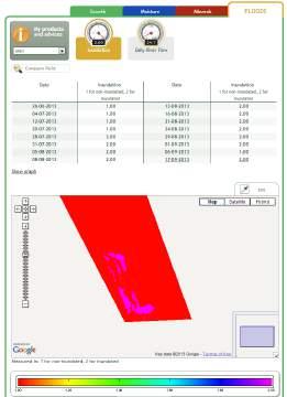
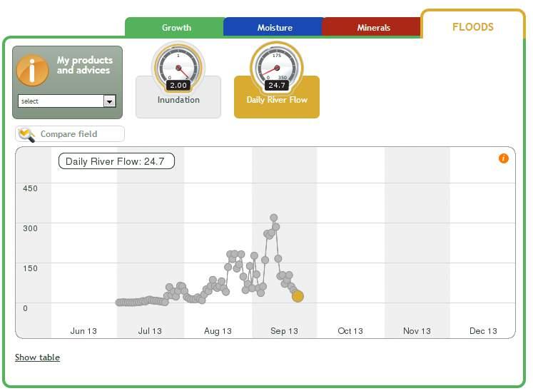
9 REGIONAL FLOOD RISK MAPPING - SA and SEA Maping algorithm based on MODIS data 8-days maps of inundation extent Annual maps of maximum inundation Inter-annual variation of regional flooding extent


10 Concept of Flood Mitigation and Irrigation Improvement Hydrograph for observed and simulated discharge


11 Flood Early Warning for Protection measures Accepted in IAHS Red Book Series (2015) Integrated flood risk management that reduces flood risk while increasing its positive impact is needed Socio-economic aspects Building multi-objective reservoir that reduces flood impact during wet season and used stored water for irrigation purpose during dry season Proper Dam operation and application of basin scale forecasting system Ecosystem Management aspect Re-establishing wetlands in the downstream of the basin area Re-forestation in the upstream areas


12 SOUTH ASIA DROUGHT MONITOR SYSTEM (SA-DMS) First of its kind to establish for entire South Asia using multisource remote sensing observations; Historical drought risk mapping and assessment covering SA countries (2000 Current); IDSI allows better understanding on drought frequency, duration over the 15years; Products are useful tools in drought mitigation studies and in decisionmaking process; 2015 field observations in Jalna, Maharashtra


13 Standardized Precipitation Index South Asia Drought Forecast System To utilize real-time precipitation and air temperature data for drought monitoring in South Asia To evaluate the relationship between drought indices for the selected geographical regions Development of real-time drought monitoring and forecast system for South Asia The monitor successfully captures the meteorological drought of 2015 at the end of the monsoon (JJAS)


14 Urban planner / manager: What type and level of protection is appropriate? Funding Donor: CCAFS

15 MULTIPLE CLIMATE RISKS ASSESSMENT High to Extreme Risk Districts: East and West Nimar, Dhar, Barwani, Ratlam, Mandsaur, Shajapur, Bhopal, Hoshangabad


16 NEAR REAL-TIME FLOOD EMERGENCY RESPONSE MAPPING FOR SRI LANKA
 Rainfall accumulation for the past 36 hrs.")
17 GPM Satellite Measures Extreme Rainfall in Sri Lanka 9 th May 10 th May 11 th May 12 th May 13 th May 14 th May 15 th May 2.30pm Accumulated Daily Rainfall Estimates using Global Precipitation Measurements (GPM) Rainfall accumulation for the past 36 hrs. Districts with rainfall more than 150mm (Ampara - 161mm, Moneragala - 188mm, Badulla -160mm, Nuwara Eliya - 120mm, Kandy - 104mm, Colombo - 107mm) Through Wednesday, widespread rainfall of mm (4-8 inches) of rain will fall across the region.

18 Flood Situation maps in Sri Lanka

19 Near real-time satellite data, GIS and Openstreet data.


20 Operational Flood Management Information Eastern Sudan


21 WetIn mobile app based flood early warning WetIn allows users to monitor rivers and streams in the Niger-Benue river system in Nigeria using satellite altimetry WetIn will be limited to the android operating system devices, for the time being. To provide an alternative to traditional monitoring using radar altimetry and improve model-predicted discharge in the downstream This mobile app aims to give added support to authorities and citizens during this rainy season in Nigeria


, Indian Institute of Technology (IIT)-Gandhinagar, Indian")
22 INDEX-BASED FLOOD INSURANCE IN INDIA TO ENHANCE AGRICULTURE RESILIENCE AND FLOOD PROOFING LIVELIHOODS IBFI Concept Setting up pilot-scale trials to demonstrate that positive verifiable impacts emerge from IBFI in terms of agriculture resilience and improving productivity, and household incomes, locally and at the broader scale Developing tools and strategies that support IBFI development and upscaling, integrated with existing and future flood control measures. Project Period: Pilot Districts : Muzaffarpur, Darbhanga, Samastipur Partners: International Food Policy Research Institute (IFPRI), Indian Institute of Technology (IIT)-Gandhinagar, Indian Institute of Water Management (IIWM-ICAR)*; Agriculture Insurance Corporation of India, MoA; Bajaj Allianz, Insurer, Swiss Reinsurance


23 Assessing flood damages using Drone Mapping flood severity using Unmanned Air Vehicle or Drone in Hanwella town along the Kelani Ganga River Drone with 4 cm spatial resolution deployed at 70 m above ground level at 3.30 pm to map flood damages along the Kelani Ganga river near Hanwella. Most damages noticed in the household than the crop damages Several roads has been disconnected restricted the movement of population as well as rescue operations
24 Conclusions Freely available satellite imagery will improve science and environmentalmonitoring products Governments and the remote-sensing community should now seize the opportunity to develop a unified strategy for DRM. The remote-sensing community must advocate the development and maintenance of data archives and innovative processing methods. Best-practice approaches and standards can be developed by the GEO, a voluntary partnership between governments and international organizations to promote global collaboration around EO, and offshoots such as the IDC. Finally, researchers, policy-makers, non-governmental organizations and land managers need to use and promote more widely the capacity of the satellite data for DRM.
South Asia Drought Monitoring System (SADMS) A Collaborative project by IWMI, GWP and WMO under Integrated Drought Management Programme
 A Collaborative project by IWMI, GWP and WMO under Integrated Drought Management Programme") South Asia Drought Monitoring System (SADMS) A Collaborative project by IWMI, GWP and WMO under Integrated Drought Management Programme NDVI 2002 NDVI 2003 Giriraj Amarnath, Niranga Alahacoon, Peejush
South Asia Drought Monitoring System (SADMS) A Collaborative project by IWMI, GWP and WMO under Integrated Drought Management Programme NDVI 2002 NDVI 2003 Giriraj Amarnath, Niranga Alahacoon, Peejush
DROUGHT MONITORING AND ASSESSMENT IN SOUTH ASIA
 DROUGHT MONITORING AND ASSESSMENT IN SOUTH ASIA Giriraj Amarnath International Water Management Institute (IWMI), Sri Lanka 06 September 2017 AC Meeting of the IDMP, Geneva, Switzerland SOUTH ASIA DROUGHT
MAPPING, MODELING AND MANAGING FLOOD RISKS
 MAPPING, MODELING AND MANAGING FLOOD RISKS Giriraj Amarnath International Water Management Institute (IWMI), Colombo, Sri Lanka JPTM for Sentinel Asia STEP3 (JPTM 2013), 27 28 Nov 2013, Bangkok, Thailand
A WATER-SECURE WORLD
 WWW.IWMI.ORG A WATER-SECURE WORLD IWMI A WATER-SECURE WORLD COVER PHOTO JOE RONZIO / IWMI 2 THE INTERNATIONAL WATER MANAGEMENT INSTITUTE (IWMI) OPERATES AT THE INTERFACE OF RESEARCH AND DEVELOPMENT TO
Summary of the socio-economic impact of Copernicus in the EU
 Summary of the socio-economic impact of Copernicus in the EU ESA Since the entry into service of Copernicus first satellite, Sentinel-1A, in 2014, the impacts of the programme are witnessed beyond the
What is SERVIR? SERVIR-Mekong : Geospatial Data and Analysis for. Better Decision Making in the Lower Mekong Region
 SERVIR-Mekong : Geospatial Data and Analysis for Better Decision Making in the Lower Mekong Region 29 October 2015 What is SERVIR? (Sistema Regional de Visualización y Monitoreo) Partnership between USAID
Mainstreaming Disaster Risk Reduction in Agriculture
 Mainstreaming Disaster Risk Reduction in Agriculture Among the various sectors of development, agriculture is at higher risk because of the inherent vulnerability Who pays for disaster losses? Poor pays
Managing Water Variability: Floods and Droughts
 7 Managing Water Variability: Floods and Droughts 33 Managing Water Variability: Floods and Droughts Lead author: Vladimir Smakhtin With contributions from: Paul Pavelic, Giriraj Amarnath, Matthew McCartney,
IWMI in Action. A water-secure world
 IWMI in Action A water-secure world Our focus on global challenges In a world of rapid social, economic and environmental change, water scarcity and declining water quality pose serious and undeniable
Water Management and Hydrological Research Issues in Lower Indus Basin
 Water Management and Hydrological Research Issues in Lower Indus Basin Azeem Shah Regional Researcher: Governance of Water Institutions IWMI Pakistan Nitasha Nair Senior Communications Officer, IWMI AGENDA
SITE PRIORITIZATION FOR IBFI
 SITE PRIORITIZATION FOR IBFI Rajesh K Pandey, Giriraj Amarnath, Niranga Alahacoon, Karthikeyan Matheswaran IWMI, Colombo Inception Workshop on Index Based Flood Insurance (IBFI) for Agriculture Risk Management
Futures and Foresight Activities in WLE ARM State of Foresight in the CGIAR
 Futures and Foresight Activities in WLE IWMI ARM - 2018 State of Foresight in the CGIAR University of Aberdeen 9-10 May 2018 Presented by: David Wiberg, IWMI water-secure world world AA water-secure www.iwmi.org
<<VDO Part 1 here>> Dr. Jingjai Hanchanlash, Executive Director of Asian Disaster Preparedness Center Distinguished guests Ladies and Gentlemen
 SCIENTIFIC INNOVATIONS AND PRIVATE SECTOR FOR CLIMATE RESILIENCE SPEECH DELIVERED BY DR. PICHET DURONGKAVEROJ, AT THE ASIAN BUSINESS FORUM ON RISK REDUCTION AND RESILIENCE BUILDING Dusit Thani Hotel, Bangkok,
a water-secure world IWMI in sri lanka
 a water-secure world IWMI in sri lanka IWMI what we do Cover A farmer adjusts a sprinkler in Kalpitiya. Saaliya Thilakartne/IWMI. 2 OUR role The International Water Management Institute (IWMI) and partners
The Future of Water in Asia
 The Future of Water in Asia The Future of Water 3 rd Karachi International Water Conference 2017 Dr. Claudia Sadoff, Director General International Water Management Institute Great global concern over
Connecting Space to Village in the Hindu Kush Himalaya. Objectives
 Connecting Space to Village in the Hindu Kush Himalaya SERVIR connects space to village by helping developing countries use satellite data to address challenges in food security, water resources, weather
The United Nations Office for Outer Space Affairs: its role and the support it provides
 The United Nations Office for Outer Space Affairs: its role and the support it provides SIMONETTA DI PIPPO, DIRECTOR United Nations Office for Outer Space Affairs United Nations Office at Vienna www.unoosa.org
Priyanka Dissanayake Regional Coordinator GWP South Asia (GWP SAS) September 4, 2013 Kathmandu, Nepal
 September 4, 2013 Kathmandu, Nepal") Priyanka Dissanayake Regional Coordinator GWP South Asia (GWP SAS) September 4, 2013 Kathmandu, Nepal South Asia spreads over about 4% of the World s land area Possesses about 4.5% of the water resources
Priyanka Dissanayake Regional Coordinator GWP South Asia (GWP SAS) September 4, 2013 Kathmandu, Nepal South Asia spreads over about 4% of the World s land area Possesses about 4.5% of the water resources
Climate Change in Nepal: Domestic and Regional Perspectives
 Climate Change in Nepal: Domestic and Regional Perspectives Smriti Dahal, PhD Senior Programme Officer 17 October, 2014 Presentation Outline Nepal s vulnerability to climate change Impacts of climate change
South Asia Drought Monitoring System (SADMS) A Joint Collaborative project by IWMI, GWP and WMO under Integrated Drought Management Programme
 A Joint Collaborative project by IWMI, GWP and WMO under Integrated Drought Management Programme") South Asia Drought Monitoring System (SADMS) A Joint Collaborative project by IWMI, GWP and WMO under Integrated Drought Management Programme Giriraj Amarnath, Niranga Alahacoon, Peejush Pani, Vladimir
South Asia Drought Monitoring System (SADMS) A Joint Collaborative project by IWMI, GWP and WMO under Integrated Drought Management Programme Giriraj Amarnath, Niranga Alahacoon, Peejush Pani, Vladimir
NASA s Contribution to Water Research, Applications, and Capacity Building in Africa
 NASA s Contribution to Water Research, Applications, and Capacity Building in Africa Nancy D. Searby 1, David Toll 2, Rick Lawford 3, 1 NASA HQ Earth Sciences Division Applied Sciences Program 2 NASA GSFC
BUILDING EXPOSURE MAPS OF URBAN INFRASTRUCTURE AND CROP FIELDS IN THE MEKONG RIVER BASIN
 BUILDING EXPOSURE MAPS OF URBAN INFRASTRUCTURE AND CROP FIELDS IN THE MEKONG RIVER BASIN E. Haas (1), J. Weichselbaum (1), U. Gangkofner (1), J. Militzer (1), A. Walli (1) (1) GeoVille, Sparkassenplatz
CGIAR Research Program on Water, Land and Ecosystems: Use of remote sensing and GIS tools in the irrigation commands to assist planning and management
 CGIAR Research Program on Water, Land and Ecosystems: Use of remote sensing and GIS tools in the irrigation commands to assist planning and management Summary Remote sensing (RS) and geographic information
Cause damage to - Negatively affect - Affect all the primary resources e.g. -
 Affect all the primary resources e.g. - Land Water Biomass Air As a consequence of such Natural Hazard, all developmental processes get impeded Cause damage to - Agriculture / Fisheries, etc. Population
Climate change Adaptation in South Asia
 Climate change Adaptation in South Asia SREEJA NAIR TERI South Asia Climate Change Focal Points and Experts Consultation Meeting, Thimphu, 16-17 November 2011 Global mean temperatures rising faster with
DELIVERING ON AIR QUALITY, CLIMATE CHANGE AND HEALTH
 DELIVERING ON AIR QUALITY, CLIMATE CHANGE AND HEALTH A World Health Organization, UN Environment, World Meteorological Organization partnership, supported by the Climate and Clean Air Coalition Air Quality
Earth observations for water resource management: Current practice and examples
 Earth observations for water resource management: Current practice and examples NEW OPPORTUNITIES IN SATELLITE AND AIRBORNE REMOTE SENSING: Hydrological and Environmental Applications DTU Environment Lyngby
THE GLOBAL WATER CYCLE THEME WITHIN THE INTEGRATED GLOBAL OBSERVING STRATEGY FRAMEWORK
 THE GLOBAL WATER CYCLE THEME WITHIN THE INTEGRATED GLOBAL OBSERVING STRATEGY FRAMEWORK RICK LAWFORD & JOSEF ASCHBACHER WATER FOR THE WORLD: SPACE SOLUTIONS FOR WATER MANAGEMENT SEPTEMBER 13, 2004 GRAZ,
OXFAM IN ASIA. Asia Regional Water Governance Program. FAIR SHARing OF NATURAL RESOURCES
 OXFAM IN ASIA Asia Regional Water Governance Program FAIR SHARing OF NATURAL RESOURCES Nepal Bhutan India Brahmaputra Ganges meghna (gbm) river basin Over 650 Bangladesh Bay of Bengal million population
EO4SD EARTH OBSERVATION FOR SUSTAINABLE DEVELOPMENT
 LARGE-SCALE EXPLOITATION OF SATELLITE DATA IN SUPPORT OF INTERNATIONAL DEVELOPMENT EO4SD EARTH OBSERVATION FOR SUSTAINABLE DEVELOPMENT Agriculture and Rural Development Bolivia and Paraguay Agriculture
EO Information Services in support of
 EO Information Services in support of Building Exposure Maps of Urban Infrastructure and Crop Fields in the Mekong River Basin Christian Hoffmann, GeoVille group World Bank HQ, Washington DC Date : 11
Asia-Pacific Disaster Resilience Network for Coherence of the Sendai Framework and SDGs
 Asia-Pacific Disaster Resilience Network for Coherence of the Sendai Framework and SDGs REGIONAL COOPERATION ENABLES ACCESS TO TRANSFORMATIVE TOOLS AND APPROACHES Poverty widespread in Ganges- Brahmaputra-Meghna
Engr. Md. Waji Ullah Executive Director, CEGIS and Member, JRC
 Operationalization of South Asia Drought Management and Monitoring System (SADMS) Engr. Md. Waji Ullah Executive Director, CEGIS and Member, JRC Outline Drought Background and Events in Bangladesh Driving
GFDRR on Hydromet US$30. $2 billion
 GFDRR on Hydromet Launched in 2011, the GFDRR Hydromet Program works closely with the World Meteorological Organization and other partners to help countries modernize their weather, climate, and hydrological
Development of an Integrated Information System for Flood Control and Water Management in Western Province
 Development of an Integrated Information System for Flood Control and Water Management in Western Province - A Prototype for IFI Demonstration project Srikantha Herath Ministry of Megapolis and Western
The Global Climate Observing System and Sustainable Development An Action Plan for Africa. William Westermeyer GCOS Secretariat
 The Global Climate Observing System and Sustainable Development An Action Plan for Africa William Westermeyer GCOS Secretariat GCOS Regional Workshop Programme.to identify the priority capacity-building
Integrated Drought Management Programme
 Click the icon to add a photo Integrated Drought Management Programme Guidelines for Drought Management Plans Drought and Water Scarcity Bratislava, 17-18 May 2016 Richard Müller Drought Management drought
Water targets and indicators of the the SDGs Peter Koefoed Bjornsen Director of UNEP-DHI Partnership Centre on Water and Environment
 UNEP-DHI Water Webinar series Approaching the SDGs through Innovation in Water Management Water targets and indicators of the the SDGs Peter Koefoed Bjornsen Director of UNEP-DHI Partnership Centre on
Managing Extreme Floods in Pakistan
 Managing Extreme Floods in Pakistan Shahbaz Khan Chief, Water and Sustainable Development UNESCO Division of Water Sciences 2 Monsoon 2010 : Extreme Rainfall - Flood INTERACTION L Monsoon 2010 (July) Interaction
Climate+Change in the Hindu Kush Himalaya
 Climate+Change in the Hindu Kush Himalaya Implications for Irrigation David Molden International Centre for Integrated Mountain Development The Hindu Kush Himalaya Global asset for food, energy, water,
WATER CYCLE VARIABLES
 WATER CYCLE VARIABLES ISSUE: THE PROPOSAL FOR A WORKSHOP FOR THE EVALUATION OF HIGH RESOLUTION GLOBAL PRECIPITATION PRODUCTS HAS NOT RECEIVED FULL FINANCIAL SUPPORT. CONCLUSION: THE ALTERNATIVES PROPOSED
Role of space based information in light of the Post 2015 Framework for Disaster Risk Reduction: UN-SPIDER Interventions
 Role of space based information in light of the Post 2015 Framework for Disaster Risk Reduction: UN-SPIDER Interventions Shirish Ravan UN-SPIDER Beijing Office UN Office for Outer Space Affairs Context
The GEO Global Agricultural Monitoring (GEOGLAM) Initiative
 Initiative") The GEO Global Agricultural Monitoring (GEOGLAM) Initiative Chris Justice GEOGLAM Global Co-Lead The Center for Agricultural Monitoring Research, Department of Geographical Sciences, GEOGLAM Launched by
The GEO Global Agricultural Monitoring (GEOGLAM) Initiative Chris Justice GEOGLAM Global Co-Lead The Center for Agricultural Monitoring Research, Department of Geographical Sciences, GEOGLAM Launched by
FLOOD Analysis And Development of Groundwater Recharge and Discharge Estimate Maps using GIS
 FLOOD Analysis And Development of Groundwater Recharge and Discharge Estimate Maps using GIS Dr. Ghulam Nabi Assistant Professor Center of Excellence in Water Resources Engineering, g University of Engineering
GEOINFORMATION TECHOLOGY FOR HARZAD MONITORING AND DISATER RISK REDUCTION. Hussein O. Farah, PhD
 GEOINFORMATION TECHOLOGY FOR HARZAD MONITORING AND DISATER RISK REDUCTION Hussein O. Farah, PhD Regional Centre for Mapping of Resources for Development Kasarani Road, P.O.Box 632-00618 Nairobi, Kenya
Hydrological Aspects of Drought
 World Meteorological Organization SEOUL, REPUBLIC OF KOREA 25-27 October, 2016 REGIONAL ASSOCIATION II WORKING GROUP ON HYDROLOGICAL SERVICES Hydrological Aspects of Drought Irina Dergacheva NIGMI of Uzhydromet
IMPACT OF CLIMATE CHANGE ON CITIES
 IMPACT OF CLIMATE CHANGE ON CITIES TRAINING PROGRAM ON URBAN CLIMATE CHANGE RESILIENCE 18-19 May 2015 Pune Riya Rahiman Research Associate, Sustainable Habitat Division The Energy and Resources Institute
DEVELOPMENT OF A DECISION SUPPORT SYSTEM FOR NATURAL DAMAGE ASSESSMENT BASED ON REMOTE SENSING AND BIO-PHYSICAL MODELS
 DEVELOPMENT OF A DECISION SUPPORT SYSTEM FOR NATURAL DAMAGE ASSESSMENT BASED ON REMOTE SENSING AND BIO-PHYSICAL MODELS M.A. Sharifi a*, W.G.M. Bastiaanssen b, S.J. Zwart b a ITC, P.O. Box 6, 7500 AA, Enschede,
1. GEO Related Observing Systems
 Australian GEO Report 1. GEO Related Observing Systems 2. Innovative Use of Earth Observations Michael Coughlan Chief Climatologist Australian Bureau of Meteorology GEO Related Australian Systems Observing
Capabilities Statement
 Capabilities Statement Welcome! People benefit from a multitude of resources and processes supplied by natural resources and ecosystems. These benefits include water supplies suitable for supporting economic
MODULE 8 LECTURE NOTES 5 REMOTE SENSING APPLICATIONS IN DROUGHT ASSESSMENT
 MODULE 8 LECTURE NOTES 5 REMOTE SENSING APPLICATIONS IN DROUGHT ASSESSMENT 1. Introduction Drought is a phenomenon of long-term moisture deficiency. It may be meteorological, agricultural or hydrologic
Building climate resilience
 Public Disclosure Authorized Public Disclosure Authorized Public Disclosure Authorized THE NILE STORY BRIEFING NOTE 3 102249 Building climate resilience Climate change is a critical issue facing the countries
Understanding adaptation and its current. Arjuna Srinidhi. New Delhi, 6/11/2014
 Climate Change Adaptation Understanding adaptation and its current challenges An overview Arjuna Srinidhi New Delhi, 6/11/2014 not just adaptation What is adaptation? IPCC: The process of adjustment to
Role of Climate Smart Agriculture in achieving Land Degradation Neutrality in Sri Lanka. Champika S Kariyawasam
 Role of Climate Smart Agriculture in achieving Land Degradation Neutrality in Sri Lanka Champika S Kariyawasam Land Degradation Neutrality- Global Developments 2012 - UN Conference on Sustainable Development
Drought Indicators for the SADC
 Drought Indicators for the SADC Bruce Eady DHI-SA Annual Conference Coping with Drought: Adaptions to Water Stress in the Face of Climate Change Agenda Introduction Satellite Data Drought and Flood Portal
Climate-related risks that are most relevant to African context
 UNFCCC expert meeting on a range of approaches to address loss and damages associated with the adverse effects of climate change, including impacts related to extreme weather and slow onset events Climate-related
What we are looking for through utilizing the global earth observation. 14 January 2012 Japan International Cooperation Agency (JICA) Yusuke AMANO
 Yusuke AMANO") What we are looking for through utilizing the global earth observation 14 January 2012 Japan International Cooperation Agency (JICA) Yusuke AMANO 1 Outline To clarify what sort of data are to be monitored
What we are looking for through utilizing the global earth observation 14 January 2012 Japan International Cooperation Agency (JICA) Yusuke AMANO 1 Outline To clarify what sort of data are to be monitored
Flash Flood Forecasting. WORLD METEOROLOGICAL ORGANIZATION COMMISSION FOR BASIC SYSTEMS SWFDP Steering group meeting Feb 2012
 Flash Flood Forecasting Contents 1. Background 2. Challenges 3. Opportunities 4. Way Forward 1. Background; Angola Burundi Congo Ethiopia Kenya Rwanda Tanzania Uganda River Flood 1 1 2 3 2 Flash floods
EU-Africa collaboration on Space applications for Africa
 EU-Africa collaboration on Space applications for Africa Background Maputo Declaration: African policy makers request EC to open its GMES initiative to Africa (Oct 2006) Build on existing EO activities
Integrated Water Resource Services
 Integrated Water Resource Services Water: when scarce, a precious resource when excessive, a source of many hazards 1 Gary Carter NOAA Hydrology Program Manager Interagency Meeting on Water Resources May
: ENVIRONMENTAL SCIENCE AND DISASTER MANAGEMENT COURSE CODE : 3001 COURSE CATEGORY : P PERIODS/ WEEK : 3 PERIODS/ SEMESTER : 45 CREDIT : 3
 COURSE TITLE : ENVIRONMENTAL SCIENCE AND DISASTER MANAGEMENT COURSE CODE : 3001 COURSE CATEGORY : P PERIODS/ WEEK : 3 PERIODS/ SEMESTER : 45 CREDIT : 3 TIME SCHEDULE MODULE TOPICS PERIODS 1 Renewable and
Climate Change Adaptation and Disaster Risk Reduction: The Case of Ghana
 Climate Change Adaptation and Disaster Risk Reduction: The Case of Ghana Presented by Ruby Sandhu-Rojon UN Resident Coordinator and UNDP Resident Representative Ghana May 11, 2011 1 Ghana: Climate Change
Pooling the data into intersectoral governance for incountry
 Using Big Data and Earth Observations for SDG 6 monitoring World Water Week 2018 August 29 Stockholm, Sweden Pooling the data into intersectoral governance for incountry implementation Christian Tottrup,
National Climate Outlook Forum (NCOF): scaling down RCOF outlooks for decision making at national scale
: scaling down RCOF outlooks for decision making at national scale") WMO WORKSHOP ON GLOBAL REVIEW OF REGIONAL CLIMATE OUTLOOK FORUMS 5-7 September, 2017 Guayaquil, Ecuador National Climate Outlook Forum (NCOF): scaling down RCOF outlooks for decision making at national
WMO WORKSHOP ON GLOBAL REVIEW OF REGIONAL CLIMATE OUTLOOK FORUMS 5-7 September, 2017 Guayaquil, Ecuador National Climate Outlook Forum (NCOF): scaling down RCOF outlooks for decision making at national
EO4SDGs and Disaster Risk Reduction Virginia Burkett Chief Scientist, USGS Climate and Land Use Change
 EO4SDGs and Disaster Risk Reduction Virginia Burkett Chief Scientist, USGS Climate and Land Use Change U.S. Department of the Interior U.S. Geological Survey United Nations (2015): Sendai Framework for
DRAFT GEO Report on Progress
 GROUP ON EARTH OBSERVATIONS GEO Ministerial Summit Earth Observations for Sustainable Growth and Development 19 September 2007 Task Force 2 Version 6 [Note: the illustration above is used as a placeholder
FRAMEWORK FOR ECOSYSTEM-BASED ADAPTATION(EBA) AT SUBNATIONAL LEVEL FOR THE GMS- IMPLEMENTATION AND MAINSTREAMING RAJI DHITAL
 AT SUBNATIONAL LEVEL FOR THE GMS- IMPLEMENTATION AND MAINSTREAMING RAJI DHITAL") FRAMEWORK FOR ECOSYSTEM-BASED ADAPTATION(EBA) AT SUBNATIONAL LEVEL FOR THE GMS- IMPLEMENTATION AND MAINSTREAMING RAJI DHITAL VULNERABILITY TO CLIMATE CHANGE IN THE GMS Remarkable increase in the frequency
FRAMEWORK FOR ECOSYSTEM-BASED ADAPTATION(EBA) AT SUBNATIONAL LEVEL FOR THE GMS- IMPLEMENTATION AND MAINSTREAMING RAJI DHITAL VULNERABILITY TO CLIMATE CHANGE IN THE GMS Remarkable increase in the frequency
Assessing agricultural vulnerability to climate change in Sri Lanka
 Sri Lanka Journal of Food and Agriculture (2015) Niranjan et al. 1(1): 85-92 ISSN 2424-6913 Research Paper Assessing agricultural vulnerability to climate change in Sri Lanka F. Niranjan 1, N.P.C. Uddika
Climate Change Research, Education and Outreach Activities at AIT
 Climate Change Research, Education and Outreach Activities at AIT The Second International Conference on Sustainability Science in Asia (ICSS-Asia) March 2-4, 2011, Hanoi, Vietnam Dr. Sangam Shrestha Assistant
IMPACT OF HYDROELECTRIC DEVELOPMENT OF THE UPPER REACHES OF IRRAWADDY RIVER ON THE LOWER REACHES
 IMPACT OF HYDROELECTRIC DEVELOPMENT OF THE UPPER REACHES OF IRRAWADDY RIVER ON THE LOWER REACHES Reporter: Ma Jianwei China Institute of Water Resource and Hydropower Research 22 Feb 2018 http://www.iwhr.com/iwhr-english/index.htm
Disaster Early Warning and Response Activities at RCMRD Tesfaye Korme (Ph.D), Regional Centre for Mapping of Resources for Development
, Regional Centre for Mapping of Resources for Development") Satellite Earth Observation & Disaster Risks Disaster Early Warning and Response Activities at RCMRD Tesfaye Korme (Ph.D), Regional Centre for Mapping of Resources for Development RCMRD and its member
Satellite Earth Observation & Disaster Risks Disaster Early Warning and Response Activities at RCMRD Tesfaye Korme (Ph.D), Regional Centre for Mapping of Resources for Development RCMRD and its member
Prepared by: Hopeton Peterson & Doneika Simms of the The Planning Institute of Jamaica (PIOJ) May 10, 2012
 May 10, 2012") Prepared by: Hopeton Peterson & Doneika Simms of the The Planning Institute of Jamaica (PIOJ) May 10, 2012 Objectives Highlight expected climate risks and discuss how they will affect Jamaica s rural areas
Prepared by: Hopeton Peterson & Doneika Simms of the The Planning Institute of Jamaica (PIOJ) May 10, 2012 Objectives Highlight expected climate risks and discuss how they will affect Jamaica s rural areas
Managing Drought Risk in a Changing Climate: The Role of National Drought Policy
 Managing Drought Risk in a Changing Climate: The Role of National Drought Policy Dr. Donald A. Wilhite School of Natural Resources University of Nebraska-Lincoln National Drought Management Policy Workshop,
4. Present Activities and Roles
 4. Present Activities and Roles The present missions, authorities, activities and roles of the various agencies involved with flood protection, floodplain management and flood-damage reduction are identified
Monitoring Drought Across Many Scales
 Purdue University Purdue e-pubs 2011 Symposium on Data-Driven Approaches to Droughts Drought Research Initiative Network 6-21-2011 Monitoring Drought Across Many Scales Chris Funk USGS, cfunk@usgs.gov
Applications for. Management. Agricultural Risk Management Team. The World Bank
 Geospatial Technology Applications for Agricultural Risk Management Agricultural Risk Management Team Agriculture and Environmental Services Department The World Bank Agricultural Risks : Cross Cutting
Earth Observation in support for project identification/preparation
 Asian Water Forum Oct. 5th 2018 Asian Development Bank Manila, Philippines Earth Observation in support for project identification/preparation Christian Tottrup, DHI GRAS EO4SD -> Background Water plays
Integrated Water Resource Services
 Integrated Water Resource Services Jawed Hameedi NOAA National Ocean Service NJ WMCC -- May 30, 2007 [POC for IWRS: Gary Carter, NWS] Challenge: National Water Resource Impacts Economic Prosperity (energy,
Asia-RiCE 2016 Implementation Report
 Asia-RiCE 2016 Implementation Report Asia-RiCE has been organised to develop the rice crop estimation and monitoring component for the GEO Global Agricultural Monitoring (GEOGLAM) initiative. GEOGLAM aims
Summary Report of the Need Assessment Survey on the Development of South Asian Drought Monitoring System (SA DMS)
") Drought Monitoring ing System for South Asia Summary Report of the Need Assessment Survey on the Development of South Asian Drought Monitoring System (SA DMS) Compiled by Global Water Partnership, South
Drought Monitoring ing System for South Asia Summary Report of the Need Assessment Survey on the Development of South Asian Drought Monitoring System (SA DMS) Compiled by Global Water Partnership, South
SADMS DROUGHT BULLETIN
 SADMS DROUGHT BULLETIN Agriculture drought condition for South Asia 28 Sep 2018 ISSUE 10 Current Rainfall condition in reference to historical rainfall 14 Sep - 21 Sep, 2018 South Asia Drought Monitoring
Urban Floods Challenges
 Urban Floods Challenges Mr. Dang Quang Tinh Director Department of Dike Management and Flood and Storm Control, Viet Nam Srikantha Herath Environment and Sustainable Development United Nations University
Climate Change Mitigation and Adaptation Options: The Nigerian Experience
 Climate Change Mitigation and Adaptation Options: The Nigerian Experience Prof. Ayobami T. Salami Head, Space Application and Environmental Laboratory (SPAEL), & Coordinator, Climate Change Unit, Institute
OBJECTIVES & ACTIVITIES OF KSNDMC
 OBJECTIVES & ACTIVITIES OF KSNDMC Disaster Management heavily depends on inputs from Science and Technology. KSNDMC has been serving as a common platform to the various response players in the field of
JICA efforts in supporting adaptation to climate change
 Twenties Asia-Pacific Seminar on Climate Change Promoting Strategic Development of Resilient Asia-Pacific JICA efforts in supporting adaptation to climate change March 15, 2012 Hiroshi ENOMOTO Deputy Director,
Vladimir Tsirkunov and Makoto Suwa Hydromet Program Global Facility For Disaster Reduction and Recovery The World Bank
 Photo by NASA WB/GFDRR Hydromet Program Towards effective partnerships in support of global hydromet services Vladimir Tsirkunov and Makoto Suwa Hydromet Program Global Facility For Disaster Reduction
Flood Hazard Mapping Project in Huong River Basin of Thua Thien Hue Province
 Proposal Report on Flood Hazard Mapping Project in Huong River Basin of Thua Thien Hue Province Prepared by PHAM Viet Tien Center for Application of Hydro-meteorological Technology (belong to National
Presentation outline Introduction Condition in Indonesia Recent Big Flood in Bengawan Solo and Brantas River Basins Watershed Degradation and Sediment
 Presentation outline Introduction Condition in Indonesia Recent Big Flood in Bengawan Solo and Brantas River Basins Watershed Degradation and Sedimentation Problems in the Basins Losses and Damages Due
AIMS pilot project. Monitoring the rehabilitation of degraded landscapes from Food Assistance for Assets programmes with satellite imagery
 Fighting Hunger Worldwide AIMS pilot project Monitoring the rehabilitation of degraded landscapes from Food Assistance for Assets programmes with satellite imagery September 2017 BEFORE road construction
AMATHOLE DISTRICT MUNICIPALITY CASE STUDY 2018
 AMATHOLE DISTRICT MUNICIPALITY CASE STUDY 2018 LOCAL ACTION FOR BIODIVERSITY: WETLANDS SOUTH AFRICA Focused wetland prioritisation in Amathole District Municipality Planning for wetland rehabilitation
TOPIC: The Challenge of Natural Hazards Climate change section Slide 1: Evidence for climate change
 Slide 1: Evidence for climate change What is climate change? AQA definition: A long-term change in the earth's climate, normally associated with temperature change. The Earth is 4.5 billion years old.
The Development of Hydrological Services
 The Development of Hydrological Services Bruce Stewart President of the WMO Commission for Hydrology Abstract The primary objective of any Hydrological Service (HS) is the management of water resources
Mainstreaming Nature-based solutions in World Bank Flood Risk Reduction Investments
 Mainstreaming Nature-based solutions in World Bank Flood Risk Reduction Investments Denis Jordy, Lead Disaster Risk Management Specialist, GFDRR Flood Risk: What is at stake? Floods Storm Floods - most
Madhya Pradesh Bhoj (Open) University, Bhopal
 University, Bhopal") Subject: Understanding Natural Disaster Maximum Marks: 30 2& nksuksa l=h; iz'u i= fo ofo ky; }kjkiznk; l=h; mrrjiqflrdkvksa esa gy djuk vfuok;z gsa - ------------------------ Q.1 Discuss the different
Subject: Understanding Natural Disaster Maximum Marks: 30 2& nksuksa l=h; iz'u i= fo ofo ky; }kjkiznk; l=h; mrrjiqflrdkvksa esa gy djuk vfuok;z gsa - ------------------------ Q.1 Discuss the different
Overall Planning and Preparation Process. BAU Business as Usual NAMA Nationally Appropriate Mitigation Actions
 Tanzania Acknowledgments 2016 International Bank for Reconstruction and Development/The World Bank 1818 H Street NW Washington DC 20433, U.S.A. Internet: www.worldbank.org Introduction In response to a
Future Climate Observation Activities of ESA
 Future Climate Observation Activities of ESA GCOS Conference 2016 Amsterdam, 2 March 2016 Prof. Volker Liebig, ESA Director of Earth Observation Programmes COP-21 Global average temperature increase to
SPACE TECHNOLOGY FOR FLOOD WATER HARVESTING FOR IRRIGATION AND OTHER USES
 SPACE TECHNOLOGY FOR FLOOD WATER HARVESTING FOR IRRIGATION AND OTHER USES Integrated Flood Water Harvesting For Irrigation and Multipurpose Use for Community Resilience and Zero Emission in 3 Districts
Investigating the Impact of Climate Change on Flooding in the Sittaung River Basin, Myanmar
 Investigating the Impact of Climate Change on Flooding in the Sittaung River Basin, Myanmar Su Su Kyi * MEE1673 Supervisor: Assoc. Prof. Mohamed Rasmy** Prof. Toshihiro Koike** Dr. Duminda Perera** ABSTRACT
Mekong Climate Change and Adaptation Initiative and the Mekong River Commission
 The real threat: climate change impacts in Lower Mekong Basin Mekong Climate Change and Adaptation Initiative and the Mekong River Commission By Jeremy Bird Chief Executive Officer Mekong River Commission