Automated Information Management Tools to Support Growth Management and Transportation Analyses. Allen Ibaugh, Space Imaging Simone Babb, FDOT
|
|
|
- Jeffery Bond
- 5 years ago
- Views:
Transcription


1 Automated Information Management Tools to Support Growth Management and Transportation Analyses Allen Ibaugh, Space Imaging Simone Babb, FDOT


2 Our TAIMS (Transportation Automated Information Management System) website currently used by District 5 of Florida s Dept of Transportation uses database design and systems integration of over 80 GIS layers from various sources in multiple formats. Design and development of central repository to store spatial and attribute data with access via a browserbased interface for transportation planning and analysis. TAIMS Website


3 Design and development of a spatial data clearinghouse for state, regional, and local government data sharing. Database design to facilitate multiple scales and levels of GIS data to support regional and local level analysis. Conversion of spatial and attribute data to fit statewide and regional applications. CFGIS Website


4 FDOT Interactive For Florida s Department of Transportation, Space Imaging Orlando combines its asset management and multimedia capabilities in developing websites and interactive CD-ROMs that include graphics and video elements.
5 TAIMS Transportation Automated Information Management System
6 Purpose of TAIMS ACCESS information that was previously difficult to retrieve Develop a planning analysis tool that allows users to COMPARE datasets Simplify and AUTOMATE routine data-intensive tasks while improving their accuracy and quality COORDINATE data sharing between the Planning office and other sections throughout the district
7 Core Datasets Roadway Characteristics Inventory Work Program Database BaseMap Information
8 Other Datasets Level of Service Development Review Information Access Management Adopted Models Public Transportation Data Design Traffic Other Local Data Permits / Maintenance Status of Construction List/CST

9 System Design Front Page Design

10 System Design TAIMS currently consists of 10 modules Transportation Modeling Design Traffic SCE/ETDM Work Program Growth Management Level of Service Environmental Administration Public Transportation RCI

11 Data Outputs Each Module contains the following: Forms allows user access to data tables for input or changes Queries extracts specific information Reports organizes and displays data Maps graphically depicts data Links sends the user to an external site Multi-media includes photos, video etc. Finished Products includes ready-to-print maps, reports Search searches based on information entered
12 MODULE EXAMPLE (Growth Management)

13 Module: Growth Mgmt
14 Module: Growth Mgmt Forms

15 Module: Growth Mgmt Forms

16 Module: Growth Mgmt Queries

17 Module: Growth Mgmt Queries

18 Example QUERY continued DRI MAP LOS TABLE LOS MAP CONSTR. TABLE CONSTR. MAP W.P. TABLE W.P. MAP LAND USE TABLE LAND USE MAP


19 Example REPORT -TIP

20 Module: Growth Mgmt Maps

21 Module: Design Traffic Maps
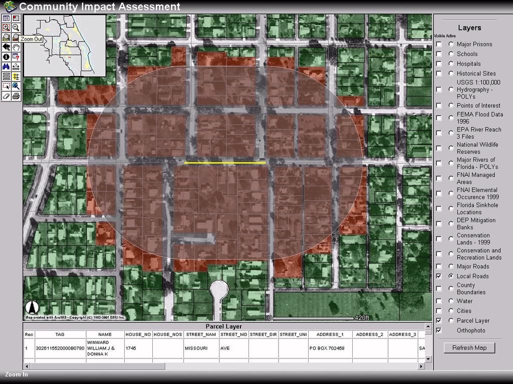
22 Additional Functionality


23 Links

24 Finished Products


25 Finished Products


26 Example Finished Products Constrained Facilities Existing/ Future LOS Park N Ride Facilities Work Program

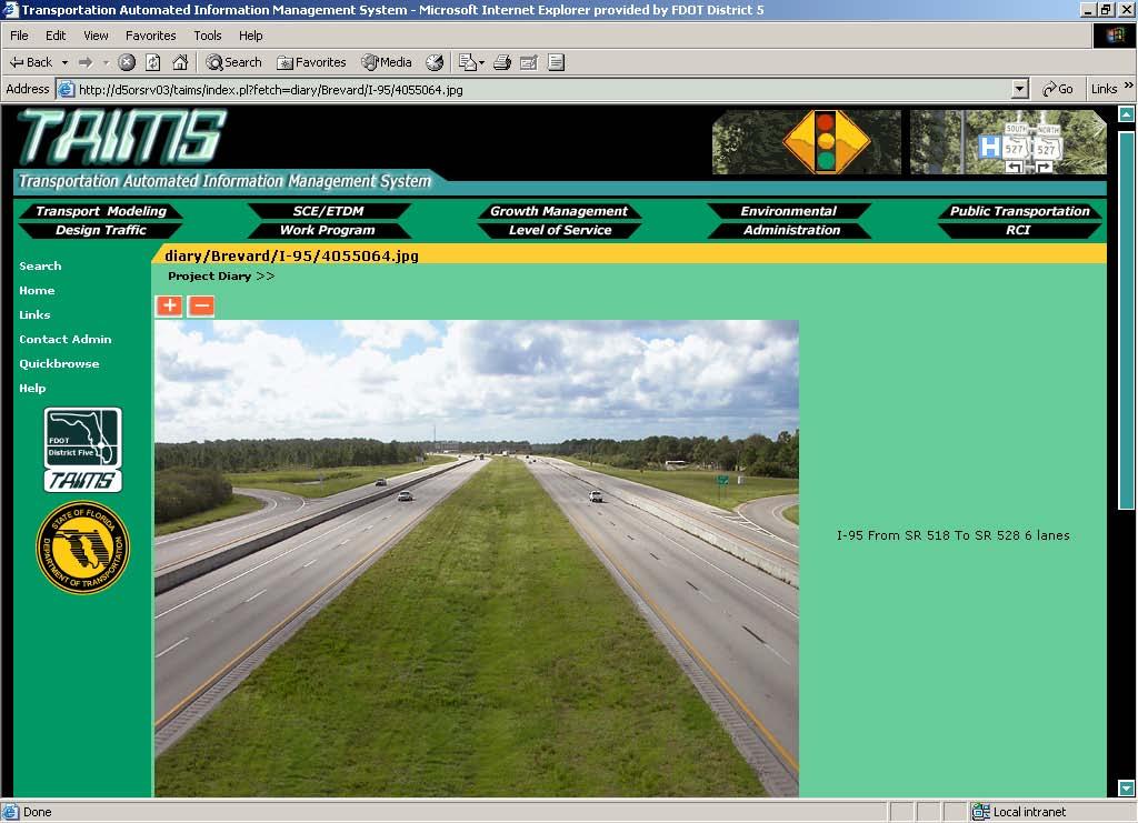

27 Project Diary


28 Work Program & RCI Automation Tool

29 Mapping/Buffers

30 Mapping/Buffers, Continued
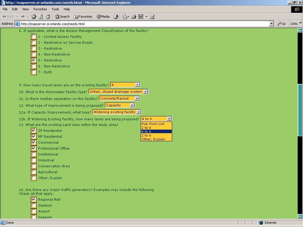
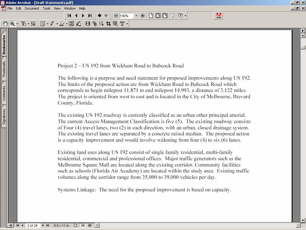
31 Transportation Automated Information System TAIMS SCE Module Automated Community Profile Reports Automated Purpose and Need Statements

32


33
34 TAIMS SCE Module Automated Purpose and Need Statements

35
36

37
38


39 Model Data

40 Community Level Data Parcel Layer

41 Zoning Information
42 CFGIS - Implementation Creation of a regional GIS users group covering a 10 county area in Central Florida Establishment of a data clearinghouse

43 CFGIS - Participants Participants include: Data users (mainly geographic data) Technical and non-technical users Public and private partners State and regional agencies Ten counties and about 100 local governments

44

45
46 Contact Information Simone Babb, FDOT Project Manager, (407) Mark Sievers, CFGIS Project Manager, (407) Allen Ibaugh, Space Imaging, Technical Lead, (407)
INTELLIGENT TRANSPORTATION SYSTEMS FACILITY MANAGEMENT AS-BUILT DELIVERABLES
 INTELLIGENT TRANSPORTATION SYSTEMS FACILITY MANAGEMENT AS-BUILT DELIVERABLES ITSFM AS-BUILT DELIVERABLES Agenda History of the ITSFM What ITSFM is and is not System Benefits As-built Data Collection As-built
ROADWAY CHARACTERISTICS INVENTORY TRAFFIC ENGINEERING AND OPERATIONS DATA
 Approved: Effective: February 11, 2009 Office: Traffic Engineering & Operations Topic No.: 750-000-001-j PURPOSE ROADWAY CHARACTERISTICS INVENTORY TRAFFIC ENGINEERING AND OPERATIONS DATA This procedure
Florida Department of Transportation 605 Suwannee Street Tallahassee, FL
 RICK SCOTT GOVERNOR Florida Department of Transportation 605 Suwannee Street Tallahassee, FL 32399-0450 MIKE DEW SECRETARY REQUEST FOR INFORMATION (RFI) from the Florida Department of Transportation INTRODUCTION
Scope of Services Experience Requirements Vendor Responsibilities
 Scope of Services The Ocala/Marion County Transportation Planning Organization (TPO) requires the professional services of one or more consultant(s) to provide production support to the TPO Staff in accomplishing
Florida Department of Transportation. Lane Elimination
 Florida Department of Transportation Lane Elimination FDOT D6 Lane Elimination Review and Approval Process Developed to assure consistency in FDOT D6 s handling of the Lane Elimination Review and Approval
Presented by John Hudler Geospatial Group Leader Office of Transportation Data Georgia Department of Transportation
 Presented by John Hudler Geospatial Group Leader Office of Transportation Data Georgia Department of Transportation Collection, Quality Assurance and Reporting of the States roadway and transportation
CRASH CUSHION INVENTORY AND INSPECTION
 Approved: Effective: August 22, 2017 Review: July 13, 2017 Office: Maintenance Topic No.: 850-055-003-g Department of Transportation CRASH CUSHION INVENTORY AND INSPECTION PURPOSE: To provide a method
Freight & Modal Data Program. MPOAC Freight Committee Quarterly Meeting January 26, 2017 Sunrise, Florida
 Freight & Modal Data Program MPOAC Freight Committee Quarterly Meeting January 26, 2017 Sunrise, Florida Overview Mission & Goals Freight Data Programs Recent and Upcoming Activities Mission & Goals FDOT
Florida s Approach to Maximizing Advances in Data and Technology for Performance Management
 Florida s Approach to Maximizing Advances in Data and Technology for Performance Management June 2, 2015 Topics 1. Florida s MPM Program 2. Data needs and sources 3. Use of measured data vs modeled 4.
FLORIDA DEPARTMENT OF TRANSPORTATION. District Six Intermodal Systems Development Office
 FLORIDA DEPARTMENT OF TRANSPORTATION District Six Intermodal Systems Development Office SCOPE OF SERVICES Transportation Statistics Support # 1 & 3 FM: Contract #: Major work type Transportation Statistics
GENERAL INTEREST ROADWAY DATA
 Approved: Effective: March 23, 2016 Office: Transportation Statistics Topic No.: 525-020-310-j Department of Transportation PURPOSE: GENERAL INTEREST ROADWAY DATA This procedure establishes Districts and
MAP INTERFACE FOR IOWA DEPARTMENT OF TRANSPORTATION S ACCESS-ALAS
 MAP INTERFACE FOR IOWA DEPARTMENT OF TRANSPORTATION S ACCESS-ALAS Aravind Gottemukkula Center for transportation education and research Iowa State University ABSTRACT This paper discusses the limitations
NATMEC June 30, 2014 Anita Vandervalk, PE, PMP
 NATMEC June 30, 2014 Anita Vandervalk, PE, PMP Agenda 1. Florida s MPM Program 2. Research Efforts and Progress 3. Source Book 4. Transitioning to Real Time Data 5. Next Steps Importance of Mobility Providing
Orange County GIS Program
 Central Florida GIS Users Group Orange County GIS Program Our Focus is Business Improvement July 23, 2009 Presentation Outline Introduction Data Maintenance and Access Decision Support Project Management
2006 GIS-T T Symposium Columbus Ohio
 2006 GIS-T T Symposium Columbus Ohio FDOT Enterprise Information Portal Enterprise GIS View Vicki Bradford April Blackburn Jared Causseaux Topics Enterprise Information Portal Critical Success Factors
Questionnaire Survey for Current Practices in Roadway Safety Hardware Asset Management at State Transportation Agencies
 MRUTC Project 8-7: A Methodology for Integrating Roadway Safety Hardware Management into the Overall Highway Asset Management Program Questionnaire Survey for Current Practices in Roadway Safety Hardware
Florida. s Turnpike. Florida s Enterprise
 Florida s Turnpike Florida s Enterprise Evolution from Authority to Enterprise 1994 1953 2002 1969 Florida s Florida s Turnpike Sunshine State Turnpike Office Parkway Authority District Enterprise (FDOT)
PLANNING SNAPSHOT 7:
 PLANNING SNAPSHOT 7: CRASH DATA JANUARY 2016 Funded through the NCHRP 8-36 Research Series, these snapshots are designed to tell you a little about the current state of a specific planning practice of
TAMING BIG DATA FOR SMARTER FUTURE
 2015 APA National Planning Conference Function Code: S585 TAMING BIG DATA FOR SMARTER FUTURE Ed Hutchinson OVERVIEW 1. Enterprise Information Management (EIM) 2. Data Clearing House 3. Florida Transportation
ArcGIS for Land Records
 Virginia Association of Assessing Officers 63 rd Annual Conference October, 2011 ArcGIS for Land Records Arthur Robinson, Solution Engineer Bob Rike, Account Executive ArcGIS is a System A Complete System
Carbon Offsets and the Urban Forest Conference. June 6, The Tree Carbon Calculator
 Carbon Offsets and the Urban Forest Conference June 6, 2012 The Tree Carbon Calculator Joe Purohit, Founder, EcoLayers, Inc., Phone: 858 240 2340, Email: Joe@EcoLayers.com Topics Background Core TCC Components
Utilization of ArcPad and Mobile Technology to Update Street Signs in Local Government
 2004 ESRI International User Conference San Diego, California Utilization of ArcPad and Mobile Technology to Update Street Signs in Local Government Martin County, Florida Abstract Submission: Paper #1259
GIS Data Cooperatives & Data Sharing The Hackensack Meadowlands District Model
 GIS Data Cooperatives & Data Sharing The Hackensack Meadowlands District Model Presented by: Dom Elefante New Jersey Geo-Spatial Forum March 26, 2010 The New Jersey Meadowlands Commission Meadowlands Environmental
Contact: Tom Counts Corporate Vice-President Geospatial Solutions
 The Impact of Geography on Network Engineering 2005 ESRI International Users Conference and Telecom Summit Contact: Tom Counts Corporate Vice-President Geospatial Solutions 1-256-864-0400 tcounts@telcordia.com
LRS Uses in a Municipality
 LRS Uses in a Municipality City of Edmonton s Spatial Land Inventory Management (SLIM) GIS-T March 17, 2003 Colorado Springs Edmonton, Canada Edmonton, CANADA Edmonton Spatial Land Inventory Management
Online California Freight Data Repository for Freight Modeling and Analysis
 Online California Freight Data Repository for Freight Modeling and Analysis Yeow Chern Andre Tok, Miyuan Zhao, Joseph Y.J. Chow, Stephen G. Ritchie, Dimitri Arkhipov, Institute of Transportation Studies,
City of Los Angeles California
 TONY M. ROYSTER GENERAL MANAGER AND CITY PURCHASING AGENT City of Los Angeles California» XAt DEPARTMENT OF GENERAL SERVICES ROOM 701 City Hall South 111 East First street Los Angeles, CA 90012 (213) 928-9555
White Paper. The simpro Accounting Link integration
 White Paper The simpro Accounting Link integration The simpro Accounting Link integration For a small business owner, the early days are often occupied by keeping a close eye on the cash coming in versus
ArcGIS for Transportation. Tom Brenneman, Gary Waters
 ArcGIS for Transportation Tom Brenneman, Gary Waters ArcGIS for Transportation A product for Esri s transportation customers A series of useful maps and apps focused on transportation Organized into modules
Municipal GIS Mapping
 Glenn Davison, GIS Project Manager, NH DOT Fay Rubin, GRANIT Director, UNH Sean McNamara, LTAP Exchange Director Bob Strobel, T 2 Project Director, UNH March 30, 2007 Current GIS Usage NHDOT GRANIT survey
GIS USE IN PAVEMENT MARKING AND SIGN MANAGEMENT: AN INTEGRATED APPROACH
 GIS USE IN PAVEMENT MARKING AND SIGN MANAGEMENT: AN INTEGRATED APPROACH Omar Smadi 1, Zachary Hans 2, and Neal Hawkins 3 ABSTRACT Geographic information system (GIS) technology is a key component of all
INFORMATION SYSTEMS (IS) SYSTEMS DEVELOPMENT SERVICES TITLE SERIES DEFINITIONS
 SYSTEMS DEVELOPMENT SERVICES TITLE SERIES DEFINITIONS") Effective Date: July 1, 2015 INFORMATION SYSTEMS (IS) SYSTEMS DEVELOPMENT SERVICES TITLE SERIES DEFINITIONS I. DEFINITIONS A. Identifying the Correct Job title This section defines duties performed by
Effective Date: July 1, 2015 INFORMATION SYSTEMS (IS) SYSTEMS DEVELOPMENT SERVICES TITLE SERIES DEFINITIONS I. DEFINITIONS A. Identifying the Correct Job title This section defines duties performed by
VILLAGE OF MALONE REQUEST FOR PROPOSALS SUBMISSION DEADLINE: 3:00 PM Friday, January 5, 2018
 VILLAGE OF MALONE REQUEST FOR PROPOSALS GEOGRAPHIC INFORMATION SERVICES (GIS) IN SUPPORT OF NEW YORK STATE ARCHIVES LOCAL GOVERNMENT RECORDS MANAGEMENT IMPROVEMENT FUND (LGRMIF) GRANT SUBMISSION DEADLINE:
The Evolution of Data. Mike Schwab Solutions Architect
 The Evolution of Data Mike Schwab Solutions Architect The data story Asset Management development over the years Potential benefits of Asset Management Next steps toward proactive Asset Management Case
Executive Summary. San Marcos Pass - Eastern Goleta Valley Mountainous Communities Community Wildfire Protection Plan
 Executive Summary San Marcos Pass - Eastern Goleta Valley Mountainous Communities Community Wildfire Protection Plan The San Marcos Pass and Eastern Goleta Valley (SMP/EGV) Mountainous Communities Community
Team Collaboration and Project Management Capabilities
 Team Collaboration and Project Management Capabilities An integrated suite of easy-to-use server applications that boost organizational effectiveness by: Managing content comprehensively Accelerating business
NASCIO 2013 Open Government Initiatives
 NASCIO 2013 Open Government Initiatives 1. Title: Utah s Open Transportation Data in the Cloud with ugate and UPlan 2. Category: Open Government Initiatives 3. Project Initiation and completion date The
Data Knowledge and Knowing What To Do Next. 11th National Conference on Transportation Asset Management
 Data Knowledge and Knowing What To Do Next 11th National Conference on Transportation Asset Management July 11th, 2016 Rob Zilay Objectives Session - Explore ways that data have been collected, managed,
System Development and Operations/Maintenance of Monroe County s Signal System
 Florida Department of Transportation District VI SunGuide Transportation Management Management Center Center System Development and Operations/Maintenance of Monroe County s Signal System Isabel Hernandez,
Geographic Information System for the Pennsylvania Department of Transportation
 118 TRANSPORTATION RESEARCH RECORD 1305 Geographic Information System for the Pennsylvania Department of Transportation RALPH E. BASILE, THOMAS TENEYCK, AND ANTHONY J. PIETROPOLA Given the potentially
Implementation of a Pavement Marking Management Program in Florida
 Implementation of a Pavement Marking Management Program in Florida NESMEA 2013 Presentation Outline Pavement Marking Information Current Re-Striping Determinations Mobile Retroreflectivity Unit (MRU) MRU
Geographic Information Systems
 Getting More out of GIS and Database Management Systems through Data Integration and Data Mining Prasad Chittaluru, Carol L. Hunter, and Jeffrey F. Thompson Geographic Information Systems (GIS) and databases
ENTERPRISE DREDGE (edredge): A DREDGING BUSINESS PRACTICE ENTERPRISE GIS APPLICATION
: A DREDGING BUSINESS PRACTICE ENTERPRISE GIS APPLICATION") ENTERPRISE DREDGE (edredge): A DREDGING BUSINESS PRACTICE ENTERPRISE GIS APPLICATION L.S. Lillycrop 1 and R. Dopsovic 2 ABSTRACT Implementation and management of US Army Corps of Engineers (USACE) dredging
ENTERPRISE DREDGE (edredge): A DREDGING BUSINESS PRACTICE ENTERPRISE GIS APPLICATION L.S. Lillycrop 1 and R. Dopsovic 2 ABSTRACT Implementation and management of US Army Corps of Engineers (USACE) dredging
Performing Cost Effective Asset Management Inventories Utilizing GIS. Steve Tyler, Public Works Superintendent Mark Dumford, Consultant
 Performing Cost Effective Asset Management Inventories Utilizing GIS Steve Tyler, Public Works Superintendent Mark Dumford, Consultant Town of Atherton South San Mateo County 5 square miles Approximately
Florida Department of TRANSPORTATION. LESS Session. Russell Allen, PE. February 2, 2017
 Florida Department of TRANSPORTATION LESS Session Russell Allen, PE February 2, 2017 Agenda 1. ITSFM Updates 2. Statewide TSM&O Excellence Program 3. Design Manual Updates 1. ITSFM Updates Specification
TENNESSEE DEPARTMENT OF TRANSPORTATION (TDOT) STATEWIDE ENVIRONMENTAL MANAGEMENT SYSTEM (SEMS)
 STATEWIDE ENVIRONMENTAL MANAGEMENT SYSTEM (SEMS)") Proceedings of the 2013 International Conference on Ecology and Transportation (ICOET 2013) TENNESSEE DEPARTMENT OF TRANSPORTATION (TDOT) STATEWIDE ENVIRONMENTAL MANAGEMENT SYSTEM (SEMS) Sangeeta Reddy,
Proceedings of the 2013 International Conference on Ecology and Transportation (ICOET 2013) TENNESSEE DEPARTMENT OF TRANSPORTATION (TDOT) STATEWIDE ENVIRONMENTAL MANAGEMENT SYSTEM (SEMS) Sangeeta Reddy,
implement the state plan was reduced when strategic regional plans were mandated in place of comprehensive regional plans.
 Steiner, R. Florida s Transportation Concurrency: Are the current tools adequate to meet the need for coordinated land use and transportation Planning? University of Florida Journal of Law and Public Policy,
Florida s Automated Vehicle Initiative
 Florida s Automated Vehicle Initiative Outline Overview of Autonomous Vehicles and Connected Vehicles Florida s Automated Vehicles Initiative Activities Automated Vehicles Connected Vehicles Technology
Exhibit A Scope of Services. Roadway Characteristics Inventory/Highway Performance Monitoring System (RCI/HPMS) Support
 Support") Exhibit A Scope of Services Roadway Characteristics Inventory/Highway Performance Monitoring System (RCI/HPMS) Support I. Purpose The Florida Department of Transportation (Department) requires professional
Exhibit A Scope of Services Roadway Characteristics Inventory/Highway Performance Monitoring System (RCI/HPMS) Support I. Purpose The Florida Department of Transportation (Department) requires professional
Project Delivery Methodology (PDM) Attachment A Software Requirement Specifications (SRS) FDOT District 5. AAM Dashboard
 Attachment A Software Requirement Specifications (SRS) FDOT District 5. AAM Dashboard") Project Delivery Methodology (PDM) Attachment A (SRS) FDOT District 5 AAM Dashboard VERISION: 1.0 REVISION DATE: 09/30/2016 Approval of the indicates an understanding of the purpose and content described
Project Delivery Methodology (PDM) Attachment A (SRS) FDOT District 5 AAM Dashboard VERISION: 1.0 REVISION DATE: 09/30/2016 Approval of the indicates an understanding of the purpose and content described
Highways Asset Management
 Highways Asset Management Bruno Peters (bpeters@ibigroup.com) David Kamnitzer (dkamnitzer@ibigroup.com) ITS / STI Canada - Conférence annuelle 2012 Name of Presentation Many definitions of highway asset
DelDOT s. Online Resource. Information. For. Network. Mapping
 DelDOT s Information Network For Online Resource Mapping What is INFORM? Information Network For Online Resource Mapping DelDOT s s Web-based based GIS Application Centralized Source for DelDOT GIS Data
Ibm Maximo Mobile Work Manager User Guide
 Ibm Maximo Mobile Work Manager User Guide For IBM Maximo Mobile Work Manager, download the CZY1UML.zip file 3. Before you install the product, read the Quick Start Guide in the information center. Allows
The Data Difference in
 The Data Difference in Next Generation 9-1-1 Systems A white paper from L.R. Kimball May 2010 866.375.6812 info@lrkimball.com www.lrkimball.com ARchitecture Engineering Communications technology aviation
UC Berkeley Research Reports
 UC Berkeley Research Reports Title ITS Hardware Maintenance Management Systems: White Paper for MORIP Pooled Fund Study Permalink https://escholarship.org/uc/item/8h18686z Authors Kuhn, Beverly T. Durkop,
NYSDOT Roadway Inventory. Both On and Off the State System
 NYSDOT Roadway Inventory Both On and Off the State System 1 2 NYSDOT Highway Data Services Bureau Highway Data Traffic Monitoring Pavement Data Inventory of public roads, incl. LHI Systems designations
About the Author: Abstract: Contact No: Ltd., *correspondence author First Floor, U-34/45, DLF City Phase III, DLF Cyber City, Gurgaon
 Architecture for Web-based Water Supply & Sewerage Asset Management System A Case Study Amarsh Chaturvedi 1*, Anupam Yadav 2 1 Team Lead (GIS), Transerve Technologies Pvt. Ltd., 2 Project Manager, Transerve
LOCATED IN WASHINGTON COUNTY LAND AREA: 8.75 SQ. MI. POPULATION: 14, C/L MILES ODOT DISTRICT 10 CONTAINS 5 STATE ROUTES 1ST SETTLEMENT IN THE
 LOCATED IN WASHINGTON COUNTY LAND AREA: 8.75 SQ. MI. POPULATION: 14,085 88 C/L MILES ODOT DISTRICT 10 CONTAINS 5 STATE ROUTES 1ST SETTLEMENT IN THE NORTHWEST TERRITORY WOOD-WIRT-WASHINGTON INTERSTATE PLANNING
Enabling Enterprise Geospatial Applications and the Mississippi DOT Stormwater Project
 Enabling Enterprise Geospatial Applications and the Mississippi DOT Stormwater Project Dave Holmes, Intergraph Mike Cresap, Mississippi Department of Transportation What is required to enable geospatial
GIS Based Network Outage Planning and Scheduling System
 GIS Based Network Outage Planning and Scheduling System Sr. Development Lead, NSG India Pvt. Ltd. Plot: 5, 1st Floor, Ganapathi Arcade, Op: Omega Degree College, Beside Radhika Theater ECIL Post, Hyderabad-
GRM VALUATION REUTERS/INA FASSBENDER
 GRM VALUATION REUTERS/INA FASSBENDER REUTERS/Aly Song INTRODUCING GRM VALUATION OUR LATEST GENERATION, VALUATION SYSTEM GIVES YOU THE INFORMATION YOU NEED WHEN YOU NEED IT YEARS IN THE MAKING BY PEOPLE
SECTION 18. INFORMATION TECHNOLOGY AND COMMUNICATION SYSTEMS RECORDS
 SECTION 18. INFORMATION TECHNOLOGY AND COMMUNICATION SYSTEMS RECORDS s relating to the County s information technology and communications systems operations. General Instructions The minimum retention
Enhanced Transportation Asset Data Collection Using Video Log Image Pattern Recognition
 Enhanced Transportation Asset Data Collection Using Video Log Image Pattern Recognition James Tsai, Ph.D., P.E. Georgia Institute of Technology March 26, 2007 Acknowledgement to National Academy of Science
FDOT State Safety Office History, Accomplishments & Planned FHWA Funded Efforts. Presenters: Kathryn Waters & Joseph Santos July 29, 2015
 FDOT State Safety Office History, Accomplishments & Planned FHWA Funded Efforts Presenters: Kathryn Waters & Joseph Santos July 29, 2015 Welcome & Introductions Name Organization Your Role & Responsibility
Author: Potarin_A_E_1 doc, The Direction of Industrial Automation Direction, Phd, CJSC NVision group, Moscu, Russia
 Author: Potarin_A_E_1 doc, The Direction of Industrial Automation Direction, Phd, CJSC NVision group, Moscu, Russia COMPREHENSIVE INDUSTRIAL ECOLOGICAL ENVIRONMENT MONITORING INFORMATION SYSTEM The problems
Comparing Tools for Managing Infrastructure. VUEWorks. September 15, 2016
 Comparing Tools for Managing Infrastructure VUEWorks September 15, 2016 Foundations (10 Minutes) 2 1 3 VUEWorks Performance-Based Asset Management - Forecast capital budget needs - Create & manage
Geospatial Network Management. Understanding the business value and benefits of GIS within the telecommunications industry
 Presenting Geospatial Network Management Understanding the business value and benefits of GIS within the telecommunications industry Enabling Operational Support Systems ESRI LAUC 2003 Bolivia Presenting
CSC for Modeling Support, FM A-1
 EXHIBIT A SCOPE OF SERVICES CONTINUING SERVICES CONTRACT FOR MODELING SUPPORT AND LIMITED ACCESS ANALYSIS Financial Project No. 243811-1-12-10 I. PURPOSE The purpose of this exhibit is to describe the
Pitney Bowes MapInfo StratusTM
 Pitney Bowes MapInfo StratusTM Pitney Bowes: A Company Built on Trust Providing a robust combination of software, data and services customizable to meet your individual requirements and needs Leading the
ASSIGNMENT OF ACCESS MANAGEMENT CLASSIFICATIONS TO THE STATE HIGHWAY SYSTEM
 Approved: Effective: December 10, 2001 Office: Systems Planning Topic No.: 525-030-155-e Thomas F. Barry, Jr., P.E. Secretary ASSIGNMENT OF ACCESS MANAGEMENT CLASSIFICATIONS TO THE STATE HIGHWAY SYSTEM
Conditions of Paved Roads in Carbon County, Wyoming
 Conditions of Paved Roads in Carbon County, Wyoming By Promothes Saha, Ph.D. and Khaled Ksaibati, Ph.D., P.E. Wyoming Technology Transfer Center University of Wyoming, Laramie, Wyoming, 82071 307-766-6230;
Hazus Starter Kit Part 3: Asset Inventory. Part 1 - Building Stock
 Hazus Starter Kit Part 3: Asset Inventory Part 1 - Building Stock January 16, 2013 Starter Kit Concept Provide resources to help set up and start the use of Hazus Canada. Provide overviews and demonstrations
Louisiana DOTD: AgileAssets Road Maintenance & Asset Management Overview
 Louisiana DOTD: AgileAssets Road Maintenance & Asset Management Overview Mark Suarez, Boyd Barbier, Charles Pilson. Feb, 2009 Outline The Big Picture AgileAssets Inc. The The Software Master Data Resources,
Project Background. Program Size and $$$ involved Physical Inventory and Assessment Various Suppliers and Manufacturers Wall ages vary
 ODOT Noise Barrier Inventory Application 2007 ADC40 Summer Meeting Project Background Program Size and $$$ involved Physical Inventory and Assessment Various Suppliers and Manufacturers Wall ages vary
One Maryland One Centerline. GIS-T 2014 May 7, 2014
 One Maryland One Centerline GIS-T 2014 May 7, 2014 Current Road Centerlines in Maryland SHA maintains a statewide centerline Supports HPMS program Represents state and local roads Capturing dual carriageways
APPENDIX A: SHORT-TERM PROJECT DEPLOYMENTS
 APPENDIX A: SHORT-TERM PROJECT DEPLOYMENTS Page 1 of 15 ST-01: I-95 ITS DEPLOYMENT (DE STATE LINE TO AIRPORT) PROJECT DESCRIPTION AND SCOPE: Project will address gaps in ITS device coverage on I-95 from
District One Freight Mobility & Trade Study and Implementation Plan Joint Charlotte & Sarasota/Manatee MPO Board Meeting January 25, 2016 Keith
 District One Freight Mobility & Trade Study and Implementation Plan Joint Charlotte & Sarasota/Manatee MPO Board Meeting January 25, 2016 Keith Robbins District Freight Coordinator, FDOT District One Purpose
Enterprise GIS Defining A Path Forward
 Enterprise GIS Defining A Path Forward Background DOTD acquired topographic mapping responsibility for the state in 2010 by legislative authority Executive management sponsors GIS as enterprise endeavor
The Data Difference in
 The Data Difference in Next Generation 9-1-1 Systems A white paper from FE/Kimball May 2010 Page 2 Key terminology: GIS - geographic information system ALI - automatic location identification MSAG - master
Ian Kidner, GISP GIS Systems Administrator Office of Technical Services
 / Ian Kidner, GISP GIS Systems Administrator Office of Technical Services Ian.kidner@dot.ohio.gov 614-752-5743 TIMS Vision Provide Easy & Reliable Access to Information Data Consistency Enables Decision
PUTTING YOUR NETWORK INFORMATION AT YOUR FINGERTIPS
 Introduction N etworks. You build them. You own them. Your Clients rely on them. The World relies on them. But in a blink of an eye you could lose your entire network s valuable data. You want to protect
Thesis: Development of a Mode Choice Model Considering Heterogeneous Traffic of Dhaka City B.S. Civil Engineering, 2008
 DIBAKAR SAHA, Ph.D. Research Associate Collaborative Sciences Center for Road Safety (CSCRS) School of urban and Regional Planning Florida Atlantic University 777 Glades Road, Boca Raton, FL 33431 Email:sahad@fau.edu
Pavement Management Systems. Tool for Keeping Pavement Networks in a State of Good Repair. Dr. Nick Vitillo
 Pavement Management Systems Tool for Keeping Pavement Networks in a State of Good Repair Dr. Nick Vitillo STATE OF GOOD REPAIR In a country, where the majority of the traveling public and companies use
Development of an Automated Crash-Location System for Iowa AASHTO s GIS-T, San Diego 1999
 Development of an Automated Crash-Location System for Iowa AASHTO s GIS-T, San Diego 1999 Reginald R. Souleyrette and Daniel J. Gieseman Center for Transportation Research and Education Iowa State University
Palm Beach County Fire Rescue
 Featured Case Study: Palm Beach County Fire Rescue Emergency Vehicle Signal Priority System By: Harold Slater 522 Gillingham Sugar Land, Texas 77478 1.800.952.7285 www.trafficware.com About the Author
FDOT District 5 TSM&O. Program Development
 FDOT District 5 TSM&O Program Development Overview I. FDOT D5 Program Goals and Projects II.SHRP-2 Support III.TSM&O Planning Guidebook & Methodology FDOT District 5 Program FDOT D5 Program Goals Increase
What is
 www.cerpzone.org What is www.cerpzone.org? Multi-agency interactive collaborative environment Created in 2001 For use by participating CERP stakeholders Accessible through the Internet To enable collaboration,
Pavement Management Systems PMS PAVEMENT MANAGEMENT SYSTEMS OVERVIEW. Dr. Nick Vitillo
 Pavement Management Systems PMS PAVEMENT MANAGEMENT SYSTEMS OVERVIEW Dr. Nick Vitillo PMS CONCEPTS DISCUSSION TOPICS DEFINITION OF PM AND PMS PMS SUBSYSTEMS NETWORK & PROJECT LEVEL PMS PAVEMENT EVALUATION
10:00 AM Welcome, Introductions & Project Overview 10:15 AM ITS Architecture Overview
 Stakeholder Meeting February 10, 2016 Agenda 10:00 AM Welcome, Introductions & Project Overview 10:15 AM ITS Architecture Overview National ITS Architecture Terms and Concepts Regional ITS Architecture
Designed with the Programmer in Mind
 Agilent Technologies 8960 Series 10 Wireless Communications Test Set Product Note Designed with the Programmer in Mind Agilent Technologies 8960 Series 10 Designed with the programmer in mind T he Agilent
Towards a SMART Dhaka City
 Towards a SMART Dhaka City World Bank Group Korea Office BBL Series Data Platforms for Smart Cities: Experiences and Lessons from Korea Wednesday, Nov 21, 2018 Hyoung Gun Wang Senior Economist, Lead of
Pavement Management System - A Cross Platform GIS Roads Management Toolkit
 Pavement Management System - A Cross Platform GIS Roads Management Toolkit Gearoid O Riain Managing Director - Compass Informatics goriain@compassinformatics.co.uk compassinformatics.co.uk Abstract MapRoad
SPATIALLY-ENABLED DECISION SUPPORT. A GIS Solution to Infrastructure, Engineering, Planning, & Asset Needs
 SPATIALLY-ENABLED DECISION SUPPORT A GIS Solution to Infrastructure, Engineering, Planning, & Asset Needs KEITH A. SEARLES, PRESIDENT University of Illinois at Urbana-Champaign Bachelors of Science in
Finlex. Product Overview
 Finlex Product Overview JUNE 2013 Finlex Product Overview PRODUCT SUITE Finlex is a proven proposal and contract management system for Asset finance Motor finance Consumer finance Designed for small to
Florida s Automated Vehicle Initiative
 Florida s Automated Vehicle Initiative Outline Overview of Autonomous Vehicles and Connected Vehicles Florida s Automated Vehicles Initiative Activities Automated Vehicles Connected Vehicles Technology
Interchange. Resource Guidebook. March 2007
 Interchange Resource Guidebook March 2007 Florida Department of Transportation District Five Interchange Resource Guidebook Presented to the Statewide District Interchange Review Committee March 2007 March
REUTERS/TOBIAS SCHWARZ GRM TAX ALL YOU LL EVER NEED
 REUTERS/TOBIAS SCHWARZ GRM TAX ALL YOU LL EVER NEED OVER THREE THOUSAND YEARS WITH OVER THREE THOUSAND PERSON-YEARS OF COLLECTIVE TAX SOFTWARE DEVELOPMENT EXPERIENCE, OUR STAFF DEVELOPED THE MOST IN-DEPTH
US 75 Integrated Corridor Management
 US 75 Integrated Corridor Management Koorosh Olyai,, P.E. Assistant Vice President Dallas Area Rapid Transit ITS Texas September 5, 2008 Why ICM is needed in the US 75 Corridor DFW 5 th most congested
Campus Enterprise GIS
 Campus Enterprise GIS Cross Platform Supported: Enterprise GIS Initiative: Webmapping Making the Case for Enterprise GIS at UMD Esri Resources Available to UMD Webmapping for Information Access Demonstration:
Modeling Karst-Sensitive Areas in Southwest Florida. ESRI Paper # Cheryl Mullane Mark Nelson. Jones Edmunds and Associates
 Modeling Karst-Sensitive Areas in Southwest Florida ESRI Paper # 1608 Cheryl Mullane Mark Nelson Jones Edmunds and Associates 1 Abstract Sinkholes are a common occurrence in karst-sensitive areas throughout