The Evolution of Data. Mike Schwab Solutions Architect
|
|
|
- Charlene Goodman
- 5 years ago
- Views:
Transcription

1

2 The Evolution of Data Mike Schwab Solutions Architect
3 The data story Asset Management development over the years Potential benefits of Asset Management Next steps toward proactive Asset Management Case study
4 Our staff aren t tech savvy. We don t know what to do with our data. We have to manage multiple maintenance programs with a skeleton staff. We are being asked to do more with less.
5 The Data Story

6 John Snow

7 Charles Joseph Minard Source of cattle for Paris

8 Napoleon's Russian campaign of K 450, K 55K -30K 4,000 28K 50K 20K -36⁰ -15⁰ 12⁰


9 Top 5 Projects 1 Sanitary Sewer Installation of an 18-inch sanitary sewer pipe and sanitary sewer manholes, concrete curb ramps, sidewalk, roadway paving, and restoration. The project will also replac more Contractor: Hughes Brothers Start Date: Jun 23, 2011 Estimated Completion: Aug 8, Water System Replacing approximately 1,800-feet of 8-inch and 10-inch water main. Rehabilitating about 1,600-feet of 12-inch sewer main with cured-in-place-pipe (CIPP). more Contractor: City of Big River Start Date: Jun 23, 2011 Estimated Completion: Oct 23, Water System Replacing approximately 1,800-feet of 8-inch and 10-inch water main. Rehabilitating about 1,600-feet of 12-inch sewer main with cured-in-place-pipe (CIPP). more 4 Paving Contractor: General Systems Start Date: Jun 23, 2011 Estimated Completion: Aug 8, 2011 Replacing approximately 1,800-feet of 8-inch and 10-inch water main. Rehabilitating about 1,600-feet of 12-inch sewer main with cured-in-place-pipe (CIPP). more 15 5 Contractor: General Systems Start Date: Jun 23, 2011 Estimated Completion: Aug 8, 2011 Main break Replacing approximately 1,800-feet of 8-inch and 10-inch water main. Rehabilitating about 1,600-feet of 12-inch sewer main with cured-in-place-pipe (CIPP). more Contractor: General Systems Start Date: Jun 23, 2011 Estimated Completion: Aug 8, 2011
10 It s Just Data
11 Despair Enlightenment Redemption A journey from darkness to the light

12 The combination of people, procedures, and equipment which transforms ideas into printed communications, Word Processing
13 integrates hardware, software, and data for capturing, managing, analyzing, and displaying all forms of geographically referenced information

14


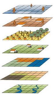
15

16 Computer Aided Design on The Throne


17 Evolution
18
19


20


21

22 Industry Data Trends Asset Management Digital GIS Work orders Home grown DBs Paper maps/binders Custom GIS w/ Assets No data
23 Data In Information Out Single Proprietary Software Solution Proprietary Services Tabular Data Proprietary Middleware Proprietary GIS data Reference Data
24 Solution 1 Solution 4 Open Data Solution 2 Solution 3


25 Open Data


26 Beehive Framework Local Government Solutions Properties Staff Features Events Time Materials Fees Documents Beehive Framework

27 Big Data & the Razzle Dazzle
28 Data Quality in Time and Space Big data in time tracking Big data in asset lifecycle Completeness vs association vs location Transition - The Three Legged Dog Syndrome Transition The Cortez Option Demo Histogram Demo Analytics
29 Spatial is not a system, it s just data Data is the tool. Information is the goal
30 Simplicity makes it more powerful, not less Simplicity makes it more flexible, not less Simplicity makes it faster

31 The State of the Technology Union


32 State of the Industry


33 Where We Came From CADD Roots ArcView 3x Avenue


34 Progress was slow, but steady Web mapping technologies Pre-built map-based tools

35 Where we are Going Geospatial data sets integrated into dept. processes GIS data is unlocked when it is viewed as another set of data The Google generation Spatially integrated applications Mobile, mobile, mobile


36 Where we are Going Data integration across platforms Integration of multiple data sets
37 Asset Management For All Originally built for large cities Cost prohibitive for small to mid-sized cities Same level of need at the mid-sized city level

38 Three levels of Asset Management None Invested some time/money, but not dependent Thoroughly invested in Asset Management, rely on AM software for daily workflows
39 Level One No experience to very little GIS/AM experience on staff No investment in GIS data Knowledge that GIS can be a powerful tool, but not sure how to leverage it Still more questions than answers
40 Level Two Staff has experience with GIS/AM Some data sets have been created Subdivisions, Lots, Parcels Pipes, valves, hydrants, meters Zoning, land use Knowledge of GIS and data, but now unsure about how to fully leverage an AM solution
41 Level Three Multiple staff trained in GIS Many district-wide data sets have Multiple groups creating data that is shared organization-wide Totally reliant on GIS data to fuel AM applications
42 Benefits of Asset Management Succession planning becomes much easier Retiring workforce Transitory workforce Strategic Budgeting/CIP better defined Risk Mitigation Time-savings across departments

43 Asset Management No System in place Pros No additional work load for staff Cons Back to the Who knows approach

44 Asset Management Half Way to Asset Management Pros You can say you are doing something Cons Potential to create bottleneck in communication

45 Asset Management All in Asset Management Pros Full integration into multiple datasets Greater depth in layering and design functionality Cons Possibly running into proprietary data

46 Technology Overview Integrating data, both spatial and tabular, to better inform, manage and navigate your ever changing world. Provide you with the ability to manage that data, both in the office and in the field.
")


47 Technology Options ESRI (or similar) mapping products Mapping product with 3rd party database Standalone management system


48 Technology Options Bringing these three together is the best possible solution for asset management technologies
49 Integrated System Laptop Entry/Edit Mobile Form Entry Web Form Entry Multi-user data editing Search, visualize, and QA/QC Query DB Query Map Report Creation Web Reporting Web Mapping Reporting and sharing
50 Integrated System Overview Search Mapping integration Property (tabular) data integration Event information Work planning/management (Work Order) Reporting Mobile solutions


51 Key Benefits of Technology EFFICIENT SIMPLE FLEXIBLE POWERFUL
52 Level One: Next Steps Assemble any digital data Begin compiling mapping data Scan/digitize paper records, valve cards, etc. Utilize county/state relationships for data sharing
53 Level Two: Next Steps Explore potential ways GIS/Mapping can be integrated asset inventory and asset history Digitize any remaining paper records of asset history Begin effort to break down department silos of information
54 Level Three: Next Steps Operationalize data and break down silos Make data more easily accessible to field staff Begin effort to make citizen access and engagement improvements

55 Questions? Mike Schwab Solutions Architect
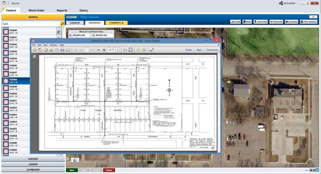
56 Use Case Consolidated Water District #1 Leavenworth County, Kansas
57 Use Case Assemble any digital data Begin compiling mapping data Scan/digitize paper records, valve cards, etc. Utilize software platform for simplified data entry

58 Use Case

59 Use Case


60 Use Case

61 Use Case


62 ELECTRIC STREET LIGHTS WASTEWATER PUBLIC ACCESS CODE COMPLIANCE STORM/M S4 STREETS ADDRESS E311 TREATMENT PLANT WATER SIGNS SIGNALS FLEET NATURAL GAS CEMETERY FACILITIES PERMITTING SNOW REMOVAL SNOW REMOVAL
63

64

65
66

67


68

69

70
A Better Way to Manage Assets and Infrastructure. Mutasem Jokhdar InfoGraph
 A Better Way to Manage Assets and Infrastructure Mutasem Jokhdar InfoGraph TITLE SLIDE InfoGraph (Founded in 1991) InfoGraph Specialty is Geographic Information Systems (GIS) & Remote Sensing software
A Guide for Local Governments: EAM and GIS for Complete Asset Management
 29 91 $1,487 A Guide for Local Governments: EAM and GIS for Complete Asset Management A Guide for Local Governments: EAM and GIS for Complete Asset Management Think back to a time before smartphones. You
GEOGRAPHIC INFORMATION SYSTEMS (GIS) INVENTORY OF ASSETS
 INVENTORY OF ASSETS") GEOGRAPHIC INFORMATION SYSTEMS (GIS) INVENTORY OF ASSETS Presented by Sherry Loos, GISP, RCAP State Coordinator David Garretson, GIS Database Administrator You have a lot of stuff to maintain and manage.
GEOGRAPHIC INFORMATION SYSTEMS (GIS) INVENTORY OF ASSETS Presented by Sherry Loos, GISP, RCAP State Coordinator David Garretson, GIS Database Administrator You have a lot of stuff to maintain and manage.
Esri Solutions for Weather Maintenance Snow and Ice Management
 Esri Solutions for Weather Maintenance Snow and Ice Management Become a Modern Snow Fighter Today s winter maintenance professionals use geographic information system (GIS) technology to meet the challenges
GIS Consortium BUILDING SMARTER COMMUNITIES
 GIS Consortium BUILDING SMARTER COMMUNITIES residents GIS Consortium Overview Geographic Information Systems (GIS) is an integral tool for cities. It enables efficient and effective planning and implementation
The City of Tacoma s GIS-Centric Wastewater Asset Performance Modeling Approach
 The City of Tacoma s GIS-Centric Wastewater Asset Performance Modeling Approach Tacoma s Sanitary Sewer Upfront Information Tacoma is located within Puget Sound on Commencement Bay Over 90,000 Customers
Esri Roads and Highways An Introduction. Nathan Easley Rahul Rakshit
 Esri Roads and Highways An Introduction Nathan Easley Rahul Rakshit Roads and Highways Linear Referencing for the Transportation Enterprise GIS-enabled LRS platform LRS management LRS editing & maintenance
Modernizing and Strengthening Pipeline GIS. Jeff Allen, Anjali Bhangay, Tom Coolidge and Vanessa Ramirez
 Modernizing and Strengthening Pipeline GIS Jeff Allen, Anjali Bhangay, Tom Coolidge and Vanessa Ramirez Agenda Overview of ArcGIS for Pipeline Demo System of Record UPDM and the Utility Network System
10/22/2018. Asset Management with GIS. Asset Management with GIS. Asset Management with GIS. Asset Management with GIS. Asset Management with GIS
 2 Asset Management Utilizing A Framework for Managing the Asset Life Cycle Mike Liska, P, HR Green Iowa Section American Water Works Association Annual Conference Dubuque, IA October 17, 2018 HR Green,
Presented by John Hudler Geospatial Group Leader Office of Transportation Data Georgia Department of Transportation
 Presented by John Hudler Geospatial Group Leader Office of Transportation Data Georgia Department of Transportation Collection, Quality Assurance and Reporting of the States roadway and transportation
Configuring for Agility: A Strategy for Sustainable Apps. Christian Carlson Scott Oppmann
 Configuring for Agility: A Strategy for Sustainable Apps Christian Carlson Scott Oppmann Why do you care? Generate greater return from your platform investments Mitigate service delivery issues Transition
Clean Water 2020 Program
 Clean Water 2020 Program INFRASTRUCTURE REHABILITATION PROGRAM (IR Program) November 2016 Updated March 2017 Table of Contents Infrastructure Rehabilitation Program 2016 List of Tables... 2 List of Figures...
Public Asset Management Local Government Asset Lifecycle
 Public Asset Management Local Government Asset Lifecycle Introductions Brent Wilson Executive Director of Sales Azteca Systems Inc. Cityworks 214-507-0579 bwilson@cityworks.com Copyright 2012-2013 Azteca
Campus Enterprise GIS
 Campus Enterprise GIS Cross Platform Supported: Enterprise GIS Initiative: Webmapping Making the Case for Enterprise GIS at UMD Esri Resources Available to UMD Webmapping for Information Access Demonstration:
From Silos to Integration A Transformation Journey at City of Ottawa
 From Silos to Integration A Transformation Journey at City of Ottawa Devesh Shah, P.Eng. Program Manager, Asset Management Strategy, Environmental Services Department, City of Ottawa June 9, 2014 SHNSNBKJSGN
April Oracle Spatial User Conference
 Oracle Spatial User Conference Ron Little Oshawa PUCN Geoff Cameron - AGSI An Innovative and Open Approach to Utilities Network Management at Oshawa PUC Agenda OPUCN Geospatial History Approach Process
ArcGIS for Transportation. Tom Brenneman, Gary Waters
 ArcGIS for Transportation Tom Brenneman, Gary Waters ArcGIS for Transportation A product for Esri s transportation customers A series of useful maps and apps focused on transportation Organized into modules
ArcGIS for Water Utilities: An Introduction
 Esri International User Conference San Diego, California Technical Workshops July 26, 2012 ArcGIS for Water Utilities: An Introduction Howard Crothers Mike Miller Agenda Introduction ArcGIS for Water Utilities
Migrating 20-years of Spatial Data. The Knoxville, Knox County, Knoxville Utilities Board (KGIS) Experience
 Experience") Migrating 20-years of Spatial Data and Applications to a Modern GIS The Knoxville, Knox County, Knoxville Utilities Board (KGIS) Experience KGIS Knoxville Knox County Knoxville Utilities Board Knoxville,
Migrating 20-years of Spatial Data and Applications to a Modern GIS The Knoxville, Knox County, Knoxville Utilities Board (KGIS) Experience KGIS Knoxville Knox County Knoxville Utilities Board Knoxville,
CHAPTER 6 COLLECTION SYSTEM HYDRAULIC MODEL
 CHAPTER 6 COLLECTION SYSTEM HYDRAULIC MODEL INTRODUCTION The District developed a hydraulic model of the sanitary sewer system as part the 2000 Wastewater Comprehensive Plan. The output from this model
UPPER HUTT CITY COUNCIL, NEW ZEALAND
 CUSTOMER INNOVATION STUDY UPPER HUTT CITY COUNCIL, NEW ZEALAND Achieves advanced asset management Infor Public Sector underpins the city s lifecycle asset management activities from creating to operating,
Copyright 2014, Oracle and/or its affiliates. All rights reserved
 Copyright 2014, Oracle and/or its affiliates. All rights reserved Agenda Business Analytics Oracle Business Intelligence Map Visualization Location Intelligence 3 Key Issues What trends are driving analytics?
GIS and Asset Management: a Cost Efficient Enterprise Solution
 GIS and Asset Management: a Cost Efficient Enterprise Solution Ming Zhao & Geoffrey Stevens Abstract: Utilities are facing significant challenges and opportunities in developing cost effective business
Digital Transformation and Operational Intelligence in Utilities. Agendra Kumar President, Esri India
 Digital Transformation and Operational Intelligence in Utilities Agendra Kumar President, Esri India Agenda Market Observations and Trends Role of GIS Vision and Road Map for Smart Utilities Summary and
I S D I G I TA L S T R AT E G Y
 IS DIGITAL STRATEGY IS DIGITAL STRATEGY Background Process Findings Key Projects DIGITAL STRATEGY BACKGROUND Why a Digital Strategy? Develop the foundation to support existing & new services Kelowna needs
Applying Surveying Expertise to become
 From Maps to Models Applying Surveying Expertise to become The Spatial Information Manager Mark Nichols Trimble Vice President Our History and Our Future from Maps to Models Technology changes have improved
GIS-based Facility Information Management Systems : an evolving success story
 : an evolving success story By Avinash Srivastava and Brad Wellington EDAW, Inc. Abstract : (FIMS) offer several advantages over traditional CAD-based FIMS systems, particularly in integrating land management
Extending the Value of Maximo Solutions
 Extending the Value of Maximo Solutions Mobile, Spatial, and other technologies that extend support for asset and service management best practices Agenda Service Management World Tour The The purpose
2018 ASSET MANAGEMENT SYSTEM ADDENDUM # 1 TO REQUEST FOR PROPOSALS
 2018 ASSET MANAGEMENT SYSTEM ADDENDUM # 1 TO REQUEST FOR PROPOSALS 1. How many Users will be using the system to process work as well as manage inventory and assets? These users would be utilizing the
Intelligent Water and Organizational Culture
 WATER 2.0 Intelligent Water and Organizational Culture February 26, 2013 30 Rockefeller Center, New York, NY 1 Intelligent Water 0.5 Courtesy of Waterford Township DPW 2 In an effort to move toward greater
Using GPS/GIS Technology via BlackBerry Phones for Managing Public Works Programs
 Using GPS/GIS Technology via BlackBerry Phones for Managing Public Works Programs Scott E. Roberts, GISP, Director of Information Technology NEURISA 2010 October 18, 2010 Our Vision-How Did We Start? How
Hurricane Matthew Preparedness & Recovery with Cityworks
 Hurricane Matthew Preparedness & Recovery with Cityworks Esri Water Conference Feb 7-9, 2017 Orlando Fl. Greg Baird Director of Enterprise Strategies Cityworks gbaird@cityworks.com With Asset Management
Utilizing Geospatial Tools to Collect and Analyse Asset Data in the City of Manchester, New Hampshire
 Utilizing Geospatial Tools to Collect and Analyse Asset Data in the City of Manchester, New Hampshire Katherine Keegan, AECOM Pavement Group Leader Jonathan Gould, AECOM Senior Pavement Engineer 11 th
Transportation Report to SPC on Transportation and Transit 2017 April 19. ISC: UNRESTRICTED TT Page 1 of 7
 Page 1 of 7 EXECUTIVE SUMMARY The City of Calgary owns and maintains over 12,200 km of sidewalks, curbs and gutters with a current replacement value of $5.1 billion. The quality of new concrete and condition
ArcGIS for Local Government Solutions: An Overview. Rachel Weeden, Esri Patrick Callahan, Prince George s County
 ArcGIS for Local Government Solutions: An Overview Rachel Weeden, Esri Patrick Callahan, Prince George s County ArcGIS is a Platform Knowledge Workers Executive Access Public Engagement Work Anywhere Enterprise
Hosted by: M Squared Engineering on behalf of the Illinois Department of Transportation Thursday, February 9, 2012 Eiger Lab, Rockford, IL
 Hosted by: M Squared Engineering on behalf of the Illinois Department of Transportation Thursday, February 9, 2012 Eiger Lab, Rockford, IL TECHNICAL SUPPORTIVE SERVICES IN IDOT DISTRICTS 2 & 3 FOR CERTIFIED
Smarter Infrastructure. Management Using Fully. Integrated Asset. Management System. - City of Ottawa's Journey
 Canadian Maximo User Group, May 28, 2014 Smarter Infrastructure Management Using Fully Integrated Asset Management System - City of Ottawa's Journey Devesh Shah, P.Eng. Program Manager, Asset Management
Address Maps and Apps for State and Local Governments NIKKI GOLDING CHRIS FOX SCOTT OPPMANN
 Address Maps and Apps for State and Local Governments NIKKI GOLDING CHRIS FOX SCOTT OPPMANN Agenda Introduction Solution Offering What s Next Your Feedback ArcGIS as a Platform Simple, Open, and Configurable
CITY OF ALBANY Public Works Department ADDENDUM #1 ST , MAIN STREET REHABILITATION
 CITY OF ALBANY Public Works Department ADDENDUM #1 ST-13-04-2014, MAIN STREET REHABILITATION In order to clarify the intent of the Specifications and Drawings, the following provisions are provided and
DATE: September 8, 2014 REPORT NO. PW Chair and Members Committee of the Whole Operations and Administration
 PUBLIC WORKS COMMISSION DATE: September 8, 2014 REPORT NO. PW2014-047 TO: FROM: Chair and Members Committee of the Whole Operations and Administration Geoff Rae, MBA, P.Eng. General Manager, Public Works
City of Lawrence, Kansas
 Table of Contents 1 EXECUTIVE SUMMARY... 1-1 1.1 General Overview... 1-1 1.2 Phase 1 Field Investigation Findings... 1-3 1.2.1 Public Sector Inflow/Infiltration Sources... 1-3 1.2.2 Private Sector Inflow/Infiltration
Simplifying Asset Management: It s About What s In It for You?
 I N T E R M E D I A T E Simplifying Asset Management: It s About What s In It for You? PRESENTED BY HEATHER HIMMELBERGER What is the Story of Your Utility? Assets What Assets Do You Have? What Would You
Comparing Tools for Managing Infrastructure. VUEWorks. September 15, 2016
 Comparing Tools for Managing Infrastructure VUEWorks September 15, 2016 Foundations (10 Minutes) 2 1 3 VUEWorks Performance-Based Asset Management - Forecast capital budget needs - Create & manage
Planning Analytics for Asset Lifecycle Management (PALM)
") Thursday, October 25, 2012 Shilpa Mahatma IBM Research Planning Analytics for Asset Lifecycle Management (PALM) City agencies need to co-ordinate the planning and management of assets to improve the quality
Thursday, October 25, 2012 Shilpa Mahatma IBM Research Planning Analytics for Asset Lifecycle Management (PALM) City agencies need to co-ordinate the planning and management of assets to improve the quality
Water and Wastewater Capital Improvement Plan Options and Revenue Requirements
 Water and Wastewater Capital Improvement Plan Options and Revenue Requirements The Master Plan s objectives are to assess our needs and recommend Capital Improvement Plans that address the following: Infrastructure
Mobile Government: Crucial Conversations. Lee Johnston, Jr, Joseph Peters, Jim Long, Tom Krinke
 Mobile Government: Crucial Conversations Lee Johnston, Jr, Joseph Peters, Jim Long, Tom Krinke ArcGIS Common Patterns of Use Mapping & Visualization Data Management Field Mobility Monitoring Analytics
GE Digital Consistency, Efficiency and Accountability. Water Solutions
 GE Digital Consistency, Efficiency and Accountability Water Solutions 1 Water Utilities spend over $1,000,000,000 on controls and IT every year with the goal of increasing operational efficiency, consistency
A GIS Powered Smart Utility
 A GIS Powered Smart Utility August 2010 OZRI Conference 2011 Sharon McAnelly - Program Director, PWC Peter Burgun Solution Architect, IBM Agenda Power and Water Corporation, Northern Territory The Asset
field-data collection & reporting
 a new standard in field-data collection & reporting A powerful and secure solution for collecting field-data and managing your company s field-based assets Our goal was to create a mobile application with
7 Trends Impacting How We Use Digital Assets
 7 Trends Impacting How We Use Digital Assets Key Considerations for Creating, Managing, Delivering, and Optimizing Content 1 7 Trends in Digital Asset Use 91% Today s customers demand engaging visual content
Thriving Ports in a Competitive Environment
 Thriving Ports in a Competitive Environment Bring Location Intelligence to Your Port The international maritime market is changing. With the globalization of supply chains and shifting demand for goods
CITY OF GARLAND - ENGINEERING DEPARTMENT - PRIVATE DEVELOPMENT PAVING SUMMARY CASE NUMBER: PROJECT NAME: CONTRACTOR: PHONE NUMBER: (rev.
 PAVING SUMMARY 5" Concrete Street Paving including curbs 6" Concrete Street Paving including curbs 7" Concrete Street Paving including curbs 8" Concrete Street Paving including curbs 8-5-8 Concrete Alley
2015 Annual Report. Prepared For The: City of Lyndhurst. By the DEPARTMENT OF PUBLIC WORKS
 2015 Annual Report Prepared For The: City of Lyndhurst By the DEPARTMENT OF PUBLIC WORKS OVERVIEW Established in 1919, the office of the Cuyahoga County Sanitary Engineer was created to provide administrative
GIS in Public Works: Real-time, Analytical, Collaborative and Engaged. Mike Dyer and Anthony Myers
 GIS in Public Works: Real-time, Analytical, Collaborative and Engaged Mike Dyer and Anthony Myers Challenges for Public Works Organizations Aging infrastructure Limited funding for repairs Rising costs
Valve Assessment-Asset Management
 Valve Assessment-Asset Management through Valve Location, Exercising, Documentation and GIS Todd Schaefer Regional Manager ISAWWA-June 2012 Why Distribution Valves are so important to control of your water
Presenter: Peter C. Gorham, P.E. Director of Engineering
 Presenter: Peter C. Gorham, P.E. Director of Engineering Project Management Group 3 Engineers 5 Construction Inspectors 1 Environmental Compliance Specialist 1 Regulatory Compliance Specialist 1 Engineering
City of Berkley, Michigan Harvard Road Reconstruction & Water Main Replacement Project FREQUENTLY ASKED QUESTIONS (FAQ)
") FREQUENTLY ASKED S (FAQ) The purpose of this document is to provide detailed information about the Harvard Road Reconstruction & Water Main Replacement Project. This project will directly affect residents
FREQUENTLY ASKED S (FAQ) The purpose of this document is to provide detailed information about the Harvard Road Reconstruction & Water Main Replacement Project. This project will directly affect residents
Esri Roads and Highways An Introduction
 Esri International User Conference San Diego, California Technical Workshops July 24, 2012 Esri Roads and Highways An Introduction William Isley Majunu Seran Agenda Product Overview Desktop - Demo: Network
The Cloud Revolution:
 GITA GIS for Oil & Gas Pipeline Conference The Cloud Revolution: Leveraging Cloud Computing for GIS Success October 26, 2011 Today s Speakers Jim Skurzynski, President & CEO, Digital Map Products Jim has
Capacity Assurance in Charlotte s Central Business District
 November 2017 Capacity Assurance in Charlotte s Central Business District Micah Burgess, PE Barbara Moranta, PE October 2017 Charlotte Water Facts Provides Water and Sanitary Sewer Service to Mecklenburg
Capital Planning and ROW Permitting Maps and Apps for Local Government. Chris Fox Scott Oppmann
 Capital Planning and ROW Permitting Maps and Apps for Local Government Chris Fox Scott Oppmann Agenda Introduction Solution Offering What s Next Your Feedback ArcGIS Solutions for Local Government Improving
ArcGIS for Local Government Public Works Solutions. Scott Oppmann
 ArcGIS for Local Government Public Works Solutions Scott Oppmann GIS Is Evolving Your GIS Is Becoming Part of an Interconnected Platform Apps Web GIS Desktop Community Content Server Bringing Together
State and Local Governments
 Public Engagement Maps and Apps for State and Local Governments ALLISON MUISE SCOTT OPPMANN Agenda Introduction Public Engagement Maps and Apps What s Next Your Feedback ArcGIS as a Platform Simple, Open,
Asset Management and Data Collection using Digital Video / GPS Data Extraction Techniques
 Asset Management and Data Collection using Digital Video / GPS Data Extraction Techniques TRB 6 th National Conference on Transportation Asset Management Kansas City, Missouri November 2, 2005 Presentation
DelDOT s. Online Resource. Information. For. Network. Mapping
 DelDOT s Information Network For Online Resource Mapping What is INFORM? Information Network For Online Resource Mapping DelDOT s s Web-based based GIS Application Centralized Source for DelDOT GIS Data
PUBLIC WORKS DEPARTMENT GENERAL NOTES
 PUBLIC WORKS DEPARTMENT GENERAL NOTES 1. All construction shall be in strict accordance with the standards of the City of Southlake and governed by the North Central Texas Council of Government's Standard
TOWN OF MOUNT PLEASANT WESTCHESTER COUNTY, NEW YORK
 TOWN OF MOUNT PLEASANT WESTCHESTER COUNTY, NEW YORK COST EVALUATION FOR ROLLING HILLS AREA WATER MAIN EXTENSION PROFESSIONAL CONSULTING, LLC. Octagon 10, Office Center 1719 Route 10, Suite 225 Parsippany,
Infrastructure Data Management Using ArcGIS and Hansen. By: Clay Wise, City of Virginia Beach & Brian Wienke, Hansen Information Technologies
 Infrastructure Data Management Using ArcGIS and Hansen By: Clay Wise, City of Virginia Beach & Brian Wienke, Hansen Information Technologies Purpose We are here to discuss the process of achieving a complete
GIS & ASSET MANAGEMENT SERVICES
 GIS & ASSET MANAGEMENT SERVICES TECHNOLOGY CONSULTING Accessibility to data no matter the industry or location is critical to maintaining efficiency, accuracy and the ability to keep business flowing.
Enhancing the Auckland Digital Experience. Mike Foley Head of Information Services Auckland Council
 Enhancing the Auckland Digital Experience Mike Foley Head of Information Services Auckland Council Delivering on the goal of the super city World s Most Liveable City The Auckland Plan is our 30 year
WHITE PAPER COMING OF AGE
 WHITE PAPER COMING OF AGE Credit Unions Must Position Themselves Now to Compete in Today s Tech Landscape CONTENTS Executive summary 3 01 Navigating the Credit Union Landscape for Change 4 02 Where the
ENGINEERING DEPARTMENT. Provide engineering and public improvements in the most economical manner.
 ENGINEERING DEPARTMENT MISSION STATEMENT: Provide engineering and public improvements in the most economical manner. The Engineering Department performs the following services to maintain and improve the
GPS & GIS for Hurricane Debris Removal. City of Miami Miami, Florida
 GPS & GIS for Hurricane Debris Removal City of Miami Miami, Florida June 19, 2007 ESRI UC 2007 Presenters Regina L. Hagger GIS Developer City Of Miami Department of Public Works Michael Schmedt GIS Analyst
Public Works Maps and Apps for Local Governments CHRIS FOX SCOTT OPPMANN
 Public Works Maps and Apps for Local Governments CHRIS FOX SCOTT OPPMANN Agenda Introduction Solution Offering What s Next Your Feedback ArcGIS as a Platform Simple, Open, and Configurable Knowledge Workers
REQUEST FOR QUALIFICATIONS UTILITY LAYOUT MAPPING AND PLAN OF RECORD AS BUILT DRAWINGS RFQ Q MR ADDENDUM #2 10:00 AM November 18, 2010
 REQUEST FOR QUALIFICATIONS UTILITY LAYOUT MAPPING AND PLAN OF RECORD AS BUILT DRAWINGS RFQ Q 10 019 MR ADDENDUM #2 10:00 AM November 18, 2010 This addendum notifies of changes to the due date, the estimated
ELECTRIFYING AGDS an Power Story
 ELECTRIFYING AGDS an Power Story Presentation Outline Speaker Introductions ENMAX - GIS Background JUMP & Facility Locates Data Structures GIS Primary Connectivity Applications using Connectivity OMS &
City of Fairview Park
 Cuyahoga County Together We Thrive 2016 ANNUAL REPORT Prepared For The: City of Fairview Park By the DEPARTMENT OF PUBLIC WORKS OVERVIEW Department of Public Works Established in 1919, the office of the
Town of Middleborough Department of Public Works
 Town of Middleborough Department of Public Works August 25, 2014 The practice of planning for pavement maintenance and rehabilitation with the goal of maximizing the value and life of a pavement network
Sidewalk Repair Program. Charter Township of Canton Engineering Services
 Sidewalk Repair Program Charter Township of Canton Engineering Services Sidewalk Repair Program History Canton lost a landmark case at the Michigan Supreme Court level in 1997. The Supreme Court has determined
HOW LOCATION INTELLIGENCE DRIVES ELECTIONS. A Geographic Approach to Improving Voter Outreach and Constituent Engagement
 HOW LOCATION INTELLIGENCE DRIVES ELECTIONS A Geographic Approach to Improving Voter Outreach and Constituent Engagement GIS AND ELECTIONS CONTENT INTRODUCTION THE INTELLIGENT MAP BUILT IN LOCATION INTELLIGENCE
MAKING TFL DIGITAL: WEB, OPEN DATA AND BEYOND! Phil Young Head of TfL Online!!
 MAKING TFL DIGITAL: WEB, OPEN DATA AND BEYOND! Phil Young Head of TfL Online!! Overview Background the TfL challenge Context our digital strategy What customers want our digital strategy Insights mobility
SUMMARY OF PUBLIC WORK STANDARD SPECIFICATION REVISIONS 2017
 SUMMARY OF PUBLIC WORK STANDARD SPECIFICATION REVISIONS 2017 STANDARD SPECIFICATIONS 102.12 Best Value Contracting Partial payments shall be withheld if contractor is working on site and has not satisfied
Establishing Data Fusion Center Baseline Technology Capabilities. Paul Christin ESRI David Stampfli Microsoft
 Establishing Data Fusion Center Baseline Technology Capabilities Paul Christin ESRI David Stampfli Microsoft Problem The asymmetrical threat of organized crime, gangs, drug cartels and terrorist organizations
Resilient Asset Management System. Aakavs Consulting Arnab Bhowmick (425)
") Resilient Asset Management System Aakavs Consulting Arnab Bhowmick (425) 245-3569 arnab@aakavs.com Intro Portfolio Solve Biz Issues in Local Govt. Asset Management vs. Maintenance Management Strategies
Resilient Asset Management System Aakavs Consulting Arnab Bhowmick (425) 245-3569 arnab@aakavs.com Intro Portfolio Solve Biz Issues in Local Govt. Asset Management vs. Maintenance Management Strategies
Terminology. GIS Centric Computerized Maintenance Management System (CMMS) Public Asset Management System (also known SCAUG
 Public Asset Management System (also known SCAUG") Jeremy White Regional Account Manager Cityworks Azteca Systems SCAUG 2011 1 Terminology GIS Centric Computerized Maintenance Management System (CMMS) Public Asset Management System (also known as AMS)
Jeremy White Regional Account Manager Cityworks Azteca Systems SCAUG 2011 1 Terminology GIS Centric Computerized Maintenance Management System (CMMS) Public Asset Management System (also known as AMS)
**RESPONSES TO COMMENTS MUST BE RETURNED WITH REVISED PLANS FOR FINAL PLAN APPROVAL.** Approved as submitted X Needs attention N/A Non-Applicable
 PLAN REVIEW CHECKLIST FOR WATER MAINS AND SANITARY SEWERS CITY OF ANDERSON / ELECTRIC CITY UTILITIES ************************************************************************************* Project Name:
Mapping Capital Improvement Program Projects at the City of Austin
 Mapping Capital Improvement Program Projects at the City of Austin Abstract The CIP feature class is a cross-departmental solution for mapping Capital Improvement Program (CIP) projects at the City of
From IT Service Management to DevOps. Speaker: JP Morgenthal
 From IT Service Management to DevOps Speaker: JP Morgenthal Twitter: @jpmorgenthal About the Speaker CSC - Distinguished Engineer Specializations in Digital Transformation, Cloud Computing, DevOps and
Creating a Workforce Development Plan with Esri. Tamara Adamson Justin Ogden
 Creating a Workforce Development Plan with Esri Tamara Adamson Justin Ogden Agenda What is Esri training? Why is training important? How we engage through training What is a workforce development plan?
Enterprise GIS Water Utility Data Migration: Service Location Case Study
 Enterprise GIS Water Utility Data Migration: Service Location Case Study Anthony Pologruto, GIS Analyst Joe DeLuca, Project Manager Since 1942 Services Serve over 140,000 customers. Provide both water
Advanced Enterprise Work and Asset Management for Performance-Driven Utilities
 Advanced Enterprise Work and Asset Management for Performance-Driven Utilities Asset & Resource Management (ARM) 2 CGI s Asset & Resource Management (ARM) 2 suite is a solution designed to streamline the
Practical Applied Asset Management for Public Transit. Tim Quinn thingtech, CEO Atlanta, GA
 Practical Applied Asset Management for Public Transit Tim Quinn thingtech, CEO Atlanta, GA Confidential and Proprietary MAP21 and TAM Section 5326 - National Transit Asset Management System Through MAP
This is a digital document from the collections of the Wyoming Water Resources Data System (WRDS) Library.
 Library.") This is a digital document from the collections of the Wyoming Water Resources Data System (WRDS) Library. For additional information about this document and the document conversion process, please contact
This is a digital document from the collections of the Wyoming Water Resources Data System (WRDS) Library. For additional information about this document and the document conversion process, please contact
Creative Ways to better Manage your Infrastructure, new and emerging Technology. Karen Stewart Esri Canada
 Creative Ways to better Manage your Infrastructure, new and emerging Technology Karen Stewart Esri Canada Traffic camera Electric wiring Information portal Road signage Viaduct Traffic sign Canal Fleet
ArcGIS for Local Government: An Overview SCOTT OPPMANN
 ArcGIS for Local Government: An Overview SCOTT OPPMANN Agenda Introduction Why? Solution Offering What s Next Your Feedback Using ArcGIS to understand and mitigate challenges Housing Forecasting Urban
Leveraging GIS to Improve Operations and Asset Management Lifecycle
 Leveraging GIS to Improve Operations and Asset Management Lifecycle Gabriel Borroni Joel Gladfelter ESRI AEC Summit 2014 San Diego, CA Asset Management Inventory Control Maintenance Management Scheduling/
How to Collect and Manage Requirements for Successful GIS Projects. Matt Harman Mirjam Stadelmann
 How to Collect and Manage Requirements for Successful GIS Projects Matt Harman Mirjam Stadelmann Requirements Provide direction for program success Why Requirements are Important? Early mistakes lead to
CONSTRUCTION SURVEY. Construction survey includes personnel, equipment, and supplies required for, but not limited to, the following:
 CONSTRUCTION SURVEY PART 1 - GENERAL 1.01 SECTION INCLUDES Construction survey includes personnel, equipment, and supplies required for, but not limited to, the following: A. Construction Survey: 1. Project
Robert Parsons GIS Director Delaware County Auditor s Office Travis Gregorich Bruce Harris & Associates Account Manager
 Improving Real Estate Appraisal and Assessment using ArcGIS Robert Parsons GIS Director Delaware County Auditor s Office Travis Gregorich Bruce Harris & Associates Account Manager Delaware County, Ohio
General Departmental Summary
 Summer Gravel Road Maintenance General Departmental Summary This quarter has been fairly routine. We have had no water main breaks in the past three months, however we have performed routine maintenance