For. Report of Geotechnical Exploration. University of North Florida Parking Lot 47 Jacksonville, Florida
|
|
|
- Bartholomew Norris
- 6 years ago
- Views:
Transcription

 519-6990 Fax")
1 Report of Geotechnical Exploration For University of North Florida Parking Lot 47 Jacksonville, Florida MAE Project No April 5, 2017 Revised: April 6, 2017 Prepared for: Prepared by: Jacksonville, Florida Phone (904) Fax (904)
2 April 5, 2017 Revised: April 6, 2017 Mr. William J. Byers, P.E. GAI Consultants, Inc Riverplace Boulevard, Suite 900 Jacksonville, Florida Reference: P. Rodney Mank, State of Florida, Professional Engineer, License No This item has been electronically signed and sealed by P. Rodney Mank, P.E. on 04/06/2017 using a Digital Signature. Printed copies of this document are not considered signed and sealed and the signature must be verified on any electronic copies. Report of Geotechnical Exploration University of North Florida (UNF) Parking Lot 47 Jacksonville, Florida MAE Project No Dear Mr. Byers: Meskel & Associates Engineering, LLC (MAE) has completed a geotechnical exploration for the subject project. Our work was performed in general accordance with our updated proposal of April 20, The existing parking lot had several areas where depressions had formed at the surface. The purposes of this geotechnical exploration were to measure the thickness of the existing pavement structure (asphalt surface, base course and stabilized subgrade if encountered) within the existing UNF Parking Lot 47, and to explore underlying subgrade soils for any unsuitable soils, particularly any unsuitable organic soils/muck and clays. This report replaces our original report dated April 5, 2017 in its entirety. In summary, the pavement cores encountered a surficial asphalt course ranging from 1-1/2 to 2-1/4 inches in thickness, underlain by a limerock base course that ranged from 6 to 8-1/2 inches in thickness. The soil borings encountered predominately sands ( soils) below the limerock base course to a depth of 5 to 6 feet below the pavement surface. Below the soils, the borings encountered silty sands (A-2-4 soils) containing few amounts of organic fines and root fragments to the boring termination depths of 7 to 7-1/2 feet below the pavement surface. Groundwater was measured at depths of about 4, 11 to 6, 6 below the pavement surface. The cores encountered the limerock in a generally dry state, and no evidence of limerock staining was observed on the pavement surface. Based on our observations and the results of our field exploration, it is our opinion that the encountered subsurface conditions are favorable for support of the pavement structure. We appreciate this opportunity to be of service as your geotechnical consultant on this phase of the project. If you have any questions, or if we may be of any further service, please contact us. Sincerely, MESKEL & ASSOCIATES ENGINEERING, LLC MAE FL Certificate of Authorization No W. Josh Mele, E.I. Staff Engineer Distribution: signed Philip R Digitally by Philip R Mank Date: Mank 12:43:23-04'00' P. Rodney Mank, P.E. Principal Engineer Licensed, Florida No Mr. William J. Byers, P.E. GAI Consultants, Inc. Jacksonville, Florida Phone: (904) Fax: (904) pdf
3 University of North Florida Parking Lot 47 MAE Project No TABLE OF CONTENTS Subject Page No. PROJECT INFORMATION... 1 Project Description & Site Conditions... 1 FIELD EXPLORATION... 1 Pavement Cores... 1 Auger Borings... 1 LABORATORY TESTING... 2 GENERAL PAVEMENT & SUBSURFACE CONDITIONS... 2 Pavement Core Samples... 2 General Soil Profile... 2 Groundwater Level... 3 EVALUATION OF ENCOUNTERED SUBSURFACE CONDITIONS... 3 General... 3 SITE PREPARATION AND EARTHWORK RECOMMENDATIONS... 3 Stripping of Existing Pavement Materials... 3 Removal of Existing Subgrade... 4 Compaction... 4 Subgrade Backfill... 4 Pavement Layer... 5 QUALITY CONTROL TESTING... 5 REPORT LIMITATIONS... 5 FIGURES Figure 1. Figure 2. Figures 3-4. APPENDICES Appendix A. Appendix B. Appendix C. Site Location Plan Core / Auger Location Plan Generalized Soil Profiles Soil Boring Logs Field Exploration Procedures Key to Boring Logs Key to Soil Classification Summary of Laboratory Test Data Laboratory Test Procedures Pavement Core Photographs Jacksonville, Florida Phone: (904) Fax: (904) Page i
4 University of North Florida Parking Lot 47 MAE Project No PROJECT INFORMATION 1.1 Project Description & Site Conditions Project information was provided to us by Mr. William Byers, P.E. with GAI Consultants, Inc. The general project location is on the northeast corner of the intersection of Alumni Drive and UNF Drive within the University of North Florida (UNF) campus, which is north of JTB Boulevard and east of I-295 in Jacksonville, Duval County, Florida. The general site location is shown on Figure 1. We understand that Parking Lot 47 supports a Parking and Transportation Services office that provides parking permits to students and visitors to the campus. The paved areas include a drive-thru lane and several parking spaces. Based on the information provided to us, we understand that the parking lot has experienced settlement of the pavement surface in several, isolated areas. Our site observations at the time of the field work showed most of the settlement areas (depressions) to be towards the north half of the paved area. The generally circular depressions varied in depth and size (diameter), with the deepest being about 3 inches in depth and the largest about 6 feet in largest lateral dimension. An existing underground power line was marked across almost the entire length of the pavement area, including through the approximate center of the deepest depression located about 60 feet from the edge of pavement for UNF Drive at the exit of Lot FIELD EXPLORATION A field exploration consisting of pavement core samples and hand auger borings was performed on March 27, The boring locations were determined by a geotechnical engineer during his site visit at the time of our exploration. GPS coordinates were obtained at each location using a hand-held GPS receiver. The coordinates are shown on the Generalized Soil Profiles sheets (Figures 3 and 4) and on the soil boring logs. An aerial photograph obtained from Google Earth was used to show the approximate boring locations on the attached Core/Auger Location Plan, Figure 2. It should be understood that the boring locations as shown on Figure 2 are approximate. 2.1 Pavement Cores Five core samples of the existing pavement structure (asphalt surface, base course) were obtained within the existing Parking Lot 47. Each core location was drilled using a 4-inch diameter diamond coated core barrel connected to free standing mechanical drill equipment. Water was used during core sampling to cool the core barrel and to limit dust and debris generated from the coring process. The pavement layers (asphalt surface and limerock base) were measured in the field by the field crew. The asphalt surface core samples were transported to our laboratory. Photographs of the recovered asphalt surface core samples (labelled C-1 through C-5 corresponding to the locations B-1 through B-5 as shown on Figure 2) are included in Appendix C. 2.2 Auger Borings Each pavement core location was advanced as a soil boring in general accordance with ASTM D-1452 into the underlying subgrade soils using a hand-held bucket auger. The borings were terminated at a depth of 7 to 7-1/2 feet below the existing pavement surface. Representative soil samples recovered from the auger borings were returned to our laboratory for classification and testing. A summary of the field procedures used for the hand auger borings is included in Appendix A. Jacksonville, Florida Phone: (904) Fax: (904) Page 1
5 University of North Florida Parking Lot 47 MAE Project No LABORATORY TESTING Representative soil samples obtained during our field exploration were visually classified by a geotechnical engineer using the AASHTO Soil Classification System in general accordance with ASTM D A Key to the Soil Classification System is included in Appendix A. Quantitative laboratory testing was performed on selected soil samples encountered during the field exploration to better define the composition of the soils encountered, and to provide data for correlation to their anticipated strength and compressibility characteristics. The laboratory testing determined the natural moisture content, percent fines and organic content of the selected soil samples. The results of the laboratory testing are shown in the Summary of Laboratory Test Data included in Appendix B. Also, these results are shown on the Generalized Soil Profiles (Figures 3 and 4) and on the Log of Boring records (Appendix A) at the respective depths from which the tested samples were recovered. 4.0 GENERAL PAVEMENT & SUBSURFACE CONDITIONS Graphical presentation of the pavement structure and generalized subsurface conditions encountered at the pavement core/auger boring locations is presented on the Generalized Soil Profiles sheet, Figures 3 and 4. Detailed boring records are included in Appendix A. When reviewing these profiles and records, it should be understood that the soil conditions will vary between the boring locations. 4.1 Pavement Core Samples The pavement cores were returned to our laboratory to verify the thickness of the asphalt surface and base courses as measured in the field, and to observe the overall condition of the asphalt sample. The measured asphalt and base thicknesses are shown in the table below: Core No./Boring Location Asphalt Thickness (in.) Limerock Base Thickness (in.) C-1/B-1 2-1/4 8-1/2 C-3/B-3 2-1/4 7 C-2/B-2 C-4/B-4 C-5/B-5 1-1/2 1-1/2 1-3/ /2 6 Based on our observations of the core samples, four of the five cores consisted of one distinct layer of asphalt containing fine to coarse aggregate. The apparent exception is core C-5, that showed a thin (1/4inch) layer underlain by a 1-1/2-inch layer. A typical, commercially produced limerock material was encountered as the pavement base at the core locations. The limerock material appeared to be relatively dry at the time of our exploration. 4.2 General Soil Profile Generally, the hand auger borings encountered fine sands and fine sands with silt () below the base course to a depth of about 5 to 6 feet below the pavement surface. Trace amounts of organic fines and root fragments were encountered in some of the samples. Below the soils, the borings encountered silty fine sands (A-2-4) containing few amounts of organic fines and root fragments. As an exception, the silty sand samples obtained within this general stratum at boring location B-5 did not contain Jacksonville, Florida Phone: (904) Fax: (904) Page 2
6 University of North Florida Parking Lot 47 MAE Project No appreciable amounts of organics. These soils continued to the terminating depth of 7 to 7-1/2 feet below the existing pavement surface. 4.3 Groundwater Level The hand auger borings encountered the groundwater level at depths of about 4 feet, 11 inches to 6 feet, 6 inches below the pavement surface at the time of the field work. However, it should be anticipated that the groundwater levels will fluctuate seasonally and with changes in climate. Measured groundwater levels are shown on the Generalized Soil Profiles, Figures 3 and 4, and on the boring logs. 5.0 EVALUATION OF ENCOUNTERED SUBSURFACE CONDITIONS 5.1 General The soil borings encountered predominately sandy soils from below the base course to the terminating depth. Four of the borings (B-1 through B-4)) encountered silty fine sands with few amounts of organic fines and root fragments beginning at depths of 5 to 6 feet below the existing pavement surface. However, neither excessively organic (muck) soils or soft clay soils were encountered in our exploration based on the samples recovered. The overlying sands () contained trace amounts of roots and root fragments in some of the samples, but no large roots or high concentrations of roots were encountered. Therefore, based on our exploration, there do not appear to be significant amounts of deleterious soils within the depths explored that would have contributed to the isolated depressions observed within the paved area. Groundwater was encountered in the borings at depths of approximately 5 to 6.5 feet below the pavement surface. The difference in depth of the groundwater level is likely due to changes in elevation of the pavement surface within the area of exploration. The soil markers that would otherwise be present on undeveloped sites were not apparent on this site to help estimate the historic seasonal high groundwater level. However, the site is bordered to the east by a slough. Therefore, we estimate that the seasonal high groundwater level to be about 2 feet below the existing pavement surface. Based on our observations and the results of our field exploration, no deleterious soils or high groundwater levels were encountered that would affect pavement performance. Therefore, it is our opinion that the encountered subsurface conditions are favorable for support of the pavement structure. We understand that portions of the parking area where the depressions have formed will have rebuilt pavement sections. Unaffected areas will have the asphalt surface layer milled and replaced with new asphalt. For areas where the pavement section will be rebuilt, we recommend that the existing pavement structure be stripped to expose the underlying subgrade soils. Due to the proximity of the existing structure, we also recommend stripping the top 12 inches of the existing subgrade soils to allow for uniform compaction of the exposed subgrade to a depth of 2 feet below the bottom of the pavement base course. Detailed recommendations for this option are provided in the following section. 6.0 SITE PREPARATION AND EARTHWORK RECOMMENDATIONS Site preparation as outlined in this section should be performed to provide more uniform pavement subgrade conditions and help maintain the integrity of a flexible pavement section. 6.1 Stripping of Existing Pavement Materials Prior to construction, the location of existing underground utility lines within the construction area Jacksonville, Florida Phone: (904) Fax: (904) Page 3
7 University of North Florida Parking Lot 47 MAE Project No should be established. Care should be taken not to damage these lines during earthwork and compaction operations. The existing pavement area should be stripped of all pavement material (asphalt and limerock base). Based on the results of our field exploration, it should be anticipated that approximately 8 to 11 inches of pavement materials may be encountered across the site. 6.2 Removal of Existing Subgrade Once the existing pavement materials are removed, the existing subgrade soils should be excavated to a depth of 12 inches. The soil borings showed traces or roots and root fragments in some of the samples. Any large concentrations of roots, or roots greater than ½-inch in diameter should be removed from the subgrade soil prior to stockpiling for reuse. 6.3 Compaction After stripping the existing pavement and removing the top 12 inches of the existing subgrade soils, the exposed surface area should be compacted with a vibratory drum roller having a minimum static, atdrum weight, on the order of 10 tons. The roller should be operated in the static mode due to the proximity of the existing structure. In addition, hand-held compaction equipment will be necessary to compact the soils adjacent to any existing underground utilities. Typically, the soil should exhibit moisture contents within ±2 percent of the modified Proctor optimum moisture content (ASTM D 1557) during the compaction operations. Compaction should continue until densities of at least 98 percent of the modified Proctor maximum dry density (ASTM D 1557) have been achieved to a depth of 12 inches below the soil surface. Should the soils experience pumping and soil strength loss during the compaction operations, compaction work should be immediately terminated. The disturbed soils should be removed and backfilled with dry structural fill soils, which are then compacted, or the excess moisture content within the disturbed soils should be allowed to dissipate before recompacting. As noted earlier, care should be exercised to avoid damaging the adjacent structure while the compaction operation is underway. Prior to commencing compaction, occupants of adjacent structures should be notified, and the existing conditions of the structures should be documented with photographs and survey (if deemed necessary). Compaction should cease if deemed detrimental to adjacent structures, and Meskel & Associates Engineering should be contacted immediately. It is recommended that only a track-mounted bulldozer or a vibratory roller, operating in the static mode, or hand-held equipment be used. 6.4 Subgrade Backfill Once the subgrade soils have been satisfactorily compacted as discussed above, the excavated subgrade soils can be placed and compacted, once any large roots or high concentrations of roots have been removed, as noted in Section 6.1 above. The excavated soil should be placed in one lift of 12 inches, or 2 equal lifts of 6 inches, and each lift compacted to 98 percent of the modified Proctor maximum dry density (ASTM D 1557). The moisture content of the soil should be controlled within 2 percent of the optimum moisture content. If additional fill soil is necessary to achieve the desired pavement subgrade elevation, it should consist of a non-plastic, inorganic, granular soil having less than 10 percent material passing the No. 200 mesh sieve and containing less than 4 percent organic material. Any additional fill should be placed and compacted as recommended above. Jacksonville, Florida Phone: (904) Fax: (904) Page 4
8 University of North Florida Parking Lot 47 MAE Project No Pavement Layer Once the subgrade soils have been prepared in accordance with the above recommendations, construction of the pavement layers should follow FDOT or City of Jacksonville specifications. As a minimum, the wearing surface should consist of Florida Department of Transportation (FDOT) Type S asphaltic concrete having a minimum Marshall Stability of 1,500 lbs. The limerock base course should have a minimum Limerock Bearing Ratio (LBR) of 100 and should be compacted to 100 percent of the modified Proctor maximum dry density (ASTM D 1557) value. The subgrade soil immediately below the base course should have a minimum LBR of 40 and be compacted to 98 percent of the modified Proctor maximum dry density (ASTM D 1557 value. 7.0 QUALITY CONTROL TESTING A representative number of field in-place density tests should be made in the upper 2 feet of the compacted subgrade soils and in each lift of any compacted backfill and fill, and within the stabilized subgrade and base courses of the pavement layer. The density tests are considered necessary to verify that satisfactory compaction operations have been performed. We recommend density testing be performed at a minimum of 2 locations within the pavement area. 8.0 REPORT LIMITATIONS This report has been prepared for the exclusive use of GAI Consultants, Inc. and the University of North Florida for specific application towards the evaluation of the existing subsurface conditions at Parking Lot 47. Our work for this project was performed in accordance with generally accepted geotechnical engineering practice. No warranty, express or implied, is made. The evaluation contained in this report is based on observation of the existing pavement surface, and on the data obtained from the pavement cores and hand auger borings performed for the project. The pavement and subsurface conditions provided in this report are based only on those conditions encountered at the specific locations and times as reported, and only to the depths explored. These results do not reflect pavement and subsurface variations that may exist away from the core/boring locations, and/or variations in subsurface conditions at depths below the boring termination depths. Subsurface conditions and groundwater levels at other locations may differ from conditions encountered at the tested locations. In addition, it should be understood that the passage of time may result in a change in the subsurface conditions at the tested locations. MAE is not responsible for conclusions, interpretations, opinions or recommendations made by others based on the data contained in this report. The scope of our services did not include any environmental assessment or testing for the presence or absence of hazardous or toxic materials in the soil, groundwater, or surface water within or beyond the subject site. Any statements made in this report, and/or notations made on the generalized soil profiles or soil boring logs, regarding odors or other potential environmental concerns are based on observations made during execution of our scope of services and as such are strictly for the information of our client. No opinion of any environmental concern of such observations is made or implied. Unless complete environmental information regarding the site is already available, an environmental assessment is recommended. Jacksonville, Florida Phone: (904) Fax: (904) Page 5
9 Figures


10 N Approximate Site Location Site Location Map PREPARED BY PROJECT NAME UNF Parking Lot 47 NE Corner Alumni Dr & UNF Dr, Jacksonville, Florida REFERENCE SCALE Delorme XMap 7.0 NTS PREPARED FOR MAE PROJECT NO. FIGURE NO. GAI Consultants, Inc
11 Electric Line (Approx. Location)
12 B-1 Latitude: 30 15'49.60"N Longitude: 81 30'18.28"W 0 B-2 Latitude: 30 15'50.71"N Longitude: 81 30'18.61"W Asphalt (2 1/4") Limerock Base (8 1/2") 1 Gray brown fine SAND with silt, poorly graded. () B-3 Latitude: 30 15'50.30"N Longitude: 81 30'18.59"W 0 Asphalt (1 1/2") Asphalt (2 1/4") Limerock Base (8") Limerock Base (7") Dark gray fine SAND with silt, trace organic fines and root fragments, poorly graded. () Dark brown fine SAND with silt, poorly graded. () Very dark gray fine SAND with silt, trace organic fines and root fragments, poorly graded. () Light gray brown fine SAND, trace root fragments, poorly graded. () Light gray fine SAND, poorly graded. () Gray to light gray fine SAND, poorly graded. () 4 4 Light gray fine SAND, poorly graded. () 5 Depth (ft) Depth (ft) 1 5 w = = 20 Very dark brown silty fine SAND, trace root fragments, poorly graded. (A-2-4) 6 6 w = = 11 OC = Note: 1.) 4" diameter core barrel used to advance boring through pavement layers. Notes: 1.) 4" diameter core barrel used to advance boring through pavement layers. 2.) Boring located in existing depression. 7.5'. Date Drilled: 3/27/2017 Boring backfilled with soil cuttings and capped with Asphalt Cold Patch. 8 Very dark brown silty fine SAND, few organic fines and root fragments, poorly graded. (A-2-4) Very dark brown silty fine SAND, few organic fines and root fragments, poorly graded. (A-2-4) Very dark brown silty fine SAND, few organic fines and root fragments, poorly graded. (A-2-4) 7 Note: 1.) 4" diameter core barrel used to advance boring through pavement layers. 7.5'. Date Drilled: 3/27/2017 Boring backfilled with soil cuttings and capped with Asphalt Cold Patch. 7.5'. Date Drilled: 3/27/2017 Boring backfilled with soil cuttings and capped with Asphalt Cold Patch. 8 Legend Asphalt Limerock Base Fine Sand Silty Fine Sand Fine Sand with Silt BT DATE BY DESCRIPTION DATE () AASHTO Soil Classification System Boring Terminated at Depth Below Existing Grade P. RODNEY MANK, P.E. P.E. NO.: BY DESCRIPTION FL Certificate of Authorization No , Jacksonville, FL Depth to Groundwater at Time of Drilling w -200 % Passing No. 200 U.S. Standard Sieve OC GAI Consultants, Inc. DATE: MAE PROJECT NO. 4/4/ Natural Moisture Content (%) Organic Content (%) SHEET TITLE: Generalized Soil Profiles PROJECT NAME: UNF Parking Lot 47 NE Corner Alumni Dr & UNF Dr, Jacksonville, Florida FIGURE NO. 3
 Asphalt (1 3/4\") Limerock Base (7 1/2\") Limerock Base (6\") Dark gray fine SAND with silt, trace organic fines, poorly graded.")
13 B-4 Latitude: 30 15'50.57"N Longitude: 81 30'18.59"W 0 B-5 Latitude: 30 15'50.93"N Longitude: 81 30'18.75"W 0 Asphalt (1 1/2") Asphalt (1 3/4") Limerock Base (7 1/2") Limerock Base (6") Dark gray fine SAND with silt, trace organic fines, poorly graded. () Dark gray and gray brown fine SAND with silt, trace root fragments, poorly graded. () Light gray brown fine SAND, poorly graded. () 3 3 Gray to light gray fine SAND, poorly graded. () Depth (ft) Depth (ft) Dark gray to gray fine SAND, trace root fragments, poorly graded. () 5 Light gray fine SAND, poorly graded. () w = = 15 OC = Very dark brown silty fine SAND, few organic fines and root fragments, poorly graded. (A-2-4) Notes: 1.) 4" diameter core barrel used to advance boring through pavement layers. 2.) Boring located on E edge of existing depression. Notes: 1.) 4" diameter core barrel used to advance boring through pavement layers. 2.) Boring located within existing depression. 7 7'. Date Drilled: 3/27/2017 Boring backfilled with soil cuttings and capped with Asphalt Cold Patch. Very dark brown silty fine SAND, poorly graded. (A-2-4) 7 7.5'. Date Drilled: 3/27/2017 Boring backfilled with soil cuttings and capped with Asphalt Cold Patch. 8 8 Legend Asphalt Limerock Base Fine Sand Silty Fine Sand Fine Sand with Silt BT DATE BY DESCRIPTION DATE () AASHTO Soil Classification System Boring Terminated at Depth Below Existing Grade P. RODNEY MANK, P.E. P.E. NO.: BY DESCRIPTION FL Certificate of Authorization No , Jacksonville, FL Depth to Groundwater at Time of Drilling w -200 % Passing No. 200 U.S. Standard Sieve OC GAI Consultants, Inc. DATE: MAE PROJECT NO. 4/4/ Natural Moisture Content (%) Organic Content (%) SHEET TITLE: Generalized Soil Profiles PROJECT NAME: UNF Parking Lot 47 NE Corner Alumni Dr & UNF Dr, Jacksonville, Florida FIGURE NO. 4
14 Appendix A
15 BORING B-1 Meskel & Associates Engineering, LLC FL Certificate of Authorization No Jacksonville, FL P: (904) F: (904) PROJECT NAME PAGE 1 OF 1 PROJECT NO UNF Parking Lot 47 PROJECT LOCATION NE Corner Alumni Dr & UNF Dr, Jacksonville, Florida CLIENT GAI Consultants, Inc. MAE, LLC 30 15'49.60"N DRILLING METHOD 81 30'18.28"W HAMMER TYPE MOISTURE FINES ORGANIC LIQUID LIMIT PLASTICITY INDEX POCKET PEN. (tsf) RECOVERY % (RQD) MATERIAL DESCRIPTION LONGITUDE Hand Auger GROUND ELEVATION N-VALUE CHECKED BY P.R.Mank AASHTO SAMPLE DEPTH NUMBER DEPTH (ft) LOGGED BY J.Fincher 0.0 LATITUDE BLOW COUNTS DRILLING CONTRACTOR COMPLETED 3/27/17 GRAPHIC LOG DATE STARTED 3/27/17 REMARKS Asphalt (2 1/4") Limerock Base (8 1/2") 1 2 Gray brown fine SAND with silt, poorly graded. Very dark gray fine SAND with silt, trace organic fines and root fragments, poorly graded. Light gray brown fine SAND, trace root fragments, poorly graded. Light gray fine SAND, poorly graded. 2.5 NEW MAE LAT/LONG AASHTO - NEW TEMPLATE GDT - 4/4/17 11:03 - M:\GINT\GINT FILES\PROJECTS\ \UNF LOT 47.GPJ Very dark brown silty fine SAND, few organic fines and root fragments, poorly graded A Bottom of borehole at 8 feet. NOTES 1). 4" diameter core barrel used to advance boring through pavement layers. GROUND WATER LEVELS AT TIME OF DRILLING 5 ft 4 in AFTER DRILLING ---
16 BORING B-2 Meskel & Associates Engineering, LLC FL Certificate of Authorization No Jacksonville, FL P: (904) F: (904) PROJECT NAME PAGE 1 OF 1 PROJECT NO UNF Parking Lot 47 PROJECT LOCATION NE Corner Alumni Dr & UNF Dr, Jacksonville, Florida CLIENT GAI Consultants, Inc. MAE, LLC 30 15'50.71"N DRILLING METHOD 81 30'18.61"W HAMMER TYPE MOISTURE FINES ORGANIC LIQUID LIMIT PLASTICITY INDEX POCKET PEN. (tsf) RECOVERY % (RQD) MATERIAL DESCRIPTION LONGITUDE Hand Auger GROUND ELEVATION N-VALUE CHECKED BY P.R.Mank AASHTO SAMPLE DEPTH NUMBER DEPTH (ft) LOGGED BY J.Fincher 0.0 LATITUDE BLOW COUNTS DRILLING CONTRACTOR COMPLETED 3/27/17 GRAPHIC LOG DATE STARTED 3/27/17 REMARKS Asphalt (1 1/2") Limerock Base (8") 1 Dark gray fine SAND with silt, trace organic fines and root fragments, poorly graded. Light gray fine SAND, poorly graded. 2 NEW MAE LAT/LONG AASHTO - NEW TEMPLATE GDT - 4/4/17 11:03 - M:\GINT\GINT FILES\PROJECTS\ \UNF LOT 47.GPJ Very dark brown silty fine SAND, trace root fragments, poorly graded. A-2-4 Very dark brown silty fine SAND, few organic fines and root fragments, poorly graded. A Bottom of borehole at 8 feet. 1). Boring located in existing depression. NOTES 2). 4" diameter core barrel used to advance boring through pavement layers. GROUND WATER LEVELS AT TIME OF DRILLING 5 ft 9 in AFTER DRILLING ---
17 BORING B-3 Meskel & Associates Engineering, LLC FL Certificate of Authorization No Jacksonville, FL P: (904) F: (904) PROJECT NAME PAGE 1 OF 1 PROJECT NO UNF Parking Lot 47 PROJECT LOCATION NE Corner Alumni Dr & UNF Dr, Jacksonville, Florida CLIENT GAI Consultants, Inc. MAE, LLC 30 15'50.30"N DRILLING METHOD 81 30'18.59"W HAMMER TYPE MOISTURE FINES ORGANIC LIQUID LIMIT PLASTICITY INDEX POCKET PEN. (tsf) RECOVERY % (RQD) MATERIAL DESCRIPTION LONGITUDE Hand Auger GROUND ELEVATION N-VALUE CHECKED BY P.R.Mank AASHTO SAMPLE DEPTH NUMBER DEPTH (ft) LOGGED BY J.Fincher 0.0 LATITUDE BLOW COUNTS DRILLING CONTRACTOR COMPLETED 3/27/17 GRAPHIC LOG DATE STARTED 3/27/17 REMARKS Asphalt (2 1/4") Limerock Base (7") 1 Dark brown fine SAND with silt, poorly graded. Gray to light gray fine SAND, poorly graded. 2 NEW MAE LAT/LONG AASHTO - NEW TEMPLATE GDT - 4/4/17 11:03 - M:\GINT\GINT FILES\PROJECTS\ \UNF LOT 47.GPJ Very dark brown silty fine SAND, few organic fines and root fragments, poorly graded. 7.5 A Bottom of borehole at 8 feet. NOTES 1). 4" diameter core barrel used to advance boring through pavement layers. GROUND WATER LEVELS AT TIME OF DRILLING 6 ft 1 in AFTER DRILLING ---
18 BORING B-4 Meskel & Associates Engineering, LLC FL Certificate of Authorization No Jacksonville, FL P: (904) F: (904) PROJECT NAME PAGE 1 OF 1 PROJECT NO UNF Parking Lot 47 PROJECT LOCATION NE Corner Alumni Dr & UNF Dr, Jacksonville, Florida CLIENT GAI Consultants, Inc. MAE, LLC 30 15'50.57"N DRILLING METHOD 81 30'18.59"W HAMMER TYPE MOISTURE FINES ORGANIC LIQUID LIMIT PLASTICITY INDEX POCKET PEN. (tsf) RECOVERY % (RQD) MATERIAL DESCRIPTION LONGITUDE Hand Auger GROUND ELEVATION N-VALUE CHECKED BY P.R.Mank AASHTO SAMPLE DEPTH NUMBER DEPTH (ft) LOGGED BY J.Fincher 0.0 LATITUDE BLOW COUNTS DRILLING CONTRACTOR COMPLETED 3/27/17 GRAPHIC LOG DATE STARTED 3/27/17 REMARKS Asphalt (1 1/2") Limerock Base (7 1/2") 1 NEW MAE LAT/LONG AASHTO - NEW TEMPLATE GDT - 4/4/17 11:03 - M:\GINT\GINT FILES\PROJECTS\ \UNF LOT 47.GPJ 2.5 Dark gray fine SAND with silt, trace organic fines, poorly graded. Gray to light gray fine SAND, poorly graded Very dark brown silty fine SAND, few organic fines and root fragments, poorly graded A Bottom of borehole at 7 feet. 1). Boring located within an existing depression. NOTES 2). 4" diameter core barrel used to advance boring through pavement layers. GROUND WATER LEVELS AT TIME OF DRILLING 6 ft 6 in AFTER DRILLING ---
19 BORING B-5 Meskel & Associates Engineering, LLC FL Certificate of Authorization No Jacksonville, FL P: (904) F: (904) PROJECT NAME PAGE 1 OF 1 PROJECT NO UNF Parking Lot 47 PROJECT LOCATION NE Corner Alumni Dr & UNF Dr, Jacksonville, Florida CLIENT GAI Consultants, Inc. MAE, LLC 30 15'50.93"N DRILLING METHOD 81 30'18.75"W HAMMER TYPE MOISTURE FINES ORGANIC LIQUID LIMIT PLASTICITY INDEX POCKET PEN. (tsf) RECOVERY % (RQD) MATERIAL DESCRIPTION LONGITUDE Hand Auger GROUND ELEVATION N-VALUE CHECKED BY P.R.Mank AASHTO SAMPLE DEPTH NUMBER DEPTH (ft) LOGGED BY J.Fincher 0.0 LATITUDE BLOW COUNTS DRILLING CONTRACTOR COMPLETED 3/27/17 GRAPHIC LOG DATE STARTED 3/27/17 REMARKS Asphalt (1 3/4") Limerock Base (6") 1 NEW MAE LAT/LONG AASHTO - NEW TEMPLATE GDT - 4/4/17 11:03 - M:\GINT\GINT FILES\PROJECTS\ \UNF LOT 47.GPJ 2.5 Dark gray and gray brown fine SAND with silt, trace root fragments, poorly graded. Light gray brown fine SAND, poorly graded. Dark gray to gray fine SAND, trace root fragments, poorly graded. Light gray fine SAND, poorly graded Very dark brown silty fine SAND, poorly graded. 7.5 A Bottom of borehole at 8 feet. 1). Boring located on E edge of existing depression. NOTES 1). 4" diameter core barrel used to advance boring through pavement layers. GROUND WATER LEVELS AT TIME OF DRILLING 4 ft 11 in AFTER DRILLING ---
20 FIELD EXPLORATION PROCEDURES Hand Auger Boring The auger boring(s) were performed manually by the use of a hand auger and in general accordance with the latest revision of ASTM D 1452, Soil Investigation and Sampling by Auger Borings. Representative samples of the soils brought to the ground surface by the augering process were placed in sealed containers and transported to our laboratory where they were examined by our engineer to verify the driller s field descriptions.
21 KEY TO BORING LOGS AASHTO Soil Classification Soil classification of samples obtained at the boring locations is based on the American Association of State Highway and Transportation Officials (AASHTO) Classification System. Coarse grained soils have more than 50% of their dry weight retained on a #200 sieve. Their principal descriptors are: sand, cobbles and boulders. Fine grained soils have less than 50% of their dry weight retained on a #200 sieve. They are principally described as clays if they are plastic and silts if they are slightly to non-plastic. Major constituents may be added as modifiers and minor constituents may be added according to the relative proportions based on grain size. In addition to gradation, coarse-grained soils are defined on the basis of their in-place relative density and fine-grained soils on the basis of their consistency. BORING LOG LEGEND Symbol Description N Standard Penetration Resistance, the number of blows required to advance a standard spoon sampler 12" when driven by a 140-lb hammer dropping 30". WOR WOH 50/2 Split Spoon sampler advanced under the weight of the drill rods Split Spoon sampler advanced under the weight of the SPT hammer Indicates 50 hammer blows drove the split spoon 2 inches; 50 Hammer blows for less than 6inches of split spoon driving is considered Refusal. () -200 w OC LL PI NP PP AASHTO Soil Classification System Fines content, % Passing No. 200 U.S. Standard Sieve Natural Moisture Content (%) Organic Content (%) Liquid Limit Plasticity Index Non-Plastic Pocket Penetrometer in tons per square foot (tsf) MODIFIERS RELATIVE DENSITY (Coarse-Grained Soils) Relative Density N-Value SECONDARY CONSTITUENTS (Sand, Silt or Clay) Trace With Sandy, Silty or Clayey Very Sandy, Very Silty or Very Clayey Less than 5% 5% to 12% 12% to 35% 35% to 50% Less than 4 4 to to to 50 Greater than 50 CONSISTENCY (Fine-Grained Soils) Consistency N-Value ORGANIC CONTENT Trace Few Little With Very Loose Loose Medium Dense Dense Very Dense 2% or less 3% to 5% 5% to 10% Greater than 10% MINOR COMPONENTS (Shell, Rock, Debris, Roots, etc.) Very Soft Soft Firm Stiff Very Stiff Hard Less than 2 2 to 4 4 to 8 8 to to 30 Greater than 30 RELATIVE HARDNESS (Limestone) Relative Hardness N-Value Trace Less than 5% Few 5% to 10% Soft Less than 50 Little 15% to 25% Hard Greater than 50 Some 30% to 45% KBL-AASHTO-safety
22 AASHTO Soil Classification System (from AASHTO M 145 or ASTM D 3282) General Classification Granular Materials Silt-Clay Materials (35% or less passing the mm sieve) (>35% passing the mm sieve) A-1 Group Classification A-1-a A-2 A-1-b A-7 A-4 A-5 A-6 A-7-5* A-7-6* A-2-4 A-2-5 A-2-6 A-2-7 Sieve Analysis, % passing: 2.00 mm (No. 10) 50 max (No. 40) 30 max 50 max 51 min (No. 200) 15 max 25 max 10 max 35 max 35 max 35 max 35 max 36 min 36 min 36 min 36 min 40 max 41 min 40 max 41 min 40 max 41 min 10 max 10 max 11 min 11 min 10 max 10 max 11 min 11 min Characteristics of fraction passing mm (No. 40): Liquid Limit Plasticity Index Usual types of significant constituent materials General local** rating as a subgrade 6 max N.P. stone fragments, gravel and sand fine sand excellent to good 40 max 41 min silty or clayey gravel and sand silty soils clayey soils fair to poor * Plasticity index of A-7-5 subgroup is equal to or less than the LL Plasticity index of A-7-6 subgroup is greater than LL 30 ** Northeast Florida
23 Appendix B
24 SUMMARY OF LABORATORY TEST RESULTS Meskel & Associates Engineering, LLC FL Certificate of Authorization No Jacksonville, FL P: (904) F: (904) PROJECT NAME B-1 B-2 B-4 4/4/2017 NE Corner Alumni Dr & UNF Dr, Jacksonville, FloridaCLIENT GAI Consultants, Inc. Sample No Note: "---" Untested Parameter LAB SUMMARY_MAE_ALL PROJECTS-AASHTO - GINT STD US LAB.GDT - 4/5/17 11:22 - M:\GINT\GINT FILES\PROJECTS\ \LAB_UNF LOT 47.GPJ DATE. UNF Parking Lot 47 PROJECT LOCATION Borehole PROJECT NO Approx. Depth (ft) %<#200 Sieve Water Content (%) Organic Content (%) Liquid Limit Plastic Limit Plasticity Index AASHTO Classification A-2-4 A-2-4 A-2-4 Comments

25 LABORATORY TEST PROCEDURES Percent Fines Content The percent fines or material passing the No. 200 mesh sieve of the sample tested was determined in general accordance with the latest revision of ASTM D The percent fines are the soil particles in the silt and clay size range. Natural Moisture Content The water content of the tested sample was determined in general accordance with the latest revision of ASTM D The water content is defined as the ratio of pore or free water in a given mass of material to the mass of solid material particles. Organic Loss on Ignition (Percent Organics) The organic loss on ignition or percent organic material in the sample tested was determined in general accordance with ASTM D The percent organics is the material, expressed as a percentage, which is burned off in a muffle furnace at 455±10 degrees Celsius.
26 Appendix C


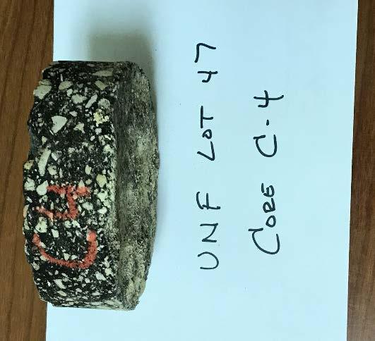
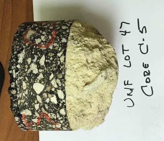
27 Core C-1 Core C-2 Core C-4 Core C-3 Core- C-5
REPORT OF GEOTECHNICAL EXPLORATION AND ENGINEERING ANALYSIS
 FIGURE 3 Geotechnical Report (2) REPORT OF GEOTECHNICAL EXPLORATION AND ENGINEERING ANALYSIS RIVER TOWER RESTORATION RIVER TOWER PARK TAMPA, FLORIDA AREHNA PROJECT NO. B-13-002 February 22, 2013 Prepared
Subsurface Investigation Report. Proposed New 1-Story Building 6447 Grand Avenue Gurnee, Illinois
 AGI Project No. -11 Subsurface Investigation Report For the Proposed New 1-Story Building 6447 Grand Avenue Gurnee, Illinois Prepared for Mr. Steve Panko Key Development Partners, LLC North State Street,
This report presents the findings of the subsurface exploration concerning the design of the taxiway rehabilitation. Description
 September 22, 2016 American Infrastructure Development, Inc. 3810 Northdale Boulevard, Suite 170 Tampa, Florida 33624 Attn: Mr. Mohsen Mohammadi, Ph.D., P.E. Senior Consultant Mob: (813) 244-6609 E-mail:
Site Location. Figure 1: Site Location Map US-24 and I-275 Interchange Ash Township, Monroe County, Michigan
 Site Location 0606 1771 North Dixie Highway Monroe, Michigan 48162 Tel: 734-289-2200 Fax: 734-289-2345 www.manniksmithgroup.com Figure 1: Site Location Map US-24 and I-275 Interchange Ash Township, Monroe
April 7, Webster Street Sub-Surface Stormwater Storage System Bid No Bid Date: 4/13/17 ADDENDUM NO 1
 PUBLIC WORKS DEPARTMENT David A. Jones, P.E., Director April 7, 2017 Webster Street Sub-Surface Stormwater Storage System Bid No. 2017-022 Bid Date: 4/13/17 ADDENDUM NO 1 Please make the following changes
Applied GeoScience, Inc Hammond Dr., Suite 6 Schaumburg, Illinois
 AGI Project No. 13-276 Subsurface Investigation Report For the Proposed New Retail Center 9601 South Pulaski Road Evergreen Park, Illinois Prepared for Mr. Feras Sweis FHS Design + Build LLC 2010 West
 FIGURES Printed By: aday Print Date: 3/23/2011 12:48:08 PM File Name: \\geodesign.local\files\jobs\m-r\penskeauto\penskeauto-1\penskeauto-1-01\figures\cad\penskeauto-1-01-vm01.dwg Layout: FIGURE 1 VICINITY
Ardaman & Associates, Inc. Geotechnical, Environmental and Materials Consultants
 SUBSURFACE SOIL EXPLORATION ANALYSIS AND RECOMMENDATIONS PROPOSED WEIRS AT STATIONS 130+00 AND 16+00 DRAINAGE IMPROVEMENTS TO THE FOUR CORNERS MSBU HENDRY COUNTY, FLORIDA Ardaman & Associates, Inc. Geotechnical,
Please include this addendum in your Bid proposal for the above referenced project. Questions are in black ink, and the answers are in red ink.
 JAHarchitects, LLC PROJECT NO. 393 RIVERCREST CDD 11560 RAMBLE CREEK DRIVE, RIVERVIEW FL ADDENDUM TO BID PROJECT: RIVERCREST CDD MULTI PURPOSE FIELD MAINTENANCE BUILDING & DOG PARK POOL & CABANNA JAH PROJECT
GEOTECHNICAL ENGINEERING REPORT
 GEOTECHNICAL ENGINEERING REPORT PROJECT MINECRAFT ACCESS ROAD BOYDTON PLANK ROAD DINWIDDIE COUNTY, VIRGINIA JOB NUMBER: 37775.003 PREPARED FOR: DINWIDDIE COUNTY PO BOX 70 DINWIDDIE COUNTY, STATE 23841
Geotechnical Engineering Report
 Geotechnical Engineering Report Pavement Subgrade Survey State Highway 125 over Hudson Creek Ottawa County, Oklahoma September 23, 21 Terracon Project No. 415121 Prepared for: Guy Engineering Services,
Subsurface Environmental Investigation
 Subsurface Environmental Investigation Lake Development East Lake and 21 st Avenue South February 23, 201 Terracon Project No. MP14738A Prepared for: Minneapolis Public Schools Prepared by: Terracon Consultants,
August 15, 2006 (Revised) July 3, 2006 Project No A
 July 3, 2006 Project No A") August 15, 2006 (Revised) July 3, 2006 Project No. 01-05-0854-101A Mr. David Reed, P.E. Protean Design Group 100 East Pine Street, Suite 306 Orlando, Florida 32801 Preliminary Soil Survey Report Polk Parkway
August 15, 2006 (Revised) July 3, 2006 Project No. 01-05-0854-101A Mr. David Reed, P.E. Protean Design Group 100 East Pine Street, Suite 306 Orlando, Florida 32801 Preliminary Soil Survey Report Polk Parkway
Geotechnical Engineering Report
 Geotechnical Engineering Report Turner Turnpike Widening Milepost 210 to 218 Drainage Structure Pipe Jacking Creek County, Oklahoma July 1, 2016 Terracon Project No. 04165017 Prepared for: Benham Tulsa,
Subsurface Investigation Report
 AGI Project No. 17-154 Subsurface Investigation Report For the Proposed New One-Story Building Addition 7030 West 111 th Street Worth, Illinois Prepared for T63 Development LLC 11052 Mayflow er Lane Orland
PARKING LOTS 4, 7, AND 8 RECONSTRUCTION REPORT
 PARKING LOTS 4, 7, AND 8 RECONSTRUCTION REPORT Converse Project No. 15-81-177-01 Prepared For: David Evans and Associates, Inc. 17782 17th Street, Suite 200 Tustin, California 92780 Prepared By: 10391
Prepared for: HDR Engineering, Inc. 200 West Forsyth Street, Suite 800 Jacksonville, Florida Prepared by:
 REPORT OF GEOTECHNICAL EXPLORATION REHABILITATE WHARF STRUCTURE AT BERTHS 6 AND ½ OF BERTH 5 TALLEYRAND MARINE TERMINAL, JACKSONVILLE, FLORIDA E&A PROJECT NO. 0756-0081 Prepared for: HDR Engineering, Inc.
GEOTECHNICAL INVESTIGATION I-15 SIGN BRIDGES LAS VEGAS EA JANUARY
 GEOTECHNICAL INVESTIGATION I-15 SIGN BRIDGES LAS VEGAS EA 73171 JANUARY 06 MATERIALS DIVISION STATE OF NEVADA DEPARTMENT OF TRANSPORTATION MATERIALS DIVISION GEOTECHNICAL SECTION GEOTECHNICAL REPORT I-15
GEOTECHNICAL STUDY PROPOSED CONCRETE ROADWAY TIKI ISLAND COMMUNITY GALVESTON COUNTY, TEXAS PROJECT NO E
 GEOTECHNICAL STUDY PROPOSED CONCRETE ROADWAY TIKI ISLAND COMMUNITY GALVESTON COUNTY, TEXAS PROJECT NO. 15-945E TO VILLAGE OF TIKI ISLAND TIKI ISLAND, TEXAS BY SERVICING TEXAS, LOUISIANA, NEW MEXICO, OKLAHOMA
APPENDIX A DRAINAGE STUDY PHASE 2 ALTERNATIVE IMPROVEMENTS CRYSTAL LAKE ALTERNATIVE 4C IMPROVEMENTS LAKEWOOD PIRATELAND SWASH HORRY COUNTY, SC
 DRAINAGE STUDY PHASE ALTERNATIVE IMPROVEMENTS CRYSTAL LAKE ALTERNATIVE C IMPROVEMENTS ` FOR: LAKEWOOD PIRATELAND SWASH HORRY COUNTY, SC APPENDIX A J-.000 Prepared by: Savannah, GA Charleston, SC Myrtle
Typical Subsurface Profile. November 28, 2016
 November 28, 2016 RSCCD Facility Planning, District Construction and Support Services 2323 N. Broadway, Suite 112, Santa Ana, CA 92706 Attn: Re: Ms. Allison Coburn Facilities Project Manager P: (714) 480-7530
Applied GeoScience, Inc Hammond Dr., Suite 6 Schaumburg, Illinois
 AGI Project No. 13-109B Subsurface Investigation Report For the Proposed Roosevelt Middle School Site Improvements 7560 Oak Avenue River Forest, Illinois Prepared for Mr. Jerry Pilipowicz Terra Engineering,
Earth Mechanics, Inc. Geotechnical & Earthquake Engineering
 Earth Mechanics, Inc. Geotechnical & Earthquake Engineering TECHNICAL MEMORANDUM DATE: June 3, 2009 EMI PROJECT NO: 01-143 TO: COPY: FROM: SUBJECT: John Chun, P.E. / Port of Long Beach (POLB) Jorge Castillo
Washtenaw Community College Design & Construction Facilities Management 4800 East Huron River Drive Ann Arbor, MI
 Washtenaw Community College Design & Construction Facilities Management 4800 East Huron River Drive Ann Arbor, MI 4810-4800 GEOTECHNICAL INVESTIGATION FOR Proposed Pavement Rehabilitation Parking Lots
SUBSURFACE EXPLORATION & GEOTECHNICAL ENGINEERING EVALUATION
 Report of Subsurface Exploration and Geotechnical Engineering Evaluation Proposed Courtyard Marriott Phenix City, Alabama BHATE Project Number: 112263 October 9, 2012 SUBSURFACE EXPLORATION & GEOTECHNICAL
Geotechnical Investigation Report
 MC Squared, Inc. Geotechnical Investigation Report City of St. Petersburg Forcemain Pinellas County, Florida Prepared for: Hazen and Sawyer 10002. Princess Palm Ave., Suite 200 Tampa, Florida 33610 Prepared
SUBSURFACE INVESTIGATION, LABORATORY TESTING PROGRAM, AND PAVEMENT RECOMMENDATIONS
 February 7, 2017 EDR Architects, PLLC PO Box 271613 Corpus Christi, TX 78427 Attention: Ms. Emily D. Rozypal, AIA SUBJECT: SUBSURFACE INVESTIGATION, LABORATORY TESTING PROGRAM, AND PAVEMENT RECOMMENDATIONS
GEOTECHNICAL REPORT B-1942
 GEOTECHNICAL REPORT TUSCARORA BRIDGE REPLACEMENT B-1942 E.A. 73561 March 2011 MATERIALS DIVISION STATE OF NEVADA DEPARTMENT OF TRANSPORTATION MATERIALS DIVISION GEOTECHNICAL SECTION GEOTECHNICAL REPORT
REPORT OF SUBSURFACE EXPLORATION AND GEOTECHNICAL ANALYSIS DMA TAMPA RED BRICK BUILDING TAMPA, FLORIDA FOR MRI ARCHITECTURAL GROUP, INC.
 REPORT OF SUBSURFACE EXPLORATION AND GEOTECHNICAL ANALYSIS DMA TAMPA RED BRICK BUILDING TAMPA, FLORIDA FOR MRI ARCHITECTURAL GROUP, INC. JANUARY 7, 2015 January 7, 2015 Mr. Pete Ikegami MRI Architectural
Geotechnical Engineering Report
 Geotechnical Engineering Report Shaw AFB East Gate Entrance Control Facility Amendment Sumter, South Carolina September 13, 2010 Terracon Project No. 73105020A Prepared for: TranSystems North Charleston,
REPORT OF SUBSURFACE EXPLORATION AND GEOTECHNICAL ENGINEERING SERVICES
 REPORT OF SUBSURFACE EXPLORATION AND GEOTECHNICAL ENGINEERING SERVICES NORTH SHORE SCHOOL DISTRICT 11 HIGHLAND PARK, ILLINOIS ECS PROJECT NO. 1:8 FOR NORTH SHORE SCHOOL DISTRICT 11 SEPTEMBER, 1 REPORT
Geotechnical Engineering Report South Shore Carter Lake Campground Expansion Northwest of CR 31 and Cougar Run Lane Larimer County, Colorado
 Geotechnical Engineering Report South Shore Carter Lake Campground Expansion Northwest of CR 31 and Cougar Run Lane Larimer County, Colorado July 15, 2016 Terracon Project No. 20165057 Prepared for: Larimer
SOIL MECHANICS Assignment #2: Soil Classification Solution.
 Geotechnical Engineering Research Laboratory One University Avenue Lowell, Massachusetts 01854 Edward L. Hajduk, D.Eng, PE Lecturer PA105D Tel: (978) 934 2621 Fax: (978) 934 3052 e mail: Edward_Hajduk@uml.edu
GEOTEK ENGINEERING & TESTING SERVICES, INC. 909 East 50 th Street North Sioux Falls, South Dakota Phone Fax
 GEOTEK ENGINEERING & TESTING SERVICES, INC. 909 East 50 th Street North Sioux Falls, South Dakota 57104 Phone 605-335-5512 Fax 605-335-0773 October 28, 2016 City of Vermillion 25 Center Street 57069 Attn:
SECTION XXXXX AGGREGATE PIERS PART 1 - GENERAL
 SECTION XXXXX AGGREGATE PIERS PART 1 - GENERAL 1.1 RELATED DOCUMENTS: Drawings and general provisions of the Contract, including General and Supplementary Conditions and other Division 00 and Division
Geotechnical Testing Laboratory, Inc. Engineering and Construction Materials Testing Services
 Engineering and Construction Materials Testing Services February 27, 15 Central Louisiana Economic and Development Alliance P.O. Box 465 Alexandria, Louisiana 719 Attention: Mr. Rick Ranson Vice President
REPORT OF SUBSURFACE INVESTIGATION AND GEOTECHNICAL ENGINEERING SERVICES
 REPORT OF SUBSURFACE INVESTIGATION AND GEOTECHNICAL ENGINEERING SERVICES Elizabeth City, North Carolina G E T Project No: EC14-188G May 30, 2014 PREPARED FOR: 106 Capital Trace, Unit E Elizabeth City,
You also requested information regarding a sieve analysis at each boring locations. The test results are attached.
 FORENSICS CONSULTANTS ENVIRONMENTAL GEOTECHNICAL MATERIALS October 4, 2016 Washington County Public Works 11660 Myeron Road Stillwater, MN 55082 Attn: Mr. Marc Briese Re: Additional Borings CSAH 22 (70
SECTION EXCAVATION AND EMBANKMENT. B. Subbase Grading A samples for gradation analysis.
 PART 1 GENERAL 1.1 DESCRIPTION A. The WORK under this Section includes providing all labor, materials, tools and equipment necessary for excavation and embankment construction to the lines, grades and
GEOTECHNICAL INVESTIGATION MDACC GUHN ROAD FLOOD MITIGATION PROJECT 5610 GUHN ROAD HOUSTON, TEXAS REPORT NO
 GEOTECHNICAL INVESTIGATION MDACC GUHN ROAD FLOOD MITIGATION PROJECT 5610 GUHN ROAD HOUSTON, TEXAS REPORT NO. 1140189301 Reported to: URS CORPORATION Houston, Texas Reported by: GEOTEST ENGINEERING, INC.
REPORT OF SUBSURFACE EXPLORATION
 REPORT OF SUBSURFACE EXPLORATION WELDING & JOINING TECHNOLOGY FACILITY NORTH GEORGIA TECHNICAL COLLEGE CLARKESVILLE, GEORGIA S&ME PROJECT NO. 161-10-061 Prepared For: LW Engineering, P.C. Post Office Box
SOILS INVESTIGATION REPORT The Sorrento Apartments Hobbs, New Mexico
 SOILS INVESTIGATION REPORT The Sorrento Apartments Hobbs, New Mexico PREPARED FOR: Ted Trout Architect & Associates, LTD. Attn: Cesar Corrales 6363 Woodway Suite 00 Houston, TX 7707 Debra P. Hicks, PE/LSI
PRELIMINARY ENGINEERING DESIGN MEMORANDUM WATER TREATMENT PLANT FLOOD WALL TO PROTECT BACKWASH SETTLING BASIN CITY OF NEW BUFFALO, MI
 PRELIMINARY ENGINEERING DESIGN MEMORANDUM WATER TREATMENT PLANT FLOOD WALL TO PROTECT BACKWASH SETTLING BASIN CITY OF NEW BUFFALO, MI City of New Buffalo, MI Preliminary Engineering Design Memorandum Water
GEOTECHNICAL STUDY HIDDEN VALLEY SPORTS PARK RESTROOM FACILITY MABEL JONES DRIVE CANYON LAKE, TEXAS
 FUGRO CONSULTANTS, INC. GEOTECHNICAL STUDY HIDDEN VALLEY SPORTS PARK RESTROOM FACILITY MABEL JONES DRIVE CANYON LAKE, TEXAS COMAL COUNTY Canyon Lake, Texas GEOTECHNICAL STUDY HIDDEN VALLEY SPORTS PARK
File No Supplemental November Geotechnical and Environmental Consulting Engineers
 Supplemental Information & Geotechnical Recommendations Proposed New Solar Valley Location B (East of Building No. 7) Cañada Community College 4200 Farm Hill Boulevard Submitted to: Mr. Peter Hempel Construction
Geotechnical Engineering Report
 Geotechnical Engineering Report Foothills Drive Widening Holmes Drive to Lakewood Street Farmington, New Mexico April 9, 2014 Terracon Project No. 69135010 Prepared for: Souder Miller & Associates Farmington,
SUBSURFACE EXPLORATION AND GEOTECHNICAL ENGINEERING REPORT MMS OFFICE BUILDING OLATHE, KS PREPARED FOR
 1308 Adams I Kansas City, Kansas 66103 913.321.8100 I kctesting.com Su SUBSURFACE EXPLORATION AND GEOTECHNICAL ENGINEERING REPORT MMS OFFICE BUILDING OLATHE, KS PREPARED FOR Mr. Chris Herre, AIA Rose Design
MAPLES COMMUNITY CENTRE ADDITION GEOTECHNICAL INVESTIGATION 434 ADSUM DRIVE WINNIPEG, MANITOBA
 MAPLES COMMUNITY CENTRE ADDITION GEOTECHNICAL INVESTIGATION 434 ADSUM DRIVE WINNIPEG, MANITOBA Prepared for: Maples Recreation Association c / o Wolfrom Engineering Ltd. Winnipeg, Manitoba February 2014
SECTION TRENCHING & BACKFILLING
 SECTION 02225 - TRENCHING & BACKFILLING 1.0 GENERAL 1.1 Work included in this Section includes trenching and backfilling for underground pipelines and related structures only. 1.2 Reference Specifications
Preliminary Geotechnical Exploration Armstrong Tract Rivers Avenue and Hanahan Road North Charleston, South Carolina S&ME Project No.
 Preliminary Geotechnical Exploration Rivers Avenue and Hanahan Road S&ME Project No. 4213-16-016 Prepared for: Charleston Water System 103 Saint Phillip Street Charleston, South Carolina 29403 Prepared
Report of Preliminary Geotechnical Engineering Investigation for Ponds
 Report of Preliminary Geotechnical Engineering Investigation for Ponds Segment 2: State Road 400 (SR 400)/Interstate 4 (I-4) from West of SR 528 (Beachline Expressway) to West of SR 435 (Kirkman Road)
B. Subsurface data is available from the Owner. Contractor is urged to carefully analyze the site conditions.
 SECTION 31 23 33 - TRENCHING, BACKFILLING AND COMPACTION PART 1 - GENERAL 1.1 SCOPE A. This Section specifies the requirements for excavating and backfilling for storm sewer, sanitary sewer, water distribution
Memorandum. FOUNDATION ENGINEERING, INC. Professional Geotechnical Services. Date: August 13, 2012 To:
 FOUNDATION ENGINEERING, INC. Professional Geotechnical Services Memorandum Date: August 13, 2012 To: From: Subject: Project: Brett C. Martin, P.E. LEI Engineering & Surveying, LLC James K. Maitland, P.E.,
FORT ROUGE GLASS GEOTECHNICAL INVESTIGATION SOUTH LANDING BUSINESS PARK. RM of MacDONALD, MANITOBA
 FORT ROUGE GLASS GEOTECHNICAL INVESTIGATION SOUTH LANDING BUSINESS PARK RM of MacDONALD, MANITOBA Prepared for: Berntt Holdings Ltd. Winnipeg, Manitoba October 2016 File #163984 Table of Contents 1.0
ENGINEERING SERVICES REPORT FOREST LAKES BOULEVARD PAVEMENT EVALUATION TAMPA ROAD TO COUNTY LINE FOR PINELLAS COUNTY, FL. May 21, 2010 URS CORPORATION
 ENGINEERING SERVICES REPORT FOREST LAKES BOULEVARD PAVEMENT EVALUATION TAMPA ROAD TO COUNTY LINE FOR PINELLAS COUNTY, FL May 21, 2010 URS CORPORATION May 21, 2010 Mr. Brent D. Hall Senior Department Administrative
geotechnical and construction materials consultants
 geotechnical and construction materials consultants City of Dallas Public Works and Transportation Department 320 E. Jefferson Blvd, Room 307 Dallas, Texas 75203 ATTN: Mr. Vincent Lewis, P.E. Email: Vincent.lewis@dallascityhall.com
GEOTECHNICAL EXPLORATION REPORT. For the. Project ID: th Avenue Vogt Drive to Decorah Road Local Street Washington County.
 GEOTECHNICAL EXPLORATION REPORT For the Project ID: 277--9 18 th Avenue Vogt Drive to Decorah Road Local Street Washington County Prepared for: Alfred Benesch & Company 1 West Canal Street, Suite 15 Milwaukee,
Subsurface Investigation and Geotechnical Analysis Target Outparcel Midlothian Turnpike Richmond, Virginia. Client: Interface Properties
 Subsurface Investigation and Geotechnical Analysis Target Outparcel 11309 Midlothian Turnpike Richmond, Virginia Client: Interface Properties December 5, 2017 December 5, 2017 The Heritage Group, LLC Attn:
GENERAL SOILS EVALUATION REPORT. For
 GENERAL SOILS EVALUATION REPORT For EPWU PROPOSED KENTUCKY DAM (DAM 5) DRAINAGE SYSTEM IMPROVEMENTS KENTUCKY ST. & ALABAMA ST. EL PASO, EL PASO COUNTY, TEXAS Prepared For MORENO CARDENAS INC. 2505 E. MISSOURI
August 17, DCN Number: ALB07WP001 Revision: 0. Prepared By: 8300 Jefferson NE Suite B Albuquerque, New Mexico 87113
 WORK PLAN ENERGY FUELS RESOURCE CORPORATION URANIUM MILL LICENSING SUPPORT PHASE 1 GEOTECHNICAL INVESTIGATION KLEINFELDER PROJECT NO. 83088 August 17, 2007 DCN Number: 83088.1.4.2-ALB07WP001 Revision:
SUBSURFACE EXPLORATION, LABORATORY TESTING PROGRAM, AND FOUNDATION AND PAVEMENT RECOMMENDATIONS
 GEOTECHNICAL ENGINEERING CONSTRUCTION MATERIALS ENGINEERING & TESTING SOILS ASPHALT CONCRETE Elsasser Architectural Inc. P.O. Box 833 Georgetown, Texas 78627 Attention: Richard Elsasser relsasser@eai-tx.com
Addendum 1 - Appendix A - 1 of 22
 Addendum 1 - Appendix A - 1 of 22 Erdman Anthony of Florida, Inc. August 1, 2007 1402 Royal Palm Beach Boulevard Building 500 Royal Palm Beach, Florida 33411 Attention: Subject: Ms. Dana I. Gillette, P.E.,
REPORT ON GEOTECHNICAL INVESTIGATION 1251 MAIN STREET NORTH. STITTSVILLE, ONTARIO REPORT NO.: G-CPR-A REPORT DATE: SEPTEMBER 24, 2015
 REPORT ON GEOTECHNICA INVETIGATION 1251 MAIN TREET NORTH. TITTVIE, ONTARIO REPORT NO.: 4186-15-G-CPR-A REPORT DATE: EPTEMBER 24, 2015 PREPARED FOR CHOICE PROPERTIE REIT 22 T. CAIR AVENUE EAT TORONTO, ONTARIO
SECTION RIPRAP, BOULDERS, AND BEDDING
 SECTION 31 37 00 RIPRAP, BOULDERS, AND BEDDING PART 1 GENERAL 1.01 SECTION INCLUDES A. The WORK includes excavation, grading, and installation of riprap, boulders, soil riprap, void-filled riprap, and
REPORT. Explorations and Geotechnical Engineering Services. Proposed Seaport Village Healthcare Facility Ellsworth, Maine. March 27, S
 REPORT March 27, 2013 S Explorations and Geotechnical Engineering Services Proposed Seaport Village Healthcare Facility Ellsworth, Maine PREPARED FOR: First Atlantic Corporation Attention: Craig Coffin,
GEOTECHNICAL STUDY NEW CONSTRUCTION AT THE WESTFALL APARTMENTS VISTA DEL SOL DRIVE EL PASO, EL PASO COUNTY, TEXAS
 GEOTECHNICAL STUDY NEW CONSTRUCTION AT THE WESTFALL APARTMENTS 10661 VISTA DEL SOL DRIVE EL PASO, EL PASO COUNTY, TEXAS Amec Foster Wheeler Project No. 1637192025 Submitted To: 101. S. Jennings Avenue,
Utility Cut Restoration
 Design Manual Chapter 9 - Utilities 9D - Utility Cut Restoration 9D-1 Utility Cut Restoration A. General Utility cuts are made in existing pavement sections to install a myriad of utilities and to repair
TRENCH EXCAVATION AND BACKFILL
 SUDAS Standard Specifications Division 3 - Trench and Trenchless Construction Section 300 - Trench Excavation and Backfill TRENCH EXCAVATION AND BACKFILL PART - GENERAL.0 SECTION INCLUDES A. Trench Excavation
Report of Geotechnical Engineering Investigation OIA SOUTH CELL LOT (W340) AID Project No. GOA16001 Orange County, Florida GEC Project No.
 AID Project No. GOA16001 Orange County, Florida GEC Project No.") Report of Geotechnical Engineering Investigation OIA SOUTH CELL LOT (W40) AID Project No. GOA16001 Orange County, Florida GEC Project No. 956G July 6, 2017 American Infrastructure Development, Inc. 7 North
Report of Geotechnical Engineering Investigation OIA SOUTH CELL LOT (W40) AID Project No. GOA16001 Orange County, Florida GEC Project No. 956G July 6, 2017 American Infrastructure Development, Inc. 7 North
PROJECT NO A. ISSUED: February 29, 2016
 INTERPRETIVE REPORT FOR INFILTRATION SYSTEM DESIGN, PROPOSED VILLA VERONA APARTMENT COMMUNITY, ASSESSOR S PARCEL NUMBERS 311-040-015, 311-040-021, 311-040-024, 311-040-026 AND 311-040-013, LOCATED ON THE
SECTION AGGREGATES
 SECTION 32 05 00 AGGREGATES PART 1 GENERAL 1.01 SUMMARY A. Section Includes: 1. Aggregate base 2. Engineered fill 3. Backfill 4. Fine filter aggregate (non-frost susceptible fill) 5. Riprap 6. Recreational
SECTION VIII GEOTECHNICAL ENGINEERING REPORT
 SECTION VIII GEOTECHNICAL ENGINEERING REPORT Copyright 2014 GFAC ENGINEERING INC. Page i of vi July 31, 2014 GEOTECHNICAL ENGINEERING REPORT PROPOSED SUBDIVISION STREETS AND DETENTION BASIN WEST SILOAM
EXCAVATION & BACKFILLING GUELPH TRANSIT OPERATIONS & MAINTENANCE SECTION WATSON ROAD FACILITY PAGE 1 OF 6 WATER RECLAMATION PROJECT JUNE 2013
 GUELPH TRANSIT OPERATIONS & MAINTENANCE SECTION WATSON ROAD FACILITY PAGE 1 OF 6 PART 1 GENERAL 1.1 Description The Work of this Section shall be all labour, materials, equipment and supervision necessary
Report of Geotechnical Study
 Report of Geotechnical Study Baltimore Sun Consolidation Baltimore, Maryland F&R Project No. 75V0084 Prepared For: 901 Dulaney Valley Road, Suite 801 Towson, MD 21204 Prepared By: Froehling & Robertson,
SITE INVESTIGATION Validation and Interpretation of data
 SITE INVESTIGATION Validation and Interpretation of data Dr. G.Venkatappa Rao The Impact 1 The Need To determine the type of foundation To assess bearing capacity/settlement Location of Ground water table,issues
BUILDING ADDITION Hurlburt Field AFB, Okaloosa County, Florida
 REPORT OF SUBSURFACE EXPLORATION AND GEOTECHNICAL ENGINEERING EVALUATION BUILDING 90020 ADDITION Hurlburt Field AFB, Okaloosa County, Florida Prepared For: CALDWELL ASSOCIATES ARCHITECTS, INC. 116 North
CHAPTER 7 PAVEMENT DESIGN. 1. Gradation (sieve and hydrometer analysis) 3. Moisture density relationships and curves
 3. Moisture density relationships and curves") CHAPTER 7 PAVEMENT DESIGN 7.0 GENERAL The purpose of this chapter is to define the requirements for design of pavement within proposed and existing roadways for new subdivision streets and secondary roads.
CHAPTER 7 PAVEMENT DESIGN 7.0 GENERAL The purpose of this chapter is to define the requirements for design of pavement within proposed and existing roadways for new subdivision streets and secondary roads.
Amendment 03 Soils Report. At Air Academy High School 6910 Carlton Drive Colorado Springs, CO 80840
 Amendment 03 Soils Report Issued: November 7, 2017 For RFP 18-KG-0928(BF) Design/Build Services for New Synthetic Turf Field At Air Academy High School 6910 Carlton Drive Colorado Springs, CO 80840 Academy
November 13, IP3406. Mr. Uriah Sowell Rooney Engineering 115 Inverness Drive East, Suite 300, Englewood, CO 80112
 November 13, 2015 103IP3406 Mr. Uriah Sowell Rooney Engineering 115 Inverness Drive East, Suite 300, Englewood, CO 80112 Subject: Infiltration Testing Hopeland Road Valve Site Sunoco Pennsylvania Pipeline
SCG INTERNATIONAL TRINIDAD AND TOBAGO LIMITED COUVA CHILDREN S HOSPITAL
 SCG INTERNATIONAL TRINIDAD AND TOBAGO LIMITED COUVA CHILDREN S HOSPITAL GEOTECHNICAL CONSULTANT Prepared by Checked by Approved by Mr. C Allen Dr. Derek Gay Dr. Derek Gay Signature Date Signature Date
GENERAL SOILS EVALUATION REPORT. For
 GENERAL SOILS EVALUATION REPORT For EL PASO WATER UTILITIES (EPWU) PROPOSED AUSTIN STORMWATER POND IMPROVEMENTS NE OF ALTURA AVE. & LACKLAND ST. EL PASO, EL PASO COUNTY, TEXAS Prepared For MORENO CARDENAS
November 13, IP3406. Mr. Uriah Sowell Rooney Engineering 115 Inverness Drive East, Suite 300, Englewood, CO 80112
 November 13, 2015 103IP3406 Mr. Uriah Sowell Rooney Engineering 115 Inverness Drive East, Suite 300, Englewood, CO 80112 Subject: Infiltration Testing Gates Road Valve Site Sunoco Pennsylvania Pipeline
Consultant Specifications for Subsurface Investigation & Geotechnical Analysis and Design Recommendations
 Consultant Specifications for Subsurface Investigation & Geotechnical Analysis and Design Recommendations Mn/DOT Geotechnical Section - Office of Materials & Road Research http://www.mrr.dot.state.mn.us/geotechnical/foundations/tcontract.asp
BUILDING DEVELOPMENT POLICIES AND PROCEDURES ADMINISTRATIVE/GENERAL
 GEOTECHNICAL GUIDELINES FOR THE USE OF LIME DURING CONSTRUCTION Section Page 4-0X0l Applicability and Restrictions 2 4-0X02 Expansive Soil Determination 5 4-0X03 Mixture Design for Lime Stabilization of
SPECIFICATIONS FOR PRECAST MODULAR BLOCK RETAINING WALL SYSTEM (revised 5/8/7)
") Page 1 of 7 STONE STRONG SYSTEMS SPECIFICATIONS FOR PRECAST MODULAR BLOCK RETAINING WALL SYSTEM (revised 5/8/7) PART 1: GENERAL 1.01 Description A. Work includes furnishing and installing precast modular
Page 1 of 7 STONE STRONG SYSTEMS SPECIFICATIONS FOR PRECAST MODULAR BLOCK RETAINING WALL SYSTEM (revised 5/8/7) PART 1: GENERAL 1.01 Description A. Work includes furnishing and installing precast modular
REPORT OF SUBSURFACE INVESTIGATION AND GEOTECHNICAL ENGINEERING SERVICES. Proposed Soundside Boardwalk Expansion Duck, North Carolina
 REPORT OF SUBSURFACE INVESTIGATION AND GEOTECHNICAL ENGINEERING SERVICES Proposed Soundside Boardwalk Expansion Duck, North Carolina G E T PROJECT NO: EC10-260G November 17, 2010 Prepared for VHB, Inc.
LEVELTON CONSULTANTS LTD. 1.0 Introduction. 2.0 Project Description. December 16, Levelton File # R
 LEVELTON CONSULTANTS LTD. Abbotsford Office 110-34077 Gladys Avenue Abbotsford, BC V2S 2E8 T: 604.855.0206 F: 604.853.1186 abbotsford@levelton.com www.levelton.com December 16, 2015 Levelton File # R715-1604-00
Recommended Mix Design Guidelines For Cold Recycling Using Foamed (Expanded) Asphalt Recycling Agent CR202
 Asphalt Recycling Agent CR202") Recommended Mix Design Guidelines For Cold Recycling Using Foamed (Expanded) Asphalt Recycling Agent CR202 8/25/2017 NOTICE It is not intended or recommended that these guidelines be used verbatim within
Recommended Mix Design Guidelines For Cold Recycling Using Foamed (Expanded) Asphalt Recycling Agent CR202 8/25/2017 NOTICE It is not intended or recommended that these guidelines be used verbatim within
Rock Creek Apartments Wheatland, WY
 Subsurface Exploration and Geotechnical Engineering Report Prepared for: Rock Creek Apartments, LLC C/O Blue Line Development 1004 South Ave West Missoula, MT 59801 Rock Creek Apartments Wheatland, WY
SECTION Stabilizer Apache Warning Track Mix for baseball or softball field surfacing
 Stabilizer Solutions, Inc. 33 S. 28 th St. Phoenix, AZ 85034 800-336-2468 (Fax) 602-225-5902 Website: stabilizersolutions.com E-Mail: info@stabilizersolutions.com SECTION 1 STABILIZER APACHE WARNING TRACK
PRELIMINARY GEOTECHNICAL INVESTIGATION UCCS PARKING GARAGE STANTON STREET AND AUSTIN BLUFFS PARKWAY COLORADO SPRINGS, COLORADO
 PRELIMINARY GEOTECHNICAL INVESTIGATION UCCS PARKING GARAGE STANTON STREET AND AUSTIN BLUFFS PARKWAY COLORADO SPRINGS, COLORADO Prepared for: UNIVERSITY OF COLORADO AT COLORADO SPRINGS Facilities Services
ACKNOWLEDGMENT OF SPONSORSHIP
 ACKNOWLEDGMENT OF SPONSORSHIP This work was sponsored by the American Association of State Highway and Transportation Officials, in cooperation with the Federal Highway Administration, and was conducted
A. Texas Department Transportation 2004 Standard Specifications for Construction of Highways, Streets and Bridges (TxDOT):
:") SECTION 31 32 13.16 CEMENT STABILIZATION PART 1 GENERAL 1.1 SCOPE OF WORK A. This Section pertains to the specifications for cement stabilization of sandy or silty soil and consists of pulverizing, addition
SECTION 31 32 13.16 CEMENT STABILIZATION PART 1 GENERAL 1.1 SCOPE OF WORK A. This Section pertains to the specifications for cement stabilization of sandy or silty soil and consists of pulverizing, addition
GEOTECHNICAL ENGINEERING REPORT SUBSTATION NO. 3 PRYOR, OKLAHOMA. Prepared for: FINLEY ENGINEERING P.O. Box 148 Lamar, Missouri
 GEOTECHNICAL ENGINEERING REPORT SUBSTATION NO. 3 PRYOR, OKLAHOMA Prepared for: FINLEY ENGINEERING P.O. Box 148 Lamar, Missouri 64759 Prepared by: Geotechnical Services Environmental Services Material Testing
REPORT OF SUBSURFACE EXPLORATION AND GEOTECHNICAL ENGINEERING ANALYSIS
 REPORT OF SUBSURFACE EXPLORATION AND GEOTECHNICAL ENGINEERING ANALYSIS HADENSVILLE FIRE STATION # THREE CHOPT ROAD AND OLD FREDERICKSBURG ROAD GOOCHLAND COUNTY, VIRGINIA FOR Mr. Josh Bennett Moseley Architects,
Minimum Guidelines for the Design and Use of Underpins When Performing Foundation Stabilization and/or Supplementation UP-08
 Minimum Guidelines for the Design and Use of Underpins When Performing Foundation Stabilization and/or Supplementation UP-08 Table of Contents 1. Title 2. Designation 3. List of Figures 4. Scope 5. Referenced
REPORT OF SUBSURFACE EXPLORATION AND GEOTECHNICAL ENGINEERING EVALUATION. Panama City, Bay County, Florida
 REPORT OF SUBSURFACE EXPLORATION AND GEOTECHNICAL ENGINEERING EVALUATION PANAMA CITY MARINA LIGHTHOUSE Panama City, Bay County, Florida Prepared For: PANAMA CITY CRA 803 JENKS AVENUE,SUITE 1 PANAMA CITY,BAY
STANDARD SPECIFICATIONS SECTION PAVEMENT REQUIREMENTS
 STANDARD SPECIFICATIONS SECTION 02950 PAVEMENT REQUIREMENTS PART 1 GENERAL 1.1 DESCRIPTION A. Section includes requirements for removing, replacing and providing new paving for roads, driveways, parking
Subsurface Exploration and Foundation Analysis Proposed New Weight Room / Fieldhouse Building 429 N Highway 83 Leakey, Texas
 Subsurface Exploration and Foundation Analysis Proposed New Weight Room / Fieldhouse Building 429 N Highway 83 Leakey, Texas InTEC Project No. S161639 April 18, 2016 Leakey ISD P.O. Box 1129 Leakey, Texas
is a possibility of the existence of permafrost as a result
 111.2 CERTAIN ASPECTS OF ALASKA DISTRICT ENGINEERS EXPERIENCE IN AREAS OF MARGINAL PERMAFROST E. L. Long In nearly twenty years of engineering and construction experience in Alaska, the Alaska District