Geotechnical Engineering Report
|
|
|
- Charleen George
- 6 years ago
- Views:
Transcription

1 Geotechnical Engineering Report Shaw AFB East Gate Entrance Control Facility Amendment Sumter, South Carolina September 13, 2010 Terracon Project No A Prepared for: TranSystems North Charleston, South Carolina Prepared by: Terracon Consultants, Inc. Columbia, South Carolina


2 September 13, 2010 TranSystems 4390 Belle Oaks Drive, Suite 220 North Charleston, SC Attn: Re: Mr. John Collins Geotechnical Engineering Report Shaw AFB East Gate Entrance Control Facility Amendment Sumter, South Carolina Terracon Project No A Dear Mr. Collins: Terracon Consultants, Inc. (Terracon) has completed the geotechnical engineering services for the above referenced project. This study was performed in general accordance with our Proposal No. P , dated June 23, The purpose of this exploration was to obtain information on the subsurface conditions at the proposed project site, perform laboratory testing on soil samples obtained from the site and provide our client with a summary of the field testing, boring data, laboratory test data and site description. We appreciate the opportunity to be of service to you on this project. Materials testing services are provided by Terracon. We would be pleased to discuss these services with you. If you have any questions concerning this report, or if we may be of further service, please contact us. Sincerely, Terracon Consultants, Inc. Ahmed Zein, Ph.D., P.E. Project Engineer Phillip A. Morrison, P.E. Geotechnical Department Manager SC Registration No Attachments 3xc: Client 1xc: File Terracon Consultants, Inc. 521 Clemson Road Columbia, South Carolina P [803] F [803] terracon.com
3 TABLE OF CONTENTS Page 1.0 INTRODUCTION SITE LOCATION AND DESCRIPTION SUBSURFACE CONDITIONS Geology Typical Subsurface Profile Groundwater Conditions LABORATORY TESTING GENERAL COMMENTS... 3 APPENDIX A Field Exploration Site Location Map Boring Location Plan Boring Logs DCP Data Sheet Field Testing Description APPENDIX B Laboratory Test Data Laboratory Testing Description Laboratory Data Sheets Summary of Laboratory Test Results APPENDIX C Supporting Documents General Notes Unified Soil Classification System
4 REPORT OF GEOTECHNICAL EXPLORATION SHAW AFB EAST GATE ENTRANCE CONTROL FACILITY AMENDMENT SUMTER, SOUTH CAROLINA 1.0 INTRODUCTION Terracon Project No A September 13, 2010 Our geotechnical engineering scope of work for this project included the advancement of three soil test borings to a depth of 10 feet below existing site grades, performance of one Dynamic Cone Penetration (DCP) test in an existing paved area to a depth of 3 feet below the pavement surface and performance of laboratory testing on select soil samples. At the request of our client, our scope of work did not include providing engineering recommendations for the planned construction. Logs of the borings and other field tests along with a Site Location Map and a Boring Location Plan are included in Appendix A of this report. The results of the laboratory testing performed on soil samples obtained from the site during the field exploration are included in Appendix B of this report. Descriptions of the field exploration and laboratory testing are included in their respective appendices. Terracon had previously prepared the geotechnical engineering report for this project (Terracon Report No , dated April 27, 2010). Our previous geotechnical engineering scope of work included drilling of six soil test borings, performance of six DCP tests and performance of geophysical (ReMi) testing. The purpose of the previous exploration was to obtain information on the subsurface conditions at the proposed project site and, based on this information, provide recommendations regarding the design and construction of foundations and floor slabs for the new gatehouse and overwatch building. The current study is considered an addendum to that report. As such, all limitations and recommendations associated with that report apply to this document. 2.0 SITE LOCATION AND DESCRIPTION ITEM Location Existing development Current ground cover DESCRIPTION The areas north and east of the existing contractor s entrance guard house within the southeast extreme of Shaw AFB near Sumter, South Carolina. The project area is primarily undeveloped. Asphalt paving and grass. Reliable Responsive Convenient Innovative 1
5 Geotechnical Engineering Report East Gate Entrance Control Facility Amendment Sumter, South Carolina September 13, 2010 Terracon Project No A ITEM Existing topography Existing Utilities DESCRIPTION In general, the site grades slightly slope up toward the north. Based on the provided topographic site plan, the site grades range from Elevation 206 feet on the south side (vicinity of Boring CBR-7) to Elevation 209 feet on the north side of the site (vicinity of Boring CBR-9). No underground utilities were marked at the site by the public utility locators. 3.0 SUBSURFACE CONDITIONS 3.1 Geology The site is located in the upper Coastal Plain physiographic province of South Carolina. The Coastal Plain is a wedge-shaped cross-section of water and wind deposited soil. Its thickness ranges from a featheredge at the surface contact of the Piedmont (Fall Line) to several thousand feet at the present day coastline. The sediments range in age from the Cretaceous and Tertiary periods at the contact with the bedrock to the recent period at the present coastline. The sediments include clays, silts, sands, and gravels, as well as organics. 3.2 Typical Subsurface Profile Specific conditions encountered at each boring location are indicated on the individual boring logs. Stratification boundaries on the boring logs represent the approximate location of changes in soil types; in-situ, the transition between materials may be gradual. Details for each of the borings can be found on the boring logs included in Appendix A of this report. Based on the results of the borings, subsurface conditions on the project site can be generalized as follows: Description Surface Treatments Approximate Depth to Bottom of Stratum (feet) 3 inches / 6 inches in Boring CBR-9 1 to 3 inches in Borings CBR-7 and CBR-8 Stratum 1 10 Material Encountered Consistency/Density Asphalt / Stone Base - Topsoil - Coastal Plain sand, clayey sand and silty sand Loose to medium dense One DCP test was performed to a depth of 3 feet below the pavement surface in Boring CBR-9. Based on the test results, the subsurface soils at this location have CBR values ranging from 22 to 100 percent. We note that these values are higher than the laboratory CBR values (see Section 4). These values were measure in dry conditions, whereas laboratory CBR testing is performed on soaked soils. Reliable Responsive Convenient Innovative 2
6 Geotechnical Engineering Report East Gate Entrance Control Facility Amendment Sumter, South Carolina September 13, 2010 Terracon Project No A 3.3 Groundwater Conditions Groundwater was not encountered by the borings during the field exploration. These observations represent conditions at the time of the field exploration and may not be indicative of other times, or at other locations. Groundwater conditions can change with varying seasonal and weather conditions, and other factors. The possibility of groundwater fluctuations should be considered when developing design and construction plans for the project. 4.0 LABORATORY TESTING The samples were classified in the laboratory based on visual observation, texture and plasticity. The soil descriptions indicated on the boring logs are in accordance with the enclosed the Unified Soil Classification System (USCS). Our laboratory testing program consisted of performing water content, mechanical gradations and fines content (percent of silt and clay) tests on selected soil samples. Results of these tests are provided on the boring logs and the Summary of Laboratory Results found in Appendix B. Two (2) California Bearing Ratio (CBR) tests were performed on bulk samples obtained from borings drilled in grassed areas (Borings CBR-7 and CBR-8). The samples were obtained from below the topsoil layer to a depth of about 5 feet below the ground surface. The test results for the standard Proctor testing and the CBR test results (compacted to 100 percent of the standard Proctor value are summarized in the table below. BORING STANDARD PROCTOR MAXIMUM DRY UNIT WEIGHT, PCF STANDARD PROCTOR OPTIMUM WATER CONTENT, % CBR VALUE IN. 0.2 IN. CBR CBR CBRs compacted to 100 percent of the standard Proctor maximum dry unit weight. 5.0 GENERAL COMMENTS This report does not reflect variations that may occur between borings, across the site, or due to the modifying effects of weather. The nature and extent of such variations may not become evident until during or after construction. If variations appear, we should be immediately notified so that further evaluation can be provided. The scope of services for this project does not include either specifically or by implication any environmental or biological (e.g., mold, fungi, bacteria) assessment of the site or identification or prevention of pollutants, hazardous materials or conditions. If the owner is concerned about the potential for such contamination or pollution, other studies should be undertaken. Reliable Responsive Convenient Innovative 3
7 Geotechnical Engineering Report East Gate Entrance Control Facility Amendment Sumter, South Carolina September 13, 2010 Terracon Project No A This report has been prepared for the exclusive use of our client for specific application to the project discussed and has been prepared in accordance with generally accepted geotechnical engineering practices. Site safety, excavation support, and dewatering requirements are the responsibility of others. In the event that changes in the nature, design, or location of the project as outlined in this report are planned, the conclusions and recommendations contained in this report shall not be considered valid unless Terracon reviews the changes and either verifies or modifies the conclusions of this report in writing. Reliable Responsive Convenient Innovative 4
8 APPENDIX A FIELD EXPLORATION
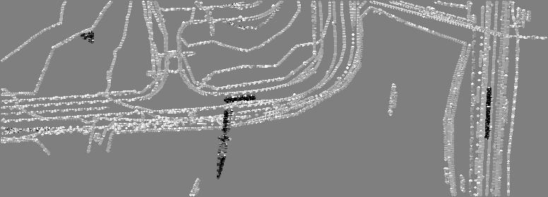
9 SITE Project Mngr. ASZ Scale: PTK Checked B y: ASZ Approved By: PAM Project No A Scale: N.T.S. File Name: Fig 1 Date: September CLEMSON ROAD COLUMBIA, SC PH. (803) FAX. (803) SITE LOCATION MAP EAST GATE ENTRANCE CONTROL FACILITY AMENDMENT SHAW AIR FORCE BASE Sumter, South Carolina FIG No. 1


10
11 CLIENT SITE TRANSYSTEMS SHAW AIR FORCE BASE SUMTER, SOUTH CAROLINA LOG OF BORING NO. CBR-7 PROJECT EAST GATE ECF AMENDMENT SAMPLES TESTS Page 1 of 1 GRAPHIC LOG DESCRIPTION Approx. Surface Elev.: 206 ft 0.3 TOPSOIL, (3 inches) FINE SAND, trace silt, brown to light brown, loose (Coastal Plain) DEPTH, ft. USCS SYMBOL NUMBER TYPE HS RECOVERY, in. SPT - N BLOWS / ft. WATER CONTENT, % SP 1 SS 9 4 DRY UNIT WT pcf UNCONFINED STRENGTH, psf 2% Fines HS 2 SS 5 5 HS 3 SS 8 8 SILTY FINE SAND, light brown, medium dense HS SS BORING TERMINATED BORING TERMINATED BOREHOLE_ A.GPJ GAGE TERRACON.GDT 9/13/10 The stratification lines represent the approximate boundary lines between soil and rock types: in-situ, the transition may be gradual. WATER LEVEL OBSERVATIONS, ft WL WL WL DRY BORING STARTED BORING COMPLETED RIG CME-55 FOREMAN HW APPROVED FRM JOB # A
12 CLIENT SITE TRANSYSTEMS SHAW AIR FORCE BASE SUMTER, SOUTH CAROLINA LOG OF BORING NO. CBR-8 PROJECT EAST GATE ECF AMENDMENT SAMPLES TESTS Page 1 of 1 GRAPHIC LOG DESCRIPTION Approx. Surface Elev.: 208 ft 0.1 TOPSOIL, (1 inch) SILTY FINE SAND, brown, loose (Coastal Plain) 208 DEPTH, ft. USCS SYMBOL NUMBER 1 TYPE HS SS RECOVERY, in. SPT - N BLOWS / ft. 9 WATER CONTENT, % DRY UNIT WT pcf UNCONFINED STRENGTH, psf 3 FINE SAND, trace silt, light brown, loose 205 HS SP 2 SS % Fines 5 HS 3 SS 4 8 CLAYEY FINE SAND, light tannish gray, loose HS SS 7 10 BORING TERMINATED BORING TERMINATED BOREHOLE_ A.GPJ GAGE TERRACON.GDT 9/13/10 The stratification lines represent the approximate boundary lines between soil and rock types: in-situ, the transition may be gradual. WATER LEVEL OBSERVATIONS, ft WL WL WL DRY BORING STARTED BORING COMPLETED RIG CME-55 FOREMAN HW APPROVED FRM JOB # A
13 CLIENT SITE TRANSYSTEMS SHAW AIR FORCE BASE SUMTER, SOUTH CAROLINA LOG OF BORING NO. CBR-9 PROJECT EAST GATE ECF AMENDMENT SAMPLES TESTS Page 1 of 1 GRAPHIC LOG DESCRIPTION Approx. Surface Elev.: 209 ft 0.3 ASPHALT, (3 inches) 0.8 STONE BASE, (6 inches) SILTY FINE SAND, brown, medium dense (Coastal Plain) DEPTH, ft. USCS SYMBOL NUMBER 1 TYPE HS SS RECOVERY, in. SPT - N BLOWS / ft. 12 WATER CONTENT, % DRY UNIT WT pcf UNCONFINED STRENGTH, psf 3 FINE SAND, trace silt, light brown, loose HS SS FINE SAND, with clay, tan to light tannish gray, loose to medium dense SP SM 3 HS SS % Fines HS 4 SS BORING TERMINATED BORING TERMINATED BOREHOLE_ A.GPJ GAGE TERRACON.GDT 9/13/10 The stratification lines represent the approximate boundary lines between soil and rock types: in-situ, the transition may be gradual. WATER LEVEL OBSERVATIONS, ft WL WL WL DRY BORING STARTED BORING COMPLETED RIG CME-55 FOREMAN HW APPROVED FRM JOB # A
14 DCP Data Sheet 1 Project Name: Location Date: Test No. Shaw Air Force Base - East Gate Entrance Control Facility Amendment Sumter, South Carolina 8/13/2010 CBR-9 Blows Scale Reading (mm) Cumulative Penetration (mm) Cumulative Penetration (feet) Penetration Between Readings (mm) Penetration Per Blow (mm) Hammer Factor DCP Index (mm/blow) CBR % Set Notes: 1 The instrument used for this test is typically used to assess the material properties down to a depth of 1000 mm (39 in.) below the surface. Below this depth, the mass and the inertia of the device will change and skin friction along drive rod extensions will occur. As such, the actual CBR values below a depth of 39 in. may be slightly different than reported in this table.
15 Geotechnical Engineering Report East Gate Entrance Control Facility Amendment Sumter, South Carolina September 13, 2010 Terracon Project No A Field Exploration Description Three soil test borings were drilled at the site on August 13, The borings were drilled to a depth of 10 feet below the ground surface at the approximate locations shown on the attached Boring Location Plan. Our personnel located the borings by pacing distances and approximating right angles from the existing site features shown on the provided site plans. The ground surface elevations at the boring locations were interpolated from the contour lines shown on the provided site plans and are shown on the Boring Logs. The boring locations shown on the Boring Location Plans and the ground elevations shown on the Boring Logs are approximate and should be considered accurate only to the degree implied by the method of location. The boreholes were advanced with an ATV-mounted CME-550 drill rig using hollow stem augers. In each boring, standard penetration tests were performed with a manual gravity hammer. The borings were sampled using split-spoons at depth intervals of 2-½ feet. At the completion of the drilling activities, the boreholes were checked for the presence of groundwater at the time of drilling and then were backfilled with auger cuttings at the completion of field exploration. The borings drilled in paved areas were grouted with a cement slurry mix and their surfaces patched with a cold patch asphalt mix after drilling. Representative portions of the split-spoon samples recovered in the borings were placed in glass jars and returned to our laboratory where our engineer visually reviewed and classified them. The purposes of this review were to check the drillers field classifications and visually estimate the soils relative constituents (sand, clay, etc.). The soil types and standard penetration data are shown on the Boring Logs. These records represent our interpretation of the field conditions based on the driller s field logs and our engineer s review of the split-spoon samples. The lines designating the interfaces between various strata represent approximate boundaries only, as transitions between materials may be gradual. Our exploration services include storing the collected soil samples and making them available for inspection for 60 days from the report date. The samples will then be discarded unless requested otherwise. Dynamic cone penetration testing (ASTM D6951) was performed at the boring drilled in pavement (Boring CBR-9). The test was performed by driving the DCP tip into soil by lifting a 10.1-pound sliding hammer to the handle then releasing it. The penetration values represent the number of blows required to advance the penetrometer in 2-inch increments and are an indication of the consistency or density of the soil. The collected data was then used to estimate the in-situ CBR of the subsurface soils. The test was conducted to a depth of about 3 feet below the pavement. The test results are shown in the DCP data sheets included in this appendix.
16 APPENDIX B LABORATORY TEST DATA
17 Geotechnical Engineering Report East Gate Entrance Control Facility Amendment Sumter, South Carolina September 13, 2010 Terracon Project No A Laboratory Testing Description Samples retrieved during the field exploration were taken to the laboratory for further observation by the project geotechnical engineer and were classified in accordance with the Unified Soil Classification System (USCS) described in Appendix C. At that time, the field descriptions were confirmed or modified as necessary and an applicable laboratory testing program was formulated to determine engineering properties of the subsurface materials. Laboratory tests were conducted on selected soil samples and the test results are presented in this appendix. Laboratory tests were performed in general accordance with the applicable ASTM, local or other accepted standards. Selected soil samples obtained from the site were tested for the following engineering properties: In-situ Water Content Standard Proctor CBR Sieve Analysis Fines Content
18 CALIFORNIA BEARING RATIO ( CBR ) TEST REPORT ( ASTM D1883 ) JOB NAME : Shaw AFB - East Gate ECF Amendment DATE : 8/20/10 JOB NO. : A SAMPLE NO. : - BORING / PIT NO. : CBR-7 LIQUID LIMIT, % : n/a DEPTH / ELEV.: 0-5 ft PLASTICITY INDEX, % : n/a SOIL DESCRIPITION : Light brown tan fine SAND FINES, % : n/a PISTON STRESS, PSI Corrected Test Results: At 0.1 inches CBR = 11.0 At 0.2 inches CBR = 16.2 Swell 0.0% Sample Compaction: 100% Standard Proctor at 10.3 percent moisture content Standard Proctor Results: Dry Density of pcf at 10.3 percent moisture content PISTON PENETRATION, INCHES 521 Clemson Road Performed by: FPM Columbia, SC Reviewed by: ASZ
19 CALIFORNIA BEARING RATIO ( CBR ) TEST REPORT ( ASTM D1883 ) JOB NAME : Shaw AFB - East Gate ECF Amendment DATE : 8/24/10 JOB NO. : A SAMPLE NO. : - BORING / PIT NO. : CBR-8 LIQUID LIMIT, % : n/a DEPTH / ELEV.: 0-5 ft PLASTICITY INDEX, % : n/a SOIL DESCRIPITION : Light tan brown fine to medium SAND FINES, % : n/a PISTON STRESS, PSI Corrected Test Results: At 0.1 inches CBR = 18.8 At 0.2 inches CBR = 25.1 Swell 0.0% Sample Compaction: 100% Standard Proctor at 9.5 percent moisture content Standard Proctor Results: Dry Density of pcf at 9.5 percent moisture content PISTON PENETRATION, INCHES 521 Clemson Road Performed by: FPM Columbia, SC Reviewed by: ASZ
20 Source of Material Description of Material Test Method CBR-7 0.0ft Light brownish tan FINE SAND ASTMD698 Method A 115 DRY UNIT WEIGHT, pcf TEST RESULTS Maximum (optimum) Dry Unit Weight Optimum Water Content ATTERBERG LIMITS LL PL PI Curves of 100% Saturation for Specific Gravity Equal to: PCF % 85 TC_COMPACTION A.GPJ GAGE TERRACON.GDT 9/13/ WATER CONTENT, % MOISTURE-DENSITY RELATIONSHIP Project: EAST GATE ECF AMENDMENT Site: SHAW AIR FORCE BASE SUMTER, SOUTH CAROLINA Job #: A Date:
21 Source of Material Description of Material Test Method CBR-8 0.0ft Light tannish brown FINE SAND ASTMD698 Method A 115 DRY UNIT WEIGHT, pcf TEST RESULTS Maximum (optimum) Dry Unit Weight Optimum Water Content ATTERBERG LIMITS LL PL PI Curves of 100% Saturation for Specific Gravity Equal to: PCF % 85 TC_COMPACTION A.GPJ GAGE TERRACON.GDT 9/13/ WATER CONTENT, % MOISTURE-DENSITY RELATIONSHIP Project: EAST GATE ECF AMENDMENT Site: SHAW AIR FORCE BASE SUMTER, SOUTH CAROLINA Job #: A Date:
22 100 U.S. SIEVE OPENING IN INCHES / /4 3/ U.S. SIEVE NUMBERS HYDROMETER PERCENT FINER BY WEIGHT GRAIN SIZE IN MILLIMETERS COBBLES GRAVEL coarse fine coarse medium SAND fine SILT OR CLAY Specimen Identification CBR-7 1.0ft Classification LL PL PI Cc 0.97 Cu 3.60 TC_GRAIN_SIZE A.GPJ GAGE TERRACON.GDT 9/13/10 Specimen Identification CBR-7 1.0ft D100 D60 D30 D10 %Gravel %Sand %Silt GRAIN SIZE DISTRIBUTION Project: EAST GATE ECF AMENDMENT Site: SHAW AIR FORCE BASE SUMTER, SOUTH CAROLINA Job #: A Date: %Clay
23 100 U.S. SIEVE OPENING IN INCHES / /4 3/ U.S. SIEVE NUMBERS HYDROMETER PERCENT FINER BY WEIGHT GRAIN SIZE IN MILLIMETERS COBBLES GRAVEL coarse fine coarse medium SAND fine SILT OR CLAY Specimen Identification CBR-8 3.5ft Classification LL PL PI Cc 0.94 Cu 3.21 TC_GRAIN_SIZE A.GPJ GAGE TERRACON.GDT 9/13/10 Specimen Identification CBR-8 3.5ft D100 D60 D30 D10 %Gravel %Sand %Silt GRAIN SIZE DISTRIBUTION Project: EAST GATE ECF AMENDMENT Site: SHAW AIR FORCE BASE SUMTER, SOUTH CAROLINA Job #: A Date: %Clay
24 100 U.S. SIEVE OPENING IN INCHES / /4 3/ U.S. SIEVE NUMBERS HYDROMETER PERCENT FINER BY WEIGHT GRAIN SIZE IN MILLIMETERS COBBLES GRAVEL coarse fine coarse medium SAND fine SILT OR CLAY Specimen Identification CBR-9 6.0ft Classification LL PL PI Cc Cu TC_GRAIN_SIZE A.GPJ GAGE TERRACON.GDT 9/13/10 Specimen Identification CBR-9 6.0ft D100 D60 D30 D10 %Gravel %Sand %Silt GRAIN SIZE DISTRIBUTION Project: EAST GATE ECF AMENDMENT Site: SHAW AIR FORCE BASE SUMTER, SOUTH CAROLINA Job #: A Date: %Clay
25 Borehole Depth ft Liquid Limit Plastic Limit Plasticity Index Maximum Size (mm) %<#200 Sieve Water Content (%) CBR SP 4 CBR SP 3 CBR Dry Unit Weight (pcf) USCS Classification Saturation (%) Sheet 1 of 1 Void Ratio TC_LAB_SUMMARY A.GPJ GAGE TERRACON.GDT 9/13/10 SUMMARY OF LABORATORY RESULTS Project: EAST GATE ECF AMENDMENT Site: SHAW AIR FORCE BASE SUMTER, SOUTH CAROLINA Job #: A Date:
26 APPENDIX C SUPPORTING DOCUMENTS
27 GENERAL NOTES DRILLING & SAMPLING SYMBOLS: SS: Split Spoon /8" I.D., 2" O.D., unless otherwise noted HS: Hollow Stem Auger ST: Thin-Walled Tube - 2" O.D., unless otherwise noted PA: Power Auger RS: Ring Sampler " I.D., 3" O.D., unless otherwise noted HA: Hand Auger DB: Diamond Bit Coring - 4", N, B RB: Rock Bit BS: Bulk Sample or Auger Sample WB: Wash Boring or Mud Rotary The number of blows required to advance a standard 2-inch O.D. split-spoon sampler (SS) the last 12 inches of the total 18-inch penetration with a 140-pound hammer falling 30 inches is considered the Standard Penetration or N-value. WATER LEVEL MEASUREMENT SYMBOLS: WL: Water Level WS: While Sampling N/E: Not Encountered WCI: Wet Cave in WD: While Drilling DCI: Dry Cave in BCR: Before Casing Removal AB: After Boring ACR: After Casing Removal Water levels indicated on the boring logs are the levels measured in the borings at the times indicated. Groundwater levels at other times and other locations across the site could vary. In pervious soils, the indicated levels may reflect the location of groundwater. In low permeability soils, the accurate determination of groundwater levels may not be possible with only short-term observations. DESCRIPTIVE SOIL CLASSIFICATION: Soil classification is based on the Unified Classification System. Coarse Grained Soils have more than 50% of their dry weight retained on a #200 sieve; their principal descriptors are: boulders, cobbles, gravel or sand. Fine Grained Soils have less than 50% of their dry weight retained on a #200 sieve; they are principally described as clays if they are plastic, and silts if they are slightly plastic or non-plastic. Major constituents may be added as modifiers and minor constituents may be added according to the relative proportions based on grain size. In addition to gradation, coarse-grained soils are defined on the basis of their in-place relative density and fine-grained soils on the basis of their consistency. CONSISTENCY OF FINE-GRAINED SOILS Unconfined Compressive Strength, Qu, psf Standard Penetration or N-value (SS) Blows/Ft. RELATIVE DENSITY OF COARSE-GRAINED SOILS Standard Penetration or N-value (SS) Blows/Ft. Consistency Relative Density < 500 <2 Very Soft 0 3 Very Loose 500 1, Soft 4 9 Loose 1,001 2,000 2, Medium Stiff Medium Dense 2,001 4,000 4, Stiff Dense 4,001 8, Very Stiff 50+ Very Dense 8, Hard RELATIVE PROPORTIONS OF SAND AND GRAVEL Descriptive Term(s) of other constituents Percent of Dry Weight Major Component of Sample GRAIN SIZE TERMINOLOGY Particle Size Trace < 15 Boulders Over 12 in. (300mm) With Cobbles 12 in. to 3 in. (300mm to 75 mm) Modifier > 30 Gravel 3 in. to #4 sieve (75mm to 4.75 mm) RELATIVE PROPORTIONS OF FINES Sand Silt or Clay #4 to #200 sieve (4.75mm to 0.075mm) Passing #200 Sieve (0.075mm) Descriptive Term(s) of other constituents Trace With Modifiers Percent of Dry Weight < > 12 PLASTICITY DESCRIPTION Term Non-plastic Low Medium High Plasticity Index
28 Criteria for Assigning Group Symbols and Group Names Using Laboratory Tests A Coarse Grained Soils More than 50% retained on No. 200 sieve Fine-Grained Soils Silts and Clays 50% or more passes the Liquid limit less than 50 No. 200 sieve UNIFIED SOIL CLASSIFICATION SYSTEM Soil Classification Group Symbol Group Name B Gravels Clean Gravels Cu 4 and 1 Cc 3 E GW Well-graded gravel F More than 50% of coarse Less than 5% fines C fraction retained on Cu 4 and/or 1 Cc 3 E GP Poorly graded gravel F No. 4 sieve Gravels with Fines More Fines classify as ML or MH GM Silty gravel F,G, H than 12% fines C Fines classify as CL or CH GC Clayey gravel F,G,H Sands Clean Sands Cu 6 and 1 Cc 3 E SW Well-graded sand I 50% or more of coarse Less than 5% fines D fraction passes Cu 6 and/or 1 Cc 3 E SP Poorly graded sand I No. 4 sieve Sands with Fines Fines classify as ML or MH SM Silty sand G,H,I More than 12% fines D Fines Classify as CL or CH SC Clayey sand G,H,I Silts and Clays Liquid limit 50 or more Inorganic PI 7 and plots on or above A line J CL Lean clay K,L,M PI 4 or plots below A line J ML Silt K,L,M Organic Liquid limit - oven dried 0.75 OL Organic clay K,L,M,N Liquid limit - not dried Organic silt K,L,M,O Inorganic PI plots on or above A line CH Fat clay K,L,M PI lots below A line MH Elastic Silt K,L,M Organic Liquid limit - oven dried 0.75 OH Organic clay K,L,M,P Liquid limit - not dried Highly organic soils Primarily organic matter, dark in color, and organic odor PT Peat Organic silt K,L,M,Q A Based on the material passing the 3-in. (75-mm) sieve B If field sample contained cobbles or boulders, or both, add with cobbles or boulders, or both to group name. C Gravels with 5 to 12% fines require dual symbols: GW-GM well-graded gravel with silt, GW-GC well-graded gravel with clay, GP-GM poorly graded gravel with silt, GP-GC poorly graded gravel with clay. D Sands with 5 to 12% fines require dual symbols: SW-SM well-graded sand with silt, SW-SC well-graded sand with clay, SP-SM poorly graded sand with silt, SP-SC poorly graded sand with clay E (D30) Cu = D 60/D 10 Cc = D10 x D 2 60 F If soil contains 15% sand, add with sand to group name. G If fines classify as CL-ML, use dual symbol GC-GM, or SC-SM. H If fines are organic, add with organic fines to group name. I If soil contains 15% gravel, add with gravel to group name. J If Atterberg limits plot in shaded area, soil is a CL-ML, silty clay. K If soil contains 15 to 29% plus No. 200, add with sand or with gravel, whichever is predominant. L If soil contains 30% plus No. 200 predominantly sand, add sandy to group name. M If soil contains 30% plus No. 200, predominantly gravel, add gravelly to group name. N PI 4 and plots on or above A line. O PI 4 or plots below A line. P PI plots on or above A line. Q PI plots below A line. Form 111 6/98
Geotechnical Engineering Report
 Geotechnical Engineering Report Shaw AFB West Gate Entrance Control Facility Amendment Sumter, South Carolina September 13, 20 Terracon Project No. 735021A Prepared for: TranSystems North Charleston, South
Geotechnical Engineering Report
 Geotechnical Engineering Report Pavement Subgrade Survey State Highway 125 over Hudson Creek Ottawa County, Oklahoma September 23, 21 Terracon Project No. 415121 Prepared for: Guy Engineering Services,
Typical Subsurface Profile. November 28, 2016
 November 28, 2016 RSCCD Facility Planning, District Construction and Support Services 2323 N. Broadway, Suite 112, Santa Ana, CA 92706 Attn: Re: Ms. Allison Coburn Facilities Project Manager P: (714) 480-7530
Geotechnical Engineering Report
 Geotechnical Engineering Report Turner Turnpike Widening Milepost 203 to 210 Drainage Structure Pipe Jacking Creek County, Oklahoma June 1, 2016 Terracon Project No. 04155197 Prepared for: Garver, LLC
Geotechnical Engineering Report
 Geotechnical Engineering Report Turner Turnpike Widening Milepost 210 to 218 Drainage Structure Pipe Jacking Creek County, Oklahoma July 1, 2016 Terracon Project No. 04165017 Prepared for: Benham Tulsa,
EXHIBIT G GEOTECHNICAL REPORT (DRAFT)
") EXHIBIT G GEOTECHNICAL REPORT (DRAFT) APPENDIX 1 PROJECT SITE 'B' B-1 B-2 I-2 B-3 B-4 B-5 I-1 PROJECT LOCATION LEGEND B-1 = APPROXIMATE BORING LOCATION I-1 = APPROXIMATE INFILTRATION
EXHIBIT G GEOTECHNICAL REPORT (DRAFT) APPENDIX 1 PROJECT SITE 'B' B-1 B-2 I-2 B-3 B-4 B-5 I-1 PROJECT LOCATION LEGEND B-1 = APPROXIMATE BORING LOCATION I-1 = APPROXIMATE INFILTRATION
April 7, Webster Street Sub-Surface Stormwater Storage System Bid No Bid Date: 4/13/17 ADDENDUM NO 1
 PUBLIC WORKS DEPARTMENT David A. Jones, P.E., Director April 7, 2017 Webster Street Sub-Surface Stormwater Storage System Bid No. 2017-022 Bid Date: 4/13/17 ADDENDUM NO 1 Please make the following changes
 Appendix A - Vicinity Map Vicinity Map: Palm Beach Gardens City Hall Additions, 000 N Military Trail, Palm Beach Gardens, FL Proposed Location of Police Dept. Attached Addition Proposed Location of New
November 13, Eckas Water 1514 Ambrosia Court Fort Collins, Colorado Attn: Mr. Wayne Eckas
 November 13, 2018 Eckas Water 1514 Ambrosia Court Fort Collins, Colorado 80526 Attn: Mr. Wayne Eckas (wayne@eckaswater.com) Re: Geotechnical Subsurface Exploration Walker Recharge Pipeline Project Morgan
 FIGURES Printed By: aday Print Date: 3/23/2011 12:48:08 PM File Name: \\geodesign.local\files\jobs\m-r\penskeauto\penskeauto-1\penskeauto-1-01\figures\cad\penskeauto-1-01-vm01.dwg Layout: FIGURE 1 VICINITY
Geotechnical Engineering Report Proposed Communications Tower Spain Park Site Hoover, Alabama
 Geotechnical Engineering Report Proposed Communications Tower Spain Park Site Hoover, Alabama July 24, 2014 Terracon Project No. E1145095 Prepared for: The City Of Hoover Hoover, Alabama Prepared by: Terracon
Geotechnical Engineering Report
 Geotechnical Engineering Report O Reilly Auto Parts Store 1311 E. Nine Mile Road Highland Springs, Virginia August 8, 2012 Project No. 70125105 Prepared for: Oglesby Partners, Inc. Chattanooga, Tennessee
CONTRACT 5E-2 APPENDIX A - TEST HOLE LOGS DYREGROV ROBINSON INC. PORTAGE AVE WINSTON DR BOURKEVALE CAVELL PARKSIDE DR ASSINIBOINE AVE
 APPENDIX A - TEST HOLE LOGS PORTAGE AVE TH -9 CONTRACT E- DR DR BOURKEVALE CAVELL WINSTON DR PARKSIDE DR ASSINIBOINE AVE AUTHORIZED BY: DATE: CONSULTING GEOTECHNICAL ENGINEERS AUTHORIZED /0/ CLIENT DRAWING
ADDENDUM No. 2 BID NO THOMPSON CREEK SUBSTATION DRIVEWAY IMPROVEMENTS PROJECT
 205 E. 28 th St. P.O. Box 1000 Bryan, TX 77805 Phone: 979-821-5860 FAX: 979-821-5747 http://www.btutilities.com November 2, 2015 ADDENDUM No. 2 BID NO. 007-01-16 THOMPSON CREEK SUBSTATION DRIVEWAY
Geotechnical Engineering Report
 Geotechnical Engineering Report Parking Lot Evaluation & Physical Plant Additions Rogers State University Claremore, Oklahoma May 20, 2015 Terracon Project No. 04155080 Prepared for: Rogers State University
Geotechnical Engineering Report
 Geotechnical Engineering Report Rodgers Chapel Expansion 502 James B. Hunt Drive Mount Olive, North Carolina August 26, 2016 Project No. 72165063 Prepared for: University of Mount Olive Mount Olive, North
APPENDIX A DRAINAGE STUDY PHASE 2 ALTERNATIVE IMPROVEMENTS CRYSTAL LAKE ALTERNATIVE 4C IMPROVEMENTS LAKEWOOD PIRATELAND SWASH HORRY COUNTY, SC
 DRAINAGE STUDY PHASE ALTERNATIVE IMPROVEMENTS CRYSTAL LAKE ALTERNATIVE C IMPROVEMENTS ` FOR: LAKEWOOD PIRATELAND SWASH HORRY COUNTY, SC APPENDIX A J-.000 Prepared by: Savannah, GA Charleston, SC Myrtle
GEOTECHNICAL INVESTIGATION I-15 SIGN BRIDGES LAS VEGAS EA JANUARY
 GEOTECHNICAL INVESTIGATION I-15 SIGN BRIDGES LAS VEGAS EA 73171 JANUARY 06 MATERIALS DIVISION STATE OF NEVADA DEPARTMENT OF TRANSPORTATION MATERIALS DIVISION GEOTECHNICAL SECTION GEOTECHNICAL REPORT I-15
GEOTECHNICAL ENGINEERING REPORT
 GEOTECHNICAL ENGINEERING REPORT Project: NW Bucklin Hill at Silverdale Way NW Project Number: 12023 Prepared for: Barber Development P.O. Box 473 Redmond, WA 98073 Prepared by: South Sound Geotechnical
Geotechnical Engineering Report
 Geotechnical Engineering Report Skiatook City Substation Skiatook, Oklahoma October 05, 2017 Terracon Project No. 04175204 Prepared for: GRDA Tulsa, Oklahoma Prepared by: Terracon Consultants, Inc. Tulsa,
Site Location. Figure 1: Site Location Map US-24 and I-275 Interchange Ash Township, Monroe County, Michigan
 Site Location 0606 1771 North Dixie Highway Monroe, Michigan 48162 Tel: 734-289-2200 Fax: 734-289-2345 www.manniksmithgroup.com Figure 1: Site Location Map US-24 and I-275 Interchange Ash Township, Monroe
Geotechnical Engineering Report
 Geotechnical Engineering Report Proposed Retaining Wall 44ARW-1 Interstate 235 between N.W. 50th Street and Interstate 44 Oklahoma City, Oklahoma May 8, 2014 Terracon Project No. 03145071 Prepared for:
Geotechnical Engineering Report
 Proposed Metal Building Recycling Drop-Off Facility 590 Interstate Highway 45 North Huntsville, Texas December 28, 2010 Terracon Project No. 97105093 Prepared for: Jones & Carter, Inc. The Woodlands, Texas
Geotechnical Engineering Report
 Geotechnical Engineering Report Union County Landfill Retaining Wall Wingate, North Carolina October 22, 2015 Project No. 71155054 Prepared for: CDM Smith Charlotte, North Carolina Prepared by: Terracon
Soil Survey Summary Report
 Soil Survey Summary Report Benton Boulevard Extension Pooler, Chatham County, Georgia February, 206 Terracon Project No. ES5553 Prepared for: McGee Partners, Inc. Atlanta, Georgia Prepared by: Terracon
This report presents the findings of the subsurface exploration concerning the design of the taxiway rehabilitation. Description
 September 22, 2016 American Infrastructure Development, Inc. 3810 Northdale Boulevard, Suite 170 Tampa, Florida 33624 Attn: Mr. Mohsen Mohammadi, Ph.D., P.E. Senior Consultant Mob: (813) 244-6609 E-mail:
Geotechnical Engineering Report
 Geotechnical Engineering Report Mt. Pisgah Road Slide Paradise, Utah January 15, 2013 Terracon Project No. 61115029 Prepared for: J-U-B Engineers, Inc. 1047 S 100 W, Suite 180 Logan, UT 84321 Prepared
REPORT OF GEOTECHNICAL EXPLORATION PEPSI PLACE WATER MAIN REPLACEMENT JACKSONVILLE, FLORIDA E&A PROJECT NO CLIENT ID: 4784
 REPORT OF GEOTECHNICAL EXPLORATION PEPSI PLACE WATER MAIN REPLACEMENT JACKSONVILLE, FLORIDA E&A PROJECT NO. 35-55 CLIENT ID: 78 Prepared for: Construction & Engineering Services Consultants, Inc. 93 Baymeadows
Geotechnical Engineering Report
 Geotechnical Engineering Report Richardson Subdivision Apartments 37th Street and Grand Avenue Artesia, New Mexico September 13, 2011 Terracon Project No. 68110 Prepared for: Development Design & Engineering,
GEOTECHNICAL ENGINEERING REPORT. KU Parking Lot 300E Southeast of Lied Center Lawrence, Kansas. Project No. D16G1696. KU No. Lz_n/11062.
 GEOTECHNICAL ENGINEERING REPORT KU Parking Lot 300E Southeast of Lied Center Lawrence, Kansas April 1, 2016 Prepared for: University of Kansas Bartlett & West Prepared by: GeoSource, LLC April 1, 2016
Subsurface Environmental Investigation
 Subsurface Environmental Investigation Lake Development East Lake and 21 st Avenue South February 23, 201 Terracon Project No. MP14738A Prepared for: Minneapolis Public Schools Prepared by: Terracon Consultants,
Florida s Leading Engineering Source
 Since 1988 Florida s Leading Engineering Source Environmental Geotechnical Construction Materials Testing Threshold and Special Inspections Plan Review & Code Compliance Mr. Ron Ridenour Hanson Professional
Sepetember 27, Florida Department of Environmental Protection Attn: Dawn Templin 160 Governmental Center Pensacola, FL
 Bay County Solid Waste 11411 Landfill Rd. Panama City Beach, Florida 32413 Telephone: (850) 236-2212 Fax: (850) 233-5053 Board of County Commissioners www.baycountyfl.gov Sepetember 27, 2018 Florida Department
You also requested information regarding a sieve analysis at each boring locations. The test results are attached.
 FORENSICS CONSULTANTS ENVIRONMENTAL GEOTECHNICAL MATERIALS October 4, 2016 Washington County Public Works 11660 Myeron Road Stillwater, MN 55082 Attn: Mr. Marc Briese Re: Additional Borings CSAH 22 (70
GEOTECHNICAL SUBSURFACE DATA REPORT
 GEOTECHNICAL SUBSURFACE DATA REPORT SC-41 REPLACEMENT BRIDGE OVER MAIDEN DOWN SWAMP MARION COUNTY, SOUTH CAROLINA PREPARED FOR Mr. Joshua Meetze, E.I.T. RPG-2 GDS South Carolina Department of Transportation
Report of Geotechnical Study
 Report of Geotechnical Study Leakes Mill Park Phase 2 Goochland County, Virginia F&R Project No. 60S-0585 Prepared For: Dewberry 4085 Lake Brook Drive, Suite 200 Richmond, Virginia 23060 Prepared By: Froehling
Geotechnical Engineering Report
 Geotechnical Engineering Report County Bridge SH-15 Stillwell Road over Tributary to Stanger Creek Leavenworth County, KS January 13, 2014 Terracon Project No. 02135230 Prepared for: Leavenworth County
GEOTECHNICAL ENGINEERING REPORT
 GEOTECHNICAL ENGINEERING REPORT PROJECT MINECRAFT ACCESS ROAD BOYDTON PLANK ROAD DINWIDDIE COUNTY, VIRGINIA JOB NUMBER: 37775.003 PREPARED FOR: DINWIDDIE COUNTY PO BOX 70 DINWIDDIE COUNTY, STATE 23841
AECOM tel 558 North Main Street fax Oshkosh, Wisconsin 54901
 920.2.0270 tel 8 North Main Street 920.2.021 fax Oshkosh, Wisconsin 4901 May 8, 2012 Mr. James Rabe P.E., CPESC Civil Engineer II City of Oshkosh 21 Church Avenue Oshkosh, WI 490 Subject: Subsurface Exploration
REPORT OF GEOTECHNICAL EXPLORATION AND ENGINEERING ANALYSIS
 FIGURE 3 Geotechnical Report (2) REPORT OF GEOTECHNICAL EXPLORATION AND ENGINEERING ANALYSIS RIVER TOWER RESTORATION RIVER TOWER PARK TAMPA, FLORIDA AREHNA PROJECT NO. B-13-002 February 22, 2013 Prepared
Subsurface Investigation Report. Proposed New 1-Story Building 6447 Grand Avenue Gurnee, Illinois
 AGI Project No. -11 Subsurface Investigation Report For the Proposed New 1-Story Building 6447 Grand Avenue Gurnee, Illinois Prepared for Mr. Steve Panko Key Development Partners, LLC North State Street,
SUBSURFACE INVESTIGATION & GEOTECHNICAL RECOMMENDATIONS PROPOSED MONOPOLE CELL TOWER INDIANAPOLIS, INDIANA A&W PROJECT NO: 15IN0464
 SUBSURFACE INVESTIGATION & GEOTECHNICAL RECOMMENDATIONS PROPOSED MONOPOLE CELL TOWER INDIANAPOLIS, INDIANA A&W PROJECT NO: 15IN0464 PREPARED FOR: AAA DEVELOPMENT AND CONSULTING, INC GREENFIELD, INDIANA
Page 4 Blythe Municipal Airport Project County of Riverside, California December 7, 2015 CTE Job No G
 Geotechnical Investigation Page 4 Blythe Municipal Airport Project County of Riverside, California December 7, 2015 CTE Job No. 40-3264G Laboratory CBR Tests Laboratory CBR tests were performed on samples
REPORT OF GEOTECHNICAL EXPLORATION KINLOCK FM REPLACEMENT NEW MANHOLE STRUCTURE JACKSONVILLE, FLORIDA ECS PROJECT NO A CLIENT ID: 0199
 REPORT OF GEOTECHNICAL EXPLORATION KINLOCK FM REPLACEMENT NEW MANHOLE STRUCTURE JACKSONVILLE, FLORIDA ECS PROJECT NO. 3-6187-A CLIENT ID: 0199 Prepared for: JEA 1 West Church Street Jacksonville, Florida
Geotechnical Engineering Report
 Geotechnical Engineering Report 700 West Pavement SR-0 to 00 South West Valley City, Utah October, 009 Terracon Project No. 6090 Prepared for: Horrocks Engineers 6 West Grove Parkway, Suite 00 Pleasant
Civil Geotechnical Surveying
 Civil Geotechnical Surveying Mr. David Burnett Cabarrus County Schools 4425 Old Airport Road Charlotte, North Carolina 28025 May 16, 2017 Reference: Geotechnical Engineering Evaluation Future PLC Site
Geotechnical Data Report
 Geotechnical Data Report Proposed Prairie Lane HDD Cores D7-A and D7-B Wayne County, Ohio February 14, 2015 Terracon Project No. N4149328 Prepared for: Project Consulting Services, Inc. Prepared by: Terracon
WILLMER ENGINEERING INC. Willmer Project No Prepared for. Clark Patterson Lee Suwanee, Georgia. Prepared by
 SOIL SURVEY REPORT (Revised March 6, 2013) New Hospital Connector Road GDOT Project No. CSSTP-0006-00(276), PI No. 0006276 Duluth, Gwinnett County, Georgia WILLMER ENGINEERING INC. Willmer Project No.
May 2, Mr. Tim Kurmaskie, AIA ARCHITECT KURMASKIE ASSOCIATES, INC Washington Street Raleigh, NC
 Mr. Tim Kurmaskie, AIA ARCHITECT KURMASKIE ASSOCIATES, INC. 1030 Washington Street Raleigh, NC 27605-1258 May 2, 2017 Re: Report of Subsurface Investigation Westfield Rehabilitation & Health Care Additions
Applied GeoScience, Inc Hammond Dr., Suite 6 Schaumburg, Illinois
 AGI Project No. 13-276 Subsurface Investigation Report For the Proposed New Retail Center 9601 South Pulaski Road Evergreen Park, Illinois Prepared for Mr. Feras Sweis FHS Design + Build LLC 2010 West
CHANGE ORDER NO. 3 CITY OF BRYAN CEMETERY EXPANSION PROJECT CITY JOB NO. 572-D April 5, 2016
 CLM Energy Services, LLC 7607 Eastmark, Suite 240 College Station, TX 77840 CHANGE ORDER NO. 3 CITY OF BRYAN CEMETERY EXPANSION PROJECT CITY JOB NO. 572-D5-1303 April 5, 2016 We are submitting Change Order
Geotechnical Engineering Report
 Montana Vista Apartments SEC of Valley Vista Drive and 40 th Street Silver City, New Mexico June 21, 2011 Terracon Project No. 68115036 Prepared for: Western Regional Housing Authority Silver City, New
GEOTECHNICAL REPORT US 93 WILDLIFE UNDERCROSSINGS North of Wells, Nevada E.A July 2009
 GEOTECHNICAL REPORT US 93 WILDLIFE UNDERCROSSINGS North of Wells, Nevada E.A. 73523 July 2009 MATERIALS DIVISION STATE OF NEVADA DEPARTMENT OF TRANSPORTATION MATERIALS DIVISION GEOTECHNICAL SECTION GEOTECHNICAL
GEOTECHNICAL REPORT B-1942
 GEOTECHNICAL REPORT TUSCARORA BRIDGE REPLACEMENT B-1942 E.A. 73561 March 2011 MATERIALS DIVISION STATE OF NEVADA DEPARTMENT OF TRANSPORTATION MATERIALS DIVISION GEOTECHNICAL SECTION GEOTECHNICAL REPORT
GEOTECHNICAL REPORT US 95 WIDENING ANN ROAD
 GEOTECHNICAL REPORT US 95 WIDENING ANN ROAD to KYLE CANYON ROAD Package 2 E.A. 73627 January 212 MATERIALS DIVISION STATE OF NEVADA DEPARTMENT OF TRANSPORTATION MATERIALS DIVISION GEOTECHNICAL SECTION
LTISD PURCHASING DEPARTMENT HWY 71, BLDG B AUSTIN, TX 78738
 LTISD PURCHASING DEPARTMENT 16101 HWY 71, BLDG B AUSTIN, TX 78738 March 23, 2018 NOTICE TO VENDORS This notice serves as ADDENDUM #3 for Request for Competitive Sealed Proposal (RFCSP), Number 18-03-012,
April 21, Odom Investments, Inc. Attn: Mr. Jerry Odom 7100 Westwind Dr., Suite 230 El Paso, TX 79912
 April 21, 2016 Odom Investments, Inc. Attn: Mr. Jerry Odom 7100 Westwind Dr., Suite 230 El Paso, TX 79912 Re: GEOTECHNICAL ENGINEERING REPORT Proposed San Elizario Retail Center Socorro Road & Chicken
Geotechnical Engineering Report
 Saluda 1 Pump Station Greenville, South Carolina January 7, 2016 Terracon Project No. 86155060 Prepared for: Renewable Water Resources (ReWa) Greenville, South Carolina Prepared by: Terracon Consultants,
GEOTEK ENGINEERING & TESTING SERVICES, INC. 909 East 50 th Street North Sioux Falls, South Dakota Phone Fax
 GEOTEK ENGINEERING & TESTING SERVICES, INC. 909 East 50 th Street North Sioux Falls, South Dakota 57104 Phone 605-335-5512 Fax 605-335-0773 September 8, 2016 City of Viborg 101 N. Main Street 57070 Attn:
Subsurface Investigation and Geotechnical Analysis Target Outparcel Midlothian Turnpike Richmond, Virginia. Client: Interface Properties
 Subsurface Investigation and Geotechnical Analysis Target Outparcel 11309 Midlothian Turnpike Richmond, Virginia Client: Interface Properties December 5, 2017 December 5, 2017 The Heritage Group, LLC Attn:
Geotechnical Engineering Report
 REPORT C OVER PAGE Geotechnical Engineering Report GDRTA Building 600 Renovations Dayton, Montgomery County, Ohio March 16, 2018 Terracon Project No. N1185054 Prepared for: Champlin Architecture Cincinnati,
Drainage Repairs (A-Side) Western Missouri Correctional Center Cameron, MO Project No: C
 Western Missouri Correctional Center Cameron, MO Project No: C") Addendum No. 1 TO: PLANS AND SPECIFICATIONS FOR: Drainage Repairs (A-Side) Western Missouri Correctional Center Cameron, MO Project No: C1702-01 BIDDERS ARE HEREBY INFORMED THAT THE CONSTRUCTION PLANS
Addendum No. 1 TO: PLANS AND SPECIFICATIONS FOR: Drainage Repairs (A-Side) Western Missouri Correctional Center Cameron, MO Project No: C1702-01 BIDDERS ARE HEREBY INFORMED THAT THE CONSTRUCTION PLANS
GEOTECHNICAL INVESTIGATION PROPOSED OUTFALL LOCATION CITY OF MORGAN S POINT DRAINAGE HARRIS COUNTY, TEXAS REPORT NO
 GEOTECHNICAL INVESTIGATION PROPOSED OUTFALL LOCATION CITY OF MORGAN S POINT DRAINAGE HARRIS COUNTY, TEXAS REPORT NO. 1140198001 Reported to: SIRRUS ENGINEERS, INC. Houston, Texas Submitted by: GEOTEST
June i TABLE OF CONTENTS
 June 2005 - i - 05-526 TABLE OF CONTENTS SECTION PAGE 1.0 INTRODUCTION... 1 1.1 Purpose of the Investigation... 1 1.2 Description of the Project and Scope of Work... 1 1.3 Site Geology... 1 1.4 Site Description
CONDUCTED FOR: PREPARED FOR: 18 October 2010 YPC Project No. 10GY133
 GEOTECHNICAL EXPLORATION AND ENGINEERING SERVICES REPORT CONDUCTED FOR: Immokalee Stormwater Master Plan Implementation Immokalee, Collier County, Florida PREPARED FOR: Mr. Marc Stonehouse, P. E. Project
REPORT OF GEOTECHNICAL EXPLORATION BYFORGE ENGINEERING FOR REFERENCE ONLY
 REPORT OF GEOTECHNICAL EXPLORATION BYFORGE ENGINEERING FOR REFERENCE ONLY HERITAGE BAY MASTER PUMP STATION ISSUED FOR BID REPORT OF GEOTECHNICAL EXPLORATION PROPOSED INLINE WASTEWATER BOOSTER STATION Collier
Introduction to Road Soil
 Introduction to Road Soil Characterization By: Dr. Curtis F. Berthelot P.Eng. Department of Civil and Geological Engineering Centre of Excellence for Transportation ti and Infrastructure t Road Soil Introduction
Geotechnical Engineering Report
 The Residence at Yukon Hills Cornwell Drive and Vandament Avenue Yukon, Oklahoma May 20, 2016 Terracon Project No. 03165108 Prepared for: Jones Gillam Renz Architects, Inc. Salina, Kansas Prepared by:
Draft Geotechnical Engineering Services
 May 20, 2011 Draft Geotechnical Engineering Services Proposed Weir Wall at Stockbridge Stormwater Management Facility Prince William County, Virginia 19955 Highland Vista Drive, Suite 170 Ashburn, VA 20147
Earth Mechanics, Inc. Geotechnical & Earthquake Engineering
 Earth Mechanics, Inc. Geotechnical & Earthquake Engineering TECHNICAL MEMORANDUM DATE: June 3, 2009 EMI PROJECT NO: 01-143 TO: COPY: FROM: SUBJECT: John Chun, P.E. / Port of Long Beach (POLB) Jorge Castillo
Ardaman & Associates, Inc. Geotechnical, Environmental and Materials Consultants
 SUBSURFACE SOIL EXPLORATION ANALYSIS AND RECOMMENDATIONS PROPOSED WEIRS AT STATIONS 130+00 AND 16+00 DRAINAGE IMPROVEMENTS TO THE FOUR CORNERS MSBU HENDRY COUNTY, FLORIDA Ardaman & Associates, Inc. Geotechnical,
Geotechnical Engineering Report
 Geotechnical Engineering Report Proposed Abbington Crossing Apartments 119 Lipscomb Road Wilson, North Carolina March 18, 2016 Project No. 7216011 Prepared for: Rea Ventures Group, LLC Atlanta, Georgia
REPORT OF SUBSURFACE EXPLORATION AND GEOTECHNICAL ENGINEERING ANALYSIS DOLLAR TREE GREENVILLE, NC GREENVILLE, PITT COUNTY, NORTH CAROLINA
 REPORT OF SUBSURFACE EXPLORATION AND GEOTECHNICAL ENGINEERING ANALYSIS DOLLAR TREE GREENVILLE, NC GREENVILLE, PITT COUNTY, NORTH CAROLINA PREPARED FOR: MR. K. SCOTT BOWMAN CLARK, GEER, LATHAM & AOCIATES,
Geotechnical Exploration and Evaluation Report
 Geotechnical Exploration and Evaluation Report Nassau Reclaimed Water Main From Radio Avenue to Harts Road Nassau County, Florida CSI Geo Project No.: 71-17-329-04 Client Project No.: JEA 09302-049-01
For. Report of Geotechnical Exploration. University of North Florida Parking Lot 47 Jacksonville, Florida
 Report of Geotechnical Exploration For University of North Florida Parking Lot 47 Jacksonville, Florida MAE Project No. 0019-0009 April 5, 2017 Revised: April 6, 2017 Prepared for: Prepared by: Jacksonville,
GEOTEK ENGINEERING & TESTING SERVICES, INC. 909 East 50 th Street North Sioux Falls, South Dakota Fax
 GEOTEK EGIEERIG & TESTIG SERVICES, IC. 909 East 0 th Street orth Sioux Falls, South Dakota 0 0-- Fax 0--0 South Dakota State University Facilities and Services Admistration 0, PO Box 0 Brookgs, South Dakota
REPORT OF GEOTECHNICAL EXPLORATION WEST MARJORY AVENUE TAMPA, FLORIDA
 REPORT OF GEOTECHNICAL EXPLORATION WEST MARJORY AVENUE TAMPA, FLORIDA AREHNA PROJECT NO. B-15-008 March 11, 2015 Prepared For: City of Tampa Stormwater Division 306 W. Jackson Street, 6N Tampa, Florida
Geotechnical Investigation for Navajo Gallup Water Supply Project Reach 26.3
 Geotechnical Investigation for Navajo Gallup Water Supply Project Reach 26.3 Geo-Test Geotechnical Engineering Services Report No. 1-718 for Reach 26.3 Tank Site Geo-Test Job No. 1-718, Addendum No. 1
Amendment 03 Soils Report. At Air Academy High School 6910 Carlton Drive Colorado Springs, CO 80840
 Amendment 03 Soils Report Issued: November 7, 2017 For RFP 18-KG-0928(BF) Design/Build Services for New Synthetic Turf Field At Air Academy High School 6910 Carlton Drive Colorado Springs, CO 80840 Academy
PRELIMINARY GEOTECHNICAL SUBSURFACE EXPLORATION REPORT PROPOSED HAUCK FARMS RESIDENTIAL DEVELOPMENT (LOT 1, FOX CHASE 1 ST AMENDED) 7624 COUNTY ROAD
 7624 COUNTY ROAD") PRELIMINARY GEOTECHNICAL SUBSURFACE EXPLORATION REPORT PROPOSED HAUCK FARMS RESIDENTIAL DEVELOPMENT (LOT 1, FOX CHASE 1 ST AMENDED) 7624 COUNTY ROAD 5, FREDERICK, COLORADO SOILOGIC # 171201 August 3, 2017
PRELIMINARY GEOTECHNICAL SUBSURFACE EXPLORATION REPORT PROPOSED HAUCK FARMS RESIDENTIAL DEVELOPMENT (LOT 1, FOX CHASE 1 ST AMENDED) 7624 COUNTY ROAD 5, FREDERICK, COLORADO SOILOGIC # 171201 August 3, 2017
Thi_ Qar University College of Engineering/Civil Engineering Department. Highway Lectures. Fourth Class. Part #2: - Subgrade Soil
 Thi_ Qar University College of Engineering/Civil Engineering Department Highway Lectures Fourth Class Part #2: - Subgrade Soil Lecture #2 Soil Classification DAS, Chapter 4, Engineering Classification
CONDUCTED FOR: PREPARED FOR: 5 May 2016 YPC Project No. 16GY146
 GEOTECHNICAL EXPLORATION SERVICES REPORT CONDUCTED FOR: Collier Boulevard PREPARED FOR: Mr. Christopher L. Johnson Director of Land Development Stock Development, LLC Professional Circle, Suite 01 Naples,
November 14, Robert Peccia & Associates, Inc. PO Box 5653 Helena, MT Mr. Bill Burkland, P.E.
 November 14, 2018 Robert Peccia & Associates, Inc. PO Box 63 9604 Attention: Subject: Gentlemen: Mr. Bill Burkland, P.E. bill@rpa-hln.com Final Report of Geotechnical Investigation Upgrades to Taxiways
Report of Exploratory Test Pits
 Report of Exploratory Test Pits UNF Transportation Projects Stockpile Investigation Osprey Ridge Road Extension Jacksonville, Florida CSI Geo Project No.: 71-17-135-20 Arcadis Project No.: JK017002.0001
PD - 6 THRUST RESTRAINT DESIGN EQUATIONS AND SOIL PARAMETERS FOR DUCTILE IRON AND PVC PIPE
 PD - 6 THRUST RESTRAINT DESIGN EQUATIONS AND SOIL PARAMETERS FOR DUCTILE IRON AND PVC PIPE 4 3 2 1 D D C C B B A A 4 3 2 1 Thrust Restraint Design Equations and Soil Parameters These equations and soil
BID: CTC Dirt Road Paving Durango Lane, Dakota Circle, and Angler Lane BID DUE: Tuesday, December 11, 11:00am
 Capital Projects & Purchasing Department 113 Mable T. Willis Blvd. Walterboro, SC 29488 843.539.1968 BID: CTC-13 2018 Dirt Road Paving Durango Lane, Dakota Circle, and Angler Lane BID DUE: Tuesday, December
REPORT OF GEOTECHNICAL EXPLORATION GLYNN COUNTY DETENTION CENTER GLYNN COUNTY, GEORGIA E&A PROJECT NO
 REPORT OF GEOTECHNICAL EXPLORATION GLYNN COUNTY DETENTION CENTER GLYNN COUNTY, GEORGIA E&A PROJECT NO. - Prepared for: IPG Architects, Inc. Northwood Park Drive Valdosta, Georgia Prepared by: Ellis & Associates,
GEOTECHNICAL EXPLORATION FOR PROPOSED PAVEMENT IMPROVEMENTS, SIERRA MIDDLE SCHOOL, 4950 CENTRAL AVENUE, CITY OF RIVERSIDE, CALIFORNIA.
 GEOTECHNICAL EXPLORATION FOR PROPOSED PAVEMENT IMPROVEMENTS, SIERRA MIDDLE SCHOOL, 4950 CENTRAL AVENUE, CITY OF RIVERSIDE, CALIFORNIA Prepared for: RIVERSIDE UNIFIED SCHOOL DISTRICT 3070 Washington Street
Geotechnical Engineering Report
 BIG CYPRESS SEMINOLE INDIAN RESERVATION WATER TREATMENT FACILITY October 29, 2015 Terracon Project No. HD155065 Prepared for: REISS ENGINEERING, INC. 1016 Spring Villas Pt. Winter Springs, FL 32708 Prepared
TRENCH EXCAVATION AND BACKFILL
 TRENCH EXCAVATION AND BACKFILL PART 1 - GENERAL 1.01 SECTION INCLUDES A. Trench Excavation for Pipe Systems B. Trench Foundation Stabilization C. Pipe Bedding and Backfill 1.02 DESCRIPTION OF WORK A. Excavate
mtec REPORT OF GEOTECHNICAL EXPLORATION FTFA Construct Bin Wall at HERD Eglin AFB, Florida
 mtec REPORT OF GEOTECHNICAL EXPLORATION FTFA 14-3001 - Construct Bin Wall at HERD Eglin AFB, Florida MTEC Project Number 2014-101 November 10, 2014 Revised: January 5, 2015 Prepared For: Peterson Engineering,
GEOTEK ENGINEERING & TESTING SERVICES, INC. 909 East 50 th Street North Sioux Falls, South Dakota Phone Fax
 GEOTEK ENGINEERING & TESTING SERVICES, INC. 909 East 50 th Street North Sioux Falls, South Dakota 57104 Phone 605-335-5512 Fax 605-335-0773 October 28, 2016 City of Vermillion 25 Center Street 57069 Attn:
4. GEOTECHNICAL FIELD INVESTIGATION SUMMARY
 Rev. 0 Date: AUGUST 18, 2012 Project.: COUVA CHILDREN S HOSPITAL - COUVA, TRINIDAD Page 29 Title: EISL-412-DD-TR-2012 PRELIMINARY GEOTECHNICAL FEASIBILITY REPORT 4. GEOTECHNICAL FIELD INVESTIGATION SUMMARY
DEPARTMENT OF TRANSPORTATION DIVISION: MATERIALS REPORT COVER SHEET. Revised Soil Survey Report November 24, 2015 Matthew G. Moore, P.E.
 LD-0 /12/09 DEPARTMENT OF TRANSPORTATION DIVISION: MATERIALS REPORT COVER SHEET Revised Soil Survey Report November 2, 201 Matthew G. Moore, P.E. VDOT (Division) or Company Name Insert Location, Virginia
CEEN Geotechnical Engineering
 CEEN 3160 - Geotechnical Engineering Lab Report 1 Soil Classification prepared by Student Name 1 Student Name 2 Student Name 3 Student Name 4 Tuesday Lab Time 9:30 10:45 Lab Team 1 Submission Date INTRODUCTION
GEOTEK ENGINEERING & TESTING SERVICES, INC. 909 East 50 th Street North Sioux Falls, South Dakota Phone Fax
 GEOTEK ENGINEERING & TESTING SERVICES, INC. 909 East 50 th Street North Sioux Falls, South Dakota 57104 Phone 605-335-5512 Fax 605-335-0773 November 1, 2016 City of Viborg PO Box 56 57070-0056 Attn: Lori
Subsurface Investigation Report
 AGI Project No. 17-154 Subsurface Investigation Report For the Proposed New One-Story Building Addition 7030 West 111 th Street Worth, Illinois Prepared for T63 Development LLC 11052 Mayflow er Lane Orland
SECTION UTILITY BACKFILL MATERIALS
 SECTION 31 23 23 UTILITY BACKFILL MATERIALS PART 1: GENERAL 1.01 SECTION INCLUDES A. Material Classifications B. : 1. Concrete sand 2. Gem sand 3. Pea gravel 4. Crushed stone 5. Crushed concrete 6. Bank
Report of Geotechnical Study
 Report of Geotechnical Study Albemarle County, Virginia F&R Project No. 71T0082 Prepared For: Office of Facilities Development 401 McIntire Road, Room 228 Charlottesville, Virginia 22902-4596 Prepared
REPORT OF SUBSURFACE EXPLORATION AND GEOTECHNICAL ANALYSIS DMA TAMPA RED BRICK BUILDING TAMPA, FLORIDA FOR MRI ARCHITECTURAL GROUP, INC.
 REPORT OF SUBSURFACE EXPLORATION AND GEOTECHNICAL ANALYSIS DMA TAMPA RED BRICK BUILDING TAMPA, FLORIDA FOR MRI ARCHITECTURAL GROUP, INC. JANUARY 7, 2015 January 7, 2015 Mr. Pete Ikegami MRI Architectural