Management, Protection and Sustainable Use of Groundwater and Soil Resources in the Arab Region. WEAP-MODFLOW Tutorial
|
|
|
- Beverly Summers
- 6 years ago
- Views:
Transcription


1 Management, Protection and Sustainable Use of Groundwater and Soil Resources in the Arab Region WEAP-MODFLOW Tutorial September 2012
 With participation of J. Al Mahameed (ACSAD) A.")
 Online available at http://www.bgr.bund.")
2 WEAP-MODFLOW Tutorial Version 2 Authors M. Huber (geo:tools) M. Al-Sibai (ACSAD) With participation of J. Al Mahameed (ACSAD) A. Abdallah (ACSAD) O. Al Shihabi (ACSAD) I. Jnad (ACSAD) J. Wolfer J. Maßmann (BGR) Online available at WEAP-MODFLOW-Tutorial 2/45
3 Content 1 Introduction MODFLOW Model Model Area Main River Basin Mathematical Model Create and link a WEAP-model based on MODFLOW data Create a new WEAP Area Start LinkKitchen Set the WEAP Area s Boundary Add Catchment and Groundwater Nodes to the Schematic Add Rivers to the Schematic Set the Model Runtime in WEAP Define Catchment and Groundwater in the Linkage File Define Rivers in the Linkage File Set the FLOW-STAGE-WIDTH relationship Send Linkage File Data to WEAP Send catchment areas to WEAP Send groundwater recharge to WEAP Link WEAP and MODFLOW WEAP-hydrology in linked models Rainfall-Runoff Add Runoff links to the Schematic Assign catchments and Landuse Classes to the Linkage File Data input in WEAP Enter precipitation Enter ETRef Enter Kc Enter Runoff- and Infiltration fractions Run the model and browse the results Common tasks Abstraction for irrigation Add irrigation abstraction by demand site Add irrigation abstraction to a Landuse Class Changes in Land Use Urbanization Irrigation growth Domestic water supply from well fields Artificial groundwater recharge Climate Change WEAP-MODFLOW-Tutorial 3/45
4 1 Introduction The present tutorial intends to illustrate the idea of the dynamic link between WEAP and MODFLOW. The techniques presented are kept as simple as possible in order to make you familiar with the necessary steps for building up a WEAP model that is linked to MODFLOW and to give you an introduction to solving common water management problems. The first part will guide you through building a WEAP model based on the data stored in a MODFLOW model ( Hard Data approach ). Despite this approach is not recommended in general, as flexibility is lost and many of WEAP s powerful modelling options are not available, it might be useful in case measured data (e.g. precipitation) used to build and calibrate the existing MODFLOW model is unavailable for whatever reason. The second part focusses on building and linking a model that makes use of WEAP s internal functions to model groundwater recharge and surface runoff. In the last part, you will learn how to cope with various challenges typical to modellers like implementing artificial recharge or changes in land use. Before you start with the tutorial, be advised to have downloaded the associated shape files (Catchment.shp, Landuse.shp, Wellfields.shp) and the csv-file (InputData.csv). This tutorial refers to WEAP Version (Sep 2012) and LinkKitchen Version 1.00 (Sep 2012). It is based on the WEAP-MODFLOW-Tutorial by BGR/ACSAD (2009) and includes contributions by M. Al-Sibai (Chapter 2). WEAP-MODFLOW-Tutorial 4/45 Introduction


 to North (335 m.")
5 2 MODFLOW Model The MODFLOW model used in this tutorial was designed with the intention to make many planning options possible (dams, irrigation) and to remain easy to understand. It is a modification of the original GMS-Tutorial model and in the following named Main River Basin. 2.1 Model Area Main River Basin The Main River basin encompasses 783 square kilometres. It is located in a semi-arid climate, with precipitation only in the winter months. Most of this precipitation is lost by evapotranspiration. The aquifer consists of fractured crystalline bedrock and alluvial fills in the valleys, its saturated thickness varies between 35 m in the South to about 53 m in the North. Groundwater flow is towards the spring, the Main River and its 2 tributaries. The spring represents the headflow of the Main river, with an average monthly discharge of about m³. In the north, outside the model area the Main River finally drains into a reservoir lake with a constant water level of m a.s.l. The topography gradually decreases from South (353 m.a.s.l) to North (335 m.a.s.l). Elevation dem Value High : Low : WEAP-MODFLOW-Tutorial 5/45 MODFLOW Model
 with 88x70 cells.")
.")


6 2.2 Mathematical Model GRID: The model consists of one layer (1 unconfined aquifer, 60-80m layer thickness, 35m 50m saturated thickness) with 88x70 cells. The cell sizes vary in width and height between 200 m to 1200 m (see figure below) BOUNDARY CONDITIONS: Specified-Head boundary in the North (Reservoir Lake level). All other boundaries are No-Flow boundaries (see figure above). HYDRAULIC CONDUCTIVITY: The 4 hydraulic conductivity zones for the model are shown in the figure below. The hydraulic conductivity of the aquifer varies between 100 m/day along the river valley to 40 m/day towards the basin boundary. 0 m/d m/d m/d m/d m/d WEAP-MODFLOW-Tutorial 6/45 MODFLOW Model
 and the rivers as RIVER-cells (blue in the figures above).")

 shows that the model is almost balanced or close to steady state, with recharge as the")
7 RECHARGE: 5 different recharge zones have been defined. The values in the zones ranging from 0 to m/d (see figure above). ADDITIONAL PACKAGES: The spring was modelled as 2 DRAIN-cells (pink in the figure above) and the rivers as RIVER-cells (blue in the figures above). INITIAL HEAD: The initial head ranges from m.a.s.l. resulting in a depth to water table of 25 to 36 m (see figures below). Starting Heads: Depth to groundwater table The Model has been built and run on transient state in order to cover two years of recharge variation. It consists of 24 monthly stress periods, which contain 3 equal time steps each. The final balance (see figure below units in m³ or m³/d) shows that the model is almost balanced or close to steady state, with recharge as the main inflow and river leakage as the main outflow fraction. WEAP-MODFLOW-Tutorial 7/45 MODFLOW Model
8 3 Create and link a WEAP-model based on MODFLOW data At the beginning, you will create a new WEAP Area and design the Schematic for it. The necessary tasks are: Create a new WEAP area Set the area s spatial boundaries Load background layers Digitize 4 rivers Add 5 catchment and 5 groundwater nodes The result will look similar to the image below. WEAP-MODFLOW-Tutorial 8/45 Hard-Data-Approach


9 3.1 Create a new WEAP Area 1. In the Main Menu in WEAP, go to Area Create Area. In the following dialog, create a new Area, which is initially blank and give it the name: DSS-Tutorial : 2. Click OK and ignore the following dialog ( Area boundary ) by clicking on Cancel. The model should look like below: WEAP-MODFLOW-Tutorial 9/45 Hard-Data-Approach


10 3.2 Start LinkKitchen LinkKitchen is a GIS-alike tool designed to assist the setup of the Linkage Shapefile without the need of further GIS- and Spreadsheet-software. It provides all necessary functionality for producing the linkage file and for its attribution. Furthermore, it allows direct parameterization of the WEAP-model based on linkage file s attributes. If you are not yet familiar with the use of LinkKitchen, please read its User Manual before you continue with the tutorial. Remain WEAP open and start LinkKitchen in parallel. At start-up, you are prompted to select the one of your WEAP models which you want to work on. Select DSS-Tutorial and confirm the dialog by click on OK. In the following dialog, LinkKitchen prompts for the location of the MODFLOW model and the Linkage File. Browse for the MODFLOW model that comes with the Tutorial data and select the Namefile. As a linkage file does not yet exist, select to create a new Linkage File. Once you confirm with OK, all MODFLOW files will be copied to the WEAP-Area s standard directory. LinkKitchen produces the Linkage File as well as two other shapefiles in the background. Those will be used during the next steps. WEAP-MODFLOW-Tutorial 10/45 Hard-Data-Approach
. Right-click into the Layer-pane and select Add Vector Layer from the context menu.")

11 3.3 Set the WEAP Area s Boundary Your LinkKitchen User Interface will show an empty grid that represents the geometry of your MODFLOW model. This is the linkage File. Switch back to WEAP (don t close LinkKitchen). Right-click into the Layer-pane and select Add Vector Layer from the context menu. Browse to your WEAP Area directory/shape/ and select the file MF_Domain_trans_modify_5f_drain.shp. This file was created at start-up and represents the spatial boundary of the MODFLOW model. You will use this file to define the area s boundaries. Remove all other layers (Major Rivers, States, Country, Ocean) except MF_Domain_trans_modify_5f_drain.shp. WEAP-MODFLOW-Tutorial 11/45 Hard-Data-Approach

 and confirm")
12 Right-click into the Layer-pane and select Set Area Boundaries from the context menu. Draw the green rectangle (the area boundary) around the complete extent of the black rectangle (the MODFLOW model s extent) and confirm by click on OK. WEAP-MODFLOW-Tutorial 12/45 Hard-Data-Approach
13 3.4 Add Catchment and Groundwater Nodes to the Schematic It is assumed, that MODFLOW is the only source of information about the model area. Catchments and Groundwater nodes are thus delineated by zones of equal recharge rate. You will use LinkKitchen to delineate the Catchment and Groundwater zones in WEAP. 1. Switch to LinkKitchen and browse to the MODFLOW-Layer Recharge SP1 in the MODFLOW Viewer. Click the Preview-Button to show the recharge zones. 2. Click the Make Snapshot-button to save the preview-image permanently to disc. The image appears in the List of Layers as a regular Background Layer. 3. At this stage, the recharge zones are saved as a JPEG-image-file in the WEAP-area directory. The file doesn t store any information besides a different colour for each zone. WEAP-MODFLOW-Tutorial 13/45 Hard-Data-Approach


14 4. Switch back to WEAP and load the file Recharge_SP1.jpg as a background raster layer to the Schematic. WEAP-MODFLOW-Tutorial 14/45 Hard-Data-Approach
15 In the MODFLOW model, five zones of different recharge are defined. You will take these zones as blueprints for the delineation of WEAP-Catchments and groundwater nodes. 1. Drag and drop one Catchment and one Groundwater node for each recharge zone onto the schematic. 2. Connect the Groundwater and Catchment nodes by infiltration links. Catchment node name connection groundwater node name C_East infiltration link GW_East C_MainCentral infiltration link GW_MainCentral C_MainLower infiltration link GW_MainLower C_MainUpper infiltration link GW_MainUpper C_West infiltration link GW_West NOTE: It is good practice to add the prefix C_ before the catchment s name and the prefix GW_ before groundwater nodes in order to avoid getting confused by identical names of groundwater nodes, catchments and demand sites. WEAP-MODFLOW-Tutorial 15/45 Hard-Data-Approach
 to the Schematic and give it a solid blue colour. 2.")

16 3.5 Add Rivers to the Schematic 1. Add the file MF_River_trans_modify_5f_drain.shp (located in the folder SHAPE in the area directory) to the Schematic and give it a solid blue colour. 2. Drag and Drop river nodes onto the Schematic and digitize each river, in flow direction, on top of the blue area. The rivers names are Main River, East River and West River. East River and West River are tributaries to Main River. 3. A fourth River needs to be digitized in addition to the three rivers. In MODFLOW, it is represented by two drain cells upstream of Main River. That River is named Spring. WEAP-MODFLOW-Tutorial 16/45 Hard-Data-Approach
.")

17 3.6 Set the Model Runtime in WEAP In order to ensure, the WEAP calculation correlates correctly with the MODFLOW model, adjust the WEAP time steps and the starting month according to the MODFLOW stress periods (here: October 1999 September 2001). This is done using the General menu item Years and Time Steps Initially you won t use any WEAP internal model to calculate surface runoff, groundwater recharge and irrigation demand, therefore choose in Data View Demand Sites and Catchments Advanced WEAP-MODFLOW-Tutorial 17/45 Hard-Data-Approach
18 3.7 Define Catchment and Groundwater in the Linkage File Switch back to LinkKitchen and see how it reflects the changes you made in WEAP. The Nodes you added to the Schematic are now visible in LinkKitchen s Branch Viewer. During the following steps, you will relate cells of the Linkage File to Catchments, Groundwater Nodes and Rivers. As you have the recharge zones loaded in the background, you will use these zones as stencils for selecting cells. Use LinkKitchen s selection-tools (s. LinkKitchen User Manual) to select cells corresponding to recharge-zones. The thus selected cells are then attributed with the name of the catchment as defined in WEAP. The procedure of attributing groundwater nodes is identical. 1. Select all cells located in the green area (C_Main Upper). WEAP-MODFLOW-Tutorial 18/45 Hard-Data-Approach


19 2. Highlight C_MainUpper in the Branch-Viewer and click Add Attribute to Linkage File. This will write the Branch s name to the linkage file. 3. Highlight GW_MainUpper and click Add Attribute to Linkage File. 3. Repeat Steps 1 and 2 for the other Catchments 4. Highlight the Parent-Branch Catchments and look at the Linkage File Preview: WEAP-MODFLOW-Tutorial 19/45 Hard-Data-Approach

20 WEAP-MODFLOW-Tutorial 20/45 Hard-Data-Approach


21 3.8 Define Rivers in the Linkage File In WEAP, a river is defined as a chain of reaches, sections between inflow or outflow nodes. Any river reach requires to have a representation in the Linkage File. There are two different ways to assign river reaches to the Linkage File. The method to choose depends on how accurate you digitized the rivers in the WEAP Schematic beforehand. If the WEAPrivers are digitized very accurately with no overlaps of the river lines out of the blue river cells, you should opt for method 2. If the rivers are digitized only roughly around the river cells, choose the first method. Both methods are described in the following section. Simplistic Method 1 Accurate Method 2 Method 1: The procedure to assign river reaches to Linkage File cells is similar to the procedure to assign Catchments except that you start from Information you get from MODFLOW rather than from an overlay shapefile. 1. In the MODFLOW-Viewer, browse to the Layer IsDrain and click select. The drain cells represent the river Spring in WEAP. WEAP-MODFLOW-Tutorial 21/45 Hard-Data-Approach


22 2. Highlight the River-branch Below Spring Headflow in the Branches-Viewer and click Add Attribute to Linkage File. The two drain cells are now linked to the WEAP river reach Below Spring Headflow. 3. Browse to the layer IsRiver in the MODFLOW Viewer to select River cells. 4. Use LinkKitchen s selection-tools to sub-select those cells corresponding to the WEAP-rivers. E.g. Click and hold the Alt-Key while drawing a rectangle around West River in order to select from selected river cells. WEAP-MODFLOW-Tutorial 22/45 Hard-Data-Approach


23 5. Highlight the River-branch Below West River Headflow in the Branches-Viewer and click Add Attribute to Linkage File. 6. Repeat the last two steps for all other river reaches. The preview of the river-attribution should show an image similar to the image below: Save the Linkage File to disc by clicking on the Write Linkage File button WEAP-MODFLOW-Tutorial 23/45 Hard-Data-Approach

24 Method 2: You can make WEAP guess the river reaches and drains in accordance to your digitizing rivers in the Schematic. In order to make this procedure work, it is necessary to link WEAP and MODFLOW first. Continue with the next chapter and once you are about to link with MODFLOW, click the Guess River Point Linkages and Guess Drain Cell Linkages Buttons (Chapter 3.11). Note: it is good practice to save the linkage file frequently in order to not lose your edits. The file is overwritten every time you save it. WEAP-MODFLOW-Tutorial 24/45 Hard-Data-Approach
 describes the physical properties of a river and its riverbed and is the basis for WEAP to calculate groundwater-riverinteractions.")

25 3.9 Set the FLOW-STAGE-WIDTH relationship In order to allow WEAP to calculate river-related functions correctly, you need to assign a parameter called Flow-Stage-Width relationship. This parameter (or set of parameters) describes the physical properties of a river and its riverbed and is the basis for WEAP to calculate groundwater-riverinteractions. If you set up a WEAP-model based on the information from a MODFLOW model, it is likely that the required information about rivers is missing. LinkKitchen provides a rather pragmatic method to assign the Flow-Stage-Width relationship with standardized parameters. 1. Switch to LinkKitchen and highlight the River Reach Spring, Below Spring Headflow. 2. Click the - Command to open the Flow-Stage-Width-Dialog. The following Window shows nine images of rivers of various sizes. Left-click on the top left image (this one should come closest to a spring). LinkKitchen will produce a Flow-Stage-Width-curve based on parameters stored with the image (see the LinkKitchen manual for further details). 3. Click the WEAP-button to send the curve to WEAP and check the result. Supply and Resources River Below Spring Headflow Reaches Physical Flow Stage Width Note that the curve can be changed in WEAP using the Flow-Stage-Width-Wizard. Repeat steps 1-3 for all other Rivers. WEAP-MODFLOW-Tutorial 25/45 Hard-Data-Approach


26 3.10 Send Linkage File Data to WEAP In the currently used approach, you use the initial MODFLOW model inputs in WEAP rather than any of the WEAP built-in models for calculating groundwater recharge. The groundwater recharge retrieved from MODFLOW will be entered as input in WEAP instead. Data View Supply and Resources Groundwater Natural Recharge. As a second obligatory parameter you need to enter catchment areas in WEAP Data View Demand Sites and Catchments Landuse Area Both parameters are calculated by LinkKitchen and can be sent automatically to the correct inputposition in WEAP Send catchment areas to WEAP Catchments areas are calculated by LinkKitchen and can be sent to WEAP by a single mouse-click: 1. Highlight the Catchments parent branch and click the WEAP-button on the top toolbar 2. Switch to WEAP and browse to Data View Demand Sites and Catchments Landuse Area If the area s units are not yet defined, you need to select hectares as the area unit in order to make the entries visible. The area distribution should look similar to the following: WEAP-MODFLOW-Tutorial 26/45 Hard-Data-Approach


27 Send groundwater recharge to WEAP The procedure to send natural recharge to WEAP is similar to sending catchment areas. 1. Highlight the Groundwater parent branch and click the WEAP-button on the top toolbar 2. Switch to WEAP and browse to Data View Supply and Resources Groundwater Natural Recharge. Note: LinkKitchen calculates all recharge-values as million m³ which is the default scale for natural recharge in WEAP. Check and change the scale if necessary! General Units Groundwater: change the scale to Million m³. The recharge values should look like: WEAP-MODFLOW-Tutorial 27/45 Hard-Data-Approach


28 3.11 Link WEAP and MODFLOW After having entered the required data in both the Linkage File and WEAP, you are now ready to link both models. This is done by: Loading the linkage shapefile to WEAP Set up the linkage in WEAP Load the linkage shapefile to the WEAP schematic: Add Vector Layer select the linkage file (linkage.shp) From the top menu, select: Advanced MODFLOW Link MODFLOW Name File MODFLOW/trans_modify_5f_drain.mfn WEAP-MODFLOW-Tutorial 28/45 Hard-Data-Approach
. If you have not yet assigned river reaches (because you opted for Method 2 in chapter 3.")

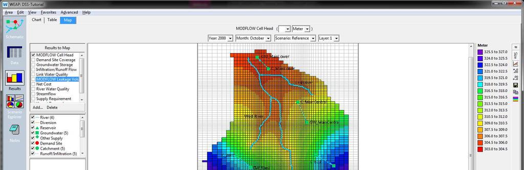
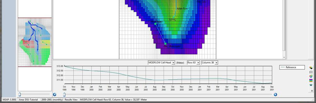
29 Choose your linkage shapefile and assign the respective attribute fields for Row and Column, Groundwater, River Reach and Catchment (this should be correct by default). If you have not yet assigned river reaches (because you opted for Method 2 in chapter 3.8), you should now click on Guess River Point Linkages and Guess Drain Cell Linkages. Click on the results-command and look at the result outputs like the groundwater levels (Supply and Resources Groundwater MODFLOW Cell Head) etc. WEAP-MODFLOW-Tutorial 29/45 Hard-Data-Approach
30 WEAP-MODFLOW-Tutorial 30/45 Hard-Data-Approach
.")
31 4 WEAP-hydrology in linked models Rainfall-Runoff In the previous exercise, you entered groundwater recharge directly into WEAP as Natural Recharge and delimited the catchments according to recharge zones in MODFLOW. In the following exercises, the catchment names remain the same, but they correlate to different spatial regions (surface water catchments). The Catchments are furthermore subdivided into Landuse classes in order to reflect various water needs. In addition, surface-runoff links are assigned to the catchment nodes (from the catchment to the river). In this chapter, WEAP will calculate the groundwater recharge based on its internal Rainfall Runoff (simplified coefficient method) model. 4.1 Add Runoff links to the Schematic In order to let WEAP calculate surface runoff, you need to add runoff-links from catchments to rivers in the WEAP Schematic. Drag and drop a runoff-link from each Catchment Node to its corresponding River. Catchment Runoff link to Headflow yes/no C_MainUpper Main River No C_West West River Yes C_East East River Yes C_Central Main River No C_Main Lower Main River No WEAP-MODFLOW-Tutorial 31/45 Rainfall-Runoff-Model


32 4.2 Assign catchments and Landuse Classes to the Linkage File. 1. Add Sub-branches to each of the Catchments. In the Data-View: right-click on the Catchment Add type the name of the sub branch as specified in the table below: Catchment C_East C_East C_MainCentral C_MainLower C_MainLower C_MainUpper C_MainUpper C_MainUpper C_MainUpper C_West C_West C_West Landuse class unirrigated urban unirrigated unirrigated urban forest irrigated pasture shrub forest pasture unirrigated 2. Switch to LinkKitchen and load the two files Catchment.shp and Landuse.shp as Overlays. 3. Set Layer Catchment to be selectable 4. Set Layer Catchment s Label to Catchment 5. Right click into C_MainUpper and click on Select Cells from Overlay. WEAP-MODFLOW-Tutorial 32/45 Rainfall-Runoff-Model


33 6. Highlight C_MainUpper in the Branch Viewer and click Add Attribute to selected Cells. 7. Highlight GW_MainUpper in the Branch Viewer and click Add Attribute to selected Cells. Repeat steps 5-7 for the other Catchments and Groundwater nodes. 8. Set Layer Landuse selectable and assign Landuse-Classes to the Linkage File. The procedure is similar to steps Send the Area data to WEAP WEAP-MODFLOW-Tutorial 33/45 Rainfall-Runoff-Model


34 4.3 Data input in WEAP Additional inputs at catchment level are precipitation and reference evapotranspiration (ETref). Crop coefficients (Kc) are entered at Landuse class level. These inputs are read into WEAP using the ReadFromFile-function. The file from which to read data is named INPUT_DATA.csv. Copy the file into the TimeSeries-Folder in the WEAP area-directory Enter precipitation 1. In the Data View, select C_MainCentral and activate Climate Precipitation. 2. Click on the arrow besides the data-entry box and select the ReadFromFile Wizard. 3. Open the file \TimeSeries\INPUT_DATA.csv 4. In the lower pane, select the data column Precipitation and click Finish. 5. Repeat steps 2-4 for the other Catchments WEAP-MODFLOW-Tutorial 34/45 Rainfall-Runoff-Model
![4.3.2 Enter ETRef ET Ref is entered the same way as precipitation but with the data column [ET]. 4.3.3 Enter Kc Go to Landuse Kc and enter Kc values for each Landuse Class the same way as precipitation and ET Ref.](/docs-images/73/69586990/images/35-2.jpg "Landuse Classes Irrigated and unirrigated retrieve values from the same data column (unirrigated).")

35 4.3.2 Enter ETRef ET Ref is entered the same way as precipitation but with the data column [ET] Enter Kc Go to Landuse Kc and enter Kc values for each Landuse Class the same way as precipitation and ET Ref. Landuse Classes Irrigated and unirrigated retrieve values from the same data column (unirrigated). (For details on the Rainfall Runoff (simplified coefficient method)-model, see WEAP-help and FAO Irrigation and Drainage Paper No. 56 Crop Evapotranspiration ) Enter Runoff- and Infiltration fractions The total runoff volume can be fractioned to surface runoff and groundwater recharge: Supply and Resources Runoff and Infiltration from catchment (C_...) to Runoff Fraction Enter a value of 50% for each link Run the model and browse the results The result below shows the calculated recharge- and runoff-flows from C_MainLower. WEAP-MODFLOW-Tutorial 35/45 Rainfall-Runoff-Model

36 5 Common tasks The following part of this tutorial will give you some workarounds for dealing with common modeling challenges. It does make no claim to be complete nor does it pretend to show the one-and-only solution for any of the problems presented. But you might use some of the shown approaches as the starting point for your own modeling work. The descriptions hereafter are reduced to the basic implementations and parameter setting. If you want to visualize the impacts of each task on the system, you should apply the changes on scenarios and compare the results with the reference. 5.1 Abstraction for irrigation There are multiple ways to introduce irrigation abstraction. The two most commonly applied ways are: 1. Define a Demand Site and enter the abstracted water directly 2. Let WEAP calculate irrigation demand based on climate and crop parameters For the former, there is no need to care about the climate or what types of crop are grown. This method is easier to implement but very inflexible when it comes to build scenarios. The later requires more data to enter but gives better performance for future planning. The following chapters will show both approaches Add irrigation abstraction by demand site 1. Drag and drop a new demand site onto the Schematic View and name it Irrigation. 2. Drag and drop a transmission link from groundwater GW_MainUpper to the new demand site "Irrigation". 3. Enter the water abstraction for irrigation under: Data Demand sites and catchments irriga@on water use Annual water use The irrigation demand is 30 million m 3 per year. As water is needed only during the months of May and June, the annual irrigation is fractioned with the percentage (40%) in May and (60%) in June. This is entered at WEAP-MODFLOW-Tutorial 36/45 Common Tasks

37 Data Demand sites and catchments irrigation water use Monthly Using the Monthly Time Series Wizard. 4. As WEAP needs to know from which cells to abstract water from, you need to update the Linkage File with that information. It is assumed, that water is abstracted from wells located all over the irrigated area. Switch to LinkKitchen and highlight the Landuse Class C_MainUpper/Irrigated in the Branch Viewer. 5. Click the Select Attributed Cells-Button. 6. Highlight Demand Site Irrigation and click Add Attribute to Linkage File. Now, every cell located within the Landuse Class Irrigated supplies Demand Site Irrigation. 7. Save the Linkage File to disc and go back to WEAP. 8. Re-load the Linkage File if necessary and run WEAP. Browse the results Add irrigation abstraction to a Landuse Class Modelling irrigation demand by a WEAP-internal model requires a connection from groundwater to the catchment. Further specifications, like from which cells to withdraw water and on which cells to apply water, are defined in the Linkage File. The water demand is controlled by the crop parameter Kc and by the climate parameters precipitation and ET. WEAP will calculate water demand, if the plant evapotranspiration is higher than precipitation. WEAP-MODFLOW-Tutorial 37/45 Common Tasks


38 1. Drag and drop a transmission link from GW_MainUpper to C_MainUpper 2. Set the demand priority to 1 3. Switch the irrigated Landuse Class to irrigated: Demand Sites and Catchments C_MainUpper Irrigation Irrigated = 1 4. Run the model and evaluate the results in the results view. E.g. Land class inflows and outflows: You can see irrigation takeing place during the months May and June when ET is high and precipitation is low. Although precipitation remains low during July and August, there is no need to irrigate as the crops are already harvested. WEAP-MODFLOW-Tutorial 38/45 Common Tasks


39 5.2 Changes in Land Use The purpose of this exercise is to investigate the impact of changes in land use on the groundwater recharge. In order to emphasize the changes, the total runtime of the model is extruded to 10 years. General. Years steps last year of scenarios = 2009 Land use 2000 Land use Urbanization Storyline: Urban areas grow towards extending over the entire catchment areas of C_East and C_MainLower until Infiltration vanishes and the entire precipitation runs off the rivers. 1. Let WEAP repeat time-dependant data each year (precipitation, ET, Kc): Chose cycle - option WEAP-MODFLOW-Tutorial 39/45 Common Tasks
 and Remainder(100).")
40 2. Increase the surface runoff fraction from 50% in the year 2000 to 100% in 2009 and reduce the fraction for groundwater recharge accordingly: Supply and Resources Runoff and from C_MainLower Runoff Supply and Resources Runoff and Infiltration from C_E ast Runoff To interpolate the yearly fractions use the functions Interp(2009, 100) and Remainder(100). Runoff Fraction (monthly) to GW_MainLower to Catchment Inflow Node % share Oct Feb Jun Oct Feb Jun Oct Feb Jun Oct Feb Jun Oct Feb Jun Oct Feb Jun Oct Feb Jun Oct Feb Jun Oct Feb Jun Oct Feb Jun Irrigation growth Land use class unirrigated is changed to be irrigated from the year 2001 onward. 1. Add transmission links from the groundwater to the catchment for the catchments C_MainUpper, C_MainCentral and C_West. 2. Within these catchments, set the land use classes unirrigated and irrigated to be irrigated (1) 3. Define an irrigation fraction of 75% (= overirrigation) 4. Run the model and browse the results WEAP-MODFLOW-Tutorial 40/45 Common Tasks
")
41 5.3 Domestic water supply from well fields In this chapter, you will introduce two domestic demand sites (City1 & City2), which are supplied by local well fields. You need to make entries in both WEAP and the Linkage File for this to work. 1. Drag and drop two Demand Sites (City 1 and City 2) onto the Schematic. 2. Add a Transmission link from GW_MainUpper to City 1 and another transmission link from GW_MainLower to City Set the Annual Water Use Rate for both Cities to 20 Million m³. 4. Set the Consumption to 100%: Demand Sites and Catchments Water Use Consump@on 5. Switch to LinkKitchen and load the overlay-layer Wellfields.shp which indicates the location of the two wellfields. 6. Select all cells of the top wellfields first and assign City 2 to the selected cells. Repeat the step with the second wellfield. The preview should look like: 7. Save the Linkage File and reload it WEAP-MODFLOW-Tutorial 41/45 Common Tasks
")

42 into WEAP if necessary. 8. Run WEAP and browse for Cell-Head-results (Map-View) The result shows a significant cone of depression around the cells you defined as Demand Site City2. WEAP-MODFLOW-Tutorial 42/45 Common Tasks

43 5.4 Artificial groundwater recharge Modelling artificial recharge (e.g. injection wells) is similar to modelling abstraction. The only difference is that water is not consumed by the demand site but returned to a groundwater node. The location of the injection is defined by the demand-attribute in the Linkage File. 1. Add a Demand Site Artificial Recharge to the Schematic and set Annual Water Use Rate to 20 Million m³; set Consumption to 0% 2. Add a Transmission link from Main River to the new Demand Site and a Return Flow Link from the Demand Site to groundwater GW_MainLower 3. Switch to LinkKitchen and link some cells to Demand Site ArtificialRecharge. The preview should look similar to the image below: 4. Save the Linkage File and go back to WEAP 5. Browse to the Cell-Head-results WEAP-MODFLOW-Tutorial 43/45 Common Tasks


44 Injecting water has a similar effect on the groundwater table as withdrawal but in the opposite direction. The effects of withdrawal and artificial recharge are visualized in the Map Window and as 3D-chart (s. images below left and bottom). Image below right shows the annual flows as calculated by WEAP. WEAP-MODFLOW-Tutorial 44/45 Common Tasks

 Precipitation Growth (-3%) Run WEAP and browse to the result for groundwater storage.")
45 5.5 Climate Change The possible impacts of climate change on surface runoff, groundwater levels and spring flow are (at a simplistic glance on that complex subject) driven by changes in the parameters precipitation and evaporation. In order to visualize the impacts of climate change, create a new scenario Climate Change and change the following parameters for every single catchment: ET Ref Growth(3%) Precipitation Growth (-3%) Run WEAP and browse to the result for groundwater storage. The comparison of the two scenarios climate change and reference shows the effect of climate change on groundwater storage over time WEAP-MODFLOW-Tutorial 45/45 Common Tasks
WEAP. Water Evaluation And Planning System. Tutorial. A collection of stand-alone modules to aid in learning the WEAP software
 WEAP Water Evaluation And Planning System Tutorial A collection of stand-alone modules to aid in learning the WEAP software WEAP Water Evaluation And Planning System Tutorial Modules Tutorial Overview...
Learn how to design inlet grates, detention basins, channels, and riprap using the FHWA Hydraulic Toolbox and WMS
 v. 11.0 WMS 11.0 Tutorial Learn how to design inlet grates, detention basins, channels, and riprap using the FHWA Hydraulic Toolbox and WMS Objectives Learn how to use several Hydraulic Toolbox calculators
WMS 9.1 Tutorial Storm Drain Modeling Storm Drain: Hydrographic Design Learn how to run sub-basin hydrographs through a storm drain network
 v. 9.1 WMS 9.1 Tutorial Storm Drain Modeling Storm Drain: Hydrographic Design Learn how to run sub-basin hydrographs through a storm drain network Objectives Build a rational method model and compute sub-basin
WMS 8.4 Tutorial Storm Drain Modeling Storm Drain: Hydrographic Design Learn how to run sub-basin hydrographs through a storm drain network
 v. 8.4 WMS 8.4 Tutorial Storm Drain Modeling Storm Drain: Hydrographic Design Learn how to run sub-basin hydrographs through a storm drain network Objectives Build a rational method model and compute sub-basin
Chapter 1 Introduction
 Engineering Hydrology Chapter 1 Introduction 2016-2017 Hydrologic Cycle Hydrologic Cycle Processes Processes Precipitation Atmospheric water Evaporation Infiltration Surface Runoff Land Surface Soil water
Model objectives. Main features. Water Evaluation And Planning (WEAP)
") Water Evaluation And Planning (WEAP) Model objectives WEAP ( Water Evaluation And Planning system) is a userfriendly software tool that fully integrates water supply, demand, water quality and ecological
Water Evaluation And Planning (WEAP) Model objectives WEAP ( Water Evaluation And Planning system) is a userfriendly software tool that fully integrates water supply, demand, water quality and ecological
1 THE USGS MODULAR MODELING SYSTEM MODEL OF THE UPPER COSUMNES RIVER
 1 THE USGS MODULAR MODELING SYSTEM MODEL OF THE UPPER COSUMNES RIVER 1.1 Introduction The Hydrologic Model of the Upper Cosumnes River Basin (HMCRB) under the USGS Modular Modeling System (MMS) uses a
Water Evaluation And Planning System USER GUIDE
 Water Evaluation And Planning System USER GUIDE WEAP Water Evaluation And Planning System USER GUIDE for WEAP 2015 Jack Sieber, M.S., Water Systems Modeler David Purkey, Ph.D., Director, SEI-US Water
Developing Decision Support System (DSS) for Integrated Water Resources Management (IWRM)
 for Integrated Water Resources Management (IWRM)") Department of Water Resources Studies Success Stories: Developing Decision Support System (DSS) for Integrated Water Resources Management (IWRM) The situation of the water supply in the Arab region is
Department of Water Resources Studies Success Stories: Developing Decision Support System (DSS) for Integrated Water Resources Management (IWRM) The situation of the water supply in the Arab region is
PONDS 3.2 Technical Memo SUBJECT:
 PONDS 3.2 Technical Memo SUBJECT: MODELING MULTIBASIN / INTERCONNECTED PONDS Date: January 21, 2008 The following memo discusses the Multibasin SCS hydrograph in the PONDS 3.2 Refined Method software,
CONTINUOUS RAINFALL-RUN OFF SIMULATION USING SMA ALGORITHM
 CONTINUOUS RAINFALL-RUN OFF SIMULATION USING SMA ALGORITHM INTRODUCTION Dr. R N Sankhua Director, NWA, CWC, Pune In this continuous rainfall-runoff simulation, we will perform a continuous or long-term
Water Security for Central Kosovo
 WEAP Model Activities Ministry of Environment and Spatial Planning World Bank Water Security for Central Kosovo March 2011 TABLE OF CONTENTS I. General Presentation of WEAP model...10 II. Introduction
Comparative analysis of SWAT model with Coupled SWAT-MODFLOW model for Gibbs Farm Watershed in Georgia
 2018 SWAT INTERNATIONAL CONFERENCE, JAN 10-12, CHENNAI 1 Comparative analysis of SWAT model with Coupled SWAT-MODFLOW model for Gibbs Farm Watershed in Georgia Presented By K.Sangeetha B.Narasimhan D.D.Bosch
BASINS EXERCISE. 2) Select the Locate your Watershed webpage (located at:
 Select the Locate your Watershed webpage (located at:") BASINS EXERCISE Overview This exercise was created for the Fox-Wolf Watershed Alliance - Stormwater 2003 Conference. Funding was provided by the University of Wisconsin Sea Grant Institute and UW Land
BASINS EXERCISE Overview This exercise was created for the Fox-Wolf Watershed Alliance - Stormwater 2003 Conference. Funding was provided by the University of Wisconsin Sea Grant Institute and UW Land
Hydrology and Water Management. Dr. Mujahid Khan, UET Peshawar
 Hydrology and Water Management Dr. Mujahid Khan, UET Peshawar Course Outline Hydrologic Cycle and its Processes Water Balance Approach Estimation and Analysis of Precipitation Data Infiltration and Runoff
WWHM4 MODELING USING NATIONAL MAP
 WWHM4 MODELING USING NATIONAL MAP Clear Creek Solutions, Inc., 2010 How to create a project that uses national data. WWHM4 is one of the most powerful continuous simulation hydrologic models available.
KanSched2. An ET-Based Irrigation Scheduling Tool. October 2006
 KanSched2 An ET-Based Irrigation Scheduling Tool October 2006 Danny H. Rogers and Mahbub Alam Biological and Agricultural Engineering K-State Research and Extension KanSched 2.0 is a program that is designed
A WEAP Model of the Kinneret Basin
 A WEAP Model of the Kinneret Basin Illy Sivan 1, Yigal Salingar 1 and Alon Rimmer 2 This is an English translation of the article that originally appeared in Sivan, I., Y. Salingar, and A. Rimmer, A WEAP
4.4 MODEL CODE DESCRIPTION 4.5 WATER SOURCES AND SINKS 4.6 MODEL DOMAIN AND BOUNDARIES. SLR South Africa
 Page 4-18 The developed model should therefore be seen as an initial site model which should be refined and recalibrated once more groundwater monitoring and other data become available. 4.4 MODEL CODE
A Decision Support System for Water Management
 A Decision Support System for Water Management Droubi, A., Al-Sibai, M., Abdallah, A., Mahamed, J., Shahabi, O., Zahra, S. & Obeissi, M. (ACSAD) Wolfer, J., Huber, M. & Hennings, V. (BGR) ARAB GERMAN TECHNICAL
Feasibility Study of Artificial Aquifer Recharge in the Walla Walla Basin. Presenter: Arístides Petrides
 Feasibility Study of Artificial Aquifer Recharge in the Walla Walla Basin Presenter: Arístides Petrides Overview of Presentation Background Walla Walla River Basin Previous Modeling Effort with IWFM New
CHAPTER 7 GROUNDWATER FLOW MODELING
 148 CHAPTER 7 GROUNDWATER FLOW MODELING 7.1 GENERAL In reality, it is not possible to see into the sub-surface and observe the geological structure and the groundwater flow processes. It is for this reason
GRACE: Tracking Water from Space. Groundwater Storage Changes in California s Central Valley Data Analysis Protocol for Excel: PC
 Groundwater Storage Changes in California s Central Valley Data Analysis Protocol for Excel: PC 2007-10 Before GRACE it was very difficult to estimate how the total volumes of groundwater are changing.
Scale Effects in Large Scale Watershed Modeling
 Scale Effects in Large Scale Watershed Modeling Mustafa M. Aral and Orhan Gunduz Multimedia Environmental Simulations Laboratory School of Civil and Environmental Engineering Georgia Institute of Technology
Sixth Semester B. E. (R)/ First Semester B. E. (PTDP) Civil Engineering Examination
/ First Semester B. E. (PTDP) Civil Engineering Examination") CAB/2KTF/EET 1221/1413 Sixth Semester B. E. (R)/ First Semester B. E. (PTDP) Civil Engineering Examination Course Code : CV 312 / CV 507 Course Name : Engineering Hydrology Time : 3 Hours ] [ Max. Marks
CAB/2KTF/EET 1221/1413 Sixth Semester B. E. (R)/ First Semester B. E. (PTDP) Civil Engineering Examination Course Code : CV 312 / CV 507 Course Name : Engineering Hydrology Time : 3 Hours ] [ Max. Marks
Irrigation modeling in Prairie Ronde Township, Kalamazoo County. SW Michigan Water Resources Council meeting May 15, 2012
 Irrigation modeling in Prairie Ronde Township, Kalamazoo County SW Michigan Water Resources Council meeting May 15, 2012 Development of a Groundwater Flow Model INFLOWS Areal recharge from precipitation
Assessment of the Groundwater Quantity Resulting from Artificial Recharge by Ponds at Ban Nong Na, Phitsanulok Province, Thailand
 Research article erd Assessment of the Groundwater Quantity Resulting from Artificial Recharge by Ponds at Ban Nong Na, Phitsanulok Province, Thailand SIRIRAT UPPASIT* Faculty of Technology, Khon Kaen
Wetland Water Balance Linking hydrogeological processes to ecological effect
 Wetland Water Balance Linking hydrogeological processes to ecological effect Don Ross & David Gasca Outline Background Wetland-scale processes Water balance approach Hydrogeological inputs & ecological
The Corning Primary Aquifer -One of 18. NYSDEC Primary Aquifers in New York
 The Corning Primary Aquifer -One of 18 NYSDEC Primary Aquifers in New York NYSDEC Primary and Principal Aquifers PRIMARY AQUIFERS (18) Highly productive aquifers presently being utilized by major municipal
2
 1 2 3 4 5 6 The program is designed for surface water hydrology simulation. It includes components for representing precipitation, evaporation, and snowmelt; the atmospheric conditions over a watershed.
GROUNDWATER Dr. DEEPAK KHARE GENERAL HYDROLOGY CYCLE FORMATIONS
 GROUNDWATER By Dr. DEEPAK KHARE Associate Professor Department of Water Resources Development & Management Indian Institute of Technology Roorkee, ROORKEE (Uttaranchal) 247 667, India E-mail: kharefwt@iitr.ernet.in
Excel 2011 Charts - Introduction Excel 2011 Series The University of Akron. Table of Contents COURSE OVERVIEW... 2
 Table of Contents COURSE OVERVIEW... 2 DISCUSSION... 2 OBJECTIVES... 2 COURSE TOPICS... 2 LESSON 1: CREATE A CHART QUICK AND EASY... 3 DISCUSSION... 3 CREATE THE CHART... 4 Task A Create the Chart... 4
INTRODUCTION TO YANQI BASIN CASE STUDY (CHINA) Wolfgang Kinzelbach, Yu Li ETH Zurich, Switzerland
 Wolfgang Kinzelbach, Yu Li ETH Zurich, Switzerland") INTRODUCTION TO YANQI BASIN CASE STUDY (CHINA) Wolfgang Kinzelbach, Yu Li ETH Zurich, Switzerland Outline Study area - Hydrological regime - Problems - Sustainability in Yanqi Distributed numerical model
INTRODUCTION TO YANQI BASIN CASE STUDY (CHINA) Wolfgang Kinzelbach, Yu Li ETH Zurich, Switzerland Outline Study area - Hydrological regime - Problems - Sustainability in Yanqi Distributed numerical model
CHAPTER FIVE Runoff. Engineering Hydrology (ECIV 4323) Instructors: Dr. Yunes Mogheir Dr. Ramadan Al Khatib. Overland flow interflow
 Instructors: Dr. Yunes Mogheir Dr. Ramadan Al Khatib. Overland flow interflow") Engineering Hydrology (ECIV 4323) CHAPTER FIVE Runoff Instructors: Dr. Yunes Mogheir Dr. Ramadan Al Khatib Overland flow interflow Base flow Saturated overland flow ١ ٢ 5.1 Introduction To Runoff Runoff
Engineering Hydrology (ECIV 4323) CHAPTER FIVE Runoff Instructors: Dr. Yunes Mogheir Dr. Ramadan Al Khatib Overland flow interflow Base flow Saturated overland flow ١ ٢ 5.1 Introduction To Runoff Runoff
Information Technology Solutions
 Connecting People, Process Information & Data Network Create Systems Workflow Diagnostic Jumps Testing Information Technology Solutions in Workflow Connect Prior Learning It is helpful but not essential
Effects of irrigation on groundwater recharge under deep buried depth condition
 IOP Conference Series: Earth and Environmental Science PAPER OPEN ACCESS Effects of on groundwater recharge under deep buried depth condition To cite this article: DONG Qiguang et al 2017 IOP Conf. Ser.:
TECHNOSOFT, INC. Inquest Version 5. QuickBooks Data Sharing
 TECHNOSOFT, INC. Inquest Version 5 QuickBooks Data Sharing INQUEST VERSION 5 QuickBooks Data Sharing TECHNOSOFT, INC. 71 WENDY LN SOUTH KINGSTOWN, RI 02879 401.284.2959 www.technosoftinc.com 2002-2008
Water Evaluation And Planning System USER GUIDE
 Water Evaluation And Planning System USER GUIDE WEAP Water Evaluation And Planning System USER GUIDE for WEAP21 Jack Sieber, M.S., Water Systems Modeler David Purkey, Ph.D., Director, SEI-US Water Program
CHAPTER ONE : INTRODUCTION
 CHAPTER ONE : INTRODUCTION WHAT IS THE HYDROLOGY? The Hydrology means the science of water. It is the science that deals with the occurrence, circulation and distribution of water of the earth and earth
Preface. Riparian Wetland Restoration Site Selection Using GIS
 Riparian Wetland Restoration Site Selection Using GIS i Preface This bulletin is intended as a guide for managers, planners, and policy-makers involved in wetland restoration projects. This step-by-step
WMS Tools For Computing Hydrologic Modeling Parameters
 WMS Tools For Computing Hydrologic Modeling Parameters Lesson 9 9-1 Objectives Use the drainage coverage as a basis for geometric parameters as well as overlaying coverages to compute important hydrologic
Lab 5: Watershed hydrology
 Lab 5: Watershed hydrology Objectives In this lab, you will learn the fundamentals of flow routing and channel network extraction, and analyze precipitation and discharge data to explore the control of
WMS 9.0 Tutorial GSSHA Applications Simulating Constituent Transport Model constituent transport in GSSHA
 v. 9.0 WMS 9.0 Tutorial GSSHA Applications Simulating Constituent Transport Model constituent transport in GSSHA Objectives Develop input parameters for and run a long-term model that simulates constituent
Predicting Unmet Irrigation Demands due to Climate Change An integrated Approach in WEAP
 Predicting Unmet Irrigation Demands due to Climate Change An integrated Approach in WEAP Marc Haering Emad Al-Karablieh, Amer Salman University of Jordan G-Wadi International Session 5: Risks Assessment
river modelling keeping low flows in mind
 Incorporating surfacegroundwater interactions into river modelling keeping low flows in mind David Rassam 11 February 2013 CSIRO LAND WATER; WATER FOR A HEALTHY COUNTRY FLAGSHIP Outline of presentation
PAYGLOBAL EXPLORER USER GUIDE
 PAYGLOBAL EXPLORER USER GUIDE Table of Contents Revised March 2002 by Ian Johnson (PayGlobal Pty Ltd) to include changes for rate over-rides and breaks. Revised June 2002 by Ian Johnson (PayGlobal Pty
Digital Production Control - Timekeeping
 Digital Production Control - Timekeeping This Quick Start Guide is designed to augment the DPC Project Manager and Foreman Quick Start Guides. In those guides, you are taught how to setup DPC jobs, send/receive
Groundwater Recharge from Wala Dam Reservoir in Jordan
 Groundwater Recharge from Wala Dam Reservoir in Jordan Abbas Z. Ijam Hamed Raja Alnaimat Civil and Environmental Engineering Department Faculty of Engineering, Mutah University, Mutah, Jordan e-mail: abbasa@mutah.edu.jo
Lecture 9A: Drainage Basins
 GEOG415 Lecture 9A: Drainage Basins 9-1 Drainage basin (watershed, catchment) -Drains surfacewater to a common outlet Drainage divide - how is it defined? Scale effects? - Represents a hydrologic cycle
Comparison of Streamflow and Precipitation in the Upper Provo River Watershed
 Comparison of Streamflow and Precipitation in the Upper Provo River Watershed By: Steven McKee CEE 6440 GIS in Water Resources Final Project 12/6/2012 0 Table of Contents Introduction... 2 Methods to Determine
General Groundwater Concepts
 General Groundwater Concepts Hydrologic Cycle All water on the surface of the earth and underground are part of the hydrologic cycle (Figure 1), driven by natural processes that constantly transform water
HYDROLOGICAL IMPACTS OF IRAQI BADUSH DAM ON GROUNDWATER
 HYDROLOGICAL IMPACTS OF IRAQI BADUSH DAM ON GROUNDWATER AQEEL Al-ADILI 1, SALEH KHASAF 2 AND AWS AJAJ 3 1 University of Technology, P.O. Box; 4627, Baghdad, Iraq, e-mail; aqeeladili@hotmail.com 2 University
Groundwater Review Assistant (GWRA) User Guide
 User Guide") Groundwater Review Assistant (GWRA) User Guide Table of Contents 1. INTRODUCTION... 2 2. DISCLAIMER AND LIMITATIONS... 2 3. QUICK START GUIDE... 3 4. GROUNDWATER REVIEW ASSISTANT USER INFORMATION... 4
Groundwater Review Assistant (GWRA) User Guide Table of Contents 1. INTRODUCTION... 2 2. DISCLAIMER AND LIMITATIONS... 2 3. QUICK START GUIDE... 3 4. GROUNDWATER REVIEW ASSISTANT USER INFORMATION... 4
The Spreadsheet Tool for Estimating Pollutant Load (STEPL)
") The Spreadsheet Tool for Estimating Pollutant Load (STEPL) Introduction to STEPL March 20, 2018 Webinar Logistics To ask a question Type your question in the Q&A tool box on the right side of your screen
The Spreadsheet Tool for Estimating Pollutant Load (STEPL) Introduction to STEPL March 20, 2018 Webinar Logistics To ask a question Type your question in the Q&A tool box on the right side of your screen
Song Lake Water Budget
 Song Lake Water Budget Song Lake is located in northern Cortland County. It is a relatively small lake, with a surface area of about 115 acres, and an average depth of about 14 feet. Its maximum depth
DYNFLOW accepts various types of boundary conditions on the groundwater flow system including:
 Section 6 Groundwater Flow Model A groundwater flow model was developed to evaluate groundwater flow patterns in the site area and to provide a basis for contaminant transport modeling. 6.1 Model Code
DRM DISPATCHER USER MANUAL
 DRM DISPATCHER USER MANUAL Overview: DRM Dispatcher provides support for creating and managing service appointments. This document describes the DRM Dispatcher Dashboard and how to use it to manage your
Purpose. Utilize groundwater modeling software to forecast the pumping drawdown in a regional aquifer for public drinking water supply
 MODFLOW Lab 19: Application of a Groundwater Flow Model to a Water Supply Problem An Introduction to MODFLOW and SURFER The problem posed in this lab was reported in Chapter 19 of "A Manual of Instructional
Investigation of sustainable development potential for Ulubey Aquifer System, Turkey
 doi:10.5194/piahs-364-513-2014 Evolving Water Resources Systems: Understanding, Predicting and Managing Water Society Interactions Proceedings of ICWRS2014, Bologna, Italy, June 2014 (IAHS Publ. 364, 2014).
Stream hydrographs. Stream hydrographs. Baseflow. Graphs of river stage or discharge at a single location as a function of time
 Stream hydrographs Graphs of river stage or discharge at a single location as a function of time Hydrologic og budget Discharge: units? How is it measured? Show fluctuating water levels in response to
Understanding Earth Fifth Edition
 Understanding Earth Fifth Edition Grotzinger Jordan Press Siever Chapter 17: THE HYDROLOGIC CYCLE AND GROUNDWATER Lecturer: H Mohammadzadeh Assistant professors, Department of Geology, FUM Copyright 2007
L-THIA GIS Manual. (Long-Term Hydrologic Impact Assessment) By Youn Shik Park, Kyoung Jae Lim, Larry Theller, Bernie A. Engel
 By Youn Shik Park, Kyoung Jae Lim, Larry Theller, Bernie A. Engel") L-THIA GIS Manual (Long-Term Hydrologic Impact Assessment) By Youn Shik Park, Kyoung Jae Lim, Larry Theller, Bernie A. Engel Manual version: May 6 th 2013 Department of Agricultural and Biological Engineering
L-THIA GIS Manual (Long-Term Hydrologic Impact Assessment) By Youn Shik Park, Kyoung Jae Lim, Larry Theller, Bernie A. Engel Manual version: May 6 th 2013 Department of Agricultural and Biological Engineering
RUNNING WATER AND GROUNDWATER
 NAME RUNNING WATER AND GROUNDWATER I. Introduction In this exercise we will investigate various features associated with streams and groundwater. Our drinking water ultimately comes from either streams
Introduction to Hydrological Models. University of Oklahoma/HyDROS Module 1.2
 Introduction to Hydrological Models University of Oklahoma/HyDROS Module 1.2 Outline Day 1 WELCOME INTRODUCTION TO HYDROLOGICAL MODELS The water cycle Defining hydrological processes Modeling hydrological
BI Workspaces User Guide SAP BusinessObjects Business Intelligence platform 4.0
 BI Workspaces User Guide SAP BusinessObjects Business Intelligence platform 4.0 Copyright 2011 SAP AG. All rights reserved.sap, R/3, SAP NetWeaver, Duet, PartnerEdge, ByDesign, SAP Business ByDesign, and
 5. MODEL DESCRIPTION Several models were used in combination to estimate the impacts of the proposed 100,000 acre-ft dryyear yield program. MODFLOW and MODPATH were used to estimate the groundwater and
AASHTOWare BrD 6.8 Substructure Tutorial Solid Shaft Pier Example
 AASHTOWare BrD 6.8 Substructure Tutorial Solid Shaft Pier Example Sta 4+00.00 Sta 5+20.00 (Pier Ref. Point) Sta 6+40.00 BL SR 123 Ahead Sta CL Brgs CL Pier CL Brgs Bridge Layout Exp Fix Exp CL Brgs Abut
Welcome to the Project Manager guide
 Contents Getting around... 3 Creating a new project... 4 Selecting an existing project... 6 Dashboards... 6 Project planning... 9 Project roles... 9 Gantt view... 11 Adding a task in Gantt view... 12 Parent
DIGITAL VERSION. Microsoft EXCEL Level 2 TRAINER APPROVED
 DIGITAL VERSION Microsoft EXCEL 2013 Level 2 TRAINER APPROVED Module 4 Displaying Data Graphically Module Objectives Creating Charts and Graphs Modifying and Formatting Charts Advanced Charting Features
New World Technologies, Inc Invoice Importer
 New World Technologies, Inc Invoice Importer The Invoice Importer is a tool that allows users of QuickBooks Pro, Premier, Accountant's and Enterprise editions 2010 or greater to import Invoices, Sales
SEAWAT Concentration and Temperature Effects
 v. 10.4 GMS 10.4 Tutorial Examine Concentration and Temperature Impacts on Fluid Density with SEAWAT Objectives Learn how to simulate the effects of concentration and temperature on fluid density with
Module 2 Measurement and Processing of Hydrologic Data
 Module 2 Measurement and Processing of Hydrologic Data 2.1 Introduction 2.1.1 Methods of Collection of Hydrologic Data 2.2 Classification of Hydrologic Data 2.2.1 Time-Oriented Data 2.2.2 Space-Oriented
Evaluating the use of DHI software MIKE Basin to optimize the water use in Malaprabha catchment area in Karnataka, India.
 Evaluating the use of DHI software MIKE Basin to optimize the water use in Malaprabha catchment area in Karnataka, India. Technical Brief 1 Technical Briefs are short summaries of models used in the project
Modeling the Managed Aquifer Recharge for Groundwater Salinity Management in the Sokh River Basin
 Modeling the Managed Aquifer Recharge for Groundwater Salinity Management in the Sokh River Basin A. Karimov, 1 I. Gracheva, 2 F. Miryusupov 2 1 International Water Management Institute (IWMI) Central
Getting Started with OptQuest
 Getting Started with OptQuest What OptQuest does Futura Apartments model example Portfolio Allocation model example Defining decision variables in Crystal Ball Running OptQuest Specifying decision variable
1. Open Excel and ensure F9 is attached - there should be a F9 pull-down menu between Window and Help in the Excel menu list like this:
 This is a short tutorial designed to familiarize you with the basic concepts of creating a financial report with F9. Every F9 financial report starts as a spreadsheet and uses the features of Microsoft
MS Project 2007 Overview Table of Contents
 Table of Contents Microsoft Project Overview... 1 Terminology... 1 Starting Microsoft Project... 2 Projects on the Web... 2 Toolbars... 2 View Bar... 2 Views... 3 Setting Up the Project... 3 Identifying
TABLE OF CONTENTS DOCUMENT HISTORY
 TABLE OF CONTENTS DOCUMENT HISTORY 5 UPDATE 17D 5 Revision History 5 Overview 5 Optional Uptake of New Features (Opt In) 6 Update Tasks 6 Feature Summary 7 Demand Management 9 Forecast Unique Demand Segments
How do I Reconcile MCPS Invoices?
 How do I Reconcile MCPS Invoices? Overview Purpose This document explains how schools can reconcile Montgomery County Public School (MCPS) invoices to requisitions charged to their cash account and to
KanSched2. General Overview. An ET-Based Irrigation Scheduling Tool
 KanSched2 An ET-Based Irrigation Scheduling Tool Danny H. Rogers and Mahbub Alam Biological and Agricultural Engineering K-State Research and Extension KanSched2 is a program designed to help monitor the
Or, from the View and Manage RFx(s) page, click the Create RFx button. Create New RFx - Use this button to create an RFQ from scratch.
 page, click the Create RFx button. Create New RFx - Use this button to create an RFQ from scratch.") Request for Quote How to Create Create an RFQ To create any RFx (RFI, RFQ, RFP, Auction or Buyer Survey), from the View and Manage RFx(s) page, click on the Create RFx button. Follow the steps below to
Request for Quote How to Create Create an RFQ To create any RFx (RFI, RFQ, RFP, Auction or Buyer Survey), from the View and Manage RFx(s) page, click on the Create RFx button. Follow the steps below to
Getting Started Guide
 Getting Started Guide OAS Freight v 3.2 Welcome Thank you for selecting OAS Freight. This guide is designed to help you become familiar with the OAS Freight software. This guide is not designed to be a
Purchase Order, Requisitions, Inventory Hands On. Workshop: Purchase Order, Requisitions, Inventory Hands On
 Workshop: Purchase Order, Requisitions, Inventory Hands In this follow up session to the Operations Changes in Purchase Order, Requisition, and Inventory Theory course, this hands on session will look
CHAPTER 2. Objectives of Groundwater Modelling
 CHAPTER 2 Objectives of Groundwater Modelling In the last two decades mathematical modelling techniques have increasingly proved their value in furthering the understanding of groundwater systems and,
SUPPLEMENTS MANAGEMENT PROGRAM v2.1 Administrator User Guide. Table of contents
 1 SUPPLEMENTS MANAGEMENT PROGRAM v2.1 Administrator User Guide Table of contents Menu Functions Page(s) Pay dates 2-4 Category / Subcategory 5-7 Organizations 7-8 Program Settings 8-9 User Management 10-11
Hiring - Pre-Selection
 Hiring - Pre-Selection Contents Page 3 Page 4 Page 5 Page 6 Page 6-7 Page 7-9 Page 7 Page 8 Page 8-9 Page 10-12 The Hiring Process Candidate Selection Page - Overview Display Candidates Page - Overview
Supervisor Web Services Training Guide For. Aquinas College
 Supervisor Web Services Training Guide For Aquinas College This is an overview of all the employees assigned to the supervisor that is currently logged in. This screen is also a quick reference to check
Scheduling Work at IPSC
 Scheduling Work at IPSC Overview The purpose of this document is to describe and lay out the specific steps for how Work Orders will be scheduled in Maximo at IPSC. In general, Work Orders will be planned
Documentation of Groundwater Agent-based Model
 Documentation of Groundwater Agent-based Model Comments or suggestions to 1. Introduction In environmental resources management there is the recognition of need for combined socio-environmental
Hydrogeology 101 3/7/2011
 Hydrogeology 101 W. Richard Laton, Ph.D., PG, CPG Associate Professor of Hydrogeology California State University, Fullerton Department of Geological Sciences 1 Hydrogeology 101 The objective is to obtain
HYDROLOGY - BASIC CONCEPTS
 HYDROLOGY - BASIC CONCEPTS Hydrology Hydrology is the science of the waters of the earth and its atmosphere. It deals with occurrence, circulation, distribution and movements of these waters over the globe
Module 5 Timesheet. Step by Step Guide PSA Suite Basic for CRM Timesheet calendar view 5.2 Timer 5.3 Timesheet by line
 Step by Step Guide PSA Suite Basic for CRM 2013 Module 5 5.1 calendar view 5.2 Timer 5.3 by line PSA Suite Basic CRM 2013: V1.0 1 Module 5. Contents TIMESHEET CALENDAR VIEW... 5 INTRODUCTION... 5 1. Objectives...
A GROUNDWATER ARTIFICIAL RECHARGE MANAGEMENT TOOL: A CASE STUDY OF THE DRAVA RIVER IN MARIBOR, SLOVENIA
 River Basin Management IX 85 A GROUNDWATER ARTIFICIAL RECHARGE MANAGEMENT TOOL: A CASE STUDY OF THE DRAVA RIVER IN MARIBOR, SLOVENIA IRENA KOPAČ, MATEVŽ VREMEC & MIHA KRAČUN IEI Institute for Ecological
Findmyshift - Getting started with Findmyshift
 Findmyshift - Getting started with Findmyshift Managers Creating your first schedule Adding employees to your team Inviting your employees to log in Choosing your settings Entering shifts Publishing shifts
Hydrological design of flood reservoirs by utilization of GIS and remote sensing
 Remote Sensing and Geographic Information Systems for Design and Operation of Water Resources Systems (Proceedings of Rabat Symposium S3, April 1997). IAHS Publ. no. 242, 1997 173 Hydrological design of
V9 Jobs and Workflow Administrators Guide DOCUMENTATION. Phone: Fax:
 V9 Jobs and Workflow Administrators Guide DOCUMENTATION Phone: 01981 590410 Fax: 01981 590411 E-mail: information@praceng.com CHANGE HISTORY ORIGINAL DOCUMENT AUTHOR: MICHELLE HARRIS DATE: APRIL 2010 AUTHOR
Hydrologic Modeling Overview
 Hydrologic Modeling Overview Chuck Downer, PhD, PE, PMP #MIG TM Hydrologic Systems Branch Coastal and Hydraulics Laboratory Engineer Research and Development Center Vicksburg, Mississippi 1. Hydrologic
Physically-based Distributed Hydrologic Modeling
 Physically-based Distributed Hydrologic Modeling Goal of Phys.-based Distrib. Hydrologic Modeling To date we have learned about: Key forcings at land surface (precipitation/net radiation) Physical processes
Representing the Integrated Water Cycle in Community Earth System Model
 Representing the Integrated Water Cycle in Community Earth System Model Hong-Yi Li, L. Ruby Leung, Maoyi Huang, Nathalie Voisin, Teklu Tesfa, Mohamad Hejazi, and Lu Liu Pacific Northwest National Laboratory
TOPMODEL. Download Information Availability: Nonproprietary, (http://www.es.lancs.ac.uk/hfdg/topmodel.html) Cost: None for non-commercial uses.
 Cost: None for non-commercial uses.") TOPMODEL Contact Information Keith Beven Department of Environmental Science Institute of Environmental and Natural Sciences Lancaster University Lancaster LA1 4YQ United Kingdom +44 (0)1524 593892 K.Beven@lancaster.ac.uk
TOPMODEL Contact Information Keith Beven Department of Environmental Science Institute of Environmental and Natural Sciences Lancaster University Lancaster LA1 4YQ United Kingdom +44 (0)1524 593892 K.Beven@lancaster.ac.uk