Trends in Illinois River Streamflow and Flooding
|
|
|
- Barbra Shepherd
- 6 years ago
- Views:
Transcription


1 Trends in Illinois River Streamflow and Flooding H. Vernon Knapp, Interim Director Center for Watershed Science Illinois State Water Survey Institute of Natural Resource Sustainability University of Illinois at Urbana-Champaign
2 Selected recommendations from the Illinois River Integrated Management Plan Determine the contribution of changing precipitation patterns to streamflow trends Conduct analysis to examine why the frequency of major floods is increasing Establish goals for water yields
3 Illinois River at Kingston Mines, Peak flow (cubic feet per second) Source: Ramamurthy, Singh and Terstriep (1989)
4 Peak flow (cubic feet per second)
5 Peak flow (cubic feet per second)
6 Peak flow (cubic feet per second) ? Which trend do you believe???


7 Evaluation of Streamflow Trends Highly dependent on period of years analyzed Hydrologic and climatic records experience considerable inter-decadal variability Most observed trends are not based on factors that are highly predictable into the future The best perspective on streamflow trends is provided by looking at the broader picture longest historical flow records what s happening within the greater region
.")

8 HCDN Streamflow Trend Studies McCabe and Wolock (USGS, 2002) For much of Eastern US, the average and minimum streamflows were significantly greater than the previous 30 years ( ). This did not have the character of a linear increasing trend, but of an abrupt step increase, coincident with a increases in precipitation. There were comparatively few trends in annual maximum flows. Knapp (2005) Looked at only the longest available records (>90 years) in the Eastern US. From these longer records, the only region with consistent increasing trends is the upper Midwest.
9
10 The longest records are on the Mississippi River; total flow is highly correlated to precipitation 38 Mississippi River at Keokuk 12 Annual Precipitation 10-year average (inches Precipitation Streamflow Annual Streamflow 10-year average (inches)
11 40 Illinois River at Peoria-Kingston Mines 14.5 Annual Precipitation 10-year average (inches Precipitation Streamflow Annual Streamflow 10-year average (inches) *Flow record includes: USGS gage at Kingston Mines ; USGS gage at Peoria & ; Weather Bureau daily river stages, , with flows estimated from 1903 USGS rating curve. Influence of Lake Michigan diversion has been removed from flow records.
 40 38 36 34 Precip Flow 12 10 8 6 10-Year Average")

12 42 14 La Moine River at Ripley 10-Year Average Precipitation (inches) Precip Flow Year Average Streamflow (inches) 32 Similar patterns and high correlation for major tributaries


 Urbanization Vegetative")
13 The changing precipitation pattern is the dominant factor in determining water yield Despite all of the hydrologic changes (including artificial drainage and land use change) over the past 130 years, the relationship to precipitation in these and other longterm records has been remarkably consistent. Mass land use changes can change yields (somewhat) Urbanization Vegetative cover with high transpiration rates How does this relate to flooding trends?
14 Illinois River at Peoria - Kingston Mines Relationship between average flow and high flows Year Average Flow (cfs) Average flow r = Year Average High Flow (cfs) 2000 High flow
15 100,000 90,000 Illinois River at Peoria - Kingston Mines 80,000 70,000 Peak daily flow (cfs) 60,000 50,000 40,000 30,000 20,000 10, regression line regression line Annual average flow (cfs)
16 Major tributaries: Either increasing trends in both average and high flows Spoon River at Seville, IL year Average Flow (cfs) Average High Average High Flow over 10 years
17 or no trends in average and high flows Sangamon River at Monticello, IL year Average Flow (cfs) Average High Average High Flow over 10 years
18 Change in Flooding Season J F M A M J J A S O N D J F M A M J J A S O N D
19 Factors affecting shifts in flooding season Warmer winters and decreased snowfall have reduced the magnitudes of floods in early spring Increase in heavy precipitation events, particularly in the latter half of the year General increase in soil moisture in summer and fall (caused by greater precipitation throughout the year)


20 Trends in Illinois River flooding are most directly related to trends in average flows and precipitation Caveats This same relationship of increasing trends in both high flows and average flow is not present in all regions of the Midwest These results also do not directly apply to small- and medium-sized watersheds, where storage and other local factors can commonly affect trends in flooding Local efforts to detain floodwaters clearly have an affect on flood peaks in smaller streams Issue of scale There are many examples in hydrology where processes observed on smaller streams are not translatable to larger streams
.")

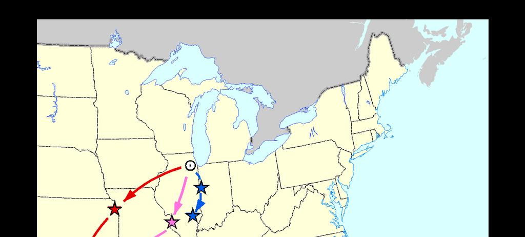
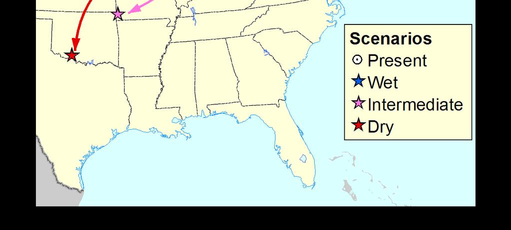
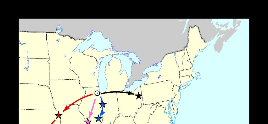
21 What does the future hold for us? How will the climate change? Annual Precipitation 10-year moving average (inches) Illinois River at Peoria-Kingston Mines Precipitation Streamflow ??? Annual Streamflow 10-year moving average (inches)


22 Climate Change Impacts on Water Resources Recent climate change reports have projected the following for the Great Lakes and Midwest: We could see wetter Springs and drier Summers Heavier precipitation events may increase in magnitude and frequency as part of climate change, causing more flooding There could be extended summer periods of precipitation deficit and low flows Thus, the hydrologic cycle could intensify, resulting in more extreme floods and droughts


23 These reports base their conclusions on selected climate scenarios However, There are 23 Global Climate Models considered to be equally credible Over 150 different scenarios from these models The models are consistent with respect to temperature increase, although the projected amount may differ Precipitation is more difficult to model and there is little agreement between models in precipitation trends, much less in determining seasonal trends It s hard to place much confidence in any one characterization of future precipitation when the various models are all across the board.
24
25

 in the Midwest.")
26 Inconsistency between the current Midwest climate and global model predictions Much of Midwest (and eastern USA) shows no 20 th Century warming. Precipitation has increased by 7-10% for much of the Upper Midwest. Some GCM models suggest precipitation increases of this magnitude, but only following years of climate change. This means either that observed patterns in precip and streamflow over the past 30 years are associated almost entirely with climate variability, or that the GCM models are not developed enough to correctly predict climate trends (or perhaps both are true) in the Midwest. The precipitation/streamflow increase of the past 30 years does appear to be within the range of conditions that have been experienced in the previous 150 years (although at the upper end of the range).


27


28 Conclusion In the Illinois River basin, precipitation changes appear to be the driving force behind increases in streamflow and flooding We have only a limited influence on water yields We don t have a reliable projection of future climate conditions and how streamflow and flooding will change. Projected precipitation changes differ considerably depending on climate model. Common perceptions concerning their potential impacts may not hold true for the Midwest and other regions.
Illinois State Water Survey Division
 Illinois State Water Survey Division SURFACE WATER SECTION SWS Contract Report 431 AT THE UNIVERSITY OF ILLINOIS PERTINENT CONSIDERATIONS IN THE DEVELOPMENT OF PROTECTED-STREAMFLOW CRITERIA FOR ILLINOIS
DROUGHT IN ILLINOIS: IMPACTS TO WATER SUPPLY
 DROUGHT IN ILLINOIS: IMPACTS TO WATER SUPPLY 11 th Biennial Governor s Conference on the Management of the Illinois River System October 3, 2007 Peoria Derek Winstanley Chief Fresh water use in Illinois:
Climate Change and Drought Scenarios for Water Supply Planning
 Climate Change and Drought Scenarios for Water Supply Planning Analyses of the sensitivity of water availability (surface water and groundwater) and water demand to climate change and drought will be conducted
Derek Winstanley. MAC/RWSPC Decatur, 2007 June 29, 2007 IDNR/OWR ISWS ISGS
 WATER SUPPLY PLANNING AND MANAGEMENT: CLIMATE VARIABILITY AND CHANGE Derek Winstanley MAC/RWSPC Decatur, 2007 June 29, 2007 IDNR/OWR ISWS ISGS CONTENTS INTRODUCTION DEFINITIONS HISTORICAL CLIMATE FUTURE
Climate Change Impacts on Hydrology of the Western Cascades
 Climate Change Impacts on Hydrology of the Western Cascades Marketa M. Elsner UW Climate Impacts Group Mt Baker - Snoqualmie National Forest Climate Change Workshop April 28, 2011 We care about climate
6. Future Water Demands and Supplies
 As part of the WI&A, agricultural and urban demand scenarios and climate change scenarios have been developed to support analysis of potential future supplies and demands using the BBGM (Davids Engineering
NOAA/NWS Ohio River Forecast Center. Water Resources Committee Climate Trends and Change
 NOAA/NWS Ohio River Forecast Center Water Resources Committee Climate Trends and Change Jim Noel Service Coordination Hydrologist November 27, 2012 Today s Discussion Climate Trends Climate Change vs Variability
Iowa Climate Change Adaptation and Resilience: Applying Climate Data to Plans & Ordinances
 Iowa Climate Change Adaptation and Resilience: Applying Climate Data to Plans & Ordinances Christopher J. Anderson, PhD Assistant Director, Climate Science Program Iowa State University Integrating Hazard
Pre-Event Activities. Blue River. Pre Field Trip Suggestions
 Blue River Have you heard we all live in a watershed? Well, it is true! This total body activity will allow students to demonstrate how water flows in a watershed while exploring how seasonal variations
Uncertainty in hydrologic impacts of climate change: A California case study
 Uncertainty in hydrologic impacts of climate change: A California case study Ed Maurer Civil Engineering Dept. Santa Clara University Photos from USGS Motivating Questions What are potential impacts of
Illinois in Drought. June 19, 2012, Updated June 21, 2012
 June 19,, Updated June 21, Illinois in Drought The ISWS now considers central and southern Illinois to be fully in drought based on several impacts including the early season onset of reservoir drawdown
City of River Falls North Kinnickinnic River Monitoring Project Summary. Report prepared by SEH Inc., for the
 City of River Falls North Kinnickinnic River Monitoring Project 2012 Summary Report prepared by SEH Inc., for the City of River Falls Engineering Department December 2012 Project Introduction: City of
Chehalis Basin Strategy Causes of Extreme Flooding. October 11, 2016 Policy Workshop
 Chehalis Basin Strategy Causes of Extreme Flooding October 11, 2016 Policy Workshop Agenda Hydrology o Precipitation o Flow Climate Change Effects Land Use o Channel straightening and incision o Riparian
Norman Maclean Snowmelt Flow rate Storm flows fs (c flow m a tre S
 Eventually, all things merge into one, and a river runs through it. Norman Maclean Understanding Streamflow ADEQ SW Short Course June 13, 213 Phoenix, AZ Hydrographs Discharge (Q) USGS flow data & plots
Climate Change and Associated Changes to the Water Budget
 CHAPTER 6 Climate Change and Associated Changes to the Water Budget Derek Winstanley 1 & Wayne M. Wendland 2 Illinois State Water Survey Champaign IL 61820 1 Chief, Illinois State Water Survey, 2204 Griffith
SECTION III: WATERSHED TECHNICAL ANALYSIS
 Trout Creek Watershed Stormwater Management Plan SECTION III: WATERSHED TECHNICAL ANALYSIS A. Watershed Modeling An initial step this study of the Trout Creek watershed was the selection of a stormwater
Surface Water Availability in Kane County
 Surface Water Availability in Kane County H. Vernon Knapp, P.E. Illinois State Water Survey Illinois Department of Natural Resources What Factors Most Affect Low Flows and Surface Water Availability for
Climate Change Water Implications for Michigan Communities, Landsystems and Agriculture
 Climate Change Water Implications for Michigan Communities, Landsystems and Agriculture Distinguished Senior Research Specialist Department of Geography Institute of Water Research Climate Change Summary
September 7, Precipitation and Temperature
 September 7, 2012 Precipitation and Temperature Two significant weather events happened since the August 20 drought update. The first event was that August finished with near-normal temperatures and precipitation,
REPORT. Executive Summary
 C C C R 2 01 9 REPORT Executive Summary 2 Canada s Changing Climate Report Executive Summary 3 Authors Elizabeth Bush, Environment and Climate Change Canada Nathan Gillett, Environment and Climate Change
Climate Change and Water Resources: A Primer for Municipal Water Providers
 Climate Change and Water Resources: A Primer for Municipal Water Providers David Yates & Kathleen Miller National Center for Atmospheric Research 1. Introduction A recent collaboration between the AWWA
SECTION IV WATERSHED TECHNICAL ANALYSIS
 A. Watershed Modeling SECTION IV WATERSHED TECHNICAL ANALYSIS An initial step in the preparation of this stormwater management plan was the selection of a stormwater simulation model to be utilized. It
MINING in a CHANGING CLIMATE Vulnerability, Impacts & Adaptation
 MINING in a CHANGING CLIMATE Vulnerability, Impacts & Adaptation Sudbury 2007 Mining and the Environment Tina Neale Adaptation & Impacts Research Division October 22, 2007 Presentation Outline How is the
31. SURFACE WATER HYDROLOGY
 Surface Water Hydrology Cook Inlet Drainages 31. SURFACE WATER HYDROLOGY 31.1 Introduction Chapter 31 of the environmental baseline document presents the findings of the baseline surface water hydrology
Planning for Variability & Uncertainty: Climate Change and
 Planning for Variability & Uncertainty: Climate Change and the UDFCD Urban Drainage System David Bennetts, P.E. Manger of Design, Construction, and Maintenance Programs, UDFCD Dr. Andrew Earles, P.E.,
Global Warming and Water: Some Side-Effects
 Global Warming and Water: Some Side-Effects Tom Pedersen, Executive Director, PICS University of Victoria The Keeling Curve 393 ppm Currently: 393 ppmv ~40% higher than in mid-1800s We can expect a wetter
Based on a presentation by Tim Asplund, Water Resources Specialist Wisconsin Department of Natural Resources
 IS IT CLIMATE CHANGE? Exceptionally low water levels have been observed recently at a large number of lakes in northwestern and north central Wisconsin. As of June 2007, monthly precipitation totals in
1) )CLIMATE CHANGE IN ILLINOIS OS 2) WATER FOR ETHANOL PLANTS
 )CLIMATE CHANGE IN ILLINOIS OS 2) WATER FOR ETHANOL PLANTS") 1) )CLIMATE CHANGE IN ILLINOIS OS 2) WATER FOR ETHANOL PLANTS Champaign West Rotary Club October 17, 2007 Derek Winstanley, D.Phil. Chief Illinois State Water Survey Acknowledgments Ken Kunkel Xin-Zhong
1) )CLIMATE CHANGE IN ILLINOIS OS 2) WATER FOR ETHANOL PLANTS Champaign West Rotary Club October 17, 2007 Derek Winstanley, D.Phil. Chief Illinois State Water Survey Acknowledgments Ken Kunkel Xin-Zhong
Rainfall, Runoff and Peak Flows: Calibration of Hydrologic Design Methods for the Kansas City Area
 Rainfall, Runoff and Peak Flows: Calibration of Hydrologic Design Methods for the Kansas City Area Bruce McEnroe, Bryan Young, Ricardo Gamarra and Ryan Pohl Department of Civil, Environmental, and Architectural
Streamflow of 2013 Water Year Summary
 Streamflow of 23 Water Year Summary U.S. Geological Survey Reston, Virginia January 24 23 Statewide Streamflow Ranks (93 23) Introduction National Overview Regional Patterns Seasonal Characteristics High
From the cornbeltto the north woods; understanding the response of Minnesota. Chris Lenhart Research Assistant Professor BBE Department
 From the cornbeltto the north woods; understanding the response of Minnesota watersheds to climate change Chris Lenhart Research Assistant Professor BBE Department 1. Background Differential response of
1 THE USGS MODULAR MODELING SYSTEM MODEL OF THE UPPER COSUMNES RIVER
 1 THE USGS MODULAR MODELING SYSTEM MODEL OF THE UPPER COSUMNES RIVER 1.1 Introduction The Hydrologic Model of the Upper Cosumnes River Basin (HMCRB) under the USGS Modular Modeling System (MMS) uses a
June 2009: How severe is the current drought in the Hill Country? Raymond M Slade, Jr, PH Certified Professional Hydrologist
 June 2009: How severe is the current drought in the Hill Country? Raymond M Slade, Jr, PH Certified Professional Hydrologist Presentation organization 1. What is drought? 2. Assessment of drought conditions
Variability and Trends in Global Drought. Greg McCabe, USGS, Denver, CO Dave Wolock, USGS, Lawrence, KS
 Variability and Trends in Global Drought Greg McCabe, USGS, Denver, CO Dave Wolock, USGS, Lawrence, KS -2 0-2 0 a. mean global temperature b. Mean global precipitation Global temperature has increased.
16 September Water Management Wilmington District. US Army Corps of Engineers BUILDING STRONG
 FALLS LAKE OPERATIONS UNRBA Board Meeting 16 September 2015 Water Management Wilmington District US Army Corps of Engineers Wilmington District 2 Water Management Mission 24/365 Operate Wilmington District
The Impact of Wetland Drainage on the Hydrology of a Northern Prairie Watershed
 John Pomeroy, Xing Fang, Stacey Dumanski, Kevin Shook, Cherie Westbrook, Xulin Guo, Tom Brown, Adam Minke, Centre for Hydrology, University of Saskatchewan, Saskatoon, Canada The Impact of Wetland Drainage
Rock Creek Floodplain Analysis
 Rock Creek Floodplain Analysis www.co.washington.or.us By Jon Franczyk 1996 Flood, www.co.washington.or.us 1996 Flood, www.co.washington.or.us Project Outline Project Goals Introduction Background Study
4/28/17. Size of Floods - Hydrograph Depicts flood data from gaging station; Hydrographs usually show Q vs. time
 GEOL 118 Final Exam Format similar to exams 1 and 2 Covers Lectures #27 40 (Global Climate Change I - Meteorite Impacts III) #35 Floods - II (Size, Prediction, Urbanization, Mitigation) 8:00, Thursday,
WATER SUPPLIES in EAST CENTRAL ILLINOIS. Champaign YMCA. Derek Winstanley Chief Illinois State Water Survey IDNR UIUC
 WATER SUPPLIES in EAST CENTRAL ILLINOIS November 6, 2007 Champaign YMCA Derek Winstanley Chief Illinois State Water Survey IDNR UIUC Acknowledgments Al Wehrmann, Ctr. for Groundwater Science, ISWS George
Climate Change, Precipitation Trends and Water Quality David S. Liebl
 Climate Change, Precipitation Trends and Water Quality David S. Liebl Wisconsin Lakes Partnership Convention Stevens Point 4/25/14 Map - Kate Barrett Wisconsin Precipitation Trends: 1950-2006 Annual Summer
CHAPTER ONE : INTRODUCTION
 CHAPTER ONE : INTRODUCTION WHAT IS THE HYDROLOGY? The Hydrology means the science of water. It is the science that deals with the occurrence, circulation and distribution of water of the earth and earth
Technical Memorandum No Basis of Comparison
 Pajaro River Watershed Study in association with Technical Memorandum No. 1.2.1 Basis of Comparison Task: Basis of Comparison To: PRWFPA Staff Working Group Prepared by: J. Schaaf Reviewed by: R. Raines
I DON T CARE WHAT THEY SAY, THIS GLOBAL WARMING SCARE IS JUST A BUNCH OF LOONY LEFT- WING ENVIRONMENTAL ANTI-GROWTH HYPE! SO, IS THIS YOUR FIRST
 I DON T CARE WHAT THEY SAY, THIS GLOBAL WARMING SCARE IS JUST A BUNCH OF LOONY LEFT- WING ENVIRONMENTAL ANTI-GROWTH HYPE! SO, IS THIS YOUR FIRST WINTER HERE IN BLAINE? Salt Lake City Tribune August 2015
Comparative study of climate and human impacts on seasonal baseflow in urban and agricultural watersheds
 Click Here for Full Article GEOPHYSICAL RESEARCH LETTERS, VOL. 37,, doi:10.1029/2009gl041879, 2010 Comparative study of climate and human impacts on seasonal baseflow in urban and agricultural watersheds
Climatology, Hydrology, and Simulation of an Emergency Outlet, Devils Lake Basin, North Dakota
 U N I V E R S I T Y O F N O R T H D A K O T A NORTH DAKOTA STATE WATER COMMISSION Climatology, Hydrology, and Simulation of an Emergency Outlet, Devils Lake Basin, North Dakota Abstract Devils Lake is
Forecast Informed Reservoir Operations An Opportunity to Improve the Resiliency of our Water Supply
 Forecast Informed Reservoir Operations An Opportunity to Improve the Resiliency of our Water Supply 2016 International Atmospheric Rivers Conference August 8 2016 Jay Jasperse, Chief Engineer Sonoma County
Climate Change and its Impacts on Water Resources and Extreme Events in Washington State
 February 2015 Climate Change and its Impacts on Water Resources and Extreme Events in Washington State Regional Historical Trends Climate Change Projections 1920-2012 Temperature Trends Squares aren
Colorado River Basin
 Colorado River Basin 16.5 million acre-feet (maf) allocated annually 13 to 14.5 maf of consumptive use annually 60 maf of storage 14.8 maf average annual natural inflow into Lake Powell over past 110 years
Annual Stream Runoff and Climate in Minnesota s River Basins
 ST. ANTHONY FALLS LABORATORY Engineering, Environmental and Geophysical Fluid Dynamics Project Report No. 543 Annual Stream Runoff and Climate in Minnesota s River Basins by Todd R. Vandegrift and Heinz
U.S. Geological Survey Streamflow data in Michigan Using the USGS NWIS database MDOT Bridge Scour Conference October 5, 2017
 U.S. Geological Survey Streamflow data in Michigan Using the USGS NWIS database MDOT Bridge Scour Conference October 5, 2017 Tom Weaver Eastern Hydrologic Data Chief Upper Midwest Water Science Center
Illinois State Water Survey Division
 Illinois State Water Survey Division SURFACE WATER SECTION SWS Contract Report 435 AT THE UNIVERSITY OF ILLINOIS INCREASED DURATIONS OF HIGH FLOWS ALONG THE ILLINOIS AND MISSISSIPPI RIVERS: TRENDS AND
Watershed Response to Water Storage. 8/1/2012 Paul Wymar Scientist Chippewa River Watershed Project
 Watershed Response to Water Storage 8/1/2012 Paul Wymar Scientist Chippewa River Watershed Project Chippewa River Watershed 1.3 Million Acres Largest tributary watershed in the Minnesota River Basin 7
Perspectives of the Saskatchewan River Basin
 Perspectives of the Saskatchewan River Basin Allan Howard, National Agroclimate Information Service, Agriculture Agri-Food Canada, Regina Saskatchewan Presented to the IISD-GWSP Conference on the Water-Energy-Food
Appendix E. Summary of Initial Climate Change Impacts on the Chesapeake Bay Watershed Flows and Loads
 Appendix E. Summary of Initial Climate Change Impacts on the Chesapeake Bay Watershed Flows and Loads The potential effects of climate change have not been explicitly accounted for in the current Chesapeake
Take-Home Message. Remarkable increases in streamflow of the James and Big Sioux Rivers when compared to broader USA
 Take-Home Message Slide 1 Remarkable increases in streamflow of the James and Big Sioux Rivers when compared to broader USA In other watersheds, high flows have been associated with increases in nutrient
Uncertainty in projected impacts of climate change on water
 1928 2000 Uncertainty in projected impacts of climate change on water Ed Maurer Civil Engineering Cambio Climático y Políticas Públicas Centro de Cambio Global Universidad Católica de Chile 23 abril 2009
Hydrologic Design of Impounding Reservoirs in Illinois
 BULLETIN 67 Hydrologic Design of Impounding Reservoirs in Illinois by MICHAEL L. TERSTRIEP, MISGANAW DEMISSIE, DOUGLAS C. NOEL and H. VERNON KNAPP Title: Hydrologic Design of Impounding Reservoirs in Illinois.
Watershed Monitoring for the Lake Decatur Watershed
 Contract Report 602 Watershed Monitoring for the Lake Decatur Watershed by Laura Keefer and Misganaw Demissie Office of Sediment & Wetland Studies Prepared for the City of Decatur July 1996 Illinois State
Distribution Restriction Statement Approved for public release; distribution is unlimited.
 CECW-EH-Y Regulation No. 1110-2-1464 Department of the Army U.S. Army Corps of Engineers Washington, DC 20314-1000 Engineering and Design HYDROLOGIC ANALYSIS OF WATERSHED RUNOFF Distribution Restriction
SOURCE WATER MONITORING
 Monitoring and Protecting Our Water Sources SOURCE WATER MONITORING The Upper Cache la Poudre (UCLP) Watershed Collaborative Monitoring Program was established in 28 between the City of Fort Collins, the
Outline. Regional Overview Mine Study Area. Transportation Corridor Study Area. Streamflow Low Flow Peak Flow Snow Small Pools.
 Environmental Baseline Document Surface Water Hydrology Agency Meetings, January 31 to February 3, 2012 Anchorage, Alaska Jaime Cathcart, P.Eng., Ph.D. Outline 2 Regional Overview Mine Study Area Streamflow
Chapter 3 Stream Discharge
 Chapter 3 Stream Discharge - Introductory Level Volunteer Water Quality Monitoring Training Notebook - What is Discharge (Flow)? Discharge, also called flow, is the amount of water that flows past a given
IPCC WG II Chapter 3 Freshwater Resources and Their Management
 IPCC WG II Chapter 3 Freshwater Resources and Their Management Impacts increasingly harmful & more costly to adapt as global temperature increases May imperil sustainable development goals Semi-arid /
Introduction, HYDROGRAPHS
 HYDROGRAPHS Sequence of lecture Introduction Types of Hydrograph Components of Hydrograph Effective Rainfall Basin Lag or Time Lag Parts of Hydrograph Hydrograph Analysis Factors Affecting Hydrograph Shape
Science supporting the Great Lakes Water Quality Agreement: Groundwater and Climate Change Information Needs and Gaps
 Science supporting the Great Lakes Water Quality Agreement: Groundwater and Climate Change Information Needs and Gaps Latornell Symposium November 19 2015 Great Lakes Water Quality Agreement Purpose: provide
Existing Land Use USACE Fountain Creek Watershed Study Watershed Management Plan, Pueblo
 Existing Land Use USACE Fountain Creek Watershed Study Watershed Management Plan, 2009 Pueblo N Future Land Use (2025) USACE Fountain Creek Watershed Study Watershed Management Plan, 2009 Pueblo N Project
Sobhalatha Kunjikutty
 Sobhalatha Kunjikutty Conservation Ontario _ Climate Change Workshop February 9, 2011 Overview Identify Risk Risk Evaluation Primary & Secondary Impacts Resource Management Implications Adaptive Response
River Processes River action (fluvial)
") River action (fluvial) is probably the single most important geomorphic agent and their influence in geomorphology can hardly be overestimated. 1 To understand the complexity associated with river flow
River action (fluvial) is probably the single most important geomorphic agent and their influence in geomorphology can hardly be overestimated. 1 To understand the complexity associated with river flow
City of Portsmouth Department of Public Works
 City of Portsmouth Department of Public Works August 2, 2018 Portsmouth Water Supply Status Report Overview The following Portsmouth Water Supply Status Report provides the Portsmouth Water customers an
Hydrologic Design of Side-Channel Reservoirs in Illinois
 BULLETIN 66 Hydrologic Design of Side-Channel Reservoirs in Illinois by H. VERNON KNAPP Title: Hydrologic Design of Side-Channel Reservoirs in Illinois. Abstract: This report provides data and methodologies
Forests and Water in the Sierra Nevada. Roger Bales, Sierra Nevada Research Institute, UC Merced
 Forests and Water in the Sierra Nevada Roger Bales, Sierra Nevada Research Institute, UC Merced Some motivating points Water is the highest-value ecosystem service associated with Sierra Nevada conifer
Climate Change in the. Pacific Northwest. Impacts, Choices, and Change
 Climate Change in the UW Climate Impacts Group Pacific Northwest Impacts, Choices, and Change UW Climate Impacts Group http://www.yakima.net/ Philip Mote, Lara Whitely Binder Climate Impacts Group Center
1.0 Introduction. Springfield Supplemental Water Supply Project Project Technical Memorandum: Water Demand Analysis Review
 Springfield, IL Supplemental Water Supply Project Project Name: Springfield Supplemental Water Supply Project SEIS Project Number: 325216041 Date: November 2016 To: Ted Meckes, City of Springfield, CWLP
Technical Memorandum
 Specialists in Agricultural Water Management Serving Stewards of Western Water since 1993 To: From: Technical Memorandum Butte County Department of Water and Resource Conservation Davids Engineering Date:
2. Primary Climate Change Concerns for CAP
 0 1. Introduction The Central Arizona Project (CAP) provides a renewable water supply to central and southern Arizona, where about 80 percent of the population of Arizona resides. This water supply comes
Impact of Climate Change on Water Resources of a Semi-arid Basin- Jordan
 Impact of Climate Change on Water Resources of a Semi-arid Basin- Jordan Prof. Fayez Abdulla Civil Engineering Department Jordan University of Science & Technology Presented at the Water in an Arid Land,
Recent hydro- and pheno-climatic trends & Projections of 21st Century climatic trends for the US
 Recent hydro- and pheno-climatic trends & Projections of 21st Century climatic trends for the US Michael Dettinger US Geological Survey @ Scripps Institution of Oceanography, La Jolla, CA Dan Cayan,, USGS/SIO
Retrospective analysis of hydrologic impacts in the Chesapeake Bay watershed
 Retrospective analysis of hydrologic impacts in the Chesapeake Bay watershed Harsh Beria1,3, Rob Burgholzer2, Venkat Sridhar3 Indian Institute of Technology Kharagpur, India & Summer intern Virginia Department
Prairie Hydrology. If weather variability increases, this could degrade the viability of many aspects of ecosystems, human activities and economy
 Prairie Hydrology John Pomeroy, Xing Fang, Robert Armstrong, Tom Brown, Kevin Shook Centre for Hydrology, University of Saskatchewan, Saskatoon, Canada Climate Change for the Prairies? Highly variable
Climate Change and Adaptation in Irrigated Agriculture - A Case Study of the Yakima River
 Southern Illinois University Carbondale OpenSIUC 2004 Conference Proceedings 7-20-2004 Climate Change and Adaptation in Irrigated Agriculture - A Case Study of the Yakima River Scott Follow this and additional
Central America Climate Change: Implications for the Rio Lempa
 Central America Climate Change: Implications for the Rio Lempa Ed Maurer Civil Engineering Department Santa Clara University Santa Clara, CA, USA Andrew Wood Civil and Environmental Engineering Dept. University
Prepared in Cooperation with: the Houston Galveston Area Council and the Texas Commission on Environmental Quality. By Lee Bodkin and Jeannette Oden
 Surrogate Relationship Development of Suspended Sediment and Total Suspended Solids Utilizing Turbidity and Streamflow Data in the West Fork San Jacinto River, near Conroe, Texas, July 2008 August 2009
Oregon Water Conditions Report December 12, 2016
 Oregon Water Conditions Report December 12, 2016 In the past two weeks, cooler temperatures and an increase in precipitation has been the trend for most of the state. So far this month, precipitation has
Forecast Informed Reservoir Operations An Opportunity to Improve the Resiliency of our Water Supply
 Forecast Informed Reservoir Operations An Opportunity to Improve the Resiliency of our Water Supply Western States Water Council S2S Precipitation Forecasting May 17, 2017 San Diego, California Jay Jasperse,
Hydrologic Pathways: Precipitation, ET, Storage, Runoff & Recharge. Joe Magner, MPCA
 Hydrologic Pathways: Precipitation, ET, Storage, Runoff & Recharge Joe Magner, MPCA Concrete! Sluice gates Channels What was the consequence Loss of 60,000 fishing jobs Initial 20 % loss of lake volume,
Management Strategies for Flood Protection in the Lower Illinois River Phase I: Development of the Lower Illinois River - Pool 26 UNET Model
 Contract Report 2001-10 Management Strategies for Flood Protection in the Lower Illinois River Phase I: Development of the Lower Illinois River - Pool 26 UNET Model by David T. Soong and Yanqing Lian Prepared
YUKON HYDROLOGIC RESPONSE WHAT WE KNOW AND WHAT WE THINK WE KNOW
 YUKON HYDROLOGIC RESPONSE WHAT WE KNOW AND WHAT WE THINK WE KNOW J Richard Janowicz Water Resources Branch Yukon Department of Environment Whitehorse, Yukon OVERVIEW Climate Change / Climate Warming Summarize
Glades Reservoir Draft Environmental Impact Statement
 Glades Reservoir Draft Environmental Impact Statement Chapter 4 Environmental Consequences October 2015 4 ENVIRONMENTAL CONSEQUENCES 4.1 INTRODUCTION 4-1 4.1.1 Types and Definitions of Impacts 4-1 4.1.2
Water Budgets. 1. Recap of Groundwater What is required for a water budget? 3. How will water budgets be used in GSPs? 4. Factors to consider
 Water Budgets 1 Water Budgets 1. Recap of Groundwater 1.0 2. What is required for a water budget? 3. How will water budgets be used in GSPs? 4. Factors to consider 5. Practice! 2 Conceptual Water Budget
WATER AVAILABILITY AND DROUGHT CONDITIONS REPORT Issued on April 27, 2010
 WATER AVAILABILITY AND DROUGHT CONDITIONS REPORT Issued on April 27, 2010 Synopsis/Overview Outlook Precipitation has been below across Manitoba during the last three months. Except for the Red, Souris
Climate Change & Impact on Water Resources in the San Joaquin Valley
 Climate Change & Impact on Water Resources in the San Joaquin Valley Roger Bales, UC Merced NASA-MODIS satellite image Since 1895, annual average air temperatures in California have increased by about
CLIMATE CHANGE SCENARIOS FOR YUKON FLATS NATIONAL WILDLIFE REFUGE, ALASKA
 CLIMATE CHANGE SCENARIOS FOR YUKON FLATS NATIONAL WILDLIFE REFUGE, ALASKA Anna Springsteen University of Alaska and The Wilderness Society Wendy Loya The Wilderness Society Climate Change in the Northern
Climate Trends in the Corn Belt
 Climate Trends in the Corn Belt Eugene S. Takle Professor Department of Agronomy Department of Geological and Atmospheric Science Director, Climate Science Program Iowa State University Ames, IA 50011
Hydraulic Analyses for LaGrange Pool of the Illinois River: A Component of the Restoration of Large River Ecosystems Project
 Contract Report 651 Hydraulic Analyses for LaGrange Pool of the Illinois River: A Component of the Restoration of Large River Ecosystems Project by Renjie Xia and Misganaw Demissie August 1999 Illinois
Past Peak Water in the Southwest
 Past Peak Water in the Southwest Martin Hoerling NOAA Earth System Research Laboratory and Jon Eischeid University of Colorado CIRES Nobody relishes being past peak anything. Whether it s the prime of
Background Information on the. Peace River Basin
 Background Information on the Peace River Basin Resource Conservation & Development Department August 24 Background Physiography The Peace River drainage basin occupies large parts of Polk, Hardee, DeSoto,
Riparian Restoration on California's Coast November 3, Reach scale
 Research and Adaptive Management Research approaches in stream corridor assessment and restoration Integral to all components Recognition of uncertainty Commitment to monitor and learn Willingness to adjust
ANALYZING THE EFFECTS OF THE SALUDA DAM ON THE SURFACE- WATER HYDROLOGY OF THE CONGAREE NATIONAL PARK FLOODPLAIN, SOUTH CAROLINA
 ANALYZING THE EFFECTS OF THE SALUDA DAM ON THE SURFACE- WATER HYDROLOGY OF THE CONGAREE NATIONAL PARK FLOODPLAIN, SOUTH CAROLINA Paul A. Conrads 1, Toby D. Feaster 2, and Larry G. Harrelson 3 AUTHORS:
5/25/2017. Overview. Flood Risk Study Components HYDROLOGIC MODEL (HEC-HMS) CALIBRATION FOR FLOOD RISK STUDIES. Hydraulics. Outcome or Impacts
 CALIBRATION FOR FLOOD RISK STUDIES. Hydraulics. Outcome or Impacts") HYDROLOGIC MODEL (HEC-HMS) CALIBRATION FOR FLOOD RISK STUDIES C. Landon Erickson, P.E.,CFM Water Resources Engineer USACE, Fort Worth District April 27 th, 2017 US Army Corps of Engineers Overview Flood
HYDROLOGIC MODEL (HEC-HMS) CALIBRATION FOR FLOOD RISK STUDIES C. Landon Erickson, P.E.,CFM Water Resources Engineer USACE, Fort Worth District April 27 th, 2017 US Army Corps of Engineers Overview Flood
The Changing Gila River: Past, Present and Future
 The Changing Gila River: Past, Present and Future David S. Gutzler University of New Mexico gutzler@unm.edu à How is the hydrograph on the upper Gila projected to change as climate warms up? Catron Co