WHITNEY ROAD 10% CORRIDOR PLAN. Open House Meeting #1 November 8, 2017
|
|
|
- Naomi Henderson
- 6 years ago
- Views:
Transcription


1 WHITNEY ROAD 10% CORRIDOR PLAN Open House Meeting #1 November 8, 2017


2 AGENDA Introductions Project Overview Limits Purpose and Goals Overall Study Process What to expect (i.e. Schedule)? Identifying the Issues Possible Concept Ideas? Adjourn to Workshop Area 2


3 PROJECT OVERVIEW History Limits Study not Construction Northern Limit Storey Blvd./ Beckle Road Southern Limit U.S. 30 Objective Goals Create a comprehensive plan which strives to optimize safety, growth, and fiscal responsibility Understand the community and neighborhood vision for the roadway Project Study Area Improve roadway and intersection safety and function Address drainage and snow drifting

 Social Media Blog Facebook, Twitter Email Notifications Alternative Development Alternative Analysis")
4 OVERALL STUDY PROCESS Existing Conditions Topography Utilities Drainage Environmental Historical Accurate Traffic Data Collection Accurate Traffic Projections Regulatory Design Policies UDC Laramie County Land Use Regulations Planning/ Data Collection Steering Committee Jurisdictional Meetings MPO Committees Public Involvement Public Open House(s) Social Media Blog Facebook, Twitter Notifications Alternative Development Alternative Analysis Design 4
5 WHAT TO EXPECT? PROJECT MILESTONES MILESTONE DATES Notice to Proceed March 1, 2017 Initial Kickoff Meeting MPO March 22, 2017 Traffic Counts April 4, 2017 Steering Committee Meetings May 9, 2017; December, 2017 Open House/ Public Meeting #1 November 8, 2017 Draft Plan November December, 2017 Neighborhood Meeting #2 January, 2018 Submit DRAFT Plan to MPO January, 2018 Presentation to the Governing Body March,

6 IDENTIFYING THE ISSUES? Utilities Blackhills Energy High West Energy Suncor Energy Plains All American Pipeline System, LLC Qwest/ Century BOPU Water 6


7 IDENTIFYING THE ISSUES? Blackhills Energy Underground natural gas feeding rural subdivisions High West Energy Overhead Electric 7


8 IDENTIFYING THE ISSUES? BOPU Underground water and sewer mains Fire Hydrant Century Link Underground communication lines 8


9 IDENTIFYING THE ISSUES? Petroleum Pipelines Suncor Energy Steel Crude Line 2 to 5 deep (East Side) Plains All American Pipeline System, LLC 16 Steel Crude 4-3 to 14-5 (West Side) 9

10 IDENTIFYING THE ISSUES? Pavement Condition Narrow width Visibility of Approach to main roadway 10

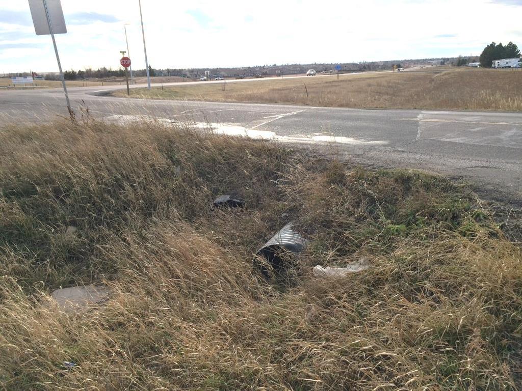
11 IDENTIFYING THE ISSUES? Drainage 11


12 Beckle Drive Buttercup Drive Chickadee Drive Foxglove Drive Dell Range Blvd. Whitney Road 10% Corridor Plan U.S. Highway 30 IDENTIFYING THE ISSUES? Steep Grades 5% ADA Profile 26 Cut Existing Ground Existing Ground 12


13 CONSTRAINTS AND OPPORTUNITIES Blowing and Drifting Snow Snow removal costs Accidents Property damage Pavement maintenance 13
 Dell Range Blvd. Proximity of residential driveways to intersection Future development access control Greenmeadow Drive 80 Right-of-way 14")
14 Whitney Road Whitney Road 10% Corridor Plan Woodhouse Drive U.S. Highway 30 IDENTIFYING THE ISSUES? 90 Right-of-way (i.e. 40 N & 50 S) 80 Right-of-way 100 Right-of-way (i.e. 60 N & 40 S) Dell Range Blvd. Proximity of residential driveways to intersection Future development access control Greenmeadow Drive 80 Right-of-way 14
 15")
15 Whitney Road Whitney Road 10% Corridor Plan IDENTIFYING THE ISSUES? Greenmeadow Drive 80 Right-of-way Proximity of commercial and mobile home access driveways to intersection Proximity and Angle U.S. 30 Service Road 10 Road Reservation Jolly Roger RV and Mobile Home Park Access Proximity Intersection Angle of U.S. 30 Intersection at Whitney Road Future Commercial Access Proximity to Intersection 300 Right-of-way 90 Right-of-way (i.e. 40 W & 50 E) 15
16 IDENTIFYING THE ISSUES? Intersection Crash Data (January, 2014 to September, 2017) 16
17 POSSIBLE CONCEPT IDEAS Rural Typical Section 2 - Lane 17
18 POSSIBLE CONCEPT IDEAS Rural Typical Section 3 - Lane 18

19 POSSIBLE CONCEPT IDEAS Urban Typical Section 3 - Lane 19


20 POSSIBLE CONCEPTS Standard 4 leg Intersection Plain Marked w/ Rightturn Lanes Marked w/ Left-turn Lanes Channelized Islands Roundabouts 1 Lane 2 Lane 20
21 WORK SHOP STATION AREAS Two (2) identical Work Station Tables Overall corridor aerial layout Existing and conceptual street sections Existing Traffic Conditions layout Comment card area Refreshment area


22 ADJOURN TO THE WORKSHOP AREAS Beckle Road Project Study Area Table 1 (Dell Range to Beckle Road/ Storey) Dell Range Blvd. Table 2 (Dell Range to U.S. 30) U.S. 30
Chapter 2 Transportation Element Goals, Objectives and Policies
 Chapter 2 Transportation Element Goals, Objectives and Policies City of Belleview Comprehensive Plan Adopted by Ord 2016-10 on July 5, 2016 GOALS, OBJECTIVES AND POLICIES Goal 2 Transportation...1 Objective
December 10, Steering Committee Meeting #7. 1. Traffic Models & Discussion Abelin Traffic. 2. January 8 Public Meeting. 3.
 December 10, 2018 1 Steering Committee Meeting #7 1. Traffic Models & Discussion Abelin Traffic 2. January 8 Public Meeting 3. Online Survey Hwy 93 Vehicle Crash Summary 2008-2017 2 Location on Highway
ROADWAY DESIGN AND CONSTRUCTION STANDARDS
 ROADWAY DESIGN AND CONSTRUCTION STANDARDS Adopted: 1990 Amended: 1994 2003 2011 2013 ROADWAY DESIGN AND CONSTRUCTION STANDARDS ORIGINALLY ADOPTED IN 1990 Resolution No. R-990-046 OFFICIALLY AMENDED IN
ASSIGNMENT OF ACCESS MANAGEMENT CLASSIFICATIONS TO THE STATE HIGHWAY SYSTEM
 Approved: Effective: December 10, 2001 Office: Systems Planning Topic No.: 525-030-155-e Thomas F. Barry, Jr., P.E. Secretary ASSIGNMENT OF ACCESS MANAGEMENT CLASSIFICATIONS TO THE STATE HIGHWAY SYSTEM
APPENDIX D ACCESS MANAGEMENT GUIDELINES
 APPENDIX D ACCESS MANAGEMENT GUIDELINES Access management has become an important tool in transportation planning. Access management guidelines are intended to preserve the integrity of roadways by balancing
TRANSPORTATION RELATIONSHIP TO OTHER ELEMENTS OF THE PLAN AND COUNTY REGULATIONS VISION FOR TRANSPORTATION PLANNING ROAD NETWORK SECTION 7
 TRANSPORTATION Like many growing western counties, Douglas County focuses on one of the most integral elements in land-use planning: transportation. The primary purpose of a transportation network is to
CITY OF DRAPER TRAFFIC IMPACT STUDY DESIGN GUIDELINES
 CITY OF DRAPER TRAFFIC IMPACT STUDY DESIGN GUIDELINES June 1, 2012 Draper City Traffic Impact Study Guidelines Table of Contents Introduction... 1 Traffic Impact Classification Levels... 1 Analysis Approach
TABLE SUMMARY OF POTENTIAL CONFLICTS WITH MAJOR UTILITIES DUS ACCESS TO 162 ND AVENUE AREA
 3.13 UTILITIES 3.13.1 Introduction to Analysis Impacts to existing utilities by transportation projects have the potential to adversely affect the cost and schedule of a project as well as neighboring
Scope of Work. Project Approach and Understanding. Task 1: Study Initiation and Administration
 Scope of Work Route 116/Hinesburg Growth Center Corridor Study Town of Hinesburg and CCRPC Project Approach and Understanding Route 116 through Hinesburg had seen substantial changes in the past 15 years,
Application of Road Safety Audits to Urban Streets
 Application of Road Safety Audits to Urban Streets ABSTRACT EUGENE M. WILSON Professor Civil Engineering Dept. University of Wyoming Laramie, WY 82071 MARTIN E. LIPINSKI Professor Department of Civil Engineering
US-101 CORRIDOR ADVISOR S UPDATE 19 MARCH 2015
 US-101 CORRIDOR ADVISOR S UPDATE 19 MARCH 2015 1 DELIVERY RECOMMENDATION GOALS Project Readiness: Enhance Funding pursuits Corridor Related Projects Coordination Develop Information to: Resolve Questions
Comprehensive Transportation Study for Glencoe, MN
 Comprehensive Transportation Study for Glencoe, MN Introduction and Project Information Introduction There have been a number of planning and preliminary engineering studies completed in the Glencoe area
PROPOSED AMENDMENT OF THE I 76 INTEGRATED CORRIDOR MANAGEMENT PROJECT TO THE CONNECTIONS 2040 PLAN FOR GREATER PHILADELPHIA
 PROPOSED AMENDMENT OF THE I 76 INTEGRATED CORRIDOR MANAGEMENT PROJECT TO THE CONNECTIONS 2040 PLAN FOR GREATER PHILADELPHIA Background and Project Description In July 2013, the Delaware Valley Regional
Arterial Connector Study Adoption Considerations
 Arterial Connector Study Adoption Considerations 1. The Problem/Opportunity. Dakota County, MnDOT and the cities of Inver Grove Heights and Rosemount have conducted this study because Dakota County is
ADA Training Design Case Studies MnDOT
 ADA Training Design Case Studies 2018 MnDOT 2 ADA Design Case Studies Overview TH 61 (Mounds Blvd) Mill & Overlay Lesson: Steep Slopes and Construction Limits Snelling Avenue Mill & Overlay Lesson: Strategies
MEMORANDUM. Date: July 14, 2006 Project #: To: US 97 & US 20 Refinement Plan Steering Committee
 MEMORANDUM Date: July 14, 2006 Project #: 6389 To: US 97 & US 20 Refinement Plan Steering Committee From: Sonia Hennum, P.E., Andrew Cibor, E.I.T., & Julia Kuhn, P.E. Project: US 97 & US 20 Refinement
Driveway Permits Following Guidelines PLANNING REQUIREMENTS CAPABILITIES ASSISTANCE ACCESS MANAGEMENT LAND USE CONTROLS ECONOMIC DEVELOPMENT
 CHAPTER 5 Access Management PASSIVE Driveway Permits Following Guidelines Comprehensive Access Management PLANNING REQUIREMENTS Access Restrictions CAPABILITIES Process ASSISTANCE ACCESS MANAGEMENT LAND
Appendix S10 - Airport Business Zone Structure Plan
 S10.1 S10.1.1 S10.1.2 General The Airport Business Zone Structure Plan covers an area of some 157ha surrounding the airport operational area. It contains some existing industrial and service activities
PWC Neighborhood Services Conference. February 20, 2016 Aleksandra Tuliszka Assistant Transportation and Land Use Director
 PWC Neighborhood Services Conference February 20, 2016 Aleksandra Tuliszka Assistant Transportation and Land Use Director www.virginiadot.org Overview: VDOT s primary Function The Virginia Department of
US 14 EIS (New Ulm to N. Mankato) Interchange and Intersection Type Comparison
 Interchange and Intersection Type Comparison") T E C H N I C A L M E M O R A N D U M US 14 EIS (New Ulm to N. Mankato) Interchange and Intersection Type Comparison PREPARED FOR: Mn/DOT District 7 PREPARED BY: CH2M HILL DATE: March 27, 2007 This technical
T E C H N I C A L M E M O R A N D U M US 14 EIS (New Ulm to N. Mankato) Interchange and Intersection Type Comparison PREPARED FOR: Mn/DOT District 7 PREPARED BY: CH2M HILL DATE: March 27, 2007 This technical
DEVELOPMENT REPORT UNION PACIFIC PROPERTY SAN ANTONO INTERMODAL YARD AREA
 DEVELOPMENT REPORT UNION PACIFIC PROPERTY SAN ANTONO INTERMODAL YARD AREA This report was prepared to present development information (Utility availability, Development Regulations, Flood Plain information,
Agenda Item B.9 CONSENT CALENDAR Meeting Date: May 19, 2015
 CPMS Agenda Item B.9 CONSENT CALENDAR Meeting Date: May 19, 2015 TO: FROM: Mayor and Councilmembers Rosemarie Gaglione, Public Works Director CONTACT: James Winslow, Sr. Project Manager SUBJECT: Amendment
DRAFT. SR-60 7 th Avenue Intersection Control Evaluation (ICE) I-605 Corridor Improvement Project (CIP) I-605/SR-60 EA# 3101U0
 I-605 Corridor Improvement Project (CIP) I-605/SR-60 EA# 3101U0") SR-60 7 th Avenue Intersection Control Evaluation (ICE) I-605/SR-60 EA# 3101U0 October 9, 2017 Contents 1 Purpose of ICE Memo... 1 2 Background... 1 3 Existing Interchange Deficiencies... 1 4 Context Sensitive
SR-60 7 th Avenue Intersection Control Evaluation (ICE) I-605/SR-60 EA# 3101U0 October 9, 2017 Contents 1 Purpose of ICE Memo... 1 2 Background... 1 3 Existing Interchange Deficiencies... 1 4 Context Sensitive
Statewide Roundabout Guidance
 Statewide Roundabout Guidance Chris Tiesler, PE Associate Engineer Michael Clements, PE Signal & Arterial System Manager Agenda Background Three Tools Screening Tool Spreadsheet Tool Design Guidance Primer
An Introduction to the. Safety Manual
 An Introduction to the Highway Safety Manual An Introduction to the HIGHWAY SAFETY MANUAL Table of Contents Section 1: HSM Overview... 1 What is the Highway Safety Manual?... 1 How is the HSM Applied?...
Application Number: SP Project Name: Lidl Grocery Store, Major Site Plan
 Town of Clayton Planning Department 111 E. Second Street, Clayton, NC 27520 P.O. Box 879, Clayton, NC 27528 Phone: 919-553-5002 Planning Board June 26, 2017 STAFF REPORT Application Number: 2017-76-SP
Clair-Maltby. Mobility Study Work Plan. Prepared by: BA Group. Transform. Connect. Community.
 Clair-Maltby Transform. Connect. Community. Mobility Study Work Plan Prepared by: BA Group June 2017 Memorandum TO: Clair-Maltby SP Working Team FROM: Paul M. Sarjeant, M.A.Sc, P.Eng. PROJECT: 5976-06
AGENCY MEETING. I-10E Planning & Environmental Linkages Meeting #1 TxDOT Houston District
 AGENCY MEETING I-10E Planning & Environmental Linkages Meeting #1 TxDOT Houston District January 25, 2018 WELCOME TxDOT Project Manager: Grant Chim, P.E. Agenda 1 Introductions / Purpose of Meeting 2 What
Mobility and System Reliability Goal
 Mobility and System Reliability Goal Provide surface transportation infrastructure and services that will advance the efficient and reliable movement of people and goods throughout the state. Background:
ARC Freight Advisory Task Force Meeting. SOUTH FULTON COMMUNITY IMPROVEMENT DISTRICT Multi-Modal Study
 ARC Freight Advisory Task Force Meeting SOUTH FULTON COMMUNITY IMPROVEMENT DISTRICT Multi-Modal Study March 1, 2018 Outline Study Overview Scope of Work Key Investment Needs Draft Investment Recommendations
TH 25 Bituminous Mill, Full Depth Reclamation and Overlay SP &
 TH 25 Bituminous Mill, Full Depth Reclamation and Overlay SP 4910-29 & 0504-14 Contract No. 1002252 Project Overview is in need of professional and technical assistance to provide detail design for State
Final Air Quality Report
 Florida Department of Transportation - District VII County Line Road (C.R. 578) Project Development and Environment Study From U.S. 19 (S.R. 55) to U.S. 41 (S.R. 45) Work Program Item Segment Number: 257298
Chapter 1. General Design Information. Section 1.02 Structure Selection and Geometry. Introduction
 Chapter 1 Bridge Design Manual General Design Information Section 1.02 Selection and Geometry Introduction Selection or Rehabilitation Report This section of the design manual provides guidance on the
HALIFAX REGIONAL MUNICIPALITY MUNICIPAL DESIGN GUIDELINES
 HALIFAX REGIONAL MUNICIPALITY MUNICIPAL DESIGN GUIDELINES 2013 PART B STANDARD DETAILS Municipal Design Guidelines Contents PART B: STANDARD DETAILS Municipal Roads/Streets HRM 1 HRM 2 HRM 3 HRM 4 HRM
Process to Identify High Priority Corridors for Access Management Near Large Urban Areas in Iowa
 Process to Identify High Priority Corridors for Access Management Near Large Urban Areas in Iowa David Plazak and Reg Souleyrette Center for Transportation Research and Education Iowa State University
Exhibit A Scope of Work. 0.0 Separation of work Types and Cost Estimate
 0.0 Separation of work Types and Cost Estimate Exhibit A Scope of Work 0.1 Prepare scope of work and cost estimate for MnDOT efforts relating to all items numbered less than 20.0. 0.2 Prepare scope of
US-101 CORRIDOR ADVISOR S UPDATE
 US-101 CORRIDOR ADVISOR S UPDATE MONTECITO ASSOCIATION BOARD OF DIRECTORS 12 MAY 2015 1 SCOPE OF SERVICES Identify & evaluate innovative project delivery strategies: Avoid & minimize delays / expedite
TRAFFIC STUDY GUIDELINES
 TRAFFIC STUDY GUIDELINES December 2013 The scope of the traffic impact analysis (TIA) should follow these guidelines and the requirements of VMC 11.80.130 and VMC 11.70, transportation concurrency (attached
Cleveland Opportunity Corridor Project Section 3. Subcontractor Informational Meeting August 12, 2016
 Cleveland Opportunity Corridor Project Section 3 Subcontractor Informational Meeting August 12, 2016 Agenda Welcome and Opening Remarks Project Overview Prequalifications & Work Types Procurement Overview
Proposed Comprehensive Update to the State of Rhode Island s Congestion Management Process
 Proposed Comprehensive Update to the State of Rhode Island s Statewide Planning Program January 2018 Summary Outline of of Action Steps 1. Develop Objectives for Congestion Management What is the desired
Dale Mabry Pedestrian Overpass Technical Feasibility Analysis. March 2017
 Dale Mabry Pedestrian Overpass Technical Feasibility Analysis March 2017 Overview Two Part Study: 1. Feasibility of Alternatives for a Pedestrian Overpass Across Dale Mabry Hwy Near I 275 2. Walk/Bike
NORTH SANTA MONICA BAY COASTAL WATERSHEDS ENHANCED WATERSHED MANAGEMENT PROGRAM
 NORTH SANTA MONICA BAY COASTAL WATERSHEDS ENHANCED WATERSHED MANAGEMENT PROGRAM Public Workshop #2 King Gillette Ranch, Calabasas November 13, 2014 NSMBCW WATERSHED ASBS = Area of Special Biological Significance
MOBILITY AND ALTERNATIVES ANALYSIS
 6 MOBILITY AND ALTERNATIVES ANALYSIS BACK OF SECTION DIVIDER 6.0 Mobility and Alternatives Analysis Travel demand analysis provides a framework for the identification of transportation facilities and services
Scope of Work. Land Use, Transportation, and Resilience: Scenario Planning Study East Tangipahoa Area State Project No. H RPC Task: ETangi
 Scope of Work Land Use, Transportation, and Resilience: Scenario Planning Study East Tangipahoa Area State Project No. H.013576 RPC Task: ETangi Project Description The Regional Planning Commission is
Palm Beach MPO Board Meeting December 7, 2015
 Palm Beach MPO Board Meeting December 7, 2015 Overview 1 Background and History 3 Public and Agency Engagement Strategy 2 Overview of Scope and Schedule for the Study 4 Next Steps 2 1 Background and History
For Public Input Period
 20142018 CAPITAL IMPROVEMENT PLAN ( Thousands) CITY OF HOUSTON STREET & TRAFFIC CONTROL Project: Kingwood Drive N100011 Loop 494 to Woodland Hills Project Description Project provides for the ROW acquisition,
Engineering Assessment Process: Keys to a Solid Engineer s Report
 Engineering Assessment Process: Keys to a Solid Engineer s Report 89th Annual Purdue Road School March 26, 2003 Brad Steckler, P.E. Brad L. Steckler, P.E. Manager of Engineering Assessment Indiana Department
Geometric Design: Past, Present, and Future
 A2A02: Committee on Geometric Design Chairman: Daniel B. Fambro Geometric Design: Past, Present, and Future DANIEL B. FAMBRO, Texas A&M University JOHN C. COLLINGS, Delcan Corporation ROBERT DELLA VEDOVA,
Rehabilitation of West Main Street Culvert and Shirley Street Bridge. Town of Ayer. November 22, 2016
 Rehabilitation of West Main Street Culvert and Shirley Street Bridge Town of Ayer November 22, 2016 Agenda Outline Introductions Project Goals and Objectives Existing Conditions Review Design Considerations
Constructability Guidelines
 Constructability Guidelines The Constructability Guidelines offer a list of items that should be considered by Constructability function personnel during the Concept Development Phase through the Final
Nashville Regional Freight & Goods Movement Study Phase III
 Mayor Karl Dean, Chairman Nashville Regional Freight & Goods Movement Study Phase III Freight Advisory Committee Meeting #2 June 3 rd, 2015 Agenda Update on Freight Vision/Regional Truck Route Network
Geni Bahar, P.E. Describe key concepts and applications
 FUNDAMENTALS OF SAFETY Geni Bahar, P.E. Slide 1 Outline Describe key concepts and applications Collision Severity Safety Performance Functions Prediction Models Observed, Predicted and Expected Crash Frequency
SELF STORAGE LAND FOR SALE
 An opportunity to acquire 5 Acres gross of C1 zoned land on Amethyst Road. This site is ideal for a Self Storage or Neighborhood Retail Center that is in the path of growth making it strategic asset that
GUIDE FOR THE PREPARATION OF TRAFFIC IMPACT STUDIES
 GUIDE FOR THE PREPARATION OF TRAFFIC IMPACT STUDIES Adopted by Town Council on November 25, 2008 Prepared By: HNTB Engineering Department Planning Department TABLE OF CONTENTS I. INTRODUCTION... 1 II.
Chapter 3 Dispersion BMPs
 Chapter 3 Dispersion BMPs 3.1 BMP L611 Concentrated Flow Dispersion 3.1.1 Purpose and Definition Dispersion of concentrated flows from driveways or other pavement through a vegetated pervious area attenuates
Arterial Management Plan Methodology
 Arterial Management Plan Methodology August 21, 2015 INTRODUCTION The Commonwealth Transportation Board (CTB) approved a process for developing Corridor Master Plans on the Corridors of Statewide Significance
THE HIGHWAY SAFETY MANUAL
 THE HIGHWAY SAFETY MANUAL AASHTO Subcommittee on Design June 16, 2006 1 Overview of Presentation Purpose of the Highway Safety Manual Highway Safety Manual Contents Challenges Ahead 2 3 Is this road safe
Attachment No. 1 Council Report Attachment
 Attachment No. 1 Council Report Attachment 19T-03E01 Part Lots 16 to 19, Concession 2, Town of East Gwillimbury Re: Draft Plan of Subdivision prepared by KLM Planning Partners Inc. Project No. P-466, dated
TRANSPORTATION IMPACT STUDIES
 January 28, 2009 POLICIES AND PROCEDURES FOR TRANSPORTATION IMPACT STUDIES Related to Highway Occupancy Permits Pennsylvania Department of Transportation Bureau of Highway Safety and Traffic Engineering
WELCOME TO THE PUBLIC INFORMATION OPEN HOUSE!
 WELCOME TO THE PUBLIC INFORMATION OPEN HOUSE! The purpose of today s meeting is to: Introduce the Highway 41 Corridor Improvements project, discuss the environmental review process, and present next steps.
To Market, To Market. Discussion Contents. Part 1: Land Use & Infrastructure
 To Market, To Market Discussion Contents Part 1: Land Use & Infrastructure Internal Capture & Pass By Traffic Urban Calculations Rural Realities Case Study 1: Rural Pass-By Community Capture Case Study
NJDOT: Asset Management Strategies and Tools
 NEW JERSEY DEPARTMENT OF TRANSPORTATION NJDOT: Asset Management Strategies and Tools Wednesday, October 1, 2014 Afternoon Session (1:45pm 2:30pm) Presenters Michael Castaldo New Jersey Department Of Transportation
RIDOT S Statewide Roadway and Asset Data Collection Project
 RIDOT S Statewide Roadway and Asset Data Collection Project ESRI User Conference 2017 Rafiq Basaria, DTS; Daniel Behnke DTS, Shane White, RIDOT Accent image here Primary Image here What is MIRE? Recommended
FOR INTERSTATE 81 AND ROUTE 37 INTERCHANGE FREDERICK COUNTY, VIRGINIA MILEPOST 310
 INTERCHANGE MODIFICATION REPORT FOR INTERSTATE 81 AND ROUTE 37 INTERCHANGE FREDERICK COUNTY, VIRGINIA MILEPOST 310 PREPARED BY: VIRGINIA DEPARTMENT OF TRANSPORTATION STAUNTON DISTRICT DECEMBER 13, 2006
DAKOTA COUNTY PHYSICAL DEVELOPMENT COMMITTEE OF THE WHOLE
 DAKOTA COUNTY PHYSICAL DEVELOPMENT COMMITTEE OF THE WHOLE November 7, 2017 Agenda Study Purpose Study Process Resolution Next Steps MAPO Transportation Study Purpose Plan The Need For The Study: Bridge
PIMA COUNTY REGIONAL ACCESS MANAGEMENT PLAN (RAMP) LOCAL AND NON-LOCAL ACCESS MANAGEMENT PROGRAMS DELIVERABLE 1B
 LOCAL AND NON-LOCAL ACCESS MANAGEMENT PROGRAMS DELIVERABLE 1B") PIMA COUNTY REGIONAL ACCESS MANAGEMENT PLAN (RAMP) LOCAL AND NON-LOCAL ACCESS MANAGEMENT PROGRAMS DELIVERABLE 1B April 2008 Prepared by: Curtis Lueck & Associates 5460 West Four Barrel Court Tucson, AZ
PIMA COUNTY REGIONAL ACCESS MANAGEMENT PLAN (RAMP) LOCAL AND NON-LOCAL ACCESS MANAGEMENT PROGRAMS DELIVERABLE 1B April 2008 Prepared by: Curtis Lueck & Associates 5460 West Four Barrel Court Tucson, AZ
1RUWKZHVW#:LFKLWD 0DMRU#,QYHVWPHQW#6WXG\
 1RUWKZHVW#:LFKLWD 0DMRU#,QYHVWPHQW#6WXG\ Executive Summary 3UHSDUHGýIRUã 3UHSDUHGýE\ã.DQVDVý'HSDUWPHQWýRI 7UDQVSRUWDWLRQ,QýDVVRFLDWLRQýZLWKã (DUWKý7HFKý,QFï EXECUTIVE SUMMARY Introduction This Northwest
Public Meeting. US Highways 18 & 281 and SD Highway 50 From Douglas County Line to SD46 Charles Mix County
 Public Meeting US Highways 18 & 281 and SD Highway 50 From Douglas County Line to SD46 Charles Mix County Cary Cleland Road Design Engineering Supervisor January 17, 2017 Project Limits US18/US281 US281
ROAD SAFETY AUDIT CONFEDERATED SALISH & KOOTENAI TRIBES
 2017 NW TTAP & BIA Symposium Spokane, WA ROAD SAFETY AUDIT CONFEDERATED SALISH & KOOTENAI TRIBES Presenter: Gabriel Johnson, P.E. Natural Resources Department Roads Program Manager The Confederated Salish
CHAPTER 5. City of Greensburg Comprehensive Plan. Introduction. Transportation Goals & Objectives
 CHAPTER 5 TRANSPORTATION Introduction The transportation system forms the backbone of the community. I-74 provides the community with connections to larger metropolitan areas such as Indianapolis and Cincinnati.
LAS VEGAS STREET RAILROAD CROSSING RR/PUC CONNECTION AND PRELIMINARY DESIGN
 LAS VEGAS STREET RAILROAD CROSSING RR/PUC CONNECTION AND PRELIMINARY DESIGN Prepared for: City of Colorado Springs Prepared by: Felsburg Holt & Ullevig 508 South Tejon Street Colorado Springs, CO 80903
H Transportation Facility Planning, MD 214 from MD 468 to Eastern Terminus Public Meeting Existing Conditions 7/17/18 Q&A
 Q1: What are the currently planned developments and anticipated impacts? A1: Projections were presented at the meeting and are discussed in the report (available on project website). Model provided by
MEETING SUMMARY FOR APRIL 13, 2017
 SARASOTA/MANATEE METROPOLITAN PLANNING ORGANIZATION Performance Measures/Project Prioritization Process Ad Hoc Committee 7632 15 th Street East Sarasota, Florida 34243 3:00-5:00 PM MEETING SUMMARY FOR
4.10 LAND USE ENVIRONMENTAL SETTING
 4.10 LAND USE 4.10.1 ENVIRONMENTAL SETTING The proposed Project consists of construction and operation of two 8-inch crude oil pipelines (within one trench) and equipment for storage and pumping from the
This is a digital document from the collections of the Wyoming Water Resources Data System (WRDS) Library.
 Library.") This is a digital document from the collections of the Wyoming Water Resources Data System (WRDS) Library. For additional information about this document and the document conversion process, please contact
This is a digital document from the collections of the Wyoming Water Resources Data System (WRDS) Library. For additional information about this document and the document conversion process, please contact
2. Guiding Principles, Objectives, and Policies
 2. Guiding Principles, Objectives, and Policies INTRODUCTION The guiding principles for the 2040 MTP Update establish the vision and key focus areas for this planning effort. They combine the guidance
TRAFFIC PROGRAM ACCESS MANUAL Edition WYDOT ACCESS MANUAL 0
 TRAFFIC PROGRAM ACCESS MANUAL 2014 Edition WYDOT ACCESS MANUAL 0 WYDOT ACCESS MANUAL WYDOT ACCESS MANUAL TABLE OF CONTENTS CHAPTER I INTRODUCTION PAGE INTRODUCTION 1 ACCESS MANAGEMENT 2 FUNCTIONAL ROAD
CROWS LANDING CORRIDOR PLAN
 ATTACHMENT 1: SCOPE OF WORK CROWS LANDING CORRIDOR PLAN INTRODUCTION: StanCOG proposes the Crows Landing Corridor Plan (Plan), which is needed to determine the feasibility of inter-jurisdictional transportation
NAME STREET ADDRESS CITY, STATE & ZIP CODE. GAS ELECTRIC TELEVISION TELECOMMUNICATION OTHER (check one) UNDERGROUND OVERHEAD BOTH (check one)
 UNDERGROUND OVERHEAD BOTH (check one)") Des Plaines Utility Permit #: PUBLIC WORKS AND ENGINEERING 1420 Miner Street Des Plaines, IL 60016 P: 847.391.5390 F: 847.391.5619 desplaines.org CITY OF DES PLAINES UTILITY PERMIT APPLICATION All entities
Des Plaines Utility Permit #: PUBLIC WORKS AND ENGINEERING 1420 Miner Street Des Plaines, IL 60016 P: 847.391.5390 F: 847.391.5619 desplaines.org CITY OF DES PLAINES UTILITY PERMIT APPLICATION All entities
GENERAL PLAN UPDATE. Joint Study Session April 13, 2017
 GENERAL PLAN UPDATE Joint Study Session April 13, 2017 Interrelated Issues and Topics Property Owner Requests Mobility: Efficiency and Safety Land Use Plan (in the City) Light Rail/ Transit Jobs/ Housing
SECTION VII TRAFFIC IMPACT ANALYSIS GUIDELINES
 SECTION VII TRAFFIC IMPACT ANALYSIS GUIDELINES A. GENERAL Traffic Impact Analyses (TIAs) are tools that have historically been utilized to evaluate the interaction between existing transportation infrastructures
General Legend Details...100
 SECTION 1 - ROADWAYS TABLE OF CONTENTS General Legend Details......100 Details Roadway Section......... 110 Residential Street Intersection.........115 Waterway and Waterway Transition Detail........116
PROJECT SCOPING PHASE ~ SCOPE OF SERVICES MAIN STREET BRIDGE OVER WINOOSKI RIVER CITIES OF BURLINGTON & WINOOSKI VERMONT
 PROJECT SCOPING PHASE ~ SCOPE OF SERVICES MAIN STREET BRIDGE OVER WINOOSKI RIVER CITIES OF BURLINGTON & WINOOSKI VERMONT PROJECT DESCRIPTION McFarland-Johnson, Inc. (MJ) has prepared this proposal to perform
# Teckler Boulevard Self Storage Preliminary PUD Project Review for Planning and Zoning Commission
 #2014-13 Teckler Boulevard Self Storage Preliminary PUD Project Review for Planning and Zoning Commission Meeting Date: March 19, 2014 and April 2, 2014 Requests: 1. Special Use Permit to allow a Preliminary
MARTINSVILLE SOUTHERN CONNECTOR STUDY CITIZEN INFORMATION MEETING Magna Vista High School 701 Magna Vista School Road Ridgeway, Virginia May 8,
 MARTINSVILLE SOUTHERN CONNECTOR STUDY CITIZEN INFORMATION MEETING Magna Vista High School 701 Magna Vista School Road Ridgeway, Virginia 24148 May 8, 2018 MEETING OVERVIEW AND OBJECTIVES Introduce study
Public Meeting. US Highway 81 From 306 th St. to 303 rd St. & 300 th St. Yankton County NH 0081(103)6 PCN 04G5. Brandon Riss, PE Road Design Engineer
6 PCN 04G5. Brandon Riss, PE Road Design Engineer") Public Meeting US Highway 81 From 306 th St. to 303 rd St. & 300 th St. Yankton County NH 0081(103)6 PCN 04G5 Brandon Riss, PE Road Design Engineer October 11, 2018 Purpose of the Meeting Involve the Public
Public Meeting US Highway 81 From 306 th St. to 303 rd St. & 300 th St. Yankton County NH 0081(103)6 PCN 04G5 Brandon Riss, PE Road Design Engineer October 11, 2018 Purpose of the Meeting Involve the Public
Develop Guidelines for Access Management in Las Vegas
 Develop Guidelines for Access Management in Las Vegas Project Team Dr. Mohamed Kaseko, PI Las Vegas, NV 89154-4015 702-895-1360 Dr. Hualiang Teng, Co-PI 702-895-4940 Dr. Zong Z. Tian, P.E., Co-PI Department
PARISH OF ASCENSION OFFICE OF PLANNING AND DEVELOPMENT BUILDING DEPARTMENT
 REQUIREMENTS FOR COMMERCIAL PERMITS 1. Submit a digital Drainage Impact Study per the current Drainage Impact Study Policy as referenced in the Ascension Parish Drainage Ordinance to Jamaica Banker JBanker@apgov.us
TABLE OF DRAWINGS. Pierce County Public Works & Utilities
 Section A Concrete and Asphalt Concrete Pavement and Roadway Sections PC.A1.1 Arterial with Cement Concrete Traffic Curb and Gutter and Sidewalk, Closed Drainage 05/10/2018 PC.A1.2 Arterial with Cement
City of St. Catharines Standard Drawings JULY Revised July 21, 2017 TES-ENG (SH)
") City of St. Catharines Standard Drawings JULY 2017 Revised July 21, 2017 TES-ENG (SH) Roads Dwg No. Revision Standard Sidewalk Detail 110-2001 1 Monolithic Curb-Faced Sidewalk for Concrete Road 110-2002
City of St. Catharines Standard Drawings JULY 2017 Revised July 21, 2017 TES-ENG (SH) Roads Dwg No. Revision Standard Sidewalk Detail 110-2001 1 Monolithic Curb-Faced Sidewalk for Concrete Road 110-2002
This is only a general checklist; please refer to the CVWD Development Design Manual (DDM) for all requirements and regulations.
 for all requirements and regulations.") COACHELLA VALLEY WATER DISTRICT DOMESTIC WATER CHECKLIST Tract/Parcel No: Project Common Name: Developer: Engineer: Engineer Signature: Date: Phone: Phone: Print: This is only a general checklist; please
COACHELLA VALLEY WATER DISTRICT DOMESTIC WATER CHECKLIST Tract/Parcel No: Project Common Name: Developer: Engineer: Engineer Signature: Date: Phone: Phone: Print: This is only a general checklist; please
Guidelines for Slope Management in Subdivisions Cardinia Shire Council Pakenham East Precinct Structure Plan
 Guidelines for Slope Management in Subdivisions Cardinia Shire Council Pakenham East Precinct Structure Plan Prepared by Urban Design & Management Pty Ltd December 2017 Purpose These guidelines have been
Project Initiation Form
 Meeting Date: The Project Initiation Form should be completed in conjunction with the Level 2 Screening Form. Process Leads and/or Planners should complete the Project Initiation Form to document coordination
Kentucky River Area Development District
 Kentucky River Area Development District Regional Transportation Planning Committee DRAFT Regional Goals & FY 2016 Approved: August 12, 2015 KYTC MISSION STATEMENT: To provide a safe, secure, and reliable
PERMITTED USES: Within the MX Mixed Use District the following uses are permitted:
 6.24 - MX - MIXED USE DISTRICT 6.24.1 INTENT: The purpose of the MX Mixed Use District is to accommodate the development of a wide-range of residential and compatible non-residential uses (including major
TABLE OF DRAWINGS. Pierce County Public Works & Utilities
 Section A Concrete and Asphalt Concrete Pavement and Roadway Sections PC.A1.1 Arterial with Cement Concrete Traffic Curb and Gutter and Sidewalk, Closed Drainage 04/01/2019 PC.A1.2 Arterial with Cement
INTEGRATED TRANSPORTATION PLAN
 INTEGRATED TRANSPORTATION PLAN Town of Jackson and Teton County transportation performance measures but, first Des Moines Area MPO July 9 10, 2013 transporta5on planners transporta5on planners engineering
Livability 2050 Regional Transportation Plan Update. Transportation Policy Board (TPB) August 23, 2018
 August 23, 2018") Livability 2050 Regional Transportation Plan Update Transportation Policy Board (TPB) August 23, 2018 1 Oct. 2017 Plan Kick-Off Sept. 2019 Plan Adoption Timeline Livability 2050 Regional Transportation
Livability 2050 Regional Transportation Plan Update Transportation Policy Board (TPB) August 23, 2018 1 Oct. 2017 Plan Kick-Off Sept. 2019 Plan Adoption Timeline Livability 2050 Regional Transportation
Since the Vision 2000 effort under taken in 1995, ODOT has operated under a Mission,
 , and ODOT s Updated, and Since the Vision 2000 effort under taken in 1995, ODOT has operated under a, Vision, and. These were updated in 2000 and are updated again here by Senior Leadership to reflect