THE STUDY ON FLOOD CONTROL PROJECT IMPLEMENTATION SYSTEM FOR PRINCIPAL RIVERS IN THE PHILIPPINES
|
|
|
- Alice Dalton
- 5 years ago
- Views:
Transcription
1 NO. DEPARTMENT OF PUBLIC WORKS AND HIGHWAYS THE REPUBLIC OF THE PHILIPPINES Japan International Cooperation Agency THE STUDY ON FLOOD CONTROL PROJECT IMPLEMENTATION SYSTEM FOR PRINCIPAL RIVERS IN THE PHILIPPINES Under THE PROJECT FOR ENHANCEMENT OF CAPABILITIES IN FLOOD CONTROL AND SABO ENGINEERING OF THE DEPARTMENT OF PUBLIC WORKS AND HIGHWAYS MAIN REPORT SEPTEMBER 2004 GE JR

2 LOCATION MAP
3 TABLE OF CONTENTS LOCATION MAP TABLE OF CONTENTS... i LIST OF TABLES... iv LIST OF FIGURES... v LIST OF ABBRIVIATIONS... vi CHAPTER 1. INTRODUCTION Background Study Objectives Study Area... 2 CHAPTER 2. FLOODS IN THE PHILIPPINES Natural and Socio-economic Conditions Natural Condition Infrastructure Development Flood Damages Flood Conditions Flood Damages Data and Information of Floods Hydrological Data River Data Flood Data CHAPTER 3. POLICY AND DIRECTION Flood Control in the National Development Plan Medium-Term Philippine Development Plan Medium-Term DPWH Infrastructure Development Plan National Framework for Physical Planning Integrated Water Resources Management Budgeting System for Flood Control Works General Appropriation Budget of Local Government Units Foreign Assistance i
4 CHAPTER 4. ORGANIZATIONS AND LAWS/REGULATIONS Organizations Department of Public Works and Highways National Governments related to Flood Control Other Organizations Laws and Regulations Water Code Local Governmental Code in Presidential Decree for NDCC Agriculture and Fisheries Modernization Act of Environmental Code Recent Proposed Bill CHAPTER 5. PAST FLOOD CONTROL WORKS Flood Control Projects Major Rivers Principal Rivers Urban Drainage Sediment Control (Sabo) Works Other Related Projects Watershed Management Forestry Sector Project Irrigation Agrarian Reform Infrastructure Support Project Municipal Water Supply Review and Evaluation Engineering and Quality Implementation Operation and Maintenance CHAPTER 6. PROBLEMS IN IMPLEMENTATION SYSTEM Problems and Issues by PCM Workshop Project Cycle Management (PCM) Workshop Identification and Analysis on Problems and Issues Other Issues Summary of Problems in Flood Control Works for Principal Rivers Requirements in National Development Plans and Policies Problems Identified by Survey on Flood Control Projects PCM Workshop Integration of Problems and Issues ii
5 CHAPTER 7. IMPROVEMENT PLAN OF FLOOD CONTROL PROJECT IMPLEMENTATION SYSTEM Possible Solutions PCM Objective Tree Methods for Solution of Problems/Issues Actions by DPWH Formulation of Improvement Plan Action Plan for Medium-Term ( ) Projects and Activities for Long-Term ( ) Organization for Implementation System iii
6 LIST OF TABLES Table 3.1 Session Report of IWRM in WWF3... T-1 Table 3.2 Framework Theme No.3: Revisiting Integrated Water Resources Management... T-3 Table 3.3 Framework for Disaster Risk Reduction... T-4 Table 3.4 Budgeting timetable... T-6 Table 4.1 Past River Basin Development Authority Bills... T-7 Table 4.2 Powers, Duties and Functions of Councils of LGUs... T-8 Table 4.3 Basic Services and Facilities to be Provided by LGUs... T-9 Table DPWH Medium-Term Public Investment Program (Draft)... T-10 Table 5.2 Status of Flood Control Programs of Major River Basins (1980-Present)... T-11 Table 5.3 (1/10) List of Flood Control, Drainage and Other Related Projects in Amburayan River Basin... T-12 Table 5.3 (2/10) List of Flood Control, Drainage and Other Related Projects in Talisay River Basin... T-13 Table 5.3 (3/10) List of Flood Control, Drainage and Other Related Projects in Sta. Rita River Basin... T-14 Table 5.3 (4/10) List of Flood Control, Drainage and Other Related Projects in Bucao River Basin... T-15 Table 5.3 (5/10) List of Flood Control, Drainage and Other Related Projects in Angat River Basin... T-16 Table 5.3 (6/10) List of Flood Control, Drainage and Other Related Projects in Pansipit River Basin... T-17 Table 5.3 (7/10) List of Flood Control, Drainage and Other Related Projects in Imus River Basin... T-18 Table 5.3 (8/10) List of Flood Control, Drainage and Other Related Projects in Camatian River Basin... T-19 Table 5.3 (9/10) List of Flood Control, Drainage and Other Related Projects in Quinare River Basin... T-20 Table 5.3 (10/10) List of Flood Control, Drainage and Other Related Projects in Yawa River Basin... T-21 Table 6.1 Summary Matrix Of Problems and Issues in Flood Control Project Implementation for Principal Rivers... T-22 Table 7.1 Draft Project Design Matrix (PDM)... T-23 iv
7 LIST OF FIGURES Figure 2.1 Topography of the Philippines... F-1 Figure 2.2 Location of the Largest Lakes in the Philippines... F-2 Figure 2.3 Geological Map of the Philippines... F-3 Figure 2.4 Climatological Map of the Philippines... F-4 Figure 2.5 Typhoon Tracks... F-5 Figure 2.6 Boundaries of the Water Resources Regions... F-6 Figure 2.7 Location of 18 Major River Basins... F-7 Figure 2.8 Location of Surveyed Gauging Stations... F-8 Figure 6.1 Problem Tree Consolidated Workshop Output... F-9 Figure 7.1 PCM Objective Tree - Flood Control Project Implementation for Principal Rivers...F-10 Figure 7.2 Organizational Structure of Flood Management System of DPWH with National Flood Management Committee...F-11 Figure 7.3 Schedule Diagram of Action Plan and Roles of FCSEC...F-12 v
8 LIST OF ABBREVIATIONS ADB : Asian Development Bank AFP : Armed Forces of Philippines AMMS : Administrative & Manpower Management Service, DPWH AO : Administrative Order ARMM : Autonomous Region in Muslim Mindanao ASEAN : Association of South East Asian Nations ASSEC : Assistant Secretary AusAID : Australian Agency for International Development BFD : Bureau of Forest Development, DENR BIR : Bureau of Internal Revenue BOC : Bureau of Construction, DPWH BOD : Bureau of Design, DPWH BOE : Bureau of Equipment, DPWH BOM : Bureau of Maintenance, DPWH BRS : Bureau of Research and Standards, DPWH BSP : Bangko Sentral ng Pilipinas (Central Bank of the Philippines) CAR : Cordillera Administrative Region, DPWH CARL : Comprehensive Agrarian Reforms Law CARP : Comprehensive Agrarian Reform Program CBFM : Community-Based Forest Management CBM : Community-Based Management CBFMO : Community-Based Forest Management Office CBFMS : Community-Based Forest Management Strategy CBRMP : Community Based Resource Management Project CBO : Community-Based Organization CDA : Co-operative Development Authority CENRO : Community Environment and Natural Resources Office/Officer(DENR) CFP : Community Forestry Program CIDA : Canadian International Development Agency CALABARZON : Region; Cavite, Laguna, Batangas, Rizal, Quezon CO : Community Organization (also Certificate of Origin) COA : Commission on Audit CRM : Coastal Resources Management CY : Calendar Year DA : Department of Agriculture DANIDA : Danish International Development Agency DAO : Department (DENR) Administrative Order DAR : Department of Agrarian Reform DBCC : Development Budget Coordination Committee DBM : Department of Budget and Management vi
9 DECS DENR DEO DepEd DFA DILG DND DOF DOH DOJ DOT DOST DOTC DPWH DSWD DTI EC ECC EIA EMB ENFOR ENR ENRO EO FCSEC FDC FFWSDO FINNIDA FMB FSP GAA GDP GIS GNP GPS GWP HLURB HUDCC HQ IEC IEE IRR : Department of Education Culture and Sports : Department of Environment and Natural Resources : District Engineering Office, DPWH : Department of Educations : Department of Foreign Affairs : Department of Interior and Local Government : Department of National Defense : Department of Finance : Department of Health : Department of Justice : Department of Tourism : Department of Science and Technology : Department of Transportation and Communications : Department of Public Works and Highways : Department of Social Welfare and Development : Department of Trade and Industry : European Commission : Environmental Compliance Certificate : Environmental Impact Assessment : Environmental Management Bureau, DENR : Environment Forestry Program : Environment and Natural Resources : Environment and Natural Resources Office : Executive Order : Flood Control and Sabo Engineering Center : Forest Development Center : Flood Forecasting and Warning System for Dam Operation : Finnish International Development Agency : Forest Management Bureau, DENR : Forestry Sector Project : General Appropriations Act : Gross Domestic Product : Geographic Information System : Gross National Product : Global Positioning System : Global Water Partnership : Housing and Land Use Regulatory Board : Housing and Urban Development Coordinating Council : Head Quarters : Information and Education Campaign : Initial Environmental Examination : Implementing Rules and Regulations vii
10 ISDR : International Strategy for Disaster Reduction IT : Information Technology IWRM : Integrated Water Resources Management JBIC : Japan Bank for International Cooperation JMC : Joint Memorandum Circular KfW : Kreditanstait fur Wiederaufbau (German Development Bank) LGC : Local Government Code (RA 7160) LGU(s) : Local Government Unit(s) LLDA : Laguna Lake Development Authority, DENR LMB : Land Management Bureau, DENR LWUA : Local Water Utilities Administration MIS : Monitoring and Information Services, DPWH MMDA : Metro Manila Development Authority MOA : Memorandum of Agreement MOU : Memorandum of Understandings MTDIDP : Medium-Term DPWH Infrastructure Development Plan MTPDP : Medium Term Philippine Development Plan MWRMC : Municipal Watershed Resources Management Committees MWSS : Manila Water and Sewerage Services NA : Not available NAMRIA : National Mapping and Resource Information Authority NCSB : National Statistical Coordination Board NCR : National Capital Region NDCC : National Disaster Coordinating Council NEDA : National Economic and Development Authority NFPP : National Framework for Physical Planning NGO(s) : Non-Governmental Organization(s) NHA : National Housing Authority NHCS : Napindan Hydraulic Control Structures NHRC : National Hydraulic Research Center, UPERDFI NIA : National Irrigation Administration NIPAS : National Integrated Protected Area System NLUC : National Land Use Code NPC : National Power Corporation NSO : National Statistics Office NWIN : National Water Information Network NWRB : National Water Resources Board OCD : Office of Civil Defense ODA : Official Development Assistance OECF : Overseas Economic Cooperation Fund of Japan (JBIC) PAGASA : Philippine Atmospheric, Geophysical, and Astronomical Services Administration viii
11 PCSD PD PDCC PDED PENRO PFA PHVOLCS PIA PNCC PNP PNRC PO PS PWP RA RDCC RDP RENRO RO ROW TOR UN UNDP UP UPERDFI UPLB US-AID USDA USEC VAT WB WMO WSSD WTO WWF : Philippine Council for Sustainable Development : Presidential Decree Provincial Disaster Coordinating Council : Project Development and Evaluation Division, DPWH : Provincial Environment and Natural Resources Office/Officer : Public Forest Administration : Philippine Institute of Volcanology and Seismology : Philippine Information Agency : Philippine National Construction Corporation : Philippine National Police : Philippine National Red Cross : Peoples Organization : Planning Service, DPWH : Philippine Water Partnership : Republic Act : Regional Disaster Coordinating Council : Regional Development Plan : Regional Environment and Natural Resources Office/r : Regional Office, DPWH : Right-of-Way : Terms of Reference : United Nations : United Nations Development Programme : University of the Philippines. : U.P. Engineering Research & Development Foundation Inc. : University of the Philippines at Los Baños. : United States Agency for International Development. : United States Department of Agriculture : Undersecretary : Value Added Tax : World Bank : World Meteorological Organization : World Summit of Sustainable Development : World Trade Organization : World Water Forum ix
12 CHAPTER 1. INTRODUCTION 1.1 Background The Philippines has frequently suffered from natural disasters such as typhoons, volcanic eruptions and earthquakes while the government has continuously endeavored to mitigate the damages. Such disasters have brought heavy losses to the country s economy and claimed hundreds of lives every year. Approximately 700 lives have been lost and damages have amounted 8.1 billion pesos annually. It has affected primarily agricultural productions, transportation and communication resulting in aggravated and long time economic depression, enlargement of regional differential and influx of the poor to the urban areas. The Government of the Republic of the Philippines has hardly prevented disasters due to its limited technical background, organization structures, regulations as well as budgetary constraint. Therefore, the Government has requested a technical cooperation project to develop the capacities of engineers by means of establishing Flood Control and Sabo Engineering Center to the Government of Japan. In response to the request, Japan International Cooperation Agency (JICA) has started The Project for Enhancement of Capabilities in Flood Control and Sabo Engineering of the Department of Public Works and Highways (herein after referred to as the Project ) on 10 January The Project has been implemented aiming at enhancing the capacities of the engineers of DPWH regional offices, while the Project is now under the Stage 2 (10 January 2003 to 30 June 2005) to accomplish the objectives below: Super Goal Profile of Project for Enhancement of Capabilities in Flood Control and Sabo Engineering of the DPWH Water-induced disasters will be mitigated through improved effectiveness of disaster prevention facilities and structures constructed or/and maintained by the DPWH in accordance with technical standards guidelines (TSG), technical manuals and guidelines, and flood & sediment control measures developed by the Project. Overall Goal 1. More effective and appropriately designed flood control and sabo structures/facilities will be constructed by the DPWH in accordance with technical standards and guidelines (TSG), technical manuals and guidelines formulated and produced by the project. Project Purpose 2. Engineers of the DPWH offices other than the offices where OJT training program was conducted/extended shall be trained by the DPWH. Capability of the selected DPWH offices in planning, design, construction and maintenance of flood control and sabo structures will be enhanced in order to cope with water-induced disasters. Output 1. The technical manuals and guidelines in the field of construction and maintenance of flood control structures will be upgraded and be made available for use by all concerned. 2. Sufficient number of the personnel of the selected DPWH offices will be trained. 3. Recommendations shall be made through Research and Development activities, and information from damaged structure-profiling database. 4. The DPWH will have an internal mechanism to extend the technical standards, guideline, manuals and other output of the project throughout all relevant offices of the DPWH for effective implementation of flood control projects
13 Under the Project Stage 2, DPWH engineers of 50 officers are trained for structural designing/planning through OJT and those of 30 offices are trained for construction supervision and maintenance until June It is envisaged that the counterpart personnel, who are conducting the training will continue the said training activities to the engineers of other DPWH regional offices, and capabilities of DPWH engineers in planning, designing, construction and maintenance of flood control and sabo structures will be enhanced. In the course of the Project, it is recognized that the flood control project implementation system be improved to accomplish the Project Purpose: Capability of the selected DPWH offices in planning, design, construction and maintenance of flood control structures will be enhanced, especially for the flood control projects in principal rivers. This Study on Flood Control Project Implementation System for Principal Rivers in the Philippines is decided to conduct to prepare and propose an effective flood control project implementation system. 1.2 Study Objectives The objectives of the Study are (1) To collect and review data and information of flood control projects and their relevant activities in the Philippines (2) To prepare and propose the improvement plan of implementation system for flood control projects on principal rivers in the Philippines. 1.3 Study Area The study area covers the whole area of the Philippines, while the site survey is focused to the principal rivers in Luzon Region. Principal rivers (catchment area is bigger than 40 km 2 ) are counted at 421 rivers nationwide, out of which major rivers (catchment area is bigger than 1,400 km 2 ) and their tributaries are counted at 95 rivers. Therefore, Principal Rivers of which catchment area ranges 40 km 2 to 1,400 km 2 are 326 rivers
14 CHAPTER 2. FLOODS IN THE PHILIPPINES 2.1 Natural and Socio-economical Conditions Natural Conditions Most of weather-related disasters in the Philippines are directly or indirectly caused by tropical cyclones/typhoons. During the months of July to September, the presence of tropical cyclones northeast of the Philippines may intensify the southeast flow, bringing considerable rain and resulting in inland flooding and inundation of major river basins. With 421 principal rivers with drainage areas varying form 41 to 25,649 km 2, the hydrological profile of the Philippines makes it imperative to address the problem of flooding by prioritizing the development of water resources and river management programs for 18 major rivers and other noted key cities and urban centers nationwide. (1) Topography The Philippine archipelago lies off the southeastern coast of the Asia mainland. As shown in Figure 2.1, the archipelago surrounded by the Pacific Ocean, the Celebes Sea, and the South China Sea consists of 7,107 islands and islets, making it one of the largest archipelagos in the world. The total land area is about 298,170 square kilometers. The 11 largest islands make up more than 90% of the total area: Luzon, Mindanao, Samar, Negros, Palawan, Panay, Mindoro, Leyte, Cebu, Bohol and Masbate. The Philippines is divided into three major island groups known as Luzon, Visayas and Mindanao. The largest island is Luzon (150,212.8 km 2 ), followed by Mindanao (128,624.2 km 2 ) and the Visayas (59,817.9 km 2 ). The Visayas region is composed of about 6,000 islands, including Panay, Samar, Cebu, Leyte and Bohol. Mindanao encompasses about 400 islands. Only about 460 islands are larger than 2.6 km 2. The islands extend about 1,850 km from north to south and almost 1,127 km from east to west, lying between latitude 4º 23 N and 21º 25 N and between longitude 116º E and 127º E. The coastlines of all the islands are extremely irregular, measuring about 36,289 km in length. Of volcanic origin, the Philippines is generally mountainous. Mountain ranges extend north to south, running parallel to the coasts and, in many places, bordering them. The mountains in Luzon include the Sierra Madre, Cordillera Central, the Caraballo Mountains and the Zambales Mountains. In the second largest island, Mindanao, are the Diwata Mountains and the mountain ranges in southern Mindanao including Mount Apo (a volcano), which, at 2,954 m, is the highest point in the Philippines. The Philippines is part of the so-called Ring of Fire, an area encircling the Pacific Ocean where earthquakes and volcanic activity result from the movements of tectonic plates, or segments of Earth s crust. To the east of the islands lies the 10,539 m deep Philippine Trench, where one tectonic plate is being forced beneath another in a process known as subduction. This subduction causes frequent earthquakes in the Philippines. Large submarine earthquakes are known to cause tidal waves, or tsunamis, that can strike the coasts. Laguna de Bay, 13 km southeast of Manila, is the largest lake of the Philippines. Lake Taal, 56 km south of Manila, occupies a huge volcanic crater and contains an island that is itself a volcano, with its own crater lake. Lake Lanao is the largest lake of Mindanao and the source of the Agus River, which exits the lake in the spectacular Maria Cristina Falls. Figure 2.2 shows the locations of these lakes
15 There are four large marshes two in Mindanao, one in Central Luzon and one in Mindoro Island. Semi-enclosed bays are too many to mention. (2) Geology The Philippine archipelago could be considered as wedges caught between two oppositely dipping subduction zones (see Figure 2.3 for the geological map of the Philippines). The North and Central Luzon are situated between the Manila Trench and the East Luzon Trench. These trenches are interpreted as subduction zones where the ocean submarine floor under thrusts beneath the continental or island massif. A similar situation can be observed in the Visayas Shelf between the Sulu-Negros Trench and the Philippine Trench. Trending toward NNW to N direction, the alignment of these trenches (especially the two major ones, Philippine Trench and East Luzon Trench) characterizes the Philippine Archipelago as a zonal structure with several wide belts connecting island to island arch-wise in the same trend with trenches. The archipelago consists essentially of two separable and distinct structural units, a mobile belt and a stable region. The mobile belt covers almost all the archipelago and is characterized by the concentration of earthquake epicenters, numerous active and inactive volcanoes and deeply sheared zone forming narrow canyons, intermountain basins and straits. The stable region, which embraces mainly Palawan and Sulu Sea in the southwestern part of the country, is essentially seismic and shows the virtual absence of Tertiary igneous activity. Great variety of rocks exists in the country: igneous, sedimentary, and metamorphic. Basement complex is generally made up of gabbro, andesites, agglomerates, serpentine, greisses, schist, volcanic breccias, volcanic tuff, quartzite and basalt flows. Igneous rock is generally basic to semi-basic, i.e. low to intermediate in silica content. Philippine soils have considerable depth even on relatively steep slopes due to rapid chemical weathering and slow physical weathering of rocks. However, due to this rapid chemical decomposition, organic matter in the Philippines is very small. Plant material in the tropical forest is about two to three times that in the temperate forest, but because of rapid chemical decomposition, very little humus is found in tropical soil. Carbon dioxide and organic acids provided by this plant material through decomposition attack the rocks, causing their rapid chemical weathering. (3) Climate The Philippines has a tropical climate. At sea level, temperatures rarely fall below 27 C. The country experiences an average temperature ranging from 28 C to 36 C and humidity varies from 70% to 85% depending on the time of year. Interior valleys and leeward sides of islands tend to be warmer, while mountain slopes and peaks and windward sides of islands tend to be cooler. The highest annual rainfall amount (9,006 mm) in the country was recorded in Baguio City in 1910 and the lowest (94.2 mm) in Vigan City, Ilocos Sur in Rainfall averages about 2,030 mm a year, with more precipitation in coastal plains than in sheltered inland valleys. In the western part of the country, the rainy season occurs during the summer monsoon, from May to November, when the wind blows from the southwest; the dry season occurs during the winter monsoon, from December to April, when the wind blows from the northeast. In contrast, the eastern side of the country receives most of its rainfall during the winter monsoon and has no true dry season
16 Tropical storms are common from June to October; each year about 20 typhoons strike the Philippines, mostly on the eastern coasts of Luzon and Samar, bringing high winds and flooding that sometimes result in property damage and loss of life. The classification of climate is basically based on rainfall characteristics rather than temperature variations. The rainfall variability, topography and air stream direction define the climate at different parts of the country. As shown in Figure 2.4, the various areas in the Philippines are thus characterized by four types of climates, which are based on dry and wet seasons induced by minimum or maximum rain periods, according to Corona Climate Classification: Type I: Two pronounced seasons, dry from November to April, wet during the rest of the year Type II: No dry season with a very pronounced maximum rainfall period from November to January Type III: Seasons are not very pronounced with relatively dry season from November to April and wet season during the rest of the year Type IV: Rainfall more or less evenly distributed throughout the year Rainfall in the Philippines is brought about by different rainfall-causing weather patterns such as air streams, tropical cyclones, the Intertropical Convergence Zone (ITCZ), fronts, easterly waves, local thunderstorm, etc. About 47% of the average annual rainfall in the country is attributed to the occurrence of tropical cyclones, 14% to the monsoons while 39% are due to the effects of the other weather disturbances. The significance of each of these climatic influences varies with the time of the year. Tropical cyclones are characterized by a low-pressure center where winds of varying intensities blow around this center. The tropical cyclones are the most destructive weather disturbances because they are accompanied by strong winds aside from large amounts of rains. They contribute largely to the rainfall from May to December and result to annual maximum quantities in many areas of the country especially in Luzon and the Visayas. Tropical cyclones are classified according to maximum wind speed near the center as follows: Tropical Depression (TD) - winds with speeds from 45 to 63 kph Tropical Storm (TS) - winds with speeds from 63 to 117 kph Typhoon (T) - winds with speeds of more than 117 kph Figure 2.5 illustrates the monthly representative typhoon tracks and probability of occurrence within the Philippine area of responsibility (PAR). The ITCZ is a series of cloudiness that oscillates from May to October. It typically appears in the southwestern portion of the archipelago in May and moves north reaching its northernmost position in July or August. It begins moving back southward in August moving south of the Philippines by November and its southernmost position in January and February. Several floods in Mindanao are caused by the ITCZ. The monsoons are wind flows coming from the northeast or southwest. The northeast and southwest monsoons trigger the onset and recession of the rainy season in the Philippines. The southwest monsoon may begin as early as mid-april and end as late as early November, depending on location, while the northeast monsoon may affect the country from November to March. The eastern coastal areas have a marked rainy season from October to March when the northeast monsoon is dominant. During the period from May to October when the southwest monsoon and tropical cyclone seasons are dominant, the western coastal areas receive heavy rainfall that may trigger flooding and landslides
17 Topography also modifies the climate of a locality. In general, the windward side of a mountain receives more precipitation due topographic effect compared with the leeward side. Maximum rainfall is also observed at intermediate elevations. When a rapid change in elevation occurs, a splash effect usually occurs and result to significant rainfall. The splash effect is a phenomenon that results when cold air moves down slope from precipitating clouds and causes the formation of another cloud at a lower elevation. Another weather disturbance that effect the eastern sections of the Philippines from November to late April or early May is the cold front. The cold front coupled with topography produce rainfall along the eastern coasts and occasionally over the middle and western portions of the country. Other rainfall-producing systems are the easterly waves, which are frequent in summer and affect the mountainous and eastern coastal areas. Thunderstorms are localized or small-scale disturbances that produce considerable amount of rainfall and occur over a relatively short period of time. (4) Water Resources Regions For purposes of comprehensive planning of water resources development, the National Water Resources Council (NWRC) divided the Philippines into 12 water resources regions (WRR), as shown in Figure 2.6 and listed in the table below. Major considerations taken into account in this regionalization are hydrological boundaries defined by physiographic features and homogeneity in climate of the different parts of the country. Drawn up from institutional considerations, the Philippines is divided into 16 political regions: Region 1 to 12, NCR, CAR, ARMM and CARAGA. NCR covers the Metro Manila. These 16 regions are further subdivided into smaller political units: provinces, cities/municipalities and barangays: the smallest being the barangay. Actually the water resources regions generally correspond to the existing political regions, except for Ilocos, Cagayan, Central Luzon and Northern Mindanao where there are minor deviations dictated primarily by hydrological boundaries. List of Water Resources Regions Code Name Major River Basin No. of Principal Rivers WRR I Ilocos Region Abra River 14 WRR II Cagayan Valley Cagayan River 39 WRR III Central Luzon Pampanga and Agno Rivers 24 WRR IV Southern Tagalog Pasig-Laguna de Bay Rivers 97 WRR V Bicol Region Bicol River 30 WRR VI Western Visayas Panay, Jalaur and Ilog-Hilabangan Rivers 37 WRR VII Central Visayas - 19 WRR VIII Eastern Visayas - 34 WRR IX Southwestern Mindanao - 34 WRR X Northern Mindanao Agusan, Cagayan de Oro and Tagoloan Rivers 29 WRR XI Southeastern Mindanao Davao, Tagum-Libuganon, Buayan Rivers 35 WRR XII Southern Mindanao Agus and Mindanao Rivers 30 Source: Principal River Basin of the Philippines published by NWRC in October
18 (5) River Basins Large rivers, some of which are navigable, traverse the principal islands of the Philippines. The longest river is the Cagayan, in northern Luzon. Other important rivers of Luzon include the Agno and Pampanga, crossing the Central Luzon Valley; the Abra, flowing through the Cordillera Central and irrigating the mountainside rice terraces; the Pasig, a commercially important artery flowing through Manila; and the Bicol, the primary river of the Bicol Peninsula. The major rivers of Mindanao are the Mindanao (Cotabato), which receives the waters of the Pulangi, and the Agusan. In the report Principal River Basins of the Philippines published by NWRC in October 1976, NWRC identified the principal river basins (PRBs) of the Philippines with these objectives: 1) to delineate and codify the PRBs for hydrologic purposes; 2) to determine the physical characteristics of each basin; 3) to generate interest on the minor river basins with potentials for development; 4) to define the major river basins (MRBs) in the country and trigger national interest in water resources development; 5) to prepare water resources regional maps showing the principal rivers and their respective basin boundaries to aid in the preparation of regional water resources plans and programs; and 6) to initiate an extensive, continuous program for collecting and organizing data on these basins for a complete characterization of each basin. For the purpose of identification, principal river basins are defined as those with at least 40 km 2 of drainage area. River basins with areas of at least 1,400 km 2 are classified as major river basins as shown below as 18 were identified as MRBs. The locations of the major river basins are shown in Figure 2.7. Eighteen Major River Basins Code No. Rank River Basin Water Resources Region Catchment Area (km²) Cagayan Region II 25, Mindanao Region XI and XII 23, Agusan Region XIII 10, Pampanga Region III 9, Agno Region III 5, Abra Region I 5, Pasig-Laguna Bay NCR and Region 4,678 IVA Bicol Region V 3, Abulug Region II 3, Tagum-Libuganon Region XI 3, Ilog-Hilabangan Region VI and VII 1, Panay Region VI 1, Tagoloan Region X 1, Agus Region XII and 1,645 ARMM Davao Region XI 1, Cagayan Region X 1, Jalaur Region VI 1, Buayan-Malungun Region XI 1,434 Source: Principal River Basins of the Philippines published by NWRC in October 1976 The identification included not only drainage area but also other physical characteristics of the river basin, such as the location and elevation of the headwater and outlet, extent of built-up area, cultivated area, grassland area, soils, channel gradient, drainage density and extent of level area, - 7 -
19 where these information were considered then as sufficient for subsequent framework studies but necessary to update them as made more than 30 years. Counting the number of PRBs listed in the above-said report, 421 principal river basins were identified with drainage areas varying from 41 km 2 to 25,649 km 2. However, 77 of which are parts of major river basins where the rivers are tributaries of major rivers, and of the 345 are independent PRBs Infrastructure Development The infrastructure of the Philippines is inadequate for the economic development sought by the government, international agencies, and multinational corporations. Some large-scale improvements were made in the past to the country s schools, health centers, bridges, roads, and irrigation works. However, government investment in infrastructure has not kept pace with population growth and modern technologies. Roads remain unpaved in most rural areas. Cities lack sufficient public transportation, garbage collection, energy resources, potable water and sewerage treatment. Resources for infrastructure-development projects are often limited because of the country s huge payments on its foreign debt. Cognizant of the huge investment requirements, the government shall increasingly rely on the private sector in the financing, construction, operation, maintenance, and rehabilitation of major infrastructure in power, water, and transportation where costs will be partly or totally recovered through user charges, according to the Medium-Term Philippine Development Plan This will be a sustained effort carried out under a regulatory framework that favors fair market competition while safeguarding the common good and environmental quality. (1) Road/Transportation Sector The overall road network of the Philippines as of end-1999 measured 200,187 km., which translates into a road density of 0.67 km/km 2. The road density of the Philippines is much higher than those of other developing countries in the Association of Southeast Asian Nations (ASEAN) region. However, the Philippines still falls below its neighbors in terms of road quality, as measured by the paved road ratio, i.e. the length of paved roads over the total length of roads. The total length of Philippine roads has increased by 38,000 km as of end-2000 from that in 1985 mainly due to the expansion of barangay roads 1. About 85% or 171,956 km of the total Philippine road network is composed of provincial, city, municipal, and barangay roads, which fall under the responsibility of the LGUs. For the national road system of 29,878 km., investments for rehabilitation and upgrading resulted in the improvement of both paved and all-weather roads. Moreover, about 89% of the 276,878 m of bridges along national roads are now permanent structures, compared to 83% in The government rehabilitated and improved the Pan-Philippine Highway in several parts of Cagayan Valley and the Camarines provinces, and completed the Sto. Tomas-Lipa Expressway. However, inadequate funding for road maintenance over the years has resulted in a huge backlog of roads requiring rehabilitation. Financing this backlog will thus reduce funding of additional road improvement and new construction. Meanwhile, a Road Safety Program was instituted. The Department of Public Works and Highways (DPWH) is also installing a computerized Road Information Management and Support System (RIMSS) to improve the quality and delivery of services in the provision and Source: Medium-Term Philippine Development Plan
20 management of the national road network. However, difficulties in acquiring right-of-way (ROW) continued to hound government projects. Several transport infrastructure projects under the BOT and other joint venture schemes were put on stream. (2) Flood Control and Drainage Sector By end-2000, the total area provided by DPWH with river control and drainage facilities reached about 305,725 ha. This represents 62.03% of the total potential coverage area of 492,831 ha 1. On the other hand, the accomplishments for the Impounding/Mini Sabo Dams were not available due to the inability of the LGUs concerned to submit the information needed. The BSWM has been training recipient farmers to operate and maintain the Small Water Impounding Management (SWIM) projects that will be turned-over to them. About 25 sub-projects are covered by this arrangement. Extensive networks of flood control measures, (such as dikes, river walls, river and channel improvement/dredging) have been undertaken in the major river basins Agno, Cagayan, Pampanga, Bicol and Agusan river basins). Major components of the flood control and drainage program in Metro Manila have been built, particularly additional drainage mains, pumping stations (including the recently completed Balut, Vitas and San Andres pumping stations), estero improvement works, dredging and related facilities. In Ormoc City, the first phase of the JICA-assisted Flood Mitigation Project is already completed. This involves the construction of three slit dams and reconstruction of five bridges. In Butuan City, Phase I of the Lower Agusan Development Project was completed in 1999 which involves the construction of 10.6 km embankment levee, 5.28 km concrete floodwall, including related structures such as floodgates and drainage sluices and dredging works of Agusan River. Sediment control measures are continuously being pursued, especially within the Mt. Pinatubo and Mt. Mayon influence areas. To prevent further destruction to lives and properties, help restore social and economic activities and recover vast agricultural areas now covered by lahar, a number of projects funded through loans and local funds have been implemented. (3) DPWH Medium-Term Infrastructure Program Under the Medium-Term Philippine Development Plan , the medium-term targets for road transportation infrastructure are the following: (a) National arterial roads (16,799 km.) will be 90% paved by 2004, compared to 70% in This will require the paving of 3,358 km of roads and the rehabilitation/ widening/upgrading/construction of 2,504 km. (b) National secondary roads (13,079 km) will be 65% paved by 2004, compared to the existing 51% in This will entail the paving of 1,838 km of roads and the rehabilitation of 1,086 km. (c) National bridges (276,878 m) will be 95% permanent by 2004, compared to 89% in It involves the reconstruction of 16,612 m of temporary bridges, the improvement of 36,494 m of existing bridges, and the construction of 4,211 m of new bridges. (d) (e) The structure of investments for national roads will shift in favor of regions with low road densities and low paved road ratios, as reflected in the percentage shares of investments and target paved road ratios. The medium-term plan will emphasize the upgrading of arterial roads leading to regional - 9 -
21 growth centers with special attention to Mindanao and other underdeveloped regions. (f) (g) (h) About 271 km of BOT interurban expressways along heavily traveled corridors will be built, including: North Luzon Expressway (widening of existing facility; Southern Tagalog Arterial Road (STAR) or Batangas Expressway (Lipa-Batangas City); South Expressway (widening and extension to Lucena); and Subic-Clark-Tarlac Expressway. Access roads will be improved or built to and from the priority tourism hubs, particularly Manila, Cebu, Davao, Subic-Clark, and Baguio. Strategic roads will be improved to stabilize the peace and order situation in areas affected by armed conflicts and, therefore, provide for an environment more conducive to economic growth. These include among others: Basilan Circumferential Road; Jolo Circumferential Road; Zamboanga-Pagadian Road; Awang-Upi-Lebak Road (Maguindanao and Sultan Kudarat); Narciso Ramos Highway; Parang-Barira-Abubakar Road; Davao-Cotabato Road; Lake Lanao Circumferential Road; Abra-Kalinga and Kalinga-Mt. Province Roads; Bondoc Peninsula Roads in Quezon; and Hinobnan-Basay Road in CHICKS area; and (l) South Samar Road. For flood control and drainage infrastructure, the medium-term targets are the following: (a) (b) (c) The government will implement desirable flood control and drainage projects in major river systems in the country. It will pursue the provision of adequate structural schemes especially flooding for Metro Manila and other highly urbanized industrial centers. With lahar-associated problem still very much in existence due to the continuous demobilization of lahar sediments, continuing dredging and desilting activities should likewise be implemented. The projected total accomplishment for the plan period is about 1.4 million ha. Controlling the flow of rivers and the provision of drainage is the main priority. With the generation of this additional area, the total area with flood control and drainage facilities is about 1.70 million ha, or 87.57% of the total coverage in hectares for river control and drainage by The total investment requirements for the program are about billion pesos. The priority flood control projects to be implemented are in the following areas: Agno, Laoag, Lower Cagayan, Mt. Pinatubo Rehabilitation, Iloilo, Lower Agusan, Lower Cotabato, West Mangahan, KAMANAVA (Kaloocan, Malabon, Navotas and Valenzuela), and Pasig River in Metro Manila
22 The table below presents the revised and updated medium-term infrastructure program of the DPWH covering the period DPWH Medium-Term Infrastructure Program Projects (In Million Pesos, Current Prices) Later Years Total National Roads 24,273 22,951 28,161 29,063 39,983 41, , ,070 Arterial Roads 16,018 14,134 17,422 17,046 27,738 28,116 94, ,468 Secondary Roads 4,747 6,172 7,871 8,689 8,515 9, ,855 45,913 Urban Roads 3,505 2,645 2,868 3,328 3,735 3,606 36,079 19,690 Flood Control 4,384 4,791 6,089 8,285 9,641 10,773 66,160 43,963 Other Projects 581 2, ,950-6,760 Various Infra. Incl. Local ,999 1,720 8,430 8,430 11,864-46,050 Total 29,843 44,889 36,429 46,497 58,958 66, , ,843 Note: *: Provincial Development Assistance allocated to every Congressional District. Source: DPWH web-site 2.2 Flood Damages The Philippines has always been subjected to constant disasters and calamities. The archipelago is exposed to different types of natural hazards, such as typhoons, floods, tsunamis, landslides, mudflows, droughts, earthquakes and volcanic eruptions. Destructive typhoons and monsoons come from the ocean and seas surrounding the country. There are about 421 principal river basins including 77 sub-basins of major rivers scattered all over the Philippine archipelago. With an average number of 20 typhoons occurring every year, causing intense rainfall, overflowing of waterways, inundation and deposition of sediment in the flood plain, extensive flood damages often result. Monsoons also bring heavy rains that cause flooding. Flood-prone areas are abundantly located in the eastern Mindanao, Northern Samar, Central Luzon and Bicol Region. Approximately, there is an aggregate total of about 1,316,230 ha susceptible to flooding nationwide; of which almost 423,000 ha or 32% are located in Central Luzon alone 2. Inadequate drainage systems in urban areas such as Metro Manila, makes them similarly susceptible to flood. High tides coinciding with typhoons also intensify storm surges along the coastlines. Generally, there are only a limited number of the major rivers in the affected regions that have enough carrying capacity to accommodate excessive flow resulting from heavy rains. River meandering and inundation due to overbank flows are two of the major river control and flood problems affecting almost every river basin. These are attributed largely to: Partially implemented schemes; Poorly designed structures; Inadequate and silted waterways due to excessive sediment transport brought about by denuded watersheds; 2 Source: Philippine Flood Control 1977, NWRC
23 Sluggish network of tidal streams at the mouth of major rivers, and Encroachment on the flood plains. The mitigation of flood damages thru various measures is essential in the process of economic development and raising the people s standards of living. Several local flood protection schemes have been proposed in the past but few have reached fruition due to lack of funds for implementation. However, considerable gains were made lately in the overall flood control program of the Department of Public Works and Highways (DPWH). The DPWH is the agency responsible for the over-all conduct, development and implementation of flood control plans and programs in the country. Out of 66.2 billion pesos budgeted for basic infrastructure program of DPWH in 2004, about 10.8 billion pesos or 16% is allotted to flood control including the foreign fund (Source: Medium-Term DPWH Infrastructure.Program) Flood Conditions Urban Flooding Urban flooding usually takes a form of flash flooding, often occurring from localized heavy rainfall over an urbanized area. As land is converted from fields to roads and cemented lots, it loses its ability to absorb rainfall. Urbanization increases runoff 2 to 6 times over what would occur on natural terrain. In most places in the country, during periods of urban flooding streets can become swift moving waterways. Urban floodwaters overflow drainage channels and gather in low-lying areas first. This is dangerous due to the proximity of the floodwaters to increased numbers of people and vehicles. In urban centers, encroachments into natural waterways and drainage mains restrict the flow of surface run-off, consequently concentrating floods of greater quantity in longer duration. In Metro Manila, the recurring floods could possibly be due to the inadequate capacity of drainage channels. Further, prompt maintenance and improvement programs are hindered by prevalent construction of dwellings by informal settlers along the banks of waterways. The improper disposal of garbage into waterways is also a major problem. Garbage diminishes the pumping capacity and efficiency of existing pumping stations. Flood plains being converted into residential areas and utilized as farmlands increase the flood risks even in rural areas. Flash Flood The tragic flash flood on November 5, 1991 that claimed human lives of almost 8,000 people in Ormoc City, Leyte is a classic example of flash flood. Flash floods are local floods of great volume and short duration. A flash flood generally results from a torrential rain or "cloudburst" on relatively small and widely dispersed streams. Runoff from the intense rainfall results in high flood waves. Discharges quickly reach a maximum and diminish almost as rapidly. Flood flows frequently contain large concentrations of sediment and debris. Flash floods are particularly common in mountainous areas but are a potential threat in any area where the terrain is steep, surface runoff rates are high, streams flow in narrow canyons, and severe thunderstorms prevail. Riverine Flood Frequently experiencing typhoons, overbanking of the Agno River had caused damaging floods in the Pangasinan Plain. It was estimated that a total area of 180,000 to 200,000 ha are prone to flooding in the provinces of Pangasinan and Tarlac. The population in these areas is conservatively estimated at 700,000. In 1972, Agno River inundated almost its entire flood prone area with damages estimated at 2 billion pesos, making it the largest flood ever recorded (Source: Water and Flood, DPWH/JICA, 2004). Riverine floods such as those in the Agno River are caused by rainfall over large areas. These floods differ from flash floods in their extent and duration. Whereas flash floods are of short duration in small
24 streams, riverine floods take place in river systems whose tributaries may drain large geographic areas. Floods on large river systems may continue for periods ranging from a few hours to days. The condition of the ground (amount of soil moisture, seasonal variations in vegetation, imperviousness due to urbanization, etc.) directly affects runoff. Coastal Flooding In most cases the most devastating flooding from rainfall is that associated with tropical cyclones. Catastrophic flooding from rainfall is often aggravated by wind-induced surcharge along the coastline. Rainfall intensity is high and the area of the storm is broad-based; these two factors together are capable of producing extreme flood discharges. Flood-producing rainfall can also be of extratropical or weather frontal character. It may alternatively be the result of a large atmospheric depression with moisture-laden winds, moving from a marine environment onto and over a landmass. Rainfall in these events is generally widespread and can be heavy. Intensity can be high and is generally influenced by topographic relief. Coastal seawater flooding is usually caused by a combination of circumstances that may include astronomical tides, storm surges, or tsunamis. Debris, Landslides, Mudflow, and Lahar Floods The Mt. Pinatubo eruption in June 1991 brought the Philippines face-to-face with sediment flow at its most vicious form: lahar, i.e. ashes and pyroclastic materials combined with runoff. Massive lahar flows from the slopes of Mt. Pinatubo buried homes, infrastructures and entire towns. Some 250,000 families were rendered homeless; bridges collapsed, while roads disappeared. Damage to agriculture was overwhelming: destroying or burying crops and fruit-yielding trees. Some 77,000 ha of farmlands were buried under one to 12 feet of volcanic debris. Official records indicate a total of 932 persons dead, 41,979 houses totally destroyed, and 70,257 houses severely damaged as a direct result of lahar on-slaught. Total damage to infrastructure, agriculture, trade and industry and natural resources immediately after the initial lahar flows was estimated at 10.4 billion pesos (Source: Water and Flood, DPWH/JICA, 2004) Flood Damages From 1990 to 2003 alone, the Philippines experienced an average of 3.5 destructive typhoons per year with damages costing up to billon pesos mostly incurred from flood-damaged properties, infrastructures and crops. The eruption of Mt. Pinatubo, the world s biggest in this century, devastated an entire region. The eruption came at the heels of a destructive intensity 7.9 earthquake that originated in Northern Luzon, severely affecting the economies of urbanized commercial centers in Central and Northern Luzon. From the damage figures of the Office of Civil Defense (OCD) and National Disaster Coordinating Council (NDCC), the large number of typhoons that hit the Philippine Area of Responsibility (PAR) undoubtedly takes the heaviest toll on lives and properties. This strikes a heavy blow on the economy of the Philippines, especially upon the agricultural sector. It is reported that an average of 900 persons are killed and an estimated cost of approximately 8 billion pesos are lost due to typhoons and associated flooding events. The loss of human lives and damages to agricultural crops as well as private properties, and interruption of business operations deplete the economic development and hinder the delivery of basic social services. The flood damages are equivalent to 2% of the national budget and almost double the budgetary allocation of the DPWH for flood control. Despite the gains made in flood protection measures, the ever-growing flood problems and associated flood damages persist as a result of partially implemented schemes and insufficient protection measures
25 to existing dikes and structures, which sometimes lead to dike breaks. The flood situation is being aggravated by uncontrolled development in the floodplains, exploitation of basin watersheds, sedimentation of waterways and reduction in wetlands storage areas due to rapid urbanization. Unless development in the floodplains are controlled and managed properly, the annual flood damages due to floods are anticipated to increase further. Table below lists the amount of flood damages incurred for the last 24 years ( ). See also Annex 1. Recorded Annual Flood Damages Population Affected Causalities House Damaged Damage Year Value* Families Persons Dead Missing Injured Totally Partially (million peso) ,164 1,666, ,510 51,101 1, ,325 1,472, ,922 44, ,251 1, ,476 1,569, ,027 97,485 1, , , ,892 85, ,510 4,048,805 1,979 4, , , ,106 1,643, , , ,240 1,524, ,162 14,595 1, ,162 2,591,914 1, , , ,416 8, ,173,994 6,081, , ,732 8, ,682 2,582, ,088 56, ,584 4, ,265,652 6,661, , , ,742 11, , ,335 5,201 4, ,458 83, ,964 2,097, ,472 8,342 7, ,523,250 8,202, , , ,773 25, ,078 3,306, , ,291 3, ,710,619 8,567,666 1, , , ,502 57, ,581 1,254, ,690 17,557 10, ,997 3,954, ,225 53,980 4, ,590,905 7,197, , ,438 17, ,424 1,281, , ,426,965 6,852, , ,536 7, ,938 3,629, ,899 54,422 6, ,600 3,546, ,980 15, ,223 3,362, ,306 51,579 4,567 Total 16,456,353 84,602,604 15,486 11,947 15,093 1,838,631 4,975, ,443 * Total damages in infrastructure, agriculture and private properties. CASUALTY BY FLOOD Casualty 12,000 10,000 9,836 8,000 6,000 4,000 2,
26 The following table summarizes the tropical cyclones, casualty and missing persons for which exceeded 100 in total. Annex A.2 details the number of casualties and damaged infrastructures by river basin basis. Destructive Tropical Disturbance and Corresponding Casualties Tropical Disturbance Date of Occurrence Casualties Dead Missing Injured T Ruping Nov 10-14, TS Uring Nov 2-6, ,101 1, TD Ditang July 17-21, T Kadiang Sep 30-Oct 7, T Monang Dec 3-4, T Puring Dec 24-29, TS Mameng Sep 27 - Oct 1, TS Pepang Oct 26-30, T Rosing Oct 31 - Nov 3, ,152 T Emang & TS Gading Sept 16-21, Loleng Oct 15-23, Reming Oct 26-Nov 1, T. Feria July 2-6, TY Nanang Nov. 6-10, T. Florita, Gloria Hambalos, Inday June 28-July 14, T. Harurut July 19-21, Total 8,497 2,447 6,901 T: Typhoon, TS: Tropical Storm, TD: Tropical Depression Source: Office of Civil Defense 2.3 Data and Information of Floods Hydrological Data The Study Team conducted the survey on condition of hydrological data collection. This survey aims to analyze the status of hydrological data collection in the country. The results of which are presented below. (1) Inventory Details of this inventory of hydrological data collection are shown in Annex 3 (a) Gauging Stations The agencies involved in hydrological data collection are: Philippine Atmospheric, Geophysical and Astronomical Services Administration (PAGASA) Bureau of Research and Standards (BRS) National Irrigation Administration (NIA) National Power Corporation (NPC)
27 Agency Operational Abandoned Total Remarks A. RAINFALL PAGASA Source: Station Profile, CDS-CAB, PAGASA, January 2004 (Data as of August 2002) Synoptic Climat/ VSS/ Cooperative/Rain During the field survey, 2 climat stations were found abandoned contrary to the records of PAGASA. Agromet During the field survey, 2 agromet stations were found abandoned contrary to the records of PAGASA. NIA Source: NIA-PDD NPC Data were already turned over to NWRB B. STREAMFLOW BRS Source: Integration of published streamflow records NIA Source: PDD-NIA As shown in the table above, PAGASA has established a network of 346 hydro-meteorological stations, which are classified into synoptic, climatic and agro-meteorological, for its weather studies and forecasting. At present, 181 are operational stations; 59 of which are synoptic stations, 96 are climatic stations, and 26 are agro-meteorological stations. Nine of the 165 closed stations are synoptic, 147 are climatic stations, and nine are agro-meteorological stations. BRS undertakes hydrological surveys and data collection. At present, 272 out of 751 streamflow gauging stations are operational, while the rest of the stations are already closed. NIA established 157 rainfall stations, which are now all closed, and 179 streamflow gauging stations with only one at present operational. NIA s provincial offices maintain those stations. All collection of streamflow and rainfall data of NPC ceased completely in (b) Available Records PAGASA s data are in spreadsheets and databases. These data include daily rainfall total as well as monthly and annual summaries. For most of the stations, daily rainfall data are available for the period from 1951 to There are 129 stations with more than 30 years of record. According to the NWRB, PAGASA has shared with NWIN their rainfall records up to year NWRB had already given BRS a database established by the National Water Data Collection Network (NWDCN) and trained them on how-to-use it. In spite of this, data are still encoded in spreadsheets in different files. BRS still has several years backlog in data encoding for some stations. Streamflow data are available for the period from 1945 to As shown in the table below, 112 stations have more than 30 years of record. NIA s data are recorded in spreadsheets, which are partially stored in NWIN. Rainfall data are available for the period from 1972 to Streamflow data are available for the period from 1974 to
28 When NPC hydrological stations stopped operations in 1997, all records available were turned over to NWRB. The data are now stored in NWIN databases in Microsoft SQL 2000 format. Rainfall data are available for the period from 1972 to Agency Inventory of Rainfall and Stream-flow Records Length of Records < 20 years years > 30 years Available Data A. RAINFALL PAGASA Synoptic hourly, daily, monthly, annual Climat/ Daily, monthly, annual VSS/ Cooperative/Rain Agromet Daily, monthly, annual NIA Daily, monthly, annual NPC Daily, monthly, annual B. STREAMFLOW BRS Daily, monthly, annual NIA Daily, monthly, annual (c) Station Density Rainfall observation represents point measurement. For an area rainfall to be representative, it must be determined from an optimum number of rain gauge network. The WMO Guide to Hydrometeorological Practices recommends at least one station for every km 2 for flat regions; and at least one station for km 2 for mountainous regions. With the torrential nature of rains in the Philippines, the minimum rain gauge densities for different topographic categories are as follows: Extensive flat plain areas: 1 station/400 km 2 Rolling/mountainous areas: 1 station/200 km 2 Islands at least 1,000 km 2 : 1 station/100 km 2 Streamflow refers to river discharge measurement at a given gauging station. In accordance with the WMO Guide to Hydro-meteorological Practices, the minimum densities for different topographic categories are as follows: Flat region: 1 station/500 km 2 Mountainous region: 1 station/200 km 2 In the two succeeding tables, the number of existing operational and total gauging stations is shown, in which the number of stations compared to the drainage area may serve as an indicator on the adequacy or inadequacy of the hydrologic network in the basin. Annex 4 shows the station density for other principal river basins
29 For the major river basins, the densities of operational rain and stream-flow gauging stations are only one station per 2,470 km 2 and 913 km 2, respectively. Some river basins have no rain gauge or stream-flow gauging stations, as shown below. Station Density of the Rain Gauge Rank Drainage Area Level Area* Operational Total River Basin (km 2 ) (km 2 ) Number Density Number Density 1 Cagayan 25,649 3, , ,350 2 Mindanao 23,169 5, , ,574 3 Agusan 10,921 2, , ,461 4 Pampanga 9,759 6, , ,084 5 Agno 5,952 1, , Abra 5, , Pasig-Lagun 4,678 1, Bicol 3, Abulug 3, , , Tagum-Libu 3, Ilog-Hilaban 1, , , Panay 1, , Tagaloan 1, Agus 1, Davao 1, Cagayan 1, , Jalaud 1, Buayan-Mal 1, , ,435 Total/Mean 108,669 24, , ,045 *Level Area includes all level to nearly level lands with slopes ranging from 0 to 3%. Station Density of the Streamflow Gauges Rank River Drainage Area Level Area* Operational Total Basin (km 2 ) (km 2 ) Number Density Number 1 Cagayan 25,649 3, , Mindanao 23,169 5, , Agusan 10,921 2, , ,092 4 Pampanga 9,759 6, Agno 5,952 1, Abra 5, , Pasig-Lagun 4,678 1, Bicol 3, Abulug 3, , , Tagum-Libu 3, , , Ilog-Hilaban 1, Panay 1, Tagaloan 1, Agus 1, , Davao 1, Cagayan 1, Jalaud 1, Buayan-Mal 1, Total/Mean 108, *Level Area includes all level to nearly level lands with slopes ranging from 0 to 3%
30 (2) Data Collection Hydrological data collection in hydrometeorological stations (synoptic, climat and agromet) and river gauging stations established and maintained by PAGASA and DPWH-BRS are briefly described below. Synoptic Stations Rainfall information from the synoptic stations are logged by 3-hourly manual observation using 8-inch standard rain gauge and an automatic rainfall recorder that has the rainfall data read every minute and recorded in a strip chart. Observation parameters follow WMO practices. All meteorological elements are observed and made at fixed observation times and are transmitted to the Weather and Flood Forecasting Center (WFFC). Climat Stations Rainfall information from climatic stations are done by manual observation. Rainfall data generated by this type are daily average rainfall. Agromet Stations Streamflow Stations Rainfall information from agromet stations are observed using 8-inch standard rain gauge twice daily and an automatic rainfall recorder that has the rainfall data read every minute and recorded in a strip chart. Agromet stations also gather and provide simultaneous meteorological and biological information. These stations are responsible for the dissemination of agricultural meteorological advice, warning, forecast, bulletin and other important information needed by farmers. Streamflow stations are classified into three types: manual, automatic and modern automated/telemetered. Manual type of station is the most common type that uses calibrated staff gage in water level measurements. Instrument used in measuring water level are staff gage, water level recorders and stilling wells. Hydrology Team of DPWH Regional Office also conducts the monthly water quality and discharge measurements in these stations. At present the Hydrology Team uses current meter and float method in measuring velocity. The standard procedure in acquiring, processing and transmitting hydrologic data (streamflow, synoptic, agromet and climat) are presented in flow charts shown in Annex 4). The standard procedure and general instruction to observers are presented in detail in the Manual of Water Data Standards, Volumes 1-2 (NWRC, 1976). Volume 1 of this manual presents the development and construction of rating curves. The following table shows the activities shall be undertaken in the hydrological stations surveyed. Details of Rainfall Stations Surveyed ACTIVITY EQUIPMENT FREQUENCY PERSONNEL 1. Rain gauge measurement 8-inch Standard Rain Gauge Climat Sta. - 2 times/day (extra readings during Part-time Weather Observation Aid Automatic Rainfall Recorder rainy season) Synoptic Sta.- 3 hourly reading Continuous reading recorded in a strip chart. Chief Meteorological Observer
31 Details of Streamflow Stations Surveyed ACTIVITY EQUIPMENT FREQUENCY PERSONNEL 1. Water level monitoring Staff Gage 3 times/day (extra reading Gage Keeper during floods) 2. River discharge measurement Current Meter Once a month DPWH-Regional Office, Hydrology Div. 3. Collection of water sample Once a month (with discharge measurement) DPWH-Regional Office, Hydrology Div. 4. Conduct of river cross-section survey Once a year, during summer (or after a major DPWH-Regional Office, Hydrology Div. 5. Establishment, rehabilitation and maintenance 6. Initial processing of streamflow data flood) As the need arises 15 discharge measurements or sufficient measurements to represent the whole range of water levels. DPWH-Regional Office, Hydrology Div. DPWH-Regional Office, Hydrology Div. (3) Budget The fund allocated for observation, measurement, recording and reporting of atmospheric, geophysical and astronomical data, including the operation and maintenance of surface and upper air observation network of PAGASA-Field Operation Center is presented in the following table, excluding expenses for agrometeorological stations. The Personnel Services cover the wages for Chief Meteorological Observers (CMOs). The data in this table is taken from the Current Operating Expenditures of General Appropriation Act of ITEMS AMOUNT (pesos) PERCENTAGE (%) A. Personal Services 72,648, B. Maintenance and Operating Expenses 1. Traveling 1,072, Repair/ Maintenance of Gov t. Facilities 279, Repair/ Maintenance of Gov t. Vehicles 110, Transportation 58, Supplies/ Materials 7,031, Training/ Seminar 60, Gasoline, Oil and Lubricants 599, Fidelity Bond/ Insurance 147, TOTAL 82,008, The total annual hydrology budget of BRS-DPWH for CY 2000 as provided in General Appropriations Act is presented in the table below. ITEMS AMOUNT (pesos) PERCENTAGE (%) A. Wages of Gage keepers 2,896, B. Maintenance and Operating Expenses 1. Traveling 1,178, Supplies/ Materials 605, Repair Vehicles 289, Transport Services 47, Gas, Oil Lubricants 178, Other Services 341,000 6 TOTAL 5,534,
32 (4) Field Investigations Field investigations were conducted to further study the existing condition of hydrological data collection in the field. Figure 2.8 shows the location map of surveyed gauging stations, while Annex 6 shows the photo documentations of the said field investigations. Stations Surveyed Observers (CMOs/Gage Keepers) of 32 selected stations in NCR and neighboring provinces were interviewed, as detailed in the following table. AGENCY TYPE OF STATION NUMBER SURVEYED PERCENTAGE PAGASA Synoptic 6 19 PAGASA Climatic 8 25 PAGASA Agromet 6 19 DPWH-BRS Streamflow NIA Streamflow 2 6 TOTAL Findings The survey revealed some basic problems in hydrological data collection such as unavailability of reliable inventory and information of established gauging stations, lack of coordination with other agencies, and non-involvement of LGUs. The most common issues/concerns encountered are listed below: ACTIVITY ISSUES/CONCERNS 1. Data Collection - Low compensation and delay of payment for observers - Failure to collect and read data during high floods - Incomplete/inaccurate information filled in prescribed forms - Insufficient supply of materials for observation & recording - Standard procedures in measuring not being followed - Inaccessible during heavy rains, unsafe trail going to the staff gauge - Lack of formal training to observers - For river gauging, no standard practice in the replacement of staff gages relative to flow direction - Reluctant investment in hydrological data collection 2. Operation & Maintenance - Unavailability of new equipment - No funds for maintenance and instrumentation in case of breakage and lost - No regular checking and verification of established stations - Agency uninformed of unleveled instruments and change of location 3. Data Processing - Delay of raw data transmission to Central Office - Delayed rectification of erroneous data - Variations in quality assurance procedures and standards between different agencies - Unreliable telecommunication systems 4. Data Banking - Unavailability of reliable inventory of gauging stations - Outdated system for information management - No comprehensive data submittal to NWIN due to funding and institutional constraints of some participating system 5. Rating Curves - Discharge rating curves are mostly for low flows - Available river cross-sections are limited
33 (5) Data Quality The worth of rainfall data depends primarily on the instrument, its installation, site conditions and operation by a responsible observer. Likewise, the production of reliable streamflow records is dependent on the quality of basic measurements. Hence some observations on data quality are made relative to the above survey findings. Rainfall Data Except for synoptic stations, which are operated and maintained by PAGASA personnel, climatic stations, which are manned by part-time weather observation aide have not been visited by PAGASA staff for the past few years due to inadequate funds for travel. Hence there is no regular checking and verification of established climatic stations. The agency is sometimes uninformed of unleveled instruments and changes of location of rain gauge. It is essential for reliable rainfall analyses to have direct knowledge of a rain gauge station, and authorities are recommended to keep a history of each station. A well-documented up-to-date history of a rain gauge station is invaluable in assessing the reliability of rainfall measurements and is an important first step in quality control. Before using or storing rainfall records, their validity is checked on receipt at the agency s central office based on certain procedure. However, it is up to the hydrologist using the data to do station comparison and regional mapping to identify errors and anomalies. Streamflow Data Of first importance are the field observations whether they are made manually or automatically. Observers must be very careful in reading the water level at the stage gauge and in recording immediately the correct level and time. All instrumentation should be checked regularly with all parts of the recorders, clockwork, mechanical or electronic, receiving routine maintenance and testing for correct settings. Since the river discharge is usually indirectly computed from current meter measurements, float or slope area methods; and then extrapolated from the rating curve, it is necessary to use the data providing alternative means of checking and verification of processed data. Adjustment for errors or mistakes from instrumental and observational deficiencies may be made by double mass analysis. The base station shall be either flow at one or more gauging stations, that have not been moved, or average rainfall from a number of stations in the area. (6) New Development NWRB created in 1974 is mandated as the national agency for coordination of water-related data and information collection and dissemination for effective water resources management. The collection of water data in the Philippines has historically been the responsibility of many agencies concerned with water resources development and management. For some agencies, data collection is one of their primary responsibilities. Other agencies are basically development or regulatory agencies whose data collection activity is only a secondary responsibility. The data collected by each agency is usually limited to those, which are needed by the agency to carry out its mandate. Access to the databases of the various agencies is inconvenient. Most of the data has remained as unpublished reports in files. The conventional way to make the data readily accessible is to have a central repository in NWRB containing printed copies of all information from the various agencies. Data were usually submitted to NWRB on a goodwill basis by other agencies, which, however, have little
34 incentive to do so. This situation made it difficult for NWRB to conduct comprehensive water resources planning or to decide on water allocations and investments due to inadequate information on supply, demand and use. Therefore, NWRB is now implementing the National Water Information Network (NWIN), which is being funded by the World Bank. The design and establishment of NWIN represents one of the more recent efforts to address the need to rationalize the collection of water-related data in the Philippines. NWIN is a computer-based network system that electronically links the databases of the collection agencies and providing easy access to user agencies. This is done via modems and multi-node Wide Area Network (WAN). NWRB acts as the central database (or hub) to which the various agencies are linked. Any updates made in the databases of the participating agencies can be downloaded into the central database. The public may access to the data through Internet by visiting the website of NWIN ( With the establishment of NWIN, the GOP now hopes to see a common and solid technical foundation for cooperation and coordination among the participating agencies, and a common monitoring tool of the water sector for the implementation of medium and long-term development of the country s water resources. NWIN now links the nine agencies tabulated below: 1 NWRB - National Water Resources Board the lead agency for NWIN 2 BRS - Bureau of Research and Standards, DPWH 3 EMB - Environmental Management Bureau, DENR 4 MGB - Mines and Geo-sciences Bureau, DENR 5 LWUA - Local Water Utilities Administration 6 NIA - National Irrigation Authority 7 NEDA - National Economic Development Authority 8 PAGASA - Philippine Atmospheric, Geophysical, and Astronomical Services Administration, DOST 9 WSSPMO - Water Supply and Sanitation Program Management Office, DILG The second batch of members, which is now being connected to NWIN are 1 DENR - Department of Environment and Natural Resources 2 FMB - Forest Management Bureau 3 BSWM - Bureau of Soils and Water Management, DA 4 ARBC - Agno River Basin Commission 5 LLDA - Laguna Lake Development Authority 6 NAMRIA - National Mapping and Resource Information Authority, DENR 7 PMO-MFCP - Major Flood Control Projects Project Management Office, DPWH 8 DOE - Department of Energy The National Water Data Collection Network (NWDCN) of the World Bank-funded Water Resources Development Project (WRDP) developed three databases listed below: Database Stream Flow Groundwater Water Quality Main Beneficiary BRS, DPWH MGB, DENR EMB, DENR Because they are NWIN s main data sources, these NWDCN databases are connected to NWIN
35 (7) Assessments Need for Capacity Building in Hydrological Data Collection In spite of the wide recognition that such information is needed, the past two decades have seen decline in the coverage and reliability of systems for the collection of hydrological data. To counteract this trend, Strengthen the technical and institutional capacities of agencies to capture and process hydrological data, and meet the needs of their end-users for information on the status and trend of water resources; Conduct lectures, trainings and other capability building activities for gage keepers, CMOs and weather observers; Develop data management capabilities; Strengthen and update observation networks; (1) Adopt modern data collection and transmission technologies; (2) Establish a national network of observatories which provide information of a consistent quality, transmitted in real-time to national and regional databases, via the Global Telecommunication System; and Promote and facilitate the dissemination and use of water related information, using modern IT such as the World Wide Web and CD-ROMs. Sustainability of NWIN NWIN participating agencies can organize themselves as a visible and effective group able to convince donors, funding agencies and the government that it is necessary to operate efficient information systems on water quality and quantity. Users of hydrological information should also act as an external driving force to get the best possible services from hydrological data collection agencies, and in particular for putting into practice the WMO resolution on free and unrestricted exchange of essential hydrological data and products (Resolution 25 of WMO Congress, Cg-XIII) River Data (1) General Considering various characteristics of rivers, river channel improvement shall be planned and designed based on not only geometrical shape but also kinetic motion of river channels (river morphology). The following river data shall be surveyed, collected and made available for river improvement planning: River Channel River Flow & Water Geology Catchment Level 1. Channel Network 1. Recorded Maximum 1. General Geology 1. Area 2. Alignment 2. Frequency of Floods 2. Geology along 2. Topography River Channel 3. Longitudinal Profile 3. Annual Mean Flow 3. Riverbed Materials 3. Vegetation Cover (Land Use) 4. Cross-section 4. Seasonal Variation 4. River Bank Materials 4. Surface Soil
36 Among those river data, BRS is obliged to observe and collect the following in the survey of hydrological stations: Survey Item Frequency 1. Water level monitoring 3 times/day (extra reading during floods) 2. River discharge measurement Once a month 3. Conduct of river cross-section survey Once a year, during summer (or after major flood) 4. Initial processing of streamflow data Fifteen discharge measurements or sufficient measurements to represent the whole range of water levels. However, the survey has not been conducted by BRS in the recent years due to funding and manpower constraints. The existing river data has been prepared only in studies and projects for flood control works in major rivers. (2) Classification of River Segment Existing river channels have been formed by the interaction of water and sediment. During large floods, floodwater not only overflows and brings about inundation to riverine areas, but also causes serious damages related to sedimentation. These are bank erosion/collapse and riverbed aggradations. Therefore, river improvement should be planned and designed to attain the following objectives based on adequate analysis of the river characteristics. To carry out design flood water, which is allocated to the target river channel, and To protect the target river channel from scouring for flood discharges equal to and lower than the design flood discharge. According to the classification, each river segment is classified by riverbed gradient, which has its own characteristics. These characteristics pertain to the riverbed material, tractive force of flow during flood, river width and water depth during ordinary flood, etc. In the same segment, if the roughness and/or sand bar conditions are almost the same, the velocity of flow and phenomena of scouring will also be almost in the same range. It is very useful in doing river planning and design of river structures, if the river segment of target stretch for improvement is known. Availability of past plan and design of structures in the same segment are useful references. A river system is classified into several segments as shown in this table. This classification table is further explained in the Study for the Preparation of Flood Control Manual for Department of Public Works and Highways Technical Standards and Guidelines (DPWH, 2003). Longitudinal profile of the river gradually becomes gentle from the upstream towards the downstream. It has been observed the friction action of the riverbed materials makes them smaller. The riverbed materials such as gravel disappear at certain area, and the rough sand appears. There is no tractive force to move the gravel in the downstream at that point where the riverbed gradient is gentle, and gravel accumulates in the upstream. Moreover, the fine sediments, which are produced from the mountain area and flows downstream, do not remain so much in the upstream area. The safety of river structure against scouring phenomena depends upon the river characteristics by segment. The main factor of external forces that destroy the dikes and banks is flow velocity. This flow velocity depends upon the river alignment, longitudinal and cross section profiles and types of riverbed materials. The countermeasure required to overcome this external force is by changing/adjusting the riverbed gradient. Thus, when the river improvement plan is discussed, the classification of each river segment should be recognized primarily
37 (3) River Segment of Rivers in the Philippines The table below listed the rivers in the Philippines, for which cross sectional survey and longitudinal profile were conducted in previous studies. In the Study for the Preparation of Flood Control Manual for Department of Public Works and Highways Technical Standards and Guidelines (DPWH, 2003), the river segments of each river were analyzed based on the slope. The bed material size distributions for Cagayan, Pasig-Potrero and Tarlac River basins were also shown in this study. Rivers in the Philippines with Cross Sectional and Longitudinal Profile Rivers Major River Rivers Principal River Rivers River Basin/City Cagayan Cagayan Laoag-Bongo Laoag Iloilo R Iloilo/Iloilo Agno Agno Cura Labogaon Laoag Mandurriao R Mandurriao/Iloilo Pampanga Pampanga Madongan Laoag Tigum R Tigum/Iloilo Pasig-Potrero Pampanga Papa Laoag Bulacao R Bulacao/Cebu Tarlac Agno Solsona Laoag Guadalupe R Guadalupe/Cebu Timbu Pampanga Aganan Jaro-Aganan Kinalumsan R Kinalumsan/Cebu Marikina Pasig-Laguna Jaro Jaro-Aganan Lahug R Lahug/Cebu Pasig Pasig-Laguna Subang Daku Subang Daku/Cebu Panay Panay Anilao R Anilao/Ormoc Agusan Agusan Malbasag R Malbasag/Ormoc Cotabato Mindanao Most Philippine rivers flow from mountain headwaters towards the sea. The aforementioned major river basins have river delta ranging from 50 to 280 km. In comparison with rivers in other parts of the world, most major Philippine Rivers are short and steep with channel gradients ranging from 0.40% to 0.70%. However, the two largest rivers in the Philippines Cagayan and Cotabato Rivers, have channel gradients of 0.08% and 0.13% respectively, according to Water and Floods (DPWH, 2004) Flood Data Flood data are basic information for the planning and development of flood control projects. Better data are required for better project decisions. However, they are rarely adequate in this country. Deficient flood data may result in the danger of under- or over-designed flood control structures. Despite deficiencies, adequate analysis and utilization of available data are necessary for planning and developing flood control projects. Methods of analyzing flood data are variously described in many literatures. Many tools are available for flood analysis, including recorder graphs, hydrographs, probability curves, and various methods of frequency and correlation analysis. When hydrologic data are unavailable at the project site, indirect determinations may be employed. The principal kinds of hydrological data required for flood control projects include rainfall (depth, intensity, duration, aerial distribution, and maximum probable precipitation); river stage (peak stages, stage hydrograph during floods, flood-wave profiles along the stream and tributaries); discharge (peak rates, frequencies, hydrographs); and sediment (rate of suspended and bed-load transportation). The main publications of streamflow and flood information in the Philippines are the following: Water Supply Bulletin Nos. 1-12, Surface Water Supply of the Philippines, , Bureau of Public Works (BPW) Surface Water Records Nos , Philippines Water Data , National Water Resources Council (NWRC) Philippine Water Resources Summary Data, 1980, NWRC
38 Streamflow Data , Bureau of Research and Standards, DPWH The informally recorded information may be found in newspapers. Less reliable, but vital, information may be obtained from field observations, such as flood marks on trees and buildings, and from people who have lived for a long time in the project area. Another form of flood data is the flood inundation map which is available only in major river basins where comprehensive planning for flood control has been undertaken
39 CHAPTER 3. POLICY AND DIRECTION 3.1 Flood Control in the National Development Plan Several national development plans were prepared to orient the policy and direction for economic and infrastructure development including flood control in the Philippines. Selected among them are Medium-Term Philippine Development Plan , Medium-Term DPWH Infrastructure Development Plan and National Framework for Physical Planning As well some national or international organizations have been developing programs to show the direction of Water Resources Development, Flood Management and Integrated Water Resources Management (IWRM), which is briefed in this section Medium-Term Philippine Development Plan (MTPDP ) 3 Description on Flood Control in the MTPDP , accelerating the infrastructure development as Flood Control and Drainage or one of components of water resources sector, is excerpted as follows: (1) Assessment of Flood Control and Drainage While flooding has been reduced in many parts of the country, it is still a major concern together with erosion and sediment control due to the following: (a) deterioration of some rivers and streams in flood plains and delta areas due to encroachment on their natural channels, indiscriminate mining operations and deforestation of watershed areas; (b) in urban areas, encroachment of the waterways and river channels by squatters and private landowners, indiscriminate garbage dumping and rapid urbanization which cause frequent flooding as a result of increase of runoff; and (c) deficiencies in technical standards and regulations, organization and budget for continuous O&M, rehabilitation and improvement of existing facilities and natural channels. (2) Policy Framework (a) General on Water Resources Sector Water resources planning is based on the following principles: (a) water is a limited resource that must be conserved and managed efficiently; and (b) water has an economic value in all its competing uses and shall be treated as an economic good, thus, capacity and willingness-to-pay must be taken into consideration in pricing water. Sustainable development and management of water resources through appropriate policy and legal reforms, particularly in resource exploitation, allocation, prioritization, optimization, protection and conservation shall be pursued. Accordingly, the promotion of an integrated approach that will link social and economic development with environmental concerns shall be emphasized. The government shall support the creation of river basin and watershed authorities to effect integrated water resources management (IWRM). Each basin authority shall develop a master plan for their respective area. Further, forest protection efforts including reforestation activities shall be strengthened through community-based projects. Policies shall be implemented through decentralized operations within a national framework cognizant of the policy of devolution and community-based approaches in NEDA is preparing a Medium Term Development Plan for that emphasized promoting IWRM for Water Resources Sector
40 water management. This will address the need for capacity building and training in the local levels in development planning, operation, and maintenance. Private sector participation in all aspects of water resources management, utilization and development shall be continued. Towards this end, promotion of market-based incentives to rationalize water utilization will be pursued. Furthermore, incentive programs for private sector investments on all water resources development initiatives will be provided. In the assessment of water resources, a coordinated basic water data collection system for efficient and effective flow of information shall be rationalized and institutionalized. Priority shall be given to research and development on applicable and appropriate technologies for groundwater assessment and water conservation, sanitation and pollution control both in concession areas and resource/watershed sites. The government shall support the strengthening of existing and efficiently operating river/lake basin authorities. (c) Flood Control and Drainage (3) Strategies The objective under the flood control sub sector is to promote economic development and poverty reduction through the implementation of several flood control projects. In the mitigation of flood damages, two methods are employed, namely: structural and non-structural. Structural measures in rural areas are dikes, levees, cut-off channels, diversion floodways, training levees and bank protection. Structural measures in urban areas are river wall revetment, drainage mains and pumping stations. O&M, rehabilitation and improvement of the facilities mentioned are also considered as structural measures. Non-structural measures are flood forecasting and warning system, flood zoning, reforestation, floodplain management and river management. Expeditious implementation of sabo projects and sourcing of technical assistance in implementing forecasting/warning system will be pursued in cooperation with concerned agencies and local government units. Gender concerns will be integrated specifically in project development and management activities. Women s participation therein will be encouraged accordingly. Reduction/minimization of liquid wastes generation will be implemented at source. The efficiency and effectiveness of transfer and transport system from source to processing of liquid waste will be improved. (a) General on Water Resources Pursue the strengthening/creation of an independent regulatory authority; Implement capability building programs; Strengthen water data collection activities; Adopt a holistic approach in water resources development; Implement adequate erosion and sediment control programs (sabo works) in river basins, mountains and volcanic areas; Pursue economic pricing of raw water to ensure sustainability of the quantity and quality aspects of raw water sources; Safeguard the quality of water at all times; Pursue the preservation of the environment, particularly the maintenance and development of watershed areas; and
41 Prioritize the Water Resources Management Act, which provides for a comprehensive water resources management to address the national water crisis, and for other purposes. (b) Flood Control and Drainage including Sabo The policies and strategies for flood control, drainage and sabo are: Mitigate flooding to tolerable levels in Metro Manila and major river basins with the additional construction/installation of flood control facilities such as dikes, river walls, levees, cut-off channels, diversion floodways and revetments and installation of pumping stations, dredging and related works in all flood prone areas that need protection as determined under the national land use plan. To this end, pursue the Flood Control Act which provides for a flood control mechanism; Strengthen the Flood Control and Sabo Engineering Center to conduct basic and applied research and development, human resource development, feasibility studies and preliminary engineering; Conduct comprehensive floodplain management strategy with the installation of flood forecasting and warning systems in all major river basins; Pursue proper O & M of flood control and drainage facilities including an effective garbage collection and disposal, Bantay Estero/Ilog Brigades and regulation/rules in coordination with other concerned government agencies and LGUs; Coordinate the development of flood control projects with the implementation of water resources development projects; Relocate and prevent informal settlers living along the banks of rivers/esteros/creeks; Implement sabo projects for the prevention/mitigation of sediment-related disasters, debris and lahar flow/landslide; Study and formulate guidelines leading to sustainable development/land use in sediment-related disaster-prone areas. In relation, the Erosion and Sediment Movement Management Act providing for a comprehensive erosion and sediment movement management will be promoted to address the national problems on sedimentation; Implement comprehensive measures consisting of construction, warning/ evacuation, livelihood programs in coordination with concerned agencies and LGUs; and Legislate an act creating a National Commission on Flood Control and Drainage Research and Development Medium-Term DPWH Infrastructure Development Plan (1) Overall Objectives In addressing these developmental concerns, the DPWH through its Medium-Term Infrastructure Program seeks to provide the physical foundation needed to support the government through sustained growth and reduced poverty under an institutional and policy environment that is fair and transparent and provide a level competitive playing field for the transport and service providers. Specifically the Medium-Term DPWH Infrastructure Challenges are the following: Provide the primary needs of the population such as reliable and adequate highway network for mobility and flood control for health and production;
42 Improve the quality of maintenance to preserve existing asset; Speedy clearing of the ROW for flood control projects specially of squatters, with due consideration to the total costs to society of delays and the special needs of poor households that may be displaced; and Focus on road infrastructure that would cater on the development efforts t5o support 1) agricultural modernization, 2) peace and order, 3) tourism, 4) traffic decongestion and 5) IGT. Overall Policies and Strategies Focus the transportation strategy on well-defined complementary roles of the government and private sectors; Improve the quality of existing infrastructure through proper and preventive maintenance in order to prolong the useful life of the road network at minimum cost; Institutional restructuring to separate regulation from operation; Inter-modal transport system for efficient traffic flow; Prioritize maintenance, then rehabilitation, improvement, and construction; Focus on roads leading to regional growth centers and in less developed areas, with special attention Mindanao; and Local roads to complement national roads through Integrated Area Development Appropriation. (2) Objectives for Flood Control and Drainage To support the economic development, poverty reduction and land use improvement of the country, the flood control and sabo program will give priority to the major river basins identified by the National Water Resource Board, and other principal river basins which require urgent measures to avoid extensive loss of lives and properties. (3) Policies and Strategies of Flood Control and Drainage Pursue comprehensive planning of prioritized major and principal river basins; Identify inundation areas in major and principal river basins and rationalize prioritization of river segment protection; Provide adequate flood control and drainage facilities in all flood/sediments disaster prone areas to mitigate flooding within tolerable levels; Strengthen the Flood Control and Sabo Engineering Center (FCSEC) to conduct basic and applied research and development feasibility studies, serve as an information center, and implementation sabo engineering programs; Establish database on river information (i.e., flood prone area, sediment-risk area, socio-economic data, etc.) including existing flood control, drainage and sabo structures; Pursue non-structure measures to mitigate floods, such as flood forecasting, warning and monitoring system, evacuation plan, hazard mapping and reforestation; Implement adequate erosion and sediment control programs (sabo works) in sediment disaster-prone areas; and Keep optimum conveyance capacities of river channels, floodways, drainage canals, esteros, etc. through riverbank protection, dredging/desilting, observance or river easements, efficient management in coordination with LGUs
43 3.1.3 National Framework for Physical Planning Land Use Committee has promulgated National Framework for Physical Planning (NFPP) to guide effective land use planning with guidelines for infrastructure development including an item as Protection and Disaster Mitigation that is excerpted in the followings: (1) Vision and Principles The vision of national development is anchored on sustainable development and growth with social equity. It is development that will be sustainable for all generations of Filipinos, such that the use of the country s land and other physical resources yields the greatest economic benefit to both the present and future generations. To achieve the national vision, land use, physical and related planning activities shall proceed within the context of the principles that support the allocation, and use of land and water resources with due regard to their sustainability. These principles include: Food security; Environmental stability and ecological integrity; Rational urban development; Spatial integration; Equitable access to physical and natural resources; Private-public sector partnership; People empowerment; Recognition of the rights of indigenous people; and Market orientation. (2) Land Use Policy Guidelines for Infrastructure Development The role of infrastructure in national development is to provide the built-up environment that allows production, consumption, and service activities to take place. Infrastructure is the physical entity that enables economic processes, supports and guides urban and rural development, integrates the various communities of the archipelago into the Philippine nation, and links the country to the global community. In this manner, the state of infrastructure, including the way it enhances and complements the natural environment, provides a physical measure of national and local development and, ultimately, of the quality of life. Infrastructure is the common, physical link among the production, protection, and the settlements components of the NFPP. Infrastructure development in the NFPP covers five subsectors: transportation, communications, energy, water resources, and social infrastructure. Its basic concerns are the provision of basic services, fostering economic and other forms of integration necessary for producing or obtaining the material requirements of Filipinos, and the development of an efficient, responsive, safe, and ecologically friendly built environment. The major planning concerns and corresponding policy guidelines in infrastructure development are: (a) Strategic Role of Infrastructure Prioritize and implement infrastructure projects that support the policy of national dispersal through regional concentration; Promote inter-modal transportation systems, taking into account compatibility, economic feasibility, comparative advantage and linkages of desired transportation modes to facilitate smooth transfer of people and goods between designated transfer points;
44 Prioritize and implement infrastructure projects that allow increased access to basic social and other development services while catering to the productive sectors and market-based industry putting the entire population into the mainstream of sustainable development; Ensure compatibility of infrastructure with local land use and development plans, giving priority to projects with the most strategic impacts; and Protect infrastructure right-of-way. (b) Protection and Disaster Mitigation (i) Compatibility with NIPAS and other production areas Infrastructure facilities can have a double-edged impact on local and regional development objectives. They are indispensable elements to urban and economic growth but they can also cause or encourage environmental degradation and threaten protected areas. Infrastructure can expose previously inaccessible areas to intensive and unsustainable activities and, by the nature of the infrastructure facility itself, cause environmental damage. These can be avoided by the following: Avoid unnecessary encroachment into NIPAS and other protection areas; provide only required capacities; minimize extensive alignments; provide slope and erosion protection measures and buffer areas; and utilize environmentallysensitive construction methods and technologies; Adopt river basin management concept in infrastructure planning to ensure upstream and downstream compatibility; Conserve and develop water resources in areas where existing supply is constrained and protect against saline water intrusion in aquifers, groundwater contamination, and ground subsidence; Mitigate hazardous impacts of infrastructure projects by strict compliance with environmental rules and regulations particularly in the implementation of environmentally-critical infrastructure projects; and Require urban infrastructure projects to include properly designed and integrated landscaping components. This is especially relevant in built-up areas where major infrastructure projects are dominant visual elements that can compromise urban aesthetics and contribute to the degradation of the urban landscape. While the negative impacts of infrastructure projects on protection areas should be prevented, established infrastructure projects also need to be protected from encroachment settlements and other activities that threaten their operational efficiency. Many infrastructure projects represent large investments that are difficult to replace and require extensive funding commitments. Such protection of infrastructure projects can be achieved by integrating them into local development and land use plans by providing appropriate buffer areas, for example and involving local (public and private sector) participation in monitoring enforcement activities. (ii) Incorporate disaster mitigation principles in infrastructure development. In addition to avoiding unnecessary encroachment into NIPAS and other protection areas, additional planning considerations are needed to incorporate disaster mitigation principles in infrastructure planning. These include: Designing infrastructure facilities according to specific hazard risk assessments;
45 Building backup capabilities and alternative routes into infrastructure facilities, where appropriate, to ensure life support systems and services (fire-fighting services, access to medical services, power and water supply, transportation, and telecommunication) in the event of a disaster; and Intensifying or introducing disaster mitigation disaster mitigation measures in road projects, for instance, designing roads with slope protection, while at the same time emphasizing the need to adopt non-structural or non-engineering measures, such as warning system and controlled zoning. The use of non-structural measures also intends to reduce the need for large infrastructure investments. The adoption of non-traditional measures such as terracing rock sheds is also encouraged. (c) Local and Private Sector Participation Promote local and private sector participation in infrastructure planning and implementation. Local and private sector participation in the planning and implementation of infrastructure projects should be encouraged. Lack of such participation has led to increased project costs, wasted resources, and protracted delays in project implementation. Sufficient participation, on the other hand, can lead to better design (through primary source identification and confirmation of project objectives), facilitate construction, and improve maintenance by fostering a degree of ownership among concerned local communities. Sharing of capital costs and maintenance responsibilities between the LGUs and the private sector should also be encouraged Integrated Water Resources Management (1) World Summit on Sustainable Development The Plan of Implementation adopted at the World Summit on Sustainable Development (WSSD) in Johannesburg in 2002 called for countries to develop Integrated Water Resources Management and Water Efficiency Plans by These plans are in fact milestones in cyclic and long-term national water strategy processes. (2) World Water Forum Along this line, the Third World Water Forum held in Kyoto, Japan, March 2003, has maintained discussion on IWRM in the sessions and reported by raising three key issues (details are referred to Table 3.1), as (1) IWRM shall address both the management of water as a resource and the framework for provision of water services to all categories of users, (2) Basin (river, lake or groundwater) must be recognized as the basic unit for planning and management, and (3) a firm societal commitment and proper public participation must be pursued. The Fourth World Water Forum is scheduled to hold in Mexico, March 2006, and to announce IWRM as one of four Framework Themes, which are shown as follows (details are referred to Table 3.2): Providing water supply and sanitation services and infrastructure; Feeding the world while maintaining ecosystems; Revisiting Integrated Water Resource Management; and Interlinking water with other policy sectors for environmental sustainability
46 (3) National Water Forum 2004 National Water Forum 2004 was held on March 22, 2004 in Manila to present and discuss the recent water issues and to hold the signing ceremony on Clean Water Act in Malacañang. The National Water Forum was originally the National Water Conference and led by the National Economic Development Authority (NEDA), which was then proposed to hold in The holding of the Forum at this time was part of the directive to the 3 rd World Water Forum meeting in Kyoto, Japan in March 22 24, 2003 and a manifestation to the 3 rd World Water Forum declaration. The Forum is in consonance with the Ministerial Declaration during the 1st Ministerial Meeting on Managing Water Resources at the First Southeast Asia Water Forum held in Chiang Mai, Thailand on 21 November 2003, espousing among others the implementation of Integrated Water Resources Management (IWRM), basin approach, taking into consideration the critical role of water resources in the country s socio-economic development. NWRB s role as the lead convener of the Forum is in light of its reconstitution per Executive No. 123 series of National Water Conference was then renamed as the National Water Forum to be held on March 22, 2004 to coincide with the celebration of World Water Day. In this Forum the following recommendations to water related disasters and risk management were submitted. Intensify reforestation, forest protection and other watershed protection activities; Adopt philosophy of flood management in place of flood control; Enhance comprehensive land use planning LGUs; Push for the full implementation of solid wasted management plans under the Ecological Solid Waste Management Acts; and Conduct public awareness program and more research on disaster preparedness and mitigation. OCD submitted recommendations to flood control are summarized and shown as follows; Adopt the revised master plan for forestry development recently completed by the Forest Management Bureau of the DENR; Undertake forestation and terracing or contour farming in hilly lands. Conversion of certain areas into forests to stem erosion and regain lost forestlands and watersheds; Adopt the philosophy of Flood Management in place of flood control, as part of IWRM. Flood management must be considered as part of IWRM because there are beneficial uses of floods such as in sustaining natural system; Include proper drainage and erosion control components in all roads and other public works particularly in hilly areas. This applies not only to national roads but also local roads and other public works; Restore the original width and channel capacity of rivers to allow them to convey flood discharge to the sea; Construct flood mitigation reservoirs and flood channels wherever appropriate to capture runoff and recharge groundwater aquifers; National government agencies should provide necessary technical assistance to LGUs in considering geophysical hazards and protection of water and other natural resources in the preparation of their comprehensive land use plans. Land-use regulations and zoning ordinances should consider the capacity of communities to accommodate the population so that people do not encroach into hazardous areas or in areas used for flood control;
47 Secure multi-stakeholder consensus on and early passage of the pending National Land Use Act; Accelerate implementation of the Ecological Solid Waste Management Act of 2000 with the cooperation of the LGUs; Disaster preparedness, monitoring and mitigation: It is important that flood forecasting and early warning systems are properly maintained. These become especially important as communities continue to settle and grow in flood-prone areas; Public awareness and information campaign on possible water-related disasters as well as corresponding mitigation measures should be more intensely conducted through the printed material, radio and television; The efficiency of flood control strategies cannot be properly evaluated without a monitoring system. The duration and magnitude of every flood event should be mapped at the local and regional level by local government units and/or national government agencies. Flood mapping can aid in pinpointing local causes of flooding; and More research on water-related hazards should be conducted and flood forecasting methods and early warning systems should be further developed. The information-sharing system among government agencies involved in the generation and collection of information on weather and other natural phenomena that can induce water-related disasters should be further enhanced. (4) Global Water Partnership (GWP) 4 Global Water Partnership (GWP) Technical Committee (TEC) prepared Guidance in Preparing a National Integrated Water Resources Management and Efficient Plan to provide practical advice on implementing the WSSD Plan of Implementation 2005 directive explaining IWRM approaches in practical terms and outlining what needs to be done to prepare plans. It addresses in a practical, implementation-oriented way some of the constraints that countries may experience in preparing plans. It puts special emphasis on demystifying concepts, identifying the essential elements that need to be addressed as part of the process of change, and providing practical ideas on how to deal with typical issues that arise in the preparation of plans. Some of tools provided in this guidance are shown as follows; (a) Preparing a Plan-the Technical Content Clearly, the technical content of a Plan will be entirely context-driven, responding directly to the specific water demand and supply characteristics of each country as well as its politics, history, culture, and ecology. As noted earlier, a Plan should provide a road map for changing from current fragmented ways of water resources planning, development, management and use to an integrated approach. It should therefore contain at least three parts: 1) Current approaches and 2) Desired future approaches to water resources planning, development, management and use and 3) The transition plan to change from current to future approaches, involving the updating of existing approaches to bring them in line with the desired new approach. (b) Checklist of issues that might be addressed in an IWRM plan Interfaces between macro-economic and water resource decision making: Efficiency of water infrastructure; 4 Drawn from Falkenmark, Malin, Water Management and Ecosystems: Living with Change, TEC Background Paper No. 9, Global Water Partnership
48 Mitigation of the effects of floods and droughts and other extreme water-related events; Non-conventional water resources and conservation technologies; Water quality and broader environmental issues; Data collection systems, and access to information by users; Policy instruments and the legal and regulatory framework; The role of the state and the potential for public private partnerships; Processes for reconciling water quantity and quality need of all water users; Mechanisms for consultation and public participation; Water allocation systems; The roles of women in the provision, management and safeguarding of water; Capacity building; Management agencies (including river basin organizations); and Mechanisms to achieve financial sustainability. (c) Practical approaches to balance human activities and ecosystem protection Three key directions have to be incorporated in the emerging management system (secure-avoid-foresee): securing water-related services to the population, avoiding ecosystem degradation, and foreseeing changes and variability. Adequate attention has to be paid to the fact that water is deeply involved from many different perspectives through its many parallel functions: As societal support: health, socio-economic production, food/timber production, and energy production; In ecological services, both in terrestrial and aquatic ecosystems; In environmental threats from floods, droughts, diseases; and In its function as a silent destroyer through its two lift up/ carry away functions (erosion/sedimentation and solute transport). (d) International Strategy for Disaster Reduction The International Strategy for Disaster Reduction (ISDR) and UNDP are developing a framework for understanding, guiding and monitoring disaster risk reduction at all levels (refer to Table 3.3). The framework is composed of five thematic areas: (1) Political Commitment and Institutional Aspects, (2) Risk Identification, (3) Knowledge Management, (4) Risk Management Applications and (5) Preparedness and Emergency. In the framework, building and strengthening of community-based risk management and reduction are focused through information and educational activities over the affected and/or to be affected communities. 3.2 Budgeting System for Flood Control Works General Appropriation On the basis of MTPDP the national agencies prepare the Medium-Term Public Investment Program (MTPIP), in which the agencies provide all projects and programs to be implemented within the medium-term (six years). Until the annual budget execution/implementation, it may take a year starting in January (Budgeting timetable is shown in Table 3.4)
49 (1) General Appropriation of DPWH The general appropriations bill is categorized into three references, they are first, second and third. Further, each reference is itemized with Programs and Projects. For the budget of 2003, a total of 42 billion pesos is allocated to the DPWH. The detailed percentage of allocations for the respective programs and projects are shown in table below: Projects and Programs Ratio FIRST PREFERENCE 74.1% A PROGRAMS I General Administration and Support Services 1.3% II Support to O p eration 1.6% III O p eration 14.2% B PROJECTS I Locally Funded Project(s ) 57.0% a. National Arterial, Secondary & Local Roads and Bridg es 20.7% b Flood Control and Drainage Projects 1.8% c Various Infrastructures including Local Projects 27.1% d Prelim inary /Detailed Eng ineering 0.6% e National Buildings 0.2% f Other National Public W orks/local Infrastructure Projects 6.5% g Accessibility Facilities for Disabled Persons 0.1% h Infrastructure Support to Gender and Develop ment 0.0% SECOND PREFERENCE 25.9% A PROGRAMS I General Administation and Support 0.1% II Support to O p eration 0.1% III O p erations 3.1% B PROJECTS II Foreig n Assisted Project(s ) 22.6% a Hig hways (Roads and Bridg es) Projects 17.6% b Flood Control Projects 5.0% In the Locally Funded Projects, the biggest allocation is Various Infrastructures including Local Projects, which is a lump-sum budget to be allocated to the Representatives (Congressman and Senator) so called as Pork Barrel (Priority Development Assistant Fund = PDAF, previously Countrywide Development Fund = CDF) accounting for 27.1% of total budget. Flood Control and Drainage Projects shares only 1.8% of total and 3.2% of Locally Funded Projects, while National Roads and Bridges occupies 20.7% of total and 36.3% of Locally Funded Projects. The ratio of foreign loan in the 2003 budget of the DPWH is estimated at 22.6%, out of which Flood Control Projects is 22.1% and Highways Projects is 77.9%. (2) Locally Funded Flood Control Projects In the general appropriation, the budget for flood control projects, which were locally funded are estimated within last five years. The allocation for each region is tabulated below:
50 Region and Item National Capital Region 6,388, ,000, ,000,000 2 Region I 5,007,000 35,130, ,000,000 3 Cordillera Administration Region 15,400,000 33,932,000 37,000,000 23,000,000 4 Region II 7,371,000 14,740,000 33,100,000 80,000,000 5 Region III 36,200, ,500, ,294,000 6 Region IV-A 1,000,000 1,250,000 99,792,000 47,000,000 7 Region IV-B 78,624,000 28,892,000 54,140,000 82,000,000 8 Region V 24,630, ,639,000 71,360, ,000,000 9 Region VI 3,258,000 10,731, ,640, ,000, Region VII 550,000 17,210,000 33,000, ,000, Region VIII 69,900,000 89,358,000 69,500,000 20,000, Region IX + ARMM (Basilan, Sulu & Tawi-tawi) 10,000,000 40,761,000 30,000, Region X 3,395,000 12,603,000 64,695,000 76,000, Region XI 8,000 26,169, ,700, ,000, Region XII + ARMM (Lanao del Sur & Maguuindanao) 58,926, ,198,000 71,260,000 62,891, Region XIII 10,632,000 31,873, ,333,000 89,784,000 a. Right-of-Way 120,000, ,000,000 87,996, ,000,000 b. Payment for Completed Pinatubo 110,525,000 97,705,000 c. Payment for Financial Losses 5,881,000 97,705,000 d. Other Urgent Flood Control and Drainage Projects 234,119, ,171, ,900, ,000,000 Total 283,694,000 1,058,414,000 2,576,807,000 2,159,969,000 Note: Budget for 2000 was reenacted for The budget for flood control projects (locally funded) has been suddenly decreased 2001 to 2002 and For the regional level, Regions IV-B, VIII and XII+ARMM have maintained the budget for flood control projects. The allocation to other regions dropped sharply Budget of Local Government Units As it is figured out in Sub-section 4.2.2: Local Government Code in 1991, the Local Government Code in 1991 was enacted in 1992 aiming at decentralization, devolution and development of the country. In line with the Code, it devolved to the local government units responsibility for the delivery of various aspects of basic services that earlier were the responsibility of the national government. The basic services include health, social services, environment, agriculture, public works (funded by local funds), education, tourism, telecommunication services and housing projects, and other services such as investment support. The Code increased the financial resources available to local government units by: (1) Broadening their taxing powers; (2) Providing them with a specific share from the national wealth exploited in their area; e.g. mining, fishery, and forestry charges; and (3) Increasing share from the national taxes, i.e. internal revenue allotments (IRA), from previously low of 11% to as much as 40%. The Code also increased the elbowroom of local governments to generate revenues form local fees and charges. Finally, the Code also laid the foundation for the development and evolution of more entrepreneurial oriented local governments. For instance, it provided the foundations for local
51 governments to enter into build-operate-transfer arrangement with the private sector, float bond, obtain loans from local private institutions, etc. Although the share in national budget: IRA has increased abruptly, it is generally observed that IRA has been unable to cover the costs of devolution. Therefore, the budgeting to the flood control works by LGUs is rarely affordable, while minor drainage projects of the LGUs are undertaken using their regular budget for infrastructure. Outside Metro Manila, flood control, urban drainage and other urban infrastructure projects of the LGUs are implemented through credit facilities provided by the Land Bank of the Philippines (LBP), Development Bank of the Philippines (DBP), and the Municipal Finance Corporation (MFC, formerly Municipal Development Fund Office of the Department of Finance) under the following WB-, ADB- and JBIC-assisted projects: Project Philippine Regional Municipal Development Project (PRMDP) Subic Bay Area Municipal Development Project (SBAMDP) Clark Area Municipal Development Project (CAMDP) Mindanao Basic Urban Sector Services (MBUSS) Local Government Finance and Development Project (LOGOFIND) LGU Urban Water and Sanitation Projects 1 and 2 (LGUUWSP) Mindanao Rural Development Project - Coastal Marine Project (MRDP-CMP) Water Districts Development Project (WDDP) Local Government Units Support Credit Program Executing Agency DILG DILG DILG DILG DOF DBP DA LBP LBP These credits are usually called as Two-step Loan, where the LGUs may borrow funds for infrastructure projects through the guarantee of the national governments or national funding institutions. Generally the interest rate for amortization may be added by 9% to 10% on the original rate of the foreign funding institutions so that the LGUs could not afford to repayment for the said Two-step Loan. On the other hand, the LGUs may request for financial assistance from the PDAF of congressmen Foreign Assistance Budgeting for the foreign funded projects also included in the general appropriation for the national agencies, the DPWH. The MTPIP is the primary basis for identification of country program projects to ensure that the projects supportive of the MTPDP are given due priority in funding. The project study shall also specify the cash flow requirements, such as: Payment of principal and interest; Peso component of capital costs and project preparation; Infrastructure and support facilities to be financed by the government; Operating and other expenditures for which General Fund support is required; and Peso requirements needed as counterpart. The budgeting for the foreign assisted projects requires (1) ICC Evaluation and NEDA Board Approval and (2) Donor Appraisal and Approval through their evaluation panel and appraisal meetings
52 (1) Funding Institutions for Flood Control Works The flood control projects are, in the recent years, funded by mostly Japanese Government through Japan International Cooperation Agency (JICA), Japan Bank for International Cooperation (JBIC, formerly Overseas Economic Cooperation Fund = OECF) and other institutions for findings and preliminary studies. Other funding institutions such as WB and ADB usually finance to water resources developments except for flood control, transportation, urban development, environmental conservation, etc. while the US-Aid financed for rehabilitation works of Mt. Pinatubo Hazard in the recent years. JICA is the main institution which has been conducting most of the surveys, investigations and studies for flood control nation-wide in the Philippines on the grant basis. Starting with the Study on Pampanga Delta Development Project in 1975, either master plan or feasibility study of flood control works were conducted by JICA for more than 1/3 of 18 major river basins. Further, the sabo (sediment control) master plans were prepared for Mayon Volcano and Mt. Pinatubo Hazard Mitigation projects. Delegating to Japanese Government, JICA has undertaken grant-aid projects for flood control; such as Pampanga River Basin Flood Forecasting and Warning System, Ormoc City Flood Mitigation Project and Metro Manila Flood Operation and Warning System Project. In January 2000, JICA has provided project type technical cooperation: Project ENCA, which is on-going now. On the other hand, JBIC has provided loans for flood control projects, usually on the basis of JICA master plans and feasibility studies. From the beginning of ODA loan operation in 1972, JBIC (OECF) has committed the first flood control project Manila and Suburbs Flood Control and Drainage Project in As of December 1998, JBIC has provided ODA loan for the following flood Control projects. Metro Manila (Mangahan Floodway and Drainage) Pasig (Marikina) River (Flood Operation and Warning System) Pampanga River (including Flood Forecasting and Warning System) Bicol River (Dredging and Flood Forecasting and Warning System) Cotabato River (River Dredging only) Agusan River (Lower Reaches) Cagayan River (Flood Forecasting and Warning System) Agno River (including Flood Forecasting and Warning System) Mt. Pinatubo Hazard Prevention In the recent years, the expanded budget deficit is a real problem. With debt service accounting for over one third revenues there is insufficient to finance necessary infrastructure to meet the needs of the growing population estimated at over 81 million at year end 2002 and growing by 2.3% annually. Another indicator flashing warning signs is the debt service ratio where the steady growth of the external debt has this to rise from 12.8% in 1998 to 19.4% at the end of Therefore, the government has started to limit the external debt: loan for financing and spending for the infrastructure development, including flood control projects

53 (2) Allocation to Flood Control Projects As the foreign loan is also counted in an annual national budget, the budgetary allocations to the flood control projects in 1999 to 2003 are shown in table below: On average 2.4 billion pesos are allocated to the flood control projects, of which foreign loan is counted at 1.6 billion pesos
54 CHAPTER 4. ORGANIZATIONS AND LAWS/REGULATIONS 4.1 Organizations Department of Public Works and Highways Department of Public Works and Highways (DPWH) is one of the three departments of the government undertaking major infrastructure projects. The DPWH is mandated to undertake (a) planning of infrastructure, such as roads and bridges, flood control, water resources projects and other public works, and (b) design, construction, and maintenance of national roads and bridges, and major flood control systems. These activities are undertaken in support of the national objectives of (a) alleviating rural poverty and attaining food security, and (b) expanding industries for greater productivity and global competitiveness as envisioned in the MPDP The DPWH functions as the engineering and construction arm of the Government tasked to continuously develop its technology for the purpose of ensuring the safety of all infrastructure facilities and securing for all public works and highways the highest efficiency and quality in construction. (1) Functions The functions are presented in the order of a process for the Infrastructure Development Cycle, which the development of infrastructure projects (e.g. roads, bridges, flood control facilities and water supply) follows a cycle process consisting of four phases as follows: IDENTIFICATION - Collection of Potential Projects OPERATION & EVALUATION - Operation and Maintenance - Impact Evaluation PREPARATION - Project Feasibility Study - Inclusion in the Medium-Term Plan - Fund Appropriation - Detailed Engineering - Inclusion in Annual Program IMPLEMENTAION - Fund Release - Right-of-Way Acquisition - Bidding and Constracting - Construction - Completion and Acceptance - Payment
55 PROJECT IDENTIFICATION It is the process of collecting potential projects with expected return of investments. PROJECT PREPARATION a. Project Feasibility Study The feasibility study consists of various investigations and tests necessary to determine whether the project can and should be carried out and if, so, how and when? b. Inclusion in the Medium-Term If the project meets the above feasibility criteria, it is considered for inclusion in the medium-term infrastructure program for the period of six years. c. Fund Appropriation Based on the medium-term infrastructure program, appropriations for the projects are authorized thru legislation. d. Detailed Engineering Detailed engineering of a project under the medium-term program is undertaken in preparation for actual implementation under the annual infrastructure programs. e. Inclusion of Project in Annual Program: Programming Projects proposed for inclusion in the annual infrastructure program are a) those rank high in priority within the medium-term program, and b) those are technically ready for actual implementation during the year (i.e. with substantially completed detailed engineering). PROJECT IMPLEMENTATION a. Fund Releases Immediately after the NEDA Board approves the annual infrastructure program in early November, the DBM issues the Advice's of Allotment (AAs) for the projects in the program on a comprehensive basis. b. Right-Of-Way Acquisition The right-of-way of any infrastructure project, such as road, should be acquired ahead of construction in order not to impede the work. c. Bidding and Contracting In line with the policy of the government to rely on the private sector as the main engine of economic development, infrastructure projects are generally undertaken by contract after public bidding. d. Construction Actual construction work is carried out through the Project Management Offices (PMO) and the Regional/District Engineering Offices. e. Completion and Acceptance Project completion is the transition from the development to the operational stage. Completion reports and as-built plans are prepared for the submission to the implementing office heads, to management, and to funding institutions. f. Payment Due and demandable claims are processed by the DPWH either at the Central, Regional or District level, in accordance with existing government budgeting, accounting and auditing rules
56 PROJECT OPERATION AND EVALUATION a. Operational and Maintenance National roads and bridges, major flood control structures, and related facilities of national importance remain under the responsibility of the DWPH during the operational phase. The Regional and District Engineering Offices undertake the maintenance of the facilities generally by administration b. Impact Evaluation Impact evaluation or post-project appraisal is an attempt to assess the results of a project and, as a function of the results, of the means employed to achieve them. (2) Organization Organizational structure of the Department of Public Works and Highways is pursuant to Executive Order No. 124 dated 30 January The authorities and areas of responsibilities are based on the Department Orders No. 114, 127 & 149 Series of Central Office As of August 2004, there are 10 bureau level offices and seven project management offices (PMOs) in the Central Office of DPWH. (Organizational Charts of Bureaus are detailed in Annex 10) Office Regular Contractual Daily Total Department Proper 1, ,495 Bureau Staff 1, ,217 Regional Offices 18,524 13,582 32,106 PMOs 112 1, ,851 Total 21,073 1,229 14,367 36,669 Secretary Attached Agencies MWSS, LWUA, PNCC, RB L L O Internal Audit Service Public Information IROW PMO IROW Taskforce Undersecretary Undersecretary Undersecretary Assistant Secretary Assistant Secretary Assistant Secretary Assistant Secretary P S M I S A M M S B O C B O M B O E Legal Service C F M S P M O B R S B O D Region II, III, CAR Regions IX, X, XI XII & XIII Regions VI, VII, VIII Regions I, IV-A IV-B, V &NCR DEOs RESs DEOs RESs DEOs RESs DEOs RESs
57 Among seven PMOs, PMO-Major Flood Control Projects (MFCP) and Mount Pinatubo Emergency mainly undertake flood control and sabo projects, which are usually under foreign assisted. Their on-going projects for flood control and sabo are as follows: (a) PMO-MFCP Project Management Office for Major Flood Control Projects (i) Cluster I On-going major flood control projects nationwide funded by any or all of the lending agencies. Name of Project Location (Region) Year Started Funding Source Metro Manila Flood Control Project - NCR Construction JBIC West Mangahan Floodway 1997 KAMANAVA Flood Control and NCR Construction JBIC Drainage System Improvement Project 2003 Iloilo Flood Control Project VI Construction JBIC 2005 Pasig-Marikina River Channel NCR Construction JBIC Improvement Project 2006 Project ENCA: Flood Control and Sabo Engineering Center (FCSEC) Nationwide JICA (ii) Cluster II On-going major flood control projects nationwide funded by any or all of the lending agencies Name of Project Location (Region) Year Started Lower Agusan Flood Control Project CARAGA Construction 1997 Agno and Allied Rivers Urgent Mitigation CAR, I & Construction Project III 2003 Laoag River Basin Flood Control and I Construction Sabo Project 2005 Funding Source JBIC JBIC JBIC (b) MPE-PMO (Mount Pinatubo Emergency-Project Management Office) This PMO is located in San Fernando, Pampanga and executing some rehabilitation and improvement works in devastated areas due to the eruption of Mt. Pinatubo. The on-g0ing projects are mainly funded by JBIC, as follows: Name of Project Mt. Pinatubo Hazard Urgent Mitigation Project Mt. Pinatubo Hazard Urgent Mitigation Project (II) Location (Region) III III Year Started Construction 1996 Construction 1999 Funding Source JBIC JBIC
58 Regional Office There are 16 regional offices nation-wide to mainly undertake the locally funded infrastructure projects, 176 district engineering office under the regional office. Typical organizational structure of regional office is shown below: In the Regional Office, there are usually six divisions and one regional equipment service, of which the Engineer V 5 is placed as the division chief except for Administrative and Comptrollership & Financial Management Divisions. Further, 75 to 80 engineers are assigned to conduct the service and operation for the infrastructure projects, under the engineering division. In a region or under the Regional Offices, there are 10 to 15 District Engineering Offices, with an organization as below: Engineer V is usually assigned as the District Engineer and Engineer IV is for Chief of engineering sections. About 10 to 25 engineers are assigned to the engineering sections and working for the implementation of locally funded projects as well as special projects under Country-wide Development Fund (CDF). As of 2002, the total number of DPWH engineers in the Regional Offices nation-wide is estimated at around 7,000 to 8,000 for permanent employees. 5 One of the positions for ranking technical officials in the DPWH. Starting with Engineering Aid, Engineer I to V, and above which Project Manager I to IV
59 (3) History of DPWH Organization Chronology The development of the Department of Public Works and Highways (DPWH) into its present structure underwent a long process of evolution spanning a century of significant events in laying the groundwork for the physical foundation of the country. The Department is considered as old as the Philippine Government, its existence dates back to about four centuries at the time of the Spanish colonial era. It emerged from its embryonic form in 1565 when the first settlement roads were constructed by forced labor. It was in 1868 when the Bureau of Public Works and Highways (Obras Publicas) and Bureau of Communications and Transportation (Communicationes y Meteologia) were organized under a civil engineer known as Director General. Since then, the Department underwent various stages of development and evolution that largely depended upon the change in government shift of administration policies, and reorganization in its structure and responsibilities to suit the demands of times. Finally after a long process of evolution by virtue of Executive Order No. 124, dated January 30, 1987, the agency is now known as the Department of Public Works and Highways (DPWH) with five bureaus, six services, 16 regional offices, 24 project management offices, 16 regional equipment services and one-hundred eighteen 118 district engineering offices. Undertakings of Flood Control Works by DPWH In the early 1970s many typhoons and floods of which the biggest was by Typhoon Dading in October 1971 attacked Central and Southern Luzon. The flood control works was started as one of the significant infrastructure by the Philippine Government delegated to DPWH, as below: 1970s 1980s Present Serious Flood Problems Water Code Environmental Code DoE Forest Management Soil Control PD DISASTER CONTROL, CAPABILITY AND ESTABLISHING COMMUNITY DISASTER PREPAREDNESS DPWTC/DPW Flood Management NDCC Information/ Emergency/ Preparedness on Flood Bureau of Flood Control & Drainage Management Technology Coordination MMFC/Task Force Flood Control for MM NWRC Coordination on Water Right Planning on Water Resouces Dvlpmnt River Water Guaging IRRIGATION MMWS LWUA NCR-DPWH DPWTC/MWPH/DPWH PMO-MFC Planning Design Construction Maintenance Research & Standard MMDA NIA Under DA MMWS Under Private Mng't Office of President LWUA DENR NWRB NDCC
60 4.1.2 National Governments related to Flood Control (1) Department of Environment and Natural Resources (DENR) As provided for under Section 4 of E.O. 192, the DENR is mandated to be the primary government agency responsible for the conservation, management, development and proper use of the country's environment and natural resources, including those in reservations, watershed areas and lands of the public domain, as well as the licensing and regulation of all natural resources utilization as may be provided by law in order to ensure equitable sharing of the benefits derived therefrom for the welfare of the present and future generations of Filipinos. Functions The powers and functions of the DENR, per Section 5 of E.O. 192, are as follows: Advise the President on the enactment of laws relative to the development, use, regulation and conservation of the country's natural resources and the control of pollution; Formulate, implement and supervise the government's policies, plans and programs pertaining to the management, conservation, development, use and replenishment of the country's natural resources. Promulgate rules and regulations in accordance with law governing the exploration, development, conservation, extraction, disposition, use and such other commercial activities tending to cause the depletion and degradation of our natural resources; Exercise supervision and control over forest lands, alienable and disposable lands, and mineral resources and impose appropriate payments, fees, charges, rentals and any such form of levy and collect such revenues for the exploration, development, utilization or gathering of such resources; Undertake exploration, assessment, classification and inventory of the country's natural resources using ground surveys, remote sensing and complementary technologies; Promote proper and mutual consultation with the private sector involving natural resources development, use and conservation; Undertake geological surveys of the whole country including its territorial waters; Establish policies and implement programs for the: - Accelerated inventory, surveys and classification of lands, forest and mineral resources using appropriate technology, to be able to come up with a more accurate assessment of resource quality and quantity; - Equitable distribution of natural resources through the judicious administration, regulation, utilization, development and expansion of natural resource-based industries; - Promotion, development and expansion of natural resource-based industries; - Preservation of cultural and natural heritage through wildlife conservation and segregation of national parks and other protected areas; - Maintenance of a wholesome natural environment by enforcing environmental protections laws; and - Encouragement of greater people's participation and private initiative in natural resource management. Promulgate rules and regulations necessary to:
61 - Accelerate cadastral and emancipation patent surveys, land use planning and public land titling: - Harness forest resources in a sustainable manner, to assist rural development, support forest-based industries, and provide raw materials to meet increasing demands, at the same time keeping adequate reserves for environmental stability; and - Expedite mineral resources surveys, promote the production of metallic and non-metallic minerals and encourage mineral marketing. Regulate the development, disposition, extraction, exploration and use of the country's forestland and mineral resources; Assume responsibility for the assessment, development, protection, conservation, licensing and regulation as provided for by law, where applicable, of all natural resources; the regulation and monitoring of service contractors, licensees, lessees, and permittees for the extraction, exploration, development and utilization of natural resource products; the implementation of programs and measures with the end in view of promoting close collaboration between the government and the private sector; the effective and efficient classification and sub-classification of lands of the public domain; and the enforcement of natural resources laws, rules and regulations; Promulgate rules, regulations and guidelines on the issuance of co-production, joint venture or production sharing agreements, licenses, permits, concessions, leases and such other privileges and arrangement concerning the development, exploration and utilization of the country's natural resources and shall continue to oversee, supervise and police our natural resources; to cancel or cause to cancel such privileges and arrangements upon failure, non-compliance or violations of any regulations, orders, and for all other causes which are in furtherance of the conservation of natural resources and supportive of the national interest; Exercise exclusive jurisdiction on the management and disposition of all lands of the public domain and shall continue to be the sole agency responsible for the classification, sub-classification, surveying and titling of lands in consultation with appropriate agencies; Implement measures for the regulation and supervision of the processing of forest products, grading and inspection of lumber and other forest products and monitoring of the movement of timber and other forest products. Promulgate rules and regulations for the control of water, air and land pollution; Promulgate ambient and effluent standards for water and air quality including the allowable levels of other pollutants and radiations; Promulgate policies, rules and regulations for the conservation of the country's genetic resources and biological diversity, and endangered habitats; which will be presented to the Cabinet for the President's approval; Formulate an integrated, multi-sectoral, and multi-disciplinary National Conservation Strategy, which will be presented to the Cabinet for President's approval; Exercise other powers and functions and perform such other acts as may be necessary, proper or incidental to the attainment of its mandates and objectives. Organization The present DENR organizational structure is headed by the Secretary of Environment and Natural Resources, assisted by three (3) Undersecretaries and three (3) Assistant Secretaries, each assigned to a key functional office. Six (6) bureaus represent the staff sectoral bureaus, namely: Forest Management Bureau (FMB)
62 Lands Management Bureau (LMB) Environmental Management Bureau (EMB) Ecosystems Research and Development Bureau (ERDB) Protected Areas and Wildlife Bureau (PAWB) Mines and Geosciences Bureau At the operational level, DENR organization reflects a line structure under the direct supervision of the Field Operations Office. The line functions are decentralized down to three levels, namely: Regional level - Regional Environment and Natural Resources Offices Provincial level - Provincial Environment and Natural Resources Offices (PENROs) Community level - Community Environment and Natural Resources Offices (CENROs) A Regional Office is established in each of the fifteen (15) administrative regions, namely: DENR - Regional Offices Nos. 1 to 13, the DENR - National Capital Region (NCR) and DENR - Cordillera Autonomous Region (CAR). It is headed by a Regional Executive Director (RED), supported by four Regional Technical Directors (RTD) each heading a major services. The regional technical services are: Forest Management Services (FMS) Lands Management Services (LMS) Environmental Management Services (EMS) Ecosystems Research and Development Services (ERDS) Protected Areas and Wildlife Services (PAWS) Mines and Geosciences Services There are at present 73 Provincial Environment and Natural Resources Offices (PENROs), one PENRO for almost every province. There are also 171 Community Environment and Natural Resources Offices (CENROs), each covering several municipalities in a province, presently existing in provinces with PENROs. This excludes the transferred four PENROs and eight CENROs to the Autonomous Region of Muslim Mindanao (ARMM) by virtue of R.A The DENR provincial office is headed by a Provincial Environment and Natural Resources Officer (PENRO). The district office is headed by the Community Environment and Natural Resources Officer (CENRO). In the case of small province, the PENRO also acts as the CENRO in the province. There are also four attached agencies/corporations, namely: National Mapping and Resource Information Authority (NAMRIA) Natural Resources Development Corporation (NRDC) Laguna Lake and Development Authority (LLDA) National Water Resources Board (NWRB)
63 The organizational chart is shown as follows; (2) National Economic Development Authority (NEDA) The National Economic and Development Authority (NEDA), as mandated by the Philippine Constitution, is the country s independent economic development and planning agency. It is headed by the President as chairman of the NEDA board, with the Secretary of Socio-Economic Planning, concurrently NEDA Director-General, as vice-chairman. All Cabinet members, as well as the Central Bank Governor, are members of the NEDA Board. Functions The powers and functions of the NEDA reside in the NEDA Board. It is the country's premier social and economic development planning and policy coordinating body. The Board is composed of the President as chairman, the Secretary of Socio-Economic Planning and NEDA Director-General as vice-chairman, and the following as members: the Executive Secretary and the Secretaries of Finance, Trade and Industry, Agriculture, Environment and Natural Resources, Public Works and Highways, Budget and Management, Labor and Employment, and Interior and Local Government. Pursuant to Sec. 4 of EO 230, empowering the President to modify the membership of the Board whenever deemed necessary, the following members have been added:
64 The Secretaries of Health, Foreign Affairs, and Agrarian Reform (per Memorandum Order No. 164, dated 21 March 1988); the Secretary of Science and Technology (per Memorandum Order No. 235, dated 19 May 1989); and the Secretary of Transportation and Communications (per Memorandum Order No. 321, dated 26 September 1990). In addition, the Secretary of Energy (per R.A. No. 7638, approved Dec. 9, 1992) and the Deputy Governor of the Bangko Sentral ng Pilipinas (per Section 124 of R.A. No. 7653, approved June 14, 1993) have been added as members of the NEDA Board. Organization Assisting the NEDA Board in the performance of its functions are five cabinet-level interagency committees. These are as follows: (a) Development Budget Coordination Committee (DBCC) The DBCC is composed of the Secretary of Budget and Management, as chairman; the Director-General of the NEDA Secretariat, as co-chairman; and the Executive Secretary, Secretary of Finance and the Governor of the Central Bank of the Philippines, as members. The DBCC recommends to the President the following: Level of annual government expenditures and the ceiling of government spending for economic and social development, national defense, and government debt service; Proper allocation of expenditures for each development activity between current operating expenditures and capital outlays; and; Amount set to be allocated for capital outlays broken down into the various capital or infrastructure projects. (b) Infrastructure Committee (InfraCom) The InfraCom is composed of the Director-General of the NEDA Secretariat, as chairman; Secretary of Public Works and Highways, as co-chairman; and the Executive Secretary and Secretaries of Transportation and Communications, Finance, and Budget and Management, as members. The InfraCom does the following: Advise the President and the NEDA Board on matters concerning infrastructure development, including highways, airports, seaports and shore protection; railways; power generation, transmission and distribution; telecommunications; irrigation, flood control and drainage, water supply and sanitation; national buildings for government offices; hospitals and related buildings; state colleges and universities elementary and secondary school buildings; and other public works; Coordinate the activities of agencies, including government-owned or controlled corporations involved in infrastructure development; and Recommend to the President government policies, programs and projects concerning infrastructure development consistent with national development objectives and priorities. (c) Investment Coordination Committee (ICC) The ICC consists of the Secretary of Finance, as chairman; the NEDA Director-General, as cochairman; and the Executive Secretary, the Secretaries of Agriculture, Trade and Industry, Budget and Management and the Governor of the Central Bank of the Philippines, as members. The ICC has the following functions: Evaluate the fiscal, monetary and balance of payments implications of major national projects, and recommends to the President the timetable of their implementation on a
65 regular basis; Advise the President on matters related to the domestic and foreign borrowings program; and Submit a status of the fiscal, monetary and balance of payments implications of major national projects. (d) Social Development Committee (SDC) The Committee is composed of the Secretary of Labor and Employment, as chairman; the Director-General of the NEDA Secretariat as cochairman; and the Executive Secretary, and the Secretaries of Education, Culture and Sports, Health, Interior and Local Government, Agrarian Reform, Agriculture, Social Welfare and Development, and Budget and Management, as members. The SDC performs the following functions: Advise the President and the NEDA Board on matters concerning social development, including education, manpower, health and nutrition, population and family planning, housing, human settlements, and the delivery of other social services. Coordinate the activities of government agencies concerned with social development; and Recommend appropriate policies, programs and projects consistent with the national development objectives. (e) Committee on Tariff and Related Matters (CTRM) The CTRM is composed of the Secretary of Trade and Industry, as chairman, with the Director-General of the NEDA, as co-chairman. Its members are the executive Secretary, the Secretaries of Foreign Affairs, Agriculture, Transportation and Communications, Environment and Natural Resources, Budget and Management, and Finance, the Governor of the Central Bank, and the Chairman of the Tariff Commission. The CTRM does the following: Advise the President and the NEDA Board on Tariff and related matters and on the effects on the country of various international developments; Coordinate agency positions and recommends national positions for international economic negotiations; and Recommend to the President a continuous rationalization program for the country's tariff structure. (f) NEDA Board Executive Committee Created under Memorandum Order No. 222 (dated 26 July, 1994), the NEDA Board Executive Committee resolves policy issues without the necessity of convening the entire NEDA Board. It facilitates the decision-making process at the NEDA Board to ensure that projects or issues requiring NEDA Board discussion and decision are immediately acted upon. The NEDA Board ExCom is composed of the Executive Secretary as Chairman; the Secretary of Socio-Economic Planning and NEDA Director-General as Co-Chairman; Chairpersons of the Development Budget Coordination Committee, Investment Coordination Committee, Committee on Tariff and Related Matters, Social Development Committee; Co-Chairperson of the Infrastructure Committee; and the Governor of the
66 Bangko Sentral ng Pilipinas. (g) NEDA Secretariat The NEDA Secretariat serves as the research and technical support arm of the NEDA Board. It also provides technical staff support and assistance, including the conduct of studies and formulation of policy measures and other recommendations on the various aspects of development planning and policy formulation, and coordination, evaluation and monitoring of plan implementation. The Secretariat is headed by a Director-General who carries the rank and title of Secretary of Socio-Economic Planning and Development and who exercises general supervision and control over the technical and administrative personnel of the Secretariat. The NEDA Director-General is assisted by three deputy director-generals, each of whom is responsible, respectively, for the three major offices of NEDA, the National Development Office (NDO), the Regional Development Office (RDO) and Central Support Office (CSO). Assisting the deputy directors-general in their task of coordinating and supervising their respective Offices are three assistant director-generals. Each of the Central Office Staffs is headed by a staff director, assisted by an assistant director, while each Regional Office is headed by a regional director, assisted by an assistant regional director. The organizational set-up is shown below (Functions and roles of NEDA Secretariat with its offices are presented in Annex 7): Director-General Deputy Director-General (National Development Office) Deputy Director-General (Regional Development Office) Deputy Director-General (Central Support Office) Scholarship Affairs Committee Assistant Directors-General Assistant Directors-General Agriculture Staff Regional Development Coordination Staff Management Staff Infrastructure Staff Regional Offices Legal Staff National Planning and Policy Staff Administrative Staff Project Monitoring Staff Information Technology Coordination Staff Public Investment Staff Scholarship Affairs Secretariat Development Information Staff Social Development Staff Trade, Industry and Utilities Staff (3) National Irrigation Administration (NIA) NIA was established in 1963 as a government agency charged with the development, operation and maintenance of irrigation systems all over the country. Functions
67 NIA aims to development water resources for irrigation and provide corollary services in line with the agricultural development program of the national government. In particular, NIA is to develop irrigation systems in support of the national food production program, whose level of service should be adequate to enhance the economic and social growth in the rural areas. Consequently, NIA is to ensure their stability through the proper maintenance and operation of these systems. In the course of implementation of irrigation systems, NIA sometimes constructs flood control facilities like dike to protect the systems, in case they are developed flood prone areas. Organization Its organizational set-up consists of a seven-man Board of Directors and a Management hierarchy headed by and an administrator. He is assisted by a deputy administrator and four assistant administrators who are: (a) Project Development and Implementation; (b) Systems Operations and Equipment Management; (c) Finance and Management; and Administrative Services. It has 13 regional irrigation offices (RIO) nationwide, 67 provincial irrigation offices (PIO) and 101 irrigation systems offices (ISO). (4) Laguna Lake Development Authority (LLDA) The Laguna Lake Development Authority was organized in 1966 by virtue of Republic Act 4850 as a quasi-government agency with regulatory and proprietary functions. By virtue of Presidential Decree 813 in 1975 and Executive Order 927 in 1983, its powers and functions were further strengthened to include environmental protection and jurisdiction over surface waters of the lake basin. In 1993, the administrative supervision over LLDA was transferred to the Department of Environment and Natural Resources (DENR) through Executive Order 149. Functions Its functions are described as follows; Lead, promote and accelerate the development and balanced growth of the Laguna de Bay basin within the context of national and regional plans and policies for social and economic development and to carry out the development of the basin with due regard and adequate provision for environmental management and control, preservation of the quality of human life and ecological systems, and the prevention of undue ecological disturbances, deterioration and pollution. Catalyze Integrated Water Resource Management in the Laguna de Bay Region, showcasing the symbiosis of Man and Nature for sustainability, with focus on preserving ecological integrity and promoting economic growth with equitable access to resources. Organization LLDA management and operation is carried out through its Technical, Administrative and Corporate Management Divisions under the direct supervision of a General Manager and an Assistant General Manager. A group of professionals in the field of limnology and environmental management, specifically, water quality monitoring, pollution control, hydrology water/wastewater analysis, regional development planning, resource economy, among others form part of LLDA's staff complement. A Board of Directors, composed of ten (10) members representing the central and local government units and the private sector, serves as the highest policy-making body of LLDA. It is specifically tasked to formulate, prescribe, amend and repeal policies, rules and regulations to
68 direct the corporate affairs and conduct of business of the Authority. The organization of LLDA is shown below: Board of Directors Office of the Gen. Manager Board Secretary Office of the Asst. Gen. Manager International and Local Cooperation Division Corporate Management Services Staff Special Concerns Division Public Information Unit Engineering and Construction Division Pollution Control Division Environmental Quality Management Division Integrated Water Resource Management Lake Management Division Planning and Project Development Division Community Development Division Finance Division Administrative Division Legal Division Research and Development Division Permitting Section Permitting Section Project Development and Evaluation Section Investment and Budget Section Personnel Section Environmental Impact and Policy Section Monitoring and Enforcement Section Biology Section Microbiology Section Data Management and Research Section Research and Evaluation Section Management and Information Systems Section Accounting Section General Service Section Flagship Programs In line with its thrust and priorities, the following Flagship Programs are envisioned to pave the way for the transformation of the LLDA from a dominantly regulatory to a market/client-driven developmental agency: Environmental User Fee Program as the centerpiece of LLDA's Environmental Management Program; River Rehabilitation Program with strong community organizing and information, education and communication (IEC) components to form partnerships among LLDA, LGUs, POs and NGOs to sustain the program; Lake Fishery Management Program with emphasis in the full implementation of the Revised Zoning and Management Plan (ZOMAP) for Laguna de Bay and the deconcentration of LLDA's administrative functions over the Seven Crater Lakes; and Laguna de Bay Shoreland Management to be highlighted by the demarcation of the m elevation around the lake and intensified IEC Campaign. River Rehabilitation Program One of the country's premiere development corridors, CALABARZON (Cavite - Laguna - Batangas - Rizal - Quezon); is located within the watershed of Laguna de Bay, the largest inland body of water in the Philippines. The presence of these vital resources has contributed largely to the zone's significant economic success. This success brought with its rapid population expansion, urbanization and industrialization. However, as rapid as the rate of this economic zone's development is the destruction of the rivers and streams flowing through them, which ultimately drain into Laguna de Bay. Indiscriminating dumping of domestic and industrial waste, and contamination of hazardous run-off from
69 agricultural lands have resulted into the threatened extensive of these tributaries and the life forms they sustain. With the escalating need to arrest the further deterioration of Laguna de Bay and its tributaries, and to undertake rehabilitation efforts for these waterways, the Laguna Lake Development Authority launched the River Rehabilitation Program. In 1996, the Laguna Lake Development Authority launched its River Rehabilitation Program and placed it under its Community Development Division for implementation. The flagship utilizes an integrated approach to watershed management. It takes into account both water quality and quantity in the continuum to the downstream areas of thriving urbanization all the way to the lake basin. (Refer to Annex 8 as a summary of Sustainable Development of Laguna de Bay Environment (SDLBE) Project) (5) Philippine Climate Authority (PAGASA) PAGASA s mandate is to provide protection against natural calamities and utilize scientific knowledge as an effective instrument to insure the safety, well-being and economic security of all the people, and for promotion of national progress. Functions PAGASA, presently existing, is hereby reorganized and shall have the following functions: Maintain a nationwide network pertaining to observation and forecasting of weather and other climatologically conditions affecting national safety, welfare and economy; Undertake activities relative to observation, collection, assessment and processing of atmospheric and allied data for the benefit of agriculture, commerce and industry; Engage in studies of geophysical and astronomical phenomena essential to the safety and welfare of the people; Undertake researches on the structure, development and motion of typhoons and formulate measures for their moderation; and Maintain effective linkages with scientific organizations here and abroad, and promote exchange of scientific information and cooperation among personnel engaged in atmospheric, geophysical and astronomical studies. Organization OFFICE OF THE DIRECTOR ADMINISTRATI VE DIVISION FINANCE AND MANAGEMENT DIVISION ENGINEERING & MAINTENANCE FIELD OPERATION CENTER WEATHER BRANCH FLOOD FORECASTING BRANCH CLIMATOLOGY AND AGRO- METEOROLOGY BRANCH ATMOSPHERIC GEOPHYSICAL & SPACE SCIENCE NATURAL DISASTER REDUCTION BRANCH FIELD SERVICES
70 PAGASA s organization chart is presented as follows. Functions of Flood Forecasting Branch and Natural Disaster Reduction Branch are closely related with flood control works conducted by DPWH. The other branches are also important role for flood control because they provide basic information and data on meteorology. (a) Flood Forecasting Branch Functions Office of Weather Services Chief (OWSC): Formulate, administer and review the implementation of the agency s operational hydrology plans, programs and policies. Coordinate the operations of the River Flood Forecasting and Warning Centers with the Field Operation Center. Coordinate the public information/education drive and investigation on floods with the other unit Maintain local/international water-related linkages/cooperation Flood Forecasting and Warning Section (FFWS) Undertake meteorological and hydrological conditions monitoring for flood forecasting and disaster mitigation Coordinate the monitoring operation activities of the river flood forecasting and warning centers. Collaborate with other water-related government agencies of the hydrological aspect of the various inter-agency flood protection activities. Develop/improve methods, procedures and techniques in flood forecasting. Hydrometeorological Investigations and Special Studies Sections (HISSS) Undertake basic hydro-meteorological data measurements, processing and publication. Establish, operate and maintain hydro-meteorological station network. Coordinate the primary data processing of the river flood forecasting and warning centers. Develop/improve methods, procedures and techniques in hydrometeorological prediction and other applications. Telemetry System Services Section (TSSS) Take charge in the overall operation and maintenance of telemetry/ telecommunication system networks, and electronic-mechanical and gauging equipment. Collaborate with other water-related government agencies on the telemetry/ telecommunication aspect of the various inter-agency flood protection activities. Pampanga/Agno/Bicol/Cagayan River Flood Forecasting and Warning Centers Monitor the basin s meteorological and hydrological conditions for hydrological (flood) forecasting (Flood Forecasting and Warning System for Dam Operation: FFWSDO, Refer to Annex 9). Conduct/participate in hydrologic/hydrographic data measurement and processing, and post-flood investigation for the basin
71 Operate and maintain the basin s telemetry system, electro-mechanical and gauging equipment, observing station and other facilities under its jurisdiction. Office of the Weather Service Chief Flood Forecasting & Warning (FFW) Section Hydromrteorology Investigation & Special Studies Section Telemetry System Service Section River Basin Unit Dam Operation Unit Special Study Unit Investigation Unit Telemetry Unit Multiplex Unit Pampanga River FFW Section Agno River FFW Section Bicol River FFW Section Cagayan River FFW Section FLOOD FORECASTING BRANCH ORGANIZATION STRUCTURE (b) National Disaster Reduction Branch Function Undertake researches on tropical cyclones and other disaster causing phenomena and on weather modification; undertakes comprehensive hazards and vulnerability assessments; Study measures to reduce risk of damage and casualties due to meteorological hazards such as tropical cyclones, thunderstorms and monsoons; conducts impact assessment of weather parameters on diseases, human comfort and changes on coastal zones; Undertake information, education and communications (IEC) program of activities to increase the level of awareness of the population, the decision and policy-makers on natural hazards, disaster preparedness, mitigation and prevention (PMP); and Recommend relevant policy options pertaining to strategies for adaptation and mitigation of impacts of natural hazards. (6) National Water Resources Board (NWRB) NWRB was created by virtue of PD 424 and renamed from Council to Board through EO 124-A with powers to coordinate and integrate water resources development activities. It is the agency mandated to administer and enforce PD 1067, otherwise known as the Water Code of the Philippines, with the functions of regulating the utilization, exploitation, development, control, conservation or protection of water resources; including the Economic Regulation of water utilities operation under PD 1206 and CA146 on the Public Service Law. Functions In particular, the jurisdictional powers, functions and duties of NWRB include: Formulate policies and guidelines on water resources development and management; Effect cross-sectoral and inter-departmental coordination of water resources development activities; Grant issue water permits and certificates of public convenience and necessity;
72 Advise NEDA on matters relating to water resources development plan, programs and projects, and Exercise jurisdiction over disputes concerning water allocation and utilization. Reorganization (a) Recent Reorganization EO No. 123 stipulated for reorganization as follows; NWRB shall to immediately initiate a review of the Implementing Rules and Regulations (IRR) of the Water Code, and amend the same as may be necessary to effectively implement and enforce the provisions of the Code. NWRB shall likewise formulate a new/revised organization structure for its Secretariat to effectively and efficiently carry out its mandate under PD 424 and PD Upon approval by the President of the new/revised organization and manpower structure of the NWRB Secretariat, the NWRB shall then be transferred to DENR as a bureau for purposes of administrative control and supervision. DENR shall ensure that the NWRB Secretariat is managed effectively, efficiently and economically. For this purpose, DENR shall: - Rationalize/harmonize its organization structure, together with that of NWRB, to eliminate duplication of functions and facilitate integration and coordination; - Ensure the effective and continuous implementation of NWRB s policies and programs without unduly expanding its personnel and resource requirements. - Enjoin NER to utilize existing DENR structures and facilities to effectively perform its functions; and - Streamline the systems and procedures and/or decentralization of functions with the end view of rendering faster service without surrendering appropriate controls (b) Composition of the Board NWRB previously under the DPWH has been transferred to the Office of the President. The membership of the Board is reconstituted with EO No. 123 to exclude those with direct claims on water resource. The present composition of the Board is shown as follows; Chair : Secretary of Environment and Natural Resources Vice-Chair : Secretary of Socio-Economic Planning Members : Secretary of Justice Secretary of Finance Secretary of Health Director, National Hydraulic Research Center (NHRC), UP Executive Director, NWRB Secretary
73 (7) National Disaster Coordination Council (NDCC) NDCC was created under PD No for Strengthening the Philippines Disaster Control, Capability and Establishing the National Program on Community Disaster Preparedness. Functions and Role Its functions and role are presented as follows; Advise the President on the status of disaster preparedness programs, disaster operations and rehabilitation efforts undertaken by the government and the private sector; Advise the lower-level Disaster Coordinating Councils and Disaster Control Groups through the Office of Civil Defense in accordance with the guidelines on disaster management; Formulate policy guidelines on emergency preparedness and disaster operations involving relief and rehabilitation; Formulate priorities in the allocation of funds, services, disaster equipment and relief supplies; Formulate a comprehensive disaster management plan based on various calamities/disaster that often hit the country (i.e. drought, flooding, typhoon, earthquake, etc.); Recommend to the President the declaration of a state of calamity in areas extensively damaged; and submits proposals to restore normalcy in the affected areas, subject to the provision of RA 8185; Constitute a technical Working Group composed of permanent representatives from the member-departments and other government agencies with the Executive Officer as head; and Utilize the facilities and services of the Office of Civil Defense in Camp Aguinaldo, Quezon City, in discharging its functions. Members of NDCC Members of NDCC are composed of the following governmental agencies; Department of Agriculture (DA) Department of Budget and Management (DBM) Department of Education, Culture and Sports (DECS) Department of Environment and Natural Resources (DENR) Department of Finance (DOF) Department of Health (DOH) Department of Interior and Local Government (DILG) Department of Labor and Employment (DOLE) Department of National Defense (DND) Department of Public Works and Highways (DPWH) Department of Social Welfare and Development (DSWD) Department of Tourism (DOT) Department of Trade and Industry (DTI) Department of Transportation and Communication (DOTC)
74 Department of Science and Technology (DOST) National Economic and Development Authority (NEDA) National Housing Authority (NHA) Philippine Information Agency (PIA) Philippine National Red Cross (PNRC) Other Agencies Role of DPWH DPWH is a one of the members of NDCC, bearing some components for disaster mitigation using its capacity and facility as describing as follows; Organize reaction teams in the department proper as well as in all bureaus and offices under it; Prepare and identifies buildings/infrastructures and facilities for appropriate use as possible evacuation shelter in future emergencies; Provide warning to the public on impending releases of water from dams under its control; Assist in providing transportation facilities to transport relief supplies, personnel and disaster victims; Make available existing communications facilities for disaster operations; Provide heavy and light equipment for rescue and recovery operations; and Restore destroyed public works such as flood control, national/secondary roads and bridges, central and regional offices of the national government agencies and their public buildings. Flood Prone Areas NDCC has published the locations of Flood Prone Areas in units of municipality through its web-site. There are 954 locations (cities/municipalities) presented as follows: Region I 130 Region II 64 Region III 88 Region IV Region V 64 Region V 55 Region VI 31 Region VII 199 Region VIII 70 Region IX 70 Region X 46 Region XI 42 Region XII 16 Region CARAGA 28 ARMM 10 Total
75 (8) National Hydraulic Research Center (NHRC-UPERDFI) The NHRC is an attached research center to University of the Philippines Engineering Research and Development Foundation, Inc. (UPERDFI), which was formally organized in 1972 as a private, non-stock, non-profit corporation based in the University of the Philippines, Diliman Campus. Objectives The objectives of UPERDFI are to promote and support engineering research and development in the country, in furtherance and enhancement of its economic development. More details are: Assist the development and growth of a core of engineering educators in the country in general and at the University of the Philippines in particular; Support scholarships and other forms of academic endeavors and achievements in the field of engineering; Serve as a private institutional medium for research and innovation, technology development and utilization, strategic studies, continuing education, technological services and information dissemination in the various fields of engineering or areas where engineering knowledge is applied; and Engage in advocacy that would contribute towards the country s economic and technological development. Functions and Roles The UPERDFI maintains the earlier established capacity for research and development in the College of Engineering, in the National Engineering Center, and in the National Hydraulic Research Center. Especially, the NHRC has developed into a regional center of excellence in water resources researches in Southeast Asia. Not limited to flood control sector, the NHRC has been conducting some hydraulic researches and tests for nation s major water resources development projects such as Mangahan Floodway, Magat Multipurpose Dam, Iloilo Flood Control Project and Laoag River Basin Flood Control and Sabo Project in the last two decades. (9) Philippine Institute of Volcanology and Seismology (PHIVOLCS) Functions and Roles As specified in Executive Order No. 128, PHIVOLCS has been mandated to perform the following functions: Predict the occurrence of volcanic eruptions and earthquakes and their geotectonic phenomena; Determine how eruptions and earthquakes shall occur and also areas likely to be affected; Exploit the positive aspects of volcanoes and volcanic terrain in furtherance of the socio-economic development efforts of the government; Generate sufficient data for forecasting volcanic eruptions and earthquakes; Formulate appropriate disaster-preparedness and mitigation plans; and Mitigate hazards of volcanic activities through appropriate detection, forecast and warning system. Organization
76 Organizational structure of PHIVOLCS is presented below. Geologic Disaster Awareness and Preparedness Division (GDAPD) includes debris or lahar disaster, which is closely related to the field of Sabo Engineering. Director Deputy Director PPS* VSG Instrumentation** Volcano Monitoring and Eruption Prediction Division (VMEPD) Seicm ological Observation and Earthquake Prediction Division (SOEPD) Geology, Geophysics Research and Development Division (GGRDD) Geologic Disaster Awareness and Preparedness Division (GDAPD) Finance and A dm inistrative Division (FAD) The Philippne Institute of Volcanology and Seismology Organization Chart (10) Metro Manila Development Authority (RA 9724) On 24 July 1994 by virtue of RA 9724, An Act Creating the Metropolitan Manila Development Authority, Defining its Powers and Functions, Providing Funding therefor and for Other Purposes, the former Metro Manila Authority (MMA) was replaced by Metro Manila Development Authority (MMDA). The organizational structure is shown below: Scope of Services Organizational Structure of MMDA Under the law, the MMDA shall perform planning, monitoring and coordinative functions, and in the process exercise regulatory and supervisory authority over the delivery of metro-wide services
77 within Metro Manila without diminution of the autonomy of the local government units concerning purely local matters. Tasks to perform are as follows: (a) (b) (c) Preparation of Development Plan Medium and long-term development plans: development evaluation and packaging of projects; and Investment programming and coordination and monitoring of plan, program and project implementation. Transport and Traffic Management Formulation, coordination and monitoring of policies, standards, programs and projects to rationalize the existing transport operations, infrastructure requirements, the use of thoroughfares, and promotions of safe and convenient movement of persons and goods; Provision for the mass transport system and the institution of a system to regulate road users; Administration and implementation of all hirer enforcement operations, traffic engineering services and traffic education programs, including the institution of a single ticketing system in Metropolitan Manila. Solid Waste Disposal and Management Formulation and implementation of policies, standards, programs and projects for proper and sanitary waste disposal It shall likewise include the establishment and operation of sanitary landfill and related facilities and the implementation of other alternative programs intended to reduce, reuse and recycle solid waste. (d) Flood Control and Sewerage Management Formulation and implementation of policies, standards, programs and projects for an integrated flood control, drainage and sewerage system. (e) Urban Renewal, Zoning and Land Use Planning, and Shelter Services Formulation, adoption and implementation of policies, standards, rules and regulations, programs and projects to rationalize and optimize urban land use and provide direction to urban growth and expansion. Rehabilitation and development of slum and blighted areas; Development of shelter and housing facilities and the provision of necessary social services thereof. (f) Health and Sanitation, Urban and Pollution Control Formulation and implementation of policies, rules and regulations, standards, programs and projects for: Promotion and safeguarding of the health and sanitation of the region and Enhancement of ecological balance and the prevention, control and abatement of environmental pollution
78 (g) Public Safety Formulation and implementation of programs and policies and procedures to achieve public safety, especially preparedness for preventive or rescue operations during times of calamities and disasters such as conflagrations, earthquake, flood and tidal waves; and Coordination and mobilization of resources and the implementation for rehabilitation and relief operations in coordination with national agencies concerned. Functions and Powers Functions and powers of MMDA are defined as follows: Formulate, coordinate and regulate the implementation of medium and long-term plans and programs for the delivery of metro-wide services, land use and physical development within Metropolitan Manila, consistent with national development objectives and priorities. Prepare, coordinate and regulate the implementation of medium term investment programs for metro-wide services which shall indicate sources and uses of funds for priority programs and projects, which shall include the packaging of projects and presentation to funding institutions; Undertake and manage on its own metro-wide programs and projects for the delivery of specific services under its jurisdiction subject to the approval of the Council. For this purpose, MMDA can create appropriate project management offices; Coordinate and monitor the implementation of such plans, programs and projects in Metro Manila; identify bottlenecks and adopt solutions to problems of implementation; and The MMDA shall set the policies concerning traffic in Metropolitan Manila, and coordinate and regulate the implementation of all programs and projects concerning traffic management specifically pertaining to enforcement, engineering and education. Upon request, it shall be extended assistance and cooperation, including but not limited to, assignment of personnel, by all other government agencies and offices concerned. Metro Manila Council As the governing board and policy making body of the MMDA, Metro Manila Council is placed, composed of the mayors of thirteen (13) cities and four (4) municipalities as of 2004, and representatives from DOTC, DPWH, DOT, DBM, HUDCC and PNP as non-voting members. The functions of the Council are: It shall approve metro-wide plans, programs and projects and issue rules and regulations and resolutions deemed necessary by the MMDA to carry out the purposes of this Act. It may increase the rate of allowances and per diems of the members of the Council to take effect during the term of the succeeding Council; it shall fix the compensation of the officers and personnel of the MMDA, and approve the annual budget thereof for submission to the DBM. It shall promulgate rules and regulations and set policies and standards for metro-wide application governing the delivery of basic services, prescribe and collect service and regulatory fees, and impose and collect fines and penalties
79 4.1.3 Other Organizations The consulting firms and construction companies are examined if they are well capable for carrying out the flood control projects. (1) Consulting Firms (a) Consultant s Organization: COFILCO The Confederation of Filipino Consulting Organizations (COFILCO) was organized in 1988 in response to Executive Order 164, signed in 1986, which was to guide all government Departments, Government Corporations, Agencies, and Bureaus and attached agencies in the purchase of services for government projects. The Implementing Rules and Regulations of the Republic Act No recognize COFILCO as the Umbrella of Consulting Organizations. Under the RA 9184, the Umbrella Organization shall prepare and certify a list of fields and expertise in such fields available with the local consultants, which shall be updated annually. Further, the organization shall accredit its members on the types of services and fields of professions where their members are technically and financially qualified to offer their services. It shall likewise police its members for the development of the industry. Lastly, the government may consult and deal with this Umbrella Organization on matters relating to the industry. The Confederation of Filipino Consulting Organizations (COFILCO) is presently composed of ten member-organizations (MEM O) of Consultants. Three of which are mainly engaged in civil engineering: Council of Engineering Consultants, Inc. (CECOPHIL) composed of corporations, which include Domestic and Foreign Consultants. Council of Filipino Consultants, Inc. (COFIC) the composition is a conglomeration of corporation, partnership and sole proprietorship of various professional fields. Association of Consultants Civil Engineers of the Philippines Inc. (ACCEP) the association is composed of consulting firms principally engaged in the various branches of Civil Engineering like Roads, Bridges, Ports, Water Supply, Irrigation, Drainage, Flood Control, Geotechnical, Structural Engineering and the like. (b) Capacity for Flood Control From the list of members shown in Annex 12a, 19 members of CECOPHIL and COFIC were surveyed to evaluate their qualifications as consultants for flood control project implementation. Those firms not surveyed mostly specialize in only one discipline, like topographic surveying, geotechnical investigation, structural design or construction management. The 19 surveyed firms offer consulting services in feasibility study, design, construction supervision, topographic survey and geotechnical investigation. Only two surveyed firms have more than 100 million pesos average annual revenue and more than 200 full time employees. As shown in Annex 12b, the 19 firms indicated that they are stronger in flood control, urban drainage and irrigation than in sabo engineering and watershed management. This is also shown in Annex 12c by the lesser number of sabo engineers and watershed management specialists as compared with flood control engineers, drainage engineers, irrigation engineers, etc. This is understandable since the number of sabo engineering and watershed management projects has been very few
80 In Annex 12d, experience in locally funded projects is gained mostly from urban drainage followed by flood control, with the least coming from watershed management. This is also true with foreign assisted projects, as shown in Annex 12e. Note that the 19 firms are more exposed to foreign assisted projects, involving major projects, than locally funded projects. Local consultants have the capability in terms of engineers and experience to undertake flood control projects. Summarizing the capability of the local consultants in flood control works, major points are enumerated as follows: Local consultants are well experienced and capable in detailed design for flood control structures and construction supervision since they had worked as partners of joint-venture in the consulting services for foreign assisted flood control projects; Local consultants have been still developing their capabilities in preparation of master plans and their structure plans of large-scale flood control projects; Engineers of local consultants are less experienced with studies for formulation of flood control plans, particularly knowledge of hydrologic/hydraulic engineering since there have been very few colleges/universities holding hydrologic/hydraulic subjects in their civil engineering course; and Local consultants maintain some high-grade specialists for economy and sociology rather than engineers, as most of them had trainings in the abroad. (2) Construction Companies (a) Organizations of Construction Company There are more than 3,000 construction companies in the country. The Philippine Constructors Association (PCA), at 53 years, is the oldest trade organization in the country. The PCA has been at the forefront for the continued development of the construction industry, domestic and overseas. Aside, there are two organizations of constructors such as the National Constructors Associations of the Philippines (NCAP) and National Confederation of Constructors Association in the Philippines (NCCAP). In order to overview about the capacity of Filipino Construction Company, the PCA is analyzed in the following: Number of the member construction companies of PCA is summarized as follows: in terms of membership, classification and category: Membership Membership Number of Company Regular 166 Associate 92 Chapter 16 Total 374 Classification of Lines of Business Classification Number of Company* Road, Highway, Pavement & Bridge 130 Irrigation and Flood Control 75 Dam, Reservoir and Tunneling 52 Port, Harbor and Offshore Engineering 55 *: There are many construction companies covering multiple lines of business
81 (b) (c) Among the regular member of PCA, their categories are, Category Track Record* Number of Company AAA Above P25.0M 69 AA Above P15.0M to P25.0M 11 A Above P7.5M to P15.0M 52 B Above P1.5M to P7.5M 19 C Less than or equal to P1.5M 4 D Less than or equal to P1.5M 3 Trade Less than or equal to P0.5M 2 Others 8 Total 166 *: Present value of single largest relevant project completed Leading Construction Company Among the construction companies with the category AAA, there are 38 companies holding the irrigation and flood control for their lines of business. Among them, there three big companies, those are: (1) D.M.Consunji, Inc., (2) EEI Corporation, and (3) F.F. Cruz & Co., Inc. as shown below: Company Name Year Established Average Annual Gross Sales* (P billion/year) Number of Staff (Regular) Experience in Flood Control Works** (1) DMCI F (2) EEI Corp F (3) FF. Cruz n.a. E *: Average of last five years. **: E = Enough Experience, F = Few Experience Construction Capacity for Flood Control Works Among three leading construction companies, FF. Cruz has relatively more experiences of participating large-scale flood control projects than other two. However, the three companies may be evaluated to have enough capacity to undertake the construction works of flood control structures and facilities on account of their construction works experiences. The capacity of Filipino construction company is evaluated as follows referring to the data and information obtained through the survey. So-called General Contractor (large construction company) has enough capability to undertake infrastructure projects including flood control works in the aspects of financing, manpower and management; Machineries and equipment for construction works may adequately available in Metro Manila but some modern equipment in the provinces; Some construction methods such as tunneling, long-spanned bridge, etc. may also undertaken by the Contractor with proper guidance and advises by the experienced engineer; Particularly, river diversion works or dewatering works shall require an instruction and guidance by the experienced engineers; and Further, management skills for construction shall be graded up for effective construction and time savings
82 4.2 Laws and Regulations Water Code The Water Code of the Philippines (Presidential Decree No. 1067, issued on December 31, 1976) is the basic water law of the Philippines. The objectives of the Water Code are stipulated in the Article 2 as follows: Establish the basic principles and framework relating to the appropriation, control and conservation of water resources to achieve the optimum development and rational utilization of these resources; Define the extent of the rights and obligation of water users and owners including the protection and regulation of such rights; Adopt a basic law governing the ownership, appropriation, utilization, exploitation, development, conservation and protection of water resources and rights to land related thereto; and Identify the administrative agencies, which will enforce this Code. The underlying principles of the Code are in Article 3 as follows: All waters belong to the States. All waters that belong to the state cannot be subject to acquisitive prescription. The state may allow the use or development of waters by administration concession. Utilization, exploitation, development, conservation and protection of water resources shall be subject to the control and regulation of the government through the National Water Resources Council, hereinafter referred to as the Council (presently NWRB). Preference in the use and development of waters shall consider current usages and be responsive to the changing needs of the country. As an ownership of waters, the Code stipulates: Rivers and Their National Beds belong to the State in Article 5. Flood control aspect is stipulated in Chapter V, Control of Waters as follows: Art. 53. To promote the best interest and the coordinated protection of flood plain lands, the Secretary of Public Works, Transportation and Communications 6 may declare flood control areas and promulgate guidelines for governing flood plain management plans in these areas. Art. 55. The government may construction necessary flood control structures in declared flood control areas, and for this purpose it shall have a legal easement as wide as may be needed along and adjacent to the river bank and outside the bed or channel of the river. Regarding cost sharing, Article 45 stipulates: When a drainage channel is constructed by a number of persons for their common benefit, cost of construction and maintenance of the channel be borne by each in proportion to the benefits derived. It is significant that the Water Code has presented the idea of flood plain management in an early stage that such idea has come up to the international flood control field only recently. Unfortunately, DPWH has conducted several mater plan studies including flood plain management but not exercised authority stipulated in the Article 53 7 to implement the flood plain management plan and to promulgate such guidelines yet. Department of Public Works, Transportation and Communications (DPWTC) is now DPWH. 7 NWRB is on the process of amending the IRR of the Water Code and the proposal of the Study on the creation of National Flood Management Committee (under 7.3.3) can be considered in the said amendment
83 4.2.2 Local Governmental Code in 1991 (1) Policy The Local Government Code of 1991 has effected as RA 7160 declaring the policies: It is hereby declared the policy of the State that the territorial and political subdivisions of the State shall enjoy genuine and meaningful local autonomy to enable them to attain their fullest development as self-reliant communities and make them more effective partners in the attainment of national goals. Toward this end, the State shall provide for a more responsive and accountable local government structure instituted through a system of decentralization whereby local government units shall be given more powers, authority, responsibilities, and resources. The process of decentralization shall proceed from the national government to the local government units. It is also the policy of the State to ensure the accountability of local government units through the institution of effective mechanisms of recall, initiative and referendum. It is likewise the policy of the State to require all national agencies and offices to conduct periodic consultations with appropriate local government units, non-governmental and people's organizations, and other concerned sectors of the community before any project or program is implemented in their respective jurisdictions. (2) Basic Services and Facilities of LGUs Stipulated in Local Government Code LGUs has a responsibility to deliver basic services including flood control facilities, which are intended primarily to service the needs of residents of the municipality or province and funded out of municipality or province. In case of national fund given to LGUs for infrastructure projects, which of National Government or LGUs shall render such services is not specified in the Code or in any other laws or regulations. DPWH has a rule as an interim measure for such projects to be handed over to LGUs with acceptance agreement when the project was completed. Some of LGUs, however, declined to accept. Such cases cause problems of operation and maintenance of the facilities. (a) Infrastructure in LGUs Flood control and drainage are included in the following section: SEC. 17. Basic Services and Facilities. - Local government units shall endeavor to be self-reliant and shall continue exercising the powers and discharging the duties and functions currently vested upon them. They shall also discharge the functions and responsibilities of national agencies and offices devolved to them pursuant to this Code. Local government units shall likewise exercise such other powers and discharge such other functions and responsibilities as are necessary, appropriate, or incidental to efficient and effective provision of the basic services and facilities, as enumerated in Table 4.2. While, the public works and infrastructure projects and other facilities, programs and services funded by the National Government or those wholly or partially funded from foreign sources are not covered under this Section, except in those cases where the local government unit concerned is duly designated as the implementing agency for such projects, facilities, programs, and services
84 (b) Maintenance of Infrastructure in LGUs Councils of LGUs shall enact ordinances, approve resolutions and appropriate funds for the general welfare of the LGUs and its inhabitants and to ensure the efficient and effective delivery of the basic services and facilities as provided above item (a) shown in Table 4.3. (3) Technical Assistance As Operative Principles of Decentralization in Section 3, it is stipulated that the realization of local autonomy shall be facilitated through improved coordination of national government policies and programs and extension of adequate technical and material assistance to less developed and deserving local government units Presidential Decree for NDCC Presidential Decree for Disaster Control, Capability and Establishing Community Disaster Preparedness, so-called PD for NDCC was created under PD 1566 in 1978 for Strengthening the Philippines Disaster Control, Capability and Establishing the National Program on Community Disaster Preparedness, creating National Disaster Coordinating Council, enhancing the survival capability and economic stability against all types of disasters whether natural or man-made, and responding to a cogent requirement for pre-disaster planning, community disaster preparedness and positive, precise disaster control action for rescue evacuation, relief and rehabilitation to insure the survival of the country. (1) Policy Self-reliance shall be developed by promoting and encouraging the spirit of self-help and mutual assistance among the local officials and their constituents; Each political and administrative subdivision of the country shall utilize all available resources in the area before asking for assistance from neighboring entities or higher authority; The primary responsibility rests on the government agencies in the affected areas in coordination with the people themselves; It shall be the responsibility of all government departments, bureaus, agencies and instrumentalities to have documented plans of their emergency functions and activities; Planning and operation shall also be done on the barangay level in an inter-agency, multi-sectoral basis to optimize the utilization of resources; On the absence of a duly constituted regional government, national government offices at the regional level shall be led and operationally controlled by the Regional Commissioner or by the official so designated by the President; Responsibility for leadership rests on the Provincial Governor, City Mayor and Municipal Mayor, (and Barangay Chairman), each according to his area of responsibility; When an emergency affects an area covering several towns and cities, the city mayors and their personnel and facilities shall be placed under the operational control of the Provincial Governor for the duration of the emergency; The national government exists to support the local government. In time of emergencies and according to their level of assignment, all national government offices in the field shall support the operations of the local government; and To ensure that operational activities become automatic and second nature to all concerned, exercises and periodic drills shall be conducted at all levels, principally at the Barangays
85 (2) Organization of the Regional Level At the regional level, there shall be constituted Regional Disaster Coordinating Council with Regional Commissioner or the official so designated by the President as Chairman. The Council shall be composed of the executives of regional offices and field stations at the regional level. The Council shall establish an operating facility to be known as the Regional Disaster Operations Center. (3) Organization of the Local Government Level The organizations for coordination or disaster and/or emergency operations in all local political and administrative subdivisions are hereby prescribed as follows: (a) (b) (c) In Metropolitan Manila, there is hereby constitutional a Metropolitan Manila Disaster Coordinating Council. The Metro Manila Governor shall determine the composition of the Council and may designate as action officer for disaster operations. The Council shall establish an operating facility to be known as the Metropolitan Manila Disaster Operations Center. At the provincial level, there is hereby constituted the Provincial Disaster Coordinating Council, with the Provincial Governor as Chairman. The Provincial Superintendent of the Integrated National Police shall be the Vice-Chairman and Action Officer of the Council. The Council shall be further composed of all organic provincial officials as well as National Officials assigned to the province. The Council shall establish on operating facility to be known as the Provincial Disaster Operations Center; and At the City/Municipal level, there shall be constituted the City/Municipal Disaster Coordinating Councils, with the City/Municipal Mayor as Chairman. The Station Commander of the Integrated National Police shall be the Vice-Chairman and Action Officer of the Council. The Council shall be further composed of organic City/Municipal officials as well as National Officials assigned to the City/Municipality Agriculture and Fisheries Modernization Act of 1997 (1) Policy The State shall promote industrialization and full employment based on sound agricultural development and agrarian reform, through industries that make full and efficient use of human and natural resources, and which are competitive in both domestic and foreign markets. In pursuit of these goals, all sectors of the economy and all regions of the country shall be given optimum opportunity to develop. Private enterprises, including corporations, cooperatives, and similar collective organizations, shall be encouraged to broaden the base of their ownership. Thus, it is hereby declared the policy of the State to enable those who belong to the agriculture and fisheries sectors to participate and share in the fruits of development and growth in a manner that utilizes the nations resources in the most efficient and sustainable way possible by establishing a more equitable access to assets, income, basic and support services and infrastructure. (2) Role of DPWH All units and agencies of the government shall support the Department of Agriculture (DA) in the implementation of the AFMP. In particular, the DPWH shall coordinate with the DA with respect to the infrastructure support aspect of the plan order to accomplish networking of related infrastructure facilities
86 The DPWH, DOTC, DTI and the LGUs shall coordinate with the DA to address the infrastructure requirements in accordance with this Act provided, that the DA and the LGU shall also strengthen its agricultural engineering support in carrying out the smooth and expeditious implementation of agricultural infrastructure projects. The DPWH shall coordinate with the DA for the purpose of determining the order of priorities for public works funded under the Public Works Act directly or indirectly affect agriculture and fisheries Environmental Code The Environmental Code of the Philippines was issued as Presidential Decree No on June 6, The Code is composed of five (5) Titles such as, Air Quality Management; Water Quality Management; Land Use Management; Natural Resources Management; and Conservation, Waste Management. Flood Control aspect concern is stipulated in Title IV, Natural Resources Management and Conservation, with Forestry and Soil Conservation in Chapter III and Flood Control and Natural Calamities in Chapter IV along with the other sectors such as Fisheries and Aquatic Resources, Wildlife, Energy Development, Conservation and Utilization of Surface Ground Waters, Mineral Resources. Those chapters present to promote watershed management including flood control and soil conservation which is appreciated as a forerun of recent idea of river basin management. (1) Flood Control Flood control aspect is stipulated in Section 34 Measures in Flood Control Program of Chapter IV, Flood Control and Natural Calamities, as follows: In addition to the pertinent provisions of existing laws, the following shall be included in soil erosion, sediment and flood control program: The control of soil erosion on the banks of rivers, the shores or lakes and the sea-shores; The control of flow and flooding in and from rivers and lakes; The conservation of water which, for purposes of this Section shall mean forms of water, but shall not include captive water; The needs of fisheries and wildlife and all other recreational uses of natural water; Measures to control the damming, diversion, taking, and use of natural water, so far as any such act may affect the quality and availability of natural water for other purposes; and Measures to stimulate research in matters relating to natural water and soil conservation and the application of knowledge thereby acquired. (2) Soil Conservation Soil conservation is the similar concept to the Sabo Works stipulated in Section 32 Management Policy on Soil Conservation of Chapter III, Forestry and Soil Conservation, as The National Government, through the Department of Environment and Natural Resources and the Department Agriculture, shall likewise undertake a soil conservation program including therein the identification and protection of critical watershed areas, encouragement of scientific farming
87 techniques, physical and biological means of soil conservation, and short-term and long-term researches and technology for effective soil conservation Recent Proposed Bill (1) Water Resources Authority Bill The bill of An Act to Address the National Water Crises, Creating the Water Resources Authority of the Philippines, Abolishing the National Water Resources Board, Rationalizing the Organization and Functions of Government Agencies related to Water, and for Other Purposes was read on First Reading in 12 th Congress and referred to the Committees on Public Works, Local Government and Finance on July 24, 2001, status of which has been pending since then. The policy of the act is proposed to adopt urgent and effective measures to address the national water crises as well as measures for the long-term sustainable management of scarce water resources. To achieve this purpose, the utilization and development of water resources must be rationalized and optimized through an integrated approach to planning, development and regulation of the water sector. Sustainable management of water resources shall take into consideration the following principles: (a) (b) (c) (d) Water is a limited and vulnerable resource not only indispensable for the sustenance of life but also of vital importance to all socio-economic sectors. The sustainable management of water resources demands an integrated approach linking social and economic development with protection of natural water sources and ecosystems. Water has an economic value in all its competing uses and shall be treated as an economic good. Water Resources management shall be decentralized, participatory and community based and conducted ant the lowest appropriate level. Women play a central part in the provision, management and safeguarding of water resources and shall be represented in decision-making processes with regard to water resources management. (e) Private sector participation shall be encouraged in all levels of water resources management, utilization and development. (f) Licensing shall be the mechanism to ensure that public interest is protected in the provision of drinking water, sanitation, irrigation or other water services by monopoly suppliers. As its powers and functions, the act proposes the authority shall be the source of authorization and power to form and maintain the bodies like form basin or watershed authorities. (2) Metropolitan Flood Control Authority Bill The bill of An Act Creating the Metropolitan Flood Control Authority and for Other Purposes was read on First Reading in 12 th Congress and referred to the Committees, Environment and Natural Resources, Ways and Means and Finance, status of which has been pending since then. The Policy of the act is proposed as that: (a) Ensure the safety of Metro Manila and other urban residents from floods and its negative effects
88 (b) (c) Encourage the participation of the private sector and non-governmental organizations in the promotion of the objectives of this Act. Encourage the adoption of a comprehensive development plan for Metro Manila and other urban centers to address the perennial flood problem. Purpose of the Authority is also proposed in the act as that, the Authority shall be the sole agency to formulate and implement all development efforts relative to Metro Manila and other urban flood control activities with the end in view of alleviating. Functions of the Authority are proposed in the act as follows: (a) (b) (c) (d) (e) Review all existing flood control projects under national or local government agencies; Formulate an integrated flood control plan for Metro Manila and other flood-prone centers in consultation with other concerned agencies; Formulate and enforce programs and campaigns against flooding such as anti-littering, anti-squatting along waterways, dredging and cleaning of esteros and the like; Encourage the active involvement and participation of local government units, national government agencies, non-governmental organizations, private sector and other interest groups by adopting a process of consultation with these concerned groups and agencies in formulation and integration of the flood control plan; Solicit financial assistance, obtain loans and grants from any entity, including but not limited to Official Development Assistance funds. (3) River Basin Development Authority Bills There have been several bills recently proposed to the Congress to create authority for development with river basin approach. While a number of laws for the preservation and development of rivers have been enacted, effective enforcement by local government units is weak due to the absence of a local agency with which coordination can be made. What must be created is efficient institutional machinery in each local government unit not only to implement such laws, but also to promote development of rivers, river systems, and natural waterways. Title, status and some other information of those bills are shown in Table 4.1. (4) Agno River Basin Development Authority Bill Among the several bills on river basin development authority, briefing of the bill on the Agno River Basin Development Authority is presented as follows: The bill proposes as the policy to promote the integrated management and development of resources in the country s river basins, within the context of a river basin approach to optimize economic and social welfare without compromising the sustainability of environmental systems and to ensure a fair sharing of the national patrimony between upland and lowland peoples. Purposes and objectives of this act are proposed as follows: Consolidate and harmonize all development initiatives within the river-basin under the over-all framework of a unified river-basin management and development approach; Maximize the participation of all stakeholders in the area, establishing the most effective approach to effect and active and sustainable collaboration among stakeholders from
89 government agencies, non-government agencies/peoples organizations and the private sector. Promote equitable sharing of costs and benefits from the basin s natural resources across sectors, groups of communities, across apace and time; and Negotiate local and external investment in the area, thereby increasing livelihood opportunities for the people within the Basin. As the special functions the authority is to exercise and perform the following powers and functions: Prepare, review, evaluate and update the Agno River Basin Comprehensive Master Plan (ARBMP) in the interest of the Regional Development Plans; Provide the machinery for extending the necessary technical assistance to local government units, line agencies, public corporations, the private sector and affected indigenous cultural communities/indigenous peoples; Provide the machinery for extending the necessary technical assistance for the maintenance, repair and rehabilitation, as may be necessary of the Binga Dam, Ambuklao Dan and San Roque Multi-Purpose Dam, including the resolution of problems on siltation and flooding; Establish a functional basin information and database system, including computer-generated planning tools such as GIS; Commission or undertake integrated studies, researches and other such undertakings to determine appropriate measures to carry out the development of the River Basin; Coordinate the integration of all proposed plans, programs and projects of the local government units, line agencies, public corporations and the private sector where such plans, programs and/or projects; Coordinate and monitor all planning, studies, design and implementation of various programs and projects for the development; Initiate, receive and recommend project proposals for the development, conservation and management of the basin s water resources; Receive grants, donations and other forms of development assistance in the discharge of its duties; Plan, program and/or undertake infrastructure projects such as river, flood, waste water and sewerage works, water supply, roads, irrigation, housing and related works when so required within the context of its development plans and programs including readjustment, relocations or settlement by population within the Basin as may be deemed necessary and beneficial by the authority
90 CHAPTER 5. PAST FLOOD CONTROL WORKS 5.1 Flood Control Projects DPWH has implemented flood control projects by its Central Office through Project Management Office for Major Flood Control Projects (PMO-MFCP) for the foreign assisted project, and Regional Offices and District Engineering Offices for the locally funded projects of which costs are less than 30 million pesos. As of now, a lot of studies on flood control and drainage improvement have been carried out for the specific basins at a study level of master plan and/or feasibility, as tabulated in Water and Floods (DPWH, 2004). As shown in Table 5.1, the Medium-Term Public Investment Program (MTPIP) of DPWH 8 shows that the Government intends to implement a number of flood control and drainage projects placing priority on major river basins and Metro Manila. The total budget for these priority projects nominated in the DPWH-MTPIP is estimated at about 41.3 billion pesos, excluding locally funded projects. This chapter presents the results of the Survey on Flood Control Implementation Conditions carried out for 40 national and regional government offices (DPWH, DENR, DA, etc.) and around 70 local government offices (province, city/municipality and barangay). Annex 12 lists the flood-related projects being undertaken by the surveyed national government offices Major Rivers Existing flood control measures depend largely on the type of flood problem and physical characteristics of the area being protected. Similarly, the density and magnitude of such structures depend on the intensity of the problem in terms of flood damage of the area under protection. Hence, major river basins with high damage potential such as the Agno, Pampanga, and Pasig-Laguna Lake Basins usually require basin-wide flood control schemes involving considerable investment. Localized flood problems are remedied by local protection measures without regard to the overall flood problem in a river basin. Such situation usually occurs on minor river basins where demands for protection are implemented on a case-to-case basis. However, the most complex schemes may not succeed in preventing all losses. At most, it may only reduce the frequency of large floods. Table 5.2 presents the status of flood control programs of major river basins from 1980 to present. Among the 18 major rivers, either a basin-wide study or master plan study for flood control has been prepared for 11 rivers or the actual implementation has been made for five rivers. The target flood control scales are mostly proposed at 20 to 30 years return period depending on economic viability. A few locally funded projects currently being implemented by PMO-MFCP Clusters 1 and 2 are as follows: Project Cluster Budget Project Description 1. Davao River Project million Dredging 2. Tagum-Libuganon River Project million + Dredging 3. Cotabato River Project 2 1 million + Dredging 4. Pasig River Rehabilitation Project 1 2 billion + Revetment Works Besides DPWH, there are other national government agencies currently implementing projects related to flood management and sabo engineering. Based on the on-going preparation of Medium-Term Philippine Development Plan ( ), this MTPIP will accordingly revised
91 (1) PAGASA (2) DENR The Philippine Atmospheric, Geophysical and Astronomical Services Administration (PAGASA) disseminates atmospheric, geophysical and astronomical data for use by economic sectors, the engineering and scientific community and the general public. PAGASA is involved in three activities related to flood management, namely: flood forecasting and warning; flood hazard mapping; and public awareness and emergency preparedness. Through its Flood Forecasting Branch, it issues flood forecasts and warnings in the form of basin flood bulletins to telemetered major or non-major river basins throughout the country (most of these are located on the islands of Visayas and Mindanao). Flood hazard mapping is undertaken by the Natural Disaster Reduction Branch of PAGASA in line with the government's call for the implementation of programs on disaster preparedness and mitigation. As an integral part of its mandate and operational functions, PAGASA plays a significant role in minimizing the effects of natural disasters through appropriate public education and emergency preparedness. It s Public Information and International Affairs Staff (PIAAS) coordinates all activities pertaining to information, education and communication - including the production of awareness/information packs for individuals and communities. PAGASA now carries out the following flood management-related projects/activities: Strengthening of Flood Forecasting and Warning Section (FFWS), Pampanga, Agno, Bicol and Cagayan rivers Hydrological study of E.B. Magalona's waterways, Madalag River/Malogo River Partnership for sustainable disaster prevention, mitigation and preparedness Community-Based Flood Forecasting and/or Warning System (CBFF/WS), Sinocalan and allied river basins, Iloilo Province Community-Based Flood Forecasting and/or Warning System (CBFF/WS), Municipality of Dumangas, Iloilo Province World Bank is financing the DENR s River Basin and Watershed Management Project (RBWMP). The Project would comprise two components: a Bicol Basin Development Program to pilot a basin planned, watershed based rural development and water resources management program; and a Water Resources Management component to develop WRM Action Plans in the Philippines' two most critical water areas. The Bicol Basin Development Program component covers the Bicol river basin in Region V of the Philippines, situated in south Luzon, the Philippines' main island. It is based on the Bicol River Basin Water Resources Management Plan, which is currently being prepared under Region V's Project Preparation Steering Committee (PSC) headed by the DENR and NEDA regional directors, with participation of line agencies and LGUs and with assistance from PHRD financed consultants. Bicol river basin comprises 3,771 km 2, 90% of which is in the provinces of Albay and Camarines Sur involving a total of 28 municipal LGUs and three cities. The basin contains about 44% of the region's total population. The Bicol River Basin Development Program would consist of the following sub-components: (a) Institution building; (b) Community driven LGU development activities; (c) Irrigation improvement and management transfer; and (d) Basin infrastructure and flood mitigation
92 (3) MGB When adequate information and data is made available to various stakeholders, mitigation and preventive measures to forestall tragedies can best be formulated. MGB issued Special Order No dated January 5, 2004 creating an MGB Special Task Force on Geohazard Map Preparation. The geohazard maps will cover disaster and hazard prone areas of the Philippines. Subsequently, MGB and PHIVOLCS agreed to jointly generate and standardize geohazard maps. It was also agreed that Landslide Geohazard Maps would be prepared by PHIVOLCS while Flashflood Geohazard Maps will be prepared by MGB. These maps will be disseminated to various stakeholders. Other cooperating agencies are NAMRIA, PAGASA and NDCC Principal Rivers The following ten principal rivers were surveyed for flood control project implementation conditions: Name of River City/Municipality, Province and Region DA* (km 2 ) Surveyed Section IA** Existing Flood Control Structures/Projects/ Activities Amburayan Bangar, La Union I 1,386 Lower DPWH Dikes Talisay Balanga City, III 144 Lower DPWH Dikes, Desilting Bataan Sta. Rita Olongapo City, Zambales III 95 Whole DPWH Desilting, Flood Gate Weir, Revetments, Sabo Dam Bucao Botolan, Zambales III 734 Lower DPWH Dikes, Dredging Angat Calumpit, Bulacan III 781 Lower DPWH Dikes; River Bank Slope Protection Pansipit Lemery, Batangas IVA 656 Lower DPWH River Bank Slope Protection, Parapet Walls, Dredging Imus Bacoor, Cavite IVA 105 Lower DPWH Dredging, Revetment Walls Camatian Lucban, Quezon IVA 269 Lower DPWH River Walls Quinali Malinao, Albay V 103 Lower DPWH Dredging, Dikes Yawa Legaspi City, Albay V 70 Lower DPWH Dredging, Dikes *: DA = Drainage Area **: IA = Implementing Agency Flood problems in most principal rivers especially the minor ones are localized, and structural measures are usually employed to existing situations thereat. There are a number of river control projects existing in the 10 principal river basins surveyed, as summarized in Table 5.3. The majority of the flood control plans in the 10 principal river basins are proposed or implemented to be of the flood protection dikes or flood walls. Some projects consist of river dredging works (excavation works) to mitigate the flood damages in the lower reaches Urban Drainage The DPWH and LGUs implement urban drainage projects as described below: (1) DPWH Major components of the flood control and drainage program in Metro Manila have been built, particularly additional drainage mains, pumping stations, estero improvement works, dredging and related facilities. Operation and maintenance works were also responsible by DPWH with its National Capital Region, although MMDA shall undertake all flood control works composed of formulation, implementation and O&M of the works in accordance with RA 9724 in 1994.
93 (2) LGUs However, a memorandum of agreement entered into between DPWH and MMDA on July 9, 2002 that aimed at an orderly transfer of powers and functions, policy directions and programs, officials and employees, assets and liabilities. Through the several discussions between DPWH and MMDA, all flood control works in Metro Manila shall eventually be transferred to MMDA, details are as follows with some pending items for which both parties agreed. Implementation of flood control projects in Metro Manila, particularly under the local fund shall be transferred to MMDA. Operation and maintenance works for all completed flood control structures and facilities, including those, which were constructed by foreign, assisted shall be the responsibility of MMDA. On-going foreign assisted flood control projects shall be implemented by the DPWH, while the engineers of MMDA may participate in the implementation for their technical training. New projects including surveys and studies of flood control in Metro Manila will be principally implemented by MMDA with a technical assistance of DPWH. In conformity with the agreement, about 1,600 engineers and technicians of DPWH-NCR have transferred to MMDA and annual budget for O&M cost of flood control facilities was also reallocated to MMDA starting from 2004 annual budget. The on-going urban drainage projects in Metro Manila and its surroundings to be implemented by the DPWH are: Metro Manila Flood Control Project West of Mangahan Floodway KAMANAVA Area Flood Control and Drainage System Improvement Project Pasig-Marikina River Channel Improvement Project Further, in the DPWH MTPIP, the Valenzuela-Obando-Meycauayan (VOM) Area Drainage Improvement and Related Works Project is the major urban drainage project proposed in Metro Manila. JICA and DPWH are now conducting the Study on Drainage Improvement in Core Area of Metropolitan Manila, wherein a master plan and feasibility study will be prepared to solve perennial flooding in Manila and Suburbs. There have been a few urban drainage projects with covering a LGU area undertaken by LGU itself such as: No. Name of City Title of Project Finance Source 1 Laoag Flood Control and Drainage Project City/DPWH 2 Ilagan n.a. n.a. 3 Olongapo n.a. n.a. 4 Batangas Flood Control and Drainage Project PREMIUMED* 5 Lucena Iyam River Control Project City/DPWH 6 Puerto Princesa Flood Control and Drainage Project PREMIUMED 7 Legaspi City Flood Control Project City 8 Iloilo Master Plan of Iloilo Drainage Project City 9 Cebu Central Visayas Urban Project World Bank (Grant) 10 Ormoc 1991 Flood Rehabilitation Plan DPWH 11 Tacloban Overall Drainage Master Plan Study City 12 Davao Davao City Storm Drainage Project City/NEDA 13 Zamboanga Flood Control and Drainage Project City Source: Study on Flood Control for Rivers in the Selected Urban Centers, JICA 1995 * = Program for Essential Municipal Infrastructure Utilities, Maintenance and Engineering Development (financed by World Bank for DPWH)
94 Urban drainage projects are usually with small-scale structures implemented by the respective LGUs with a technical assistance in accordance with Local Government Code 1991 which cites to devolve to LGUs responsibility for the delivery of various aspects of basic services including programs and projects. However, common and serious drainage problems in the LGUs were addressed by the national government with a financial assistance of foreign funding institutions, so called PREMIUMED, of which program was implemented by the DPWH Sediment Control (Sabo) Works Most of the sediment control (Sabo) works have been implemented under the foreign technical and financial assistances, while the Sabo projects were undertaken by the DPWH. Inclusive of the studies, the previous and on-going Sabo projects are enumerated below: Name of Project/Study Location Year Completed Funding Source 1 Pasig-Potrero River Flood Control and Sabo Project Pampanga 1978 JICA 2 Master Plan for Mayon Volcano Sabo and Flood Control Bicol 1981 JICA Project 3 Re-Study of Mayon Volcano Sabo and Flood Control Project Bicol 1983 JICA 4 Study on Flood Control and Mudflow Control for Pampanga 1995 JICA Sacobia-Banban/Abacan River Basin Darining from Mt. Pinatubo 5 Study on Sabo and Flood Control in the Laoag River Basin Ilocos 1997 JICA 6 Study on Comprehensive Disaster Prevention around Mayon Bicol 2000 JICA Volcano 7 Mt. Pinatubo Hazard Urgent Mitigation Project Pampanga 2002 JBIC 8 Study on Sabo and Flood Control for Western River Basins Zambales 2003 JICA of Mt. Pinatubo 9 Study on Camiguin Island Disaster Prevention Project Camiguin 2003 JICA 10 Mt. Pinatubo Hazard Urgent Mitigation Project (II) Pampanga 2003 JBIC 11 Laoag River Basin Flood Control and Sabo Project Ilocos On-going JBIC Source: Water & Floods, DPWH March 2003 Other than the projects with a tile of Sabo, flood control projects implemented under the foreign technical and financial assistances were provided with sediment control aspects. Those flood control projects for rivers of steep slopes such as Agno River and Anilao/Malbasag Rivers in Ormoc City are also considered as Sabo Projects. Therefore, the Sabo projects have been implemented by the DPWH, while the related works such as soil conservation and reforestation projects have been implemented by NIA and DENR, respectively. On the other hand, mud/debris flows and land slides in the mountainous area, which have usually brought catastrophic damages claiming human lives and cutting lifelines but small scale are not clearly investigated and studied. The sediment damages brought by landslides in Southern Leyte and Northern Surigao in December 2003 should have some preventive works, even identified as natural hazardous area. The rehabilitation works of sediment disasters require more manpower and longer time. For the localized sediment disasters such as mud/debris flows and land slides, the sabo plans shall be formulated emphasizing on (1) Mitigation of dangers on human lives, (2) Preventive measures to be provided by both structural and non-structural methods, and (3) Stage-wise implementation of sabo plans covering nation-wide
95 5.2 Other Related Projects Table 5.3 also lists watershed management and irrigation projects being undertaken in surveyed principal river basins. The following subsections described the watershed management and irrigation projects being implemented by the surveyed national government agencies Watershed Management The Forest Management Bureau (FMB) of the DENR formulates and recommends policies and programs for the effective protection, development, management and conservation of forestlands and watersheds including grazing and mangrove areas. Forestry Sector Project (FSP) is one of the projects of the DENR, which underscores the government s thrust on giving local communities in the upland and mangrove areas broader role in the management and conservation of the country s finite resources. The main goal of the FSP is to attain Sustainable Forest Resource Management by the People s Organizations (POs). Funded by JBIC and GOP, the project aims to rehabilitate a total of 68,748 ha, covering 57,573 ha of watershed area and 11,175 ha of mangrove area. Watershed rehabilitation was implemented on 24 pre-selected subproject sites nationwide. The sites were identified to be adjacent or supportive of other investments related to irrigation systems, water impoundment, flood control, hydroelectric power and other energy related projects. Mangrove rehabilitation was implemented in 12 pre-selected sites in selected regions. The DENR carries out other watershed management programs; among them are Soil Conservation and Watershed Management. The program s main concern is the conservation, management and development of water resources and watershed areas in consonance with the provisions of R.A. No It also involves the rehabilitation of the critical watershed areas through the establishment of vegetative measures, construction of structural measures, plantation establishment, and other activities to prevent soil erosion and sedimentation in the area. The LLDA s thrust and priorities reflect the emerging focus of water resources management to ensure the sustainability of the lake water resources as source of domestic and industrial water supply without sacrificing its other beneficial uses especially fishery. In line with this, LLDA is now implementing several programs; among them is watershed management Forestry Sector Project (Project Summary in Annex 11) (1) Organization and Implementing System Promoting forest land use planning as an integral activity of comprehensive land use planning to determine the optimum and balanced use of natural resources to support local, regional and national growth and development, DENR and DILG concluded JOINT MEMORANDUM CIRCULAR NO (JMC98-01) to stipulate LGU s sharing responsibility with DENR in the sustainable management and development of the forest resources within their territorial jurisdiction. In this regard, responsibility of Community Environmental and Natural Resources Office (CENRO) and Provincial Environmental and Natural Resources Office (PENRO) provided by LGUs and Regional environment and Natural Resources Office (RENRO) is stipulated as follows: Community Environment and Natural Resources Office (CENRO) refers to the DENR Office, headed by a Community Environment and Natural Resources Officer Appointed by the Secretary of DENR, which is responsible for the implementation of DENR policies, programs, project and activities and the enforcement of ENR laws and regulations in the community level (JMC98-01, 4.2)
96 Provincial Environment and Natural Resources Office (PENRO) refers to the DENR office, headed by the Provincial Environment and Natural Resources Officer appointed by the Secretary of the DENR, which is responsible for the implementation of DENR policies, programs and projects in the province (JMC98-01, 4.12). Regional Environment and Natural Resources Office (RENRO) refers to the DENR Office headed by a Regional Executive Director (RED) appointed by the President that is responsible for the coordination and implementation of all policies, programs and projects on environmental and natural resources development and conservation of DENR in the region (JMC98-01, 4.14). Organization Chart for CBFM DENR Secretary USEC for Policy and Technical Services USEC for International Commitments and Local Government Affairs FASPO Forest Management Bureau Regional Executive Director (RED) National Forestation Development Office (NFDO) ARED for Operations PENRO Regional Focal Person CENRO Assisting Professinals Subproject Site Management Office SUSIMO Administrative Support Unit Community Organizing & Strengthening Unit Site Development & Management Unit Validation & Billing Unit Jointly implementation with LGUs and DENR is stipulated as follows: Implementation of new CBFM projects shall be undertaken jointly by DENR and concerned communities/beneficiaries as provided for under DENR DAO DENR through its regional, provincial and community field offices shall consult and coordinate with concerned provincial, municipal or city governments for their participation in the implementation of CBFM projects in their respective territorial jurisdiction. Formulation of action plans for CBFM that will include, among others: - Definition of specific roles/responsibilities of DENR and concerned LGUs consistent with DENR DAO and other pertinent rules and regulations; - Creation of teams composed of representatives from both offices to undertake the various phases of CBFM;
97 - Commitments of financial and other resources needed in CBFM implementation; - Monitoring and evaluation system; - Schedule of activities; and - DENR-LGUs phase-out plan for project management. (2) Monitoring and Evaluation Monitoring and evaluation for CBFM projects are conducted according to the stimulation of JMC98-01, 7.5 that, the DENR and the concerned DILG office and/or LGU shall conduct periodic monitoring of activities for the DENR-DILG-LGU partnership in devolved and other forest management functions. The organization chart and Implementing System of DENR for a Community-Based Forestation Management are shown as follows. Implementing System for CBFM Re-establishment of Forest Empowerment of POs Support LGUs CSD Livelihood Development Report Project Activities POs CO Monitoring Support Monitoring & Support SUSIMO Monitoring & Support NGOs DENR HQ: (NFDO) Report Monitoring & Support Project Administration & Management DENR: ROs, PENROs & CENROS Monitoring & Support Report The People s Organizations (POs) are the centers of development assisted by NGOs; Assisting Organization (AO); DENR through the Sub-project Site Management Office (SUSIMO), DENR Field Offices and NFDO; and LGUs for empowerment and re-establishment of forest with the objective of Sustainable Forest Resource Management of the Project area by PO
98 5.2.3 Irrigation There are two agencies of the Department of Agriculture involve in irrigation: (1) National Irrigation Administration (NIA) NIA undertakes program-oriented and comprehensive water resources projects for irrigation purposes, as well as concomitant activities such as flood control, drainage, land reclamation, hydraulic power development, watershed management, etc. As of the end of 2000, according to the Medium-Term Philippine Development Plan , the total area provided by NIA with irrigation facilities reached about million ha, benefiting about 1 million farm-families. This represents 43.69% of the total potential irrigable area of million ha that are primarily devoted to rice and corn. Operation and maintenance (O&M) costs of National Irrigation Systems (NIS) are recovered through the collection of Irrigation Service Fee (ISF) from the farmer-beneficiaries. The farmer-beneficiaries through their Irrigators Associations (IAs) amortize direct construction costs of Communal Irrigation Systems (CIS) on terms agreed upon by IA and NIA. Full cost recovery of O&M remains a government policy. For years 1999 and 2000, targets for irrigation were 77,500 ha in new areas generation and the rehabilitation of 273,905 ha of existing irrigation systems. Actual accomplishments were 21,707 ha new areas generation and 220,199 ha rehabilitated. The high accomplishment on rehabilitation compared to the target in 1999 was due mainly to the implementation of the El Niño program, which involved mostly CIS. Annex 11 details all the irrigation projects presently being undertaken by NIA. Moreover, the Water Resources Development Project (WRDP) assists the Government in developing an appropriate policy and institutional framework to improve water resources planning, development and management; initiating an integrated and comprehensive approach to watershed management to sustain water sources; improving existing irrigation system efficiency, thereby increasing agricultural production, and alleviating rural poverty; improving irrigation services in the long term by accelerating management turnover of irrigation systems to water users and by increasing the National Irrigation Administration's (NIA's) institutional effectiveness; and improving the environment in irrigated areas. The five-year project includes the following components: (a) (b) (c) (d) Improved water resources planning and management - preparation of a national water resources plan, improvement of national data collection networks, establishment of a national water information network (NWIN) and strengthening of the National Water Resources Board (NWRB); Improved watershed management - formulation of a national watershed management strategy and investment and institutional strengthening program, investments for improved management; and staff training/study watershed management tour; Improvement and repair of National Irrigation System (NIS) - system improvement, repairs in major structures, strengthening of Masiway dam, and construction of sediment inclusion structures; Institutional strengthening of NIA and Irrigators Associations (IAs) - staff training, consultancies, computers and incremental operating costs to facilitate progressive management; and
99 (e) Environmental improvement - control of schistosomiasis, erosion control works; sediment monitoring, and establishment of an Environmental Unit within NIA and provision of training and consultancy to the unit. (2) Bureau of Soils and Water Management (BSWM) BSWM undertakes assessment, development and conservation of existing and potential soil and water sources for agriculture. It also conducts cloud seeding activities. BSWM undertakes planning, design, construction, of locally-funded and foreign assisted small water impounding project, small farm reservoir, and small diversion dams for irrigation and flood control purposes. On the other hand, the total area provided with irrigation facilities by BSWM is 153,099 ha. The total picture therefore shows a total of 1,519,132 ha with irrigation facilities, representing 48.59% of the total irrigable area Agrarian Reform Infrastructure Support Project The Department of Agrarian Reform (DAR) has approved Agrarian Reform Communities (ARCs) in over 900 locations nationwide. Using ARCs as the basic unit of development, it has promoted integrated support for services such as the provision of basic infrastructure, organization of farmers and finance, which are required for the improvement of agricultural productivity. The ODA loans supported agrarian reform in its 20 th Loan Package of JBIC to the Philippines with projects including the Agrarian Reform Infrastructure Support Project and the Rural Farmers and Agrarian Reform Support Credit Program. This project follows the Agrarian Reform Infrastructure Support Program: Phase I (ARISP-I), which provided basic infrastructure and organizational support to ARCs in 78 locations. It will provide the basic economic infrastructure (irrigation, post-harvest processing equipment, farm roads and water supply) needed for agriculture to ARCs in about 150 locations nationwide. In addition, it will support the organization of farmers and strengthening of local governments, and aims to contribute to improvements in agricultural productivity and increased living standards for agricultural families. Further, this project also includes some minority ethnic group and remote area ARCs. In the implementation of the project, the Department of Agrarian Reform will be the lead executing agency with the NIA and DPWH as collaborating executing agencies to supervise civil works. In addition, NGOs will participate in the organization of farmers, the consolidation, organization, formation and strengthening of agricultural cooperatives and training. The proceeds of the loan will be used for civil works, procurement of machinery and equipment, organizational reinforcement and consulting services (bid assistance, supervision of construction, training for local government employees, support for the organization of farmers and agricultural cooperatives, environmental monitoring, etc.). (1) Infrastructure Development The development of systems is indispensable if the projects that have been tackled under ARISP-I are to be appropriately effected. The aims of system development are threefold, to increase agrarian productivity, to realize autonomous/functional organizations, and to establish basic companies in agricultural communities. The key program for undertaking this development has been formulated to cover the following four fields. To wit, 1) infrastructure development, 2) agrarian development, 3) development of cooperatives, and 4) project development/ management. The following details the results that have been achieved in these areas. Source: Medium-Term Philippine Development Plan
100 It goes without saying that ensuring the sustainability of project results through the maintenance/repair activities of related parties, in addition to promoting more satisfactory utilization of the infrastructure provided under ARISP-I by the farmer-beneficiaries, is indispensable. Finding ways to incorporate the related parties into the framework of the ARISP-I project remains an issue. Regarding infrastructure, there are cases in which it is necessary for the local governments of the ARBs (municipalities <towns> and barangays <villages>) to bear the burden of equity for ARISP-I. This is similar to the World Bank s Agrarian Reform Community Development Project (ARCDP), and there is optimism within local governments. Specifically, most local governments divert the appropriation of the Internal Revenue Allotment (IRA) development budget that is distributed by the central government as subsidies. Breaking local government dependency on IRA is currently under discussion; however, this will be difficult in light of the need to enhance the profits of local government enterprises and develop independent sources of tax revenue. In terms of the maintenance of infrastructure that has been fully transferred, as has been evidenced in the case of the construction of farm-to-market roads, the infrastructure is being managed on the basis of the exchange of memorandum circulars between the DPWH and the local barangays. In reality, barangays have meager development budgets, and within individual ARISP-ARCs, damage/repairs are carried out according to the Bayanihan method (mutual cooperation), which involves joint operations by mobilizing the community. There are some questions concerning how to eliminate free riders, for example, and the effectiveness of introducing the method in terms of the ambiguities inherent in its execution. The amortization of construction costs is applicable to irrigation facilities, and in this instance the role of the Irrigation Associations (IA) is crucial. Even when Development Contingency Costs (DCC) are born by the work force, funds are required to maintain and conduct partial repairs to irrigation facilities, and thus the effective levying of Irrigation Service Fees (ISF) is crucial. However, the collection ratio of ISF in the La Union and Iloilo ARISP-ARCs is low. Ensuring the sustainability of irrigation will be problematic if such basic problems cannot be overcome. (2) Sustainability of Infrastructure The infrastructure facilities provided under the ARISP-I project have fulfilled a definite role. Ensuring the sustained viability of these gains so that they do not end up as merely a temporary phenomenon will contribute to the development of autonomous agricultural communities. Calls are being made for the beneficiary organizations to take responsibility for the sustainability of the infrastructure. The organizations will thus need to take up their financial obligations. While the ARISP-II project is moving in this direction, conscientious efforts will be needed in order to solicit the involvement of the provincial governments in the more complex aspects and so forth. Utility rates for post-harvest facilities were particularly low. The warehouse in the ARISP-ARC in Iloilo is predominantly unused. While there are various problems in terms of storage capacity, location, and the shouldering of storage costs (interest rate arrangements), the fundamental issue at stake is trader/middleman intervention in rice production and distribution. Capital build up is needed to undertake projects. It is necessary to establish conditions that will energize the business activities of the cooperatives. In this case, it is necessary to give the cooperatives a competitive edge over existing traders and rice polishing traders, and to investigate new methods of ensuring the sustainability of the infrastructure support services that are to be provided under the ARISP-II project. This method involves the cooperatives purchasing unpolished rice, having it polished at highly efficient,
101 privately owned rice mills that have been authorized by the local governments, transporting it to the markets, then engaging in retail sales. In this instance, the local governments (municipality) will become the base for the cooperative federations, and it will be their role to organize the loans to fund rice purchasing. This system is currently under development in the province of Ilocos Norte. Memorandum of Circulars between DPWH and barangays for implementation of infrastructure Municipal Water Supply In the provincial urban areas, the total population served as of December 2000 is 18.3 million. This means 88.13% of the total urban households have safe drinking water through Level III Systems provided by Local Water Utilities Administration (LWUA)-WDs/private operators/lgus. This was attributed to the new projects as well as the upgrading of water system facilities implemented by LWUA-WDs, LGUs and private subdivisions. LWUA as a specialized government lending institution has been primarily responsible in the development of water supply systems in areas outside Metro Manila. The rural population, on the other hand, is served primarily with Level I systems and in some cases, Levels II and III systems. The total rural population served with these water systems by LGUs, BWSAs and RWSAs under the jurisdiction of DILG, DPWH and LWUA is about million representing 84.77% of the country s rural population. Moreover, the Water Resources Management (WRM) component of World Bank-funded River Basin and Watershed Management Project (RBWMP) of the DENR supports the creation of two Water Resources Management Task Forces (WRMTFs) and the subsequent development of integrated, Water Resources Management Action Plans by these WRMTFs for the Philippines' two most pressing water problem areas, Manila and Cebu and their surrounding catchments. Metropolitan Manila and Cebu are the two largest cities and economic centers in the Philippines, and suffer acute water problems, including shortages, resource depletion and poor water quality. While studies on these cities exist, they need to be translated into Action Plans that represent the stakeholders concerned as a basis for future investments and water resources management. The WRMTFs are comprised primarily of the concerned local government officials, water related agencies, private sector and civil society, with small full-time core teams of technical specialists. 5.3 Review and Evaluation Localized flood problems are remedied by local protection measures without regard to the overall flood problem in a river basin. Such situation occurs on the surveyed principal river basins where demands for protection are implemented on a case-to-case basis. In the minor projects identified during the survey, the use of appropriate standard plans prepared by DPWH is usually the basis of construction of these projects. No surveys and investigations were undertaken to determine whether these standard plans are really appropriate for the project site. As shown by the results of the survey conducted, major concerns in the flood control project implementation are technically the following: Deficiencies in technical standards and regulations, Organization and budget for continuous O&M, and Rehabilitation and improvement of existing facilities and natural channels. Basically, the laws and regulations are not clear for DPWH to implement the flood control projects of principal rivers nor really reflects the actual conditions as well as requirements of other related laws, as follows: DPWH mandates in EO 124 are not well implemented;
102 Implementation rules and regulations of Water Code shall be prepared in compliance with actual conditions; and Implementation rules and regulations of Local Government Code shall be revised to clarify the jurisdictions of river areas. The government has long recognized these concerns. The table below shows the status of the existing flood control/river structures in the ten (10) principal rivers surveyed. Name of River Existing Flood Control Structures/Projects/Activities River and Flooding Conditions Problems of the Existing Flood Control Structures Amburayan Dikes Siltation; Overbanking Deterioration of structures; scouring of foundations Talisay Dikes, Desilting Encroachment; Siltation; Overbanking; Tidal Collapsed sections; piece-meal flooding Sta. Rita Desilting, Flood Gate Weir, Siltation; Overbanking; Piece-meal Revetments, Sabo Dam Tidal flooding Bucao Dikes, Dredging Heavy siltation due to Total collapse Lahar; Overbanking Angat Dikes; River Bank Slope Protection Bank erosion; Overbanking Piece-meal; collapsed sections Pansipit River Bank Slope Protection, Garbage dumping; Piece-meal Parapet Walls, Dredging Heavy siltation Imus Dredging, Revetment Walls Garbage dumping; Piece-meal Encroachment; Tidal flooding Camatian River Walls Overbanking Scouring of foundations; piece-meal; low and ineffective Quinali Dredging, Dikes Garbage dumping; Piece-meal Siltation; Overbanking Yawa Dredging, Dikes Garbage dumping; Siltation; Overbanking Piece-meal; low and ineffective; collapsed sections Engineering and Quality In minor projects identified during the survey, the use of appropriate standard plans prepared by DPWH is usually the basis of construction of these projects. No surveys and investigations were done to determine whether these standard plans are really appropriate for the project site. Other issues gathered during the survey regarding planning and design are: Lack of flood control data such as discharge, catchments area and/or survey work on all flood-prone areas Needs further study on the river flow behavior especially on the effect of floodwater backflows and quarrying Design insufficient relative to physical condition of the river and flooding condition Lack of consultation and coordination with other related agencies during planning period Improper river dike alignment No comprehensive study
103 5.3.2 Implementation Funding constraints; perennial lack of funds discourages or hampers initiatives for undertaking bigger projects and often resulting to piece-meal project implementation. Other issues gathered during the survey regarding implementation are: Choice of projects and priority in implementation are dictated more by political expediency rather than by actual project appropriateness and capability of the municipality to undertake; Wrong construction method being adopted; Lack of continuity of the system (piece-meal implementation); and Lack of cooperation and coordination during construction period Operation and Maintenance Lack of regular maintenance is a big factor in the rapid deterioration of existing flood control structures. Other issues gathered during the survey regarding operation and maintenance are: No funds and no manpower at the LGU level to undertake O&M; Responsibility of the LGU in operation and maintenance is not clear; No clear agreement exist between LGU and DPWH regarding operation and maintenance; and No operation and maintenance budget and no O&M team that would monitor all flood control structures in the district engineering office
104 CHAPTER 6. PROBLEMS IN IMPLEMENTATION SYSTEM 6.1 Problems and Issues by PCM Workshop Project Cycle Management (PCM) Workshops Participation of all stakeholders in the entire cycle of the Study/Project (i.e. planning, implementation to monitoring/evaluation) is necessary for an effective and sustainable implementation system of flood control projects for principal rivers to be developed. PCM method was adapted in the Study to encourage and facilitate active participation of stakeholders, particularly to identify the problems/issues in flood control project implementation for beneficiaries and the affected. The PCM method, which is a tool for managing the entire cycle of a development project by means of a project format termed the Project Design Matrix (PDM), has the following advantages: (1) Through the workshop discussions, all stakeholders (i.e. direct beneficiaries, negatively affected groups, community leaders, potential opponents, supporting groups, implementing agencies, funding agencies, and decision-makers) and other relevant organizations could have equal opportunities to participate/play role in project planning; (2) In the formulation of the Project Design Matrix (PDM), an effective implementation system may be developed in a logical manner based on cause-effect and means-ends relationships in the flood control project implementation; and (3) Through the Objectively Verifiable Indicators and Means of Verification in the PDM, the performance/status of the project can be regularly monitored/evaluated against target achievements for Outputs, Project Purpose, and Overall Goal such that timely remedial actions can be undertaken if shortfalls in the target achievements occur. To facilitate active participation of all stakeholders in the study/project planning, three levels of workshops were conducted, as follows: PCM Workshop of the Study Team This PCM workshop was conducted amongst the members of the Study Team to formulate the draft PDM-0, and the basic concept and methodology of the Study. The Stakeholders Analysis, the first step of the PCM method, was also conducted in this workshop wherein, among others, the number of succeeding PCM workshops to be conducted and the participants of each workshop were determined. PCM Workshop 1 PCM Workshop 1 was intended for decision-makers, funding agencies, implementing agencies, and other relevant agencies in the national level/central offices. The purpose of the workshop was To identify current conditions of laws/regulations, institutions, roles of relevant organizations, and problems in the existing flood control implementation system of principal rivers. The process for PCM Workshop 1 is outlined in Annex 13. PCM Workshop 2 PCM Workshop 2 was designed for decision-makers, funding agencies, implementing agencies, and other relevant agencies in the regional, district, provincial, and municipal levels; and direct beneficiaries, negatively affected groups, community leaders, potential opponents, and supporting groups in areas affected by selected principal rivers
105 The purpose of PCM Workshop 2 is to Identify problems in the existing flood control project implementation system through attitude survey with relevant government officers and local residents. PCM Workshop 2 were conducted at six times: one each in Regions I, III and V, and three in Region IV-A. Annex 14 is a copy of the information regarding PCM Workshop 2 (i.e. duration, schedule, venue, grouping of participants, methodology, etc.) attached to the Letters of Invitation delivered to different stakeholders. The results of the PCM workshop are discussed in the following sections Identification and Analysis of Problems and Issues The main purpose of the PCM workshops was to Identify and analyze the causes and effects of current problems in the existing flood control project implementation system. To attain this objective, the Problem Analysis in the Participatory Planning of the PCM method was employed. Problem analysis involves the selection of a core problem, which is analyzed to identify the causative factors as well as consequent effects. It is usually diagrammatically presented in the form of a cause-effect tree or problem tree. The effects of the core problem indicate its wider dimensions and impacts on flood mitigation and the economy. The causative factors identify the variables influencing the problem and provide the basis for solutions. As the main consequence of problems/deficiencies in the existing flood control project implementation system for principal rivers, Flood control projects for principal rivers are not effectively implemented was chosen/validated as the core problem. In every PCM workshop conducted, each participant identified at least one problem/deficiency in the existing implementation system that may have caused/affected the core problem. These problems/deficiencies were analyzed as to their causative factors and consequent effects, to come-up with a problem tree. The problem tree developed by each group of workshop participants in the selected regions is presented in Annex 15. These were analyzed further to come-up with a consolidated problem tree for the Study (Figure 6.1). The identified problems/deficiencies in the existing flood control project implementation system for principal rivers can be categorized under the four direct causes of the core problem, as follows: (1) No comprehensive implementation program of flood control is prepared for principal rivers Since the 1970 s, the Government of the Philippines (GOP) has prepared basin-wide flood control master plans for 13 out of the 18 major rivers in the Philippines. Most of the projects recommended in the master plans were formulated and/or implemented with technical and financial cooperation of the Japanese Government through its ODA programs (i.e. JICA and JBIC). As part of the technical assistance, some standards and criteria for formulation and implementation (i.e. design and construction) were transferred to engineers/ officers of the DPWH central offices such as the Planning Services, Bureau of Design and Project Management Office for Major Flood Control Projects (PMO-MFCP). However, no master plans for principal rivers were prepared up to the present, except for Jaro and Iloilo Rivers in Iloilo Province, Panay Island, of which master plan was formulated under Study on Flood Control for Rivers in the Selected Urban Centers with the technical assistance of JICA in The following are the causative factors to this problem: (a) Technical standards and guidelines for flood control plans are not well established nor disseminated among DPWH offices. Some standards and guidelines (particularly those for planning) that were developed and applied to specific flood control projects in major rivers are only filed in the archives of the DPWH Central Offices, and not disseminated to regional and district offices. Limited
106 efforts were made to review, evaluate and utilize this information to formulate technical standards and guideline for flood control planning that can be adapted for principal rivers. (b) Inadequate manpower to prepare flood control master plan in DPWH regional and district engineering offices. Since, generally, DPWH s 16 Regional Offices and/or 176 District Engineering Offices only undertake some rehabilitation or remedial works after the occurrence of floods, the engineering experience and technologies that they have acquired are limited/inadequate to undertake flood control master planning for principal rivers. In addition, the more experienced engineers hardly stay with the regional and district offices due to relatively low working conditions. (c) Only limited basic data gathering/surveys/investigations are conducted for project planning, and processed and stored basic data/information are inadequate for use. Hydrologic data gathering, ground/river survey, and geological investigation are not continuously conducted. Therefore, data/information, which are indispensable in the preparation of effective and accurate flood control plans, are neither updated nor renewed. Furthermore, since data gathering, survey and investigation are conducted by different agencies, data/information are scattered among these agencies and hence difficult to access. Particularly, these data are not properly collated for principal rivers. The factors contributory to this problem are: Hydrologic gauging stations are not properly operated and maintained; Inadequate and less systematic processing and storage of data/ information (database); and Inadequate budget for basic data gathering, survey and investigation. Generally, the data/information required for flood control plan preparation, and the government offices responsible for their collection/upkeep/documentation are indicated in table below: Basic Data/Information for Flood Control Planning and Responsible Office Data/Information Climate (Rainfall, etc.) Responsible Office Relevant Office Status of Data/Information PAGASA PHIVOLCS Collected and processed for long time. Number of stations is inadequate. Topography NAMRIA-DENR - Map of 1/50,000 & 1/250,000 are available. They are not updated. Geology MGB-DENR - Digitalizing is started but only for damaged areas. River Flow (Water Level/Discharge) BRS-DPWH NWRB and NIA Few field survey. Annual report is only until 1980 s. Flood Damage OCD-DND DSWD Damage records are well filed. River Survey DEO RO-DPWH LGU Almost no conduct
107 (d) Too much attention/emphasis is given to structural measures in addressing flooding. Based on the records of flood control works implemented in principal rivers, it appears that most of the flood control works are structural flood mitigation measures. Non-structural measures (i.e. reforestation, solid waste management, etc.), which are equally important in the mitigation of floods, are not adequately provided. (e) Planning is not participatory. Involvement of beneficiaries, negatively affected groups, etc. in planning is neglected. (2) Roles and functions in the implementation of flood control projects for principal rivers are not clearly delineated The problem of overlapping or absence of roles and functions of relevant agencies in the implementation of flood control projects for principal rivers is due to the following: (a) Relevant laws and regulations hardly meet actual conditions. As shown below, there are conflicts in jurisdictions between relevant agencies in regard to implementation of flood control projects and management of rivers in their watersheds. The Water Code: PD 1067, and EO 124 designated DPWH as the responsible agency to manage all rivers in the country. The Local Government Code: RA 7160 (1991), however, allows the LGUs to implement flood control projects for principal rivers. Furthermore, the National Irrigation Administration (NIA) has implemented flood control works to protect farmlands as well as irrigation facilities, the DENR is undertaking flood/sediment control works through watershed management and reforestation projects. This situation has not been corrected, as there has been no constant coordination among these government agencies (i.e. DPWH, LGU, DENR and NIA). Particularly for flood control works of principal rivers, the plans are formulated without any coordination with the agencies concerned. Laws for Flood/Sediment Control Works Roles in Flood/Sediment Control Works within Laws Actual Undertakings of Flood/ Sediment Control Works Issues in Implementation 1. Water Code: PD 1067 Utilization, development and conservation of water resources shall be under this law. DPWH is the only office which may manage all rivers in the Philippines After NIA belonged to Department of Agriculture, DPWH is responsible mainly for flood control works of major river basins, while NIA is responsible for flood/sediment control works for their irrigation areas. LGU: Most of flood/sediment control works are implemented by DPWH, DENR and NIA based on the request by local govermnets. Local governments only implement urban drainage improvement works. 2. EO 124/1987 DPWH shall be responsible for planning, design, construction and operation/maintenance for all river and flood control works in the Philippines. NWRB, which was attached to DPWH conducts coordination and arrangement for development and management of water resources. DPWH is responsible mainly for flood control works of major river basins. DPWH: Flood control works for not only major rivers but also principal rivers are undertaken by DPWH from planning to operation and maintenance. Local fund is only allocated to rehabilitation. Comprehensive flood control program is necessary together with regional priority for implementation. 3. Local Government Code: RA 7160/1991 To promote decentralization of power, local governments may implement the flood control projects for principal rivers. Most of local governments hardly implement flood control works due to budgetary constraint and request the works to DPWH to undertake. Some local governments implement the flood control works and undertake operation and maintenance works only. NIA: Rather small scale flood/sediment control works are undertaken by NIA in order to protect farm land and irrigation facilities. In the preparation on basin-wide flood control, roles of DPWH, LGU, DENR and NIA shall be clearly defined. 4. EO 192/1987 DENR conducts forest conservation, prevention e.g. soil erosion and maintaining water retension capacity in order to achieve the sustainable development of natural resources and environment. DENR undertake limited sabo works to prevent sediment production by means of hillside works. DENR: Mainly watershed management including reforestation and sediment control has been undertaken. With foreign financial assistance, DENR implements a basin-wide reforestation projects
108 (b) Inadequate Information & Education Campaign (IEC), and consultation with beneficiaries, negatively affected group, and other stakeholders. Since IEC and consultation with beneficiaries, negatively affected group, community leaders, NGOs, LGUs, etc. are not adequate, these stakeholders do not know their roles and functions in the flood control projects, especially in the maintenance of the flood control works. (c) There is neither exchange nor transfer of data/information between DPWH and other relevant agencies. There is no constant information exchange between DPWH and other relevant agencies, and between DPWH s central office and regional offices. Other than in major rivers, where comprehensive studies on flood control projects have been conducted, it is difficult to align the roles of relevant agencies for flood control projects of principal rivers. This is mainly because of the absence of systematic information system that results in limited/inadequate basic information and plans that can be obtained from these agencies. Presented in the following is a list of planning conditions and the respective responsible agencies, necessary for the formulation of effective flood control plans. Plans and Relevant Organizations to Flood Control Projects Plans Related to Flood Organizations to Control Projects Prepare Plans Planning Conditions Land Use (Urban Plan) LGU Flood prone area Flood damage to be mitigated Urban drainage discharge River improvement alignment Irrigation Development NIA Flood prone area Flood damage to be mitigated Urban drainage discharge River improvement alignment Road & Bridge DPWH & LGU River improvement alignment New bridge construction Watershed Management DENR Design flood runoff discharge & sediment discharge Municipal Water Supply LGU Water extraction volume and quality Regional Development NEDA Planning scale and frame Large-Scale Private Development LGU Land acquisition and compensation (3) Importance of flood control projects for principal rivers is not well recognized/ understood by the government as well as the people Flood control projects for principal rivers undertaken as of now are not sufficient for mitigating flood damages there both in quality and quantity. There are some causes other than financial restriction as follows: Flood inundation scale and its damages are relatively smaller than those in major rivers. Therefore, the flood control works for the principal rivers are given lesser priority in government policies as compared to those for major rivers. Since each principal river generally affects a province or a city/municipality only, investment in flood control works in principal rivers by the national government may be perceived to result in inequality in government funding among regions
109 Flooding, particularly in principal rivers, is understood as a momentary phenomenon, and reduction in flood damages attributable to flood control works is considered to be negligible. Therefore, the concerns to floods, especially by the central offices, which are located far from the damaged area, do not last. Consequently, the central office of DPWH provides PMO for Major Flood Control Projects and implement flood control projects for 18 major rivers, while the flood control works for principal rivers have been left to the regional offices or district engineering offices. As a consequence, flood control projects undertaken for principal rivers are not sufficient (both in quality and quantity) for mitigating flood damages. (4) Funds for flood control projects for principal rivers are not adequate Due to the present economic situation of the Philippines, budget for most projects in the country is less than what is desired/required. This is aggravated by the fact that flood control projects in principal rivers have low priority in the national budget for infrastructure projects. Flood control infrastructure development is also beyond LGU's affordability/ budget Other Issues During each PCM Workshop 2, a perception/attitude survey regarding the following issues was also conducted. (1) What should be done in order to enhance coordination between agencies regarding flood control project implementation? What should be the role of your agency in the coordination? (2) Who should be responsible for the O&M of flood control structures/works? What should be your role as an agency/stakeholder in the O&M of flood control structures/works? (3) What are the specific impacts of flooding in your living conditions? (4) What are the causes of flooding in your area? (5) What are the flood control projects that should be done in order to mitigate flooding in your area? The responses of the workshop participants to the preceding questions are presented in Annex 16, and summarized/analyzed below: Issue no. 1 Almost all participants indicated that in order to enhance coordination between flood control project implementing agencies, a coordinating body (i.e. Inter-agency Technical Working Group, Technical Committee or Multi-sectoral Task Force) should be established/operationalized. As to their respective agency s roles in enhancing coordination, the participants identified the following: Provide relevant data/information being gathered by their respective agencies; Provide funds for flood control projects that are within their agencies scope of responsibilities; Participate in the planning, design, implementation and monitoring of flood control projects; and Participate in the Information and Education Campaign. Based on the above viewpoints, it appears that the proposed coordinating body can be explored/mobilized in addressing the problems/deficiencies in the existing flood control project implementation system through its active participation in: (i) formulation of comprehensive flood control plan for principal rivers; (ii) clarification and delineation of roles and functions of relevant agencies; (iii) IEC such that
110 necessity for flood works for principal rivers will be recognized; and (iv) ensuring that flood control projects in principal rivers are implemented according to the comprehensive plan. Issue no. 2 The participants perceived the DPWH (the implementing agency of most flood control works), and the LGU and direct beneficiaries as the responsible agencies/stakeholders who should be responsible for the operation and maintenance of flood control projects. As indicated by participants from relevant agencies, their roles in the O&M of flood control projects include: (i) provision of technical assistance, (ii) conduct of information and education campaign regarding the importance of flood control works; (iii) training of direct beneficiaries in the O&M of flood control works; and (iv) monitoring and feedback. Close cooperation amongst DPWH, LGUs and direct beneficiaries in the O&M of flood control works along/in principal rivers appears reasonable. However, close cooperation of DENR, DA, DAR, NIA and LGUs and other stakeholders (especially residents in the catchment area) in the management of the watershed areas is also necessary. Issue no. 3 The specific impacts of flooding in the living conditions of participants who are directly affected by flooding can be generally classified into: Direct damages/losses, which include: - Damage to buildings, equipment, furniture, and inventories. - Damage to infrastructures including roads, bridges, river facilities, etc. - Damage/losses to agricultural production particularly to crops. Indirect damages/losses, which include: - Damages/losses to household economy. - Damages/losses to business activities. - Damages/losses to public services due to stoppage or slow down of activities. By bringing out the impacts of flooding in their living conditions, the participants intend to substantiate their expressed need for flood control projects in their areas. The benefits of flood control projects are the reductions in the aforementioned damages/ losses resulting from the implementation of the projects. Issue nos. 4 and 5 The common causes of flooding in the selected study areas, based on those identified by the participants, are: (i) reduction in river carrying capacity due to siltation, (ii) erosion of river banks, (iii) insufficient internal drainage, and (iv) improper waste disposal. The responses of the participants to these issues show that stakeholders, especially those directly affected by flooding, are not only able to identify the causes of flooding in their areas but also come-up with proposals on the flood control projects that should be implemented to mitigate flooding. Their participation in the whole project cycle is therefore important
111 6.2 Summary of Problems in Flood Control Works for Principal Rivers In order to examine the problems in the implementation system for the principal rivers, problems and/or issues are extracted from: National development plans and policies for flood control; Survey results of past flood control projects; and PCM workshops conducted with relevant national governments, local governments and beneficiaries. Further, all problems and issues are summarized into main themes and categorized based on the Infrastructure Development Cycle in order to find the solutions Requirements in National Development Plans and Policies Problems are firstly extracted from the requirements of the national development plans and policies in the flood control works are summarized as follow: (1) MTPDP Pursue proper O & M of flood control and drainage facilities including an effective garbage collection and disposal in coordination with other concerned government agencies and LGUs; Relocate and prevent informal settlers living along the banks of rivers/esteros/creeks; Implement sabo projects for the prevention/mitigation of sediment-related disasters, debris and lahar flow/landslide; Study and formulate guidelines leading to sustainable development/land use in sediment-related disaster-prone areas, and Implement comprehensive measures consisting of construction, warning/evacuation, livelihood programs in coordination with concerned agencies and LGUs (2) MTIDP DPWH Comprehensive planning and identification of inundation areas in major and principal rivers; Provide flood control facilities and sabo works, and pursue non-structure measures in flood/sediment disaster-prone areas; Strengthen the FCSEC for research and studies, information center and sabo engineering program; and River management in coordination with LGUs. (3) Requirement of NFPP Prioritize and implement infrastructure projects that support the policy of national dispersal through regional concentration; Ensure compatibility of infrastructure with local land use and development plans, giving priority to projects with the most strategic impacts; Compatibility with NIPAS (National Integrated Protected Area System) and other production areas; and Incorporate disaster mitigation principles in infrastructure development
112 (4) IWRM Evaluate properly the efficiency of flood control strategies; Improve data collection systems and access to information by users; Establish policy instruments and the legal and regulatory framework; Establish mechanisms for consultation and public participation and conduct intensely information/education campaign; Enhance capacity building of not only governmental agencies but also non-governmental organizations; Adopt the philosophy of flood management and create management agencies (including river basin organizations); and Establish mechanisms to achieve financial sustainability Problems Identified by Survey on Flood Control Projects Throughout the survey on past flood control projects for principal rivers, the following problems are identified. (1) Engineering Lack of flood data/information and survey works for rivers and flood-prone area; Deficiencies in technical standards and regulations; Lack of consultation and coordination with other related agencies; and No comprehensive study. (2) Implementation Choice of works and priority in implementation are dictated by political expediency rather than by actual appropriateness; Wrong construction method being adopted; Lack of continuity of the project (piece-meal implementation); Lack of cooperation and coordination with relevant agencies and LGUs concerned during the construction period. (3) Operation and Maintenance Responsibility of the LGU in O&M is not clear; No clear agreement made between LGU and DPWH regarding O&M; No funds and no manpower at the LGU level to undertake O&M; and No O&M budget and team that would monitor all flood control structures in the DEO. (4) Rules and Regulations DPWH s mandate to be tasked to carry out ensuring the safety of all infrastructure facilities in EO 124 is not well implemented; Implementation rules and regulations of Water Code shall be prepared in compliance with actual conditions; and Implementation rules and regulations of Local Government Code shall be revised to clarify the jurisdiction of river areas
113 6.2.3 PCM Workshop Selecting the core problem to be Flood control projects for principal rivers are not effectively implemented, four direct causes were recognized in the PCM workshops as follows: (1) No comprehensive implementation program Technical standards and guidelines for flood control plans are not well established nor disseminated among DPWH offices; Inadequate manpower to prepare flood control master plan in DPWH regional and district offices Basic data gathering/surveys/investigations are limited, and processed and stored data are inadequate for planning; Attention/emphasis is only given to structural measures in addressing flood control; and Planning is not participatory. (2) Roles and functions are not clear Relevant laws and regulations hardly meet actual conditions; In adequate information and education campaign and consultation with beneficiaries, negatively affected group, and other stakeholders; and No exchange nor data/information between DPWH and other relevant agencies. (3) Importance of Flood Control Projects Importance of flood control projects for principal rivers is not well recognized/understood by the government as well as the people; and Funds for flood control projects of principal rivers are not adequate. (4) Coordination between implementing agencies Relevant data/information gathered by respective agencies shall be provided among them; Funds for flood control projects that are within their agencies scope of responsibilities shall be provided; Relevant agencies shall participate in the planning, design, implementation and monitoring flood control projects; and Relevant agencies shall participate in the information and education campaign. (5) Operation and maintenance DPWH shall technical assistance to the responsible agency for O&M; Information and education campaign regarding importance of flood control works shall be intensely conducted; Training for O&M of flood control works shall be given to the direct beneficiaries; and DPWH shall monitor and feed back of the flood control project implementation
114 6.2.4 Integration of Problems and Issues Through the analysis and grouping all problems and issues, they are integrated into eight main agenda as follows and Summary Matrix is shown in Table 6.1. (1) Jurisdiction of River Areas No definition on the jurisdiction for rivers and their areas under the law. No coordination among governmental agencies to undertake river works. (2) Coordination and Cooperation between DPWH and LGUs Importance of flood control is not well recognized. Choice of projects and priority in implementation shall be dictated by actual project appropriateness. Study to formulate sabo projects is urged for sustainable development/land use in sediment-related disaster-prone areas. (3) Proper Management System of Data/Information No comprehensive implementation of flood control including non-structural measures as well as livelihood program. No management body covering river basin. (4) Flood Control Project Identification Basic data gathering/surveys/investigations are limited including processing and storing. No proper data collection systems, and access to information by users. No proper monitoring and feedback mechanism for project implementation. (5) Planning Resources/Capability Technical standards and guidelines are not well disseminated among DPWH offices. Hydraulic/hydrologic analytical capacities are not well developed. Inadequate manpower to prepare master plan of river basin flood control. (6) River Basin approach and Flood Management No data/information exchange between DPWH and relevant agencies. No coordination and cooperation during construction. No clear arrangement for O & M between DPWH and LGUs. (7) Public Consultation and Participatory Inadequate information & education campaign, and consultation with stakeholders. Participation of beneficiaries and stakeholders is not well practiced in the planning, design, implementation and O&M. (8) Fund for Implementation and O&M Funds for flood control projects for principal rivers are not adequate. No funds and no manpower at the DPWH DEOs as well as LGU level to undertake O&M. No mechanisms to achieve financial sustainability is established
115 Summarized eight main agenda are categorized into the respective stages of Infrastructure Development Cycle as follows: Issues and Problems Identification Infrastructure Project Cycle Preparation Implementation Operation & Maintenance 1. Jurisdiction of River Area 2. Coordination and Cooperation between DPWH and Relevant Agencies 3. Proper Management System of Data/Information 4. Flood Control Project Identification 5. Planning Resources/Capability 6. River Basin Approach and Flood Management 7. Public Consultation and Participatory 8. Fund for Implementation and O&M The problems and issues concerning all stages of the Cycle shall be counteracted and solved in the long-term with all the efforts of the government, while those concerning one to three stages are tackled by mainly DPWH and related agencies
116 CHAPTER 7. IMPROVEMENT PLAN OF FLOOD CONTROL PROJECT IMPLEMENTATION SYSTEM 7.1 Possible Solutions PCM Objective Tree Based on the initial Objectives Analysis (Figure 7.1 Objective Tree) performed on the Problem Tree and other issues, the draft PDM is prepared as shown in Table 7.1. Output 1: Comprehensive plan of principal rivers flood control works will be proposed. a) Establishment of technical standards and guidelines for flood control master planning. b) Enhancement of technical capacity of engineers/officers in DPWH regional and district engineering offices. c) Rehabilitation/establishment of hydrologic gauging stations, and enhancement of capacity of personnel in the operation and maintenance of these stations. d) Establishment of systematic processing and storage of data/information (database). e) Identification of funding sources. f) Provision of adequate non-structural flood mitigating measures (i.e. reforestation, solid waste management, etc). g) Participatory approach to be employed in the whole project cycle. Output 2: Roles and functions in flood control project of relevant organizations will be clarified. a) Revision of laws and regulations to meet actual conditions. b) Formulation of IEC and consultation strategies. c) Establishment of systematic information system. Output 3: Necessity of flood control works for principal rivers will be recognized. a) Establishment of extensive IEC. Output 4: Optimal utilization of funds for flood control projects. a) Explore the viability of establishing an agency/body that will regulate the implementation of flood control projects in principal rivers, and assure that these projects are implemented according to the comprehensive plan. b) Identification of funding sources Methods for Solution of Problems/Issues Including possible solutions to problems and issues from PCM Objective Tree, the directions/actions and concerned agencies (except DPWH) are recognized as follows: (1) Jurisdiction of River Areas (Legislative Body, NRWB, LGUs) Revise IRR of Water Code Clarify jurisdiction and obligation of LGUs in Local Government Code
117 (2) Coordination and Cooperation between DPWH and Relevant Agencies (DENR, LGUs) Basically, DPWH shall control river flow and river area of the channel sections in the developed area, and other area of river basin could be controlled by DENR. Create an organization for Flood Management for river basin (3) Proper Management System of Data/Information (PAGASA, NWRB, NAMRIA, OCD) Enhancement/rehabilitation of observation system of PAGASA and BRS Establish information network for DPWH Add the function of information center to FCSEC (4) Flood Control Project Identification (DENR, OCD, NWRB) Conduct inventory survey for flood and sediment disasters Conduct inventory survey for rivers and river basins Ranking or prioritizing the river basin for flood control works (5) Planning Resources/Capability (DENR, NWRB, NHRC, PHIVOLCS, LGUs) Continue and strengthen the activities of FCSEC Recruit more engineers to FCSEC Reorganization of planning sector in DPWH Exchange information among the related agencies (6) River Basin Approach and Flood Management (DENR, NWRB, NEDA) Capacity development for planning in DPWH Expansion of FCSEC's function Close coordination among agencies through an organization of flood management (7) Public Consultation and Participatory (LGUs, NEDA) Develop the methodology for participatory planning Employ the results into the project evaluation Conduct general IEC of flood control nation-wide (8) Fund for Implementation and O&M (NEDA, DBM, DOF) Establish the rules for cost sharing between national agency and LGUs for implementation and O&M Develop the financial sources for flood control works
118 7.1.3 Actions by DPWH By DPWH, the following actins shall be taken in connection with the above agencies and actions. Problems and Issues Action to be Taken by DPWH 1. Jurisdiction of River Area 2. Coordination and Cooperation between DPWH and Relevant Agencies Agreement on jurisdiction of rivers shall be drafted by DPWH relation to LGUs and the other governmental agencies. Technical assistance shall be extended to LGUs. General coordination will be made through an organizarion of flood management. 3. Proper Management System of Data/Information Capacities for hydrological data and its analysis shall be developed. 4. Flood Control Project Identification 5. Planning Resources/Capability 6. River Basin Approach and Flood Management 7. Public Consultation and Participatory 8. Fund for Implementation and O&M Criteria (draft) shall be prepared for sediment hazard risk. Inventory survey for flood, sediment and river shall be conducted. FCSEC shall be continued and expanded with increasing engineers 1) in FCSEC and 2) for training. Engineers in planning sector shall be increased. Functions of FCSEC shall be expanded especially for the concepts of flood management. Public consultation and participatory planning shall be intensively employed in project formulation stage in coordination with LGUs. Projects under CDF (PADF) shall be controlled by DPWH in compliance with the MTDIP. Focusing on the actions to be taken by DPWH, it is emphasized that 1) Planning Section (Service) and 2) FCSEC shall play an important roles in DPWH s actions required to solve the problems and issues. (1) Planning Section (a) Jurisdiction of River Area The Planning Service will draft the concepts and guidelines for jurisdiction river area in consultation with NERB and DENR. Accordingly the implementation rules and regulations of Water Code will be drafted and submitted to the legislative body. Particularly, the ownership of river flow and river area shall be clarified to be under the state (the national government). The authority of LGUs to alter river area and river flow shall be limited or with consent of the national government responsible for them, i.e. DPWH and DENR. (b) Coordination and Cooperation between DPWH and Relevant Agencies Presently AMMS of DPWH is preparing and coordinating capacity training programs for employees within the Department. In case, LGUs request DPWH for such programs, DPWH shall provide them under the provision of Local Government Code Providing the regular programs, a mutual agreement between DPWH and DILG are required. Under the rules provided for this purpose, FCSEC should take a main role of assistance. DPWH principally controls river flow and river area (flow section and easement) of the channel sections in the developed area. DENR may control land use of other areas in the river basin including floodplain It is, therefore very important for DPWH to cooperation with these agencies concerned as well as to participate IWRM with its own provision on river basin approach to flood control. The planning sections are encouraged to carry out those aspects. In the course of IWRM,
119 an organization of flood management may be created for the effective coordination and cooperation among the agencies concerned. (c) Proper Management System of Data/Information Planning sections shall lead the DPWH and PAGASA to enhance and rehabilitate the hydrological observation system. Recording and data collecting activity should involve the DEOs, ROs and the central office; the processing should be taken by FCSEC, and access authority should be given to FCSEC so the total system should be kept in FCSEC. (d) Flood Control Project Identification Project identification consists of some steps described as follows: Either inventory survey or past flood data shall be used for preparation of criteria on project identification; Prioritization of rivers or areas for flood control projects shall be made firstly with collection on data/information on flood damages/losses and their potentials in the future; Analysis on the listed flood control projects with economic, financial and social aspects; Evaluation and prioritization of projects based on the analysis and criteria. Central level of planning sections or FCSEC is required to prepare the criteria for project identification and further prioritization for the project implementation. (e) Planning Resources/Capability In order to prepare a comprehensive flood control implementation plan, the planning resources and capability shall be strengthened. The FCSEC (Project ENCA), which was started in January 2000 shall be continued and expanded having a wider target for technology transfer. It is necessary to increase the number of engineers having training under and working in FCSEC. Enforcement of institutional capacity is badly required for the Planning Service to promote the RBA-FC planning. Some sections for flood control shall be added to or reorganized in the Planning Service. Further, data/information of the relevant agencies shall be always provided and updated for easy access. Particularly, capability of the hydrological analysis, which is a basis of project identification and formulation of flood control, shall be well-developed in the PS and FCSEC. (f) River Basin Approach and Flood Management Strengthening this function for RBA-FC is to organize the existing bodies, DENR, PAGASA, PHIVOLCS, for machinery for consultation chaired by FCSEC. At the planning stage, DPWH is required to pay more attention to involvement to IWRM and RBM. The planning sections, therefore, are required to prepare the plan of comprehensive flood control and drainage and integrated infrastructure program within the river basin utilizing guidelines and criteria provided by FCSEC. A new concept of flood control, that is Flood Management shall be integrated into RBA-FC and IWRM as one of the important keys in the Philippines. A national committee for Flood Management shall also be scheduled for RBA-FC scheme
120 (g) Public Consultation and Participatory Planning The planning sections are required to practice the public consultation and participatory planning with guidelines prepared by FCSEC. Structure and method of sharing tasks among the central office, ROs and DEOs should be established. (h) Fund for Implementation and O&M Projects are identified among the projects proposal requested from DEO through RO or some are requested other organizations like Regional Development Councils. In this stage the process is to identify potential projects with expected return of investments. In the deliberation of projects at the Regional Development Council, it should also identified and arranged fund for the actual implementation of the project, as well as for a proper O&M. The national budget, local budget, request from CDF and foreign loans may be discussed. The proposed projects are mostly made for portion by portion of damaged areas or rivers. In order to rationalize the expected return, preliminary studies are conducted assisted by the Planning Service. (2) Flood Control and Sabo Engineering Center (FCSEC) Considering the requirement for flood control and sabo works above mentioned, FCSEC should be responsible to render its power and authority for the following issues, other than the tasks and works mentioned planning sections: Continue to prepare/revise technical guidelines, standards and manuals, Continue to promulgate the technical guidance for engineers of DPWH in regional and district levels, Pursuit the way of promulgation of technical guidance for engineers in LGU level, Brush-up the technical guidelines, standards and manuals for planning, especially for hydrological analysis, and foster the hydrological analysts, Prepare the guidelines, standards and/or manuals for participatory planning and socio-economic aspects, Prepare the guidelines, standards and/or manuals for comprehensive flood control and mitigation methodology with river basin approach on flood management with the concept of IWRM, including structure and non-structure methods. Be core for coordination and cooperation with the other agencies concerned with flood and sediment-disasters
121 7.2 Formulation of Improvement Plan In the preparation of flood control plan for major rivers, most of which were conducted with the technical cooperation of JICA and financial assistance of JBIC, those aspects such as IWRM, basin-wide approach, integrated planning including structural/non-structural measures and sediment control. As well the related agencies were also involved in the planning stage by organizing a steering committee for the project. Further, the methods of participatory planning and social impact assessment have been developed in the flood control project implementation in the recent years. On the other hand, the aforementioned aspects and/or methods have been not considered, and the coordination with related agencies and their works has not pursued for flood control project implementation for principal rivers. As the projects have been designed and implemented by Regional Office or District Engineering Office, the capacities of offices and fund allocated were not adequate. In order to formulate the improvement plan of flood control project implementation system for principal rivers, a Comprehensive Flood Control Project Implementation Plan for principal rivers shall be emphasized as summarized in Chapter 6. The stage or term-wise approach is prepared to attain the above objectives. Categorizing the plan into two terms, the period of each term is assumed as follows: Medium-Term: Long-Term: 2005 to 2010 (6 years) 2011 to 2030 (20 years) Action Plan for Medium-Term ( ) Inclusive of the preparation of comprehensive flood control project implementation plan, the projects and activities to be carried out for medium-term in the course of improvement of implementation system are enumerated as follows: Preparation of comprehensive flood control project implementation plan for principal rivers; Establishment of data/information management system for flood control and sabo works; Preparation and implementation of information and education campaign for flood control and sabo works; and Implementation of the flood control 1 st medium-term plan. (1) Preparation of Comprehensive Flood Control Project Implementation Plan A comprehensive flood control implementation plan for principal rivers will be prepared within the early period in the Medium-Term Schedule (2005 to 2010). (a) Inventory Survey As an initial step, an inventory survey shall be conducted for 326 principal rivers (A catchment area is 40 km 2 to 1,400 km 2 ) including identification of other principal rivers and review on the dimensions such as catchment area, river length, etc. The inventory survey will be made for the following items: Location and basin area (administrative region to belong); Topography, geology and vegetation; River length and gradient; Records of rainfall and water level stations, if any; Annual mean basin rainfall;
122 Administrative units (province, city, municipality), their areas and populations; Land use and population within the river basin; Records of past flood and sediment damages, if any; Area and population within the flood-plain area; Outline of water resources development projects, if any; and Other regional development plans and projects, if any. (b) Preparation of Comprehensive Flood Control Project Implementation Plan With the key indices indicating importance and urgency in project implementation such as area and population of flood-plain for importance and magnitude/frequency of flood damages for urgency, priority for implementation will be placed to all subject rivers. Selecting 20 rivers with higher priorities, a flood control master plan will be prepared for each selected river, while the master plan is mainly formulated with structural measures, as planning dimensions to be defined below: Project scale; Main structures and facilities; Project cost; Investment plan/economic evaluation; Management plans for natural/social environmental impacts; and Implementing bodies and schedules. Assuming the project scale to be once in 30 to 50 years for recurrence probability, the optimum project scale will be selected through the economic evaluation. Aspect of IWRM and basin-wide approach shall be employed in the planning as well as consultation/coordination with relevant agencies and LGUs shall be carried out in the preparation. On the basis of the flood control master plans for 20 selected rivers, the implementing schedules including major structures, project costs, etc. will be tabulated as follows: Area (km 2 )/ Major Project Implementation Priority River Population Region Structures/ Cost Catch ment Flood Population Facilities (mil. peso) (Year) 1. Ambura 1,386 I Dike, yan Revetment 2. Talisay 144 III Dike, Dredging 3. Pansipit 656 IV-A River Wall, Dredging 4. Imus 105 IV-A Revetment, Dredging 20. Lucban 269 IV-A Revetment Yawa 70 V Dikes, Revetment
123 (2) Establishment of Data/Information Management System A network for data/information will be established in the Medium-Term. Other than the data and information, of which network has been constructed through NWIN, the river and flood data shall be firstly collected and processed into a database (Flood Control Database = FCD). Secondly, the database will be developed into an information network (Flood Control Information Network = FCINET) including NWIN. For establishing the flood control information network by Planning Service as a lead office, the following works will be undertaken in the Medium-Term in collaboration with the related agencies: (a) Inventory Survey on Existing River Data and Flood Data Including past projects and studies of flood control, an inventory survey on river and flood data (refer to Section 2.3, Chapter 2) will be conducted with central and regional offices of DPWH. (b) Preparation of Data Format and Encoding Referring the existing format for data encoding, a unified format will be prepared by integrating types of data and information. The unified format will be distributed to the regional offices for encoding. For this work, each regional office shall establish a Working Group for inventory and encoding the data and information on river and flood within its jurisdiction. Each regional office shall prepare a library in its office for storing and updating the raw data as well as encoded format for reference and future development. (c) Digitizing Data and Preparation of Database After encoding the data into specified format, digitizing and preparing the database will be carried out by the central office (Planning Service). (d) Establishment of FCINET Through an investigation of available telecommunication system such as Internet and exclusive communication line, a network (FCINET) for collection and dissemination of data/information of river and flood will be established. (e) Management and Development of FCINET FCSEC will preferably manage and develop the FCINET, including integration with other information network such as NWIN. Further, FCINET will be expanded for not only data/information but also monitoring of rivers and floods as well as their project implementation. (3) Preparation and Implementation of Information and Education Campaign For proper floodplain management, specifically smooth and effective flood control project implementation, a total information and education campaign shall be commenced in the early stage in the Medium-Term. Inclusive of concepts for IWRM and River Basin Approach, general policies and directions for flood mitigation shall be disseminated. (a) Preparation of Program Together with the preparation of Comprehensive Flood Control Project Implementation Plan, a program of information and education campaign will be prepared. The program
124 shall emphasize the importance of public consultation and participatory planning. The program preparation may refer to and develop the guidelines/methods of the recent practices of information and education campaigns, conducted in several projects such as Pasig-Marikina River Channel Improvement Project, Iloilo Flood Control Project, etc. Planning Service and Public Information Division of DPWH will prepare the program in collaboration with FCSEC. (b) Implementation of Campaign Based on the program for information and education campaign, two types of campaign will be implemented. One is for general about all flood control works undertaken by the DPWH, which will be mainly conducted through the related organization and media. The other is for some specific flood control plans for principal rivers listed in the Comprehensive Flood Control Project Implementation Plan; therefore it will be conducted by the relevant regional offices by means of public consultation and participatory planning. (4) Implementation of Flood Control 1 st Medium-Term Plan At the later part of Medium-Term, the flood control projects designated in the 1 st Medium-Term will be started with the detailed engineering. The implementing office will be the regional office of which jurisdiction may cover the area of principal rivers for the implementation. (a) Target Rivers In the Comprehensive Flood Control Project Implementation Plan, four to five principal rivers will be selected with higher priorities for the implementation. The flood control projects are works for rather maintenance, rehabilitation and improvement than new construction, on account of the recent financial constraint. (b) Implementation Organization The regional office will be an implementing office with technical assistance of FCSEC, assistance for contracting and administration from PMO-MFCP and monitoring by Planning Service. (c) Coordination with Related Agencies Coordination with other related agencies at regional level would be also carried out by the subject Regional Office Projects and Activities for Long-Term ( ) The Flood Control Project Implementation System will be finalized from the lessons and experiences through the Action Plan for Medium-Term. (1) Major Undertakings Integrating the flood control works for both principal and major rivers, a hierarchic organization and system for flood control and sediment disaster prevention (sabo) works will be prepared through the following undertakings mainly by DPWH: Review of the flood control medium-term plans; Review of the sabo medium-term plans; and Implementation of information and education campaign
125 The works will be carried out on account of major issues identified in the existing flood control project implementation system such as IWRM, river basin approach, coordination with other agencies, participatory planning, etc. (2) Flood Management for Long-Term Program In the comprehensive flood control, now called as Flood Management, many governmental agencies are involved with their own mandates on the flood control and sediment-related disasters; DPWH for flood control and drainage while DENR for watershed management, NIA for soil conservation, PAGASA for weather and flood forecasting, LLDA for Laguna Lake development and conservation, NEDA for Regional Development, NHRC for hydraulics, PHIVOLCS for volcanic sediment disasters and NWRB for integrated water resources development. Under the National Flood Management Committee, River Flood Plain Management Committee is created in the flood plain, which the Secretary of DPWH designated consisting of the following members (Organizational Chart of the NFMC is shown in Figure 7.2): (a) Definition of Flood Management Flood Management is the action to mitigate the damages caused by flood- and sediment-related disasters, by means of structures such as floodway, dam and etc. and/or by non-structural method such as risk-mapping, forecasting & warning system and land use regulation provided in river basin-wide area, and other methods and activities in any forms to mitigate such damages. (b) Objectives Objectives of creating National Flood Management Committee are: Lead all agencies and people for flood disaster mitigation; Integrate all efforts and investments to be effective for flood disaster mitigation; and Coordinate all activities related to flood and water resources. (c) (d) Roles and Functions Formulate and promulgate the national flood management guideline to promote the best interest of the country and the coordinated protection of flood- and sediment-related disaster prone areas. Organize the joint inspection team for flooding areas to identify and study the causes and countermeasures. Monitor the progress of the projects for flood mitigation. Provide necessary arrangement and coordination among the central government agencies for technical and administrative support to the local government units for the flood management. Organization The organization of the National Flood Management Committee is composed of the related government agencies as shown in the table below, while it has a regional branches: Regional Flood Management Committee, which should take action closely to the respective regions as well as LGUs therein under the guidelines and instructions of the National Flood Management Committee
126 National Flood Management Committee Co - Chair DENR Chair DPWH Secretariat of NFMC League of Governor NIA-DA NHRC PHIVOLCS DILG NEDA NWRB OCD PAGASA Regional Flood Management Committee Chair DPWH Region Chair DPWH Region Secretariat of RFMC NEDA Regional Office NIA Regional Office Cities/ Municipalities Provinces Private Sectors ORGANIZATIONAL SETUP OF NATIONAL FLOOD MANAGEMENT National Flood Management Committee Chair : Department of Public Works and Highways Co-chair : Department of Environment and Natural Resources Member : Department of Public Works and Highways : Department of Environment and Natural Resources : Department of Interior and Local Government : National Economic Development Authority : Department of Agriculture/National Irrigation Administration : PAGASA : National Water Resources Board : National Hydraulic Research Center : Philippine Institute of Volcanology and Seismology : Office of Civil Defense : League of Governors Regional Flood Management Committee Chair Co-Chair Member Department of Public Works and Highways Department of Environment and Natural Resources Department of Public Works and Highways Department of Environment and Natural Resources National Economic Development Authority Department of Agriculture/National Irrigation Administration Provinces Cities/Municipalities Private Sectors
127 (e) Roles of Secretariats and Committee Member The roles of Secretariats of both National and Regional Flood Management Committees are proposed as follows: Secretariat of National Flood Management Committee Arrange the meeting of this National Committee regularly and periodically; Prepare the necessary materials for this National Committee; Draft the flood management guideline; and Provide necessary coordination for technical and administrative cooperation among the member agencies on the implementation of flood control, sabo and drainage projects. Secretariat of Regional Flood Management Committee Arrange the meeting of this Committee regularly and periodically; Prepare the necessary materials for this committee; Draft the regional flood management guideline in line with the national flood management guideline; Provide necessary arrangement for technical and administrative support to the local government units on the implementation of flood control, sabo and drainage projects within its region. For committee members of either National or Regional Flood Management Committees, their roles are enumerated as follows: Department of Public Works and Highways Provide secretariat for this Committee; Provide all necessary data/information on flood control and sabo works; Prepare Medium-Term Flood Control and Sabo Plan under the flood management guideline and submit to the Committee; and Prepare annual flood control and sabo plan for both national and regional levels. Department of Environment and Natural Resources Provide all necessary data/information on the forest management and watershed management; and Formulate and implement the forest management and watershed management according to the flood management guideline. Department of Interior and Local Government Provide necessary arrangement for implementation of projects in jurisdiction of the local government units, and technical and administrative supports of the central government for the local government units; and Provide necessary arrangement for devolution of implementing projects National Economic Development Authority Provide necessary arrangement on the national policy, development and foreign assistance; and Examine and evaluate the flood management guideline from the view of national
128 development plan. Department of Agriculture/National Irrigation Administration Provide all data/information on irrigation and drainage projects and soil conservation projects; and Formulate and implement the irrigation and drainage plan in accordance with the flood management guideline. Philippine Atmospheric, Geophysical and Astronomical Services Administration Provide necessary data and information on meteorology and hydrology; and Prepare the plans of weather/flood forecasting systems nationwide. National Water Resources Board Review and update the inventory of rivers and water resources; Provide the national policy and direction of water resources developments; and Prepare an expansion plan of the National Water Information Network (NWIN) and coordinate/arrange functions of agencies concerned. National Hydraulic Research Center Provide necessary information and technical support on hydrology and hydraulics; and Introduce the modern technology for flood control and sabo engineering. Philippine Institute of Volcanology and Seismology Provide necessary information and technical support on volcanic sediment flow; and Provide data on topographical and geological features of flood and sediment disaster prone areas. Office of Civil Defense Provide necessary information on damages caused by floods and sediment related disasters, and Prepare the plans and measures of fighting, evacuation, rescue and restoration for natural disasters. League of Governors Provide necessary arrangement for implementation of projects in jurisdiction of the local government units; and Coordinate technical and administrative supports of the central government for the local government units. Provinces/Cities/Municipalities Provide data/information on damages and conditions of flood and sediment disasters in their jurisdictional area; Identify the flood control projects according to the regional flood management guideline; and Represent the benefit of their jurisdiction and public services and facilities
129 Private Sectors Provide data/information of affects and damages of flood and sediment disasters on private entities; and Perform their activities related to flood management in consistent with the regional flood management guideline Organization for Implementation System (1) Organizational Structures Organizational resources will be maximized to effectively formulate and implement the Comprehensive Flood Control Project Implementation Plan. Based on the existing organizational structure of DPWH, (1) Strengthening the capacity of Planning Sector and (2) Extending functions of FCSEC, are proposed to pursue the Action Plan in the Medium-Term as follows: (a) Strengthening the Capacity of Planning Sectors (i) Create the Flood Control Section to the Development Planning Division, the Planning Service. This section is in charge of the followings: Manage the information on flood control and drainage over the country; Formulate/examine the flood control and drainage programs/projects; Monitor and evaluate the flood control and drainage project implementation; Coordinate with the other agencies concerned with flood control and drainage; Supervise the Regional Offices for works on the flood control and drainage; and Consult and cooperate with FCSEC on technical matters. (ii) Create the Flood Control Section to Planning and Design Division in Regional Office. This section is in charge of the followings works in their jurisdiction: Manage the information on flood control and drainage; Formulate/examine the flood control and drainage programs/projects; Implement the flood control and drainage projects; Coordinate with other agencies concerned on the flood control and drainage at the regional level; and Evaluate the project implementation and report to the Central Office. (b) Extending Functions of FCSEC (i) Formulate Good Practices on Comprehensive Flood Management Formulate the good practices compiling the information on comprehensive flood management practices collected in the Philippines and from the other countries. (ii) Prepare Manual for M/P and F/S on Comprehensive Flood Management Prepare the manual for M/P and F/S including the convenient manners for evaluation using diametrical analysis, which are compiled from the results of the previous studies on the flood control and drainage projects carried out in the Philippines
130 (iii) Strengthen the Technical Capacity of RO s Engineers through OJT Strengthen the technical capacity of ROs through the OJT including the actual implementation in addition to the present activities to promulgate the technical guidelines and standards through the seminars. (iv) Strengthen the Function of FCSEC as Information Management Center on Flood Control and Sabo Engineering (2) Structure of Executing Body For the undertaking the projects and activities in the two terms: medium- and long-terms, the executing body for the implementation is proposed as follows: (a) Executing Body for Medium-Term Projects and Activities The organizational configuration is proposed as follows: Request JICA/JBIC Technical/Financial Assistance Provide Relevant Agency Committee for Principal River Flood Control Project Preparation of Medium and Long-Term Flood Control Plan Preparation of Medim-Term Sediment Control Plan Preparation and Implmentation of IEC Central PS PMO-MFCP FCSEC Regional Coordination Coordination for Regional Flood Control Plan Regional Office Technical Assistance Project Monitoring Preparation of Regional Medium-Term Flood Control Plan Preparation of Regional Medim-Term Sediment Control Plan Preparation and Implmentation of IEC at Regional Level LGUs Implementation of Flood Control Project for Principal Rivers With this organizational structure, the main works to be undertaken are as follows: By creating Principal River Flood Control Project Committee, which consisting of engineers of FCSEC, PS and PMO-MFCP, an expected JICA study for nation-wide flood control plan will be carried out by the Committee. Simultaneously, the engineers of planning & design division of ROs, which belongs to the region where the subject river is located, shall be members of the Committee. The regional office shall implement the medium-term flood control plan, as leading executing body. The Committee shall function for providing the technical assistance and monitoring the project implementation. The regional office shall coordinate with the relevant agencies as well as LGUs concerned for management for natural and social environmental impacts and O&M after construction
131 The Committee will prepare the medium-term flood control plan after 1 st medium-term plan, further study for optimum organization for principal river flood control implementation. The Committee shall prepare the medium-term sediment control plan. The above work items and necessary assistances by FCSEC are enumerated in the diagram as shown in Figure 7.3. (b) Executing Body for Long-Term Projects and Activities The organizational configuration is proposed as follows: JICA/JBIC Provide Request Technical/Financial Assistance DPWH Flood Control Division Planning Service FCSEC Technical Assistance Direction and Policy NATIONAL FLOOD MANAGEMENT COMMITTEE Technical Assistance Project Monitoring Regional Office Cost Sharing & Coordination Technical Assistance Direction and Policy Preparation of Medium and Long-Term Flood Control Plan Preparation of Medim-Term Sediment Control Plan Preparation and Implmentation of IEC Preparation of Regional Medium-Term Flood Control Plan Preparation of Regional Medim-Term Sediment Control Plan Preparation and Implmentation of IEC at Regional Level LGUs Implementation of Regional Flood Control Projects With this organizational structure, the main works to be undertaken are as follows: Principal River Flood Control Committee will be converted into a permanent office for planning, ex. Flood Control Division in Planning Services, DPWH which shall undertake the preparation of flood control plan for both principal and major rivers in the Philippines. A River Division will be created in every Regional Office for design and construction of flood control projects. All projects implemented by the District Engineering Offices will be integrated into the project for the implementation of the Regional Office
132 TABLES
133 Table 3.1 (1/2) Session Report of IWRM in WWF3 1. Key Issues The key issue confronting most countries today is that of more effective governance, improved capacity and adequate financing to address the increasing challenge of satisfying human and environmental requirements for water. We face a governance crisis, rather than a water crisis. Water governance is about putting Integrated Water Resources Management, IWRM, with river and lake basin management and public participation as critically important elements of it, into practice. IWRM addresses economic efficiency, environmental sustainability and equity. And with good reason: global figures of water scarcity, billions without adequate water supply and sanitation, devastating floods and droughts, environmental degradation, water related health problems and poverty tell a story of failure to act. The three basic pillars of IWRM are the enabling environment of appropriate policies and laws, the institutional roles and framework, and the management instruments for these institutions to apply on a daily basis. IWRM addresses both the management of water as a resource, and the framework for provision of water services to all categories of users, and it addresses both water quantity and quality. In doing so the basin (river, lake or groundwater) must be recognized as the basic unit for planning and management, and a firm societal commitment and proper public participation must be pursued. 2. Actions New national policies, strategies and laws for water resources development and management are being developed in a large number of countries worldwide, most often following the principles of IWRM. Such plans have often led to restructuring of the institutional framework as a result, including river and lake basin organizations as the basic institutional entities for implementing IWRM. Many regions, countries and local communities have come to realize that water is a multi-stakeholder issue, and that partnerships of all interested and affected parties are a viable mechanism to translate this into practice. Encouraging actions in IWRM and basin management are also taking place between states at the regional level, both in terms of regional conventions and protocols for shared waters. The vital role of ecosystems in sustaining water as a resource and providing livelihoods to human beings and other species is increasingly being recognized in national and local planning and management of water. T-1
134 Table 3.1 (2/2) Session Report of IWRM in WWF3 3. Commitments/Recommendations Recommendation 1: Prepare national IWRM strategies Pursue Article 25 of the WSSD Plan of Implementation: develop IWRM and water efficiency plans by 2005, with support to developing countries, through actions at all levels. This objective should be pursued in close coordination with the UN Task Force for the achievement of the Millennium Development Goals. In doing so it is critically important to integrate policies and strategies on water with other relevant sectors such as agriculture, energy, health, transport, education etc. In this context the integration of water into poverty reduction strategies (and PRSP s) must be pursued. Recommendation 2: Build multi-stakeholder partnerships Multi-stakeholder partnerships at regional, country and local levels should be promoted, including the water related Type II Partnerships launched at WSSD in Johannesburg. Such partnerships include governments, private sector, academia, NGO s and civil society organizations. Recommendation 3: Create and support river and lake basin management structures As also stressed in the WSSD Plan of Implementation there is a need to develop and implement national/regional strategies, plans and programs with regard to integrated river basin, watershed and groundwater management, including programs for mitigating the effects of extreme water related events. The creation and support to river and lake basin organizational structures involves all stakeholders, and include public participation through the mobilization and empowerment of the users and other relevant interest groups. The support required for basin management spans from policies and laws through regulations, standards, financial arrangements and information management to practical capacity building at all levels. Recommendation 4: Disseminate and implement the World Lake Vision A World Lake Vision (WLV) has been prepared as a major basis for developing and implementing individual lake visions and action plans. It should be supported to promote immediate actions to address the major environmental and socio-economic challenges facing lakes and their drainage basins. T-2
135 Table 3.2 Framework Theme No. 3: Revisiting Integrated Water Resource Management General Description IWRM is a still a contested framework to devise water resource strategies. Many efforts have been directed towards building strategies, institutions and processes for integrated water resource management. The main objective of this theme is to constructively review these intents. Theoretical progress on different aspects and tenets of IWRM will be reviewed with a particular emphasis on specific policy oriented contributions. Diverse river basin approaches and experiences will be discussed as well as ground- water management practices in an attempt to further elaborate on the political, social, economic, institutional, technological and cultural factors that have an influence over the performance of such integrated approaches. Also because river basin organizations rely on processes of public participation, public deliberation, conflict resolution, consensus building and collective action, the inputs of political and social science are thought to have important analytical leverage to help understand the performance of such institutions and processes, and thus are also welcomed (i.e. governance and politics) Lastly, another very important aspect to be addressed as part of IWRM is water disaster prevention and management issues. Associated Issues Advances in theoretical developments and implementation of IWRM approaches. Lessons learnt from IWRM plan preparation. Forms of institutional innovation for IWRM. River basin management; legal reforms and decentralization, institutional building and local capacity-building for river basin management. The role of information system. Partnerships with communities. Transboundary water resource management, global water commons. The role of water legal frameworks and the process of legal reform. Institutional innovation for ground water management. Mechanisms for conflict resolution and for water sharing. Managing water hazards, preventive measures, risk and vulnerability assessment, health impact assessment, etc. Inter-institutional coordination for emergency planning and community participation. Expected Outputs Will be defined during the 2004 World Water Week T-3
136 Table 3.3 (1/2) Framework for Disaster Risk Reduction Thematic Areas/ Components Characteristics Thematic Areas 1: POLITICAL COMMITMENT AND INSTITUTIONAL ASPECTS (GOVERNANCE) Political commitment Shift in approach from response to risk reduction Policy and planning Promotion of disaster reduction including in reconstruction process Integration of risk reduction in development planning and sectoral policies (poverty eradication, social protection, sustainable development, climate change adaptation, desertification, energy, natural resource management, etc) Legislation Laws, acts and regulations Accountability Resource mobilization and allocation: financial (innovative and alternative Resources funding, taxes, incentives), human, technical, material Institutional aspects Organizational structures Interministerial, multidisciplinary & multisectoral approaches Implementing and coordinating mechanisms Decentralization, civil society and community participation, local institutions Normative framework Codes, standards, norms Enactment mechanisms Thematic Areas 2: RISK IDENTIFICATION Risk assessment Impact assessments Forecasting and early warning systems Hazard analysis: characteristics, impacts, historical and spatial distribution, multi-hazard assessments, hazard monitoring including of emerging hazards Vulnerability and capacity assessment: social, economic, physical and environmental, political, cultural factors Risk monitoring capabilities, risk maps, risk scenarios Loss/impact assessment, Socio-economic and environmental impact assessment Loss analysis Forecast and prediction Warning processing and dissemination Response T-4
137 Table 3.3 (2/2) Framework for Disaster Risk Reduction Thematic Areas/ Components Characteristics Thematic Areas 3: KNOWLEDGE MANAGEMENT Information management and communication Education and training Public awareness Research Official information and dissemination programs and channels Public and private information systems (including disaster, hazard and risk databases & websites) and networks for disaster risk management (scientific, technical and applied information, traditional knowledge), timely end user products Inclusion of disaster reduction from basic to higher education (curricula, material development and institutions) Vocational training Dissemination and use of traditional/indigenous knowledge. Community training programs. Official public awareness policy and programs with associated material, guidelines and instructions Media involvement in communicating risk Comprehensive research agenda for risk reduction Related methodological development including for planning and progress assessment Regional and international cooperation in research, science and technology development. Thematic areas 4: RISK MANAGEMENT APPLICATIONS Environmental and natural resource management Social and economic development practices Interface between environmental management and risk reduction practices, in particular in wetland and watershed protection and restoration, integrated water resource management; reforestation, agricultural practices, ecosystem conservation Social protection and safety nets (social solidarity strategies, e.g. PRSPs) Financial instruments (involvement of financial sector in disaster reduction: insurance/reinsurance, risk spreading instruments for public infrastructure and private assets, micro-credit and finance, revolving community funds, social funds) Sustainable livelihoods strategies Technical measures Land use planning, urban and regional planning Implementation and control mechanisms for specific risk (construction, infrastructure, desertification and flood control techniques, hazard control structures) Compliance with international standards, codes and norms Thematic areas 5: PREPAREDNESS AND EMERGENCY MANAGEMENT Effective communication and coordination system between response entities Contingency planning Preparedness planning Logistics, infrastructure T-5
138 Table 3.4 Budgeting Timetable Step ACTIVITY TIME/PERIOD 1. Issuance of Budget Call by the DBM January 2. Conduct of budget forum and issuance of budget ceiling January 3. RDC/DBM Regional Offices consultations January 4. Submission of agency budget proposals to the DBM March 5. Evaluation of agency budget proposals by DBM April May 6. Conduct of DBM Inter-Office Coordination Groups-Agency April June consultation/dialogue 7. DBM budget review of the proposed budget April May 8. Initial presentation to the Cabinet June 9. Presentation of the proposed budget levels of June Departments/Agencies/Special Purpose Funds to the LEADEC 10. Presentation to the President/Cabinet of the proposed expenditure June program of departments/agencies 11. Issuance of the proposed expenditure program of departments/agencies June for confirmation by agency heads 12. Printing of the Budget Documents July 13. Submission of the proposed national budget documents to Congress July 14. Submission by the President of the Budget to Congress July 15. Budget legislation/authorization Approval of the GAA including veto 4 months message by the President Budget execution/implementation T-6
139 No. Date Filed HB HB HB HB HB HB HB Table 4.1 Past River Basin Development Authority Bills Full Title Principal Author Primary Referral Bill Status An Act mandating each city and municipality to create a river development authority for the preservation, protection, and development of all rivers, river systems and natural waterways within its respective jurisdiction, defining its powers and functions and appropriating funds therefore. An Act creating the Iloilo River and Muelle Loney Development Authority, defining its powers and functions, providing appropriations therefor and for other purposes Jaraula, Constantino G Local Government Pending with the Committee on Local Government since Gonzales, Raul Government Enterprises and Privatization Pending with the Committee on Government Enterprises and Privatization since An Act creating the Davao River Authority and for other purposes. Garcia, Vincent J. Government Enterprises and Privatization Pending with the Committee on Government Enterprises and Privatization since An Act creating the Cagayan River Development Authority, prescribing its powers, functions and duties, providing funds therefore, and for other purposes An Act creating the Zamboanga City River Development Authority for the preservation, protection and development of all rivers, river systems and natural waterways within the city s jurisdiction, defining its powers and functions, and appropriating funds therefore. An Act creating the Agusan River Basin Authority, prescribing its powers, functions and duties, appropriating its therefore and for other purposes. An Act creating the Agno River Basin Development Authority, defining its powers, functions and responsibilities, appropriating funds therefor and for other purposes Uy, Edwin C. Government Enterprises and Privatization Lobregat, Celso L. Government Enterprises and Privatization Plaza, Rodolfo "Ompong" G. Government Enterprises and Privatization De Venecia, Jose Jr. C. Government Enterprises and Privatization Pending with the Committee on Government Enterprises and Privatization since Pending with the Committee on Government Enterprises and Privatization since Pending with the Committee on Government Enterprises and Privatization since Pending with the Committee on Government Enterprises and Privatization since T-7
140 Table 4.2 Powers, Duties, and Functions of Councils of LGUs Barangay Municipality Province Provide for the construction and maintenance of barangay facilities and other public works projects chargeable to the general fund of the barangay or such other funds actually available for the purpose. - Provide for the establishment, maintenance, protection, and conservation of communal forests and watersheds, tree parks, greenbelts, mangroves, and other similar forest development projects. - Authorize the establishment, maintenance and operation of ferries, wharves, and other structures, and marine and seashore or offshore activities intended to accelerate productivity. - Subject to existing laws, provide for the establishment, operation, maintenance, and repair of an efficient waterworks system to supply water for the inhabitants; regulate the construction, maintenance, repair and use of hydrants, pumps, cisterns and reservoirs; protect the purity and quantity of the water supply of the municipality and, for this purpose, extend the coverage of appropriate ordinances over all territory within the drainage area of said water supply and within one hundred (100) meters of the reservoir, conduit, canal, aqueduct, pumping station, or watershed used in connection with the water service; and regulate the consumption, use or wastage of water. Subject to applicable laws, facilitate or provide for the establishment and maintenance of a waterworks system or district waterworks for supplying water to inhabitants of component cities and municipalities. T-8
141 Table 4.3 Basic Services and Facilities to be Provided by LGUs Barangay Municipality Province Infrastructure Infrastructure facilities such as multi-purpose hall, multi-purpose pavement, plaza, sports center, and other similar facilities. Public facility Information and reading center, and satellite or public market, where viable. Others Infrastructure facilities intended primarily to service the needs of the residents of the municipality and which are funded out of municipal funds including but not limited to municipal roads and bridges; school buildings and other facilities for public elementary and secondary schools; clinics, health centers and other health facilities necessary to carry out health services; communal irrigation, small water impounding projects other similar projects, fish-ports; artesian wells; spring development, rainwater collectors and water supply systems; seawalls, dikes, drainage and sewerage, and flood control; traffic signals and road signs; and similar facilities: - Municipal buildings, cultural centers, public parks including freedom parks, playgrounds - Sports facilities and equipment, and other similar facilities. - Public markets slaughterhouses and other municipal enterprises and public cemetery - Sites for police and fire stations and substations and municipal jail. Tourism facilities and other tourist attractions including the acquisition of equipment, regulation and supervision of business concessions, and security services for such facilities. Infrastructure facilities intended to service the need of the residents of the province and which are funded out of provincial funds including, but not limited to, provincial roads and bridges; inter-municipal waterworks, drainage and sewerage, flood control, and irrigation systems; reclamation projects; and similar facilities: Provincial buildings, provincial jails, freedom parks and other public assembly areas, and other similar facilities. Programs and projects for low-cost housing and other mass dwellings, except those funded by the Social Security Systems (SSS), Government Service Insurance System (GSIS), and the Home Development Mutual Fund (HDMF); Provided, that national funds for these programs and projects shall be equitably allocated among the regions in proportion to the ratio of the homeless to the population. T-9
142 Table DPWH MEDIUM-TERM PUBLIC INVESTMENT PROGRAM LIST OF PROJECTS Funding Aid Implementation Schedule Total Cost 1. Pasig-Marikina River Channel JBIC-STEP ,547,000 Improvement Project Phase II Manila, Makati, Mandaluyong, Pasig and Marikina 2. Bicol River Basin and Watershed World Bank ,194 Management Program 3. Restoration/ Rehabilitation of Nationwide Finish Concessional Credit ,410 Selected River Basins and Waterways, Phase 1 4. Disaster Prevention and Reconstruction for JICA ,860 Camiguin Island 5. Mt. Pinatubo Hazard Urgent JBIC ,132,000 Mitigation Project, Phase III 6. Panay River Flood Control Project JBIC-STEP ,224,990 (1st Stage), Aklan, Capiz and Iloilo 7. Mayon Volcano Hazard Urgent JBIC-STEP ,442,560 Mitigation Project 8. Agno and Allied Rivers Urgent JBIC ,476,900 Rehabilitation Project, Phase III 9. Cagayan River Flood Control Project, JBIC ,390,110 Phase I-Urgent Bank Protection Work (Lower Cagayan River) 10. Valenzuela-Obando-Meycauayan (VOM) German Financing? ,076,110 Area Drainage System Improvement and Related Works Project 11. Mt. Pinatubo Hazard Urgent JBIC ,278,022 Mitigation Project 12. Phase II-A & II-B (Wawa, Bayambang to JBIC ,696,942 Alcala, Pangasinan including Poponto Swamp, Hector Mendoza Bridge & Tarlac River) JBIC 22nd YCP (PH-P-193) JBIC 24th YCP (PH-P223) Pangasinan and Tarlac 13. San Roque Multi-Purpose Project NPC 726,180 Flood Control Component (Reimbursement of Funds Advance by NPC) JEXIM 14. Lower Agusan Development Project JBIC ,659,397 Stage I, Phase II, Butuan City JBIC 21st YCP (PH-P180) Agusan del Norte 1st District 15. Iloilo Flood Control Project Phase II JBIC ,262,000 Iloilo City JBIC 25th YCP (PH-230) (DE Completed) Source: DPWH Planning Services Total 41,258,675 T-10
143 Table 5.2 Status of Flood Control Programs of Major River Basins (1980-Present) Code No. Name of River Basin Region 1 Laoag I Ilocos Norte 1,353 Sedimentation Problem Section Features Agency Year Type Title / Scope Status Agency Year Project Description Status JICA M/P& F/S 2 Abra I CAR Abra 5,125 Sedimentation Problem 3 Cagayan II Cagayan 25,649 Whole Largest River JICA M / P Water Res. Dev. Completed 4 Abulug II CAR Cagayan Apayao GENERAL INFORMATION Province Isabel Quirino Nueva Vizcaya Catch A. (sq.km.) 3,372 Lower Upper COMPLETED / ON-GOING PROGRAMS River Description STUDY IMPLEMENTATION Flooding Due to Narrow Sections JICA F / S Flood Control Completed Sabo/Flood Control Completed JBIC DD On-Going 5 Agno CAR Benguet 5,952 Whole Flooding / Sedim. JICA F / S Flood Control Completed I Pangasinan Lower Flooding / Sedim. D / D Flood Control Completed OECF 1995 PH-1 Completed III Tarlac Middle Poponto-Swamp D / D Flood Control Completed OECF PH-2A On-Going JBIC PH-2B On-Going Upper Lower-Sinocalan Tarlac River Lahar JBIC 2002 D / D 6 Pampanga III N. Vizcaya 9,759 Delta Delta-Development JICA M / P Flood Control Completed Pampanga w/ Opposition 13-YL D / D Flood Control Completed 16-YL Ph-1 On-Going Bulacan Upper 7 Pasig-Marikina NCR Metro Manila 4,678 Metro Manila 1-YL Pumping Sta. Completed Laguna Lake IV-A Rizal 12-YL Pumping Stations Completed Pumping Stations Laguna 14-YL Pumping Stations Completed Mangahan FW 4-YL Floodway Completed EFCOS 11-YL FC Operation Completed GOJ/GA Rehabilitation Completed West of Mangahan JICA F / S Flood Control Completed North Laguna Floodway 21-YL YL D / D Flood Control Completed Flood Control On-Going JICA F / S Flood Control Completed KAMANAVA DPWH 1998 Re-FS Flood Control Completed JBIC 2001 D / D Flood Control Completed JBIC Flood Control On-Going Drainage Main / GOJ/GA 1989 Retrieval Completed Laterals GOJ/GA 1992 Retrieval 2 Completed Metro Manila Core Area JICA 2003 F / S Flood Control On-Going Esteros JICA 2000 Pre-FS Pasig-Marikina Channel JICA F / S Flood Control Completed River Improvement SAPROF F / S Flood Control Completed 23-YL D / D Channel Improv. Completed Pasig River Dredging Belgium 2000 Dredging On-Going San Juan R. Dredging GOP 2000 Dredging On-Going 8 Amnay-Patrick IV-B Occidental 993 Sedimentation & 7-YL M / P NFCPRDP Completed Mindoro Flooding DPWH 1984 Pre-FS Multi-purpose Completed 9 Bicol V Camarines Sur 3,771 Flooding in 7-YL M / P NFCPRDP Completed Albay Urban Area BRBDP 1983 F / S Flood Control Component BRBDP (ADB) 1992 D / D Irrigation & Flood Control Completed DPWH Cut off / Diversion Channels Completed 10 Panay VI Capiz, Iloilo Panay 1,843 Flooding JICA 1985 M / P NFCPRDP Completed Island Flood Control JETRO 2002 F / S Flooding Completed 11 Jalaur VI Iloilo, Antique Capiz 1,503 7-YL M / P NFCPRDP Completed 12 Ilog-Hilabangan VI Negros Occidental 1,945 Flooding at Lower 7-YL M / P NFCPRDP Completed Negros Oriental Reaches JICA M / P Flood Control 13 Agusan CARAG Agusan del Norte 10,921 Lower Flooding in 7-YL M / P NFCPRDP Completed A Agusan del Sur Urban Area 10-YL D / D Flood Control Completed 14-YL Ph-1, West Bank Completed Surigao del Sur 21-YL 1996 Ph-2, East Bank On-Going Surigao del Norte Whole Bunawan Marsh 7-YL M / P NFCPRDP Completed 14 Tagoloan X Misamis Oriental Bukidnon 15 Cagayan de Oro X Misamis Oriental Bukidnon 1,704 Sedimentation & Flooding 1,521 Flooding in Urban Area Completed 7-YL M / P NFCPRDP Completed Completed LGU 1999 M / P Flood Control & Env'l Imprvt 16 Tagum - XI Davao 3,064 Flooding in Agrc'l NIA - Flood Control & NIA Diking-Left Bank Completed Libuganon Area F / S Completed DPWH Irrigation DPWH Diking-Right Bank Completed 17 Davao XI Davao 1,623 Flooding in Urban Area 18 Buayan- Malingan XI South Cotabato Davao del Sur 1, Agus XII Lanao del Norte 1,645 Davao City 1998 M / P, F / S Drainage for funding Completed T-11
144 Table 5.3 (1/10) List of Flood Control, Drainage and Other Related Projects in Amburayan River Basin River System: Amburayan River City/Munincipality/Province: Bangar, La Union Province Name of Project Location Implementing Agency Other Involved Agency Funding/Est'd Cost (Php) Source of Fund Date Undertaken Date Completed Remarks Flood Control 1.0 Amburayan -Caba Creek Bangar, La Union DPWH Region 1 DPWH Amburayan River Control Project Bangar, La Union DPWH Region 1 Requested verbally to the Central Office 3.0 Amburayan River Control Ipet, Sudipen, La Union Sudipen, La Union 1st DEO DPWH 1999/6/ /12/30 completed 4.0 Amburayan River Control Mindoro, Bangar, La union Bangar, La Union 1st DEO DPWH 2001/1/ /2/12 completed 5.0 Amburayan River Control Caggao, Bangar, L a Union Bangar, La Union 1st DEO DPWH 2001/6/ /6/29 completed 6.0 Amburayan River Control Maria Cristina, Bangar, La Union Bangar, La Union 1st DEO DPWH 2002/3/ /4/28 completed 7.0 Amburayan River Control Up-Uplas, Bangar, La Union Bangar, La Union 1st DEO DPWH 2002/3/ /5/22 completed 8.0 Amburayan River Control Caggao, Bangar, La Union Bangar, La Union 1st DEO DPWH 2002/3/ /6/22 completed 9.0 Amburayan River Control Maria Crisitna, Bangar, La Union Bangar, La Union 1st DEO DPWH 2002/4/6 2002/12/31 completed 10.0 Resolution No : Fund for the Construction of Amburayan River Dike Flood Control System at Barangay Mindoro 11.0 Resolution No : Funding for the Construction of Boulder Apron along the Existing Concrete Revetment of Brgy. Maria Cristina East and Brgy. General Terero Areas of the Amburayan River Flood Control System 13.0 Resolution No : Fund for the Construction of Spur Dikes to Divert the Flow of Water thereby Protecting the Eastern Portion of Brgy. Mindoro, Bangar, La Union 12 million CDF 19-Jan-04 Bangar, La Union 5 million CDF January submitted / Requested at the office of the Congressman 1st District Manuel Ortega submitted / Requested at the office of the Congressman 1st District Manuel Ortega Bangar, La Union 600, January submitted to the office of the 1st DEO 14.0 Patching on Damaged Portions of Dikes Gen. Prin West, Bangar, La Union Brgy. General Prim West Barangay Fund implemented Drainage 1.0 Infrastructure Support to Clean and Green Program La Union Municipality of Luna 375, Municipal Fund Jan-Dec Proposed 2.0 Integrated Flood Control and Drainage System La Union DPWH Region 1 Proposed/Requested verbally from Central Office 3.0 Sition Urban Canal Gen. Prim West, Bangar, La Union Barangay Fund implemented 4.0 Man-made Canal Gen. Prim East, Bangar, La Union Barangay Fund implemented 5.0 Urban Drainage Concrete Canal Maria Cristina West, Bangar Barangay Fund implemented Watershed Management 1.0 Geohazards Coastal Survey and Landslides La Union DENR-MGB DENR-MGB proposed Amburayan River Basin Watershed (Suyo Proper-Watershed Suyo, Alilen, Sugpon, Tagudin, 2.0 DENR-FMS DENR-FMS December 31,2003 for implementation Rehabilitation Project) Cervantes & Sigay Ilocos 3.0 Tree Planting along River Banks Gen. Prim East, Bangar, La Union Barangay Fund implemented Irrigation 1.0 Maintenance of Irrigation Facilities Luna, La Union NIA 200, NIA Jan-Dec Proposed 2.0 Sudipen STW ( 20 units) Sudipen, La Union (80 hectares) NIA 300, NIA CY Bangar STW (20 units) Bangar, La Union (60 hectares) NIA 300, NIA CY Maloyo SWIP Balaoan, La Union (2,000 hectares) NIA 310 million NIA CY Repair / Rehabilitation of Irrigation Main Canal from Barangay San Cristobal to Luzong Sur, Bangar, La Union Bangar, La Union Municipality of Bangar 3 million DAR Proposed/Requested to Central Office of DAR 6.0 Repair / Rehabilitation of the Irrigation Canal from Sitio Apaleng, Rissing, to Sitio Kimmarayan, Luzong Sur, Bangar, La Union Bangar, La Union Municipality of Bangar 3 million DAR Proposed/Requested to Central Office of DAR Municipal and Water Supply T-12
145 Table 5.3 (2/10)-a List of Flood Control, Drainage and Other Related Projects in Talisay River Basin River System: Talisay River City/Munincipality/Province: Balanga City, Bataan Name of Project Location Implementing Agency Other involved Agency Funding/Est'd Cost (Php) Source of Fund Date Undertaken Date Completed Remarks Flood Control 1.0 Dredging of Talisay River, Balanga Balanga Balanga Region III 9,637, Desilting of Sibacan River (Mouth Section) Sibacan River Bataan SDEO, Region III 9,637, Desilting of Sibacan River (Upper Section) Sibacan River Bataan SDEO, Region III 9,637,260 Construction / Rehabilitation of Dike Barangay Pto. Rivas, Itaas, 4.0 Balanga City Balanga City Bataan SDEO, Region III 1,000,000 Construction / Rehabilitation of Drainage, Barangay Daan Pare, 5.0 Orion Orion Bataan SDEO, Region III 150, Construction / Rehabilitation of Drainage Various Barangays, Orion Orion Bataan SDEO, Region III 300, Pilar Flood Control Pilar Bataan SDEO, Region III 1,000,000 LH CY 2003 under MOA with City of Balanga LH CY 2002 under MOA with City of Balanga LH CY 2002 under MOA with City of Balanga LH CY 2001 under MOA with City of Balanga 8.0 Bataan Rivers, District wide Bataan SDEO, Region III 1,000,000 DPWH CY 1999 Completed 9.0 Construction of Talisay River Control, Bagumbayan, Balanga Bagumbayan, Balanga Bataan SDEO, Region III 1,300,000 APP CY 1998 Completed 10.0 Construction of Talisay River Control, Pto. Rivas Lote, Balanga Balanga City Bataan SDEO, Region III 2,180,000 APP CY 1998 Completed 11.0 Dike Construction / Rehabilitation Brgy. Pto. Rivas Itaas Pto. Rivas Itaas Municipal LGU 1,000,000 Under MOA CY 2004 Proposed 12.0 Dike Construction / Rehabilitation Brgy. Tuyo Barangay Tuyo Municipal LGU 1,000,000 Under MOA CY 2004 Proposed 13.0 Rehabilitation of Existing Dike and other Flood Control System Balanga City Municipal LGU 2,992,658 Under MOA CY 2004 Proposed Improvement of Flood Control System leading to MRF Munting 14.0 Batangas Munting Batangas Municipal LGU 800,000 Under MOA CY 2004 Proposed Drainage Completed Completed Completed Completed 1.0 Drainage System, Cupang to Malabia, Balanga, Bataan Bataan Bataan SDEO, Region III 300,000 DPWH CY 1999 Completed 2.0 Drainage Construction / Rehabilitation, Barangay Ibayo Barangay Ibayo Municipal LGU 500,000 Under MOA CY 2004 Proposed 3.0 Drainage Construction / Rehabilitation, Barangay Poblacion Barangay Poblacion Municipal LGU 800,000 Under MOA CY 2004 Proposed 4.0 Drainage Construction / Rehabilitation, Brgy. Pto. Rivas Lote Brgy. Pto. Rivas Lote Municipal LGU 750,000 Under MOA CY 2004 Proposed 5.0 Drainage Construction / Rehabilitation, Brgy. Pto. Rivas Itaas Brgy. Pto. Rivas Itaas Municipal LGU 1,250,000 Under MOA CY 2004 Proposed Declogging, Desilting of Flood Control System within the vicinity of 6.0 Balanga City Balanga City Municipal LGU 2,000,000 Under MOA CY 2004 Proposed Conctuction / Road Widening and drainage system, Ibayo to 7.0 Tenejero (night side) Municipal LGU 950,000 Under MOA CY 2004 Proposed Construction / Road Widening and drainage system, Ibayo to 8.0 Tenejero (Left Side) Municipal LGU 977,500 Under MOA CY 2004 Proposed Construction of Drainage System at BES to Talisay River, Barangay 9.0 Talisay Barangay Talisay Municipal LGU 500,000 Under MOA CY 2004 Proposed 10.0 Construction of Box Culvert, Brgy. Doña Maria Brgy. Doña Maria Municipal LGU 800,000 Under MOA CY 2004 Proposed Rehabilitation of Urban Drainage System Improvement, Brgy Cataning Brgy. Cataning Barangay 20% IRA 12.0 Rehabilitation / Construction of Drainage System Barangay 20% IRA 13.0 River Improvement Works / Drainage System, Pto. Rivas Itaas Barangay 500,000 National and Local Government 14.0 Improvement of Drainage System at River Works Barangay National and Local Government Watershed Management Irrigation Repair of dam and existing canal an area of 440 has. (Manimas 1.0 (CIS), Balanga) Balanga City NIA 2,000,000 Completed 2.0 Repair of dam and canal (Panikian (Magsaysay CIS), Pilar) Pilar NIA 2,500,000 Completed 3.0 Repair of dam and canal (Tabon ng Bayan (Magsaysay CIS), Pilar) Pilar NIA 2,435,000 Completed Bataan province is now 80% developed in terms of Communal Irrigation. The remaining 20% is targeted to be developed in 5 years 4.0 starting CY The Bataan Irrigation Program was proposed and will cover the construction of 39 project / system 98,515, Municipal and Water Supply 1.0 Construction / Rehabilitation of Water System at Various Barangays, Balanga City Municipal LGU 895,000 Under MOA (CY 2004) Proposed 2.0 Water System Construction / Rehabilitation, Brgy. Cabog-Cabog Brgy. Cabog-cabog Municipal LGU 800,000 Proposed 3.0 Water System Construction / Rehabilitation, Brgy.Camacho Brgy. Camacho Municipal LGU 500,000 Proposed 4.0 Water System Construction / Rehabilitation, Brgy. Central Brgy. Cental Municipal LGU 800,000 Proposed 5.0 Water System Construction / Rehabilitation, Brgy. Lupang Proper Brgy. Lupang Proper Municipal LGU 1,500,000 Proposed 6.0 Water System Construction / Rehabilitation, Brgy. Dangcol Brgy. Dangcol Municipal LGU 500,000 Proposed 7.0 Water System Construction / Rehabilitation, Brgy. Ibayo Brgy. Ibayo Municipal LGU 500,000 Proposed 8.0 Water System Construction / Rehabilitation, Brgy. Munting Batangas Brgy. Munting Batangas Municipal LGU 500,000 Proposed 9.0 Water System Construction / Rehabilitation, Brgy. Tenejero Brgy. Tenejero Municipal LGU 1,500,000 Proposed 10.0 Water System Construction / Rehabilitation, Brgy. Tortugas Brgy. Tortugas Municipal LGU 1,400,000 Proposed 11.0 Construction of Water System and Water Tank, Brgy. Tanato Brgy. Tanato Municipal LGU 500,000 Proposed Construction of 3000 gal. Elevated Water Tank and Distribution of 12.0 Pipeline at MRF, Brgy. Munting Batangas Brgy. Munting Batangas Municipal LGU 550,000 Proposed Construction / Rehabilitation of Water System within the City of 13.0 Balanga, Balanga City Municipal LGU 1,000,000 Proposed T-13
146 Table 5.3 (3/10) List of Flood Control, Drainage and Other Related Projects in Sta. Rita River Basin River System: Sta. Rita River City/Munincipality/Province: Olongapo City, Zambales Name of Project Location Implementing Agency Other involved Agency Funding/Est'd Cost (Php) Source of Fund Date Undertaken Date Completed Remarks Flood Control 1.0 Desilting of Kalaklan River Kalaklan River District Office, Olongapo City DPWH ZSDEO 9,301,087 Construction of Flood Gate Weir and Access Road (Operation & District Office, Olongapo 2.0 Maintenance) City DPWH ZSDEO Annual 3,168, Completed 3.0 Desilting of Sta. Rita River Sta. Rita River District Office, Olongapo City DPWH ZSDEO 9,325, Maintenance of Sabo Dam, Upper Section of Sta. Rita River District Office, Olongapo Annual 1,869, Completed 5.0 Construction of 1 Km Revetment Wall Local Government Unit Completed 6.0 Flood Barricade (8 Km) Local Government Unit Completed Drainage 1.0 Construction of Drainage System Local Government Unit Construction of Drainage with Road Improvement Local Government Unit Drainage Improvement, Brgy. Banicain Barangay Local Government Unit 50,000 annualy fund from 20% IRA National & Local National & Local Government Government Construction of Drainage System (300m) Rizal Avenue - Corpuz, 4.0 Brgy. Banicain Local Government Unit Barangay 456,830 Local Fund Completed Construction of Drainage Sysem (300m) w-1st st-w-2nd st., 5.0 Barangay Banicain Local Government Unit Barangay 633,780 Local Fund Completed (340m) Desilting of drainage channel at perimeter road, between 6.0 SBMA and Olongapo City Local Government Unit Barangay 1,980,000 DPWH Fund Completed (1996) Construction of one side drainage system at Foster St. (222m) w-1st 7.0 to Luna St., Brgy. Banicain Local Government Unit Barangay 529,025 Local Fund Completed (1997) Asphalting and Rip-rap revetment wall at Luna St. (50m), Brgy. 8.0 Banicain Local Government Unit Barangay 687,123 Local Fund Completed (1998) Construction of one-side drainage system at W-1st st. (Phase I), 9.0 Corpuz St. to Luna St., Brgy. Banicain Brgy. Banicain Local Government Unit Barangay 479,031 Local Fund Completed (1998) Construction of one-side drainage system at Gil St., Gordon St. to 10.0 Basa St., Brgy. Banicain Brgy. Banicain Local Government Unit Barangay 283,976 Local Fund Completed (1998) Construction of oneside drainage system at Luna St. (114m) W-St. to 11.0 Foster St., Brgy. Banicain Brgy. Banicain Local Government Unit Barangay 249,725 Local Fund Completed (1999) Construction of Drainage System at Foster St. (L-1981m) W-1st St W2nd St., Brgy. Banicain Brgy. Banicain Local Government Unit Barangay 436,773 Local Fund Completed 13.0 Construction of one side drainage system at W-1st St. (130m) Rizal Avenue to Basa St., Brgy. Banicain Brgy. Banicain Local Government Unit Barangay 249,980 Local Fund Completed 14.0 Construction of drainage system at Basa St. and Silahis St. Local Government Unit Barangay Proposed 15.0 Drainage Improvement, Brgy. New Ilalim Barangay Local Government Unit 100,000 Annually 20% IRA & Local Fund 16.0 Desilting and declogging the main drainage system, Brgy. Sta. Rita Brgy. Sta. Rita Barangay Local Government Unit 250,000 Annually 20% IRA & Local Fund Watershed Management Irrigation Municipal and Water Supply T-14
147 Table 5.3 (4/10) List of Flood Control, Drainage and Other Related Projects in Bucao River Basin River System: Bucao River City/Munincipality/Province: Botolan, Zambales Name of Project Location Implementing Agency Other involved Agency Funding/Est'd Cost (Php) Source of Fund Date Undertaken Date Completed Remarks Flood Control 1.0 Maculcol River Control System Maculcol River District Office (DPWH) For Flood Control ( Present 44M, M, M, 2.0 Bucao River Control System Bucao River District Office (DPWH) M, M, Maloma River Control System Maloma River District Office (DPWH) 150M) Road Dike Improvement Botolan Brgy. Paudpod Municipal on going 5.0 Desilting of Carael Creek, Brgy. Carael Carael Creek Barangay 20% IRA on going 6.0 Construction of Bucao River Dike (6.5km) Bucao River Local Government Unit 93,000,000 Government/ BOT Proposed 7.0 Dredging of Batonlapoc Creek Batonlapoc Creek Local Government Unit 300,000 Proposed 8.0 Dredging of Tampo-Paco Creek Tampo-Paco Creek Local Government Unit 750,000 Proposed 9.0 Dredging of Talabangka Bancal Creek Bancal Creek Local Government Unit 500,000 Proposed 10.0 Dredging of Pamalabangan Creek Pamalabangan Creek Local Government Unit 500,000 Proposed Drainage 1.0 Drainage System Improvement Brgy. San Juan Barangay Municipal 20% IRA & National / Local Governemnt 2.0 Drainage System Improvement Brgy. San Miguel Barangay Municipal 20% IRA & National / Local Governemnt 3.0 Improvement Road Drainage System Brgy. Paudpod Barangay 400,000 Annually Local Government Watershed Management Irrigation Hectares Permanent Agricultural Rehabilitation of Lahar Plan Local Government Unit 100,000,000 Municipal and Water Supply 1.0 Construction of water supply Brgy. Parel DPWH 810,800 Proposed 2.0 Construction of water supply Brgy. San Juan DPWH 791,400 Proposed 3.0 Construction of water supply Brgy. Bihawa DPWH 635,400 Proposed T-15
148 Table 5.3 (5/10) List of Flood Control, Drainage and Other Related Projects in Angat River Basin River System: Angat River City/Munincipality/Province: Calumpit, Bulacan Name of Project Location Implementing Agency Other involved Agency Funding/Est'd Cost (Php) Source of Fund Date Undertaken Date Completed Remarks Flood Control 1.0 Concrete Slope Protection (2.8km) Pampanga River PRCS 1994 Present 2.0 Concrete Slope Protection (1.8km) Quitagil River PRCS 1994 Present 3.0 Concrete Slope Protection (1.759 km), Sapang Maragul PRCS 1995 Present 4.0 Slope Protection (1.4km), Angat River PRCS 500, Present 5.0 Labangan Upgrading and Dewatering (2km) Labangon C.O.C PRCS Completed 6.0 Operation and Maintenance of Concrete Slope Protection PRCS 5,185,000 Annually 7.0 Operation and Maintenance of Slope Protection PRCS 800,000 Annually 8.0 Operation and Maintenance of Restoration of scoured and PRCS 21,900,000 Annually 9.0 Provision of check gate, upgrading of dike and slope protection PRCS 7,920,000 Annually Drainage 1.0 Drainage Improvement, Brgy. Caniogan Brgy. Caniogan Barangay Local Government Unit 20% IRA & Local Fund 2.0 Drainage Improvement, Brgy. Sto. Niño Brgy. Sto. Niño Barangay Local Government Unit 20% IRA & Local Fund 3.0 Drainage Improvement, Brgy. Dampol II-A Brgy. Dampol II-A Barangay 20% IRA & Local Fund 4.0 Drainage Improvement, Brgy. Dampol II-B Brgy. Dampol II-B Barangay Local Government Unit 20% IRA & Local Fund 5.0 Drainage Improvement, Brgy. Pungo Brgy. Pungo Barangay Local Government Unit 20% IRA & Local Fund Watershed Management Irrigation Municipal and Water Supply T-16
149 Table 5.3 (6/10) List of Flood Control, Drainage and Other Related Projects in Pansipit River Basin River System: Pansipit River City/Munincipality/Province: Lemery Batangas Project Location Implementing Agency Other Involved Agency Funding / Estimated Cost Source of Fund Date Undertaken Date Completed Remarks Flood Control 1.0 Construction of embankment protection Brgy. Matingain II 95, Gen. Fund 2003 Completed 2.0 Construction of breakwater Brgy. Sambal Ilaya 136, Completed 3.0 Embankment protection / riprapping Brgy. Mahayahay 184, Completed 4.0 Construction of embankment protection Brgy. Gulod 258, % Dev. Fund 2002 Completed 5.0 Construction of embankment protection Brgy. Nonong Casto 96, % Dev. Fund 2002 Completed 6.0 Construction of parapet wall Brgy. District II 281, Brgy. Fund 2001 Completed Drainage 1.0 Portioned const. of a CHB lined canal w/ cover Brgy. Maguihan LGU 67, % Dev. Fund 2003 Completed 2.0 Portioned const. of a CHB lined canal w/ cover Brgy. Rizal LGU 96, % Dev. Fund 2003 Completed 3.0 Portioned const. of a CHB lined canal w/ cover Brgy. Lucky LGU 96, % Dev. Fund 2003 Completed 4.0 Portioned const. of a CHB lined canal w/ cover Brgy. Wawa Ibaba LGU 96, % Dev. Fund 2003 Completed 5.0 Portioned const. of a drainage canal (open lined canal) Brgy. Palanas LGU 96, % Dev. Fund 2003 Completed 6.0 Portioned construction of a CHB lined canal Brgy. Wawa Ilaya LGU 96, % Dev. Fund 2003 Completed 7.0 Portioned construction of a CHB lined canal Brgy. Anak-Dagat LGU 96, % Dev. Fund 2003 Completed 8.0 Cleaning & clearing of canal Brgy. District III LGU 14, Completed 9.0 Improvement of drainage canal Brgy. District II LGU 240, Completed 10.0 Declogging of drainage canal Brgy. Bucal LGU 6, Completed 11.0 Cleaning & clearing of canal Brgy. Lucky LGU 27, Completed 12.0 Const. of CHB open lined canal along Filipinismo St. Brgy. Sangalang LGU 374, Suppl. Plan No Completed 13.0 Cleaning & clearing of canal Brgy. Maguihan LGU 22, Barangay Fund 2001 Completed 14.0 Declogging of canal - OPLAN Linis Poblacion LGU 25, Municipal Fund 2001 Completed Watershed Management Irrigation 1.0 Pull-out & replacement of submersible pump & motor Brgy. Payapa Ilaya LGU 206, Completed 2.0 Installation of irrigation system Brgy. Matingain I LGU 216, Trust Fund 2001 Completed 3.0 Installation of irrigation system Brgy. Balanga LGU 71, Trust Fund 2001 Completed 4.0 Installation of irrigation system Brgy. Nonong Casto LGU 532, Trust Fund 2001 Completed 5.0 Installation of jetmatic pump Brgy. Sinisian West LGU 4, Barangay Fund 2001 Completed Water Supply 1.0 Rehabilitation of water system facilities Brgy. San Isidro Itaas LGU 65, % Dev. Fund 2003 Completed 2.0 Construction of waterworks facilities Brgy. Arumahan LGU 179, % Dev. Fund 2003 Completed 3.0 Improvement of water facilities Brgy. Arumahan LGU 76, % Dev. Fund 2003 Completed 4.0 Installation of pipes Brgy. Cahilan II LGU 257, % Dev. Fund 2003 Completed 5.0 Improvement of waterworks facilities Brgy. Payapa Ibaba LGU 170, % Dev. Fund 2003 Completed 6.0 Construction of waterworks facilities Brgy. Cahilan I LGU 1,100, % Dev. Fund 2002 Completed 7.0 Construction of waterworks facilities Brgy. Talaga LGU 1,200, % Dev. Fund 2002 Completed 8.0 Construction of waterworks facilities Brgy. Payapa Ibaba LGU 964, % Dev. Fund 2002 Completed 9.0 Const. of waterworks facilities / installation of 3KVA transformer Brgy. Payapa Ibaba LGU 217, % Dev. Fund 2002 Completed 10.0 Construction of waterworks facilities Brgy. Payapa Ilaya LGU 962, % Dev. Fund 2002 Completed 11.0 Installation of water distribution main line Brgy. San Isidro Ibaba LGU 94, % Dev. Fund 2002 Completed 12.0 Installation of water distribution main line Brgy. San Isidro Itaas LGU 163, % Dev. Fund 2002 Completed 13.0 Construction of waterworks facilities Brgy. San Isidro Itaas LGU 479, % Dev. Fund 2002 Completed T-17
150 Table 5.3 (7/10) List of Flood Control, Drainage and Other Related Projects in Imus River Basin River System: Imus River City/Munincipality/Province: Bacoor, Cavite Project Location Implementing Agency Other involved Agency Funding / Estimated Cost Source of Fund Date Undertaken Date Completed Remarks Flood Control 1.0 Const. Of watergate and Flood Control Structure San Nicolas Cavite PEO DPWH/ Bacoor LGU 1,935, Provincial Fund 05/30/ /28/2002 Drainage 1.0 Construction of Canal Lining Tabing Dagat Cavite PEO Recipient Brgy Council 290, Provincial Fund 06/29/ /26/2001 These information were obtained from the 2.0 Construction of Canal Lining Talaba IV Cavite PEO Recipient Brgy Council 96, Provincial Fund 08/14/ /29/2001 list of projects implemented by the Cavite 3.0 Riprapping and Rehab of storm drainage canal Queen's Row Cavite PEO Recipient Brgy Council 96, Provincial Fund 07/02/ /20/2001 Provincial Engineer's Office for the 4.0 Construcution of Drainage Canal salinas II Cavite PEO Recipient Brgy Council 96, Provincial Fund 03/06/ /04/2001 year 2001 to Said document 5.0 Rehab/Construciton of Canal Lining Salinas I Cavite PEO Recipient Brgy Council 145, Provincial Fund 09/14/ /20/2002 was provided by the Provincial 6.0 Construction of Drainage Canal Maliksi Cavite PEO Recipient Brgy Council 199, Provincial Fund 09/03/ /16/2002 Engineer of Cavite, Engr. Mario Silan 7.0 Construction of Canal Lining with Covers Zapote Cavite PEO Recipient Brgy Council 241, Provincial Fund 05/30/ /19/2002 at his office at Trece Martirez City. 8.0 Construction of Covered Canal Lining Molino II Cavite PEO Recipient Brgy Council 193, Provincial Fund 04/29/ /09/ Construction of Canal Lining Habay I Cavite PEO Recipient Brgy Council 83, Provincial Fund 09/16/ /27/ Construction of Drainage Canal Aniban II LGU Bacoor Recipient Brgy Council 200, Mun. Dev. Fund 1995 These information were obtained from the 11.0 Construction of Drainage Canal Aniban III LGU Bacoor Recipient Brgy Council 100, Mun. Dev. Fund 1995 list of projects implemented by the 12.0 Construction of Drainage Canal Aniban V LGU Bacoor Recipient Brgy Council 70, Mun. Dev. Fund 1995 Municicpality of Bacoor thru 13.0 Construction of Drainage Canal Banalo LGU Bacoor Recipient Brgy Council 100, Mun. Dev. Fund 1995 the cooperation of the 14.0 Construction of Drainage Lines Bayanan LGU Bacoor Recipient Brgy Council 300, Mun. Dev. Fund 1995 Office of the Municipal Engineer 15.0 Improvement of Drainage Canal Ligas II LGU Bacoor Recipient Brgy Council 100, Mun. Dev. Fund 1995 headed by Engineer Alvarez Improvement of Drainage Canal Ligas III LGU Bacoor Recipient Brgy Council 90, Mun. Dev. Fund Construction of Drainage Canal Maliksi I LGU Bacoor Recipient Brgy Council 100, Mun. Dev. Fund Construction of Open Canal Drainage Mambog II LGU Bacoor Recipient Brgy Council 100, Mun. Dev. Fund Construciton of Canal Covering Talaba I LGU Bacoor Recipient Brgy Council 60, Mun. Dev. Fund Construciton of Canal Covering Talaba IV LGU Bacoor Recipient Brgy Council 25, Mun. Dev. Fund Construciton of Canal Lining Talaba V LGU Bacoor Recipient Brgy Council 35, Mun. Dev. Fund Installation of Drainage Line Aniban I Brgy Council LGU Bacoor, MEO 9, Brgy Dev. Fund Declogging of all Canals Aniban IV Brgy Council LGU Bacoor, MEO 9, Brgy Dev. Fund Clearing of Canals Maliksi I Brgy Council LGU Bacoor, MEO 9, Brgy Dev. Fund Clearing of Canals Maliksi II Brgy Council LGU Bacoor, MEO 9, Brgy Dev. Fund Construction of Open Drainage Canal Mambog III Brgy Council LGU Bacoor, MEO 9, Brgy Dev. Fund Construction of Open Canal Molino I Brgy Council LGU Bacoor, MEO 9, Brgy Dev. Fund Clearing of Canals Panapaan II Brgy Council LGU Bacoor, MEO 9, Brgy Dev. Fund Clearing of Canals Panapaan III Brgy Council LGU Bacoor, MEO 9, Brgy Dev. Fund Construction of Canal Cover Salinas I Brgy Council LGU Bacoor, MEO 9, Brgy Dev. Fund Construction of Open Canal San Nicolas I Brgy Council LGU Bacoor, MEO 9, Brgy Dev. Fund Construction of Open Canal Talaba II Brgy Council LGU Bacoor, MEO 9, Brgy Dev. Fund Canal Cleaning Alima LGU Bacoor Recipient Brgy Council 49, Mun. Dev. Fund 2002 These information were obtained from the 34.0 Canal Cleaning Aniban I LGU Bacoor Recipient Brgy Council 161, Mun. Dev. Fund 2002 annual report provided by the 35.0 Canal Cleaning Aniban II LGU Bacoor Recipient Brgy Council 128, Mun. Dev. Fund 2002 Municipal Planning and Design 36.0 Canal Cleaning Aniban III LGU Bacoor Recipient Brgy Council 153, Mun. Dev. Fund 2002 Office headed by Mr. Jesus 37.0 Canal Cleaning Aniban IV LGU Bacoor Recipient Brgy Council 65, Mun. Dev. Fund 2002 Francisco 38.0 Canal Cleaning Aniban V LGU Bacoor Recipient Brgy Council 52, Mun. Dev. Fund Canal Cleaning Banalo LGU Bacoor Recipient Brgy Council 105, Mun. Dev. Fund Canal Cleaning Bayanan LGU Bacoor Recipient Brgy Council 94, Mun. Dev. Fund Canal Upgrading Camposanto LGU Bacoor Recipient Brgy Council 59, Mun. Dev. Fund Construction, rehabilitation and clearing of Canal Daang Bukid LGU Bacoor Recipient Brgy Council 1,039, Mun. Dev. Fund Construction, clearing and rehabilitation of Canals Dulong Bayan LGU Bacoor Recipient Brgy Council 223, Mun. Dev. Fund Cosntruction and Rehabilitation of Canals Habay I LGU Bacoor Recipient Brgy Council 89, Mun. Dev. Fund Construction of Open Canal Ligas I LGU Bacoor Recipient Brgy Council 119, Mun. Dev. Fund Cleaning of Canal Ligas II LGU Bacoor Recipient Brgy Council 101, Mun. Dev. Fund Cleaning of Canal Ligas III LGU Bacoor Recipient Brgy Council 107, Mun. Dev. Fund Cleaning of Canal Mabolo I LGU Bacoor Recipient Brgy Council 39, Mun. Dev. Fund Cleaning of Canal Mambog I LGU Bacoor Recipient Brgy Council 55, Mun. Dev. Fund Improvement of Canal Mambog II LGU Bacoor Recipient Brgy Council 59, Mun. Dev. Fund Canal Cleaning Mambog III LGU Bacoor Recipient Brgy Council 57, Mun. Dev. Fund Canal Cleaning Mambog IV LGU Bacoor Recipient Brgy Council 45, Mun. Dev. Fund Canal Cleaning Mambog V LGU Bacoor Recipient Brgy Council 35, Mun. Dev. Fund Canal Cleaning Molino V LGU Bacoor Recipient Brgy Council 54, Mun. Dev. Fund Canal Cleaning Molino VI LGU Bacoor Recipient Brgy Council 54, Mun. Dev. Fund Canal Cleaning Niog II LGU Bacoor Recipient Brgy Council 19, Mun. Dev. Fund Canal Construction Panapaan III LGU Bacoor Recipient Brgy Council 146, Mun. Dev. Fund Construction of Canal Real II LGU Bacoor Recipient Brgy Council 233, Mun. Dev. Fund Canal Cleaning San Nicolas I LGU Bacoor Recipient Brgy Council 54, Mun. Dev. Fund Construction of Open Canal San Nicolas II LGU Bacoor Recipient Brgy Council 59, Mun. Dev. Fund Canal Rehabilitation Talaba I LGU Bacoor Recipient Brgy Council 52, Mun. Dev. Fund Canal Cleaning Talaba II LGU Bacoor Recipient Brgy Council 55, Mun. Dev. Fund Construction/cleaning/rehab of Canal Talaba III LGU Bacoor Recipient Brgy Council 177, Mun. Dev. Fund Construction of Canal Zapote II LGU Bacoor Recipient Brgy Council 59, Mun. Dev. Fund Canal Construction and Improvement and Cleaning Zapote III LGU Bacoor Recipient Brgy Council 197, Mun. Dev. Fund 2002 Watershed Management Irrigation Municipal and Water Supply T-18
151 Table 5.3 (8/10) List of Flood Control, Drainage and Other Related Projects in Camatian River Basin River System: Camatian River City/Munincipality/Province: Lucban, Quezon Province Name of Project Location Implementing Agency Other Involved Agency Funding/Est'd Cost (Php) Source of Fund Date Undertaken Date Completed Remarks Flood Control (Date/Period/Status) 1.0 Construction of Camatian River Embankment Protection Sitio Maderal, Brgy. Palola Municipality of Lucban 200, Calamity Fund 2000 completed 2.0 Construction of Camatian River Embankment Protection Sitio Maderal, Brgy. Palola Municipality of Lucban 40, % Dev. Fund 2001 completed Drainage 1.0 Concreting with gutter and canal Mabini St., Brgy. Palola Municipality of Lucban 74, % Dev. Fund 1997 Completed 2.0 Desilting and Rehabilitation of Canal Brgy. 7 and 9 Municipality of Lucban 200, % Dev. Fund 2004 Completed Watershed Management Irrigation 1.0 Rehabilitation of irrigation System Brgy's. Palola, Samil, kakawit, tinamnam,igang, Abang Municipality of Lucban 704, % Dev. Fund Completed 2.0 Rehabilitation of irrigation System Brgy's. Palola, Samil, Abang, Ayuti Municipality of Lucban 1 million ABS-CBN Completed 3.0 Communal Irrigation System Brgy's. Igang, Samil, Ayuti, Palola, Tinamnan, Kulapi, Malupak, Kakawit, Abang, Kalyaat DA 7.5 million DA 2001 Completed Municipal and Water Supply 1.0 Rehabilitation/Expansion of Lucban Waterworks System Brgy. Palola and Poblacion Municipality of Lucban 350, % Dev. Fund 1997 Completed 2.0 Rehabilitation/Additional Mainline of Apolinario dela Cruz Waterworks System Brgy. Palola Municipality of Lucban 1 million PMS 1997 Completed T-19
152 Table 5.3 (9/10)-a List of Flood Control, Drainage and Other Related Projects in Quinale (B) River Basin River System: Quinale (B) River City/Munincipality/Province: Malinao, Albay Name of Project Location Implementing Agency Other involved Agency Funding/Est'd Cost (Php) Source of Fund Date Undertaken Date Completed Remarks Flood Control 1 Dredging, Taque River (Upstream Section - Lateral B) Barangay Tagoytoy Proposed 2 Dredging, Quinale River - Balza Section Proposed 3 Dredging, San Francisco River - Pawa Bagumbayan Section Proposed 4 Dredging, Quinale River - Comun Soa Section Proposed 6 Dredging, San Francisco River - Labnig Tuliw Section Proposed 7 Dredging, San Francisco River - Awang Section Proposed 8 River Dike, Comun - Soa Section Proposed 9 River Dike, Labnig - Diaro Section Proposed 10 River Dike, Labnig-Malolos Section Proposed 11 River Dike, Tagoytoy Section (Taque River) Proposed 12 River Dike, Ogob River Proposed 13 River Dike, Poblacion Section (To Payahan) Proposed 14 RIVER CONTROL REHAB: Rechannelization/Rehab. of San Francisco River Control Bagumbayan, Balza Payahan DPWH % EDF Implemented 15 RIVER CONTROL REHAB: Ogob-Diaro Section Ogob-Diaro % EDF Implemented 16 RIVER CONTROL REHAB: Labnig-Malolos Section Labnig-Malolos % EDF Implemented 17 RIVER CONTROL REHAB: Pawa-Tuliw Rear Dike Pawa-Tuliw % EDF Implemented 18 RIVER CONTROL REHAB: Comun-Soa Section Comun-Soa % EDF Implemented 19 RIVER CONTROL REHAB: Quinale River (Balza Section) Balza % EDF Implemented 20 RIVER CONTROL REHAB: Estancia-Awang Section Estancia-Awang % EDF Implemented 21 RIVER CONTROL REHAB: Labnig-Awang Section Labnig-Awang % EDF Implemented 22 RIVER CONTROL REHAB: Lagbanog River Control Sta. Elena/Tagoytoy % EDF Implemented 23 RIVER CONTROL REHAB: Tanawan Section Tanawan % EDF Implemented 24 Construction of Slope Protection at Sugcad-Matalipni Road Malinao, Albay 25 Dredging of Pawa - Burabod & Mabinit River Channel (Phase II) Legazpi City Drainage 1 BRIDGE/BOX CULVERTS REHAB: Ogob Bridge Ogob DPWH % EDF Implemented 2 BRIDGE/BOX CULVERTS REHAB: Balza Box Culverts Balza DPWH/LGU % EDF Implemented BRIDGE/BOX CULVERTS REHAB: Bulang-Quinarabasahan Box Bulang-Quinarabasahan DPWH % EDF 3 Culverts Implemented BRIDGE/BOX CULVERTS REHAB: Bulang-Quinarabasahan Bulang-Quinarabasahan -do % EDF 4 Spillway Implemented 6 BRIDGE/BOX CULVERTS REHAB: Awang Bridge Awang -do % EDF Implemented 7 LINE CANAL CONSTRUCTION: Open Line Canal Poblacion-Payahan Prov'l/LGU % EDF Implemented Irrigation Rehabilitation of BURABOD-JONOP Communal Irrigation System Sta. Elena NIA % EDF Oct Nov (Phase 2) Completed Rehabilitation of BURABOD-JONOP Communical Irrigation System Sta. Elena NIA % EDF 01-Aug-03 2 (Phase 3) Completed 3 Rehabilitation of DIARO Communal Diaro NIA % EDF Oct Nov Completed 4 Rehabilitation of Tagoytoy Communical Irrigation System Tagoytoy NIA % EDF Oct Jan-02 Completed Rehabilitation of BURABOD-JONO Communal Irrigation System Sta. Elena NIA % EDF 01-Sep Aug-01 6 (Phase 1) Completed 7 Rehab of "SAGOANKANBANWA" irrigation system Awang to Pawa Department of Agriculture % EDF Nov Dec Completed Water Supply Systems 77 Installation of Water System "Cluster A" at Baybay Malinao, Albay % EDF 16-Jun-03 Completed 78 Installation of Water System Cluster "A" (Extension) Baybay, Malinao, Albay % EDF 16-Sep-03 Completed Roads and Bridges 1 ( Road Opening) Bulang-Quinarabasahan Malinao, Albay Proposed 2 ( Road Opening) Quinarabasahan-Bagatangki Malinao, Albay Proposed 3 (Road Opening) Pawa Circumferential Road Malinao, Albay Proposed 4 ( Road Opening) Balading - Poblacion Alternate Road Malinao, Albay Proposed 6 ( Road Opening) Balza-Bakyad to Jonop Malinao, Albay Proposed 7 ( Road Opening) Malolos - Diaro Malinao, Albay Proposed 8 Bridge Construction, Awang Section Awang Proposed 9 Bridge Construction, Labnig - Malolos Malinao, Albay Proposed 10 Bridge Construction, Balza (approach going to Balza Proper, Libod, etc.) Malinao, Albay Proposed 11 Road Concreting, Tagoytoy to Tanawan Malinao, Albay Proposed 12 Road Concreting, Estancia - Ogob - Comun Malinao, Albay Proposed 13 Road Concreting, Ogob-Diaro Malinao, Albay Proposed 14 Road Concreting, Payahan -Baybay Payahan Proposed 15 Road Concreting, Balading Iraya Road Malinao, Albay Proposed 16 Road Concreting, Jonop Road Jonop Proposed 17 Road Concreting, Cabunturan Road Cabunturan Proposed 18 Road Concreting, Comun - Soa Road Malinao, Albay % EDF Implemented 19 Road Concreting, Soa - Bulang Road Malinao, Albay % EDF Implemented 20 INFRS. & UTILITIES SECTOR FARM TO MARKET ROAD CONCRETING: Ogob Road Estancia DPWH % EDF Implemented 21 INFRS. & UTILITIES SECTOR FARM TO MARKET ROAD CONCRETING: Ogob-Comun Road Ogob-Comun -do % EDF Implemented 22 INFRS. & UTILITIES SECTOR FARM TO MARKET ROAD CONCRETING: Tanawan - Tagoytoy Road Tanawan-Tagoytoy -do % EDF Implemented 23 INFRS. & UTILITIES SECTOR FARM TO MARKET ROAD CONCRETING: Balza Bakyad Road Balza -do % EDF Implemented 24 INFRS. & UTILITIES SECTOR FARM TO MARKET ROAD CONCRETING: Baybay Road Baybay -do % EDF Implemented 25 INFRS. & UTILITIES SECTOR FARM TO MARKET ROAD CONCRETING: Cabunturan-Jonop Road Cabunturan -do % EDF Implemented 26 INFRS. & UTILITIES SECTOR FARM TO MARKET ROAD CONCRETING: Bulang Road Bulang -do % EDF Implemented 27 INFRS. & UTILITIES SECTOR FARM TO MARKET ROAD CONCRETING: Labnig - Awang Road Awang -do % EDF Implemented 28 INFRS. & UTILITIES SECTOR FARM TO MARKET ROAD CONCRETING: Balading/Sitio Awang Road Balading -do % EDF Implemented 29 INFRS. & UTILITIES SECTOR FARM TO MARKET ROAD CONCRETING: Matalipni-Malolos Road Matalipni-Malolos -do % EDF Implemented 30 INFRS. & UTILITIES SECTOR FARM TO MARKET ROAD CONCRETING: Ogob-Diaro Road Ogob-Diaro -do % EDF Implemented 31 INFRS. & UTILITIES SECTOR FARM TO MARKET ROAD CONCRETING: Comun-Soa-Bulang Road Comun-Soa-Bulang -do % EDF Implemented 32 ROAD OPENING, Bulang-Quinarabasahan-Bagatangki Rd. Bulang-Quinarabasahan DPWH/LGU % EDF Implemented 33 ROAD OPENING, Diaro-Sitio Palale Road Diaro DPWH % EDF Implemented 34 ROAD OPENING, Poblacion-Balading Alternate Road Poblacion-Balading -do % EDF Implemented 35 ROAD OPENING, Sitio Bakyad-Jonop Road Balza-Jonop -do % EDF Implemented 36 ROAD OPENING, Balading-Awang Road Balading-Awang -do % EDF Implemented 37 ROAD OPENING, Malolos-Diaro Road Malolos-Diaro -do % EDF Implemented 38 Construction of COMUN-SOA Road with 180 linear REINFORCED CONC. DECK GIRDER BRIDGE Comun DAR, WB-ARCDP and LGU % EDF 01-Jan Apr-01 Completed 39 Construction of SOA-BULANGROAD Soa to Bulang DAR % EDF 01-May Nov-02 Completed 40 Construction of 200 linear meter Balading-Ilawod Road Balading Department of and LGU % EDF 05-Dec Dec-01 Completed T-20
153 Table 5.3 (10/10) List of Flood Control, Drainage and Other Related Projects in Yawa River Basin River System: Yawa River City/Munincipality/Province: Legazpi, Albay Name of Project Location Implementing Agency Other involved Agency Funding/Est'd Cost (Php) Source of Fund Date Undertaken Date Completed Remarks Flood Control 1.0 Construction of Pumping Station Pawa Devt. Fund of LGU % EDF 01-Mar Aug-03 Completed 2.0 Pumping Station Energization Project Pawa Dev. Fund of LGU % EDF Aug Dec-03 Completed 3.0 Dredging of Pawa - Burabod & Mabinit River Channel (Phase II) Legazpi City % EDF 08-Apr-03 Completed 4.0 Construction of Retaining walls/ seawall Legazpi City Completed 5.0 Dredging of Basin Legazpi City Completed 6.0 Riverbank Riprap Legazpi City Completed Drainage 1.0 Construction of Open-Lined Canal at Rawis Legazpi City 300, % EDF 07-May-03 Completed 2.0 Construction of Drainage System at Albay Capitol Annex Building Legazpi City 300, % EDF 14-Oct-03 Completed 3.0 Formulation of Sewerage Waste Legazpi City 4.0 Drainage System, Open Canals, River and Waterworks Legazpi City 67,340, Completed 5.0 Construction of Drainage System Legazpi City 1,200, Completed 6.0 Line/ Drainage Canal Legazpi City CEO 350, Proposed 7.0 Construction of Drainage System Legazpi City LGU/ Nat'l 31,310, Proposed 8.0 Riprapping along riverbanks Legazpi City LGU/ Nat'l/ Brgy 8,780, LGU/ Nat'l/ Brgy Proposed Watershed Management 1.0 Reforestation Project Legazpi City LGU 1,500, Proposed 2.0 Tree Planting Legazpi City LGU 100, Proposed Irrigation 1.0 New Development of Irrigation Facilities Legazpi City 35,000, Completed 2.0 Rehabilitation/ Maintenance of Irrigation Facilities Legazpi City 16,070, Completed 3.0 Construction of CIP Irrigation Facilities Legazpi City DAR/ PGA 9,000, Nat'l Fund 1998 Completed 4.0 Rehabilitation/ maintenance of existing/ old irrigation facilities Legazpi City DAR/ PGA/ City Gov't 2,632, Nat'l Fund Completed 5.0 Construction of Irrigation Facilities Legazpi City CAO 9,000, NIA/ DA Proposed Municipal and Water Supply 1.0 Construction of Homapon & Banquerohan Gravity Bed Water System Legazpi City LWD Completed 2.0 Construction/ Maintenance of Water Supply Sytem Legazpi City LGU/ CEO/ LCWD 7,500, LGU/ Nat'l Proposed Roads and Bridges 1.0 Road Concreting of Brgy. 8 Washington Drive Legazpi City 300, % EDF 15-Apr-03 Completed 2.0 Repair of Brgy. Road Buyoan, Legazpi City 300, % EDF 19-Sep-03 Completed 3.0 Concreting of City Roads Legazpi City 69,120, Completed 4.0 Patching/resealing and asphalting of brgy. Roads Legazpi City 92,455, Completed 5.0 Construction of permanent bridges in specific road section of the city Legazpi City 59,500, Completed 6.0 Opening of Villahermosa-Banquerohan Road Daraga & Legazpi City PGA 6,000, Homapon-Mariawa-Talahib-Bascaran Road Legazpi City LGU/DPWH 50,000, Nat'l Fund Completed 8.0 Villahermosa-Banquerohan-Bariis Road Legazpi City LGU/DPWH 100,000, Nat'l Fund Completed T-21
154 Table 6.1 SUMMARY MATRIX OF PROBLEMS AND ISSUES IN FLOOD CONTROL PROJECT IMPLEMENTATION FOR PRINCIPAL RIVERS Requirements in National Development Plans and Policies Problems Identified by Survey on Flood Control Project Implementation PCM Workshop SUMMARY OF ISSUES AND PROBLEMS MEDIUM-TERM PHILIPPINE DEVELOPMENT PLAN MEDIUM-TERM DPWH INFRASTRUCTURE DEVELOPMENT PLAN NATIONAL FRAMEWORK FOR PHYSICAL PLANNING INTEGRATED WATER RESOURCES MANAGEMENT POLICY Pursue proper O & M of flood control and drainage facilities including an effective garbage collection and disposal in coordination with other concerned government agencies and LGUs Relocate and prevent informal settlers living along the banks of rivers/esteros/creeks Implement sabo projects for the prevention/ mitigation of sediment-related disasters, debris and lahar flow/landslide Study and formulate guidelines leading to sustainable development/land use in sediment-related disaster-prone areas Implement comprehensive measures consisting of construction, warning/evacuation, livelihood programs in coordination with concerned agencies and LGUs Comprehensive planning and identification of inundation areas in major and principal rivers Provide flood control facilities and sabo works, and pursue non-structure measures in flood/sediment disaster-prone areas Strengthen the FCSEC for research and studies, information center and sabo engineering program River management in coordination with LGUs Prioritize and implement infrastructure projects that support the policy of national dispersal through regional concentration Ensure compatibility of infrastructure with local land use and development plans, giving priority to projects with the most strategic impacts Compatibility with NIPAS (National Integrated Protected Area System) and other production areas Incorporate disaster mitigation principles in infrastructure development Evaluate properly the efficiency of flood control strategies Improve data collection systems and access to information by users Establish policy instruments and the legal and regulatory framework Establish mechanisms for consultation and public participation, and conduct intensely information/ education campaign Enhance capacity building of not only governmental agencies but also non-governmental organizations Adopt philosophy of flood management and create management agencies (including river basin organizations) Establish mechanisms to achieve financial sustainability LAW ARRANGEMENT OPERATION AND MAINTENANCE IMPLEMENTATION ENGINEERING Lack of flood data/information and survey works for rivers and flood-prone area Deficiencies in technical standards and regulations Lack of consultation and coordination with other related agencies No comprehensive study of flood control project implementation for principal rivers Choice of projects and priority in implementation are dictated more by political expediency rather than by actual project appropriateness. Wrong construction method being adopted Lack of continuity of the system (piece-meal implementation); Lack of cooperation and coordination with relevant agencies and LGUs concerned during construction period No funds and no manpower at the LGU level to undertake O&M Responsibility of the LGU in operation and maintenance is not clear No clear agreement exist between LGU and DPWH regarding operation and maintenance No operation and maintenance budget and team that would monitor all flood control structures in the district engineering office DPWH mandate in EO 124 are not well implemented. Implementation rules and regulations of Water Code shall be prepared in compliance with actual conditions. Implementation rules and regulations of Local Government Code shall be revised to clarify the jurisdiction of river areas. NO COMPREHENSIVE IMPLEMENTATION PLAN ROLES AND FUNCTIONS ARE NOT CLEAR IMPORTANCE OF FLOOD CONTROL COORDINATION BETWEEN IMPLEMENTING AGENCIES OPERATION & MAINTENANCE Technical standards and guidelines for flood control plans are not well established nor disseminated among DPWH offices. Inadequate manpower to prepare flood control master plan in DPWH regional and district engineering offices. Basic data gathering/surveys/investigations are limited, and processed and stored data are inadequate for planning Attention/emphasis is only given to structural measures in addressing flood control Planning is not participatory Relevant laws and regulations hardly meet actual conditions Inadequate Information & Education Campaign (IEC), and consultation with beneficiaries, negatively affected group, and other stakeholders No exchange nor transfer of data/information between DPWH and other relevant agencies Importance of flood control projects for principal rivers is not well recognized/ understood by the government as well as the people Funds for flood control projects for principal rivers are not adequate Relevant data/information being gathered by their respective agencies shall be provided among them Funds for flood control projects that are within their agencies scope of responsibilities shall be provided Relevant agencies shall participate in the planning, design, implementation and monitoring of flood control projects Relevant agencies shall participate in the Information and Education Campaign DPWH shall provide technical assistance to the responsible agencies Information and education campaign regarding the importance of flood control works shall be intensely conducted Training for O&M of flood control works shall be given to the direct beneficiaries DPWH shall monitor and feedback of the flood control project implementation 1. Jurisdiction of River Area - No definition on the jurisdiction for rivers and their areas under the law. - No coordination among governmental agencies to undertake river works. - Relevant laws and regulations hardly meet actual conditions. 2. Coordination and Cooperation between DPWH and Relevant Agencies - No data/information exchange between DPWH and relevant agencies - No coordination and cooperation during construction - No clear arrangement for O & M between DPWH and LGUs 3. Proper Management System of Data/Information - Basic data gathering/surveys/investigations are limited including processing and storing - No proper data collection systems, and access to information by users - No proper monitoring and feedback mechanism for project implementation 4. Flood Control Project Identification - Importance of flood control is not well recognized. - Choice of projects and priority in implementation shall be dictated by actual project appropriateness. - Study to formulate sabo projects is urged for sustainable development/land use in sediment-related disaster-prone areas. 5. Planning Resources/Capability - Technical standards and guidelines are not well disseminated among DPWH offices. - Hydraulic/hidrologic analytical capacities are not well developed. - Inadequate manpower to prepare master plan of river basin flood control. 6. River Basin Approach and Flood Management - No comprehensive implementation of flood control including non-structural measures as well as livelihood program. - No management body covering river basin 7. Public Consultation and Participatory - Inadequate information & education campaign, and consultation with stakeholders - Participation of beneficiaries and stakeholders is not well practiced in the planning, design, implementation and O&M 8. Fund for Implementation and O&M - Funds for flood control projects for principal rivers are not adequate - No funds and no manpower at the DPWH DEOs as well as LGU level to undertake O&M - No mechanisms to achieve financial sustainability is established T-22
155 Table 7.1 Draft Project Design Matrix Narrative Summary Overall Goal More effective and appropriately designed flood control and sabo structures/facilities will be constructed by the DPWH in accordance with technical standards and guidelines (TSG), technical manuals and guidelines formulated and produced by the Project. Project Purpose Improved flood control project implementation system. Outputs I. Collected and analyzed data/information of flood control project (1) Current conditions of flood control projects by both national and local governments will be analyzed. (2) Data/information of flood control projects for major and principal rivers will be collected and processed. II. Formulated/prepared Flood Control Project Implementation System (1) Comprehensive plan of principal rivers flood control works will be proposed. (2) Roles and functions in flood control project of relevant organizations will be clarified. (3) Necessity of flood control works for principal rivers will be recognized. (4) Optimal utilization of funds for flood control projects. Activities Objectively Verifiable Indicators Proper recommendations will be made for flood control project implementation of principal rivers. 1-1 Current conditions of flood control works in the country will be compiled through data collection and interview with residents. 1-2 Relevant information on flood control works will be collected and processed by the Project until June Flood control comprehensive plan of principal rivers will be proposed until Sept Function-role matrix of relevant organizations to flood control will be prepared until Sept % of attendants to the Technical Transfer Seminar could basically absorb the technical principles of flood control works of principal rivers. 2-4 Establishment of an agency/body that will regulate the implementation of flood control projects in principal rivers. Input Means of Verification Submission of Final Report. Implementation and evaluation of pilot projects. 1-1 Conduct of participatory workshop 1-2 Preparation & submission of Interim Report. 2-1 Comprehensive flood control plan will be concurred by the government. 2-2 Function-role of relevant organizations will be agreed by themselves. 2-3 Questionnaire survey in Seminar 2-4 Institutional and financial study on implementation and O&M of flood control projets. Important Assumptions No major changes in relevant laws and regulation Presented below by Project Output. [Japan side] JICA Study Team (3 experts) and local engineers and staff Japanese staff in FCSEC [Philippine side] - Counterparts to JICA Study Team - Counterparts in FCSEC The Project is continued. Security conditions are not changed. Pre-conditions FCSEC continues its activities T-23
156 FIGURES
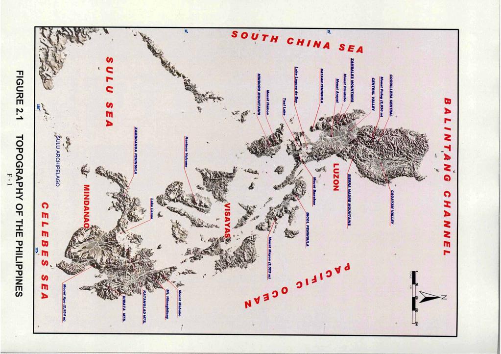
157

158

159

160

161

162

163

164
THE STUDY ON FLOOD CONTROL PROJECT IMPLEMENTATION SYSTEM FOR PRINCIPAL RIVERS IN THE PHILIPPINES
 NO. DEPARTMENT OF PUBLIC WORKS AND HIGHWAYS THE REPUBLIC OF THE PHILIPPINES Japan International Cooperation Agency THE STUDY ON FLOOD CONTROL PROJECT IMPLEMENTATION SYSTEM FOR PRINCIPAL RIVERS IN THE PHILIPPINES
WATER-RELATED HAZARDS AND DISASTER RISK IN CAGAYAN RIVER BASIN, PHILIPPINES
 WATER-RELATED HAZARDS AND DISASTER RISK IN CAGAYAN RIVER BASIN, PHILIPPINES Orlando F. Balderama PWRI ICHARM Meeting November 16, 2018 FURUMAI LABORATORY One dead in Isabela town flood during 'Rosita'
Impacts of Drought in the e Philippines
 Department of Science and Technology Department of Science and Technology Philippine Atmospheric, Geophysical and Astronomical Services Administration Impacts of Drought in the e Philippines by Rosalina
WATER RESOURCES IN THE PHILIPPINES: Status, Challenges and Opportunities
 WATER RESOURCES IN THE PHILIPPINES: Status, Challenges and Opportunities SCPW Joy Nostalgia Hotel Manila March 20, 2019 DR. SEVILLO D. DAVID, JR., Executive Director ENGR. SUSAN P. ABAÑO, OIC, Policy and
Water Resources. Inland freshwater (rivers, lakes, and groundwater) Marine (bay, coastal, and oceanic waters) Rainwater
 Marine (bay, coastal, and oceanic waters) Rainwater") Water Resources Inland freshwater (rivers, lakes, and groundwater) Marine (bay, coastal, and oceanic waters) Rainwater The country is endowed with abundant water resources. It experiences an average annual
Water Resources Inland freshwater (rivers, lakes, and groundwater) Marine (bay, coastal, and oceanic waters) Rainwater The country is endowed with abundant water resources. It experiences an average annual
2011/9/ Principal rivers (421 river basins) 18 major river basins (with drainage area greater. 72 lakes Extensive groundwater aquifers
 18 major river basins (with drainage area greater. 72 lakes Extensive groundwater aquifers") VICENTE B. TUDDAO, JR., Ph.D. Executive Director River Basin Control Office Department of Environment and Natural Resources Mandarin Oriental Hotel Makati City, Metro Manila September 21, 2011 421 Principal
VICENTE B. TUDDAO, JR., Ph.D. Executive Director River Basin Control Office Department of Environment and Natural Resources Mandarin Oriental Hotel Makati City, Metro Manila September 21, 2011 421 Principal
Roadmap toward Effective Flood Hazard Map in Lampang Thailand. JICA region-focused training course on flood hazard mapping JFY 2005
 Roadmap toward Effective Flood Hazard Map in Lampang Thailand JICA region-focused training course on flood hazard mapping JFY 2005 Prepared by MR. SOMCHIT AMNATSAN Chief of Water Planning and Solution
List of Agencies Eligible for FY 2015 PBB
 DEPARTMENTS List of Agencies Eligible for FY 2015 PBB 1. Office of the President 2. Office of the Vice President 3. Department of Budget and Management 4. Department of Energy 5. Department of Environment
Flood and Sediment Management in the Philippines, in view of Cooperation. Minoru Kamoto. Version 2009.Nov.6
 Flood and Sediment Management in the Philippines, in view of Cooperation. Minoru Kamoto JICA Advisor of Integrated River Management at the Department of Public Works and Highways (DPWH) Version 2009.Nov.6
Broadening the Scope of the Proportional System of Representation
 Broadening the Scope of the Proportional System of Representation Felix P. Muga II 1. In a paper written by our colleague last March 23, 2016, Prof. Roland G. Simbulan said that we can challenge the oligarchic
Proposal Report. Flood Hazard Mapping Project. City of San Fernando (P)
") Proposal Report on Flood Hazard Mapping Project in City of San Fernando (P) Prepared By DE LEON Efren Mariano Engineer IV City Engineer s Office City of San Fernando, Pampanga Philippines FLOOD HAZARD
Proposal Report on Flood Hazard Mapping Project in City of San Fernando (P) Prepared By DE LEON Efren Mariano Engineer IV City Engineer s Office City of San Fernando, Pampanga Philippines FLOOD HAZARD
Susan P. Abano Engineer IV Policy and Program Division
 National Water Resources Board Integrated Water Resources Management Susan P. Abano Engineer IV Policy and Program Division National Water Resources Board Outline Philippines Water Resources Situationer
DPWH STRATEGIC INFRASTRUCTURE PROGRAMS AND POLICIES
 DPWH STRATEGIC INFRASTRUCTURE PROGRAMS AND POLICIES SECRETARY MARK A. VILLAR Department of Public Works and Highways April 13, 2018 BOLDEST, MOST AMBITIOUS INFRASTRUCTURE PROGRAM IN HISTORY (% TO GDP)
PAGASA and its Flood Early Warning Services. HydroMeteorology Division (HMD)
") and its Flood Early Warning Services HydroMeteorology Division (HMD) HYDROMETEOROLOGY DIVISION ( HMD) (Formerly Flood Forecasting Branch, FFB) WATER-RELATED DISASTER MITIGATION MEASURES MEASURES STRUCTURAL
and its Flood Early Warning Services HydroMeteorology Division (HMD) HYDROMETEOROLOGY DIVISION ( HMD) (Formerly Flood Forecasting Branch, FFB) WATER-RELATED DISASTER MITIGATION MEASURES MEASURES STRUCTURAL
STATE UNIVERSITIES AND COLLEGES PC requirement identified by MITHI
 Annex "1-C" STATE UNIVERSITIES AND COLLEGES funding 214 TOTAL 15,611 5,911 NATIONAL CAPITAL REGION Eulogio 'Amang' Rodriguez Institute of Science and Technology *Marikina Polytechnic College 5 5 Philippine
The Role and Opportunities Of Water Environment in the. Republic of the Union of Myanmar
 The Role and Opportunities Of Water Environment in the Republic of the Union of Myanmar Presented by SOE MYINT Director General (Rtd;) Directorate of Water Resources and Improvement of River Systems (DWIR)
FINAL REPORT (SUMMARY)
") JAPAN INTERNATIONAL COOPERATION AGENCY THE REPUBLIC OF THE PHILIPPINES THE STUDY ON PROGRAM FORMULATION IN DISASTER MITIGATION SECTOR IN THE PHILIPPINES FINAL REPORT (SUMMARY) DECEMBER 2004 COMPOSITION
JAPAN INTERNATIONAL COOPERATION AGENCY THE REPUBLIC OF THE PHILIPPINES THE STUDY ON PROGRAM FORMULATION IN DISASTER MITIGATION SECTOR IN THE PHILIPPINES FINAL REPORT (SUMMARY) DECEMBER 2004 COMPOSITION
Indices and Early Warning Systems in the Philippines
 Holiday Inn Downtown, Lincoln, Nebraska, USA, 8-11 December 2009 Indices and Early Warning Systems in the Philippines Flaviana D. Hilario, Ph.D. Weather Services Chief Climatology and Agrometeorology Division
SHIFTING PARADAIGM OF JAPANESE ASSISTANCE IN DISASTER RISK MANAGEMENT IN THE PHILIPPINES
 SHIFTING PARADAIGM OF JAPANESE ASSISTANCE IN DISASTER RISK MANAGEMENT IN THE PHILIPPINES Mikio Ishiwatari Japan International Cooperation Agency 5-25 Niban-cho, Chiyoda-ku, Tokyo 102-8012 Japan ishiwatarimikio@yahoo.co.jp
ARANGKADA PHILIPPINES 2010: A BUSINESS PERSPECTIVE. Infrastructure: Water
 Infrastructure: Water Sector Background and Potential The dependable supply and distribution of water for urban living as well as agriculture is critical to economic growth and the everyday life of Filipinos.
TOWARDS MAINSTREAMING DISASTER REDUCTION INTO THE PLANNING PROCESS FOR NATIONAL ROADS IN THE DEPARTMENT OF PUBLIC WORKS AND HIGHWAYS, PHILIPPINES
 TOWARDS MAINSTREAMING DISASTER REDUCTION INTO THE PLANNING PROCESS FOR NATIONAL ROADS IN THE DEPARTMENT OF PUBLIC WORKS AND HIGHWAYS, PHILIPPINES By Maria Catalina E. Cabral, PhD Assistant Secretary for
Metro Manila Flood Control Project (II)
") Philippines 1. Project Profile and Japan s ODA Loan Metro Manila Flood Control Project (II) Report Date: March 2001 Field Survey: September 2000 Project site The Philippines Manila Cebu Site Map: Manila
Philippines 1. Project Profile and Japan s ODA Loan Metro Manila Flood Control Project (II) Report Date: March 2001 Field Survey: September 2000 Project site The Philippines Manila Cebu Site Map: Manila
Implementation Status & Results Philippines National Program Support for Environment and Natural Resources Management Project (P096174)
") Public Disclosure Authorized Public Disclosure Authorized The World Bank Implementation Status & Results Philippines National Program Support for Environment and Natural Resources Management Project (P096174)
Public Disclosure Authorized Public Disclosure Authorized The World Bank Implementation Status & Results Philippines National Program Support for Environment and Natural Resources Management Project (P096174)
Water Governance in the Philippines and Some Thoughts on Governance
 Water Governance in the Philippines and Some Thoughts on Governance Guillermo Q. Tabios III Institute of Civil Engineering and National Hydraulic Research Center University of the Philippines at Diliman
Grecile Christopher R. Damo
 REPUBLIC OF THE PHILIPPINES International Centre for Water Hazard and Risk Management (ICHARM) Public Works Research Institute (PWRI) And in cooperation with Japan International Cooperation Agency (JICA)
Country Profile - Republic of Korea INFORMATION
 INFORMATION Geography The Republic of Korea occupies the southern portion of the Korean Peninsula, which extends some 1,100 km from the Asian mainland. This mountainous peninsula is flanked by the Yellow
Climate Change Impact Assessment and Adaptation in the Philippines
 The Fourth GEOSS Asia Pacific Symposium Sanur Paradise Plaza Hotel and Suites, Bali, Indonesia 10 12 March 2010 Climate Change Impact Assessment and Adaptation in the Philippines Flaviana Hilario Climatology
Designation of Water Quality Management Areas in the Philippines
 Designation of Water Quality Management Areas in the Philippines LEZA A. ACORDA-CUEVAS Supervising Environmental Management Specialist Environmental Management Bureau Department of Environment and Natural
Inter-Agency Task Force on the Harmonization of National Government Performance Monitoring, Information and Reporting Systems
 List of Non-Compliant for State Universities and s 1. Abra State Institute of Science and 2. Apayao State 3. Kalinga-Apayao State 4. Mt. Province State Polytechnic 5. Ilocos Sur Polytechnic State 6. Mariano
Mainstreaming Climate Change into National Urban Policies in the Philippines MAINSTREAMING CLIMATE CHANGE INTO NATIONAL URBAN POLICIES
 Mainstreaming Climate Change into National Urban Policies in the Philippines MAINSTREAMING CLIMATE CHANGE INTO NATIONAL URBAN POLICIES Country name: Philippines Population Country profile 100, 096,496
Inter-Agency Task Force on the Harmonization of National Government Performance Monitoring, Information and Reporting Systems
 List of Non-Compliant for State Universities and s On Going Validation Process 1. Abra Institute of Science and Technology 2. Apayao State 3. Benguet State University 4. Ifugao State University 5. Kalinga-Apayao
PHILIPPINES: ARMM SOCIAL FUND PROJECT ADDITIONAL FINANCING FRAMEWORK AND OPERATIONAL GUIDANCE OF ENVIRONMENTAL SAFEGUARDS 1. (Environment Category B)
") PHILIPPINES: ARMM SOCIAL FUND PROJECT ADDITIONAL FINANCING FRAMEWORK AND OPERATIONAL GUIDANCE OF ENVIRONMENTAL SAFEGUARDS 1 (Environment Category B) The Project The development goals of the proposed Autonomous
PHILIPPINES: ARMM SOCIAL FUND PROJECT ADDITIONAL FINANCING FRAMEWORK AND OPERATIONAL GUIDANCE OF ENVIRONMENTAL SAFEGUARDS 1 (Environment Category B) The Project The development goals of the proposed Autonomous
Linking Corn Production, Climate Information and Farm-Level Decision-Making: A Case Study in Isabela, Philippines
 Chapter 16 Linking Corn Production, Climate Information and Farm-Level Decision-Making: A Case Study in Isabela, Philippines 16.1 Introduction Corn is the second most important crop in the Philippines
Compendium of Case Studies Guidance Notes. Camiguin Province, Island of Mindanao. Date: Natural hazard risk reduction
 COMMUNITY RISK ASSESSMENT AND ACTION PLANNING PROJECT Compendium of Case Studies Guidance Notes Philippines Enhancing Local Government Unit Capacities in Disaster Preparedness, Prevention & Mitigation
Japanese ODA Loan Ex-ante Evaluation
 Japanese ODA Loan Ex-ante Evaluation 1.Name of the Project Country: Republic of the Philippines Project: Pasig-Marikina River Channel Improvement Project (Phase III) Loan Agreement: 30 March 2012 Loan
Philippine Presentation
 National Water Resources Board Philippine Presentation Green Growth on Water Allocation Policy By Engr. Arlene C. Diaz National Water Resources Board Outline Philippine Water Resources Existing Water Allocation
SUSTAINABLE LAND IN THE PHILIPPINES
 SUSTAINABLE LAND MANAGEMENT IN THE PHILIPPINES RODELIO CARATING AND RODRIGO BADAYOS BUREAU OF SOILS AND WATER MANAGEMENT AND UNIVERSITY OF THE PHILIPPINES LOS BAÑOS OUTLINE OF PRESENTATION INTRODUCTION
Managing Disasters in the Philippines
 Regional workshop: Building Resilience to Climate Change Risk and Vulnerability to Meet Water Security Challenges July 1-11, 217 Langkawi, Malaysia Managing Disasters in the Philippines By Mirasol G. Domingo
LAW OF THE REPUBLIC OF INDONESIA NUMBER 7 OF 2004 REGARDING WATER RESOURCES
 LAW OF NUMBER 7 OF 2004 REGARDING WATER RESOURCES BY THE GRACE OF THE ALMIGHTY GOD, THE PRESIDENT OF Considering : a. that water resources is the gift of the Almighty God which gives benefits for the realization
8 MANAGING THE EFFECTS OF NATURAL HAZARDS
 8 MANAGING THE EFFECTS OF NATURAL HAZARDS 8.1 RESOURCE MANAGEMENT ACT OBLIGATIONS 8.1.1 A natural hazard is defined under Section 2 as being Any atmospheric or earth or water related occurrence (including
Challenges to water resource management: ensuring adequate supply and better water quality for the present and future generations
 Challenges to water resource management: ensuring adequate supply and better water quality for the present and future generations Dr. Roberto B. Raymundo School of Economics De La Salle University Manila,
Outline of Presentation
 Climate Change Adaptation in the Agriculture and Water Sectors in the Philippines Juan M. Pulhin Pulhin,, Ph.D. Professor and Scientist II University of the Philippines Los Baños Inception Workshop on
Greening Growth Through HRD Interventions
 Greening Growth Through HRD Interventions Sub-Theme: Strategic Human Resource Development in an Era of "Green Growth ROLANDO L. METIN Career Executive Service Board, Philippines Green Growth as National
Ex-Ante Evaluation (for Japanese ODA Loan)
") Japanese ODA Loan Ex-Ante Evaluation (for Japanese ODA Loan) 1. Name of the Project Country: The Republic of the Philippines Project: Flood Risk Management Project for Cagayan de Oro River Loan Agreement:
Japanese ODA Loan Ex-Ante Evaluation (for Japanese ODA Loan) 1. Name of the Project Country: The Republic of the Philippines Project: Flood Risk Management Project for Cagayan de Oro River Loan Agreement:
Chronic Food Insecurity Situation Overview in 71 provinces of the Philippines
 Chronic Food Insecurity Situation Overview in 71 provinces of the Philippines 2015-2020 Key Highlights Out of the 71 provinces analyzed, Lanao del Sur, Sulu, Northern Samar and Occidental Mindoro are experiencing
Japanese ODA Loan. Ex-Ante Evaluation
 Japanese ODA Loan Ex-Ante Evaluation 1. Project Country: People's Republic of Bangladesh Name of the Project: Haor Flood Management and Livelihood Improvement Project Loan Agreement: June 16, 2014 Loan
Understanding and Addressing the New Normal - The Philippine Experience
 2015/EPWG/SDMOF/003 Agenda: 5.3 Understanding and Addressing the New Normal - The Philippine Experience Submitted by: Philippines 9 th Senior Disaster Management Officials Forum Iloilo, Philippines 22-23
LIST OF POSSIBLE APPLICATIONS OF DECADAL PREDICTION
 LIST OF POSSIBLE APPLICATIONS OF DECADAL PREDICTION Document prepared for CLIVAR Pacific Panel by: William Crawford, Rodney Martinez and Toshio Suga. October 2006 The decadal time period falls between
Holistic Approach to Disaster Reduction in Japan: Towards Total Disaster Risk Management Mr. Satoru Nishikawa
 Holistic Approach to Disaster Reduction in Japan: Towards Total Disaster Risk Management Mr. Satoru Nishikawa Executive Director, Asian Disaster Reduction Center (ADRC), Japan Disaster reduction and sustainable
Soil Types and Geographical Forms of the Degraded Uplands of Bohol, Philippines
 Research article erd Soil Types and Geographical Forms of the Degraded Uplands of Bohol, Philippines JOSE T. TRAVERO* Bohol Island State University, Bohol, Philippines Email: kinandamata@gmail.com Received
SPECIAL OPERATION SO
 WFP Philippines SPECIAL OPERATION SO 200595 Country: Type of project: Title: Philippines Special Operation Logistics and Emergency Telecommunications Augmentation in Response to Typhoon Haiyan in the Philippines
LAGUNA LAKE DEVELOPMENT AUTHORITY. Introduction to
 LAGUNA LAKE DEVELOPMENT AUTHORITY Introduction to LAGUNA DE BAY AND LLDA Presented at the 2 nd Thematic Workshop On Water Rights and Allocation 06 June 2006 La Mesa Dam Old Guesthouse, Quezon City, Philippines
THE MANILA BAY EXPERIENCE
 THE MANILA BAY EXPERIENCE I. Legal Bases II. The OPMBCS III. Interventions Priority Others LEGAL BASES SC ORDER The mandamus agencies are hereby ordered to clean, rehabilitate, and preserve Manila Bay,
Preparing Water Services for Climate Risks: Experience from the Philippines
 Preparing Water Services for Climate Risks: Experience from the Philippines Mona Grieser, Chief of Party, USAID Be Secure Project Paul Violette, Vice President, Environment & Infrastructure, AECOM November
Baseline Information on Climate Change Adaptation and Mitigation Strategies in Pangasinan, Philippines
 Asia Pacific Journal of Multidisciplinary Research, Vol. 5, No. 4, November 2017 Baseline Information on Climate Change Adaptation and Mitigation Strategies in Pangasinan, Philippines Benica S. Briones
ASIAN DISASTER REDUCTION CENTER Visiting Researcher Program (FY2017B)
") JAPAN, 2018 ASIAN DISASTER REDUCTION CENTER Visiting Researcher Program (FY2017B) Viet Nam Country Report 2017 ADRC visiting researcher PHAM HONG THANH Disaster Management Policy And Technology Center
JAPAN, 2018 ASIAN DISASTER REDUCTION CENTER Visiting Researcher Program (FY2017B) Viet Nam Country Report 2017 ADRC visiting researcher PHAM HONG THANH Disaster Management Policy And Technology Center
MANAGING AND REDUCING SOCIAL VULNERABILITY IN THE CONTEXT OF FLOOD RISKS IN MUMBAI
 MANAGING AND REDUCING SOCIAL VULNERABILITY IN THE CONTEXT OF FLOOD RISKS IN MUMBAI S. S. Shinde Jt. Municipal Commissioner Municipal Corporation of Greater Mumbai HAZARDS THAT HAVE IMPACTED OR CAN POTENTIALLY
Vulnerabilities to Climate Change Impacts and Strengthening Disaster Risk Management in East Asian Cities
 Hanoi, Vietnam 2008 Primer Reducing Vulnerabilities to Climate Change Impacts and Strengthening Disaster Risk Management in East Asian Cities I/ CITY DESCRIPTION A. Hanoi Topography and demography characteristics
TABLE OF CONTENTS. Preface. Abbreviations and Acronyms. Executive Summary. Water Quality Hot Spots. Philippines Water Quality at a Glance v
 Philippines Environment Monitor 2003 TABLE OF CONTENTS Preface Abbreviations and Acronyms Executive Summary Water Quality Hot Spots Philippines Water Quality at a Glance v Water Resources, Quality, and
Climate Change Impacts to the Water Environment and Adaptation Options in the Philippines¹. by: Lourdes V. Tibig 2
 Climate Change Impacts to the Water Environment and Adaptation Options in the Philippines¹ by: Lourdes V. Tibig 2 1 Presented at the WEPA first International Workshop held in Hanoi, Vietnam on 8-9 March
Climate uncertainties and RP positions in the UN Framework Convention on Climate Change
 Climate uncertainties and RP positions in the UN Framework Convention on Climate Change Graciano P. Yumul, Jr. Department of Science and Technology Bicutan, Taguig City National Institute of Geological
Outline of Presentation
 Joint Evaluations: Supporting the Government of the Philippines (GPH) Continuing Evaluation Agenda Nikki Ann C. Bermudez Senior Economic Development Specialist Monitoring and Evaluation Staff Asia Pacific
THE DISASTER RISK REDUCTION & MANAGEMENT BILL
 THE DISASTER RISK REDUCTION & MANAGEMENT BILL Prepared by: Disaster Risk Reduction Network Philippines (DRRNetPhils) 1 Why is there a need for a policy for reducing and managing disaster risks in the Philippines?
Title Action Plan toward Effective Flood Hazard Mapping in My Country
 Title Action Plan toward Effective Flood Hazard Mapping in My Country JICA region focused training course on flood hazard mapping Sep 2006 LAI TUAN ANH Division of Geodesy Department of Planning and Management
FLOOD MANAGEMENT IN THE RED THAI BINH RIVER BASIN VIET NAM
 FLOOD MANAGEMENT IN THE RED THAI BINH RIVER BASIN VIET NAM By Dr. To Trung Nghia Director of Institute of Water Resources Planning Chief of the Red Thai Binh RBO Office E-mail: iwrp.hanoi@hn.vnn.vn INTRODUCTION
Initiative for Disaster Reduction through ODA
 Initiative for Disaster Reduction through ODA January 18, 2005 Government of Japan Ⅰ Japan s basic position on disaster reduction The disaster caused by the major earthquake off the coast of Sumatra and
In the name of Allah - The most Beneficent & Merciful
 In the name of Allah - The most Beneficent & Merciful GOVERNMENT OF PAKISTAN INDUS RIVER SYSTEM AUTHORITY PRESENTATION ON WATER RELATED DISASTER AND ITS MANAGEMENT IN PAKISTAN AN ASSESMENT OF WATER RELATED
Summary of Preparatory Study for Development Study (M/P)
") Summary of Preparatory Study for Development Study (M/P) 1. Title of the Cooperation Project The Study on Integrated Water Resources Management for Poverty Alleviation and Economic Development in the Pampanga
Summary of Preparatory Study for Development Study (M/P) 1. Title of the Cooperation Project The Study on Integrated Water Resources Management for Poverty Alleviation and Economic Development in the Pampanga
Disaster Risk Reduction and Climate Change Agenda of the Department of Science and Technology
 Disaster Risk Reduction and Climate Change Agenda of the Department of Science and Technology 6 th National Congress &2018 Philippine Agriculturists Summit Waterfront Hotel, Lahug city July 23, 2018 Renato
PHILIPPINE FRESHWATER RESOURCES: STRATEGIES FOR SUSTAINABLE DEVELOPMENT
 PHILIPPINE FRESHWATER RESOURCES: STRATEGIES FOR SUSTAINABLE DEVELOPMENT RAFAEL D. GUERRERO ill Philippine Council for Aquatic and Marine Research and Development Los Banos. 4031 Laguna ABSTRACT Water is
2.4.0 CLIMATE CHANGE, EXPOSURE & RISK. Contents of Set : Guide 2.4.1: Activity : Activity : Activity 3 IN THIS SET YOU WILL:
 2.4.0 SERIES 2 Understanding Vulnerability & Risk CLIMATE CHANGE, EXPOSURE & RISK Contents of Set 2.4.0: Guide 2.4.1: Activity 1 2.4.2: Activity 2 2.4.3: Activity 3 One component of vulnerability to climate
Supported by: PHILIPPINES. Is the fun drying up? Implications of intensifying El Niño conditions for drought risk and food security
 Supported by: PHILIPPINES Is the fun drying up? Implications of intensifying El Niño conditions for drought risk and food security 2016 CONTENTS KEY MESSAGES 01 FOOD & NUTRITION SECURITY PROFILE 02 THEMATIC
Achieving Natural Disaster Business Success by Developing Clients and Community: Lessons from Local Leading Companies in Nagaoka City, Niigata, Japan
 Achieving Natural Disaster Business Success by Developing Clients and Community: Lessons from Local Leading Companies in Nagaoka City, Niigata, Japan - Japanese flood monitoring experiences for the Philippines
Hydrology and Water Management. Dr. Mujahid Khan, UET Peshawar
 Hydrology and Water Management Dr. Mujahid Khan, UET Peshawar Course Outline Hydrologic Cycle and its Processes Water Balance Approach Estimation and Analysis of Precipitation Data Infiltration and Runoff
Level of Urbanization
 Objectives Overview of urbanization and decentralization in the Philippines Implications of urbanization and decentralization on infrastructure provision Lessons learned Region Level of Urbanization 1960
FINANCIAL INCLUSION IN THE PHILIPPINES: A REGIONAL ASSESSMENT TATUM BLAISE TAN
 FINANCIAL INCLUSION IN THE PHILIPPINES: A REGIONAL ASSESSMENT TATUM BLAISE TAN FINANCIAL INCLUSION IN THE PHILIPPINES Financial inclusion aims at drawing the unbanked population into the formal financial
THE EFFECTS OF URBANIZATION ON THE MINGO CREEK WATERSHED
 THE EFFECTS OF URBANIZATION ON THE MINGO CREEK WATERSHED by Tim Marshall (presented at the Sixth Conference on Hydrometeorology in Indianapolis, IN, 1984) 1. INTRODUCTION Urbanization of flood plains presents
The Report of the East Asian Seas Congress in Manila, Philippines -Partnerships At Work : Local Implementation and Good Practices
 IGU-Commission on Hazard and Risk 2008-2012 Commission Shigeko HARUYAMA, Chair The Report of the East Asian Seas Congress in Manila, Philippines -Partnerships At Work : Local Implementation and Good Practices
7. NATURAL HAZARDS 7.1 SECTION INTRODUCTION
 7. NATURAL HAZARDS 7.1 SECTION INTRODUCTION 7.1.1 The Resource Management Act empowers Council to control any actual or potential effects of the use, development, or protection of land for the purpose
Livelihood adaptations in upland, lowland and coastal ecosystems of Infanta, Quezon: A decade after the flashflood disaster
 Expert Conference on Development of Island's Sustainable Societies 29-30 June, 2014 Okinawa, JAPAN Livelihood adaptations in upland, lowland and coastal ecosystems of Infanta, Quezon: A decade after the
GEO-DRI Drought Monitoring Workshop, May 10-11, 2010, Winnipeg, Manitoba Drought in Southeast Asia
 GEO-DRI Drought Monitoring Workshop, May 10-11, 2010, Winnipeg, Manitoba Drought in Southeast Asia Orn-uma Polpanich Stockholm Environment Institute Asia Bangkok, Thailand Southeast Asia Is located on
4/24/2009. Sustainable soil and water resources management. Importance of hydrologic info in sustainable soil and water resources mgt.
 Potential Applications of the SWAT Model for Sustainable Soil and Water Resources Management in Southeast Asia By Victor B. Ella, Ph.D. Professor and Former Dean College of Engineering and Agro-industrial
CHAPTER ONE : INTRODUCTION
 CHAPTER ONE : INTRODUCTION WHAT IS THE HYDROLOGY? The Hydrology means the science of water. It is the science that deals with the occurrence, circulation and distribution of water of the earth and earth
THE STUDY ON INTEGRATED URBAN DRAINAGE IMPROVEMENT FOR MELAKA AND SUNGAI PETANI IN MALAYSIA FINAL REPORT
 THE GOVERNMENT OF MALAYSIA PRIME MINISTER S DEPARTMENT ECONOMIC PLANNING UNIT THE STUDY ON INTEGRATED URBAN DRAINAGE IMPROVEMENT FOR MELAKA AND SUNGAI PETANI IN MALAYSIA FINAL REPORT VOL. 5: TECHNICAL
Catchment Area Length Remarks Dinanggasan ,300* *Excluding Tributary Tag-Ibo 2.9 3,800 Tributary
 Main Report Chapter 5 The Study on the Nationwide Flood Risk Assessment and the Flood Mitigation Plan for the Selected Areas in the Republic of the Philippines 5.7 Dinanggasan River Basin 5.7.1 Basin Conditions
Case Study. Defence climate change risk assessment. Overview. Background
 Case Study Defence climate change risk assessment Overview This case study describes the process used by the Australian Department of Defence to undertake climate risk assessments and adaptation planning
Juan M. Pulhin, Ph.D. Professor College of Forestry and Natural Resources University of the Philippines Los Baños
 Revisiting the Socio-economic Impacts of the 2004 Typhoon Disaster in the Philippines: Implications to Environmental Governance and Climate Change Adaptation Juan M. Pulhin, Ph.D. Professor College of
PLANNING AND DESIGNING FOR CLIMATE ADAPTIVE AND RESILIENT TRANSPORT: EXPERIENCE FROM PHILIPPINES
 The Republic of the Philippines DEPARTMENT OF PUBLIC WORKS AND HIGHWAYS PLANNING AND DESIGNING FOR CLIMATE ADAPTIVE AND RESILIENT TRANSPORT: EXPERIENCE FROM PHILIPPINES Engineer ERNESTO V. ALDAY, JR Project
Member s Annual Report Date of preparation :3/28/08 Name of the editor : Atty. Elenito M. Bagalihog
 1. About the Organization Member s Annual Report 2007 Date of preparation :3/28/08 Name of the editor : Atty. Elenito M. Bagalihog (1) Name of the organization and postal address of the office National
Disaster Reduction Programme in Myanmar
 Disaster Reduction Programme in Myanmar Dr. Toe Toe Win Associate Professor Civil Engineering Department Yangon Technological University Yangon Union of Myanmar Myanmar Overview The Union of Myanmar is
2014/ATCWG/013 Analysis and Mapping of Impacts under Climate Change for Adaptation and Food Security (AMICAF) Activities in the Philippines
 Activities in the Philippines") 2014/ATCWG/013 Analysis and Mapping of Impacts under Climate Change for Adaptation and Food Security (AMICAF) Activities in the Philippines Purpose: Information Submitted by: Philippines 18 th Agricultural
2014/ATCWG/013 Analysis and Mapping of Impacts under Climate Change for Adaptation and Food Security (AMICAF) Activities in the Philippines Purpose: Information Submitted by: Philippines 18 th Agricultural
Angat Water Transmission Improvement Project
 Angat Transmission Improvement Project Updated on October 29, 2018 Region III Central Luzon PhP 3.3 billion ADB Cooperativa Muratori and Cementisti Construction started October 26, 2016 Target completion
Climate Risks and Adaptation in Asian Coastal Megacities
 Climate Risks and Adaptation in Asian Coastal Megacities Local Climate Solutions for Africa 2011, ICLEI, Cape Town Poonam Pillai Sr. Environmental Specialist World Bank Presentation based on joint WB,
Water Related Challenges in Asia - A Tale Of Three Cities -
 Water Related Challenges in Asia - A Tale Of Three Cities - St. Regis Hotel Washington DC 17 October, 2014 Keizrul bin Abdullah Chairperson Network of Asian River Basin Organizations (NARBO) 3 Case Studies
(1) Bridge, Road and Railway (Adaptation Project) (2) Bridge, Road and Railway (BAU Development with Adaptation Options)
 Bridge, Road and Railway (Adaptation Project) (2) Bridge, Road and Railway (BAU Development with Adaptation Options)") Sub-sector Guideline: (1) Bridge, Road and Railway (Adaptation Project) (2) Bridge, Road and Railway (BAU Development with Adaptation Options) Basic Concept A. General Concept Climate change will increase
Sub-sector Guideline: (1) Bridge, Road and Railway (Adaptation Project) (2) Bridge, Road and Railway (BAU Development with Adaptation Options) Basic Concept A. General Concept Climate change will increase
Climate Change Country Profile: Viet Nam
 Climate Change Country Profile: Viet Nam 1. Country description 1.1 Geography Located in South-East Asia Borders China, Lao People s Democratic Republic, Cambodia and East Sea Coastline: 3260 km Total
Philippine experiences in the implementation of initiatives that address Climate Change and Land Degradation. and Land Degradation
 World Meteorological Organization Philippine experiences in the implementation of initiatives that address Climate Change and Land Degradation International Workshop on Climate Change and Land Degradation
Japan s Urbanization and Growth Processes. Hiroto Arakawa Senior Special Advisor, JICA
 Japan s Urbanization and Growth Processes Hiroto Arakawa Senior Special Advisor, JICA 1 Purpose of Presentation The Growth Report (2008) by Commission on Growth and Development - Discusses urbanization
Recovery from Typhoon Haiyan: Two Years After
 United Nations Development Programme Build Back Better Recovery from Typhoon Haiyan: Two Years After Alma Evangelista UNDP Philippines 17 November 2015 Danang, Vietnam Pacific Typhoon Belt Increasing Frequency