A Review of the San Clemente Dam Removal & Carmel River Reroute Project
|
|
|
- Martin Ellis
- 6 years ago
- Views:
Transcription


 Technical")

1 A Review of the San Clemente Dam Removal & Carmel River Reroute Project Kevan Urquhart, Senior Fisheries Biologist & Carmel River Watermaster MPWMD Project Roles: 1) CDFW rep ; 2) Technical Advisory Committee member for MPWMD
![Lead Agencies & Staff California American Water [Cal Am], J. Aman Gonzalez, P.E.](/docs-images/77/75926344/images/2-0.jpg "NMFS, Joyce Ambrosius & Jacqueline Pearson Meyer State Coastal Conservancy, Trish Chapman L to R")
2 Lead Agencies & Staff California American Water [Cal Am], J. Aman Gonzalez, P.E. NMFS, Joyce Ambrosius & Jacqueline Pearson Meyer State Coastal Conservancy, Trish Chapman L to R -Joyce A. & Trish C.


3 Design Build Team Design Build Team Granite Construction Construction Lead Kleinfelder Design Lead Tetratech Design Lead, Channel Restoration Owner s Team Water Systems Consulting Construction Management AECOM Owner s Engineer

4 tc4 Watershed Map
5 Slide 4 tc4 see sample slides tchapman, 2/10/2016


6 $83 Million Total Cost
7 Factors Driving Dam Removal Seismic Safety Earthquake + Probable Maximum Flood = loss of life & damage ~1500 properties for 3+ miles downstream. DWR DSOD rated as the most unsafe dam left in CA Create Volitional Fish Passage Removing the steepest fish ladder in western North America Faster & better access to ~60% of the watershed s steelhead habitat Stream Function Restore natural sediment transport & habitat connectivity
8 Original Impediments to Dam Removal CAW required by CPUC to select least cost alternative CAW required by DWR DSOD to pick fastest alternative No feasible dam removal option was originally identified in first 2008 EIR CAW not familiar with restoration projects Long term liability for any removal project
9 Factors Driving the Reroute Option Reinforcement least expensive & feasible, but still subject to earthquake risk & unstable rock face on north abutment. Required harsh annual sluicing of accumulated sediment to maintain fish passage Community opposition to trucking sediment precluded dredging & recovery of ~1,200+ AF of storage or natural channel restoration ~250,000 dump/~125,000 double trailer trucks required ~8 10 years, 6 12 m/yr, every 5 10 min, 24/7 or 9 4, weekdays Gradual dam removal & resuspension of ~1300 cubic yards of sediment created downstream flood liability for Cal Am, may have affected habitat quality for up to 40+ years, & required interim trap and truck Minimize long term project liability final landowner
10 Negative Impacts of SCD and the Reservoir s Sediment Field Steep ladder may have delayed adult immigration & blocked smaller fish Annual draw down for seismic safety from curtailed late season adult immigration, & reduced downstream water quality Bare sediment field of inundation zone & minimum pool heated river water, created severe algal blooms, impaired downstream juvenile redistribution + fall pre smolt emigration, & enhanced avian predation
11 Design Objectives Eliminate dam safety issue. Bank accumulated sediment on site, resistant to P.M.F. = 81,200 CFS & M.C.Earthquake = 6.7 Richter Scale + Avoid trucking/sluicing impacts Restore volitional upstream passage for adults, and larger juveniles + Enhance downstream passage & survival of juveniles Restore natural sediment transport for spawning gravel & beach replenishment + restore habitat connectivity Create an aesthetic solution & convert to public land (BLM) linked to regional park & potential full river trail

12 Project Timeline
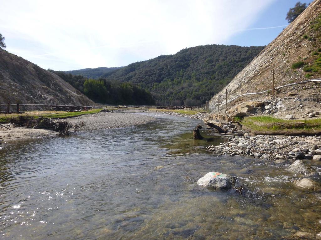
13 History of San Clemente Dam Constructed in 1921 by Del Monte Properties, later sold to California Water and Telephone Company; Purchased by CAW in the 1960 s 106 feet tall concrete arch dam Reservoir storage of 1,425/2,136 AF Spillway crest elevation of 525 feet Spillway capacity of 20,800 CFS Declared seismically unsafe in 1992 Ceased being used as a water supply in 2001 due to sedimentation & ESA Slide 12

14 Recent Historic Photo 1982


15 Stop Logs = AF of Storage

16 Flood Photo 16,000 CFS Failure Risk = Peak discharge of 76,700 CFS 5 minutes after dam breach

17 Sediment Field Intrusion Storage Reduced From 1425 to <90 AF

18

19 Pre Project Site Video


20 Reroute and Removal Project Reroute Channel Diversion Dike Reconstructed Combined Flow Reach Sediment Stockpile Stabilized Sediment Slope Remove Dam
21 Active Project Drone Fly Over


22 Recent Post Project Photos After Initial CFS Peak Flow

23
24

25

26

27

28
29 Up to 5 Years of Post Project Evaluations NMFS SWFSC: BACI study USGS: TSS monitoring CSUMB WMI: Morphological Channel Monitoring & LWD Surveys MPWMD: Redd surveys Granite & MPWMD: Habitat Typing & BMI MPWMD & Cal Am: SH counts above & below project LPD RM 25, & RM3 Potential cooperative PIT tagging & arrays w. MPWMD/NMFS SWFSC/CSUMB WMI
30 Lessons Learned Extensive outreach and site tours sustained community support On line presence and live site cameras sustained transparency and community interest Be prepared for larger than expected effects of bypass flow losses & construction dewatering/treatment on downstream flow in dryer years Be prepared to modify permits to take advantage of water year types to enhance project efficiency & extend work window when feasible Feasible construction bypass flow pipes may not be optimal fish passage devices Secure Access to large rock and spawning gravel for channel construction far in advance Plan to recover or remobilize spawning gravel, if feasible Take advantage of the opportunity to do simultaneous river projects, yet avoid compounded risks by planning to manage cumulative impacts Design build requires an extensive team of engaged expert advisors and regulators, with decision making authority, readily available to make real time management decisions on necessary project adjustments

31 A Steelhead's Journey by Ben Lovejoy What We re All Striving For


32 Old Carmel River Dam


33 Sluice Gate High & Low Flow Access
Water and Environment. Monterey Peninsula, Carmel Bay and South Monterey Bay Integrated Regional Water Management Draft Plan
 Water and Environment Monterey Peninsula, Carmel Bay and South Monterey Bay Integrated Regional Water Management Draft Plan December 11, 2006 Presentation Outline Purpose of IRWM Planning Status of Plan
ANNUAL PROGRESS REPORT FOR 2014 ROGUE RIVER SPRING CHINOOK SALMON CONSERVATION PLAN ROGUE WATERSHED DISTRICT OREGON DEPARTMENT OF FISH AND WILDLIFE
 ANNUAL PROGRESS REPORT FOR 2014 ROGUE RIVER SPRING CHINOOK SALMON CONSERVATION PLAN ROGUE WATERSHED DISTRICT OREGON DEPARTMENT OF FISH AND WILDLIFE INTRODUCTION In September of 2007, the Oregon Fish and
Lower Columbia River Pile Dike Assessment
 Lower Columbia River Pile Dike Assessment David Gorman, PE August 2, 2011 Credits Hans R. Moritz, US Army Corps of Engineers Portland District Carl Kassebaum, AECOM Project Manager AECOM Coastal and Rivers
Annex I Lyons Ferry Hatchery Modification Plan
 Annex I Lyons Ferry Hatchery Modification Plan Table I1 Figure I1 Figure I2 Figure I3 Figure I4 Figure I5 Well Characteristics Lyons Ferry Hatchery Vicinity Map Lyons Ferry Hatchery Site Plan Water Supply
CHAPTER 7. San Dieguito River Flooding Adaptation
 CHAPTER 7 San Dieguito River Flooding Adaptation This chapter includes a range of adaptation measures to address vulnerabilities from flooding along the San Dieguito River, including the river valley,
Chehalis Basin Strategy Programmatic SEPA Draft EIS
 Chehalis Basin Strategy Programmatic SEPA Draft EIS History of Flooding I-5 closed in 1990, 1996, 2007, 2009 Five largest flood events occurred since 1986 2 History of Habitat Degradation Harvest has been
EMERGENCY STORAGE PROJECT San Vicente Pipeline and San Vicente Dam Raise Update Presentation Summary
 EMERGENCY STORAGE PROJECT San Vicente Pipeline and San Vicente Dam Raise Update Presentation Summary DATE: Nov. 2, 2005 EVENT: MEETING LOCATION: PRESENTER(S): STAFF RESOURCES: TIME: 7:30 p.m. Lakeside
FY16 RSM IPR Portland District, Optimizing Fall Creek Reservoir Flush TMDL s, Stanford Gibson, Chris Nygaard, Jim Crain, Jarod Norton
 Fall Creek Reservoir Fall Creek Dam is at river mile 7.2 on Fall Creek, a tributary of the Willamette River, about 20 miles southeast of Eugene, OR. Dam works in coordination with Lookout Point and Hills
United States Department of the Interior
 United States Department of the Interior FISH AND WILDLIFE SERVICE Red Bluff Fish & Wildlife Office 10950 Tyler Road, Red Bluff, California 96080 (530) 527-3043, FAX (530) 529-0292 July 20, 2015 To: Guy
Flow-ecology relationships. Flow-ecology relationships Susitna case study
 Flow-ecology relationships Flow-ecology relationships Susitna case study Flow regime Ecologically-Relevant Flow Regime Characteristics Seasonal or typical conditions Annual extreme conditions High and
SECTION 5.0 ACTION 4 - ENGLEBRIGHT DAM REMOVAL
 SECTION 5.0 ACTION 4 - ENGLEBRIGHT DAM REMOVAL This Section presents facilities design and cost information for Englebright Dam Removal Action (Action 4). Action 4 includes improvements to Daguerre Point
Ponds. Pond A water impoundment made by excavating a pit, or constructing a dam or an embankment.
 POND SITE SELECTION AND CONSTRUCTION Uses, Planning, & Design David Krietemeyer Area Engineer USDA-NRCS June 20, 2008 Uses Considerations for Location of Commonly Used Terms Pond A water impoundment made
Freight Street Development Strategy
 Freight Street Development Strategy Appendix B: Naugatuck River Floodplain Analysis Freight Street Development Strategy DECEMBER 2017 Page B-1 1.0 NAUGATUCK RIVER FLOODPLAIN AT FREIGHT STREET 1.1 Watershed
Geneva Dam. Design of a Steep, Temporary, Riprap Ramp
 Geneva Dam Design of a Steep, Temporary, Riprap Ramp A Run-of of-river Dam Analysis for Geneva Dam Credit to: Yu-Chun Su, Ph.D., P.E., CFM David T. Williams. Ph.D., P.E, CFM Presentation Purpose History
Criteria for Identifying and Prioritizing Habitat Protection and Restoration Projects on the Lower Columbia River and Estuary*
 Criteria for Identifying and Prioritizing Habitat Protection and Restoration Projects on the Lower Columbia River and Estuary* Ecosystem Criteria 1) Habitat Connectivity (0-10 points) This criterion recognizes
Estimation of rearing habitat requirements of San Joaquin River Chinook salmon using the Emigrating Salmonid Habitat Estimation (ESHE) Model
 Model") Estimation of rearing habitat requirements of San Joaquin River Chinook salmon using the Emigrating Salmonid Habitat Estimation (ESHE) Model California Central Valley Cramer Fish Sciences *Draft conceptual
Estimation of rearing habitat requirements of San Joaquin River Chinook salmon using the Emigrating Salmonid Habitat Estimation (ESHE) Model California Central Valley Cramer Fish Sciences *Draft conceptual
United States Army Corps of Engineers. Addicks and Barker Dam Safety Update
 United States Army Corps of Engineers Addicks and Barker Dam Safety Update COL Richard P. Pannell District Commander, Galveston District U.S. Army Corps of Engineers March 9, 2016 US Army Corps of Engineers
SUPERSEDED. BDCP Conservation Measure 1: Water Facilities and Operation. BDCP Bay Delta Conservation Plan
 BDCP Bay Delta Conservation Plan March 2013 BDCP Conservation Measure 1: Water Facilities and Operation A cornerstone of the Bay Delta Conservation Plan (BDCP) strategy is to construct and operate a dual-conveyance
Created by Simpo PDF Creator Pro (unregistered version) Asst.Prof.Dr. Jaafar S. Maatooq
 Asst.Prof.Dr. Jaafar S. Maatooq") Lect.No.9 2 nd Semester Barrages, Regulators, Dams 1 of 15 In order to harness the water potential of a river optimally, it is necessary to construct two types of hydraulic structures, as shown in Figure
Lect.No.9 2 nd Semester Barrages, Regulators, Dams 1 of 15 In order to harness the water potential of a river optimally, it is necessary to construct two types of hydraulic structures, as shown in Figure
NOTICE OF PREPARATION
 NOTICE OF PREPARATION Date: June 12, 2014 To: From: Subject: Governor s Office of Planning and Research/State Clearinghouse Unit, Responsible Agencies, Trustee Agencies, and Interested Parties Announcement
Watershed size and name: The drainage area is acres. The pond is located within the Ohio River watershed. (2016 Inflow Design Plan)
") A. B. Brown History of Construction 40 CFR 257.73 (c) (i.) (ii.) (iii.) Owner Name: Southern Indiana Gas and Electric Company dba Vectren Power Supply Owner Address: One Vectren Square, PO Box 209, Evansville,
A. B. Brown History of Construction 40 CFR 257.73 (c) (i.) (ii.) (iii.) Owner Name: Southern Indiana Gas and Electric Company dba Vectren Power Supply Owner Address: One Vectren Square, PO Box 209, Evansville,
Honeysuckle Reservoir decommissioning
 Honeysuckle Reservoir decommissioning Christopher Dwyer Earth Tech, PO Box 165 Wangaratta, 3676. Web: www.earthtech.com.au, Email: chris.dwyer@earthtech.com.au Abstract Often significant investment is
Spring Forecast Based Operations, Folsom Dam, California
 Spring Forecast Based Operations, Folsom Dam, California Paul E. Pugner, P.E. Chief, Water Management Section Sacramento District U.S. Army 1325 J Street, Room 1126 Sacramento, CA 95814-2922 Tel: (916)
Mr. Paul Dunlap, California Department of Water Resources
 Memorandum To: From: Mr. Paul Dunlap, California Department of Water Resources Oroville Dam Spillway Incident Independent Forensic Team Date: September 5, 2017 Re: Interim Status Memorandum Introduction
EFFECT OF UPSTREAM DEVELOPMENT ON THE CLEAR CREEK AREA
 EFFECT OF UPSTREAM DEVELOPMENT ON THE CLEAR CREEK AREA Technical Memorandum Farming in the Floodplain Project Prepared for May 2017 PCC Farmland Trust Photo credit: Google Earth TABLE OF CONTENTS Page
CALFED Ecosystem Restoration Program (ERP)
") CALFED Ecosystem Restoration Program (ERP) The goal of the Ecosystem Restoration Program is to improve and increase aquatic and terrestrial habitats and improve ecological functions in the Bay-Delta to
CALFED Ecosystem Restoration Program (ERP) The goal of the Ecosystem Restoration Program is to improve and increase aquatic and terrestrial habitats and improve ecological functions in the Bay-Delta to
4.1 Introduction and Approach
 Chapter 4 Impact Assessment and Level of Take 4.1 Introduction and Approach This chapter addresses the effects of the covered activities described in Chapter 2 Land Use and Covered Activities on covered
7.0 SUMMARY AND CONCLUSIONS
 7.0 SUMMARY AND CONCLUSIONS 7.1 SUMMARY This report results from a Washington State Legislature grant to study the feasibility of storing additional water in Lake Wenatchee. The Legislature acted upon
LAWSUIT TO PROTECT SALMON FROM PESTICIDES UNDER THE ENDANGERED SPECIES ACT
 LAWSUIT TO PROTECT SALMON FROM PESTICIDES UNDER THE ENDANGERED SPECIES ACT Background Information on Pesticides and Salmon Pesticides have profound effects on Northwest salmon and may be a serious factor
Phase II Report on Hydrology, Hydraulics, and Low Water Dams
 Phase II Report on Hydrology, Hydraulics, and Low Water Dams Arkansas River Corridor Tulsa, OK May 2005 Submitted To: U. S. Army Corps of Engineers Tulsa District Prepared by: The GUERNSEY Team 5555 N.
Final Total Maximum Daily Load for the Monongahela River, Greene County PCBs and Chlordane
 Final Total Maximum Daily Load for the Monongahela River, Greene County PCBs and Chlordane Point Marion Lock and Dam to Grays Landing Lock and Dam March 1, 1999 Table of Contents Introduction Background
TVA Colbert Fossil Facility Ash Disposal Pond 4
 2011 World of Coal Ash (WOCA) Conference May 9-12, 2011 in Denver, CO, USA http://www.flyash.info/ TVA Colbert Fossil Facility Ash Disposal Pond 4 Improving Operations While Preparing for Closure May 10,
LOWER YUBA RIVER GRAVEL AUGMENTATION PROJECT
 LOWER YUBA RIVER GRAVEL AUGMENTATION PROJECT YUBA AND NEVADA COUNTIES, CALIFORNIA DRAFT SUPPLEMENTAL ENVIRONMENTAL ASSESSMENT June 2013 Approved for public release; distribution is unlimited REPLY TO ATTENTION
Queen Charlotte Islands Project
 Queen Charlotte Islands Project 1981 Introduction The Queen Charlotte Islands Fish-Forestry Interaction Program was an interdisciplinary study assessing the interactions between timber harvesting operations
Introduction. General Description
 Introduction General Description The 3-Gorges project is a vitally important and backbone project in the development and harnessing of the Yangtze River (Changjiang River). The dam site is situated at
WATERSHED MANAGEMENT INITIATIVE: GOALS & IMPLEMENTATION OBJECTIVES, JULY 26, 1999
 WATERSHED MANAGEMENT INITIATIVE: GOALS & IMPLEMENTATION OBJECTIVES, JULY 26, 1999 The following table indicates the draft goals and objectives for the Santa Clara Basin WMI process. The overall objectives
STETSON ENGINEERS INC. HANSON ENVIRONMENTAL,INC. IBIS ENVIRONMENTAL SERVICES. February 2004 Revised
 FINAL DRAFT ARROYO GRANDE CREEK HABITAT CONSERVATION PLAN (HCP) AND ENVIRONMENTAL ASSESSMENT/INITIAL STUDY (EA/IS) FOR THE PROTECTION OF STEELHEAD AND CALIFORNIA RED-LEGGED FROGS February 2004 Revised
7 Mineral and Energy Resources
 7 Mineral and Energy Resources This chapter examines Humboldt County s mineral (including sand and gravel extraction) and energy (oil, gas, and geothermal) resources. Existing General Plan policies and
Are Juvenile Chinook Salmon Entrained at Unscreened Diversions in Direct Proportion to the Volume of Water Diverted?
 Are Juvenile Chinook Salmon Entrained at Unscreened Diversions in Direct Proportion to the Volume of Water Diverted? Charles H. Hanson Abstract Mark-recapture experiments were used to test the null hypothesis
Facts About Pesticides, Salmon, and the Endangered Species Act
 Facts About Pesticides, Salmon, and the Endangered Species Act Background Information on Pesticides and Salmon Pesticides have profound effects on Northwest salmon and may be a serious factor in their
APPENDIX H Guidance for Preparing/Reviewing CEQA Initial Studies and Environmental Impact Reports
 APPENDIX H H.1 Guidance for Preparing and Reviewing CEQA Initial Studies Step 1: Consider the Project Characteristics as Provided by the Project Applicant Review the project application and draft plan
Notice No Closing Date: May 12, 2017
 Public Notice U.S. Army Corps of Engineers Pittsburgh District In Reply Refer to Notice No. below US Army Corps of Engineers, Pittsburgh District 1000 Liberty Avenue Pittsburgh, PA 15222-4186 Application
Temporary Watercourse Crossing: Culverts
 Temporary Watercourse Crossing: Culverts DRAINAGE CONTROL TECHNIQUE Low Gradient Velocity Control Short Term Steep Gradient Channel Lining Medium-Long Term Outlet Control Soil Treatment Permanent Symbol
SOUTH FORK AMERICAN RIVER (CHILI BAR), CALIFORNIA
, CALIFORNIA") Hydropower Project Summary SOUTH FORK AMERICAN RIVER (CHILI BAR), CALIFORNIA CHILI BAR HYDROELECTRIC PROJECT (P-2155) Photo Credit: PG&E This summary was produced by the Hydropower Reform Coalition and
Hydropower Project Summary SOUTH FORK AMERICAN RIVER (CHILI BAR), CALIFORNIA CHILI BAR HYDROELECTRIC PROJECT (P-2155) Photo Credit: PG&E This summary was produced by the Hydropower Reform Coalition and
DES MOINES RIVER RESERVOIRS WATER CONTROL PLAN UPDATES IOWA ASCE WATER RESOURCES DESIGN CONFERENCE
 DES MOINES RIVER RESERVOIRS WATER CONTROL PLAN UPDATES 237 237 237 217 217 217 200 200 200 0 0 0 163 163 163 131 132 122 80 119 27 252 174.59 110 135 120 112 92 56 IOWA ASCE WATER RESOURCES DESIGN CONFERENCE
This is a digital document from the collections of the Wyoming Water Resources Data System (WRDS) Library.
 Library.") This is a digital document from the collections of the Wyoming Water Resources Data System (WRDS) Library. For additional information about this document and the document conversion process please contact
This is a digital document from the collections of the Wyoming Water Resources Data System (WRDS) Library. For additional information about this document and the document conversion process please contact
Good morning, Chairman Yaw, Chairman Yudichak, Chairman Vulakovich, Chairman Costa,
 Testimony of Patrick McDonnell, Secretary Pennsylvania Department of Environmental Protection Joint Hearing on Flooding and Emergency Response Senate Environmental Resources & Energy and Veterans Affairs
The Dalles East Fish Ladder Auxiliary Water System Emergency Operation Backup System Alternatives Columbia River, Oregon-Washington
 U.S. Army Corps of Engineers, Portland District (Contract No. W9127N-08-D-0006) Task Order No. 0026 DRAFT Brainstorming Meeting Report The Dalles East Fish Ladder Auxiliary Water System Emergency Operation
Lyon Creek Cedar Way Stormwater Detention Dam Operation and Maintenance Manual
 Lyon Creek Cedar Way Stormwater Detention Dam Operation and Maintenance Manual Prepared by: Mike Shaw Stormwater Program Manager City of Mountlake Terrace January 2010 Section I General Information This
Appendix D - Evaluation of Interim Solutions
 Appendix D - Evaluation of Interim Solutions D.1 Introduction The implementation of long-term improvements is projected to take 5 to 8 years. To reduce the number of years of flooding impacts, the partner
Iron Mountain Mine Shasta County, California
 CASE STUDY Iron Mountain Mine Shasta County, California August 2010 Prepared by The Interstate Technology & Regulatory Council Mining Waste Team Permission is granted to refer to or quote from this publication
RED RIVER FLOODWAY OPERATION REPORT SPRING Manitoba Infrastructure
 RED RIVER FLOODWAY OPERATION REPORT SPRING 2017 Manitoba Infrastructure RED RIVER FLOODWAY OPERATION REPORT SPRING 2017 June 29, 2017 Manitoba Infrastructure Hydrologic Forecasting and Water Management
Lower Yuba River Redd Dewatering and Fry Stranding Study 2008 Annual Report
 Lower Yuba River Redd Dewatering and Fry Stranding Study 2008 Annual Report Prepared for: Yuba County Water Agency 1220 F Street Marysville, CA 95901 Contact: Curt Aikens 530/741-6278 Prepared by: ICF
PARR HYDROELECTRIC PROJECT PARR HYDRO DEVELOPMENT & FAIRFIELD PUMPED STORAGE FACILITY DEVELOPMENT FERC PROJECT No SC SEPTEMBER 19, 2012
 PARR HYDROELECTRIC PROJECT PARR HYDRO DEVELOPMENT & FAIRFIELD PUMPED STORAGE FACILITY DEVELOPMENT FERC PROJECT No. 1894 - SC SEPTEMBER 19, 2012 PARR AND FAIRFIELD LOCATIONS Lockhart Neal Shoals Monticello
APPENDIX D WATER DRAFTING GUIDELINES. D-1 NMFS Water Drafting Specifications. D-2 DFG Guidelines for Temporary Water Drafting: Preliminary Draft
 APPENDIX D WATER DRAFTING GUIDELINES D-1 NMFS Water Drafting Specifications D-2 DFG Guidelines for Temporary Water Drafting: D-1 NMFS - WATER DRAFTING WATER-DRAFTING SPECIFICATIONS National Marine Fish
Appendix VI: Illustrative example
 Central Valley Hydrology Study (CVHS) Appendix VI: Illustrative example November 5, 2009 US Army Corps of Engineers, Sacramento District Prepared by: David Ford Consulting Engineers, Inc. Table of contents
Information for File # PRH
 Information for File # 2016-02602-PRH Applicant Corps Contact Tom Morley Paul Hauser Address 152 Baker Drive, Redwood Falls, MN 56283 E-Mail Paul.R.Hauser@usace.army.mil Phone 651-290-5357 Primary County
Overview of Recent Developments in California Environmental Laws
 Overview of Recent Developments in California Environmental Laws Northwest Hydropower Conference March, 2009 James M. Lynch, Partner K&L Gates LLP (206) 370-6587 jim.lynch@klgates.com FERC Licensed Hydropower
Blanche Park Reservoir Decision Notice and Finding of No Significant Impact
 Blanche Park Reservoir Decision Notice and Finding of No Significant Impact U.S. Forest Service Grand Mesa, Uncompahgre, and Gunnison National Forests Delta County, Colorado INTRODUCTION The Grand Mesa
Monterey Peninsula, Carmel Bay, and South Monterey Bay Integrated Regional Water Management Plan
 Monterey Peninsula, Carmel Bay, and South Monterey Bay California American Water Stakeholders Monterey Bay Citizen Watershed Monitoring Network California Coastal Commission Monterey County Service Area
REQUEST FOR PROPOSAL
 REQUEST FOR PROPOSAL Submittal Deadline: 5:00 pm July 7, 2017 The Vermont Chapter of The Nature Conservancy invites proposals from qualified consultants for two fish passage restoration projects on culverts
Re: Stanford Habitat Conservation Plan and Draft Environmental Impact Statement Revised and Sent August 30, 2010
 Gary Stern San Francisco Bay Region Supervisor National Marine Fisheries Service 777 Sonoma Ave., Room 325 Santa Rosa, CA 95404 August 29, 2010 Re: Stanford Habitat Conservation Plan and Draft Environmental
Culvert Sizing procedures for the 100-Year Peak Flow
 CULVERT SIZING PROCEDURES FOR THE 100-YEAR PEAK FLOW 343 APPENDIX A: Culvert Sizing procedures for the 100-Year Peak Flow A. INTRODUCTION Several methods have been developed for estimating the peak flood
Green River Diversion Rehabilitation
 USDA Natural Resources Conservation Service-Utah Wallace F. Bennett Federal Building 125 S. State Street Room 4010 Salt Lake City, UT 84138-1100 Green River Diversion Rehabilitation National Environmental
Theme and Project-Specific Studies
 Appendix D 2015 Monitoring and Analysis Plan January 2015 Table of Contents Tables Table 1. 2015 Monitoring and Analysis Plan Theme and Project- Specific Studies...2 Studies Study 8 Egg Survival and Emergence
PRENTISS CREEK (SUB-E) KENSINGTON PLACE CONCEPT PLAN VILLAGE OF DOWNERS GROVE, ILLINOIS AUGUST, 2011
 KENSINGTON PLACE CONCEPT PLAN VILLAGE OF DOWNERS GROVE, ILLINOIS AUGUST, 2011") PRENTISS CREEK (SUB-E) KENSINGTON PLACE CONCEPT PLAN VILLAGE OF DOWNERS GROVE, ILLINOIS AUGUST, 2011 Submitted to: NATHANIEL HAWK, STAFF ENGINEER VILLAGE OF DOWNERS GROVE 5101 WALNUT AVENUE DOWNERS GROVE,
PRENTISS CREEK (SUB-E) KENSINGTON PLACE CONCEPT PLAN VILLAGE OF DOWNERS GROVE, ILLINOIS AUGUST, 2011 Submitted to: NATHANIEL HAWK, STAFF ENGINEER VILLAGE OF DOWNERS GROVE 5101 WALNUT AVENUE DOWNERS GROVE,
The status of aquatic ecosystems in the Basin
 AQUATIC SPECIES AND HABITATS The status of aquatic ecosystems in the Basin is influenced by both natural and human processes. The geologic and geomorphic processes described earlier formed and continue
Successful Floodplain Reconnection
 Successful Floodplain Reconnection Design, Implementation, Monitoring and Adaptive Management Upper Truckee River, Lake Tahoe, California Michael Rudd, PE, Charley Miller PE, Virginia Mahacek, Chad Krofta
LEGAL AUTHORITY AND JURISDICTIONS
 CALIFORNIA DEPARTMENT OF FISH AND GAME RIPARIAN RESOURCES AND REGULATORS: The DFG Lake and Streambed Alteration 1600 Process LEGAL AUTHORITY AND JURISDICTIONS Serge Glushkoff CENTRAL COAST REGION YOUNTVILLE
APPENDIX A. Project Scoping
 APPENDIX A Project Scoping Notice of Preparation To: From: Agencies and Interested Parties Paul Brunner, Executive Director, Three Rivers Levee Improvement Authority Date: June 13, 2006 Subject: Notice
2017 Central Valley Flood Protection Plan Update: Overview
 2017 Central Valley Flood Protection Plan Update: Overview 2015 FMA Conference CVFPP Overview- Mike Mierzwa, DWR Basin-wide Feasibility Study Planning Context- Eric Tsai, DWR Technical Tools/Methodologies-
JHI Sweetheart Lake: Spawning Habitat Assessment & Maintenance
 Technical Memorandum JHI Sweetheart Lake: Spawning Habitat Assessment & Maintenance Date: April 4, 2014 To: Duff Mitchell Company: JHI From: Dan Miller, Lon Mikkelsen, Inter Fluve, Inc. Introduction Juneau
Committee on Water. Desalination as a Water Source
 Committee on Water Committee on Water Desalination as a Water Source Water Supply Reliability for San Diego County NARUC Summer Policy Summit July 17, 2017 Bob Yamada Director of Water Resources San Diego
In re: Town of Norwich Pool Dam Reconstruction, Stream Alteration Permit Application
 Agency of Natural Resources October 20, 2015 Neil R. Fulton Town Manager Town of Norwich P.O. Box 376 Norwich, VT 05055 In re: Town of Norwich Pool Dam Reconstruction, Stream Alteration Permit Application
BUILDING LAND IN COASTAL LOUISIANA. Report Summary
 BUILDING LAND IN COASTAL LOUISIANA Expert Recommendations for Operating a Successful Sediment Diversion that Balances Ecosystem and Community Needs Page 1 Report Summary WHAT ARE SEDIMENT DIVERSIONS? Sediment
Pacheco Reservoir Expansion Project Initial Study and Notice of Preparation
 Pacheco Reservoir Expansion Project Initial Study and Notice of Preparation August 2017 This page left blank intentionally. Contents Contents Page CHAPTER 1 Project Description... 1-1 1.1 Introduction...
CDFW Compliance Guidance
 CDFW Compliance Guidance David Manthorne Environmental Scien9st, CDFW Contact: Phone: 707-441- 5900 Email: david.manthorne@wildlife.ca.gov CDFW Compliance Guidance Outline 1. Cri9cal Species that Require
Planning and Combination (Planning and Acquisition) Project Proposal
 Project Proposal") Planning and Combination (Planning and Acquisition) Project Proposal Project Number 15-1308 Project Name Asotin County Geomorphic/Watershed Assessment Sponsor Asotin County Conservation District List all
Planning and Combination (Planning and Acquisition) Project Proposal Project Number 15-1308 Project Name Asotin County Geomorphic/Watershed Assessment Sponsor Asotin County Conservation District List all
What Are Environmental (Instream) Flows?
 Flows?") 1 What Are Environmental (Instream) Flows? Sustainable water management requires that both human needs and the needs of aquatic and riparian ecosystems be fulfilled. Dams and diversion of water for municipal
1 What Are Environmental (Instream) Flows? Sustainable water management requires that both human needs and the needs of aquatic and riparian ecosystems be fulfilled. Dams and diversion of water for municipal
Background. AEM Tier 2 Worksheet Stream & Floodplain Management. Glossary
 AEM Tier 2 Worksheet Stream & Floodplain Management Glossary Bankfull Stage: The stage at which water starts to flow over the flood plain; the elevation of the water surface at bankfull discharge. (This
DAM AND CANAL SAFETY GUIDELINES
 WATER ACT WATER (MINISTERIAL) REGULATION PART 6 DAM AND CANAL SAFETY GUIDELINES Prepared by: Dam Safety and Water Projects Branch Alberta Environmental Protection 8th Floor, Oxbridge Place 9820-106 Street
Stream Watch Visual Survey Instructions
 Stream Watch Visual Survey Instructions The Stream Watch Visual Survey is based on assessment parameters from the EPA's Rapid Bioassessment Protocol Habitat Assessment, Georgia Adopt a Stream Visual Survey,
Overview of the Instream Flow/Fish Habitat Element of the WRIA 1 Watershed Management Project. By Jeremy Freimund, P.H.
 Overview of the Instream Flow/Fish Habitat Element of the WRIA 1 Watershed Management Project By Jeremy Freimund, P.H. January 31, 2006 1 Presentation Outline General Overview Instream Flow and Fish Habitat
Environmental Geography
 Environmental Geography Lecture 13 Water Pollution Lecture 13: Water Pollution I. Water Pollution A. Groundwater B. Surface Water C. Regulation II. Water Use in California 1 I. Water Pollution Types of
Environmental Effects of Additional Flood Control on the Baker River
 Environmental Effects of Additional Flood Control on the Baker River Prepared for Skagit County Public Works August 2004 Prepared by Steward and Associates 120 Avenue A, Suite D Snohomish, Washington 98290
ECOSYSTEM HEALTH AND SALMON RESTORATION: A BROADER PERSPECTIVE
 Orr 1 ECOSYSTEM HEALTH AND SALMON RESTORATION: A BROADER PERSPECTIVE BRUCE K. ORR Stillwater Sciences, Berkeley, California, USA ABSTRACT An understanding of healthy, naturally functioning riverine and
Lessons [being] learnt 2016 Flood in Cedar Rapids. Sandy Pumphrey Project Engineer II Flood Mitigation
![Lessons [being] learnt 2016 Flood in Cedar Rapids. Sandy Pumphrey Project Engineer II Flood Mitigation](/thumbs/77/74998790.jpg "Lessons [being] learnt 2016 Flood in Cedar Rapids. Sandy Pumphrey Project Engineer II Flood Mitigation") Lessons [being] learnt 2016 Flood in Cedar Rapids Sandy Pumphrey Project Engineer II Flood Mitigation 319 286 5363 s.pumphrey@cedar-rapids.org Agenda 2008 Flood Event 2016 Flood Event [Long Term] Flood
Lessons [being] learnt 2016 Flood in Cedar Rapids Sandy Pumphrey Project Engineer II Flood Mitigation 319 286 5363 s.pumphrey@cedar-rapids.org Agenda 2008 Flood Event 2016 Flood Event [Long Term] Flood
Sediment management of hydropower cascade: example of CNR run-of-river developments, French Rhone River, France
 Sediment management of hydropower cascade: example of CNR run-of-river developments, French Rhone River, France Christophe PETEUIL Compagnie Nationale du Rhone Engineering Department, River Systems and
Chelan County Natural Resource Program. Lake Wenatchee Water Storage Feasibility Study June Executive Summary Why is this study being done?
 Executive Summary The focus on reviewing all potential solutions to shortfalls in instream flow and water supply was sharpened in the drought year of 2001, when streamflows dropped to historic lows in
City of Tacoma Regional Stormwater Facility Plan: ATTACHMENT 1: FLETT CREEK WATERSHED
 City of Tacoma Regional Stormwater Facility Plan: ATTACHMENT 1: FLETT CREEK WATERSHED Aerial Photo of Flett Holding Ponds and Flett Wetlands Gravel Pit Stormwater Regional Facility and Outlet Structure
These potential changes and their implications are outlined in Annex 1.
 Guidance Note Hydropower Guidance Note: This Guidance Note has been prepared by Natural Resources Wales (NRW) to provide applicants for abstraction and impoundment licences for hydropower schemes with
Hydrologic and Ecologic Impacts from the CERP Indian River Lagoon South Project
 Hydrologic and Ecologic Impacts from the CERP Indian River Lagoon South Project Dr. Gretchen Ehlinger Senior Biologist US Army Corps of Engineers Jacksonville District November 15, 2016 AWRA Conference
Kern Water Bank. Kern Water Bank Authority
 Kern Water Bank Kern Water Bank Authority THE KERN WATER BANK Ensuring a Reliable Water Supply to the Southern San Joaquin Valley Providing for Exceptional Upland and Riparian Habitat Kern Water Bank Authority
Cedar River Watershed Habitat Conservation Plan
 Cedar River Watershed Habitat Conservation Plan Briefing for the WRIA 8 Salmon Recovery Council November 21, 2013 Cyndy Holtz Seattle Public Utilities cyndy.holtz@seattle.gov What is an HCP? Habitat Conservation
Session B2 - Assessing fish passage connectivity at the watershed scale: Truckee River case study
 University of Massachusetts - Amherst ScholarWorks@UMass Amherst International Conference on Engineering and Ecohydrology for Fish Passage International Conference on Engineering and Ecohydrology for Fish
Small Project Proposal
 Combined Scoping and Notice and Comment Document Small Project Proposal USDA Forest Service Fishlake National Forest Beaver Ranger District Sevier County, Utah The purpose of this document is to inform
3.0 CUMULATIVE PROJECTS SCENARIO
 3.0 CUMULATIVE PROJECTS SCENARIO The CEQA Guidelines define cumulative impacts as two or more individual effects that, when considered together, are considerable or which compound or increase other environmental
MITIGATED NEGATIVE DECLARATION & MITIGATION MONITORING PROGRAM CITY OF CHICO PLANNING DIVISION
 MITIGATED NEGATIVE DECLARATION & MITIGATION MONITORING PROGRAM CITY OF CHICO PLANNING DIVISION Based upon the analysis and findings contained within the attached initial study, a mitigated negative declaration
Types of Inspections. Prior to Inspection. Types of Inspections. Typical Inspection Equipment. Embankment Dams
 BIA Summer Water Resources Training Dam Safety Inspections Part 4 - Inspections July 28, 2012 Presented by Michael Johnson, Ph.D., P.E. Types of Inspections Periodic Inspections A comprehensive visual
LOW WATER CROSSINGS, fords, or drifts, as they
 Chapter 9 For ords and Low-Water Crossings Keep the ford profile low, armor the driving surface, and protect against scour. LOW WATER CROSSINGS, fords, or drifts, as they are commonly called, can offer