Peatland and Peatland Mapping Update
|
|
|
- Egbert Hicks
- 6 years ago
- Views:
Transcription
1 Peatland and Peatland Mapping Update (update as of September 2011) Peatland and Peatland Mapping Update Objective: to produce scientific analyses in support of policy and action to deal with greenhouse gas emissions from peatlands Activities: An expert group under the Peatlands and Mapping research cluster would be set up to take into considerations science-based, collaborative groups, while appropriately liaising with regional and national technical agencies. Focused consultation series to empower the research cluster: Following the April Peatlands workshop, convene an interinstitutional dialogues involving Indonesian experts from universities and technical agencies, stakeholders, local governments, professional communities, NGOs, etc. together with US technical agencies and scientists. Develop a policy briefing paper and public outreach documents on Peatland work: Findings, progress, and outcomes will be condensed and presented by DNPI for policy consideration of their ministerial council. Develop a longer-term program of work on Peatlands and Mapping: A longer term program must address critical information gaps identified by the research cluster including the role of GHG Inventory of peatland as part of national GHG Inventory. 1


2 Preliminary Assessment and Review (as of September 2011) On-going Activities: Hokkaido University Peatland Definition Preliminary Comparison of peatland assessment in Kalteng Areas Land Use Change in Peatland Areas Inisiatif Pemetaan 100 Desa Village Mapping Further Works with UKP4 Assessment on peatland and peatland mapping definition and methodologies 2
3 Fundamental of Peatland Mapping Mitsuru Osaki Research Faculty of Agriculture, Hokkaido University Kazuyo Hirose Center for Sustainability Science, Hokkaido University Farhan Helmy National Council on Climate Change (DNPI), Indonesia 1.Peatland Map of Indonesia 2.Definition of Peat 3
 Wetlands International (2005); Central Kalimantan Latest scientific best estimate of peatland area: - Page et al., (2010) : 20.")

4 Peatland Map of Indonesia 921 smaller maps are available on a scale of 1:250,000 MoF website : Peatland Map of Moratorium (17 million ha) Wetlands International (2005); Central Kalimantan Latest scientific best estimate of peatland area: - Page et al., (2010) : 20.7 million ha - Wetlands International (2009) : 26.6 million ha - Hooijer et al., (2006) : 22.5 million ha Peatland Map of Indonesia MoF ( Wetlands International (2005) Comparison of Peatland map (Central Kalimantan) 4
 Wetlands International (2005) Comparison of Peatland map (Central Kalimantan) Peatland Map of Indonesia Carbon storage uncertainty is derived from four factors; Jeanicke et al.")
5 Peatland Map of Indonesia Jeanicke et al. (2008) SRTM (2000) MoF ( Wetlands International (2005) Comparison of Peatland map (Central Kalimantan) Peatland Map of Indonesia Carbon storage uncertainty is derived from four factors; Jeanicke et al. (2008) 1: Different data 2: Different methods 3: Different models 4: Different assumptions Reliable Peat Depth data is needed (1) Point of coordinates (Lat/Lon) (2) Peat Depth (m) Wosten et al. (2008) Peat Thickness Estimation by different models 5
6 Area of Peatland in Indonesia (M ha) Area of Indonesian Peatland (Mha) Various peatland areas have been reported in Indonesia 1.Peatland Map of Indonesia 2.Definition of Peat 6
7 Various definitions/classifications of peat Peat is a heterogeneous mixture of decomposed organic matter and inorganic minerals. Various definitions/classifications of peat have been used for different purposes. 1) Degree of humification (oxidation process) This is common in the field observation by texture classification a) Fibric b) Hemic c) Sapric Various definitions/classifications of peat 2) Thickness of peat a) Center for Soil and Agroclimate Research, Indonesia: 4 classes (i) shallow/ m, (ii) moderate/ m, (iii) deep/ m, (iv) very deep/3.0m < b) The Land Resource Evaluation Project (1:250,000) 3 classes (i) < 0.5m, (ii) m. (iii) 2.0m < c) RePPRoT 3 classes (i) < 0.5m, (ii) m. (iii) 3.0m < d) Radjagukguk (1992) 3 classes (i) < 1.0m, (ii) m. (iii) 2.0m < 7
8 Various definitions/classifications of peat 3) Land use/utilization types of peat a)swamp zones, land typologies and proposed land utilization type (LUT) (Widjaja-Adhi, 1992) Various definitions/classifications of peat 3) Land use/utilization types of peat b) Breakdown of Indonesia s peatlands on the basis of land use (Radjagukguk, 1993) 8
9 Various Classification Systems of Peat Various Classification systems of peat and organic soils based on ash and organic content Notes to Table 1: (A) Proposed classification of the study of Wust et al.(2003) (B) the Moris classification (Moris, 1989) (C) the classification of the Organic Sediments Research Center of the University of South Carolina (Andrejko et al., 1983) (D) the system of the American Society for Testing and Materials (Landva et al., 1983) (E) the Jarrett system (Jarrett, 1983) (F) the Russian classification (Mankinen and Gelfer, 1982) (G) the previous classification of the American Society for Testing and Materials (ASTM, 1982) (H) the Louisiana Geological Survey system (Kearns et al., 1982) (I) the classification of the International Peat Society (Kivinen, 1968) (J) the Canadian System of Soil Classification (CSSC, 1987) (K) the Davis classification (Davis, 1946) (L) the Arman system (Arman, 1923) Various Classification Systems of Peat Most of field and laboratory classification of peats were developed in boreal and humid temperate regions. They don t recognize the distinctive features and specific uses of tropical peats Second International Congress of Soil Science (ICSS) (1930): an organic soil at least 50 cm thick, 1 hectare (ha) in aerial extent and containing <35% ash Jansen et al. (1985): cumulative layer of 40cm or more containing > 30% organic matter and threfore is for total area of Histosols that includes both nonpeat organic soil and true peat according to Andriesse (1988), Rieley and Page (2005): the surface layer of soil, consisting mostly of partially decomposed vegetation, with an organic content of at least 65% in a minimum thickness of 30cm Wust et al. (2003): New classification systems was proposed for tropical organic-rich deposits based on studies of the Tasek Bera Basin, Malaysia 9
 Proposed field classification system of peat texture for")
 (2003) fibric Coarse hemic hemic fine hemic sapric")

10 Classification System of Tropical Peat (Wust et al.,2003) Proposed field classification system of peat texture for tropical humic deposits by Wust et al. (2003) Classification System of Tropical Peat (Wust et al.,2003) Proposed field classification system of peat texture for tropical humic deposits by Wust et al. (2003) fibric Coarse hemic hemic fine hemic sapric Fine hemic 10
 fibric Coarse hemic hemic fine hemic sapric Fine hemic (2003) Proposed ash classification system for peat deposits based on the tropical organic deposits of Task Bera, West Malaysia 11")
11 Classification System of Tropical Peat (Wust et al.,2003) Proposed field classification system of peat texture for tropical humic deposits by Wust et al. (2003) fibric Coarse hemic hemic fine hemic sapric Fine hemic Classification System of Tropical Peat (Wust et al.,2003) Proposed field classification system of peat texture for tropical humic deposits by Wust et al. (2003) Proposed ash classification system for peat deposits based on the tropical organic deposits of Task Bera, West Malaysia 11

 3 2 2 2 1 5 1 Evaluating all existing data 2 Integrating GIS & database 3 Analyzing topography, geology, river")
12 National Peatland Map (General Flow) 1) Evaluating all existing data by Indonesian Peat Definition which is prepared based on International definitions 2) Integrating GIS and database 3) Analyzing topography, river system, peat dome, etc Transfer ESDM MoF MoE IPB ITB BAKOSRTANAL BPPT MoA Hokkaido Univ. LIPI Etc. All existing data 4) Integrating 3D model 5) Planning drilling points & implementing National Peatland Map Work Plan of National Peatland Mapping No. Work Data 2011/ /2 2012/4 2012/6 2012/7 2012/8-2012/12 Work Duration (Month) Evaluating all existing data 2 Integrating GIS & database 3 Analyzing topography, geology, river system to detect peat dome 4 Integrating 3D model 5 Planning drilling points and implementing 6 Preparing Peatland Database drilling, water well, water gauge, geophysics data, etc 12
13 (Reference) Euroconsuly, 1983, Nationwide Study of Coastal and Near Coastal Swampland in Sumatra, Kalimantan and Irian Jaya, Ministry of Public Works, Indonesia and Euroconsult/BIEC International. Farnham, S., Finney, H.R.,1966, Classification and properties of organic soils, Advances in Agronomy, 17, pp Page, S.E., Rieley, J.O. and Banks, C.J., 2010, Global and regional importance of the tropical peatland carbon pool, Global Change Biology, pp Polak, B., 1952, Veen en Veenontginning in Indonesia, MIAI, Nos, 5 and 6, Vorkink, Bandung, Indonesia.Driessen, P.M., 1978, Peat soils, Soils and Rice, IRRI, Los Banos, Philppines, pp PusatPenuritian Tanah, 1981, Hasil pengukuran planimetri dari Peta Tanah Bagan Indonesia (1972), Puslit, Tanah, Bogor, Indoneisa. Radjagulguk, 1992, Utilization and Management of peatlands in Indonesia for agriculture and forestry. Proceedings of the International Symposium on Tropical Peatland, Kuching, Malaysia, 6-10 May 1991, pp RePPProT, 1990, A National Overview from the Regional Physical Planning Programme for Transmigration, UK Overseas Development Administration and Directorate BINA Programme, Indonesian Ministry of Transmigration, Jakarta. Sukardi, M. and Hidayat, A., 1988, Extent and Distribution of Peat Soils of Indonesia. Third Meeting of the Cooperative Research on Problem Soils, August 22-26, at CRIFC, Bogor, IARD Journal, 16(1), pp Wodjaja-Adhi, I. P. G., 1992, Tipologi, permanfaatan dan pengembangan lahan pasang surut untuk kelapa, Dalam: Forum Komunikasi Ilmiah dan Pengembangan Kelapa Pasang Surut, August, Bogor, Indonesia. Wust, R.A.J, Bustin, R.M. and Lavkulich, L.M., 2003, New classification systems for tropical organic-rich deposits based on studies of the Tasek Bera Basin, Malaysia, Catena, pp Quick Comparisons of Peatland Data in Kalteng 2nd Round Technical Discussion on Peatland Mapping Hotel Akmani, 13th September 2011 Mitsuru Osaki Research Faculty of Agriculture, Hokkaido University Kazuyo Hirose Center for Sustainability Science, Hokkaido University Farhan Helmy Secretary of Mitigation Working Group, DNPI 13
Measured Peat Depth Points")
 (3) Landsat ETM")
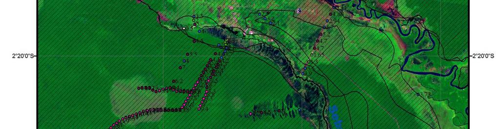
14 A. Comparison between (1)Measured Peat Depth Points (2) Wetlands International Map (2004) (3) Landsat ETM (2000/07/16) ( Area) 14


15 Close up in next slide 15
16 Comparison of Peat Depth between Measured Depth and Wetlands International Map (2004) Depth Code Measured Peat Depth Wetlands International 0-1 m m m m m Comparison of Peat Depth Measured Peat Depth Wetlands International (2004) Sampling Point ID Measured Peat Depth Wetlands International (2004) (True:0, False:1) Code Depth m m m m m Number of Different Peat Depth (41%): Total Number of Sampling Point: sampling points Remarks: 1.42 sampling points show different depth between measured depth and Wetlands International Map (2004) 1-2 m (WI) 0-1 m (WI) (Measured depth: 4.2m) Measured depth: 3.1m (Original Data from Dr.Shimada) 8-12 m (WI) 4-8 m (WI) B. Comparison between (1) Measured Peat Depth Points (2) Wetlands International Map (2004) (3) Landsat ETM (2000/07/16) (4) Moratorium Peatland Map ( Area) 16


17 17

No Information area -No information in WI Map.")
 (1)Under estimate area (Peat Depth was confirmed)")


18 (2)Over estimate area -No information in WI Map - City is mainly located on sandstone instead of peatland. Because it is impossible to develop urban area on un-stable geological settings. (3)No Information area -No information in WI Map. But peat distribution is strongly suggested such as area of upper stream (Under estimate area) (1)Under estimate area (Peat Depth was confirmed) (2)Over estimate area -No information in WI Map - City is mainly located on sandstone instead of peatland. Because it is impossible to develop urban area on un-stable geological settings. (3)No Information area -No information in WI Map. But peat distribution is strongly suggested such as area of upper stream (Under estimate area) (1)Under estimate area (Peat Depth was confirmed) 18
 (3) Landsat ETM (2000/07/16) (3) Moratorium Peatland")
 HEF 3400ha 2200ha 1700ha")
19 C. Comparison between (1) Wetlands International Map (2004) (2) ASTER(2011/06/13) (3) Landsat ETM (2000/07/16) (3) Moratorium Peatland Map (Palm Oil Area in Kapuas) Total 7300ha land was developed during 2009/07/ /07/17 (Larger than City) HEF 3400ha 2200ha 1700ha Palangka Raya City 19


20 3200ha 2200ha 1800ha 3200ha 2200ha 1800ha 20
Over estimate area")
 (2)Over")


21 2012/4/17 (2)Over estimate area -No information in WI Map (2)Over estimate area -No information in WI Map (1)Under estimate area (Peat Depth was confirmed) (2)Over estimate area + (3)No information area -No information in WI Map - Palm Oil area developed during (2)Over estimate area -No information in WI Map (2)Over estimate area -No information in WI Map (1)Under estimate area (Peat Depth was confirmed) (2)Over estimate area + (3)No information area -No information in WI Map - Palm Oil area developed during


22 Land Cover Changes in Peatland of Kalteng 2nd Round Technical Discussion on Peatland Mapping Hotel Akmani, 13th September 2011 Mitsuru Osaki Research Faculty of Agriculture, Hokkaido University Keiji Kimura Information Science and Technology, Hokkaido University Kazuyo Hirose Center for Sustainability Science, Hokkaido University 1 Bare land 1.Unclassified 2.Bare land 3.Sparse grass 2001/06/ /08/05 4.Water 5.Muddy soil 6.Dense grass 2 7.Marsh 8.Sparse forest 9.Dense forest 2001/06/ /08/05 Bare land + Sparse grass km Land Cover Change between 2001/06/09 and 2007/08/05 by Landsat ETM in Central Kalimantan 22

 Sparse forest (NDWI<-0.2, NDVI>0.")
23 1.Unclassified 2.Bare land 3.Sparse grass 4.Water 5.Muddy soil 6.Dense grass 7.Marsh 8.Sparse forest 9.Dense forest 2001/06/ /08/05 Area(ha) 2001(a) 2007(b) (b)/(a)% 1.Unclassified % 2.Bare land % 3.Sparse grass % 4.Dense grass % 5.Muddy soil % 6.Marsh % 7.Water % 8.Sparse forest % 9.Dense forest % Total Area (ha) Bare land/dense forest (%) 3% 16% 1) Dense forest (NDWI>-0.2, NDVI>0.3) Sparse forest (NDWI<-0.2, NDVI>0.3) 2) ISO Classification was applied with NDVI, NDWI and NDSI km Land Cover Change between 2001/06/09 and 2007/08/05 by Landsat ETM in Central Kalimantan 23
Fundamental of Peatland Mapping Consultation Meeting for Indonesian Climate Change Center (ICCC)
") Fundamental of Peatland Mapping Consultation Meeting for Indonesian Climate Change Center (ICCC) DNPI, 15th August 2011 Mitsuru Osaki Research Faculty of Agriculture, Hokkaido University Kazuyo Hirose
Fundamental of Peatland Mapping Consultation Meeting for Indonesian Climate Change Center (ICCC) DNPI, 15th August 2011 Mitsuru Osaki Research Faculty of Agriculture, Hokkaido University Kazuyo Hirose
Summary of Terminal Evaluation
 I. Outline of the Project Country: Indonesia Issue/Sector: Environment and Energy Division in charge: Global Environment Dept. Forestry and Nature Conservation Division 1 Period of (R/D): Dec.2009 to Mar.
Strategies for implementing sustainable management of peatlands in Borneo
 Strategies for implementing sustainable management of peatlands in Borneo Status reports, identification of knowledge gaps and priority rating of knowledge gaps as presented and discussed during the STRAPEAT
Characterizing the cultivated lowland peat soils in two physiography positions in Kalimantan, Indonesia
 International Research Journal of Agricultural Science and Soil Science (ISSN: 2251-0044) Vol. 3(7) pp. 246-255, July, 2013 Available online http://www.interesjournals.org/irjas Copyright 2013 International
Extended abstract No. 176 SUBSIDENCE IN DRAINED COASTAL PEATLANDS IN SE ASIA: IMPLICATIONS FOR SUSTAINABILITY
 Extended abstract No. 176 SUBSIDENCE IN DRAINED COASTAL PEATLANDS IN SE ASIA: IMPLICATIONS FOR SUSTAINABILITY A. Hooijer 1, B. Triadi 2, O. Karyanto 3, S.E. Page 4, M. van der Vat 1 and G. Erkens 1 ( 1
Indonesia Burning The Impact of Fire on Tropical Peatlands : Focus on Central Kalimantan
 Indonesia Burning The Impact of Fire on Tropical Peatlands : Focus on Central Kalimantan A collaborative research programme: *Sue Page, Univ. of Leicester, UK *Jack Rieley, Univ. of Nottingham, UK *Florian
LEDS Cooperation: Indonesia s Perspective
 LEDS Cooperation: Indonesia s Perspective Farhan Helmy Secretary of Mitigation Working Group National Council on Climate Change -Indonesia (DNPI) Bonn, 18 May 2012 Indonesia's View on Future Cooperation
Wahyunto, Ai Dariah and Fahmuddin Agus. Soil Research Institute INDONESIAN MINISTRY OF AGRICULTURE
 DISTRIBUTION, PROPERTIES, AND CARBON STOCK OF INDONESIAN PEATLAND Wahyunto, Ai Dariah and Fahmuddin Agus Wahyunto_wt@yahoo.co.id Center for Agricultural Land Resources Research and Development Center for
Ecosystem modelling of tropical wetlands
 University of New Hampshire University of New Hampshire Scholars' Repository Earth Sciences Scholarship Earth Sciences 2012 Ecosystem modelling of tropical wetlands Kristell Hergoualc h CIFOR Steve Frolking
Ameliorant Application on Variation of Carbon Stock and Ash Content on Peatland South Kalimantan
 Available online at: http://journal.unila.ac.id/index.php/tropicalsoil J Trop Soils, Vol. 18, No. 1, 213: 11-16 DOI: 1.54/jts.212.18.1.11 Ameliorant Application on Variation of Carbon Stock and Ash Content
WHY INDONESIA'S FORESTRY SECTOR IS NOT SUSTAINABLE July 25 th 2014 CONFERENCE PRESENTATION
 WHY INDONESIA'S FORESTRY SECTOR IS NOT SUSTAINABLE July 25 th 2014 CONFERENCE PRESENTATION CONTENTS State of Indonesian Forests Challenges Opportunities and key enablers STATE OF INDONESIAN FOREST INDONESIA
FORMA: Forest Monitoring for Action
 FORMA: Forest Monitoring for Action FORMA uses freely-available satellite data to generate rapidly-updated online maps of tropical forest clearing. We have designed it to provide useful information for
HUMAN RESOURCES AND EDUCATIONAL INFRASTRUCTURE
 University of Palangka Raya HUMAN RESOURCES AND EDUCATIONAL INFRASTRUCTURE Human Resources The number of academic staff in UNPAR until 2003 is 640, consists of 399 undergraduates, 221 masters and 20 doctors.
Peatland degradation fuels climate change
 Peatland degradation fuels climate change Peatland degradation fuels climate change An unrecognised and alarming source of greenhouse gases November 2006. Government representatives from almost all countries
PeatRus project. Restoring Peatlands in Russia - for fire prevention and climate change mitigation
 PeatRus project Restoring Peatlands in Russia - for fire prevention and climate change mitigation Forest-peat fires 2010 9 August, 2010 Moscow, August 01, 2010 +36 C Gaps Inventory of peatlands Satellite
15 th International Peat Congress in Sarawak, Malaysia Is Peatland Utilization the Main Cause of Land Fire in Indonesia?.
 15 th International Peat Congress in Sarawak, Malaysia www.ipc2016.com Is Peatland Utilization the Main Cause of Land Fire in Indonesia?. Moch. Riza Kasfari*), Yudha Asmara Adhi, Basuki Somawinata and
Pontianak, October 1-2, 2013
 Workshop for Climate Change Mitigation Through the Cooperation between Ministry of Forestry, Provincial Government of West Kalimantan, and Japan International Cooperation Agency Pontianak, October 1-2,
Planning hydrological restoration of peatlands in Indonesia to mitigate carbon dioxide emissions
 Planning hydrological restoration of peatlands in Indonesia to mitigate carbon dioxide emissions Sebangau National Park, Central Kalimantan, Indonesia Julia Jaenicke, Henk Wösten, Arif Budiman & Florian
Effect of Canal Damming on the Surface Water Level Stability in the Tropical Peatland Area
 Effect of Canal Damming on the Surface Water Level Stability in the Tropical Peatland Area Gatot Eko SUSILO*, **, Koichi YAMAMOTO*, Tsuyoshi IMAI*, Takashi INOUE***, Hidenori TAKAHASHI****, Yoshiyuki ISHII*****,
REMOTE SENSING POTENTIALS TO ESTIMATE FOREST CARBON STOCKS IN INDONESIA & NEPAL IN THE CONTEXT OF REDD+
 REMOTE SENSING POTENTIALS TO ESTIMATE FOREST CARBON STOCKS IN INDONESIA & NEPAL IN THE CONTEXT OF REDD+ By Eva Achmad 1, Utsab Thapa 2 1 Graduate School of Bogor Agricultural University, Indonesia and
Spatiotemporal distribution of peatland fires in Kapuas District, Central Kalimantan Province, Indonesia
 Agriculture, Forestry and Fisheries 2014; 3(3): 163-170 Published online May 30, 2014 (http://www.sciencepublishinggroup.com/j/aff) doi: 10.11648/j.aff.20140303.14 Spatiotemporal distribution of peatland
Modelling and Simulation
 Modelling and Simulation AFITA 2010 International Conference, The Quality Information for Competitive Agricultural Based Production System and Commerce Simulating Bioethanol Production from Sago Palm Grown
INDONESIAN WETLANDS MANAGEMENT POLICY
 INDONESIAN WETLANDS MANAGEMENT POLICY by : Ir. Sonny Partono. MM Director of Directorate of Conservation Area and Protected Forest Management, Directorate of Forest Protection and Nature Conservation Ministry
Terms of Reference (TOR)
") Terms of Reference (TOR) Document No.1 2017/10/01 1st Tropical Peatland Roundtable -Establishing "International Committee for Technical-Advice on Tropical Peatland-Restoration Action in Indonesia (ICPRA)"-
Terms of Reference (TOR) Document No.1 2017/10/01 1st Tropical Peatland Roundtable -Establishing "International Committee for Technical-Advice on Tropical Peatland-Restoration Action in Indonesia (ICPRA)"-
Impact of Land Use Change on Carbon Stock and GHG Emissions in New Oil Palm Plantings - Case Studies from Musim Mas Group -
 Impact of Land Use Change on Carbon Stock and GHG Emissions in New Oil Palm Plantings - Case Studies from Musim Mas Group - By Dr Gan Lian Tiong, Musim Mas Group Head of Sustainability Introduction Over
FIRE IMPACTS AND CARBON RELEASE ON TROPICAL PEATLANDS IN CENTRAL KALIMANTAN, INDONESIA
 Abstract FIRE IMPACTS AND CARBON RELEASE ON TROPICAL PEATLANDS IN CENTRAL KALIMANTAN, INDONESIA Boehm, H.-D.V. (1), Siegert, F. (1,2), Rieley, J.O. (3), Page, S.E. (4), Jauhiainen, J. (5), Vasander, H.
Promoting JCM scheme in Indonesia. Dicky Edwin Hindarto Head of Indonesia JCM Secretariat
 Promoting JCM scheme in Indonesia Dicky Edwin Hindarto Head of Indonesia JCM Secretariat All stakeholders work together to promote JCM 2 22 6 2 108 3 3 Some challenges on Indonesia JCM implementation Reliability
LAND USE PLANNING FOR MAMMINASATA METROPOLITAN WATER AVAILABILITY, SOUTH SULAWESI, INDONESIA
 LAND USE PLANNING FOR MAMMINASATA METROPOLITAN WATER AVAILABILITY, SOUTH SULAWESI, INDONESIA Roland Alexander Barkey 1, Muh. Faisal M. 2 1 Research & Development Center for Natural Heritage, Biodiversity
Monitoring Deforestation and Forest Degradation on National and Local Level in Indonesia
 Monitoring Deforestation and Forest Degradation on National and Local Level in Indonesia Dr. Ir. Ruandha A. Sugardiman, M.Sc. Dr. Ir. Belinda A. Margono, M.Sc. Ministry of Environment and Forestry Indonesia
Greenhouse Gas (GHG) Status on Land Use Change and Forestry Sector in Myanmar
 Status on Land Use Change and Forestry Sector in Myanmar") Greenhouse Gas (GHG) Status on Land Use Change and Forestry Sector in Myanmar CHO CHO WIN ASSISTANT RESEARCH OFFICER FOREST RESEARCH INSTITUTE YEZIN, MYANMAR International Workshop on Air Quality in Asia-Impacts
Greenhouse Gas (GHG) Status on Land Use Change and Forestry Sector in Myanmar CHO CHO WIN ASSISTANT RESEARCH OFFICER FOREST RESEARCH INSTITUTE YEZIN, MYANMAR International Workshop on Air Quality in Asia-Impacts
Development of National GHG Inventory: INDONESIA
 Development of National GHG Inventory: INDONESIA Rizaldi Boer (Bogor Agricultural University) E-mail: rboer@fmipa.ipb.ac.id Gunardi (Ministry of Environment) E-mail: gunardi@menlh.go.id Outline of Presentation
Taking New Tropical Peat Fire Evaluation Methods Nation-wide In Indonesia
 Taking New Tropical Peat Fire Evaluation Methods Nation-wide In Indonesia Laura Graham, Grahame Applegate, Andri Thomas, Erianto Indra Putra, Kevin Ryan and Mark Cochrane part of the NASA-funded SDSU-IPB
Distribution, Properties, and Carbon Stock of Indonesian Peatland
 H Distribution, Properties, and Carbon Stock of Indonesian Peatland 1) Wahyunto 1), Ai Dariah 2) and Fahmuddin Agus 2) Indonesian Center for Agricultural land Research and Development, Ministry of Agriculture,
Recent Progress of Air Pollution Modelling for co-benefit estimation
 Kyoto University 1 21 st AIM International Workshop 13 th 15 th November, 2015 NIES, Tsukuba, JAPAN Recent Progress of Air Pollution Modelling for co-benefit estimation Gakuji KURATA Kyoto University Kyoto
INDONESIA S POLICIES ON CLIMATE CHANGE AND 1 ST BUR PROGRESS: Reshaping Current Condition to Win the Future
 INDONESIA S POLICIES ON CLIMATE CHANGE AND 1 ST BUR PROGRESS: Reshaping Current Condition to Win the Future Dr. Etti Ginoga Directorate of GHG Inventory and MRV, Directorate General Of Climate Change,
Emission Reduction Program in Indonesia: A District-wide Approach to REDD+
 Emission Reduction Program in Indonesia: A District-wide Approach to REDD+ Agus Sari Chair, Working Group on Funding Instruments Presidential Task Force on REDD+ Paris,France, June 23, 2013 WWF-Indonesia
Chapter 6 Oil-palm estate development in Southeast Asia: consequences for peat swamp forests and livelihoods in Indonesia
 81 Chapter 6 Oil-palm estate development in Southeast Asia: consequences for peat swamp forests and livelihoods in Indonesia In this chapter, the DPSIR analysis is applied to oil-palm development in the
PEATLAND RESTORATION in Indonesia
 PEATLAND RESTORATION in Indonesia Dr. Myrna A. Safitri Deputy of Education, Socialization, Participation and Partnership Presentation at Japan Pavilion of COP 22, Marrakech November 11, 2016 Indonesian
MINISTRY of FORESTRY. IPB International Convention Center (IICC) Bogor - 27 June 2012
 Bogor - 27 June 2012") MINISTRY of FORESTRY IPB International Convention Center (IICC) Bogor - 27 June 2012 Indonesian forest: based on function and coverage Chronology of Forestry Law Utilization of Forest Area National Forestry
MINISTRY of FORESTRY IPB International Convention Center (IICC) Bogor - 27 June 2012 Indonesian forest: based on function and coverage Chronology of Forestry Law Utilization of Forest Area National Forestry
Wetland Management Session
 2 nd International Seminar UNFCCC On Cutting Workshop Edge on Science & Technologies technical towards and Food, scientific Environment aspects of ecosystems and Health with - Focus: high-carbon Civil
Primary and secondary settlements in normally consolidated organic soils
 n d International Conference on New Developments in Soil Mechanics and Geotechnical Engineering, 8-30 May 009, Near East University, Nicosia, North Cyprus Primary and secondary settlements in normally
Mitigation Policies and MRV system in Indonesia: Challenges and Opportunities
 Mitigation Policies and MRV system in Indonesia: Challenges and Opportunities Rizaldi Boer Centre for Climate Risk and Opportunity Management in South East Asia and Pacific, Bogor Agriculture University
Current Status of Climate Change Mitigation and Adaptation
 Current Status of Climate Change Mitigation and Adaptation Indonesia National Council on Climate Change Bangkok,19 August 2011 Overview of climate change mitigation and 1. Current adaptation status and
Title. Author(s) Yulianti, Nina; Hayasaka, Hiroshi; Usup, Aswin. Citation Global environmental research, 16(1):
 Yulianti, Nina; Hayasaka, Hiroshi; Usup, Aswin. Citation Global environmental research, 16(1):") Title Recent Forest and Peat Fire Trends in Indonesi The Latest Decade by MODIS Hotspot Data Author(s) Yulianti, Nina; Hayasaka, Hiroshi; Usup, Aswin Citation Global environmental research, 16(1): 105-116
Title Recent Forest and Peat Fire Trends in Indonesi The Latest Decade by MODIS Hotspot Data Author(s) Yulianti, Nina; Hayasaka, Hiroshi; Usup, Aswin Citation Global environmental research, 16(1): 105-116
Drainage and land use impacts on changes in selected peat properties and peat degradation in West Kalimantan Province, Indonesia
 Biogeosciences, 7, 3403 3419, 2010 doi:10.5194/bg-7-3403-2010 Author(s) 2010. CC Attribution 3.0 License. Biogeosciences Drainage and land use impacts on changes in selected peat properties and peat degradation
Land Accounts in Indonesia
 Land Accounts in Indonesia outline! Background! Land Accounts in Indonesia! Technical issues faced and resolutions Consideration Background Government Regulation on Environmental Economic Instruments (PP
Standard Methods for Estimating Greenhouse Gas Emissions from Forests and Peatlands in Indonesia
 Standard Methods for Estimating Greenhouse Gas Emissions from Forests and Peatlands in Indonesia (Version 2) Chapter 4: Standard Method Forest Management Events and Regimes MINISTRY OF ENVIRONMENT AND
INTRODUCTION cont. INTRODUCTION. What is Impervious Surface? Implication of Impervious Surface
 Mapping Impervious Surface Changes In Watersheds In Part Of South Eastern Region Of Nigeria Using Landsat Data By F. I. Okeke Department of Geoinformatics and Surveying, University of Nigeria, Enugu Campus
THE ROLE OF PUBLIC-PRIVATE COOPERATION FOR THE CONSERVATION AND RESTORATION OF FOREST ECOSYSTEM
 THE ROLE OF PUBLIC-PRIVATE COOPERATION FOR THE CONSERVATION AND RESTORATION OF FOREST ECOSYSTEM by: HERRY SUBAGIADI Director of Conservation Area, Ministry of Environment and Forestry, RI. INDONESIAN FORESTS
National Forest Monitoring System Development in Cambodia
 National Forest Monitoring System Development in Cambodia 5 th UN-REDD Regional Lesson Learn Workshop Forest Monitoring System and Reference Levels for REDD+ Hanoi, Vietnam, 20-22 October, 2014 Presented
Commodity Booms and Green Growth in Indonesia. Budy P. Resosudarmo Australian National University
 Commodity Booms and Green Growth in Indonesia Budy P. Resosudarmo Australian National University Index of production 2 Commodity boom: Coal and palm oil 450 400 Palm oil 350 300 Coal 250 200 150 100 50
Indonesia s Experiences in Developing of Time Series Estimates and Projections (Inluding Evaluation of Impacts of Policies and Measures)
") Indonesia s Experiences in Developing of Time Series Estimates and Projections (Inluding Evaluation of Impacts of Policies and Measures) Tsukuba Japan 16 18 July 2008 OUTLINE 1. Practical aspects of uncertainty
Indonesia s Experiences in Developing of Time Series Estimates and Projections (Inluding Evaluation of Impacts of Policies and Measures) Tsukuba Japan 16 18 July 2008 OUTLINE 1. Practical aspects of uncertainty
LOW EMISSION DEVELOPMENT STRATEGIES: LINKING TO SUB- NATIONAL PLANS
 LOW EMISSION DEVELOPMENT STRATEGIES: LINKING TO SUB- NATIONAL PLANS JULY 3, 2012 TODD JOHNSON FOREST CARBON ADVISOR LOW EMISSIONS ASIAN DEVELOPMENT (LEAD) PRESENTATION OUTLINE What are Low Emission Development
Indonesian Forest Resource Monitoring
 Indonesian Forest Resource Monitoring Belinda Arunarwati Margono Jakarta, 12 November 2014 Aketajawe-lolobata - Maluku From global data set.. to national http://earthenginepartners.appspot.com/science-2013-global-forest
GLOBAL SOIL ORGANIC CARBON. Map 1.0 VERSION
 2017 GLOBAL ORGANIC CARBON Map 1.0 VERSION Soil organic carbon (SOC) is the carbon that remains in the soil after partial decomposition of any material produced by living organisms. It constitutes a key
Finnish national strategy for the sustainable and responsible use of mires and peatlands background goals affects
 Finnish national strategy for the sustainable and responsible use of mires and peatlands background goals affects Samu Valpola Geological Survey of Finland Western Finland Office Kokkola 17.10.2013 1 Peat
STATEMENT. Issued by participants of the. International Symposium, Workshop and Seminar on Tropical Peatland, Yogyakarta, Indonesia, August 2007
 STATEMENT Issued by participants of the International Symposium, Workshop and Seminar on Tropical Peatland, Yogyakarta, Indonesia, 27-31 August 2007 Carbon - Climate - Human Interactions - Carbon Pools,
Available online at ScienceDirect. Procedia Environmental Sciences 33 (2016 ) Suria Darma Tarigan*
 Suria Darma Tarigan*") Available online at www.sciencedirect.com ScienceDirect Procedia Environmental Sciences 33 (2016 ) 386 392 The 2 nd International Symposium on LAPAN-IPB Satellite for Food Security and Environmental Monitoring
Available online at www.sciencedirect.com ScienceDirect Procedia Environmental Sciences 33 (2016 ) 386 392 The 2 nd International Symposium on LAPAN-IPB Satellite for Food Security and Environmental Monitoring
INDONESIA: UN-REDD PROGRESS Jakarta, September 14, 2009
 INDONESIA: UN-REDD PROGRESS 2009 DIRECTORATE GENERAL OF FOREST PLANNING MINISTRY OF FORESTRY Jakarta, September 14, 2009 PROGRESS National Climate Change Council Forestry Climate Change Working Group Demonstration
Carbon Stocks and Emissions of Malaysian Forests
 Carbon Stocks and Emissions of Malaysian Forests Abd Latif M., Ismail H., & Elizabeth P. Forest Research Institute Malaysia 52109 Kepong, Selangor, Malaysia ISO 9001 : 2008 www.frim.gov.my Content Background
Introduction of the JOGMEC survey and brief overview on the laws and regulations of coal mining in Indonesia. Eiichiro Nakama
 JOGMEC Survey on Environmental Protection, Forest Conservation, Land Reclamation and Forest Rehabilitation in Coal Mining in Indonesia Introduction of the JOGMEC survey and brief overview on the laws and
Assessment and mapping of GRASSLAND ecosystems condition and their services in Bulgaria, Contr. Д-33-90/
 1 General typology of grassland ecosystems We consider Grassland ecosystem as a natural or seminatural vegetation type. It could be part of farm holdings like pastures, meadows, uncultivated lands, etc.
Linkages of JCM with NAMAs, MRV and Registry: An Update
 Linkages of JCM with NAMAs, MRV and Registry: An Update Farhan Helmy Secretary of Mitigation Working Group, DNPI Warsawa, 18 November 2013 1 Outline The Need for Unified RegistrySystem Road to NAMAs: Four
2015 PNG Update 19 th June, 2015 UPNG (SLT), Parallel Session 4 Land and Forests
, Parallel Session 4 Land and Forests") 2015 PNG Update 19 th June, 2015 UPNG (SLT), Parallel Session 4 Land and Forests Balancing Economic Growth and Natural Resource Management when Emissions Count: Experiences in the Forestry & Land Use Sector
2015 PNG Update 19 th June, 2015 UPNG (SLT), Parallel Session 4 Land and Forests Balancing Economic Growth and Natural Resource Management when Emissions Count: Experiences in the Forestry & Land Use Sector
Fahmuddin Agus Indonesian Soil Research Institute Jl. Tentara Pelajar, No. 12, Cimanggu, Bogor 16114, Indonesia
 Fahmuddin Agus Indonesian Soil Research Institute Jl. Tentara Pelajar, No. 12, Cimanggu, Bogor 16114, Indonesia f_agus@litbang.pertanian.go.id MARCO Symposium 2015 Tsukuba International Congress Center,
Trajectory and Concentration PM 10. on Forest and Vegetation Peat-Fire HYSPLIT Model Outputs and Observations (Period: September October 2015)
") IOP Conference Series: Earth and Environmental Science PAPER OPEN ACCESS Trajectory and Concentration PM 10 on Forest and Vegetation Peat-Fire HYSPLIT Model Outputs and Observations (Period: September
IOP Conference Series: Earth and Environmental Science PAPER OPEN ACCESS Trajectory and Concentration PM 10 on Forest and Vegetation Peat-Fire HYSPLIT Model Outputs and Observations (Period: September
CURRENT ISSUES OF TROPICAL PEATLAND IN INDONESIA
 CURRENT ISSUES OF TROPICAL PEATLAND IN INDONESIA Basuki Sumawinata and Darrnawan Department of Soil Science and Land Resources, Faculty ofagriculture, Bogor Agricultural University Email: basukis2@yahoo.com
MRV for REDD: Indonesia experience
 MRV for REDD: Indonesia experience Doddy Sukadri Indonesia National Council on Climate Change Prepared for The workshop on REDD-plus After Cancun: Moving from Negotiation to Implementation Organized by
FREL and REDD+ in Indonesia
 FREL and REDD+ in Indonesia Ms. Novia Widyaningtyas Head of REDD+ Division Directorate of Climate Change Mitigation Directorate General of Climate Change Ministry of Environment and Forestry - Republic
Land use, spatial planning, and potential implications for REDD+ in Indonesia: A preliminary analysis
 Land use, spatial planning, and potential implications for REDD+ in Indonesia: A preliminary analysis Ida Aju Pradnja Resosudarmo Pekanbaru, May 11, 2012 Context-1: the Forest Area 187 MHa land area 93
HOW CAN INDONESIA ACHIEVE ITS CLIMATE CHANGE MITIGATION GOAL? AN ANALYSIS OF POTENTIAL EMISSIONS REDUCTIONS FROM ENERGY AND LAND-USE POLICIES
 WORKING PAPER HOW CAN INDONESIA ACHIEVE ITS CLIMATE CHANGE MITIGATION GOAL? AN ANALYSIS OF POTENTIAL EMISSIONS REDUCTIONS FROM ENERGY AND LAND-USE POLICIES ARIEF WIJAYA, HANNY CHRYSOLITE, MENGPIN GE, CLORINDA
Role of IPRs in the Diffusion and Transfer of Technologies, including Lesson from Work in the Trips Council
 Role of IPRs in the Diffusion and Transfer of Technologies, including Lesson from Work in the Trips Council Widiatmini Sih Winanti Secretary of Transfer Technology Working Group National Council on Climate
Carbon dioxide emissions from forestry and peat land using landuse/land-cover changes in North Sumatra, Indonesia
 IOP Conference Series: Earth and Environmental Science PAPER OPEN ACCESS Carbon dioxide emissions from forestry and peat land using landuse/land-cover changes in North Sumatra, Indonesia To cite this article:
REQUIRED DOCUMENT FROM HIRING UNIT
 Terms of reference GENERAL INFORMATION Title: Management Specialist Project Name : REDD+ Reports to: Duty Station: Jakarta Expected Places of Travel: Riau, Jambi, South Sumatera, Central Kalimantan, West
NAMAs & MRV Update : INDONESIA. Farhan Helmy Secretary of Mitigation Working Group National Council on Climate Change -Indonesia (DNPI)
") NAMAs & MRV Update : INDONESIA Farhan Helmy Secretary of Mitigation Working Group National Council on Climate Change -Indonesia (DNPI) 1 st Autumn School, 15-23 October 2012 INDONESIA NAMAs: Submission:
NAMAs & MRV Update : INDONESIA Farhan Helmy Secretary of Mitigation Working Group National Council on Climate Change -Indonesia (DNPI) 1 st Autumn School, 15-23 October 2012 INDONESIA NAMAs: Submission:
International Union for Conservation of Nature. Conserving biodiversity Pioneering nature s solutions to global challenges
 International Union for Conservation of Nature Conserving biodiversity Pioneering nature s solutions to global challenges WHO WE ARE Founded in 1948, IUCN is the world s largest global environmental organization.
Landsat 5 & 7 Band Combinations
 Landsat 5 & 7 Band Combinations By James W. Quinn Landsat 5 (TM sensor) Wavelength (micrometers) Resolution (meters) Band 1 0.45-0.52 30 Band 2 0.52-0.60
Soil nitrogen supply and nitrogen uptake for local rice grown in unfertilized acid sulfate soil in South Kalimantan
 TROPICS Vol. ( ) Issued September, Soil nitrogen supply and nitrogen uptake for local rice grown in unfertilized acid sulfate soil in South Kalimantan Erry PURNOMO 1, Toshihiro HASEGAWA 2,3, Yasuyuki HASHIDOKO
FACILITATIVE SHARING OF VIEWS MALAYSIA 15 MAY 2017
 FACILITATIVE SHARING OF VIEWS MALAYSIA 15 MAY 2017 NATIONAL CIRCUMSTANCES IN 2011 CONSTRUCTION 3% MINING AND QUARRYING 9% GDP RM711,800 million (USD 233,300 million) (constant 2005 prices) SERVICES 55%
REQUIRED DOCUMENT FROM HIRING UNIT
 Terms of reference GENERAL INFORMATION Title: Provincial Field Dinamisator (Jambi) Project Name: Support Facility for BRG (Badan Restorasi Gambut) Institutional Set-Up Reports to: Deputy III of BRG and
ENVIRONMENTAL AND SOCIAL IMPACTS OF OIL PALM CULTIVATION ON TROPICAL PEAT
 Environmental and social impacts of oil palm cultivation on tropical peat a scientific review ENVIRONMENTAL AND SOCIAL IMPACTS OF OIL PALM CULTIVATION ON TROPICAL PEAT A SCIENTIFIC REVIEW Arina P. Schrier-Uijl
RSPO NOTIFICATION OF PROPOSED NEW PLANTING
 RSPO NOTIFICATION OF PROPOSED NEW PLANTING This notification shall be on the RSPO website for 30 days as required by the RSPO procedures for new plantings (http://www.rspo.org/?q=page/535). It has also
THE ASSESSMENT OF RAPID LANDUSE CHANGE AND ITS IMPACT ON SUSTAINABLE FISHERIES
 THE ASSESSMENT OF RAPID LANDUSE CHANGE AND ITS IMPACT ON SUSTAINABLE FISHERIES By: Dewayany Sutrisno National Coordination Agency For Survey And Mapping - Indonesia e-mail: dewayani@bakosurtanal.go.id
Innovating on Wide-ranged Ecology Research by Hyper-sensor
 Innovating on Wide-ranged Ecology Research by Hyper-sensor Evaluation of the High-Carbon Reservoirs: Tropical Peatland by Integrated MRV System Kazuyo Hirose *1, Tomomi Takeda *1, Seido Onishi *2, Osamu
PROJECT INFORMATION DOCUMENT (PID) IDENTIFICATION/CONCEPT STAGE Report No.: PIDC103763
 IDENTIFICATION/CONCEPT STAGE Report No.: PIDC103763") PROJECT INFORMA DOCUMENT (PID) IDENTIFICA/CONCEPT STAGE Report No: PIDC103763 Project Name Region Country Financing Instrument Project ID Borrower Name Implementing Agency Environmental Category Date PID
PROJECT INFORMA DOCUMENT (PID) IDENTIFICA/CONCEPT STAGE Report No: PIDC103763 Project Name Region Country Financing Instrument Project ID Borrower Name Implementing Agency Environmental Category Date PID
Capacity Building Activities in Indonesia and the Other NDs
 Capacity Building Activities in Indonesia and the Other NDs Toshi Kamei Remote Sensing Technology Center (RESTEC) 9 February 2012 GEO-FCT SDS3 Overview RESTEC (RESTEC) was established in 1975. The purposes
From the desert to the swamp: the role of reeds in the world of peatlands. Hans Joosten Greifswald University
 From the desert to the swamp: the role of reeds in the world of peatlands Hans Joosten Greifswald University Caspar David Friedrich: Meadows near Greifswald (~1821) Hans Joosten Me: Reedbeds near Greifswald
Development of Sub National FREL in West Kalimantan
 Development of Sub National FREL in West Kalimantan Hideyuki Kubo JICA Expert Indonesia Japan Project for Development of REDD+ Implementation Mechanism (IJ REDD+) 10 November 2016 Presentation 1. West
The Indonesian-Norway cooperation on REDD+ (Slow, Halt & Reverse deforestation) World Bank, Washington DC, January 19, 2011 Fred Stolle People and
 World Bank, Washington DC, January 19, 2011 Fred Stolle People and") The Indonesian-Norway cooperation on REDD+ (Slow, Halt & Reverse deforestation) World Bank, Washington DC, January 19, 2011 Fred Stolle People and Ecosystem Program WRI Main Messages Future of Indonesian
The Indonesian-Norway cooperation on REDD+ (Slow, Halt & Reverse deforestation) World Bank, Washington DC, January 19, 2011 Fred Stolle People and Ecosystem Program WRI Main Messages Future of Indonesian
Forest and Land Cover Monitoring by Remote Sensing Data Analysis
 Low Carbon Asia Research Network (LoCARNet) 3rd Annual Meeting Bogor, Indonesia November 24 26, 2014 Forest and Land Cover Monitoring by Remote Sensing Data Analysis Muhammad Ardiansyah Center for Climate
Major atmospheric emissions from peat fires in SEA during non-drought years: Evidence from the 2013 Sumatran fires David Gaveau
 SOCP/YEL Paul Hilton/SOCP/YEL Reuters Major atmospheric emissions from peat fires in SEA during non-drought years: Evidence from the 2013 Sumatran fires David Gaveau Salim MA, Hergoualc h K, Locatelli
Land Suitability and Farmer Perception on Maize Cultivation in Limboto Basin Gorontalo
 Bahtiar et al.: Land Suitability and Farmer Perception on Maize Cultivation in Limboto Basin Gorontalo Land Suitability and Farmer Perception on Maize Cultivation in Limboto Basin Gorontalo Bahtiar 2,
ASSESSING AND ENHANCING CAPACITY FOR GBEP SUSTAINABILITY INDICATOR EVALUATION IN INDONESIA
 DIRECTORATE GENERAL OF NEW RENEWABLE ENERGY AND ENERGY CONSERVATION MINISTRY OF ENERGY AND MINERAL RESOURCES REPUBLIC OF INDONESIA ASSESSING AND ENHANCING CAPACITY FOR GBEP SUSTAINABILITY INDICATOR EVALUATION
CDM-ITB Contributions to Disaster Mitigation in Indonesia
 CDM-ITB Contributions to Disaster Mitigation in Indonesia Krishna S Pribadi - CDM-ITB Asia Disaster Reduction Science and Technology Forum December 4 th, 2006 BPPT Building, Jakarta, Indonesia Presentation
Unit III Nutrients & Biomes
 Unit III Nutrients & Biomes Nutrient Cycles Carbon Cycle Based on CO 2 cycling from animals to plants during respiration and photosynthesis. Heavy deposits are stored in wetland soils, oceans, sedimentary
Local Rice Cultivars Grown on Tidal Swampland near Coastal Area in South Kalimantan
 Local Rice Cultivars Grown on Tidal Swampland near Coastal Area in South Kalimantan Erry Purnomo 1, Muhammad Lestio Setiawan 1, Nurmili Yuliani 1, Ery Atmaja 1, Muhammad Wahyuni 1, Ahmad Rizali Saidy 2
NAMAs and MRV MANNER. Ministry of Environment, Republic of Indonesia. July 2010
 NAMAs and MRV MANNER Ministry of Environment, Republic of Indonesia July 2010 1 Indonesia National GHG Inventory Table Summary for GHG Emission in 2000 (Giga gram) CO2 CO2 emission removal CH4 N2O PFC
The Transformative Role of Renewables in Southeast Asia. Asia Clean Energy Forum 2017, ADB, Manila Deep-dive session 6 June 2017
 The Transformative Role of Renewables in Southeast Asia Asia Clean Energy Forum 2017, ADB, Manila Deep-dive session 6 June 2017 Time Activity Moderated by the International Renewable Energy Agency (IRENA)
MALAYSIA. Soil Resource Management
 Paper presented in the Asian Soil Partnership Consultation Workshop on Sustainable Management and Protection of Soil Resources 12 14 th May 2015; Bangkok,Thailand MALAYSIA Soil Resource Management Presented