Montana Bureau of Mines and Geology Kevin Chandler Jon Reiten. AWRA October 6 th,2011
|
|
|
- Roy Singleton
- 6 years ago
- Views:
Transcription


1 Montana Bureau of Mines and Geology Kevin Chandler Jon Reiten AWRA October 6 th,2011
2 Funding for this modeling effort came from the RRG project Modeling Aquifer Response to Urban Sprawl, West Billings Area, Montana Sponsored by the Yellowstone Conservation District


3 Changes in The West Billings Area There was a 23% loss of irrigated lands between 1966 and 1999 (Olson and Reiten,2002) GWIC Wells in T1S R25E, West Billings Area Number of Recorded Wells


4 Goals for Modeling the West Billings Aquifers Models will be used to represent steady state aquifer conditions in 2000 and in Transient flow models will be used to model changes in aquifer conditions with changes in land use recharge between and Transient flow models will be used to predict possible aquifer conditions resulting from future land use changes.


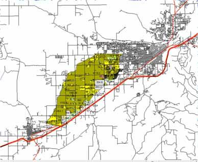
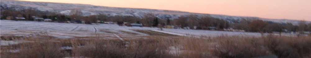
5 Modeled Area Billings N Laurel Billings Base Map, Montana NRIS
6 Terraces in West Billings Billings Terrace 3 Laurel Terrace 2 Terrace 1 From Olson and Reiten, 2002


7 Model Locations The three aquifer terraces, (Qa1,Qa2,and Qa3 (Gosling and Parshley, 1973; Lopez, 2000)) were split into two model areas. The Northern model includes the area from Big Ditch to BBWC, terrace 3, Qa3. The Southern model includes the area from BBWC to the Yellowstone River, terraces 1 and 2, Qa1 and Qa2.


8 Northern Model Boundary Grand Ave Central Billings Shilo Dr Neibauer 48th 64th 56th 80th 24th Laurel Airport Rd


9 Southern Model Boundary Hesper Neibauer 56th Shilo Dr 24th Danford 72nd


10 Well Used for Stratigraphy Modeling


11 Northern Model MODFLOW Grid Grand Ave Central Hesper 80th 24th


12 MODFLOW Grid Cell size 200 ft X 200 ft 43,506 active cells Surface area 20.8 mi² Vertical Magnification 20X

.")


13 Aquifer Properties The hydraulic conductivity of the terrace gravel aquifer was found to be in the ft/day range based on aquifer test results( Olson and Reiten, 2002). The hydraulic conductivity values in layer 2 of the model were varied using coverage polygons and were adjusted in the calibration process to values ranging from 50 to 200 ft/day. Specific yield values were initially set at 0.15 and were varied from to 0.10 during calibration to reflect the semi confining silty sand sediment cap which ranges from ft thick.


14 Recharge polygons for the Northern Model
15 Model calibration Model heads were calibrated using water level measurements collected monthly at 15 wells in the northern model area in and again in Surface water flow measurements on the major drains were used to calibrate drain flows from the model. Parameter estimation simulations (PEST) in GMS 7.0 were used during initial steady state model calibration. Hydrograph matching was used in transient model calibration.
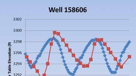


16 Hydrograph Matching for Transient Model Calibration


17 Calibration to Surface Water Flows


18 Calibration to Surface Water Flows


19 June June Jan This is an animation of a 32 month transient simulation with current land use conditions.


20 June June Jan This is an animation of the head differences between a transient simulation with field irrigation on and a simulation were recharge on fields is reduced to precipitation only. The ditches and canals remain on an provide recharge.


21 June June Jan This is an animation of the head differences between a transient simulation of current conditions and a simulation with all irrigation turned off including all ditches and canals.

22
23 Model Applications Model simulations were run to predict the impact of flood water retention ponds on aquifer conditions as part of the West Billings flood prevention study. Model simulations were used in the site selection for a community water supply well for Yellowstone Boys and Girls Ranch which was needed to replace their contaminated well.


24 Sharptail Floodwater Retention Pond Changes to Aquifer Heads


25 Yellowstone Boys and Girls Ranch Feedlot

26 Questions?
27 References Olson, J. L., & Reiten, J. C. (2002). Hydrogeology of the West Billings Area: Impacts of Land use Changes on Water Resources. Montana Tech, Montana Bureau of Mines and Geology. Butte Montana: MBMG. Anderson, M. P., & Woessner, W. W. (1992). Applied Groundwater Modeling, Simulation of Flow and Advective Transport. San Diego, California: Academic Press, Inc. Weight, W. D., & Sonderegger, J. L. (2001). Manual Of Applied Field Hydrology. New York: McGraw hill.
Numerical Groundwater Model for the Kaweah Delta Water Conservation District
 Numerical Groundwater Model for the Kaweah Delta Water Conservation District Nels Ruud and Peter Leffler Fugro West, Inc. Larry Dotson Kaweah Delta Water Conservation District Presentation Outline Background
NUMERICAL MODELING TO INVESTIGATE SAFE YIELD IN MAE SAI MULTILAYERED AQUIFERS
 NUMERICAL MODELING TO INVESTIGATE SAFE YIELD IN MAE SAI MULTILAYERED AQUIFERS Phatcharasak Arlai 1*, Sitisak Munyu 2, Kriangsak Pirarai 2 and Arun Lukjan 1 1 International Program of M.Eng in Water Resources
FAX
 21335 Signal Hill Plaza Suite 100 Sterling, Virginia 20164 www.geotransinc.com 703-444-7000 FAX 703-444-1685 Mr. William Kutash Florida Department of Environmental Protection Waste Management Division
Simulation of horizontal well performance using Visual MODFLOW
 Environ Earth Sci (2013) 68:1119 1126 DOI 10.1007/s12665-012-1813-x ORIGINAL ARTICLE Simulation of horizontal well performance using Visual MODFLOW Wan Mohd Zamri W. Ismail Ismail Yusoff Bahaa-eldin E.
4.4 MODEL CODE DESCRIPTION 4.5 WATER SOURCES AND SINKS 4.6 MODEL DOMAIN AND BOUNDARIES. SLR South Africa
 Page 4-18 The developed model should therefore be seen as an initial site model which should be refined and recalibrated once more groundwater monitoring and other data become available. 4.4 MODEL CODE
MODELING INVESTIGATION ON THE SUSTAINABLE GROUNDWATER YIELD FOR WIANG PA PAO AQUIFERS SYSTEM
 MODELING INVESTIGATION ON THE SUSTAINABLE GROUNDWATER YIELD FOR WIANG PA PAO AQUIFERS SYSTEM Phatcharasak Arlai 1*, Manfred Koch 2, Sitisak Munyu 3, Kriangsak Pirarai 3 and Arun Lukjan 1 1 Research Unit
The Permissible Yield in Mae Sai multilayered Aquifers System
 The Permissible Yield in Mae Sai multilayered Aquifers System Arlai, P. 1, Sitisak Manyu 2, Kriangsak Pirarai 2, Arun Lukjan 1 and Monthon Yongprawat 1 Abstract Chaingrai is an important province in the
Ground- Water in the Clark Fork Basin
 Well 19142: 6N 19W 7 BABC- Ravalli County Ground- Water in the Clark Fork Basin Tom Patton, John LaFave, and Larry Smith Montana Ground-Water Assessment September 27, 26 The Ground-Water Assessment Program
Montana Ground-Water Assessment Statewide Monitoring Well Network
 Montana Ground-Water Assessment Statewide Monitoring Well Network Montana Ground-Water Assessment Water-level Monitoring and Drought: January - March 2003 Tom Patton - Montana Bureau of Mines and Geology
Assessment of the Groundwater Quantity Resulting from Artificial Recharge by Ponds at Ban Nong Na, Phitsanulok Province, Thailand
 Research article erd Assessment of the Groundwater Quantity Resulting from Artificial Recharge by Ponds at Ban Nong Na, Phitsanulok Province, Thailand SIRIRAT UPPASIT* Faculty of Technology, Khon Kaen
GROUND WATER/SURFACE WATER INTERACTIONS AWRA SUMMER SPECIALTY CONFERENCE Judith Schenk'
 July 1-3 GROUND WATER/SURFACE WATER INTERACTIONS AWRA SUMMER SPECIALTY CONFERENCE 2002 326x6 pjf= INTEGRATION OF DATA USING GIS AND STATEPP TO ESTIMATE GROUNDWATER MODEL INPUT PARAMETERS Judith Schenk'
Response to DEQ Request for Additional Information for the Eagle Project Groundwater Discharge Permit Application
 Jonathan C. Cherry, P.E. Manager Environment and Governmental Affairs Kennecott Eagle Minerals Company 1004 Harbor Hill Drive Suite 103 Marquette, Michigan 49855 Phone: 906-225-5791 Email: Cherryj@Kennecott.com
CHAPTER 7 GROUNDWATER FLOW MODELING
 148 CHAPTER 7 GROUNDWATER FLOW MODELING 7.1 GENERAL In reality, it is not possible to see into the sub-surface and observe the geological structure and the groundwater flow processes. It is for this reason
Irrigation modeling in Prairie Ronde Township, Kalamazoo County. SW Michigan Water Resources Council meeting May 15, 2012
 Irrigation modeling in Prairie Ronde Township, Kalamazoo County SW Michigan Water Resources Council meeting May 15, 2012 Development of a Groundwater Flow Model INFLOWS Areal recharge from precipitation
3.2.3 Groundwater Simulation. (1) Purpose
 Purpose") The Study on Water Supply Systems in Mandalay City and in the Central Dry Zone Part II Study for Mandalay City 3.2.3 Groundwater Simulation (1) Purpose Because the Central Dry Zone, Myanmar, including
The Study on Water Supply Systems in Mandalay City and in the Central Dry Zone Part II Study for Mandalay City 3.2.3 Groundwater Simulation (1) Purpose Because the Central Dry Zone, Myanmar, including
A groundwater flow model for water related damages on historic monuments Case study West Luxor, Egypt
 VATTEN 65:247 254. Lund 2009 A groundwater flow model for water related damages on historic monuments Case study West Luxor, Egypt by Edgar Herbas Campos, Augustenborgsgatan 15 C, 214 47, Malmö, Sweden
Appendix I. Groundwater Modeling
 Appendix I. Groundwater Modeling This appendix describes current and future groundwater modeling efforts associated with the. 0 I. Current Objectives of Groundwater Modeling Efforts The objectives of groundwater
Montana Ground-Water Assessment Statewide Monitoring Well Network
 Montana Ground-Water Assessment Statewide Monitoring Well Network Montana Ground-Water Assessment Water-level Monitoring and Drought: July-September 2002 Tom Patton - Montana Bureau of Mines and Geology
Over 150 Years of Irrigation Implications for Montana s Water Resources
 Over 150 Years of Irrigation Implications for Montana s Water Resources Alters hydrographs Water storage; recharge Changes timing of flow Ginette Abdo Montana Bureau of Mines and Geology March 10, 2016
San Mateo Plain Groundwater Basin Assessment Stakeholder Workshop #8 17 APRIL 2018
 San Mateo Plain Groundwater Basin Assessment Stakeholder Workshop #8 17 APRIL 2018 PRESENTATION OVERVIEW Introductions Project Overview Summary of Analysis Supporting Model Development Model Development
Standard Guide for Conducting a Sensitivity Analysis for a Ground-Water Flow Model Application 1
 Designation: D 5611 94 (Reapproved 2002) Standard Guide for Conducting a Sensitivity Analysis for a Ground-Water Flow Model Application 1 This standard is issued under the fixed designation D 5611; the
Effect of Conjunctive Use of Water for Paddy Field Irrigation on Groundwater Budget in an Alluvial Fan ABSTRACT
 1 Effect of Conjunctive Use of Water for Paddy Field Irrigation on Groundwater Budget in an Alluvial Fan Ali M. Elhassan (1), A. Goto (2), M. Mizutani (2) (1) New Mexico Interstate Stream Commission, P.
AQUIFER STORAGE AND RECOVERY EVALUATION REPORT
 AQUIFER STORAGE AND RECOVERY EVALUATION REPORT Prepared for: CLALLAM COUNTY 228 East 4 th Street, Port Angeles, WA 98362 Prepared by: 12100 NE 195 th Street, Suite 200, Bothell, WA 99011 July 2003 TABLE
A three dimensional modeling approach to groundwater management in Paharpur Canal Command Area, Dera Ismail Khan, Pakistan
 European Water 57: 417-422, 2017. 2017 E.W. Publications A three dimensional modeling approach to groundwater management in Paharpur Canal Command Area, Dera Ismail Khan, Pakistan A. Khan 1*, A. Qadir
Montana Ground-Water Assessment Statewide Monitoring Well Network
 Montana Ground-Water Assessment Statewide Monitoring Well Network Montana Ground-Water Assessment Water-level Monitoring and Drought: January March 2004 Tom Patton - Montana Bureau of Mines and Geology
San Mateo Plain Groundwater Basin Assessment Stakeholder Workshop #7 9 NOVEMBER 2017
 San Mateo Plain Groundwater Basin Assessment Stakeholder Workshop #7 9 NOVEMBER 2017 PRESENTATION OVERVIEW Introductions Project Overview Stakeholder Outreach Summary Phase 2 Updates Modeling Activities
Groundwater Modeling for. in the Upper Central Plain of Thailand
 Groundwater Modeling for Conjunctive Use Patterns Investigation in the Upper Central Plain of Thailand Colloque International Symposium May 31, 2006 Dijon, France Werapol Bejranonda Water Resources System
A Hydrologic Study of the North Hills, Helena, Montana
 A Hydrologic Study of the North Hills, Helena, Montana Andrew Bobst, Kirk Waren, James Swierc, and Jane Madison MBMG Groundwater Investigations Program 10/6/11 MT AWRA Background Groundwater Steering Committee
Documentation of Groundwater Model
 Documentation of Groundwater Model Groundwater Model The primary tool used to evaluate potential impacts on groundwater was a groundwater flow and solute transport model developed by San Benito County
Numerical Estimation of the future sustainable Groundwater Yield in the Kok River Basin, Northern Thailand
 Numerical Estimation of the future sustainable Groundwater Yield in the Kok River Basin, Northern Thailand PHATCHARASAK ARLAI 1, MANFRED KOCH 2 and ARUN LUKJAN 1 1 Research Center of Water Resources and
Comparative analysis of SWAT model with Coupled SWAT-MODFLOW model for Gibbs Farm Watershed in Georgia
 2018 SWAT INTERNATIONAL CONFERENCE, JAN 10-12, CHENNAI 1 Comparative analysis of SWAT model with Coupled SWAT-MODFLOW model for Gibbs Farm Watershed in Georgia Presented By K.Sangeetha B.Narasimhan D.D.Bosch
Pore-Water Pressure Definition for a Levee Stability Analysis
 Pore-Water Pressure Definition for a Levee Stability Analysis GEO-SLOPE International Ltd. www.geo-slope.com 1200, 700-6th Ave SW, Calgary, AB, Canada T2P 0T8 Main: +1 403 269 2002 Fax: +1 888 463 2239
Quantifying Effects of Humans and Climate on Groundwater Resources Through Modeling of Volcanic-Rock Aquifers of Hawaii
 Quantifying Effects of Humans and Climate on Groundwater Resources Through Modeling of Volcanic-Rock Aquifers of Hawaii University of Hawaii Volcanic rock Freshwater Saltwater Kolja Rotzoll, Scot K. Izuka,
Evaluation of Cutoff Walls Impact on Groundwater Recharge (Kleinfelder)
") C3 Evaluation of Cutoff Walls Impact on Groundwater Recharge (Kleinfelder) December 19, 2007 Revised April 21, 2009 File No.: 72834 Mr. Timothy Washburn SAFCA 1007 7th Street, 7th Floor Sacramento, CA
C3 Evaluation of Cutoff Walls Impact on Groundwater Recharge (Kleinfelder) December 19, 2007 Revised April 21, 2009 File No.: 72834 Mr. Timothy Washburn SAFCA 1007 7th Street, 7th Floor Sacramento, CA
Investigation of sustainable development potential for Ulubey Aquifer System, Turkey
 doi:10.5194/piahs-364-513-2014 Evolving Water Resources Systems: Understanding, Predicting and Managing Water Society Interactions Proceedings of ICWRS2014, Bologna, Italy, June 2014 (IAHS Publ. 364, 2014).
Simulation of Sub-Drains Performance Using Visual MODFLOW for Slope Water Seepage Problem
 IOP Conference Series: Materials Science and Engineering PAPER OPEN ACCESS Simulation of Sub-Drains Performance Using Visual MODFLOW for Slope Water Seepage Problem To cite this article: M F T Baharuddin
PREDEVELOPMENT VERSUS POSTDEVELOPMENT VOLUME ANALYSIS: An Application of Continuous Simulation Modeling using PONDS Version 3 Software
 PREDEVELOPMENT VERSUS POSTDEVELOPMENT VOLUME ANALYSIS: An Application of Continuous Simulation Modeling using PONDS Version 3 Software PRESENTATION TO: SOUTH FLORIDA WATER MANAGEMENT DISTRICT RFP No. C-8501
Optimizing Recharge in the Pauba Valley
 ABSTRACT & POWERPOINT PRESENTATION Optimizing Recharge in the Pauba Valley Daniel J. Craig Senior Hydrgeologist Alameda, California Managed Aquifer Recharge Symposium January 25-26, 2011 Irvine, California
Simulation of Groundwater Conditions in the Upper San Pedro Basin for the. Evaluation of Alternative Futures. Tomas Charles Goode. Thomas Maddock III
 Simulation of Groundwater Conditions in the Upper San Pedro Basin for the Evaluation of Alternative Futures by Tomas Charles Goode and Thomas Maddock III Alternative Futures 1 Alternative Futures Study
High-Resolution Groundwater Models for the Assessment of Riparian Restoration Options and River Conveyance Efficiency
 High-Resolution Groundwater Models for the Assessment of Riparian Restoration Options and River Conveyance Efficiency Karen L. MacClune 1, Gilbert Barth 1, Nabil Shafike 2, Deborah Hathaway 1 1 S. S. Papadopulos
Available online at Procedia Engineering 00 (2011) I-SEEC2011
 I-SEEC2011") Available online at www.sciencedirect.com Procedia Engineering 00 (2011) 000 000 Procedia Engineering www.elsevier.com/locate/procedia I-SEEC2011 Modeling Investigation of the future permissible Yield
Available online at www.sciencedirect.com Procedia Engineering 00 (2011) 000 000 Procedia Engineering www.elsevier.com/locate/procedia I-SEEC2011 Modeling Investigation of the future permissible Yield
STRAWMAN OUTLINE March 21, 2008 ISWS/ISGS REPORT ON THE OPPORTUNITIES AND CHALLENGES OF MEETING WATER DEMAND IN NORTH-EAST ILLINOIS
 STRAWMAN OUTLINE March 21, 2008 ISWS/ISGS REPORT ON THE OPPORTUNITIES AND CHALLENGES OF MEETING WATER DEMAND IN NORTH-EAST ILLINOIS REPORT TO BE DELIVERED TO THE RWSPG BY SEPTEMBER 30, 2008 Table of Contents
Rainwater Harvesting for Enhanced Groundwater Recharge Through Capture of Increased Runoff from Site Development
 Southern Illinois University Carbondale OpenSIUC 2006 Conference Proceedings 7-18-2006 Rainwater Harvesting for Enhanced Groundwater Recharge Through Capture of Increased Runoff from Site Development Mark
Evaluation of Groundwater Resources in alluvial aquifer Based on MODFLOW Program, Case Study: Evan plain (Iran)
") International Journal of Agriculture and Crop Sciences. Available online at www.ijagcs.com IJACS/2013/5-11/1164-1170 ISSN 2227-670X 2013 IJACS Journal Evaluation of Groundwater Resources in alluvial aquifer
International Journal of Agriculture and Crop Sciences. Available online at www.ijagcs.com IJACS/2013/5-11/1164-1170 ISSN 2227-670X 2013 IJACS Journal Evaluation of Groundwater Resources in alluvial aquifer
The California Central Valley Groundwater-Surface Water Simulation Model. C2VSim Overview
 The California Central Valley Groundwater-Surface Water Simulation Model C2VSim Overview CWEMF C2VSim Workshop Charles Brush Modeling Support Branch, Bay-Delta Office California Department of Water Resources,
GROUNDWATER & SGMA 101
 GROUNDWATER & SGMA 101 Santa Cruz Mid-County GSA Public Orientation Workshop #1 Presenter: Derrik Williams, HydroMetrics Water Resources Inc. Thursday, October 5, 2017 Session Objectives 1. Understanding
Continuous Simulation Modeling of Stormwater Ponds, Lakes, & Wetlands: A BUILT-IN APPLICATION OF PONDS 3.2
 Continuous Simulation Modeling of Stormwater Ponds, Lakes, & Wetlands: A BUILT-IN APPLICATION OF PONDS 3.2 PRESENTED AT THE SFWMD WORKSHOP PRE-DEVELOPMENT VERSUS POST DEVELOPMENT RUNOFF VOLUME ANALYSIS
Song Lake Water Budget
 Song Lake Water Budget Song Lake is located in northern Cortland County. It is a relatively small lake, with a surface area of about 115 acres, and an average depth of about 14 feet. Its maximum depth
LAKE LABELLE DEWATERING MODEL. AUTHOR Gail Murray Doyle, P.G. September Murray Consultants, Inc 769 Skyview Dr Hayesville, NC
 LAKE LABELLE DEWATERING MODEL AUTHOR Gail Murray Doyle, P.G. September 2013 Murray Consultants, Inc 769 Skyview Dr Hayesville, NC 28904 828-389-2476 LAKE LABELLE DEWATERING MODEL INTRODUCTION Purpose The
The Use of Models for Water Administration In Colorado
 The Use of Models for Water Administration In Colorado AWSE 89 th Annual Meeting September 26, 2016 Springdale, Utah Dick Wolfe, M.S., P.E. State Engineer 1 Presentation Scope Areas of model use Colorado
MEMORANDUM To: From: Date: Subject: Attendees Summary Wednesday, March 22 9 AM
 Date: March 7, 2006 Conference Call # - Meeting Minutes March 7, 2006 This conference call was the first of three to discuss alternatives for potentially reducing costs of the Ranney well system at M&T
Numerical Modeling of Groundwater Flow in the Navajo Sandstone Aquifer at the Tuba City, Arizona, Disposal Site 15167
 Numerical Modeling of Groundwater Flow in the Navajo Sandstone Aquifer at the Tuba City, Arizona, Disposal Site 15167 ABSTRACT Richard Bush*, Timothy Bartlett** *US DOE, Office of Legacy Management **Stoller
Evaluating Impoundment Closure Scenarios using Fate and Transport Modeling
 2017 World of Coal Ash (WOCA) Conference in Lexington, KY - May 9-11, 2017 http://www.flyash.info/ Evaluating Impoundment Closure Scenarios using Fate and Transport Modeling Jacob J. Walczak 1, Meng Wang
Investigation of a Floodplain Pond to Improve Alluvial Aquifer Sustainability: A Quantity and Quality Report
 Investigation of a Floodplain Pond to Improve Alluvial Aquifer Sustainability: A Quantity and Quality Report Water Resources Investigation Report 16 i P a g e Investigation of a Floodplain Pond to Improve
Numerical Groundwater Flow Model Report. Caloosa Materials, LLC 3323 Gulf City Road Ruskin, Florida 33570
 Numerical Groundwater Flow Model Report Caloosa Materials, LLC 3323 Gulf City Road Ruskin, Florida 33570 GHD 2675 Winkler Ave Suite 180 Fort Myers, FL 33901 11138224 Report July 27, 2017 Table of Contents
HYDROGEOLOGIC INVESTIGATION OF THE FOUR CORNERS STUDY AREA GALLATIN COUNTY, MONTANA. Groundwater Modeling Report
 2014 Montana Bureau of Mines and Geology Open-File Report 652 HYDROGEOLOGIC INVESTIGATION OF THE FOUR CORNERS STUDY AREA GALLATIN COUNTY, MONTANA Groundwater Modeling Report Mary Sutherland, Tom Michalek,
Numerical Simulation and Prediction of Groundwater Flow in a Coastal Aquifer of Southern India
 Journal of Water Resource and Protection, 2015, 7, 1483-1494 Published Online December 2015 in SciRes. http://www.scirp.org/journal/jwarp http://dx.doi.org/10.4236/jwarp.2015.717122 Numerical Simulation
Dynamic groundwater-river interaction model for planning water allocation in a narrow valley aquifer system of the Upper Motueka catchment
 Dynamic groundwater-river interaction model for planning water allocation in a narrow valley aquifer system of the Upper Motueka catchment Timothy Hong t.hong@gns.cri.nz Gilles Minni g.minni@gns.cri.nz
STANDARDS AND GUIDELINES FOR MUNICIPAL WATERWORKS, WASTEWATER AND STORM DRAINAGE SYSTEMS
 STANDARDS AND GUIDELINES FOR MUNICIPAL WATERWORKS, WASTEWATER AND STORM DRAINAGE SYSTEMS January 2006 Drinking Water Branch Environmental Policy Branch Environmental Assurance Division Pub. No.: T/840
1 ENV-470 6/97 HYDROGEOLOGY. B. Offered by: the Department of Environmental Science and Geography
 1 HYDROGEOLOGY A. ENV 470 - Hydrogeology B. Offered by: the Department of Environmental Science and Geography C. Prepared by: Dr. Richard R. Pardi, Ph.D. (Geochemist) Other Qualified Instructor: Dr. Karen
DYNFLOW accepts various types of boundary conditions on the groundwater flow system including:
 Section 6 Groundwater Flow Model A groundwater flow model was developed to evaluate groundwater flow patterns in the site area and to provide a basis for contaminant transport modeling. 6.1 Model Code
Documentation of Groundwater Agent-based Model
 Documentation of Groundwater Agent-based Model Comments or suggestions to 1. Introduction In environmental resources management there is the recognition of need for combined socio-environmental
Groundwater modelling study for sustainable water management in Town of High River. Han Sang-Yoon WaterTech, April 12, 2013
 Groundwater modelling study for sustainable water management in Town of High River Han Sang-Yoon WaterTech, April 12, 2013 Acknowledgements Town of High River: Reiley McKerracher Jasen Craigie Project
HARGIS + ASSOCIATES, INC. HYDROGEOLOGY ENGINEERING
 HYDROGEOLOGY ENGINEERING La Jolla Gateway 9171 Towne Centre Drive, Suite 375 San Diego, California 92122 Phone: 858.455.6500 Fax: 858.455.6533 VIA E-MAIL Principal Hydrogeologist ORANGE COUNTY WATER DISTRICT
Subsurface Storage and Recovery: Perspective on Climate Change & Sustainability of Groundwater Quantity & Quality in California
 Subsurface Storage and Recovery: Perspective on Climate Change & Sustainability of Groundwater Quantity & Quality in California Graham E. Fogg Hydrologic Sciences Graduate Program Dept. of Land, Air and
GROUND WATER IMPACT ANALYSES FOR THE WILD TURKEY SAND MINE INDIAN RIVER COUNTY, FLORIDA. Prepared for: WILD TURKEY ESTATES OF VERO, L.L.C.
 GROUND WATER IMPACT ANALYSES FOR THE WILD TURKEY SAND MINE INDIAN RIVER COUNTY, FLORIDA Prepared for: WILD TURKEY ESTATES OF VERO, L.L.C. Vero Beach, Florida Prepared by: BCI Engineers & Scientists, Inc.
Memorandum. Introduction. Carl Einberger Joe Morrice. Figures 1 through 7
 Memorandum TO: Michelle Halley, NWF DATE: October 9, 2007 FROM: Carl Einberger Joe Morrice PROJ. NO.: 9885.000 CC: Project File PROJ. NAME: National Wildlife Federation ATTACHMENTS: Tables 1 through 6
Placement Above the Uppermost Aquifer Determination
 Placement Above the Uppermost Aquifer Determination Lewis & Clark Station Prepared for Montana-Dakota Utilities Co. October 2018 4300 MarketPointe Drive, Suite 200 Minneapolis, MN 55435 952.832.2600 www.barr.com
Daniel R. Hadley, PG and Daniel B. Abrams, PhD
 Revisiting one of the largest aquifer tests in history: Implications for fault zone hydrogeology and the declining groundwater supply in Northeastern Illinois Daniel R. Hadley, PG and Daniel B. Abrams,
Introduction to Groundwater Environmental Level Setting
 Introduction to Groundwater Environmental Level Setting 1.0 Introduction As part of work towards a Rangitāiki Water Management Area (WMA) plan change process for water quality and quantity, we will consider
Potential effects evaluation of dewatering an underground mine on surface water and groundwater located in a rural area
 Potential effects evaluation of dewatering an underground mine on surface water and groundwater located in a rural area ITRODUCTIO Michel Mailloux* Eng. M.Sc, Vincent Boisvert, M.Sc, Denis Millette, Eng.,
May 3, 2011 BUILDING STRONG BUILDING STRONG ALBUQUERQUE DISTRICT. US Army Corps of Engineers. US Army Corps of Engineers
 Upper Rio Grande Water Operations Model Present t& Future Work May 3, 2011 US Army Corps of Engineers US Army Corps of Engineers BUILDING STRONG ALBUQUERQUE DISTRICT URGWOM Website http://www.spa.usace.army.mil/urgwom/default.asp
BANAT PLAIN THE ROMANIAN CASE STUDY FREEWAT PLATFORM APPLICATION
 Open Workshop 1st FREEWAT User and Developers International Workshop September 21 st 2017 IDAEA. CID - CSIC 16 Jordi Girona. 08034 Barcelona BANAT PLAIN THE ROMANIAN CASE STUDY FREEWAT PLATFORM APPLICATION
MODELING BIOREMEDIATON AT ABANDONED WASTE DUMPING AND LANDFILL SITE USING MODFLOW AND RT3D PACKAGES
 JOURNAL OF ENVIRONMENTAL HYDROLOGY The Electronic Journal of the International Association for Environmental Hydrology On the World Wide Web at http://www.hydroweb.com VOLUME 19 2011 MODELING BIOREMEDIATON
BAEN 673 / February 18, 2016 Hydrologic Processes
 BAEN 673 / February 18, 2016 Hydrologic Processes Assignment: HW#7 Next class lecture in AEPM 104 Today s topics SWAT exercise #2 The SWAT model review paper Hydrologic processes The Hydrologic Processes
Northern Arizona Hydrogeology
 Northern Arizona Hydrogeology Some basics Coconino Plateau Hydrogeology Flagstaff and Coconino Plateau Water Resources Well development, City of Flagstaff Effluent discharge to the Rio de Flag from Wildcat
Aquifers and Streams of the Stillwater Rosebud Watersheds
 Aquifers and Streams of the Stillwater Rosebud Watersheds by Shawn Kuzara, Elizabeth Meredith, and Paige Gunderson Montana Bureau of Mines and Geology Open-File Report 611 2012 TABLE OF CONTENTS MBMG
Michael Roark, USGS Nabil Shafike, ISC Technical Review - October 14, 2010
 Michael Roark, USGS Nabil Shafike, ISC Technical Review - October 14, 2010 Area of Significant GW/SW Interaction Middle Valley System Several diversion structures divert river flows to a system of canals.
Groundwater Balance Study in the High Barind, Bangladesh. A.H.M.Selim Reza 1, Quamrul Hasan Mazumder 1 and Mushfique Ahmed 1
 Rajshahi University J. of Sci. 39, 11-26 (2011) ISSN 1681-0708 Groundwater Balance Study in the High Barind, Bangladesh A.H.M.Selim Reza 1, Quamrul Hasan Mazumder 1 and Mushfique Ahmed 1 1 Department of
Effects of irrigation on groundwater recharge under deep buried depth condition
 IOP Conference Series: Earth and Environmental Science PAPER OPEN ACCESS Effects of on groundwater recharge under deep buried depth condition To cite this article: DONG Qiguang et al 2017 IOP Conf. Ser.:
ENG. MUSLEM B. KASHOB MINISTRY OF REGIONAL MUNICIPALITY AND WATER RESOURCES DEPARTMENT OF MATHEMATICAL MODELING MUSCAT, OMAN
 Put your Organizati on logo here ENG. MUSLEM B. KASHOB MINISTRY OF REGIONAL MUNICIPALITY AND WATER RESOURCES DEPARTMENT OF MATHEMATICAL MODELING MUSCAT, OMAN Overview Introduction Objectives Study area
OPTIMIZED REMEDIAL GROUNDWATER EXTRACTION USING LINEAR PROGRAMMING
 John J. Q U ~ M EAD 9 Argonne, IL 6439 Tel.: 78-252-5357, Fax: 78-252-3611 OPTIMIZED REMEDIAL GROUNDWATER EXTRACTION USING LINEAR PROGRAMMING ABSTRACT Groundwater extraction systems are typically installed
T E C H N I C A L M E M O R A N D U M
 INTERA Incorporated 9600 Great Hills Trail, Suite 300W Austin, Texas, USA 78759 512.425.2000 T E C H N I C A L M E M O R A N D U M To: From: Barton Springs/Edwards Aquifer Conservation District Wade Oliver,
Mark R. Palumbo Principal, Hydrologist, HRS Water Consultants, Inc.
 Mark R. Palumbo Principal, Hydrologist, HRS Water Consultants, Inc. EDUCATION M.S., Hydrology, New Mexico Institute of Mining and Technology, 1983 B.A., Sociology, St. Bonaventure University, 1975 EXPERIENCE
 5. MODEL DESCRIPTION Several models were used in combination to estimate the impacts of the proposed 100,000 acre-ft dryyear yield program. MODFLOW and MODPATH were used to estimate the groundwater and
ESTIMATION OF GROUNDWATER RECHARGE IN NATIONAL CAPITAL TERRITORY, DELHI USING GROUNDWATER MODELING
 Journal of Indian Water Resources Society, Vol 34, No.1, January, 2014 ESTIMATION OF GROUNDWATER RECHARGE IN NATIONAL CAPITAL TERRITORY, DELHI USING GROUNDWATER MODELING Vikrant Vishal 1, Sudhir Kumar
Technical Memorandum. Butte County Department of Water and Resource Conservation
 Butte County Department of Water and Resource Conservation Base Case and Water Management Scenario Simulations April 2008 Technical Memorandum Contents Section 1 Introduction Section 2 Base Case... 2-1
MODELLING THE GROUNDWATER FLOW FOR ESTIMATING THE PUMPING COST OF IRRIGATION IN THE AQUIFER OF N. MOUDANIA, GREECE
 Proceedings of the 13 th International Conference on Environmental Science and Technology Athens, Greece, 5-7 September 2013 MODELLING THE GROUNDWATER FLOW FOR ESTIMATING THE PUMPING COST OF IRRIGATION
Surface Water and Seawater Interactions in the Coastal Environment of Biscayne Bay, Southeast Florida
 Surface Water and Seawater Interactions in the Coastal Environment of Biscayne Bay, Southeast Florida William C. Hutchings, MS, PG Nicholas Albergo, PE, DEE Paper No. 191-8 2005 Salt Lake City Annual Meeting
GROUNDWATER Dr. DEEPAK KHARE GENERAL HYDROLOGY CYCLE FORMATIONS
 GROUNDWATER By Dr. DEEPAK KHARE Associate Professor Department of Water Resources Development & Management Indian Institute of Technology Roorkee, ROORKEE (Uttaranchal) 247 667, India E-mail: kharefwt@iitr.ernet.in
Hydrogeology 101 3/7/2011
 Hydrogeology 101 W. Richard Laton, Ph.D., PG, CPG Associate Professor of Hydrogeology California State University, Fullerton Department of Geological Sciences 1 Hydrogeology 101 The objective is to obtain
Modeling the Managed Aquifer Recharge for Groundwater Salinity Management in the Sokh River Basin
 Modeling the Managed Aquifer Recharge for Groundwater Salinity Management in the Sokh River Basin A. Karimov, 1 I. Gracheva, 2 F. Miryusupov 2 1 International Water Management Institute (IWMI) Central
Water Supply in Coastal Georgia Meeting Water Demand Using Alternative Water Sources to the Upper Floridan Aquifer
 Water Supply in Coastal Georgia Meeting Water Demand Using Alternative Water Sources to the Upper Floridan Aquifer John Clarke U.S. Geological Survey Georgia Water Science Center U.S. Department of the
Hydrogeology of the Merti Aquifer. Impact of abstractions on drawdown of water level and salinity. Arjen Oord Jan de Leeuw (presenter)
") Hydrogeology of the Merti Aquifer Impact of abstractions on drawdown of water level and salinity Arjen Oord Jan de Leeuw (presenter) Impacts of abstractions? Abstractions have two major geo-hydrological
Hydrogeology of the Merti Aquifer Impact of abstractions on drawdown of water level and salinity Arjen Oord Jan de Leeuw (presenter) Impacts of abstractions? Abstractions have two major geo-hydrological
Addendum to Groundwater Flow Modeling Conducted for Simulation of Rosemont Copper's Proposed Mine Supply Pumping Sahuarita, Arizona
 November 11, 2010 REPORT ADDENDUM Addendum to Groundwater Flow Modeling Conducted for Simulation of Rosemont Copper's Proposed Mine Supply Pumping Sahuarita, Arizona Prepared for: Prepared by: Errol L.
Purpose: Continued development of a conceptual model, incorporating the hydrogeologic information.
 GEO 440 Homework 3 Homer Hazardous Waste Site II: Hydrogeologic Investigation Due: September 19 Overview: We will we be continuing the series of exercises that walk you through the modeling process. The
Groundwater Recharge from Wala Dam Reservoir in Jordan
 Groundwater Recharge from Wala Dam Reservoir in Jordan Abbas Z. Ijam Hamed Raja Alnaimat Civil and Environmental Engineering Department Faculty of Engineering, Mutah University, Mutah, Jordan e-mail: abbasa@mutah.edu.jo
TECHNICAL MEMORANDUM. Objective and Summary of Results. Background. No. 6. Date: March 12, 2010
 TECHNICAL MEMORANDUM www.naturalrt.com No. 6 Date: March 12, Subject: From: Groundwater Modeling of Venice Former Ash Ponds Brian Hennings and Bruce Hensel Objective and Summary of Results The objective
Drought Assessment and Local Scale Modeling of the Sioux Center Alluvial Wellfield. Water Resources Investigation Report 13
 Drought Assessment and Local Scale Modeling of the Sioux Center Alluvial Wellfield Water Resources Investigation Report 13 Cover Photograph: Looking north toward Sioux Center Well 8 Drought Assessment
TNC Fisher Slough Final Design and Permitting Subject: Internal Memorandum for Levee Design Groundwater Mounding
 TNC Fisher Slough Final Design and Permitting Subject: Internal Memorandum for Levee Design Groundwater Mounding To: From: Internal Memo for Record David Cline (Tetra Tech) Date: Dec. 16, 2009 Introduction