JECAM SAR Inter-Comparison Experiment
|
|
|
- Karen Allison
- 6 years ago
- Views:
Transcription


1 JECAM SAR Inter-Comparison Experiment Crop Type Identification & Mapping Laura Dingle Robertson, Andrew Davidson, Heather McNairn, Mehdi Hosseini, Scott Mitchell, & Michael H. Cosh February 15, 2018

2 Agenda 1. JECAM SAR Inter- Comparison Experiment 2. Crop Type Identification & Mapping Activities 3. Partners 4. Field data received 5. EO data pre-processing 6. SAR speckle filter testing 7. Next steps Sentinel 1 RADARSAT2
 over JECAM sites around the world to come up with best practices for EO")
3 JECAM SAR Inter-Comparison Experiment 1. Crop Type Identification & Mapping Compare and develop crop mapping methods that use SAR only and SAR/optical combination(s) over JECAM sites around the world to come up with best practices for EO crop type identification & mapping 2. LAI & Biomass (Mehdi Hosseini) Compare models that use SAR for LAI & Biomass AAFC 2016 Annual Crop Inventory Optical and SAR-based decision tree classifier Classified Alberta, Saskatchewan & Manitoba since 2009 Classified agricultural extent since 2011
 Earth Observation Crop Inventory Method to")
 Classification")

4 Crop Type Identification Activity 1a. Applying Agriculture and Agri-Food Canada (AAFC) Earth Observation Crop Inventory Method to other JECAM Sites Activity 1b. Applying JECAM Member Sites SAR and Optical, OR SAR only (single frequency) Classification Methodologies to Multiple Regions Activity 2. Reducing the Impact of Cloud Cover on Operational Crop Inventories & Mapping Goals Activity 3 and 4. Multi-frequency SAR imagery for Crop Type Mapping AND Compact polarimetry and/or polarimetric decomposition variables for Crop Type Mapping. Participation Document

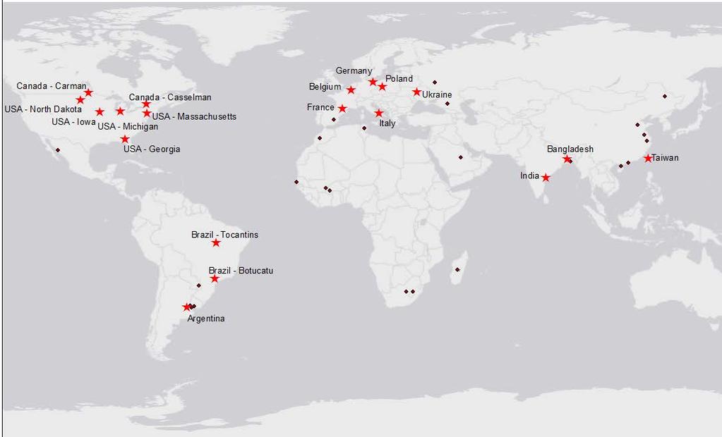


5 JECAM Partners
6 Partner Survey data LAI & Biomass 2018 Field Plan Argentina (3 Crops) Survey & LAI/Biomass Bangladesh (LAI & Moisture: Rice) LAI Belgium (~22 Crops, ~1004 fields) Brazil Sao Paulo Brazil Tocantins (~14 Land cover Types, ~1441 polygons) (9 Landover Types, ~900 polygons) Canada Carman (Survey) (LAI, Biomass, SM: Corn, Wheat) Canada Casselman (8 Crops, ~810 fields) Survey only Survey & LAI/Biomass * plus new site Cerrados Survey only Survey only France Toulouse (8 Crops, ~985 fields Survey & LAI/Biomass/Soil Moisture Germany (DEMMIN) (7 Crops, ~42 fields) (LAI & Biomass (in progress)) India (5 Crops, ~64 fields) (LAI: Biomass, Rice, Cotton, Banana, Sugarcane) Italy Apulia Tavoliere (5 Crops, ~53 fields) (LAI: Wheat, Barley & Oats) Survey & LAI/Biomass/Soil Moisture Survey & LAI/Biomass/Soil Moisture Survey & LAI/Biomass/Soil Moisture Poland (LAI: Wheat & Corn) LAI/Biomass/Soil Moisture Taiwan (LAI/Biomass: Rice) LAI/Biomass/Soil Moisture Ukraine (Survey)* (LAI: Wheat, Corn, Soy) USA Georgia (~14 Crops, ~586 fields) Survey & LAI/Biomass/Soil Moisture USA Iowa (Based on CDL) (SMAPVEX 2016 data) Survey (CDL) USA Massachusetts (Based on CDL) Survey (CDL & Survey) USA-Michigan (Based on CDL) Survey (CDL) & LAI USA North Dakota (Based on CDL) (LAI, SM, Biomass) (LAI, SM, Biomass + CDL) Field Data from JECAM Partners for 2014 to 2017 & 2018 Collection Plan 18 Partners provided field data including 10 for LAI/Biomass 16 partners committed to collecting field data in 2018 to go along with RADARSAT2 acquisitions RADARSAT2 quad polarization data will be collected to support the compact polarimetry portion of the experiment A new Partner - Brazil Cerrados!
7 EO SAR Data Preprocessing SAR-Simulation Terrain Correction Literature shows support for both SAR Simulation Terrain Correction and Range Doppler Correction (Bayanudin & Jatmiko 2016; Jiang et al., 2016) with SAR Simulation having slightly more rigorous results. As a matter of best practice SAR Simulation Terrain Correction was selected Normalization to incidence angle Only processed for Component 1. Component 2 uses Local Incidence angle as a parameter in the model Variations of normalization to: local incidence angle; projected local incidence angle; derived angle based upon ellipsoid; and no normalization were tested. While there were no significant differences between these for small-area, relatively flat sites, as a matter of best practice it was decided to normalize all images to local incidence angle. Order of operations testing Typically literature recommends filtering before ortho-rectifying /terrain correction. Testing of order of operations showed slightly degraded overall classification accuracies and longer processing time with filtering first.
8 SAR speckle filter testing: window size & filter type Test parameters Crop types of corn, soybean, wheat/no wheat/double crop with three test partners: Canada Casselman: small field size (~3 ha) (Complete) Argentina: medium field size (~25ha, In progress) USA Iowa: large field size (~30-60 ha continuous fields resulting in large homogenous areas of same crop types). Filters: Gamma Map (current AAFC operational filter), Touzi (Touzi, 2002) and Multi-Temporal (Quegan et al., 2000). Multiple window sizes and passes.
9 Gamma MAP & Touzi Filters GAMMA Map Filter Current operational filter with a 7x7 window; reduces speckle as a function of the co-efficient of variation within the window R is the center smoothed pixel, found as: R = I, for Ci less than or equal to Cu; OR R = BB II+ DD 2 AAAAAAAA, for Cu < Ci < Cmax; OR R = CP, for Ci greater than or equal to Cmax where: NLOOK = Number of Looks VAR = Variance in filter window CP = Initial center pixel value I = Mean value in the filter window Cu = Ci = II NNNNNNNNNN VVVVVV II Cmax = 2 CCCC 1+CCCC 2 ALFA = CCCC 2 CCCC 2 B = ALFA-NLOOK-1 Touzi Filter is an adaptive filter where the underlying features are identified based upon different detectors and sub-windows. As features are identified and filtered they are set aside ; Window size adapts as each filter step occurs. 5 iterative steps: 1. Point Target Filtering 2. Curvilinear Filtering 3. Homogenous Area Filtering 4. Multiresolution Edge Detection and Filtering 5. Stationary Area Filtering

10 Filtered RADARSAT2 VV Images Casselman, Ontario Casselman RADARSAT2-VV, May 29, 2016 Gamma MAP 7 x 7 Window Casselman RADARSAT2-VV, May 29, 2016 Gamma MAP 13 x 13 Window Casselman RADARSAT2-VV, May 29, 2016 Touzi 13 x13 Window Casselman RADARSAT2-VV, May 29, 2016 Touzi 25 x 25 Window
11 Filter Testing Outcomes 92.0 Comparison of different SAR filters and window sizes based upon the percent overall accuracy of AAFC's operational Decision Tree Classifier and SAR Only data. Multi-Temporal filter has poor results with less dense temporal stacks Percent overall accuracy Casselman Iowa Best Gamma MAP results Filter Type and Window Size Best Touzi results
12 JECAM Casselman Best Outcome (3 crops) Touzi Filter 25 x 25 window Wheat Corn Soybeans Wheat Corn Soybeans Overall accuracy: 88.9%, Kappa: 0.79 Gamma MAP 13 x 13 window Wheat Corn Soybeans Wheat Corn Soybeans Overall accuracy: 86.7%, Kappa: 0.75 User s Accuracy Wheat Corn Soybeans User s Accuracy Wheat Corn Soybeans Producer s Accuracy Producer s Accuracy McNemar s Chi-squared test with continuity correction (no statistical significance) McNemar's chi-squared = , df = 1, p-value <
13 JECAM Iowa Best Outcome (2 crops) Touzi Filter 13 x 13 window Corn Soybeans Corn Soybeans User s Accuracy Corn Soybeans Producer s Accuracy Overall accuracy: 90.5%, Kappa: 0.77 Gamma MAP 11 x 11 window Corn Soybeans User s Accuracy Producer s Accuracy Corn Soybeans Corn Soybeans Overall accuracy: 90.4%, Kappa: 0.77 No statistical difference
14 Finalize filter selection Next Steps Finalize pre-processing automation EO & field data stack creation and distribution to JECAM Partners (February/March) Running AAFC Crop Inventory Decision Tree Method on all Stacks Running Cloud Cover Iterations on All Stacks re-launch
15 Acknowledgements & Thanks Funding provided by the Canadian Space Agency under the Government Related Initiatives Program (GRIP). Many thanks to the Agriculture and Agri-Food Canada Earth Observation team especially Catherine Champagne, Patrick Rollin, Thierry Fisette, Ziad Aly, Elizabeth Eidness, and University of Guelph and University of Waterloo students: Hanna Holman, Benjamin Kovacs, Natalija Nikolic, and Holden Ciufo.
Monitoring Crop Leaf Area Index (LAI) and Biomass Using Synthetic Aperture Radar (SAR)
 and Biomass Using Synthetic Aperture Radar (SAR)") Monitoring Crop Leaf Area Index (LAI) and Biomass Using Synthetic Aperture Radar (SAR) Mehdi Hosseini, Heather McNairn, Andrew Davidson, Laura Dingle-Robertson *Agriculture and Agri-Food Canada JECAM SAR
Monitoring Crop Leaf Area Index (LAI) and Biomass Using Synthetic Aperture Radar (SAR) Mehdi Hosseini, Heather McNairn, Andrew Davidson, Laura Dingle-Robertson *Agriculture and Agri-Food Canada JECAM SAR
JECAM Synthetic Aperture Radar (SAR) Cross Site Experiments. JECAM Meeting, October 2016, Ukraine
 Cross Site Experiments. JECAM Meeting, October 2016, Ukraine") JECAM Synthetic Aperture Radar (SAR) Cross Site Experiments JECAM Meeting, October 2016, Ukraine Recent (2016) Developments Preliminary roadmap for the JECAM SAR cross sites experiments presented at 2015
JECAM Synthetic Aperture Radar (SAR) Cross Site Experiments JECAM Meeting, October 2016, Ukraine Recent (2016) Developments Preliminary roadmap for the JECAM SAR cross sites experiments presented at 2015
JECAM SAR Inter-Comparison Experiment. Applying Operational SAR and Optical Classification Methodologies to Multiple
 SAR Inter-Comparison Experiment Component 1: Crop Type Identification & Mapping Activity 1: Regions Applying Operational SAR and Optical Classification Methodologies to Multiple 1a. Applying Agriculture
GEOGLAM. JECAM Collaborative Priorities : Pierre Defourny (UCLouvain) and Andrew Davidson (AAFC) Co-leads of JECAM
 and Andrew Davidson (AAFC) Co-leads of JECAM") G20 Global Agriculture Monitoring Initiative GEOGLAM JECAM Collaborative Priorities : Pierre Defourny (UCLouvain) and Andrew Davidson (AAFC) Co-leads of JECAM Origins The GEO Agricultural Community of
G20 Global Agriculture Monitoring Initiative GEOGLAM JECAM Collaborative Priorities : Pierre Defourny (UCLouvain) and Andrew Davidson (AAFC) Co-leads of JECAM Origins The GEO Agricultural Community of
JECAM SAR cross sites experiments
 JECAM SAR cross sites experiments H. McNairn, I. Jarvis, A.Davidson, P. Defourny, G. Chomé, F. Waldner Agriculture and Agri-food Canada UCLouvain-Geomatics, Belgium and the JECAM SAR researchers and/or
Joint Experiment for Crop Assessment and Monitoring GEOGLAM Implementation Meeting Washington D.C. February 21, 2013
 Joint Experiment for Crop Assessment and Monitoring GEOGLAM Implementation Meeting Washington D.C. February 21, 2013 Ian Jarvis JECAM Sub-Task Lead Earth Observation Service, Agriculture and Agri-Food
and Development at AAFC
 SAR FOR AGRICULTURE- Research and Development at AAFC Heather McNairn*, Jarrett Powers, Jiali Shang, Amine Merzouki, Anna Pacheco, Thierry Fisette, Grant Wiseman, Saeid Homayouni and Mehdi Hosseini *Science
JECAM - Joint Experiment for Crop Assessment and Monitoring Recent progress with SAR/Optical Inter-Comparison Projects Ian Jarvis Co-lead of JECAM
 JECAM - Joint Experiment for Crop Assessment and Monitoring Recent progress with SAR/Optical Inter-Comparison Projects Ian Jarvis Co-lead of JECAM Science and Technology Branch, Agriculture and Agri-Food
The GEO Global Agricultural Monitoring (GEOGLAM) Initiative
 Initiative") The GEO Global Agricultural Monitoring (GEOGLAM) Initiative Chris Justice GEOGLAM Global Co-Lead The Center for Agricultural Monitoring Research, Department of Geographical Sciences, GEOGLAM Launched by
The GEO Global Agricultural Monitoring (GEOGLAM) Initiative Chris Justice GEOGLAM Global Co-Lead The Center for Agricultural Monitoring Research, Department of Geographical Sciences, GEOGLAM Launched by
Soil Moisture Monitoring for Agricultural Risk Assessment in Canada
 Soil Moisture Monitoring for Agricultural Risk Assessment in Canada Catherine Champagne, Patrick Cherneski, Trevor Hadwen, Antoun El Khoury National Agroclimate Information Service Science and Technology
PACRIM-2 Clear-fell Mapping Studies in New Zealand
 PACRIM-2 Clear-fell Mapping Studies in New Zealand D. Pairman, S.J. McNeill, D. McNab* and S.E. Belliss Landcare Research PO Box 69, Lincoln 8152, New Zealand. *Fletcher Challenge Forests. Email: pairmand@landcareresearch.co.nz
Ukraine. Space Research Institute
 Ukraine Demonstration objectives Space Research Institute Todeliver consistent information at field scalefor Ukraine using Sen2Agri system: Crop mask; Crop type; Crop status; Early crop area indicators,
Global Agricultural Monitoring International Coordination: GEOGLAM
 Global Agricultural Monitoring International Coordination: GEOGLAM Chris Justice NASA - Earth Observation for Food Security and Agriculture Consortium Department of Geographical Sciences, University of
AfriGEOSS in the Next Decade of Developing the GEOSS Andiswa Mlisa
 AfriGEOSS in the Next Decade of Developing the GEOSS Andiswa Mlisa GEO Secretariat Africa Leadership Conference (ALC) 2015, Sharm El Sheik, Egypt, 1 4 December 2015 GEO Vision Ministers Adopted the GEO
Agricultural Satellite Monitoring and Crop Yield Forecasting in. Who we are: Current Expertise & International Activities
 Agricultural Satellite Monitoring and Crop Yield Forecasting in Ukraine N. Kussul 1, S. Skakun 1, A. Shelestov 1,2 1 Space Research Institute NASU-SSAU 2 National University of Life and Environmental Sciences
The NISAR Mission. Paul Siqueira Emerging Technologies and Methods in Earth Observation for Agriculture Monitoring College Park, 2018
 The NISAR Mission Paul Siqueira Emerging Technologies and Methods in Earth Observation for Agriculture Monitoring College Park, 2018 Flyer A one-page paper-flyer is available with more information NISAR
JECAM and the Manitoba Super Site
 JECAM and the Manitoba Super Site GEO-DRI Drought Monitoring Workshop May 10 & 11, 2010 Grant Wiseman, M.Sc. AAFC, AESB, Winnipeg, Canada grant.wiseman@agr.gc.ca Joint Experiments on Crop Assessment and
the wheat fields is small, and as for fields of puddling and leveling in winter and other fields in similar, the difference is small. It is conclude t
 OBSERVATION OF JAPANESE PADDY RICE FIELDS USING MULTI TEMPORAL AND POLARIMETRIC PALSAR DATA PI No.365 Naoki ISHITSUKA 1, Genya SAITO 2, Fan YANG 3, Chinatsu YONEZAWA 4 and Shigeo OGAWA 5 1 National Institute
Understanding Agriculture Worldwide
 Institute of Farm Economics agri benchmark Cash Crop Understanding Agriculture Worldwide Global Forum 2012, South Africa Yelto, Coordinator of agri benchmark Cash Crop Global Partners: Content 1. What
International Benchmarks for Wheat Production
 September, 2016 International Benchmarks for Wheat Production Michael Langemeier, Associate Director, Center for Commercial Agriculture Elizabeth Yeager, Department of Agricultural Economics, Kansas State
MONITORING OF CROP GROWTH AND SOIL MOISTURE RETRIEVAL USING NISAR DATA. HARI SHANKER SRIVASTAVA Indian Institute of Remote Sensing (IIRS),
,") NISAR Science Workshop 2015 Space Applications Centre MONITORING OF CROP GROWTH AND SOIL MOISTURE RETRIEVAL USING NISAR DATA HARI SHANKER SRIVASTAVA Indian Institute of Remote Sensing (IIRS), Indian Space
NISAR Science Workshop 2015 Space Applications Centre MONITORING OF CROP GROWTH AND SOIL MOISTURE RETRIEVAL USING NISAR DATA HARI SHANKER SRIVASTAVA Indian Institute of Remote Sensing (IIRS), Indian Space
Soil moisture observations and remote sensing at Brightwater Creek, Scotty Creek and Trail Valley Creek
 Soil moisture observations and remote sensing at Brightwater Creek, Scotty Creek and Trail Valley Creek Aaron Berg, Tracy Rowlandson, Travis Burns, Rachel Humphrey, Rebecca Warren, Allan Merchant, Matthew
Market utilization overview. Grain Farmers of Ontario
 Market utilization overview Grain Farmers of Ontario Introduction AGRICULTURE IS AN important economic driver for the province of Ontario. In 2016, more than 13 million metric tonnes of barley, corn,
GEO Joint Experiment for Crop Assessment and Monitoring (JECAM): Template for Research Progress Report
: Template for Research Progress Report") GEO Joint Experiment for Crop Assessment and Monitoring (JECAM): Date: 2016/02/04 JECAM Test Site Name: Burkina Faso - Koumbia Team Leader and Members: Team Leader: Raffaele Gaetano Template for Research
GEO Joint Experiment for Crop Assessment and Monitoring (JECAM): Date: 2016/02/04 JECAM Test Site Name: Burkina Faso - Koumbia Team Leader and Members: Team Leader: Raffaele Gaetano Template for Research
Chapter 2. Crop and environmental conditions in major production zones
 22 Chapter 2. Crop and environmental conditions in major production zones Chapter 2 presents the same indicators RAIN, TEMP, RADPAR, and BIOMSS as those used in Chapter 1, and combines them with the agronomic
Sentinels for Agriculture Global, Operational, Open, Reliable
 Sentinels for Agriculture Global, Operational, Open, Reliable Benjamin Koetz European Space Agency Earth Observation Directorate ESA UNCLASSIFIED - For Official Use Sentinel-2B Launch Tonight, 7 th of
The Carbon Footprint of Canadian Crops. Don O Connor (S&T) 2 Consultants Inc. Calgary, Alberta April 11, 2017
 2 Consultants Inc. Calgary, Alberta April 11, 2017") The Carbon Footprint of Canadian Crops Don O Connor (S&T) 2 Consultants Inc. Calgary, Alberta April 11, 2017 Topics What is a Carbon Footprint? System Boundaries Regional Approach Crops Studied Data Collection
The Carbon Footprint of Canadian Crops Don O Connor (S&T) 2 Consultants Inc. Calgary, Alberta April 11, 2017 Topics What is a Carbon Footprint? System Boundaries Regional Approach Crops Studied Data Collection
Statistical Overview of the Canadian Honey and Bee Industry and the Economic Contribution of Honey Bee Pollination
 Statistical Overview of the Canadian Honey and Bee Industry and the Economic Contribution of Honey Bee Pollination 2013-2014 Prepared by: Horticulture and Cross Sectoral Division Agriculture and Agri-Food
IN CANADA 2017 GROWING SEASON Canadian Wheat Crop in Review
 The 2017 growing season in Canada was diverse across the country, including in the prairie region. Most of the Prairies experienced dry and hot temperatures, causing yield declines in some areas. This
Rice Monitoring from Space?
 Rice Monitoring from Space? Thuy Le Toan CESBIO, Toulouse, France The GEORICE Project Towards Operational Rice Monitoring Benjamin Koetz Thuy Le Toan, Phan Thi Hoa Alexandre Bouvet Lam Dao Nguyen, VNSC
Applications of SAR Polarimetry on Land: Soil Moisture and Wetlands
 Applications of SAR Polarimetry on Land: Soil Moisture and Wetlands Session Summary and Recommendations R. Touzi and S. Cloude Session Summary T. Jagdhuber et. Al.: Polarimetric Decompositions for Soil
Department of Environmental Sciences, Nanjing Institute of Meteorology, Nanjing , China
 Evaluation of Remote Sensing Approaches to Monitor Crop Conditions under Specific Input Levels and Cropping Diversity X. Guo 1, Y. Zheng 1,4, O. Olfert 2, S. Brandt 3, A.G. Thomas 2, R.M. Weiss 2, L. Sproule
Providing crop information using RADARSAT-1 and satellite optical imagery
 PREPRINT/PRÉTIRAGE Providing crop information using RADARSAT-1 and satellite optical imagery H. McNairn 1, J. Ellis 2, J.J. van der Sanden 1, T. Hirose 2 and R.J. Brown 1 1 Canada Centre for Remote Sensing
Chapter 2. Crop and environmental conditions in major production zones
 22 Chapter 2. Crop and environmental conditions in major production zones Chapter 2 presents the same indicators RAIN, TEMP, RADPAR, and BIOMSS used in Chapter 1, and combines them with the agronomic indicators
BACKSCATTER ANALYSIS USING MULTI-TEMPORAL SENTINEL-1 SAR DATA FOR CROP GROWTH OF MAIZE IN KONYA BASIN, TURKEY
 BACKSCATTER ANALYSIS USING MULTI-TEMPORAL SENTINEL-1 SAR DATA FOR CROP GROWTH OF MAIZE IN KONYA BASIN, TURKEY S. Abdikan 1 *, A. Sekertekin 2, M. Ustunern 3, F. Balik Sanli 3, R. Nasirzadehdizaji 3 1 Dept.
World Agricultural Outlook Board Interagency Commodity Estimates Committee Forecasts. Lockup Briefing July 11, 2014
 World Agricultural Outlook Board Interagency Commodity Estimates Committee Forecasts Lockup Briefing World Wheat Production Country or Region estimate 2014/15 forecast June 11 Million Tons Percent Percent
AGRICULTURAL GREENHOUSE GASES PROGRAM (AGGP)
") AGRICULTURAL GREENHOUSE GASES PROGRAM (AGGP) GLOBAL RESEARCH ALLIANCE (GRA) December 10, 2012 L. Tollefson GLOBAL RESEARCH ALLIANCE (GRA) Originated at Copenhagen summit and launched 2009 Vision was to
AGRICULTURAL GREENHOUSE GASES PROGRAM (AGGP) GLOBAL RESEARCH ALLIANCE (GRA) December 10, 2012 L. Tollefson GLOBAL RESEARCH ALLIANCE (GRA) Originated at Copenhagen summit and launched 2009 Vision was to
Collaboration of Space Research Institute NASU-SSAU with EC JRC on satellite monitoring for food security: background and prospects
 Collaboration of Space Research Institute NASU-SSAU with EC JRC on satellite monitoring for food security: background and prospects Prof. Nataliia Kussul 1 Space Research Institute NASU-SSAU, Ukraine Context
AGRICULTURAL CROP MAPPING USING OPTICAL AND SAR MULTI- TEMPORAL SEASONAL DATA: A CASE STUDY IN LOMBARDY REGION, ITALY
 AGRICULTURAL CROP MAPPING USING OPTICAL AND SAR MULTI- TEMPORAL SEASONAL DATA: A CASE STUDY IN LOMBARDY REGION, ITALY G. Fontanelli, A. Crema, R. Azar, D. Stroppiana, P. Villa, M. Boschetti Institute for
Cropland Mapping with Satellite Data
 Cropland Mapping with Satellite Data Rick Mueller Head/Spatial Analysis Research USDA/National Agricultural Statistics Service Border-Area Water Management Remote Sensing Workshop Agenda Cropland Data
Emerging Technologies and Methods in Earth Observation for Agricultural Monitoring
 Workshop Report Emerging Technologies and Methods in Earth Observation for Agricultural Monitoring February 13-15, 2018, United States Department of Agriculture, Beltsville Maryland A joint workshop sponsored
DMC 22m Sensors for Supertemporal Land Cover Monitoring. Gary Holmes DMC International Imaging Ltd June 2014
 DMC 22m Sensors for Supertemporal Land Cover Monitoring Gary Holmes DMC International Imaging Ltd June 2014 DMC 2 nd Generation Satellites UK-DMC2 and Deimos-1 launched 29 th July 2009 650km swath width
GEOGLAM Data Requests
 GEOGLAM Data Requests 21 April 2016 Alyssa Whitcraft, UMD/GEOGLAM Sec. Overview A few national scale requests received Mostly for new acquisitions, one for archival data COVE Coverage Analyzer bugs being
Ера "великих даних" та інноваційні проекти в супутниковому моніторингу
 Ера "великих даних" та інноваційні проекти в супутниковому моніторингу Проф. д.т.н. Куссуль Наталія Миколаївна, к.т.н. Колотій А.В., М.С. Лавренюк Інститут космічних досліджень НАН України та ДКА України
GEOGLAM Global Agricultural Monitoring
 GEOGLAM Global Agricultural Monitoring Dr. Selma Cherchali on behalf of the GEOGLAM Crop Monitor team Land and Hydrology Program Manager Science, Application and innovation Directorate, CNES Co-Lead, CEOS
Cropland Mapping and area estimation method in CropWatch. Nana Yan, Miao Zhang, Bingfang Wu, Bo Chen RADI, CAS June, 2015
 Cropland Mapping and area estimation method in CropWatch Nana Yan, Miao Zhang, Bingfang Wu, Bo Chen RADI, CAS June, 2015 Outline Background Methodology in CropWatch Recent updates of crop classification
H2020 SENSAGRI project: developing prototypes for new Copernicus services for agriculture
 GEOINT for Environmental Compliance Assurance in rural areas/agriculture H2020 SENSAGRI project: developing prototypes for new Copernicus services for agriculture Antonio Ruiz Verdú University of Valencia
Earth Observations based agricultural monitoring over EEU countries: concept and first results of the SIGMA RBK project
 Earth Observations based agricultural monitoring over EEU countries: concept and first results of the SIGMA RBK project Bartalev Sergey, Loupian Evgeny, Plotnikov Dmitry and Tolpin Vladimir Space Research
Summary of WASDE and Production USDA
 Summary of WASDE and Production USDA The following information are summary and extracts from the latest, AUG 2016, WASDE and World Agricultural Production reports provided by the United States Department
Rapid Land Use and Land Cover Database Development
 Rapid Land Use and Land Cover Database Development Utility of the Land Use and Land Cover Database Socio-Economic Climate Change Water Quantity Water Quality 2 Overview of the Mapping Approach Goal: Develop
Towards Near Daily Monitoring of Inundated Areas over North America through Multi-Source Fusion of Optical and Radar Data
 Towards Near Daily Monitoring of Inundated Areas over North America through Multi-Source Fusion of Optical and Radar Data Chengquan Huang 1, Ben DeVries 1, Wenli Huang 1, Jiaming Lu 1, Megan Lang 2, John
Barrax JECAM Site (Spain)
") Barrax JECAM Site (Spain) JECAM/GEOGLAM Science Meeting Brussels, Belgium 16-17 November, 2015 Fernando Camacho Consuelo Latorre Fernando de la Cruz Location Site Description Barrax has been a study area
Barrax JECAM Site (Spain) JECAM/GEOGLAM Science Meeting Brussels, Belgium 16-17 November, 2015 Fernando Camacho Consuelo Latorre Fernando de la Cruz Location Site Description Barrax has been a study area
K&C Phase 4 Brief project essentials. Asia-RiCE: Rice Crop Estimation and Monitoring. Shin-ichi Sobue Remote Sensing Technology Center of Japan
 K&C Phase 4 Brief project essentials Asia-RiCE: Rice Crop Estimation and Monitoring Shin-ichi Sobue Remote Sensing Technology Center of Japan Science Team meeting #21 Phase 4 Kick-off Kyoto Research Park,
APPLICATION OF FINE QUAD-POLARIZATION RADARSAT-2 DATA AND SUPPORT VECTOR MACHINES TO CLASSIFY OFF- SEASON RICE PADDIES
 Geotec., Const. Mat. & Env., DOI: https://doi.org/10.21660/2018.46.sgi177 ISSN: 2186-2982 (Print), 2186-2990 (Online), Japan APPLICATION OF FINE QUAD-POLARIZATION RADARSAT-2 DATA AND SUPPORT VECTOR MACHINES
Update on Activities of the Canadian Group on Earth Observations (CGEO) Fourth Drought Research Initiative Workshop Regina, Saskatchewan
 Fourth Drought Research Initiative Workshop Regina, Saskatchewan") Update on Activities of the Canadian Group on Earth Observations (CGEO) Fourth Drought Research Initiative Workshop Regina, Saskatchewan Ken Korporal Canadian GEO Secretariat 26 January 2009 Outline Links
Update on Activities of the Canadian Group on Earth Observations (CGEO) Fourth Drought Research Initiative Workshop Regina, Saskatchewan Ken Korporal Canadian GEO Secretariat 26 January 2009 Outline Links
GEOGLAM : Global Agricultural Monitoring
 GEOGLAM : Global Agricultural Monitoring Jai Singh Parihar on behalf of GEOGLAM Task Team (Chris Justice, Shinichi Sobue, Olivier Leo, Wu Bingfang, Derrick Williams, Inbal Becker-Reshef, Ian Jarvis, Terry
ESTIMATION OF THE RICE YIELD IN THE MEKONG DELTA USING SAR DUAL POLARISATION DATA
 ESTIMATION OF THE RICE YIELD IN THE MEKONG DELTA USING SAR DUAL POLARISATION DATA Nguyen Lam-Dao *a, Phung Hoang-Phi a, Juliane Huth b and Phung Cao-Van c a GIS and Remote Sensing Research Center, HCMC
Mapping smallholder agriculture using simulated Sentinel-2 data; optimization of a Random Forest-based approach and evaluation on Madagascar site
 Mapping smallholder agriculture using simulated Sentinel-2 data; optimization of a Random Forest-based approach and evaluation on Madagascar site Lebourgeois, V., Dupuy, S., Vintrou, E., Ameline, M., Butler,
REDD+ for the Guiana Shield. Terms of Reference SAR Technical Training for Forest Mapping
 REDD+ for the Guiana Shield Technical and Regional Platform for the Development of REDD+ in the Guiana Shield Terms of Reference SAR Technical Training for Forest Mapping Project Owner: Office National
Mapping major crops using Sentinel Images for Nepal
 Mapping major crops using Sentinel Images for Nepal (Strengthening Agriculture Advisory by Establishing Agriculture Information Dashboard) SARI workshop, Delhi, May 2-4, 2017 Nabin Kumar Yadav, Faisal
MATOPIBA - BRAZIL. JECAM/GEOGLAM Science Meeting Ottawa, Canada July 2014
 MATOPIBA - BRAZIL JECAM/GEOGLAM Science Meeting Ottawa, Canada 21 23 July 2014 Margareth Simões Rodrigo Ferraz, Pedro Freitas, Ademir Fonseca, José Polidoro (Embrapa) Tapajos site moved to Tocantins site
Global Agricultural Monitoring International Coordination: GEOGLAM
 Global Agricultural Monitoring International Coordination: GEOGLAM Chris Justice Inbal Becker-Reshef, Christina Justice, Brian Barker, Michael Humber The Center for Agricultural Monitoring Research, Department
Chapter 2. Farming intensity and stress in major production zones
 24 Chapter 2. Farming intensity and stress in major production zones With Chapter 1 presenting a global overview of key environmental indices relevant to agriculture, Chapter 2 provides more detail on
USDA lowered the 2010/11 wheat carry out by 49 million and decreased 2010/11 Yield by.2 bushels/acre.
 Friday October 8 th 2010 World Ag Supply & Demand Estimates Very Bullish for Corn Bullish for Soybeans Friendly U.S. Wheat USDA lowered the 2010/11 corn carry out by 214 million and decreased 2010/11 Yield
Direct Land Use Change Assessment Tool
 v Direct Land Use Change Assessment Tool Update description - Title Date Place Author Direct Land Use Change Assessment Tool 27-9-2017 Gouda, NL Pieter van de Vijver Blonk Consultants Blonk Consultants
Mapping Coastal Great Lakes Wetlands and Adjacent Land use Through Hybrid Optical-Infrared and Radar Image Classification Techniques
 Mapping Coastal Great Lakes Wetlands and Adjacent Land use Through Hybrid Optical-Infrared and Radar Image Classification Techniques Laura L. Bourgeau-Chavez, Kirk Scarbrough, Mary Ellen Miller, Zach Laubach,
A Prospective Analysis of US-Brazil Biofuel Policies
 A Prospective Analysis of US-Brazil Biofuel Policies Héctor M. Núñez and Hayri Önal Madhu Khanna, Xiaoguang Chen, Haixiao Huang University of Illinois at Urbana-Champaign Energy Biosciences Institute CTBE-IEA
Crop mapping with satellite data
 Crop mapping with satellite data Dr. C.S. Murthy Head, Agricultural Sciences and Applications National Remote Sensing Centre, Hyderabad murthy_cs@nrsc.gov.in, csmurthy09@gmail.com Geospatial Technology
Assessment of tropical forest biomass: A challenging objective for the Biomass mission
 Assessment of tropical forest biomass: A challenging objective for the Biomass mission Thuy Le Toan, Ludovic Villard, Ho Tong M. D., Thierry Koleck, CESBIO, Toulouse, France Pascale Dubois Fernandez, ONERA,
GEOGLAM: Science-driven information supporting decisions in agricultural markets and food security through use of earth observations
 GEOGLAM: Science-driven information supporting decisions in agricultural markets and food security through use of earth observations Inbal Becker-Reshef Program Scientist GEOGLAM Secretariat Co-Director
GEO Joint Experiment for Crop Assessment and Monitoring (JECAM): 2013 Progress Report
: 2013 Progress Report") GEO Joint Experiment for Crop Assessment and Monitoring (JECAM): 2013 Progress Report March 2013 Executive Summary This report shows the progress that GEO JECAM (Joint Experiment for Crop Assessment and
GEO Joint Experiment for Crop Assessment and Monitoring (JECAM): 2013 Progress Report March 2013 Executive Summary This report shows the progress that GEO JECAM (Joint Experiment for Crop Assessment and
MADAGASCAR (Antsirabé) site
 site") MADAGASCAR (Antsirabé) site JECAM/GEOGLAM Science Meeting Ottawa, Canada 21 23 July 2014 Valentine Lebourgeois, Agnès Bégué, Elodie Vintrou, Julie Dusserre Collaboration with FOFIFA Site Description Madagascar,
MADAGASCAR (Antsirabé) site JECAM/GEOGLAM Science Meeting Ottawa, Canada 21 23 July 2014 Valentine Lebourgeois, Agnès Bégué, Elodie Vintrou, Julie Dusserre Collaboration with FOFIFA Site Description Madagascar,
AGRI-News. Magnusson Consulting Group. In this issue: Canadian Wheat Update. Smaller Supplies to Limit Brazil s 2018/19 Soybean Exports
 AGRI-News Magnusson Consulting Group Volume 2, Issue 3 March 2019 Smaller Supplies to Limit Brazil s 2018/19 Soybean Exports Record soybean exports in 2017/18, coupled with a reduction in the 2018/19 harvest,
HYDRO-ECOLOGICAL MONITORING OF COASTAL MARSH USING HIGH TEMPORAL RESOLUTION SENTINEL-1 TIME SERIE
 HYDRO-ECOLOGICAL MONITORING OF COASTAL MARSH USING HIGH TEMPORAL RESOLUTION SENTINEL-1 TIME SERIE C.Cazals (a), S. Rapinel (b,c), P-L. Frison(a), A. Bonis(b), Mercier, Mallet, Corgne, J-P. Rudant(a) (a)
Classification of arable land using multitemporal
 Mr. Anser Mehmood Classification of arable land using multitemporal TerraSAR-X data Duration of the Thesis: 6 months Completion: April 2013 Tutor: Dipl.- Geogr. René Pasternak Examiner: Prof. Dr.-Ing.
Antsirabe (Madagascar)
") Antsirabe (Madagascar) JECAM/GEOGLAM Science Meeting Brussels, Belgium 16-17 November, 2015 V.Lebourgeois, E.Vintrou, S.Dupuy, A.Bégué, J.Dusserre, M.Ameline, B.Bellon De La Cruz F.Ramahandry, C.Nativel
Antsirabe (Madagascar) JECAM/GEOGLAM Science Meeting Brussels, Belgium 16-17 November, 2015 V.Lebourgeois, E.Vintrou, S.Dupuy, A.Bégué, J.Dusserre, M.Ameline, B.Bellon De La Cruz F.Ramahandry, C.Nativel
AGRICULTURAL PERFORMANCE MONITORING WITH POLARIMETRIC SAR AND OPTICAL IMAGERY
 AGRICULTURAL PERFORMANCE MONITORING WITH POLARIMETRIC SAR AND OPTICAL IMAGERY Tishampati Dhar [1][2], Doug Gray [1], Carl Menges [2] [1] Dept of Electrical and Electronic Engineering, University of Adelaide,
CANADA: OUTLOOK FOR PRINCIPAL FIELD CROPS February 16, 2018
 CANADA: OUTLOOK FOR PRINCIPAL FIELD CROPS February 16, 2018 Market Analysis Group/Grains and Oilseeds Division Sector Development and Analysis Directorate/Market and Industry Services Branch Director:
Evaluation of Sentinel-1A Data For Above Ground Biomass Estimation in Different Forests in India. Krishna Prasad Vadrevu NASA MSFC SERVIR
 Evaluation of Sentinel-1A Data For Above Ground Biomass Estimation in Different Forests in India Krishna Prasad Vadrevu NASA MSFC SERVIR Evaluation of Sentinel-1A Data Over Different Forest Types of India
Wednesday July 11, 2012 World Ag Supply & Demand Report
 World Ag Supply & Demand Report U.S. 2011/12 Old Crop Corn is neutral Global Old Crop Corn is neutral USDA estimates the 2011/12 U.S. corn carryout at 903 million bushels, up from 851 million bushels from
Developing a Global Agricultural Monitoring System of Systems. Context for Agriculture Monitoring. Chris Justice University of Maryland
 Developing a Global Agricultural Monitoring System of Systems Chris Justice University of Maryland IRSA Beijing, Feb 11-13 th 2009 Energy and Food Prices Closely Linked Energy prices affect ag inputs,
Earth Observation Technologies for Crop Monitoring: A Workshop to Promote Collaborations among GEOGLAM/JECAM/Asia-RiCE 2018
 Earth Observation Technologies for Crop Monitoring: A Workshop to Promote Collaborations among GEOGLAM/JECAM/Asia-RiCE 2018 Meeting Objectives 17-20 September 2018 Taichung City (Taiwan) GEO Global Agricultural
BelSAR : an Airborne Campaign for L-Band Full-Polarimetric and Interferometric Bistatic SAR Measurements over Belgium
 BelSAR : an Airborne Campaign for L-Band Full-Polarimetric and Interferometric Bistatic SAR Measurements over Belgium ESA Contract No. 4000117154/16/NL/FF/mc Anne Orban and Christian Barbier, Signal Processing
CROP SPECIES RECOGNITION AND DISCRIMINATION PADDY-RICE-GROWING- FIELDS FROM REAPED-FIELDS BY THE RADAR VEGETATION INDEX (RVI) OF ALOS-2/PALSAR2
 OF ALOS-2/PALSAR2") CROP SPECIES RECOGNITION AND DISCRIMINATION PADDY-RICE-GROWING- FIELDS FROM REAPED-FIELDS BY THE RADAR VEGETATION INDEX (RVI) OF ALOS-2/PALSAR2 Y. Yamada a a Institute for Rural Engineering, National Agriculture
CROP SPECIES RECOGNITION AND DISCRIMINATION PADDY-RICE-GROWING- FIELDS FROM REAPED-FIELDS BY THE RADAR VEGETATION INDEX (RVI) OF ALOS-2/PALSAR2 Y. Yamada a a Institute for Rural Engineering, National Agriculture
ISTA - Variety Committee DNA Working Group
 ISTA - Variety Committee DNA Working Group... the Technical Committee for Species and Variety Testing Report of Activities during 2007-2010 goals achieved aims for the future Cheryl Dollard The strategy
BelSAR : an Airborne Campaign for L-Band Full-Polarimetric and Interferometric Bistatic SAR Measurements over Belgium
 BelSAR : an Airborne Campaign for L-Band Full-Polarimetric and Interferometric Bistatic SAR Measurements over Belgium ESA Contract No. 4000117154/16/NL/FF/mc Anne Orban and Christian Barbier, Signal Processing
ecoinvent data v2.0 biomass production new agricultural products
 2 nd International ecoinvent Meeting Lausanne, March 14, 2008 ecoinvent data v2.0 biomass production new agricultural products Thomas Kägi & Thomas Nemecek, Agroscope Reckenholz- Tänikon Research Station
Taikichiro Mori Memorial Research Grants Graduate Student Researcher Development Grant Report
 Taikichiro Mori Memorial Research Grants Graduate Student Researcher Development Grant Report February 2016 Research Project: Detection and delineation of water bodies using Synthetic Aperture Radar data
CORN: USDA REPORTS FAIL TO CONFIRM SMALLER SUPPLIES
 CORN: USDA REPORTS FAIL TO CONFIRM SMALLER SUPPLIES JANUARY 2001 Darrel Good No. 1 Summary Corn prices managed a significant rally from late September to late December 2000, partially on anticipation of
Identification of Paddy Rice Areas Using SAR: Some Case Studies in Japan
 JARQ 52 (3), 197-204 (2018) https://www.jircas.go.jp Determination of Paddy Rice Planted Area Using SAR REVIEW Identification of Paddy Rice Areas Using SAR: Some Case Studies in Japan Naoki ISHITSUKA*
Stocktaking Overview of the G20. Global Agricultural Monitoring Initiative
 Stocktaking Overview of the G20 Global Agricultural Monitoring Initiative February 2018 Background The Group on Earth Observations Global Agricultural Monitoring Initiative (GEOGLAM) was initially launched
Stocktaking Overview of the G20. Global Agricultural Monitoring Initiative
 Stocktaking Overview of the G20 Global Agricultural Monitoring Initiative February 2018 Background The Group on Earth Observations Global Agricultural Monitoring Initiative (GEOGLAM) was initially launched
Friday Aug 10, 2012 World Ag Supply & Demand Report
 Friday Aug 10, 2012 World Ag Supply & Demand Report U.S. 2011/12 Old Crop Corn is Supportive Global Old Crop Corn is Slightly Bearish USDA estimates the 2011/12 U.S. corn carryout at 1,021 million bushels,
GEOGLAM Crop Monitor
 GEOGLAM Crop Monitor No. 26 March 2016 Prepared by members of the GEOGLAM Community of Practice Coordinated by the University of Maryland The Crop Monitor is a part of GEOGLAM, a GEO global initiative.
Tropical Forest Mapping using Multiband Polarimetric and Interferometric SAR Data
 Tropical Forest Mapping using Multiband Polarimetric and Interferometric SAR Data Kemal Unggul Prakoso Wageningen University, Nieuwe Kanaal 11, 6709 PA Wageningen, The Netherlands tel:+31-317-483576, fax:+31-317-484885,
Variety Committee. Ana Laura Vicario. Committee report
 Variety Committee Chair Vice-chair Ana Laura Vicario Emanuela Casarini Committee report 2013-2014 Committee members Chair 1 Ana Laura Vicario AR - Argentina Vice-chair 2 Emanuela Casarini IT Italy Member
World Agricultural Outlook Board Interagency Commodity Estimates Committee Forecasts. Lockup Briefing June 11, 2014
 World Agricultural Outlook Board Interagency Commodity Estimates Committee Forecasts Lockup Briefing World Wheat Production Country or Region 2014/15 Million Tons World 714.0 701.6 0.7-1.7 United States
Sensitivity of vegetation indices derived from Sentinel-2 data to change in biophysical characteristics
 Sensitivity of vegetation indices derived from Sentinel-2 data to change in biophysical characteristics Dragutin Protić, Stefan Milutinović, Ognjen Antonijević, Aleksandar Sekulić, Milan Kilibarda Department
Identification of Crop Areas Using SPOT 5 Data
 Identification of Crop Areas Using SPOT 5 Data Cankut ORMECI 1,2, Ugur ALGANCI 2, Elif SERTEL 1,2 1 Istanbul Technical University, Geomatics Engineering Department, Maslak, Istanbul, Turkey, 34469 2 Istanbul
Results from the Land & Environment Crop & Drought. projects in Dragon-3. Chaired by S. Pignatti & F. Jinlong
 Results from the Land & Environment Crop & Drought projects in Dragon-3 Chaired by S. Pignatti & F. Jinlong Project 10367: Desertification Monitoring and Assessment Committed products optimal indicators