Flood Fighting and Surveillance
|
|
|
- Alexandrina Webb
- 6 years ago
- Views:
Transcription


1 Flood Fighting and Surveillance Don Moses Civil Engineer February 2016 US Army Corps of Engineers 1
2 Agenda Levee Design Common Failure Modes Surveillance/Inspection Flood Fighting 2
3 Levee Design Issues Slope Stability Thru Seepage Underseepage Critical Exit Gradient Berm Weight Overtopping Resistance Streambank Erosion Protection 3

4 Levee Components Riverside Natural Blanket Riverside Riprap Protection Riverside Impervious Face and Cutoff Random Fill Core Landside Seepage Control Berm Topsoil and Vegetative Cover Landside Toe Drain and Relief Wells 4

5 Underseepage Control Relief Wells 5

6 Failure Modes Overtopping Through Seepage/Piping Underseepage/Piping Slope Failure Riverside Erosion 6

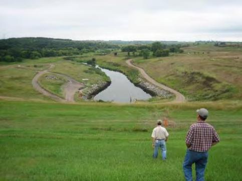
7 Overtopping at Access Ramp (June 17, 2011) Low spots created by traffic Common to all levees Low spots created by levee foundation settlement Sand levee can not resist overtopping Clay levees are more resistant to overtopping but will eventually fail with sustained overtopping 7

8 L550 North of Hwy 136 8
9 Contributing Factors for Through Seepage Lack of Clay Riverside Face on a Sand Levee Animal Holes Undocumented non engineered levee penetrations Culvert Separations Culvert Pervious Bedding Exposed to River 9


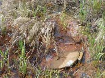
10 Through Seepage/Piping Water Side Levee Land Side Water exiting on levee slope Burrows Animal Burrows - Beavers and Badgers Rodent Hole Rodent Caught in the Act 10


")
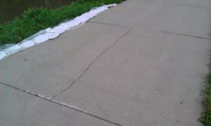
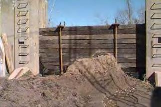
11 Failure Mode Through Seepage/Piping Drainage structures and other changes or transition areas (e.g., levee to floodwall) are potential weak points 11

12 Failure Mode Through Seepage/Piping 12
13 Contributing Factors for Under Seepage Geological cross section Remnant River Meanders Lack of Riverside Natural Impervious Blanket Damaged blanket from erosion or manmade excavation Animal holes Encroachments non engineered levee penetrations Encroachments landside ditch excavations Encroachments landside quarry excavations Inefficient relief wells and toe drains Historic levee loading Riverside erosion 13

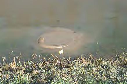

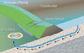
14 Underseepage/Piping Water Flow Pipe Development (Movement of Material) Sand Boils with movement of material 14

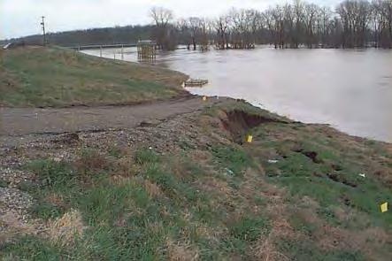
15 Highway 2 (June 17, 2011) 15

16 Highway 2 16

17 Highway 2 3 Mile Setback 17

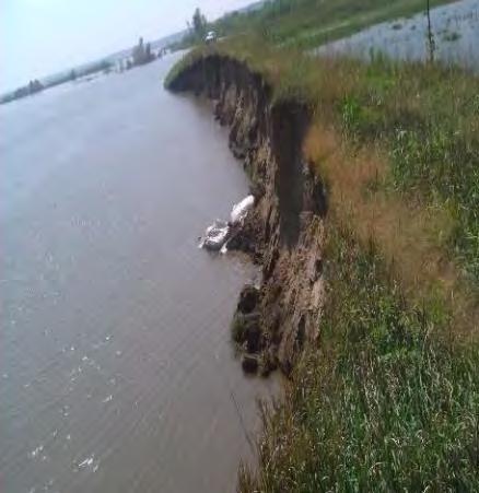
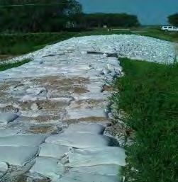
18 Highway 2 Sand Boils 18

19 Erosion & Landside Sandboils at Riverside Ramps 19

20 Same Location - After Water Receded 20

21 L575 Riverside swirl - indicates seepage through levee 21

22 L575 - Landside of Riverside swirl Water exiting after seeping through levee 22

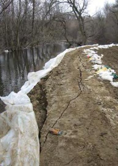
23 L575 - Levee collapses on itself Cause by seepage through the levee


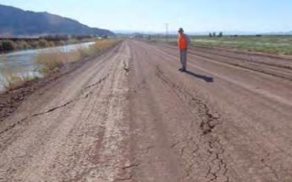
24 Failure Mode Slope Failure Water Water Riverside Slope Failure *Most Common Landside Slope Failure Note stakes and flagging 24


25 Failure Mode Slope Failure 25

26 Areas of Potential Erosion Riverside levees Riverside ramps Riverside fences Historic Borrow Pits Levee Alignment Floodplain Geometry Trees 26
")
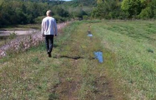
27 Corning and L536 (June 11, 2011) 27
 28")
28 L536 Corning Levee (June 24, 2011) 28
29 Surveillance/Inspections 29
30 Flood Surveillance Teams Partnered for safety and efficiency Report to EOC Participate in pre and post day hand off meetings What is the current & forecasted flood situation Project Assignments 30
31 Surveillance References Drive the levee with the project sponsor Operations and Maintenance Manuals Annual Levee Inspections Periodic Inspections Project personnel Google Earth Historic and Recent Aerials 31
32 Surveillance Tools Cell phones Good project map Know your evacuation routes Know your nearest hospital location Get on a helicopter early in the process GPS cameras Rod and level Tape 32
33 Surveillance Tools Lathe Markers Flagging / Spray Paint Life Jackets Safety Vests Binoculars Flash Lights Food and Water 33

34 Flood Surveillance/Inspections floodwall_line levee_flood_fight_point closure_structure_line pump_station_point levee_failure_point borehole_point sand_boil_point levee_crossing_point levee_centerline protected_area rehabilitation line piezometer_point cross_section_line levee_relief_well_point levee_station_point encroachment point gravity_drain_line 34
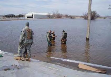
35 Surveillance Activities Know failure modes and indications of distress EARLY IDENTIFICATION OF DISTRESS IS CRITICAL TO EMERGENCY RESPONSE (Repairs or Evacuations) 35
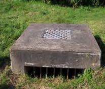
36 Walk the Levee Crest and Riverside Toe Riverside Issues Levee freeboard read staff gages Erosion High Water Velocities / Turbulent Flows Crest Issues Overtopping Cracking / Slides 36
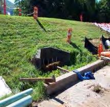
37 Walk the Levee Crest and Landside Toe Landside Sideslope Thru Seepage / Piping Rodent Holes Crack / Slides Landside Toe and Adjacent Area Sand boils / Piping Slides Relief Wells and Toes Drains 37
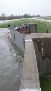
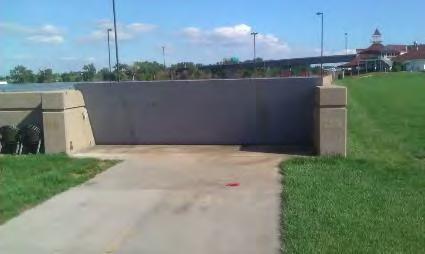
38 Documentation Document conditions in the field Flagging, stakes, paint Photos, videos, daily reports & checklists Proper handoff to next inspection team and upward reporting Ask for assistance 38


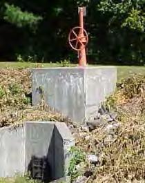
39 Staff Gages Is the water level going up or down? Gage 1 - Just Downstream of Highway 1 Bridge Date Time Reading 1-Apr 8: Water Level 1-Apr 12: Apr 16: Apr 20: Apr 0: Increasing 2-Apr 4: Apr 8: Apr 12: Apr 16: Apr 20: is at a gage reading of 85.7 Top of water at this location Decreasing 39
40 L-601 Missouri River Elevations Segment 1, June 19 40

41 Mobile Information Collection Application Flood surveillance Segment 1, June 19 41


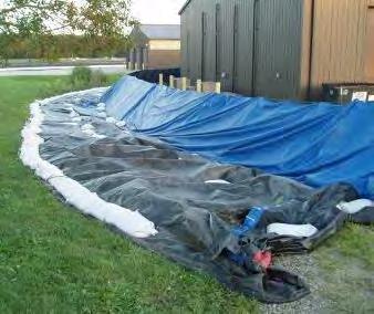
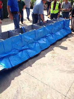
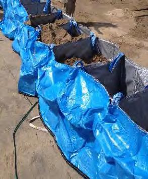
42 GPS Cell Phone Flood surveillance Segment 1, June 19 42

 Flowing")
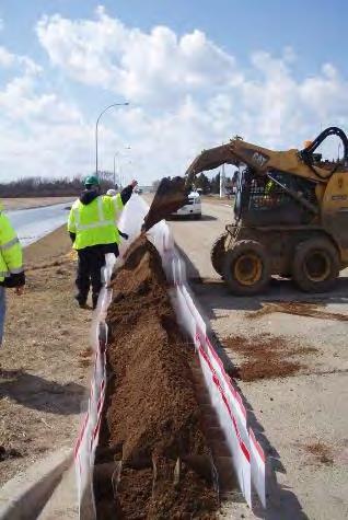
43 Flood Surveillance/Inspections Underseepage-Boils (Landside toe area primarily) Flowing clear or moving material? 43
44 Flood Surveillance/Inspections Slope Instability Cracking (Levee Crest Primarily) 44
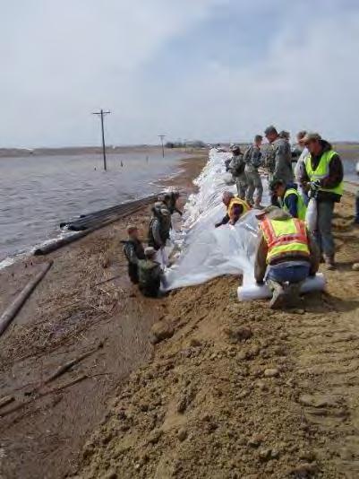
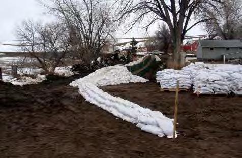
45 Flood Surveillance/Inspections Embankment Erosion 45
46 Flood Surveillance/Inspections Drainage structure, sewers, & other penetrations 46


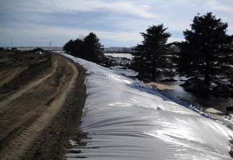
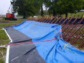
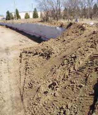
47 Flood Surveillance/Inspections Drainage structure, sewers, & other penetrations Emergency closure of culvert 47

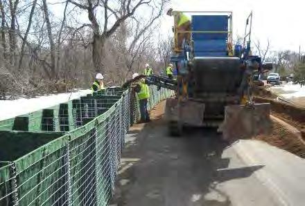
48 Flood Surveillance/Inspections Closure Structures When do you erect the closure? How long will it take? Is it functioning properly? 48


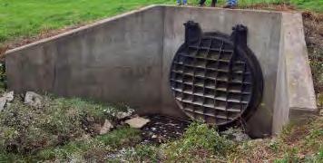
49 Flood Surveillance/Inspections Relief Wells Are they functioning? Irrigation Well 49
50 Flood Fighting Equipment Ryan Buckley Emergency Management February 2016 US Army Corps of Engineers
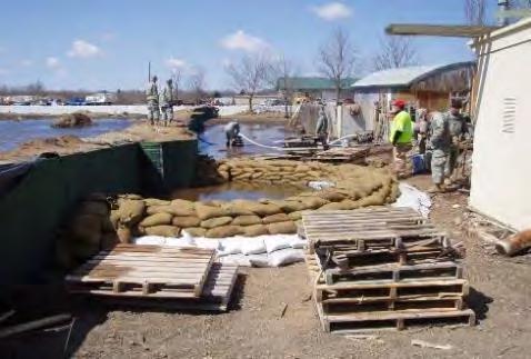
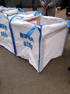
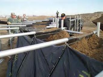
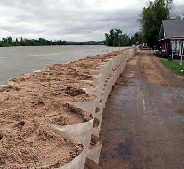
51 Flood Fighting What is the need and what are the options? Need Sand Boils/Seepage Closure Structures Levee Raise New levee segments Options Sandbags Earthen levees Innovative flood fight products HESCO Bastions RDFW Portadam Time & Place Each? How much lead time and available resources? 51


52 Sandbags HESCO Bastions Earthen Levee 52


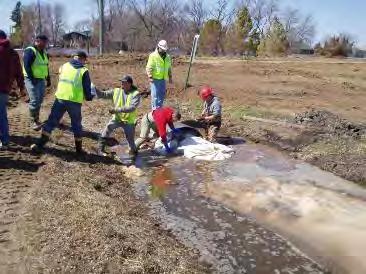
53 Ring boils if they are moving material Do not stop the water flow, it can cause the seepage path/boil to move Notice Anything? Treating Isolated Boils 53
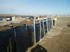
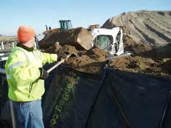
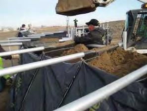
 Typical used for low/short barrier, transitions, constricted areas, closures & around sand boils")
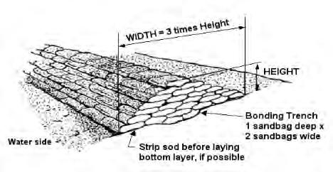
54 Sandbag Flood Structure USACE Recommendations 1V:3H (1 foot high for 3 foot width) 5 foot max (3 foot or less preferred) Typical used for low/short barrier, transitions, constricted areas, closures & around sand boils 54


55 Sandbag Flood Structure Direction of Flow 55


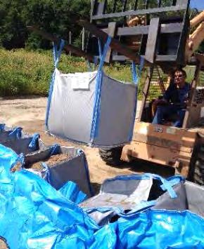
56 Sandbag Flood Structure Very labor intensive Filled sandbags must be kept from freezing prior to placement 56


57 Sandbag Flood Structure 57


58 Earthen Levees Notice anything? Notice anything? Why Plastic? 58


59 HESCO Bastion Structure 59


60 Rapid Deployable Flood Wall (RDFW) Structure 60


61 Portadam Structure 61

62 TopoTube 62


63 HESCO JackBox 63


64 Big Bags USA 64

65 TrapBag Structure 65

66 DefenCell 66


67 Combinations/Transitions RDFW to Earthen Levee RDFW & Sandbags Sandbags to Earthen Levee HESCO, RDFW & Sandbags Transition Concerns? 67

68 Flood Fight Supplies Sandbags throughout the District Super Sandbags Portadam RDFW Hesco Rolls of Poly Sandbag filling machines Trailer-mounted pumps 68

69 QUESTIONS? EmergencyManagement.aspx 69
Civil Engineer USACE, Omaha District. 28 February 2017 FLOOD FIGHTING AND SURVEILLANCE
 217 FLOOD FIGHTING AND SURVEILLANCE 237 200 237 217 200 Don Moses, 237 P.E. 217 200 Civil Engineer USACE, Omaha District 255 0 163 131 255 0 163 132 255 0 163 122 28 February 2017 239 65 53 80 119 27 110
Chapter A-9 GEOTECHNICAL ANALYSIS NORTH KANSAS CITY - LOWER (HARLEM AREA)
") Kansas Citys, Missouri and Kansas Flood Damage Reduction Feasibility Study (Section 216 Review of Completed Civil Works Projects) Engineering Appendix to the Interim Feasibility Report Chapter A-9 GEOTECHNICAL
Kansas Citys, Missouri and Kansas Flood Damage Reduction Feasibility Study (Section 216 Review of Completed Civil Works Projects) Engineering Appendix to the Interim Feasibility Report Chapter A-9 GEOTECHNICAL
Lesson 4: Flood Response Methods
 Lesson 4: Flood Response Methods In this lesson, you will learn the advantages and disadvantages of expedient flood works. Selecting the proper flood response technique is essential to the success of the
LOS ANGELES RIVER/RIO HONDO DIVERSION 2 LEVEE SYSTEM LOS ANGELES COUNTY, CALIFORNIA NLD SYSTEM ID #
 LOS ANGELES RIVER/RIO HONDO DIVERSION 2 LEVEE SYSTEM LOS ANGELES COUNTY, CALIFORNIA NLD SYSTEM ID # 3805010047 PERIODIC INSPECTION REPORT NO 1 GENERALIZED EXECUTIVE SUMMARY FINAL SYSTEM RATING: UNACCEPTABLE
UPPER MISSISSIPPI RIVER COMPREHENSIVE PLAN
 UPPER MISSISSIPPI RIVER COMPREHENSIVE PLAN APPENDIX D COST ESTIMATES Prepared by the U.S. Army Corps of Engineers Rock Island, St. Louis, and St. Paul Districts March 2008 UPPER MISSISSIPPI RIVER COMPREHENSIVE
SANTA ANA RIVER/ SAN TIMOTEO CREEK 1 LEVEE SYSTEM SAN BERNARDINO COUNTY, CALIFORNIA NLD SYSTEM ID #
 SANTA ANA RIVER/ SAN TIMOTEO CREEK 1 LEVEE SYSTEM SAN BERNARDINO COUNTY, CALIFORNIA NLD SYSTEM ID # 3805030015 PERIODIC INSPECTION REPORT NO. 1 GENERALIZED EXECUTIVE SUMMARY FINAL SYSTEM RATING: UNACCEPTABLE
Chapter A-8 GEOTECHNICAL ANALYSIS FAIRFAX-JERSEY CREEK (JERSEY CREEK SHEET PILE WALL)
") Kansas Citys, Missouri and Kansas Flood Damage Reduction Feasibility Study (Section 216 Review of Completed Civil Works Projects) Engineering Appendix to the Interim Feasibility Report Chapter A-8 GEOTECHNICAL
Kansas Citys, Missouri and Kansas Flood Damage Reduction Feasibility Study (Section 216 Review of Completed Civil Works Projects) Engineering Appendix to the Interim Feasibility Report Chapter A-8 GEOTECHNICAL
PAPERWORK REDUCTION ACT A. GENERAL
 U.S. DEPARTMENT OF HOMELAND SECURITY - FEDERAL EMERGENCY MANAGEMENT AGENCY RIVERINE STRUCTURES FORM O.M.B No. 1660-0016 Expires: 12/31/2010 PAPERWORK REDUCTION ACT Public reporting burden for this form
REVISED ETL Guidelines for Landscaping and Vegetation Management
 REVISED ETL 1110-2-571 Guidelines for Landscaping and Vegetation Management Paige Caldwell, P.E. Emergency Manager Overview Policy revision process Key points from the ETL guidance Illustrations of acceptable
Lower San Joaquin River Feasibility Study PLAN FORMULATION ADDENDUM
 PLAN FORMULATION ADDENDUM Non-Structural Measure Descriptions Elevate Critical Infrastructure This measure would raise at-risk critical structures above the design inundation level. Elevation would be
THREE RIVERS LEVEE IMPROVEMENT AUTHORITY 1114 Yuba Street, Suite 218 Marysville, CA Office (530) Fax (530)
 Fax (530)") THREE RIVERS LEVEE IMPROVEMENT AUTHORITY 1114 Yuba Street, Suite 218 Marysville, CA 95901 Office (530) 749-7841 Fax (530) 749-6990 November 20, 2013 Mr. Eric Simmons Regional Engineer, FEMA Region IX 1111
THREE RIVERS LEVEE IMPROVEMENT AUTHORITY 1114 Yuba Street, Suite 218 Marysville, CA 95901 Office (530) 749-7841 Fax (530) 749-6990 November 20, 2013 Mr. Eric Simmons Regional Engineer, FEMA Region IX 1111
Data Collection Report draft
 Data Collection Report draft City of Houston, Minnesota Houston Levee Certification Phase I Report prepared by June 2, 2015 DATA COLLECTION REPORT PHASE I DATA COLLECTION AND REVIEW HOUSTON LEVEE CERTIFICATION
Types of Inspections. Prior to Inspection. Types of Inspections. Typical Inspection Equipment. Embankment Dams
 BIA Summer Water Resources Training Dam Safety Inspections Part 4 - Inspections July 28, 2012 Presented by Michael Johnson, Ph.D., P.E. Types of Inspections Periodic Inspections A comprehensive visual
Peninsula Drainage District #2 Encroachment Evaluation Summary Report
 Peninsula Drainage District #2 Encroachment Evaluation Summary Report Levee Ready Columbia / Peninsula Drainage District #2 / 1880 NE Elrod Drive, Portland, Oregon 97211 Table of Contents Contents Summary...
Chapter A-15. CID-MO Structural Analysis
 Kansas Citys, Missouri and Kansas Flood Risk Management Feasibility Study Engineering Appendix to the Final Feasibility Study Chapter A-15 CID-MO Structural Analysis Chapter A-15 CID-MO Structural Analysis
FEMA Levee Certification Ventura County, California
 Ventura County Watershed Protection District FEMA Levee Certification Ventura County, California Ventura River Levee (VR-1) Pacific Ocean to Canada de San Joaquin Evaluation Report February 20, 2009 TETRA
Technical Memorandum Channel Capacity Report 2018 Restoration Year
 Technical Memorandum Channel Capacity Report 2018 Restoration Year 1 Table of Contents 2 1.0 Executive Summary... ES-1 3 4 2.0 Introduction... 1 5 2.1 Objective... 2 6 2.2 CCAG Roles and Responsibilities...
Dam Safety Inspection Checklist
 Dam Safety Inspection Checklist Complete All Portions of This Section (Pre-inspection) Date of Inspection: Name of Dam: EAP: (yes, no) OM&I: (yes, no) File Number: Review Inventory - Highlight missing
SAN GABRIEL RIVER/ COYOTE CREEK 2 LEVEE SYSTEM LOS ANGELES COUNTY, CALIFORNIA NLD SYSTEM ID #
 SAN GABRIEL RIVER/ COYOTE CREEK 2 LEVEE SYSTEM LOS ANGELES COUNTY, CALIFORNIA NLD SYSTEM ID # 3805010031 PERIODIC INSPECTION REPORT NO. 2 GENERALIZED EXECUTIVE SUMMARY FINAL SYSTEM RATING: MINIMALLY ACCEPTABLE
Manure Storage for Environmental Management Systems
 WiMStor01 MStor Manure Storage for Environmental Management Systems Key: 1)Low Risk 2)Low-Moderate Risk 3)Moderate-High Risk 4)High Risk Location of Manure Storage Are the manure storage facilities in
Temporary Watercourse Crossing: Culverts
 Temporary Watercourse Crossing: Culverts DRAINAGE CONTROL TECHNIQUE Low Gradient Velocity Control Short Term Steep Gradient Channel Lining Medium-Long Term Outlet Control Soil Treatment Permanent Symbol
APPENDIX A EARTHEN EMBANKMENT. VERSION 1.0 March 1, 2011
 APPENDIX A EARTHEN EMBANKMENT VERSION 1.0 March 1, 2011 SECTION A-1: DESCRIPTION OF PRACTICE An earthen embankment is a raised impounding structure made from compacted soil. The embankment is the feature
DTE Energy St. Clair Power Plant
 DTE Energy St. Clair Power Plant Unit 6 Scrubber Basins CCR Rule Compliance Project Annual Inspection Report - 2017 Project Number: 60546402 June 30, 2017 Prepared by: 27777 Franklin Road, Suite 2000 Southfield,
LEVEE DEFICIENCY CORRECTION PROCEDURES
 LEVEE DEFICIENCY CORRECTION PROCEDURES USACE, LOS ANGELES DISTRICT 24 APRIL 2015 LEVEE SAFETY PROGRAM Deficiencies noted on the inspection checklist portion of the Periodic Inspection Report shall be addressed
Central Region GeoHazard Assessment H597:02, km Slide May 2011 Site Inspection and Instrumentation Monitoring Report
 Alberta Transportation Central Region #401, 4902 51 Street Red Deer, Alberta T4N 6K8 July 14, 2011 Mr. Dennis Grace, P.Eng. Construction Engineer Dear Mr. Grace: Central Region GeoHazard Assessment H597:02,
Lyon Creek Cedar Way Stormwater Detention Dam Operation and Maintenance Manual
 Lyon Creek Cedar Way Stormwater Detention Dam Operation and Maintenance Manual Prepared by: Mike Shaw Stormwater Program Manager City of Mountlake Terrace January 2010 Section I General Information This
APPENDIX A. Project Scoping
 APPENDIX A Project Scoping Notice of Preparation To: From: Agencies and Interested Parties Paul Brunner, Executive Director, Three Rivers Levee Improvement Authority Date: June 13, 2006 Subject: Notice
NOTICE OF PREPARATION
 NOTICE OF PREPARATION Date: June 12, 2014 To: From: Subject: Governor s Office of Planning and Research/State Clearinghouse Unit, Responsible Agencies, Trustee Agencies, and Interested Parties Announcement
Highway Drainage 1- Storm Frequency and Runoff 1.1- Runoff Determination
 Highway Drainage Proper drainage is a very important consideration in design of a highway. Inadequate drainage facilities can lead to premature deterioration of the highway and the development of adverse
TxDOT Houston District Permit Requirements (Information contained herein is subject to change)
") Houston District Permit Requirements (Information contained herein is subject to change) Access Driveway for Commercial / Industrial Developments; or Street Tie-In / Drainage-Only 1) Complete the three
Houston District Permit Requirements (Information contained herein is subject to change) Access Driveway for Commercial / Industrial Developments; or Street Tie-In / Drainage-Only 1) Complete the three
Construction Inspection Checklists
 III. Construction Inspection Checklists 33 Bioretention - Construction Inspection Checklist Project: Location: Site Status: Date: Time: Inspector: Construction Sequence Satisfactory / Unsatisfactory Comments
2017 Annual Dam and Dike Inspection Report
 2017 Annual Dam and Dike Inspection Report Bottom Ash Pond Complex Mitchell Plant Wheeling Power Company & Kentucky Power Company Marshall County, West Virginia October 20, 2017 Prepared by: American Electric
9. Levee Maintaining Agency Projects
 9. Levee Maintaining Agency Projects 9.1. Overview This chapter summarizes the known deficiencies identified for each local levee maintaining agency (LMA) within the Regions. Note that although the focus
FEMA and Levees Levee Accreditation Reviews Proposed Changes to the FEMA Levee Policy
 Agenda FEMA and Levees Levee Accreditation Reviews Proposed Changes to the FEMA Levee Policy Page 2 FEMA and Levees FEMA and Levees FEMA does NOT own or operate any levees Establishment of appropriate
Chapter 11 Culverts and Bridges
 Chapter 11 Culverts and Bridges Contents 1.0 Introduction... 1 2.0 General Design... 1 2.1 Design Criteria... 1 2.2 Design Flows... 1 2.3 Permitting and Regulations... 1 2.4 Aesthetics and Safety... 2
ERDC/GSL TN-14-2 August 2014 Review of Instrumentation and Monitoring for USACE Levees
 Review of Instrumentation and Monitoring for USACE Levees By Joseph B. Dunbar, Gustavo Galan-Comas, Lucas A. Walshire, Ronald E. Wahl, Donald Yule, Maureen K. Corcoran, Jose Llopis, and Amber L. Bufkin
Table of Contents. Attachments Attachment A Photos Attachment B Site Map. Pages 3 of 9
 Table of Contents 1.0 Introduction...4 2.0 Description of Landfill...4 3.0 Review of Available Information...5 4.0 Inspection...5 4.1 Changes in Geometry since Last Inspection...5 4.2 Volume...5 4.3 Definitions
ENGINEERING REPORT ANALYSIS OF CLOSURES. HOUSATONIC RIVER and NAUGATUCK RIVER FLOOD PROTECTION PROJECTS SECTION 1. ANSONIA and DERBY, CONNECTICUT
 ENGINEERING REPORT ANALYSIS OF CLOSURES HOUSATONIC RIVER and NAUGATUCK RIVER FLOOD PROTECTION PROJECTS SECTION 1 ANSONIA and DERBY, CONNECTICUT December 2010 MMI #1560-119 and #3118-03 Prepared for: City
NEW CASTLE CONSERVATION DISTRICT. through. (Name of Municipality) PLAN REVIEW APPLICATION DRAINAGE, STORMWATER MANAGEMENT, EROSION & SEDIMENT CONTROL
 PLAN REVIEW APPLICATION DRAINAGE, STORMWATER MANAGEMENT, EROSION & SEDIMENT CONTROL") NEW CASTLE CONSERVATION DISTRICT through (Name of Municipality) PLAN REVIEW APPLICATION DRAINAGE, STORMWATER MANAGEMENT, EROSION & SEDIMENT CONTROL Office use only: Received by Municipality: Received by
NEW CASTLE CONSERVATION DISTRICT through (Name of Municipality) PLAN REVIEW APPLICATION DRAINAGE, STORMWATER MANAGEMENT, EROSION & SEDIMENT CONTROL Office use only: Received by Municipality: Received by
An Introduction to Seepage, Slope and Settlement of Levees
 An Introduction to Seepage, Slope and Settlement of Levees Course No: G02-011 Credit: 2 PDH J. Paul Guyer, P.E., R.A., Fellow ASCE, Fellow AEI Continuing Education and Development, Inc. 9 Greyridge Farm
Created by Simpo PDF Creator Pro (unregistered version) Asst.Prof.Dr. Jaafar S. Maatooq
 Asst.Prof.Dr. Jaafar S. Maatooq") Lect.No.9 2 nd Semester Barrages, Regulators, Dams 1 of 15 In order to harness the water potential of a river optimally, it is necessary to construct two types of hydraulic structures, as shown in Figure
Lect.No.9 2 nd Semester Barrages, Regulators, Dams 1 of 15 In order to harness the water potential of a river optimally, it is necessary to construct two types of hydraulic structures, as shown in Figure
2017 ANNUAL DAM AND DIKE INSPECTION REPORT
 2017 ANNUAL DAM AND DIKE INSPECTION REPORT ASH PONDS WELSH POWER PLANT CASON, TEXAS November, 2017 Prepared by: American Electric Power Service Corporation 1 Riverside Plaza Columbus, OH 43215 GERS-17-067
AMERICAN ELECTRIC POWER (SWEPCO)
") 2015 DAM & DIKE INSPECTION REPORT ASH PONDS GERS-15-034 WELSH POWER PLANT AMERICAN ELECTRIC POWER (SWEPCO) CASON, TEXAS NATIONAL INVENTORY NO. TX4357 PREPARED BY GEOTECHNICAL ENGINEERING AEP SERVICE CORPORATION
2015 DAM & DIKE INSPECTION REPORT ASH PONDS GERS-15-034 WELSH POWER PLANT AMERICAN ELECTRIC POWER (SWEPCO) CASON, TEXAS NATIONAL INVENTORY NO. TX4357 PREPARED BY GEOTECHNICAL ENGINEERING AEP SERVICE CORPORATION
Annual Inspection Report
 Annual Inspection Report J.C. WEADOCK GENERATING FACILITY DRY ASH LANDFILL 2016 CCR LANDFILL INSPECTION REPORT Essexville, Michigan Pursuant to 40 CFR 257.84 Submitted To: Consumers Energy Company 1945
The Good, The Bad, and The Ugly
 Overview The Good, The Bad, and The Ugly Stormwater Regulations for the Construction Industry Seminar March 20, 2012 Wendy Terlizzi Arizona Department of Transportation Office of Environmental Services
PLANNING FOR LEVEE BREACH IN DUBUQUE, IA: MODELING & DEVELOPMENT OF MITIGATION STRATEGIES
 PLANNING FOR LEVEE BREACH IN DUBUQUE, IA: MODELING & DEVELOPMENT OF MITIGATION STRATEGIES Andy McCoy, PhD, PE 2014 HDR, Inc., all rights reserved. INTRODUCTION A LOOK BACK - LEVEE BREACH IN DES MOINES,
Visual Inspection Checklist
 APPENDIX Q. Visual Inspection Checklist Thispageintentionallyleftblank. VISUAL INSPECTION CHECKLIST CITY OF AUBURN PUBLIC WORKS DEPARTMENT INSPECTION YEAR: TYPE OF INSPECTION: (Informal, Regular, Formal):
SLURRY WALLS FOR SEEPAGE CUTOFF IN LEVEE APPLICATIONS RECENT EXPERIENCE AND CONSTRUCTION CHALLENGES IN THE NORTHERN CENTRAL VALLEY OF CALIFORNIA
 SLURRY WALLS FOR SEEPAGE CUTOFF IN LEVEE APPLICATIONS RECENT EXPERIENCE AND CONSTRUCTION CHALLENGES IN THE NORTHERN CENTRAL VALLEY OF CALIFORNIA Deep Foundation Institute Slurry Wall Committee July 22,
Port of Camas/Washougal Levee Recertification and Engineering Analysis Request for Proposal May 3, 2011
 I. Project Summary As part of their Map Modernization Program, FEMA has initiated a countywide Flood Insurance Study (FIS) and Digital Flood Insurance Rate Map (DFIRM) for the Port of Camas/Washougal.
LEVEE DEFICIENCY CORRECTION PROCEDURES
 LEVEE DEFICIENCY CORRECTION PROCEDURES USACE, LOS ANGELES DISTRICT 26 JANUARY 2016 LEVEE SAFETY PROGRAM Revised 26 MARCH 2018 Deficiencies noted on the inspection checklist portion of the Periodic Inspection
River management in Japan With focus on river levee
 River management in Japan With focus on river levee January 2009 Masahiro Atsumi River Bureau, Ministry of Land, Infrastructure, Transport and Tourism, Japan Objectives of river management Article 1 of
Association of State Floodplain Managers May 2, 2017 Rob Davis, P.E., ENVSP Flood Control System Program Manager
 Association of State Floodplain Managers May 2, 2017 Rob Davis, P.E., ENVSP Flood Control System Program Manager 2008 vs. 2016 Cedar Rapids Population 130,000 Second largest city in Iowa Industrial roots:
MAINE TURNPIKE AUTHORITY ADDENDUM NO. 1 CONTRACT EXIT 103 SOUTHBOUND UNDERPASS BRIDGE REHABILITATION MILE 103.0
 MAINE TURNPIKE AUTHORITY ADDENDUM NO. 1 CONTRACT 2018.05 EXIT 103 SOUTHBOUND UNDERPASS BRIDGE REHABILITATION MILE 103.0 The bid opening date is Thursday March 15, 2018 at 11:00 a.m. The following changes
Flood & Storm Water Emergency Scope of Services
 Flood & Storm Water Emergency Scope of Services EMERGENCY CONTACTS: CHRIS DELLARINGA CELL: 916-340-5600 EMAIL: CHRIS@BLUEIRONINC.COM MELISSA BAKER CELL: 916-825-8261 EMAIL MELISSA@BLUEIRONINC.COM Flood
Modeling a Complex Hydraulic Environment Using a 1-D Approach Supplemented with Simple 2-D Principles Manas Borah Ed Dickson June 5, 2014
 ASFPM 2014 Annual Conference Modeling a Complex Hydraulic Environment Using a 1-D Approach Supplemented with Simple 2-D Principles Manas Borah Ed Dickson June 5, 2014 Agenda Overview and Background Hydrology
Supplemental Watershed Plan Agreement No. 10 for Neshaminy Creek Watershed Core Creek Dam (PA-620) Bucks County, Pennsylvania
 Bucks County, Pennsylvania") Supplemental Watershed Plan Agreement No. 10 for Neshaminy Creek Watershed Core Creek Dam (PA-620) Bucks County, Pennsylvania Project Authorization USDA's Small Watershed Program is carried out under the
Supplemental Watershed Plan Agreement No. 10 for Neshaminy Creek Watershed Core Creek Dam (PA-620) Bucks County, Pennsylvania Project Authorization USDA's Small Watershed Program is carried out under the
SECTION 11: REGULATORY FLOODWAYS
 SECTION 11: REGULATORY FLOODWAYS Contents 11.1. The Floodway... 11-2 11.1.1. The floodway concept... 11-2 11.1.2. Floodway map... 11-2 11.1.3. Floodway permitting... 11-3 11.1.4. Changing the floodway...
MAMMAL BURROW CHARACTERIZATION AND EFFECTIVENESS OF BURROW GROUTING
 MAMMAL BURROW CHARACTERIZATION AND EFFECTIVENESS OF BURROW GROUTING Diego Cobos, Michelle Shriro, Nicholas Sitar, Jonathan Bray University of California, Berkeley 1 INTRODUCTION Mammal burrowing activity
Coal Combustion Facility Assessment Report. October 20, 2010
 Coal Combustion Facility Assessment Report October 20, 2010 Introduction Stantec Consulting Services Inc. North American Consulting Firm 10,000 Engineers, Geologists, Architects, Scientists and Technicians
Lessons [being] learnt 2016 Flood in Cedar Rapids. Sandy Pumphrey Project Engineer II Flood Mitigation
![Lessons [being] learnt 2016 Flood in Cedar Rapids. Sandy Pumphrey Project Engineer II Flood Mitigation](/thumbs/77/74998790.jpg "Lessons [being] learnt 2016 Flood in Cedar Rapids. Sandy Pumphrey Project Engineer II Flood Mitigation") Lessons [being] learnt 2016 Flood in Cedar Rapids Sandy Pumphrey Project Engineer II Flood Mitigation 319 286 5363 s.pumphrey@cedar-rapids.org Agenda 2008 Flood Event 2016 Flood Event [Long Term] Flood
Lessons [being] learnt 2016 Flood in Cedar Rapids Sandy Pumphrey Project Engineer II Flood Mitigation 319 286 5363 s.pumphrey@cedar-rapids.org Agenda 2008 Flood Event 2016 Flood Event [Long Term] Flood
Public Sponsor Representative Name Organization Team
 Public Sponsor Representative Name Organization Team Dan Repay LCRBDC Rick Konopasek Town of Griffith Levee Jeff essinio Town of Griffith Levee Wenchao Lu Garcia Consulting Engineers Sluice Gates Jeff
REROUTING DRAINAGE SYSTEMS
 MINNESOTA WETLAND RESTORATION GUIDE REROUTING DRAINAGE SYSTEMS TECHNICAL GUIDANCE DOCUMENT Document No.: WRG 4A-4 Publication Date: 10/14/2015 Table of Contents Introduction Application Design Considerations
Factors affecting health of Ash Dyke and Preventive Measures. Kukreti RC Chowdhury Ujjwal Naresh D N
 Factors affecting health of Ash Dyke and Preventive Measures Kukreti RC Chowdhury Ujjwal Naresh D N 1 1 ENVIRONMENTAL REGULATIONS Before any construction activity - MOEF clearance is a must MOEF stipulation
Flood Hazard Assessment Report Falls Gulch, Larimer County, Colorado January 16, 2013
 United States Department of Agriculture Natural Resources Conservation Service Denver Federal Center Building 56, Room 2604 P.O. Box 25426 Denver, CO 80225 720-544-2818-OFFICE alton.albin@co.usda.gov Flood
2016 Annual Dam and Dike Inspection Report
 2016 Annual Dam and Dike Inspection Report Fly Ash Pond John E. Amos Plant Appalachian Power Co. Putnam County, West Virginia November, 2016 Prepared for: Appalachian Power Co. 1530 Winfield Rd Winfield,
CITY UTILITIES DESIGN STANDARDS MANUAL
 CITY UTILITIES DESIGN STANDARDS MANUAL () September 2017 Page Chapter 1 Acronyms and Definitions 1.01 Purpose 1 1.02 Acronyms 1 1.03 Definitions 3 Chapter 2 Introduction 2.01 Purpose 1 2.02 Applicability
Ponds. Pond A water impoundment made by excavating a pit, or constructing a dam or an embankment.
 POND SITE SELECTION AND CONSTRUCTION Uses, Planning, & Design David Krietemeyer Area Engineer USDA-NRCS June 20, 2008 Uses Considerations for Location of Commonly Used Terms Pond A water impoundment made
STREAM STABILIZATION PLAN
 DISTRICT COUNTY ROUTE SECTION SHEET 6- PHILADELPHIA 47 14B 1 OF 2 NOTES: REVISION NUMBER REVISIONS DATE BY 1. REFER TO EROSION AND SEDIMENT POLLUTION CONTROL PLANS FOR LOCATION OF TEMPORARY CONSTRUCTION
Open Trench Construction Plan Review The open trench construction plan review involves the following general investigative elements:
 TNC Fisher Slough Final Design and Permitting Subject: Inverted Siphon Construction Feasibility To: From: Jenny Baker (TNC) Dave Olson (DD3) Brian Olson (DD17) Bob Boudinot Skagit County David Cline (Tetra
Storm Drain Inlet Protection
 Categories EC Erosion Control SE Sediment Control TC Tracking Control WE Wind Erosion Control Non-Stormwater NS Management Control Waste Management and WM Materials Pollution Control Legend: Primary Category
Design of Earthen Tanks Booklet No. 574 Soil and Water Conservation: SWCS - 574
 Contents Preface I. Introduction II. III. Design of Earthen Tanks Booklet No. 574 Soil and Water Conservation: SWCS - 574 General Consideration Components of a Dam IV. Design of Other Type of Dams V. Estimation
Old Mill School Stream Restoration
 Project Overview This conceptual plan restores and stabilizes two consecutive reaches of a highly incised and unstable stream and reconnects them with the floodplain. The restoration reaches are part of
ROLES AND RESPONSIBILITIES Small Pond Approval. SWM MD-378 Pond Checklist Training 10/17/07. Exemptions EMBANKMENT HEIGHT. Height of Dam Weir Wall
 SWM MD-378 Pond Checklist Training 10/17/07 Ken Wolfe Warren Johnson USDA, NRCS Frederick, Maryland ROLES AND RESPONSIBILITIES Small Pond Approval MDE, WMA, Dam Safety Division Authority (COMAR 26.17.04.03)
Proper Construction of detention and sediment basins and their conversions
 Proper Construction of detention and sediment basins and their conversions By Chris Droste, CESCO Senior Erosion Control Specialist Westmoreland Conservation District Discussed topics Pond embankment construction
Holly Swartz and Jason Shirey
 Chapter 105 General Permits for Stream and Wetland Impacts DEP Ch. 105 CONTACTS FOR BERKS COUNTY: Holly Swartz and Jason Shirey What DEP Regulates Under Chapter 105 Waters of the Commonwealth, which includes
Flow Control No Channel Flow Dry Channels Erosion Control Low Channel Flows Shallow Water Sediment Control High Channel Flows [1] Deep Water [2]
![Flow Control No Channel Flow Dry Channels Erosion Control Low Channel Flows Shallow Water Sediment Control High Channel Flows [1] Deep Water [2]](/thumbs/78/76959611.jpg "Flow Control No Channel Flow Dry Channels Erosion Control Low Channel Flows Shallow Water Sediment Control High Channel Flows [1] Deep Water [2]") Geo Logs (coir logs) INSTREAM PRACTICES Flow Control No Channel Flow Dry Channels Erosion Control Low Channel Flows Shallow Water Sediment Control High Channel Flows [1] Deep Water [2] [1] Geo logs can
Geo Logs (coir logs) INSTREAM PRACTICES Flow Control No Channel Flow Dry Channels Erosion Control Low Channel Flows Shallow Water Sediment Control High Channel Flows [1] Deep Water [2] [1] Geo logs can
Closure/Post-Closure Care Plan Unit 3 AQCS Solids Landfill
 Sherburne County Generating Plant MPCA Permit No. SW-293 Becker, MN Table of Contents Page 1.0 Introduction...1 2.0 Closure Plan...2 2.1 Notification of Final Cover Construction...2 2.2 Notification of
MAINE TURNPIKE AUTHORITY ADDENDUM NO. 2 CONTRACT EXIT 44 SOUTHBOUND ON RAMP IMPROVEMENTS MILE 44.3
 MAINE TURNPIKE AUTHORITY ADDENDUM NO. 2 CONTRACT 2018.03 EXIT 44 SOUTHBOUND ON RAMP IMPROVEMENTS MILE 44.3 The following changes are made to the Proposal, Specifications, and Plans. PROPOSAL Proposal Sheets
Herbert Hoover Dike (HHD), Florida Major Rehabilitation Project. The Challenges and Opportunities of Managing a Large Program NCER July 22, 2009
, Florida Major Rehabilitation Project. The Challenges and Opportunities of Managing a Large Program NCER July 22, 2009") Herbert Hoover Dike (HHD), Florida Major Rehabilitation Project The Challenges and Opportunities of Managing a Large Program NCER July 22, 2009 Mike Rogalski, P.E. Chief, HHD Project Branch Presentation
Herbert Hoover Dike (HHD), Florida Major Rehabilitation Project The Challenges and Opportunities of Managing a Large Program NCER July 22, 2009 Mike Rogalski, P.E. Chief, HHD Project Branch Presentation
Prepared for Urban Drainage and Flood Control District
 BERM FAILURE TECHNICAL ANALYSES SOUTH PLATTE GRAVEL PIT EVALUATION CRITERIA Prepared for Urban Drainage and Flood Control District Wright Water Engineers, Inc. January 2013 121-030.000 TABLE OF CONTENTS
APPENDIX A HYDROLOGIC AND HYDRAULIC ANALYSIS
 APPENDIX A HYDROLOGIC AND HYDRAULIC ANALYSIS GENERAL The Hydrologic and Hydraulic information presented in this appendix is provided as a supplement to the Dallas Floodway Extension General Re-evaluation
POND CONSTRUCTION. Woodland Steward Series
 POND CONSTRUCTION Woodland Steward Series BOB TWOMEY DISTRICT CONSERVATIONIST USDA NATURAL RESOURCES CONSERVATION SERVICE COURSE OUTLINE DEFINITION OF A POND OR LAKE TYPES OF PONDS GEOLOGIC CONSIDERATIONS
United States Army Corps of Engineers. Addicks and Barker Dam Safety Update
 United States Army Corps of Engineers Addicks and Barker Dam Safety Update COL Richard P. Pannell District Commander, Galveston District U.S. Army Corps of Engineers March 9, 2016 US Army Corps of Engineers
PRELIMINARY DRAINAGE REPORT NEWCASTLE FIRE STATION OLD STATE HIGHWAY
 PRELIMINARY DRAINAGE REPORT FOR THE NEWCASTLE FIRE STATION OLD STATE HIGHWAY PREPARED FOR THE NEWCASTLE FIRE PROTECTION DISTRICT JULY 2014 BY ROSEVILLE DESIGN GROUP, INC. ROSEVILLE DESIGN GROUP, Inc Established
ENGINEERING CHECKLIST SEDIMENT & STORMWATER MANAGEMENT BASIN CONSTRUCTION
 NEW CASTLE COUNTY DEPARTMENT OF LAND USE ENGINEERING CHECKLIST SEDIMENT & STORMWATER MANAGEMENT BASIN CONSTRUCTION For Permanent Structures, pursuant to Delaware Pond Code 378 and Delaware Sediment and
Jacobi, Toombs, and Lanz, Inc.
 Area 5: Blackiston Mill Road at Dead Man's Hollow Flooding Assessment Jacobi, Toombs, and Lanz, Inc. This document summarizes an assessment of drainage and flooding concerns and provides recommendations
Freight Street Development Strategy
 Freight Street Development Strategy Appendix B: Naugatuck River Floodplain Analysis Freight Street Development Strategy DECEMBER 2017 Page B-1 1.0 NAUGATUCK RIVER FLOODPLAIN AT FREIGHT STREET 1.1 Watershed
SMART GYPSUM STACK MANAGEMENT FROM CONCEPT TO REALITY
 SMART GYPSUM STACK MANAGEMENT FROM CONCEPT TO REALITY Phong Vo, Manager - Engineering/Gypsum, Mosaic Fertilizer, LLC. 13830 Circa Crossing Drive Lithia, Florida 33547, USA and Ashraf H. Riad, Ph.D., P.E.,
POST CLOSURE PLAN. CFR (d) GERS Landfill. Pirkey Plant Hallsville, Texas. October, 2016
 GERS Landfill. Pirkey Plant Hallsville, Texas. October, 2016") POST CLOSURE PLAN CFR 257.104(d) Landfill Pirkey Plant Hallsville, Texas October, 2016 Prepared for : Southwest Electric Power Company Pirkey Power Plant Hallsville, Texas Prepared by: American Electric
POST CLOSURE PLAN CFR 257.104(d) Landfill Pirkey Plant Hallsville, Texas October, 2016 Prepared for : Southwest Electric Power Company Pirkey Power Plant Hallsville, Texas Prepared by: American Electric
ENGINEERING AND CONSTRUCTION BULLETIN
 ENGINEERING AND CONSTRUCTION BULLETIN No. 2017-15 Issuing Office: CECW-CE Issued: 14 Jul 17 Expires: 14 Jul 19 SUBJECT: Managed Overtopping of Levee Systems CATEGORY: Guidance APPLICABILITY: The U.S. Army
AGRICULTURAL DRAINAGE
 AGRICULTURAL DRAINAGE ARCHITECTURE + ENGINEERING + ENVIRONMENTAL + PLANNING True Expertise + Sustainable Solutions Facing the Challenges Together With over 40 years of experience, ISG is focused on improving
Short List of Projects No. PROJECT
 Short List of Projects No. PROJECT 1 Smith Canal Closure Structure 2 RD 17 Levee Strengthening 3 Paradise Cut Improvements (Base Case) 4 Tentatively Selected Plan from the Lower San Joaquin Feasibility
Table of Contents. Attachments Attachment A Photos Attachment B Inspection Map. Pages 3 of 10
 Table of Contents 1.0 Introduction...4 2.0 Description of Landfill...4 3.0 Review of Available Information...5 4.0 Inspection...5 4.1 Changes in Geometry since Last Inspection...5 4.2 Volume...5 4.3 Definitions
10.1 INTRODUCTION 10.1 DRAINAGE
 CHAPTER 10 DRAINAGE 10.1 INTRODUCTION The drainage system manages both surface and subsurface water coming off the road surface and from the surrounding countryside. The purpose of the system is to ensure
Muskeg River Mine Dedicated Disposal Area (DDA) Plan for In-pit Cell 1
 Plan for In-pit Cell 1") Muskeg River Mine Dedicated Disposal Area (DDA) Plan for In-pit Cell 1 Updated: November 2010 Directive 74 Appendix C Requirement Approval: 8512D Submitted to SHELL CANADA ENERGY MRM DDA PLAN-UPDATE NOV
Muskeg River Mine Dedicated Disposal Area (DDA) Plan for In-pit Cell 1 Updated: November 2010 Directive 74 Appendix C Requirement Approval: 8512D Submitted to SHELL CANADA ENERGY MRM DDA PLAN-UPDATE NOV
q Item meets standard Project ID: X Item not acceptable Contractor: N/A Item not applicable Inspector: C Item requires engineer s cert.
 SEDIMENT/STORMWATER MANAGEMENT BASIN CONSTRUCTION CHECKLIST For permanent structures per Delaware SCS Pond Code 378 and Delaware Sediment and Stormwater Regulations KEY PROJECT INFORMATION q Item meets
INFLOW DESIGN FLOOD CONTROL SYSTEM PLAN 40 C.F.R. PART PLANT YATES ASH POND 3 (AP-3) GEORGIA POWER COMPANY
 GEORGIA POWER COMPANY") INFLOW DESIGN FLOOD CONTROL SYSTEM PLAN 40 C.F.R. PART 257.82 PLANT YATES ASH POND 3 (AP-3) GEORGIA POWER COMPANY EPA s Disposal of Coal Combustion Residuals from Electric Utilities Final Rule (40 C.F.R.
INFLOW DESIGN FLOOD CONTROL SYSTEM PLAN 40 C.F.R. PART 257.82 PLANT YATES ASH POND 3 (AP-3) GEORGIA POWER COMPANY EPA s Disposal of Coal Combustion Residuals from Electric Utilities Final Rule (40 C.F.R.
Filter Tube Barriers (Instream)
") Filter Tube Barriers (Instream) INSTREAM PRACTICES Flow Control No Channel Flow Dry Channels Erosion Control Low Channel Flows Shallow Water Sediment Control High Channel Flows Deep Water Symbol Photo
Filter Tube Barriers (Instream) INSTREAM PRACTICES Flow Control No Channel Flow Dry Channels Erosion Control Low Channel Flows Shallow Water Sediment Control High Channel Flows Deep Water Symbol Photo
Section 401. PIPE CULVERTS
 401.02 Section 401. PIPE CULVERTS 401.01. Description. This work consists of constructing pipe culverts of the size and class required, including excavation and backfill. 401.02. Materials. Provide materials