Office of Transportation Data (OTD)
|
|
|
- Alyson Merritt
- 5 years ago
- Views:
Transcription

1 Office of Transportation Data (OTD) Paul Tanner State Transp o rtatio n D ata A d m inistrato r
2 Presentation Objectives Why do we collect data? State & Federal Code Requirements Who collects the data? OTD s Primary Business Groups What are our products? Top 10 OTD Products How do we ensure we meet business needs? Quality Assurance and Customer Service
3 State Code Requirements Classification of public roads The public roads of Georgia shall be divided and classified in accordance with the three types of classifications provided in this Code section: State highway system, County road systems, Municipal street systems Official map, list, and records; rules and regulations The department shall prepare an official map showing all public roads on the state highway system. The department shall also prepare and distribute to each county a map showing all the public roads on its county road system including extensions into municipalities.
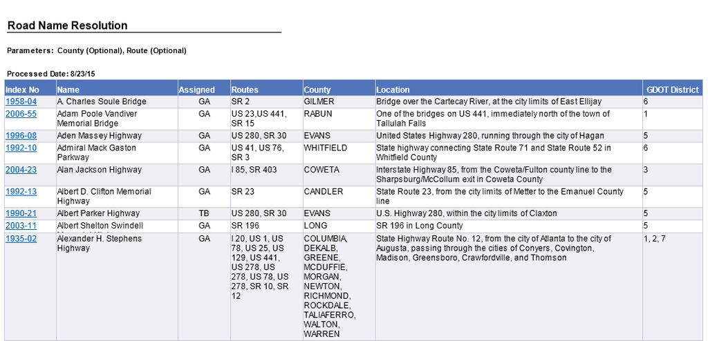
4 State Code Requirements (Cont.) Official map, list, and records; rules and regulations (cont.) The department shall prepare an official list of all portions or features of the state highway system, including without limitation public roads, bridges, or interchanges, which have been named by Act or resolution of the General Assembly or by resolution of the State Transportation Board. The department shall keep written records of the mileage on all public roads on the state highway system and on all public roads on each of the county road systems.
5 State Code Requirements (Cont.) Duties (of a County) The county shall notify the department within three months after a county road is added to the local road or street system and shall further notify the department within three months after a local road or street has been abandoned Duties (of a municipality) A municipality shall notify the department within three months after a municipal street is added to the municipal street system and shall further notify the department within three months after a municipal street is abandoned.
6 Federal Code Requirements United States Code of Federal Regulations (CFR) title 23, 1.5 provides the Federal Highway Administrator with authority to request such information deemed necessary to administer the Federal-aid highway program. Also, 23 CFR (b) requires the States to provide data that support FHWA's responsibilities to the Congress and the public.


7 Primary Business Groups Statistics Management Group Geospatial Data Management Group Highway Systems & Special Projects Management Group Map/Publish/Store Data Report Data Process/Analyze Data Collect Data

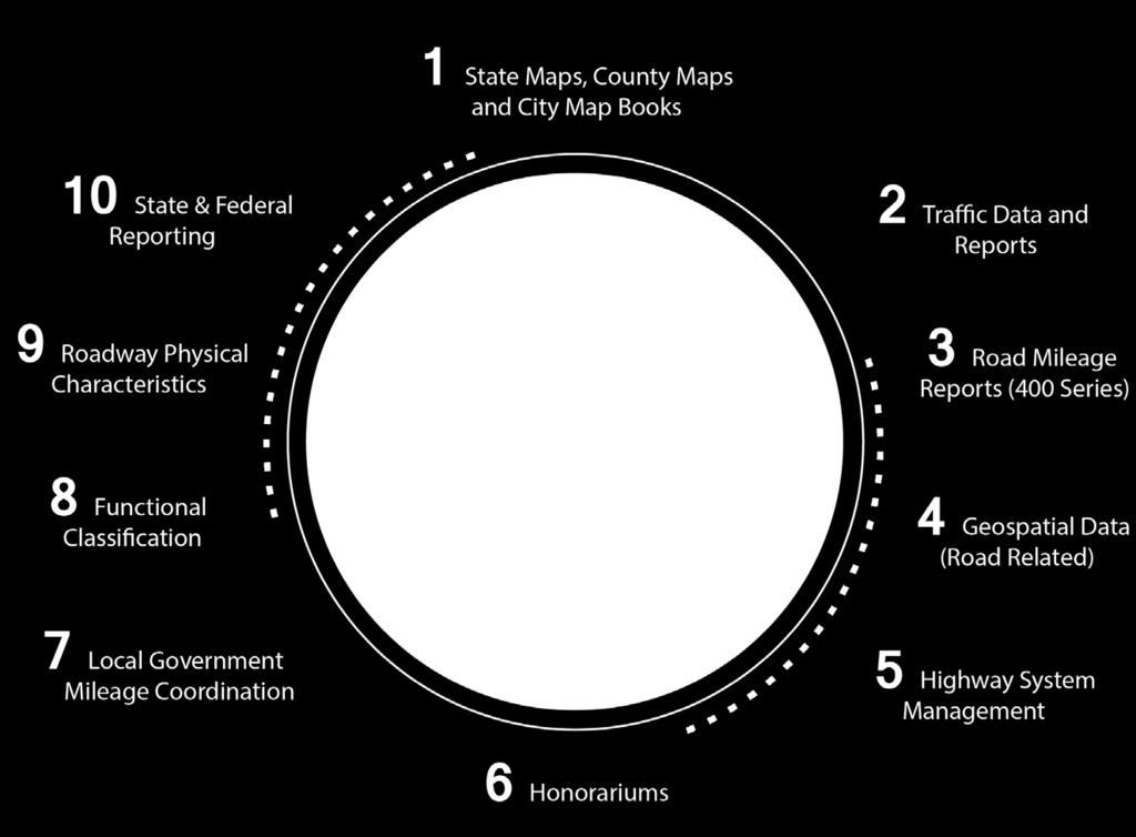
8 Top 10 OTD PRODUCTS


9 1 State Maps, County Maps, and City Map Books
10 1 State Maps, County Maps, and City Map Books

11 1 State Maps, County Maps, and City Map Books


12 2 Traffic Data and Reports Continuous Count Stations (CCS) OTD maintains approximately 275 continuous traffic counters, also known as Continuous Count Stations (CCS), statewide. CCS operate 24 hours a day, 7 days a week, 365 days a year. CCS collect vehicle classification, traffic volume, and traffic speed data.

13 2 Traffic Data and Reports Portable Tube Counts OTD also conducts short-term traffic counts, also called portable tube counts, at approximately 9,000 locations across the state every year. Portable tube counts typically collect traffic volume, and may collect vehicle classification data.
 data from approximately 35 portable sites and 14")

14 2 Traffic Data and Reports Weigh-In-Motion (WIM) OTD collects weigh-in-motion (WIM) data from approximately 35 portable sites and 14 permanent sites annually. WIM technology is utilized to collect axle and gross vehicle weight data in addition to vehicle counts, and vehicle classification.
15 2 Traffic Data and Reports Traffic counts are published through an online, interactive map application: Provides: AADTs, WIM, Truck Percentages, Historical AADTs, Hourly Volume and Vehicle Classification Data


16 Traffic Data Sources
17 3 Road Mileage Reports (400 Series)
18 4 Geospatial Data (Road Related) LRS (Linear Referencing System) Road Data Acquisition Program GIS Technology & Map Products Local Gov t Data Sharing Program
19 5 Highway Systems Management Administratively Manage Four Major Highway Systems State Highway System ~18,000 centerline miles Frequent small additions and subtractions Highway Functional Classification System National Highway System US Route Numbered System

20 6 Honorariums
21 7 Local Government Coordination Local Maintenance Improvement Grant (LMIG) Mileage MAP-21 Data Collection and Reporting Transportation Improvement Act (TIA) Mileage
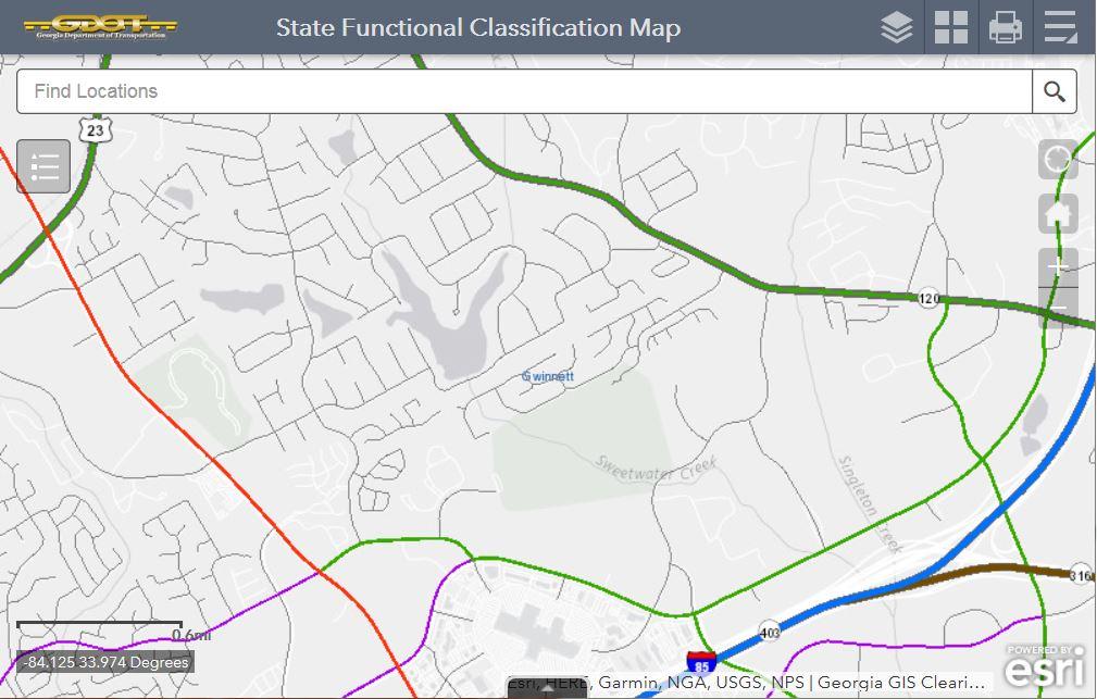
22 8 Functional Classification
23 9 Roadway Physical Characteristics OTD updates road centerline geometry and associated roadway characteristics for incorporation into GDOT databases. Road Data Collection Local Road Activity (LRA) notifications Various data mining procedures OTD maintains records for more than ~125,000 centerline miles of public roads in Georgia.
24 9 Roadway Physical Characteristics Attributes that are captured from various data sources and stored in a database Physical attributes: Payment type, number of lanes, shoulder width, etc. Geopolitical attributes: County and City boundaries Required for Federal Reporting Program Required for Intradepartmental uses
25 10 State & Federal Reporting 500 Series Financial Reports Certified Annual Public Mileage Report Centerline mileage data reports that supports: Local Maintenance and Improvement Grants (LMIG) program Transportation Investment Act (TIA) program
26 10 State & Federal Reporting Highway Performance Monitoring System (HPMS) Report Annual report due June 15 th A national level highway information system that includes data on the extent, condition, performance, use, and operating characteristics of the Nation's highways The major purpose of the HPMS is to support a data driven decision process within FHWA, the DOT, and the Congress
27 10 State & Federal Reporting Travel Monitoring Analysis System (TMAS) CCS data submitted monthly to the FHWA Vehicle Travel Information System (VTRIS) WIM data submitted annually to the FHWA
28 Quality Assurance and Customer Service High-Level of Quality Assurance Established rules and guidelines Refinements required over time (flexibility) Strive for Excellent Customer Service Data OTD collects (traffic, road data attributes, etc.) is provided to customers Migration to a public display of our data
29 Summary State & Federal Code Requirements Primary Business Groups Top 10 OTD Products Quality Assurance and Customer Service


30 Questions? Paul Tanner State Transportation Data Administrator Office of Transportation Data Georgia Department of Transportation
LOUISIANA DOTD TRAFFIC MONITORING/DATA COLLECTION PROGRAM & UPDATES
 LOUISIANA DOTD TRAFFIC MONITORING/DATA COLLECTION PROGRAM & UPDATES George Chike, P.E. Traffic Data Collection & Management System www.dotd.la.gov DOTD FIELD CREWS Routine traffic volume counts Vehicle
Tennessee Model Users Group. Organizational Meeting December 2, 2004
 Tennessee Model Users Group Organizational Meeting December 2, 2004 Introduction Steve Allen Transportation Manager 2 Traffic Planning & Statistics Office Planning Division TDOT Education Associate of
TDMS A Traffic Data Repository for Government and Business Use
 TDMS A Traffic Data Repository for Government and Business Use Prepared for: Arizona Association of County Engineers Prescott, Arizona February 13, 2014 Presented by: Mark Catchpole ADOT Multimodal Planning
Freight & Modal Data Program. MPOAC Freight Committee Quarterly Meeting January 26, 2017 Sunrise, Florida
 Freight & Modal Data Program MPOAC Freight Committee Quarterly Meeting January 26, 2017 Sunrise, Florida Overview Mission & Goals Freight Data Programs Recent and Upcoming Activities Mission & Goals FDOT
TRANSPORTATION RESEARCH BOARD. Spatial Modeling for Highway Performance Monitoring System Data: Part 2. Tuesday, March 6, :00-3:00 PM ET
 TRANSPORTATION RESEARCH BOARD Spatial Modeling for Highway Performance Monitoring System Data: Part 2 Tuesday, March 6, 2018 1:00-3:00 PM ET The Transportation Research Board has met the standards and
TRANSPORTATION RESEARCH BOARD. Spatial Modeling for Highway Performance Monitoring System Data: Part 1. Tuesday, February 27, :00-4:00 PM ET
 TRANSPORTATION RESEARCH BOARD Spatial Modeling for Highway Performance Monitoring System Data: Part 1 Tuesday, February 27, 2018 2:00-4:00 PM ET The Transportation Research Board has met the standards
KANSAS WORK ZONE SAFETY AND MOBILITY PROCESSES AND PROCEDURES
 KANSAS WORK ZONE SAFETY AND MOBILITY PROCESSES AND PROCEDURES Bureau of Transportation Safety and Technology 700 SW Harrison, Topeka, KS 66603 July 30, 2008 Definitions Significant Project All Federal-aid
RIDOT S Statewide Roadway and Asset Data Collection Project
 RIDOT S Statewide Roadway and Asset Data Collection Project ESRI User Conference 2017 Rafiq Basaria, DTS; Daniel Behnke DTS, Shane White, RIDOT Accent image here Primary Image here What is MIRE? Recommended
Presented by John Hudler Geospatial Group Leader Office of Transportation Data Georgia Department of Transportation
 Presented by John Hudler Geospatial Group Leader Office of Transportation Data Georgia Department of Transportation Collection, Quality Assurance and Reporting of the States roadway and transportation
Updating Virginia s Statewide Functional. Brad Shelton, VDOT Chris Detmer, VDOT Ben Mannell, VDOT
 Updating Virginia s Statewide Functional Classification System Brad Shelton, VDOT Chris Detmer, VDOT Ben Mannell, VDOT July 18, 2013 What is Functional Classification Use of Functional Classification Today
Traffic Data Programs at Virginia DOT: 10 plus Years of Innovation
 Traffic Data Programs at Virginia DOT: 10 plus Years of Innovation Presented by Digital Traffic Systems Inc. Mr. Peter Keen peter.keen@dtsits.com NATMEC 2012 Dallas, Texas 6/5/2012 Business Partner Perspective
Using GIS to Support Multi-year Pavement MR&R Need Analysis
 Using GIS to Support Multi-year Pavement MR&R Need Analysis Yichang(James) Tsai, Ph.D., P.E. Bo Gao, Ph.D. Candidate Georgia Institute of Technology Bryant Poole, P.E. JT Rabun, P.E. Georgia Department
STATEWIDE TRAFFIC ANALYSIS AND REPORTING SYSTEM (STARS II)
") STATEWIDE TRAFFIC ANALYSIS AND REPORTING SYSTEM (STARS II) June 3-5, 2014 Overview: Why is STARS II important? STARS II Statewide Traffic Analysis and Reporting System II Federal requirement for all State
STATEWIDE TRAFFIC ANALYSIS AND REPORTING SYSTEM (STARS II) June 3-5, 2014 Overview: Why is STARS II important? STARS II Statewide Traffic Analysis and Reporting System II Federal requirement for all State
REQUIREMENTS WEBINAR FEBRUARY 20, :00 2:30 P.M.
 ENHANCED NATIONAL HIGHWAY SYSTEM AND REQUIREMENTS WEBINAR FEBRUARY 20, 2013 1:00 2:30 P.M. Webinar Housekeeping Tips There is a designated time at the end of the presentation for questions and answers.
STATEWIDE TRAFFIC ANALYSIS AND REPORTING SYSTEM (STARS II)
") STATEWIDE TRAFFIC ANALYSIS AND REPORTING SYSTEM (STARS II) Transportation Planning and Programming Division (TPP) June 15th-17th, 2016 Planning Data & Analysis March 31, 2016 Overview: Why is STARS II
STATEWIDE TRAFFIC ANALYSIS AND REPORTING SYSTEM (STARS II) Transportation Planning and Programming Division (TPP) June 15th-17th, 2016 Planning Data & Analysis March 31, 2016 Overview: Why is STARS II
OPEN DATA & PROJECT TRACKER. Michael Chamberlain TPP, Data Management
 OPEN DATA & PROJECT TRACKER Michael Chamberlain TPP, Data Management October 11, 017 Table of contents 1 People 3 Attributes 4 3 Locations 5 4 Systems 6 5 Reports 7-8 6 Applications 8-13 7 Closing 14 Data
May 20, 2015 Russ Dudley VDOT - Local Assistance Division. May 20, 2015 Todd Halacy VDOT - Local Assistance Division
 NHS Performance Metrics: MAP-21 Transportation Performance Management Assessing Pavement and Bridge Condition for the National Highway Performance Program May 20, 2015 Russ Dudley VDOT - Local Assistance
Software Development Status and The New Hampshire Proposal Tom Roff April 12,2010
 Software Development Status and The New Hampshire Proposal Tom Roff April 12,2010 HPMS Development Status Field Manual is out on the street. Screen Design is complete Developers are staffed up and coding
GENERAL INTEREST ROADWAY DATA
 Approved: Effective: March 23, 2016 Office: Transportation Statistics Topic No.: 525-020-310-j Department of Transportation PURPOSE: GENERAL INTEREST ROADWAY DATA This procedure establishes Districts and
NATMEC June 30, 2014 Anita Vandervalk, PE, PMP
 NATMEC June 30, 2014 Anita Vandervalk, PE, PMP Agenda 1. Florida s MPM Program 2. Research Efforts and Progress 3. Source Book 4. Transitioning to Real Time Data 5. Next Steps Importance of Mobility Providing
RIDOT S Statewide Roadway and Asset Data Collection Project
 RIDOT S Statewide Roadway and Asset Data Collection Project GIS-T Conference 2017 Shane White Rhode Island DOT; Daniel Behnke DTS Accent image here Primary Image here RDIP Technical Assistance Started
One Maryland One Centerline. GIS-T 2014 May 7, 2014
 One Maryland One Centerline GIS-T 2014 May 7, 2014 Current Road Centerlines in Maryland SHA maintains a statewide centerline Supports HPMS program Represents state and local roads Capturing dual carriageways
New Jersey Department of Transportation. Local Freight Impact Fund Handbook. Procedures and Criteria for Local Freight Impact Fund Grant Program
 New Jersey Department of Transportation Local Freight Impact Fund Handbook Procedures and Criteria for Local Freight Impact Fund Grant Program Page 1 of 10 Overview The New Jersey Department of Transportation
MAP 21 Freight Provisions and Seaports
 MAP 21 Freight Provisions and Seaports September 20, 2012 American Association of Port Authorities 703.684.5700 www.aapa-ports.org 3 New Freight Eligibility in Core Highway Formula Programs Surface Transportation
Feasibility Study for a Statewide Road Centerline Data Set
 Feasibility Study for a Statewide Road Centerline Data Set Larry Spraker Fountains Spatial Schenectady, NY Andrew Rowan Douglas M Schleifer NJOIT-OGIS Statement of Problem In 2006, the NJ Geospatial Forum
Utilizing Transportation Data for Low Cost Safety Improvements
 Utilizing Transportation Data for Low Cost Safety Improvements Samuel Sturtz Transportation Planner Iowa Department of Transportation samuel.sturtz@dot.iowa.gov Photo Credits: Ken West- Kenneth G. West
IAn Imperative for, and Current
 ., IAn Imperative for, and Current Progress toward, National Traffic Monitoring Standards BY DAVID ALBRIGHT During the Middle Ages there was no single -. way of writing letters of the alphabet. Each state,
NYSDOT Roadway Inventory. Both On and Off the State System
 NYSDOT Roadway Inventory Both On and Off the State System 1 2 NYSDOT Highway Data Services Bureau Highway Data Traffic Monitoring Pavement Data Inventory of public roads, incl. LHI Systems designations
All Roads Do Not End at the State Line: Methodologies for Enabling Geodata Sharing Across Boundaries
 All Roads Do Not End at the State Line: Methodologies for Enabling Geodata Sharing Across Boundaries presented to 22 nd Geospatial Information Systems for Transportation Symposium presented by Julie Chizmas,
Traffic Data Quality Analysis. James Sturrock, PE, PTOE, FHWA Resource Center Operations Team
 Traffic Analysis James Sturrock, PE, PTOE, FHWA Resource Center Operations Team Source Material Traffic Measurement http://ntl.bts.gov/lib/jpodocs/repts_te/14058.htm Seven DEADLY Misconceptions about Information
NJDOT: Asset Management Strategies and Tools
 NEW JERSEY DEPARTMENT OF TRANSPORTATION NJDOT: Asset Management Strategies and Tools Wednesday, October 1, 2014 Afternoon Session (1:45pm 2:30pm) Presenters Michael Castaldo New Jersey Department Of Transportation
Design, Development, and Implementation of a Statewide Traffic Monitoring System
 TRANSPORTATION RESEARCH RECORD 1271 55 Design, Development, and Implementation of a Statewide Traffic Monitoring System DAVID PRESTON ALBRIGHT AND JOSEPH E. WILKINSON Statewide traffic monitoring standards
GDOT s Design-Build Program Past, Present and Future
 GDOT s Design-Build Program Past, Present and Future John D. Hancock, P.E. Assistant State Innovative Program Delivery Engineer September 16, 2013 Agenda Program Overview GA Code 32-2-81 (SB 70) Look Ahead
Freight Transportation Planning and Modeling Spring 2012
 Freight Model Validation Techniques Abstract Several reviews of validation techniques for statewide passenger and freight models have been published over the past several years. In this paper I synthesize
Metropolitan Planning Organization Safety Performance Measures Fact Sheet
 waco mpo Metropolitan Planning Organization Safety Performance Measures Fact Sheet Safety Performance Measures The Safety Performance Management Measures regulation supports the Highway Safety Improvement
METROPOLITAN PLANNING ORGANIZATION MEMORANDUM OF UNDERSTANDING FOR THE COASTAL REGION METROPOLITAN PLANNING ORGANIZATION BETWEEN
 METROPOLITAN PLANNING ORGANIZATION MEMORANDUM OF UNDERSTANDING FOR THE COASTAL REGION METROPOLITAN PLANNING ORGANIZATION BETWEEN The Counties of Chatham and Effingham, the municipalities of Bloomingdale,
Functional Classification Comprehensive Guide. Prepared by
 Functional Classification Comprehensive Guide Prepared by June 6, 2014 INTRODUCTION PURPOSE OF DOCUMENT The intent of this document is to provide a comprehensive guide to Virginia Department of Transportation
Building West Virginia DOT s Geospatial Capabilities:
 Building West Virginia DOT s Geospatial Capabilities: GIS Web Portal And Straight-line Diagram Application Current Status, Upcoming Enhancements, and Integration Marshall Burgess, WVDOT Don Kiel, GeoDecisions
EXISTING AND FUTURE FREIGHT GOODS MOVEMENT ASSESSMENT
 Technical Memorandum EXISTING AND FUTURE FREIGHT GOODS MOVEMENT ASSESSMENT Prepared by: April 2014 TABLE OF CONTENTS 1. Introduction... 3 1.1 Study Purpose... 3 1.2 Data Reference List... 3 2. Data sources...
Accelerated Sign Inventory and Management
 2015 The AASHTO Subcommittee on Maintenance (SCOM), Des Moines, Iowa Accelerated Sign Inventory and Management Erany Robinson-Perry Assistant State Maintenance Engineer Georgia Department of Transportation
Adaptation of HERS-ST Models for the South Carolina Interactive Interstate Management System
 Adaptation of HERS-ST Models for the South Carolina Interactive Interstate Management System presented to the Transportation Research Board HERS Modeling and Data Integration Conference presented by William
Technical Memorandum MULTIMODAL NEEDS. Prepared for: Oklahoma Department of Transportation. Prepared by:
 Technical Memorandum MULTIMODAL NEEDS Prepared for: Oklahoma Department of Transportation Prepared by: May 2015 Technical Memorandum The Technical Memos were written to document early research for the
Integrating MAP-21 Asset Management Data Using Esri s Roads and Highways. Imagine the result
 Integrating MAP-21 Asset Management Data Using Esri s Roads and Highways Imagine the result 1 17 2012 October ARCADIS 2014 Presenters David Ward Project Manger and Principal Architect for AzDOT Roads and
Alder Drive / Blair Road Bridge Replacement Projects
 Alder Drive / Blair Road Bridge Replacement Projects Presented By: County of El Dorado Community Development Agency Transportation Division Matthew Smeltzer, P.E. Deputy Director of Engineering Paul Hom,
POLICY FOR CONSTRUCTION OF NOISE BARRIERS IN RESIDENTIAL AREAS
 POLICY FOR CONSTRUCTION OF NOISE BARRIERS IN RESIDENTIAL AREAS I. Introduction Effective Date: October 31, 2006 The New Jersey Turnpike Authority (the Authority ) has reviewed and reexamined its current
Automated Permitting and Routing for OS/OW. GIS-T, 2010 Session Jay Adams - Oklahoma DOT
 Automated Permitting and Routing for OS/OW GIS-T, 2010 Session 4.3.1 Jay Adams - Oklahoma DOT Agenda Business Problem Project Background and Goals High-Level Needs Project Approach Expected Benefits Solution
Florida s Mobility Performance Measures and Experience
 Florida s Mobility Performance Measures and Experience By Douglas S. McLeod (corresponding author) Florida Department of Transportation 605 Suwannee Street Tallahassee, FL 32399-0450 Tel. 850-414-4932
FLORIDA DEPARTMENT OF TRANSPORTATION. District Six Intermodal Systems Development Office
 FLORIDA DEPARTMENT OF TRANSPORTATION District Six Intermodal Systems Development Office SCOPE OF SERVICES Transportation Statistics Support # 1 & 3 FM: Contract #: Major work type Transportation Statistics
GeoSpatial Enablement Strategy Appendix 6 Existing Business Systems and Workflows
 GeoSpatial Enablement Strategy Appendix 6 Existing Business Systems and Workflows February 18, 2005 Prepared for KDOT by Intergraph Mapping and GeoSpatial Solutions Table of Contents 1.1 Comprehensive
2 Purpose and Need. 2.1 Study Area. I-81 Corridor Improvement Study Tier 1 Draft Environmental Impact Statement
 2 Purpose and Need 2.1 Study Area Interstate 81 (I-81) is relied upon for local and regional travel and interstate travel in the eastern United States. It extends 855 miles from Tennessee to New York at
NATMEC June 22, 2010
 Traffic Monitoring Equipment Traffic Monitoring Equipment: Challenges, Lessons Learned, and its Role with the Commercial Traffic Enforcement Community NATMEC June 22, 2010 Lawrence Whiteside, Michigan
Jobs & Transportation Ramping it Up Roadway and Traffic Dan Groh, P.E.
 Jobs & Transportation Ramping it Up Roadway and Traffic Dan Groh, P.E. Ohio DOT Work Zone Process Review Ohio DOT Work Zone Process Review This review was conducted by the Ohio Department of Transportation
APPENDIX A: SHORT-TERM PROJECT DEPLOYMENTS
 APPENDIX A: SHORT-TERM PROJECT DEPLOYMENTS Page 1 of 15 ST-01: I-95 ITS DEPLOYMENT (DE STATE LINE TO AIRPORT) PROJECT DESCRIPTION AND SCOPE: Project will address gaps in ITS device coverage on I-95 from
SR 60 Grade Separation over CSX Railroad Traffic Technical Memorandum
 To: Marlon Bizerra, PE From: Thirulokesh Krishnan Email: thirulokesh.krishnan@atkinsglobal.com Phone: 210.321.2019 Date: Nov 25, 2014 Ref: cc: Kim Warren, Doug Reed, PE Subject: SR 60 Grade Separation
Central Data Repository for Traffic Data Collection in Rural Areas and Corridors Supporting Freight Mobility
 Central Data Repository for Traffic Data Collection in Rural Areas and Corridors Supporting Freight Mobility Tuesday, October 23, 2018 Michael Wieck International Road Dynamics Starting Point Technology
National Performance Research Data Set (NPMRDS): Travel Time Probe Data. Northwestern Indiana Regional Planning Commission
: Travel Time Probe Data. Northwestern Indiana Regional Planning Commission") National Performance Research Data Set (NPMRDS): Travel Time Probe Data Northwestern Indiana Regional Planning Commission Topics Presentation Will Cover: What is the NPMRDS? How is the NPMRDS used? What
National Performance Research Data Set (NPMRDS): Travel Time Probe Data Northwestern Indiana Regional Planning Commission Topics Presentation Will Cover: What is the NPMRDS? How is the NPMRDS used? What
ACTION TRANSMITTAL
 ACTION TRANSMITTAL 2016-07 DATE: December 4, 2015 TO: FROM: TAC Planning MTS Staff PREPARED BY: Rachel Wiken (651) 602-1572 SUBJECT: REQUESTED ACTION: RECOMMENDED MOTION: Functional Class Change #1330
Traffic and ESAL Summary for the MnROAD Mainline. (July 1994 June 2011)
") Traffic and ESAL Summary for the MnROAD Mainline (July 1994 June 2011) Eric Peterson, EIT Graduate Engineer Minnesota Department of Transportation August 22, 2011 Executive Summary Since its construction
Traffic and ESAL Summary for the MnROAD Mainline (July 1994 June 2011) Eric Peterson, EIT Graduate Engineer Minnesota Department of Transportation August 22, 2011 Executive Summary Since its construction
SBCAG STAFF REPORT. MAP-21/FAST Act Performance Measures and Targets. MEETING DATE: September 20, 2018 AGENDA ITEM: 4H
 SBCAG STAFF REPORT SUBJECT: MAP-21/FAST Act Performance Measures and Targets MEETING DATE: September 20, 2018 AGENDA ITEM: 4H STAFF CONTACT: Andrew Orfila, Jared Carvalho RECOMMENDATION: Approve and accept
NC General Statutes - Chapter 136 Article 3A 1
 Article 3A. Transportation Systems in and around Municipalities. 136-66.1. Responsibility for streets inside municipalities. Responsibility for streets and highways inside the corporate limits of municipalities
SERPM8.0 TRAVEL DEMAND MODEL UPDATE DATA AVAILABILITY AND NEEDS
 SERPM8.0 TRAVEL DEMAND MODEL UPDATE DATA AVAILABILITY AND NEEDS UPDATED JANUARY 18 2017 UPDATES IN RED DATA ITEM DESCRIPTION/COMMENTS AGENCY/DETAILS/TIMING DATA STATUS A1 A2 Geographies for development
VaaaN. Corporate Overview. VaaaN Infra 2016, All Rights Reserved
 VaaaN Corporate Overview VaaaN Infra 2016, All Rights Reserved CONTENTS Highway ITS Toll Systems Electronic Toll Collection (ETC) Weigh In Motion (WIM) Advanced Traffic Management System (ATMS) Smart City
Florida Department of Transportation 605 Suwannee Street Tallahassee, FL
 RICK SCOTT GOVERNOR Florida Department of Transportation 605 Suwannee Street Tallahassee, FL 32399-0450 MIKE DEW SECRETARY REQUEST FOR INFORMATION (RFI) from the Florida Department of Transportation INTRODUCTION
Appendix D Functional Classification Criteria and Characteristics, and MnDOT Access Guidance
 Appendix D Functional Classification Criteria and Characteristics, and MnDOT Access Guidance Functional classification identifies the role a highway or street plays in the transportation system. Some highways
FDOT State Safety Office History, Accomplishments & Planned FHWA Funded Efforts. Presenters: Kathryn Waters & Joseph Santos July 29, 2015
 FDOT State Safety Office History, Accomplishments & Planned FHWA Funded Efforts Presenters: Kathryn Waters & Joseph Santos July 29, 2015 Welcome & Introductions Name Organization Your Role & Responsibility
MINNESOTA. Jurisdictional Realignment Project Final Report
 MINNESOTA Jurisdictional Realignment Project Final Report November 2012 Table of Contents Executive Summary... 1 Objective... 1 Approach... 1 Prior studies... 2 Phase 1 Assigning the right roads to the
MARC Congestion Management Process Policy
 MARC Congestion Management Process Policy Adopted by the MARC Board of Directors on May 24, 2011 Background Traffic congestion can be generally defined as a condition where the volume of users on a transportation
Esri Roads and Highways An Introduction. Nathan Easley Rahul Rakshit
 Esri Roads and Highways An Introduction Nathan Easley Rahul Rakshit Roads and Highways Linear Referencing for the Transportation Enterprise GIS-enabled LRS platform LRS management LRS editing & maintenance
Functional Classification
 Functional Classification HB 3202 (2007) Report to Governor and General Assembly Virginia Department of Transportation 1401 East Broad Street Richmond, Virginia 23219 January 2009 A PLAN FOR REASSIGNING
The Highway Economic Requirements System (HERS): How HERS Works
: How HERS Works") The Highway Economic Requirements System (HERS): How HERS Works presented to Committee for a Study of the Future Interstate Highway System presented by Rich Margiotta, Ph.D. December 20, 2016 What We ll
The Highway Economic Requirements System (HERS): How HERS Works presented to Committee for a Study of the Future Interstate Highway System presented by Rich Margiotta, Ph.D. December 20, 2016 What We ll
Creating Master Data Sets Build it once, use it a bunch
 Creating Master Data Sets Build it once, use it a bunch David Blackstone Office of Technical Services Dan Casey Chief Business Development Officer What When Why How Who What When Master Data Set Why How
UCI ITS Research Team
 UCI ITS Research Team Principal Investigator: Professor Stephen G. Ritchie Asst. Project Scientist: Dr. Andre Tok Graduate Student Researcher: Fatemeh Ranaiefar Graduate Student Researcher: Kyungsoo Jeong
APPENDIX D. Glossary D-1
 APPENDIX D Glossary D-1 Glossary of Transportation Planning Terms ANNUAL AVERAGE DAILY TRAFFIC (AADT): The total number of vehicles passing a given location on a roadway over the course of one year, divided
Performance Based Practical Design. An FHWA Perspective
 Performance Based Practical Design An FHWA Perspective Early Adopters Research on PBPD and Background Materials http://www.fhwa.dot.gov/design/pbpd/ FAST Act Changes that Encourage PBPD On the NHS, design
Project Title: Using Truck GPS Data for Freight Performance Analysis in the Twin Cities Metro Area Prepared by: Chen-Fu Liao (PI) Task Due: 12/31/2013
 Task Due: 12/31/2013") Project Title: Using Truck GPS Data for Freight Performance Analysis in the Twin Cities Metro Area Prepared by: Chen-Fu Liao (PI) Task Due: 12/31/2013 TASK #5: IDENTIFY FREIGHT NODE, FREIGHT SIGNIFICANT
Project Title: Using Truck GPS Data for Freight Performance Analysis in the Twin Cities Metro Area Prepared by: Chen-Fu Liao (PI) Task Due: 12/31/2013 TASK #5: IDENTIFY FREIGHT NODE, FREIGHT SIGNIFICANT
GIS USE IN PAVEMENT MARKING AND SIGN MANAGEMENT: AN INTEGRATED APPROACH
 GIS USE IN PAVEMENT MARKING AND SIGN MANAGEMENT: AN INTEGRATED APPROACH Omar Smadi 1, Zachary Hans 2, and Neal Hawkins 3 ABSTRACT Geographic information system (GIS) technology is a key component of all
Shoulder Widening Prioritization Discussion
 Shoulder Widening Prioritization Discussion Lindsey Bruer Planning Director March 2, 2018 District 8 ATP Meeting mndot.gov District 4 Shoulder Widening Study Evaluation Criteria: 3/8/2018 2 Evaluation
HIGH RISK RURAL ROADS (HRRR)
") APPENDIX #1 HIGH RISK RURAL ROADS (HRRR) 6. High Risk Rural Roads The Puerto Rico Highway and Transportation Authority (PRHTA) evaluated the need to identify high risk rural roads within the State highway
APPENDIX #1 HIGH RISK RURAL ROADS (HRRR) 6. High Risk Rural Roads The Puerto Rico Highway and Transportation Authority (PRHTA) evaluated the need to identify high risk rural roads within the State highway
RESOLUTION NO
 RESOLUTION NO. 2018-12 RESOLUTION OF THE SOUTHEASTERN WISCONSIN REGIONAL PLANNING COMMISSION AMENDING THE TRANSPORTATION IMPROVEMENT PROGRAM FOR SOUTHEASTERN WISCONSIN: 2017-2020 WHEREAS, the Southeastern
Project Update. Roads and Highways Implementation. Emiko Hori. West Virginia Department of Transportation
 Roads and Highways Implementation at WVDOT Project Update Emiko Hori Geospatial Transportation Information (GTI) Section Geographic Information System (GIS) Unit Agenda 1. Development History 2. Roads
Wall Asset Management Implementation at Colorado Department of Transportation. Bryant Walters, Collins Engineers Mark Vessely, Shannon & Wilson
 Wall Asset Management Implementation at Colorado Department of Transportation Bryant Walters, Collins Engineers Mark Vessely, Shannon & Wilson Colorado DOT Wall Asset Management Program Development Coding
Appendix D: Functional Classification Criteria and Characteristics, and MnDOT Access Guidance
 APPENDICES Appendix D: Functional Classification Criteria and Characteristics, and MnDOT Access Guidance D.1 Functional classification identifies the role a highway or street plays in the transportation
Safety Management System for Israel
 Safety Management System for Israel Dr. Simon Lewis and Joe Garvey AgileAssets, Inc. Traffic Records Forum New Orleans July 27, 2010 A nation under pressure * Do things well /smart * Do things right first
Transportation Committee
 Transportation Committee For the Metropolitan Council meeting of April 9, 2008 ADVISORY INFORMATION Date Prepared: March 27, 2008 Subject: Lowry Avenue Intermodal Freight Connector Committee Report Item:
The ipems MAP-21 Module
 The ipems MAP-21 Module Producing the information you need from the National Performance Management Research Data Set (NPMRDS) January 2015 Innovation for better mobility Use the ipems MAP-21 Module to
Iowa s Deficient Bridges
 Iowa s Deficient Bridges Strategies to improve and maintain the condition of Iowa s bridges February 2008 The Road Information Program 1726 M Street, NW, Suite 401 Washington, DC 20036 Phone: (202) 466-6706
Esri Roads and Highways An Introduction
 Esri International User Conference San Diego, California Technical Workshops July 24, 2012 Esri Roads and Highways An Introduction William Isley Majunu Seran Agenda Product Overview Desktop - Demo: Network
Chapter 2 Transportation Element Goals, Objectives and Policies
 Chapter 2 Transportation Element Goals, Objectives and Policies City of Belleview Comprehensive Plan Adopted by Ord 2016-10 on July 5, 2016 GOALS, OBJECTIVES AND POLICIES Goal 2 Transportation...1 Objective
Subject: Late Season/Cold Weather Temporary Pavement Markings
 Minnesota Department of Transportation MEMORANDUM Office of Traffic, Safety and Operations Office Telephone: 651-234-7377 Mail Stop 725 Fax: 651-234-7370 1500 West County Road B-2 Roseville, MN 55113 Date:
Roadway Intersection Inventory and Remote Sensing
 Veneziano 1 Roadway Intersection Inventory and Remote Sensing David Veneziano Center for Transportation Research and Education Iowa State University ABSTRACT The application of remote sensing to the collection
Metropolitan Planning Organization Safety Performance Measures Fact Sheet
 Metropolitan Planning Organization Safety Fact Sheet Safety The Safety Performance Management Measures regulation supports the Highway Safety Improvement Program (HSIP) and requires State Departments of
Urban Arterial Roads Pavement Data Collection. October 23, 2012 Todd M. Halacy, P.E. VDOT Local Assistance Division
 Urban Arterial Roads Pavement Data Collection October 23, 2012 Todd M. Halacy, P.E. VDOT Local Assistance Division Presentation Topics Background Information: CTB Subcommittee & Local Government Workgroup
Business Item Transportation Committee Item
 Business Item Transportation Committee Item 2008-88 Meeting date: March 24, 2008 Council meeting: April 9, 2008 ADVISORY INFORMATION Date: March 19, 2008 Subject: Lowry Avenue Intermodal Freight Connector
Updating Virginia s Statewide Functional Classification System. Briefing to MPOs, PDCs, and Local Governments
 Updating Virginia s Statewide Functional Classification System Briefing to MPOs, PDCs, and Local Governments October 15 & 19, 2012 Functional Class 101 Shelton s FC Game Research Phase Today s Review New
Automated Statewide Highway Intersection Safety Data Collection and Evaluation Strategy
 Automated Statewide Highway Intersection Safety Data Collection and Evaluation Strategy Fan Yang, Ph.D. Candidate Department of Civil and Environmental Engineering, University of Wisconsin-Madison, Madison,
FHWA TPM Framework and Capability Maturity Model (CMM)
") TPM Workshop FHWA TPM Framework and Capability Maturity Model (CMM) Philadelphia, PA November 29 & 30, 2017 Why TPM? 2 Rulemakings TPM-Related Rules Rule Effective Date Regulatory Chapter Safety Performance
TPM Workshop FHWA TPM Framework and Capability Maturity Model (CMM) Philadelphia, PA November 29 & 30, 2017 Why TPM? 2 Rulemakings TPM-Related Rules Rule Effective Date Regulatory Chapter Safety Performance
CHAPTER 5. City of Greensburg Comprehensive Plan. Introduction. Transportation Goals & Objectives
 CHAPTER 5 TRANSPORTATION Introduction The transportation system forms the backbone of the community. I-74 provides the community with connections to larger metropolitan areas such as Indianapolis and Cincinnati.
Continuing Services Contract for Statistics Traffic Data Collection and Analysis. FM No.:
 Continuing Services Contract for Statistics Traffic Data Collection and Analysis I. Purpose FM No.: 430257-3-12-01 The main objectives of this contract are to provide professional and technical services
100 Design Controls and Exceptions
 100 Design Controls and Exceptions Table of Contents 100 Introduction... 1 101 Functional Classification... 1 101.1 General... 1 101.2 Urban & Rural... 1 101.3 Classification Used In ODOT Design Criteria...
Addendum #3 to the Regional Transportation Plan
 Nashville Area Metropolitan Planning Organization Addendum #3 to the Regional Transportation Plan Effective November 21, 2018 Nashville Area Metropolitan Planning Organization 138 Second Avenue North Nashville,