Monitoring Irrigation Projects
|
|
|
- Anastasia Long
- 6 years ago
- Views:
Transcription
1
2 Monitoring Irrigation Projects Process of collecting information about Irrigation projects analyzing these in relation to execution, so that deviations are minimal IP created in a project by identifying & mapping of irrigation canal networks Tagging status of completion of the entire conveyance & distribution system, irrigation & drainage structures
3 Set performance standards Objectives Ensure implementation of construction program Compare actual physical & financial achievements with set targets Identify deviations, shortfalls, lagging areas & their effect on overall implementation program and inter-related activities and analyze their causes Suggest corrective measures for overcoming bottlenecks Review the project, suggest modifications in implementation procedures, program and targets Compile the information on financial & physical status
4 Stages of monitoring 1. Preliminary preparations 2. Field visit 3. Collection of information & review of status of project 4. Wrap up meeting with Project Authorities 5. Preparation of status Report 6. Follow up of action points
5 Irrigation Potential Ultimate potential, potential created up to last year program for current year & achievement. Reasons for lag in potential Status of utilization vrs creation Statement of distributary-wise Ultimate Potential & Potential Created
6 STATUS REPORT PARA PART - I Executive Summary Para 1 Project in brief (Location, components, benefits, estimated cost, year of approval, inter-state aspects, year of start, targetted date of completion, external source of funding,) Para 2 Organizational and Management aspects (Adequacy of org set-up & physical & financial program) Para 3 PHYSICAL PROGRESS (our concern) (% completion of various components & achievement of potential.) Para 4 Financial progress (Latest expenditure details, outlays for the current plan/year.) Para 5 Critical issues in focus (critical issues needing immediate attention of Govt/Project Authorities.) PART II Project components as being executed Changes in the scope
7 APPROACH OF MONITORING THROUGH GIS AND RS Mapping of existing irrigation infrastructure in project Comparing with proposed irrigation infrastructure, Assessing IP created in project command.
8 APPROACH OF MONITORING THROUGH GIS AND RS Study of toposheet Path/row determination utility software of NRSC Masking study area- vector polygon Acquisition of High resolution CARTOSAT digital satellite data Field database on irrigation infrastructure and Irrigation Potential Mosaicking of CARTOSAT satellite data
9 Steps in Monitoring in GIS 1. Field data collection- Maps, T chart of canal network, CCA-IP proposed, IP created as on specified date 2. CARTOSAT data acquisition 3. Field database creation on IP and Irrigation infrastructureaqueducts, super passages, syphons, H.P. drains, road/cart/foot bridges 4. CARTOSAT database creation- mosaic and subset 5. Geo- database creation- Creation of all vector layers along with attributes 6. Mapping of Irrigation infrastructure and base layers 7. Assessment of Irrig infrastructure & IP- Comparison of proposed & satellite derived IP based on hydraulic connectivity 8. Ground truth verification 9. Preparation of report encompassing synopsis of analysis
10 Different scenarios Canal completed- canal length = field design, If length do not match exactly, - 98% for long canals or 97% for short canals Canal short in length Gaps in middle reaches- Whenever gaps exist in different stretches of the canal. length of canal continuous from off-take is only considered for IP assessment. Gaps due to pending structures - discontinuous due to pending structures, canal incomplete. Length of canal continuous from offtake considered for IP. No off-take connectivity- Whenever a canal is not connected to its parent canal even the canal is constructed this is taken as incomplete. Canal pending- If a canal is not identified in the satellite image as per field design, it is incomplete.
11 IRRIGATION POTENTIAL CREATED- Inputs reqd Proposed length of canal Satellite derived lengths; physical progress of canal construction for corresponding canal IP proposed under each canal Gaps existing in different stretches of canal network, No of gaps & lengths, their chainage derived hydraulically connected length of a particular canal. No of DPOs (Direct Pipe Outlet), their contribution to the IP as per field data; chainages to assess Hyd. Connnectivity.
12 Estimation of IP under various canals IP of minors & DPOs hydraulically connected & completed are summed up to arrive at total IP created under the distributary. IP of Distributaries & DPOs hyd connected & completed are summed up - IP created under Branch canal. All the IP of Branch Canals & DPOs hyd connected and completed are summed up to IP created under Main Canal. IP of Main Canals and DPOs hyd connected & completed are summed up to total IP created under Project
13 Please Note Balance IP = proposed IP - IP created under each canal All the IP values of minors and DPOs which are hydraulically connected and completed are summed up to arrive at the total IP created under the minor. If there are no DPOs, the IP created is estimated proportionally based on the hydraulically connected length of canal
14 Example - 1 Proposed IP = 250 ha Proposed length : 3 km Satellite derived : 2.5 km (canal is not connected to main) Satellite derived IP= 250 ha* 0/3.0 =0 ha Status: Incomplete Not connected to Distributary
15 Example- 2 Proposed IP = 150 ha Proposed length : 2 km Satellite derived : 1.5 km (canal complete up to 1 km, & hydraulically connected) Satellite derived IP= 150 ha* 1.0/2.0 = 75 ha Status: Incomplete DPO 2 (25 ha)

16

17
18

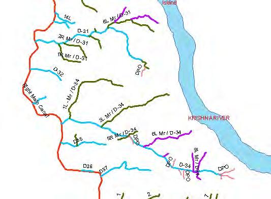
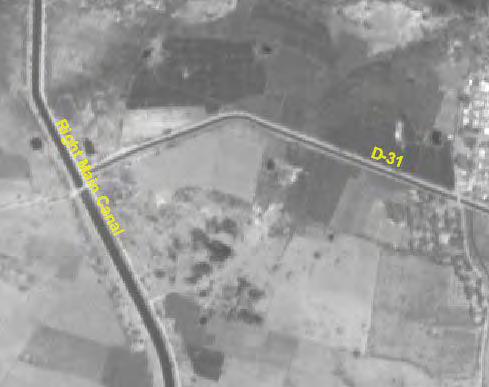
19 Right Main Canal

20 RMC system with canal ID
21

22


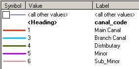
23 Minor 8R Minor / Dy.31

24 Left main canal JURALA Reservoir Krishna river Right main canal

25 JURALA Dam

26 Right main canal

27
28
29 Distributary
30 LET US DO IT PRACTICALLY
Water Conveyance System
 Water Conveyance System Water Conveyance System Water Conveyance System Canals Conduits Canals-Canals are the structure constructed to carry or transport water from the reservoir to the area which is to
Assessment of Irrigation Potential Utilization in Major Irrigation Project Using Geospatial Data
 Assessment of Irrigation Potential Utilization in Major Irrigation Project Using Geospatial Data Muthyam Shanker Abstract Many irrigation projects were constructed in India post-independence period spending
R.T.Thokal Head, Dept. of Irrigation and Drainage Engineering College of Agril Engg. And Tech., Dr.BSKKV, Dapoli Maharashtra State, INDIA
 Application of GIS-based SWAT framework for water management of irrigation project under rotational water supply S.D. Gorantiwar Head, Dept. of Irrigation and Drainage Engineering Dr. A. S. College of
Irrigation Structures 2. Dr. M. R. Kabir
 CHAPTER 9 Irrigation Structures 2 Dr. M. R. Kabir Professor and Head, Department of Civil Engineering University of Asia Pacific (UAP), Dhaka LECTURE 22 What is Cross Drainage Works? In an irrigation project,
GIS Automation in Ground Water Analysis
 International Journal of Research in Engineering and Science (IJRES) ISSN (Online): 2320-9364, ISSN (Print): 2320-9356 Volume 5 Issue 5 ǁ May. 2017 ǁ PP. 25-29 GIS Automation in Ground Water Analysis S.
Distributed Hydrological Model For An Ungauged Subcatchment
 Distributed Hydrological Model For An Ungauged Subcatchment Dr. Krishna Mohan M Professor of Civil Engineering, Malla Reddy Engg College (Autonomous under JNTUH), Secunderabad Abstract Rainfall and runoff
Irrigation Design (1) IHD302
 IHD302") Irrigation Design (1) IHD302 Instructors : 1-Prof Dr. Kamal Abou Alhasan 2- Dr. Ashraf Saad 3- Dr. Soha Elayoty 4- Dr. Mohamed Attia 5- Dr. Hany Gomaa Topics Design of irrigation system Design of Bridge
Irrigation Design (1) IHD302 Instructors : 1-Prof Dr. Kamal Abou Alhasan 2- Dr. Ashraf Saad 3- Dr. Soha Elayoty 4- Dr. Mohamed Attia 5- Dr. Hany Gomaa Topics Design of irrigation system Design of Bridge
FOREST COVER MAPPING AND GROWING STOCK ESTIMATION OF INDIA S FORESTS
 FOREST COVER MAPPING AND GROWING STOCK ESTIMATION OF INDIA S FORESTS GOFC-GOLD Workshop On Reducing Emissions from Deforestations 17-19 April 2007 in Santa Cruz, Bolivia Devendra PANDEY Forest Survey of
Types of cross drainage works
 Definition: A cross drainage work is a structure carrying the discharge from a natural stream across a canal intercepting the stream. Canal comes across obstructions like rivers, natural drains and other
MODERNIZATION OF IRRIGATION SCHEMES THROUGH TRAINING OF WATER USER ASSOCIATIONS IN THE RAPID INTERVENTION PROGRAM
 MODERNIZATION OF IRRIGATION SCHEMES THROUGH TRAINING OF WATER USER ASSOCIATIONS IN THE RAPID INTERVENTION PROGRAM Guy Fipps 1 and Gabriele Bonaiti 2 ABSTRACT The Rapid Intervention Program (RIP) is unique
Module 3. Irrigation Engineering Principles. Version 2 CE IIT, Kharagpur
 Module 3 Irrigation Engineering Principles Lesson 8 Conveyance Structures for Canal Flows Instructional objectives On completion of this lesson, the student shall learn the following: 1. The need for structures
Fig: Alignment of a ridge or watershed canal (Head reach of a main canal in plains)
") SYSTEM OF IRRIGATION CANAL CHAPTER 6 Alluvial Soil and Non-Alluvial Soil The soil which is formed by transportation and deposition of silt through the agency of water, over a course of time, is called
SYSTEM OF IRRIGATION CANAL CHAPTER 6 Alluvial Soil and Non-Alluvial Soil The soil which is formed by transportation and deposition of silt through the agency of water, over a course of time, is called
HYDRAULIC DESIGN OF PIPE DISTRIBUTION NETWORK FOR IRRIGATION PROJECT
 International Journal of Civil Engineering and Technology (IJCIET) Volume 9, Issue 7, July 2018, pp. 1109 1116, Article ID: IJCIET_09_07_116 Available online at http://www.iaeme.com/ijciet/issues.asp?jtype=ijciet&vtype=9&itype=7
Command Area Management Study of Karjan Dam Gujarat, India using Remote Sensing and GIS
 IJSTE - International Journal of Science Technology & Engineering Volume 1 Issue 11 May 2015 ISSN (online): 2349-784X Command Area Management Study of Karjan Dam Gujarat, India using Remote Sensing and
GOVERNMENT OF INDIA MINISTRY OF WATER RESOURCES GUIDELINES COMMAND AREA DEVELOPMENT & WATER MANAGEMENT PROGRAMME NEWDELHI JULY,2010
 GOVERNMENT OF INDIA MINISTRY OF WATER RESOURCES GUIDELINES ON COMMAND AREA DEVELOPMENT & WATER MANAGEMENT PROGRAMME NEWDELHI JULY,2010 Introduction 1.1 The Command Area Development & Water Management (CADWM)
Executive Summary of Bistan Lift IrrigationProject
 Executive Summary of Bistan Lift IrrigationProject INTRODUCTION:- 1.1 (i) AIM(S) OF THE PROJECT WORK : The main objective of Bistan Lift Irrigation Scheme is to provide irrigation facilities to the water-scare
CATCHMENT AREA TREATMENT PLAN
 CATCHMENT AREA TREATMENT PLAN 1 NEED FOR CATCHMENT AREA TREATMENT It is a wellestablished fact that reservoirs formed by dams on rivers are subjected to sedimentation. The process of sedimentation embodies
Zeshan Yasin 1, Ghulam Nabi 2
 International Journal of Scientific & Engineering Research, Volume 5, Issue 12, December-2014 154 Alternative Management Plan for Flash Floods/ Flows of Mithawan Hill Torrents in Pakistan Zeshan Yasin
Proposed Solution for Implementation, Monitoring and Maintaining Vehicle Tracking System for vehicles of Solid Waste Management
 Proposed Solution for Implementation, Monitoring and Maintaining Vehicle Tracking System for vehicles of Solid Waste Management Table of Contents Solution Architecture 7 Key Challenges and Approach for
STATEMENT OF QUALIFICATIONS. Pre-qualification Submissions for. Prime Engineering Consultant Services on. Water Management Projects
 STATEMENT OF QUALIFICATIONS Pre-qualification Submissions for Prime Engineering Consultant Services on Water Management Projects INTRODUCTION Alberta Transportation is accepting submissions from Consulting
Irrigation Crossing Structures
 Irrigation Crossing Structures Road Open channel H.R. Open Irrigation Canal Tail escape Water way + Road way Culvert Bridge Water way + Water way Syphon Aqueduct Retaining walls Lining ١ 1- FUNCTION AND
Irrigated Lands Mapping and Permit GIS Data
 TECHNICAL MEMORANDUM SUBJECT: PREPARED BY: Irrigated Lands Mapping and Permit GIS Data Robert E. King Sunrise Engineering, Inc. DATE: January 11, 2003 Introduction Irrigated agriculture represents the
Tangible benefits of technological prospection and prefeasibility studies in SHP projects Ing. Sergio Armando Trelles Jasso
 5 th and 6 th December 2012, Panama City, Panama Tangible benefits of technological prospection and prefeasibility studies in SHP projects Ing. Sergio Armando Trelles Jasso Agenda Artisanal vs Technological
STATEMENT OF QUALIFICATIONS. Pre-qualification Submissions for. Prime Engineering Consultant Services on. Water Management Projects
 STATEMENT OF QUALIFICATIONS Pre-qualification Submissions for Prime Engineering Consultant Services on Water Management Projects INTRODUCTION Alberta Transportation is accepting submissions from Consulting
APPENDIX F: CALTRANS COST ESTIMATE TEMPLATE (included in Appendix AA of the CALTRANS Project Development Procedures Manual)
") APPENDIX F: CALTRANS COST ESTIMATE TEMPLATE (included in Appendix AA of the CALTRANS Project Development Procedures Manual) PROJECT DESCRIPTION: (Enter Type of Project Planning Cost Estimate as Title)
APPENDIX F: CALTRANS COST ESTIMATE TEMPLATE (included in Appendix AA of the CALTRANS Project Development Procedures Manual) PROJECT DESCRIPTION: (Enter Type of Project Planning Cost Estimate as Title)
DEVELOPMENT OF HYDROGRAPHIC DATASET FOR TURKEY: INITIAL STUDIES
 DVLOPMNT OF HYDROGRPHIC DTST FOR TURKY: INITIL STUDIS Serkan Girgin 1, Zuhal kyürek 2, Nurünnisa Usul 3 1 Middle ast Technical University, Department of nvironmental ngineering İnönü Bulvarı, 06531, nkara-turkey,
Implementation Status & Results India Uttar Pradesh Water Sector Restructuring Project (P050647)
") Public Disclosure Authorized Public Disclosure Authorized The World Bank Implementation Status & Results India Uttar Pradesh Water Sector Restructuring Project (P050647) Operation Name: Uttar Pradesh Water
Public Disclosure Authorized Public Disclosure Authorized The World Bank Implementation Status & Results India Uttar Pradesh Water Sector Restructuring Project (P050647) Operation Name: Uttar Pradesh Water
Pro-Poor Interventions in Irrigated Agriculture in Andhra Pradesh
 Pro-Poor Interventions in Irrigated Agriculture in Andhra Pradesh C. Sithapathi Rao * IRRIGATION IN ANDHRA PRADESH Andhra Pradesh (AP) is the fifth largest State in India with a geographical area of 2.75
USACE LEVEE AND DAM SAFETY PROGRAM AND ISSUES
 USACE LEVEE AND DAM SAFETY PROGRAM AND ISSUES 237 237 237 217 217 217 200 200 200 80 119 27 252 174.59 1 255 255 255 0 0 0 163 163 163 131 132 122 239 65 53 110 135 120 112 92 56 62 102 130 102 56 48 130
2-4 April 2019 Taets Art and Event Park, Amsterdam CLICK TO KNOW MORE
 Co-Host Host 2-4 April 2019 Taets Art and Event Park, Amsterdam CLICK TO KNOW MORE Government of Andhra Pradesh Groundwater and Water Audit Department MINISTRY OF WATER RESOURCES Real Time Water Resources
Alberta Rainfall Runoff Response
 Alberta Rainfall Runoff Response Introduction The runoff response to a rainfall event is a function of many complex hydrologic processes. Some of the major factors in the rainfall-runoff process are basin
DPR GUIDELINES FOR ERM OF IRRIGATION PROJECTS
 DPR GUIDELINES FOR ERM OF IRRIGATION PROJECTS 1.0 INTRODUCTION RAJEEV SINGHAL Director NWA, CWC, Pune Modernisation of Irrigation Project includes extension, renovation & modernisation components of existing
Statistical indices for the performance evaluation of Ukai right bank canal, Gujarat.
 Scientific Journal of Impact Factor (SJIF): 4.72 International Journal of Advance Engineering and Research Development Volume 4, Issue 1, January -2017 e-issn (O): 2348-4470 p-issn (P): 2348-6406 Statistical
Application of Remote Sensing in studying forest cover conditions of protected areas in Himachal Pradesh, India
 Application of Remote Sensing in studying forest cover conditions of protected areas in Himachal Pradesh, India Vandana Kumari Chauhan*, Ruchika Acharya, Amit Kumar and R.D. Singh, Council of Scientific
GUIDELINES FOR PREPARATION OF MINE CLOSURE PLAN
 Preamble : GUIDELINES FOR PREPARATION OF MINE CLOSURE PLAN 1. The Central Government vide Notification No. GSR 329 (E) dated 10.04.2003 and No. GSR 330 (E) dated 10.04.2003 amended the Mineral Concession
Maintenance Program Guideline for Owners of Ammonia Plants
 Maintenance Program Guideline for Owners of Ammonia Plants Contents Maintenance Program Guideline for Owners of Ammonia Plants... 0 a) Title Page, owner/operator, the plant location.... 4 b) Contents Page...
Use of Space-based Systems for Water Resources Management In India
 49 th Session of UN-COPUOS (7-16 June 2006) Agenda Item 12: Space and Water Use of Space-based Systems for Water Resources Management In India Presentation by Dr. K. Radhakrishnan Indian Delegation . we
Charter for Water Recycling & Pollution Prevention in Pulp & Paper Industries. (Specific to Ganga River Basin States)
") Charter for Water Recycling & Pollution Prevention in Pulp & Paper Industries (Specific to Ganga River Basin States) A.K.Vidyarthi Additional Director Central Pollution Control Board Delhi July, 2015 Agenda
Charter for Water Recycling & Pollution Prevention in Pulp & Paper Industries (Specific to Ganga River Basin States) A.K.Vidyarthi Additional Director Central Pollution Control Board Delhi July, 2015 Agenda
Integrated Urban Water Resources Management in Sri Lanka Background, Issues and Training Needs
 Integrated Urban Water Resources Management in Sri Lanka Background, Issues and Training Needs N.T.S. WIJESEKERA Department of Civil Engineering University of Moratuwa, Moratuwa, Sri Lanka SRI LANKA The
PAKISTAN BALOCHISTAN SMALL SCALE IRRIGATION PROJECT (SSIP) PROJECT INFORMATION DOCUMENT (PID) CONCEPT STAGE Report No.: AB1661 Project Name
 PROJECT INFORMATION DOCUMENT (PID) CONCEPT STAGE Report No.: AB1661 Project Name") PAKISTAN BALOCHISTAN SMALL SCALE IRRIGATION PROJECT (SSIP) PROJECT INFORMATION DOCUMENT (PID) CONCEPT STAGE Report No.: AB1661 Project Name Balochistan Small Scale Irrigation Project Region SOUTH ASIA
PAKISTAN BALOCHISTAN SMALL SCALE IRRIGATION PROJECT (SSIP) PROJECT INFORMATION DOCUMENT (PID) CONCEPT STAGE Report No.: AB1661 Project Name Balochistan Small Scale Irrigation Project Region SOUTH ASIA
This is a digital document from the collections of the Wyoming Water Resources Data System (WRDS) Library.
 Library.") This is a digital document from the collections of the Wyoming Water Resources Data System (WRDS) Library. For additional information about this document and the document conversion process, please contact
This is a digital document from the collections of the Wyoming Water Resources Data System (WRDS) Library. For additional information about this document and the document conversion process, please contact
(b) Discuss in brief shaft spillway with neat sketches. Marks 04. OR Q (2) Explain in brief USBR stilling basin. Marks 08
 Discuss in brief shaft spillway with neat sketches. Marks 04. OR Q (2) Explain in brief USBR stilling basin. Marks 08") (b) Discuss in brief shaft spillway with neat sketches. Marks 04 OR Q (2) Explain in brief USBR stilling basin. Marks 08 Stilling Basins The basins are usually provided with special appurtenances including
(b) Discuss in brief shaft spillway with neat sketches. Marks 04 OR Q (2) Explain in brief USBR stilling basin. Marks 08 Stilling Basins The basins are usually provided with special appurtenances including
Water Control Structures Selected Design Guidelines Alberta Environment Page 17-1
 Alberta Transportation Water Control Structures Selected Design Guidelines Alberta Environment Page 17-1 17.0 MAIN CANAL CONVEYANCE STRUCTURES 17.1 General Conveyance structures typically employed on main
MAHARASHTRA KRISHNA VALLEY DEVELIPMENT CORPORATION, PUNE-11
 1 MAHARASHTRA KRISHNA VALLEY DEVELIPMENT CORPORATION, PUNE-11 (Maharashtra Government Undertaking) Executive Engineer, Pimpalgaon Joge Dam Division, Narayangaon Tal-Junnar Telephone No.-02132 242013 E-Mail
Hydraulic Capacity Review Rangitaiki River and Reids Floodway
 Hydraulic Capacity Review Rangitaiki River and Reids Floodway February 2011 Contents Executive Summary... 1 1 Introduction... 2 2 Hydrology and Sea Levels... 2 2.1 Design Hydrographs... 2 2.2 Sea Level...
Nation looks to Bihar for rise in production of food grains! And Bihar is devastated by floods almost every year
 Nation looks to Bihar for rise in production of food grains! And Bihar is devastated by floods almost every year AGRICULTURE-FLOOD Third highest Volatile State Reason- Frequent flood FLOOD PRONE AREA OF
GOVERNMENT OF MADHYA PRADESH WATER RESOURCES DEPARTMENT
 GOVERNMENT OF MADHYA PRADESH WATER RESOURCES DEPARTMENT TEM MEDIUM IRRIGATION PROJECT EXECUTIVE SUMMARY 2016 CHIEF ENGINEER CHAMBAL BETWA BASIN WATER RESOURCES DEPARTMENT BHOPAL (M.P) TEM MEDIUM IRRIGATION
USE OF A SIMULATION MODEL TO IMPROVE THE MANUAL OPERATION PROCEDURES OF AN IRRIGATION CANAL (KIRINDI OYA - SRI LANKA)
") USE OF A SIMULATION MODEL TO IMPROVE THE MANUAL OPERATION PROCEDURES OF AN IRRIGATION CANAL (KIRINDI OYA - SRI LANKA) Jacques REY 1 Pierre-Olivier MALATERRE 2 - Jean-Pierre BAUME 3 SUMMARY Following a
USE OF A SIMULATION MODEL TO IMPROVE THE MANUAL OPERATION PROCEDURES OF AN IRRIGATION CANAL (KIRINDI OYA - SRI LANKA) Jacques REY 1 Pierre-Olivier MALATERRE 2 - Jean-Pierre BAUME 3 SUMMARY Following a
Country Presentation: India
 Country Presentation: India Methodological Issues for REDD Estimation and Monitoring Methodologies for Forest Carbon Stocks Dr Rekha Pai Deputy Inspector General of Forest Ministry of Environment and Forests
MONITORING OF FOREST COVER IN INDIA
 MONITORING OF FOREST COVER IN INDIA Organizational Structure FSI (HQRS) DEHRADUN Regional Offices DEVENDRA PANDEY Director, Forest Survey of India, Dehradun GOFC-GOLD Symposium on Forest Land Cover Observations
CHIEF ENGINEER(CPC) Sardar Sarovar Narmada Nigam Ltd. Gandhinagar DATE
 Sardar Sarovar Narmada Nigam Ltd. Gandhinagar DATE") CHIEF ENGINEER(CPC) Sardar Sarovar Narmada Nigam Ltd. Gandhinagar DATE-04-09-2017 1 TENDER STATUS AS ON 04-09-2017 (FIGURES IN BRACKET SHOWS AMOUNT IN RS. CRORES) C. E. On web site In Process Agenda submitted
CHIEF ENGINEER(CPC) Sardar Sarovar Narmada Nigam Ltd. Gandhinagar DATE-04-09-2017 1 TENDER STATUS AS ON 04-09-2017 (FIGURES IN BRACKET SHOWS AMOUNT IN RS. CRORES) C. E. On web site In Process Agenda submitted
Civil and Environmental Research ISSN (Paper) ISSN (Online) Vol.8, No.2, 2016
 ISSN (Online) Vol.8, No.2, 2016") Compared between the Measured Seepage Losses and Estimation and Evaluated the Conveyance Efficiency for Part of the Hilla Main Canal and Three Distributary Canals (HC 4R, HC 5R and HC 6R) of Hilla-Kifil
Compared between the Measured Seepage Losses and Estimation and Evaluated the Conveyance Efficiency for Part of the Hilla Main Canal and Three Distributary Canals (HC 4R, HC 5R and HC 6R) of Hilla-Kifil
Feasibility of Pipe Distribution Network (PDN) over Canal Distribution Network (CDN) For Irrigation
 over Canal Distribution Network (CDN) For Irrigation") Feasibility of Pipe Distribution Network (PDN) over Canal Distribution Network (CDN) For Irrigation Sandesh B. Kulavmode 1, Dr. S. S.Valunjkar 2 1,2 Department of Civil Engineering, Government College
Feasibility of Pipe Distribution Network (PDN) over Canal Distribution Network (CDN) For Irrigation Sandesh B. Kulavmode 1, Dr. S. S.Valunjkar 2 1,2 Department of Civil Engineering, Government College
Big Creek Watershed Retrofit Ranking Project
 Big Creek Watershed Retrofit Ranking Project John Stein and Jennifer Olson Tetra Tech, Inc. Bob Gardin, FOBC Innovative Stormwater Conveyance Through Green Infrastructure May 13, 2014 Presentation Outline
The 9th Disaster Risk Management Seminar
 The 9th Disaster Risk Management Seminar "Integrated Urban Flood Risk Management: Obstacles and Opportunities in East Asia-Pacific and Lessons from Japan" INSTITUTIONAL FRAMEWORK, CHALLENGES IN VIETNAM
USE OF GABIONS IN SMALL HYDRAULIC WORKS
 USE OF GABIONS IN SMALL HYDRAULIC WORKS SECTION 1 SITE SELECTION FOR SMALL DAMS Table of Contents 1.1 CLASSIFICATION ACCORDING TO USE... 2 1.2 CLASSIFICATION BY HYDRAULIC DESIGN (site and basin requirements)...2
MODELING AND SIMULATION OF HYDROELECTRIC POWER PROJECTS: A CASE STUDY ON MULLAPERIYAR RESERVOIR
 International Journal of Civil Engineering and Technology (IJCIET) Volume 8, Issue 4, April 2017, pp. 762-769, Article ID: IJCIET_08_04_088 Available online at http://www.iaeme.com/ijciet/issues.asp?jtype=ijciet&vtype=8&itype=4
Prof. D. Nagesh Kumar Drs A Anandhi, V V Srinivas & Prof Ravi S Nanjundiah
 Prof. D. Nagesh Kumar Department of Civil Engineering Indian Institute of Science Bangalore 560012 URL: http://www.civil.iisc.ernet.in/~nagesh Acknowledgement: Drs A Anandhi, V V Srinivas & Prof Ravi S
ACTION TAKEN SO FAR CHAPTER NO. 4
 CHAPTER NO. 4 ACTION TAKEN SO FAR 4.1 DECISION IN CHRONOLOGICAL ORDER 4.2 REPORT PREPARED BY DWS&SDU IN DEC 192 4.3 STUDIES BY VARIOUS CONSULTANTS INFERENCES AT A GLANCE 1 4.1 DECISIONS IN CHRONOLOGICAL
Highway / Utility Guide
 Oregon Department of Transportation Highway Division Right of Way Section Highway / Utility Guide Railroad & Utilities Unit Right of Way Section STATEMENT OF PURPOSE It is important to understand that
Evaluating the use of DHI software MIKE Basin to optimize the water use in Malaprabha catchment area in Karnataka, India.
 Evaluating the use of DHI software MIKE Basin to optimize the water use in Malaprabha catchment area in Karnataka, India. Technical Brief 1 Technical Briefs are short summaries of models used in the project
HYDROLOGY, IRRIGATION DEMAND AND SUPPLY: AN INTEGRATED MODELLING APPROACH USING MATLAB
 HYDROLOGY, IRRIGATION DEMAND AND SUPPLY: AN INTEGRATED MODELLING APPROACH USING MATLAB B.Veendrick and N.F.D. Ward (Pattle Delamore Partners Ltd ) ABSTRACT The environmental effects and performance of
MAPPING OF TREE OUTSIDE FOREST IN KALESAR BLOCK (YAMUNANAGAR DISTRICT, HARYANA) USING GEO-INFORMATICS TECHNIQUES
 USING GEO-INFORMATICS TECHNIQUES") International Journal of Science, Environment and Technology, Vol. 3, No 5, 2014, 1835 1842 ISSN 2278-3687 (O) MAPPING OF TREE OUTSIDE FOREST IN KALESAR BLOCK (YAMUNANAGAR DISTRICT, HARYANA) USING GEO-INFORMATICS
International Journal of Science, Environment and Technology, Vol. 3, No 5, 2014, 1835 1842 ISSN 2278-3687 (O) MAPPING OF TREE OUTSIDE FOREST IN KALESAR BLOCK (YAMUNANAGAR DISTRICT, HARYANA) USING GEO-INFORMATICS
Application the SWAT model for Extreme Urban Flash Floods in Seoul
 Application the SWAT model for Extreme Urban Flash Floods in Seoul 18 July 2013 International SWAT Conference, Toulouse, France Hyung Kyung Joh / Researcher / Weather Information Service Engine Division
GOVERNMENT OF KARNATAKA
 GOVERNMENT OF KARNATAKA WATER RESOURCES DEPARTMENT STATE WATER POLICY 00 GOVERNMENT OF KARNATAKA (Water Resources Department) STATE WATER POLICY Introduction :- The State is endowed with limited water
Hydropower retrofitted onto existing water infrastructure assets
 Hydropower retrofitted onto existing water infrastructure assets Marco van Dijk Lecturer and Principal Researcher University of Pretoria / Water Research Commission South Africa Presentation Layout How
Rapid Implementation Program (RIP) to Improve Operational Management and Efficiencies in Irrigation Districts
 to Improve Operational Management and Efficiencies in Irrigation Districts") Rapid Implementation Program (RIP) to Improve Operational Management and Efficiencies in Irrigation Districts Gabriele Bonaiti Department of Biological and Agricultural Engineering, 2117 Texas A&M University,
Rapid Implementation Program (RIP) to Improve Operational Management and Efficiencies in Irrigation Districts Gabriele Bonaiti Department of Biological and Agricultural Engineering, 2117 Texas A&M University,
Flood mitigation study on a GIS platform for an ungauged catchment: a case study
 Water Resources Management VI 151 Flood mitigation study on a GIS platform for an ungauged catchment: a case study A. K. Gopinath 1 & T. Radhakrishnan 2 1 Water Resources Dept, Govt. of Kerala, India 2
Uncertainty in Hydrologic Modelling for PMF Estimation
 Uncertainty in Hydrologic Modelling for PMF Estimation Introduction Estimation of the Probable Maximum Flood (PMF) has become a core component of the hydrotechnical design of dam structures 1. There is
Remote sensing applications in natural resources mapping and management An Indian Context
 Remote sensing applications in natural resources mapping and management An Indian Context International Workshop on Operational Mapping/Monitoring of Agricultural Crops in South/Southeast Asian Countries
WATER MANAGEMENT IN POLAND WITH SPECIAL REGARD TO THE FLOOD PROTECTION
 WATER MANAGEMENT IN POLAND WITH SPECIAL REGARD TO THE FLOOD PROTECTION www.nik.gov.pl Audit subject Execution of selected statutory obligations by the President of the National Water Management Authority
Chapter 16 Site Conditions Module
 Chapter 16 Site Conditions Module This chapter explains how to use the tools in the IFMAP Site Condition module to apply Site Conditions throughout the Compartment. It focuses on how to digitize Site Conditions
SECON PRIVATE LIMITED CORPORATE OFFICE
 WELCOME Dr. A. Jeyaram & Dhyan Appachu SECON PRIVATE LIMITED CORPORATE OFFICE : Plot No.147, 7B Road (EPIP) Whitefield, Bangalore-560 066, Ph: 080-41197778, Fax: 080-41194277 E-Mail:feedback@secon.in,
Our A Team APDS Contracting
 1 Our A Team APDS Contracting 2 Definition of the Problem 3 Canal Importation Basin 4 Existing Floodplain 5 Development by Decades 6 Contributing Factors to Flooding Historic streams obliterated by irrigation
Lessons learned and improved technologies for real-time Flood Forecasting and Warning
 Lessons learned and improved technologies for real-time Flood Forecasting and Warning Jacob Høst-Madsen, Michael B. Butts, Claus Skotner, Henrik Madsen, Henrik Garsdal River & Flood Management Department
ROLE OF WATER USERS ASSOCIATION IN MANAGEMENT, OPERATION AND MAINTENANCE OF IRRIGATION SYSTEMS IN INDIA
 ROLE OF WATER USERS ASSOCIATION IN MANAGEMENT, OPERATION AND MAINTENANCE OF IRRIGATION SYSTEMS IN INDIA Shivaji Sangle 1 ABSTRACT The management of natural resources like water requires voluntary participation
GUIDANCE ON THRESHOLDS AND METHODOLOGY TO BE APPLIED IN IRELAND S RIVER BASIN DISTRICTS
 WFD Surface Water Hydrology Risk Assessment Methodology GUIDANCE ON THRESHOLDS AND METHODOLOGY TO BE APPLIED IN IRELAND S RIVER BASIN DISTRICTS Paper by the Working Group on Characterisation and Risk Assessment
October 9, Attached are our responses to the comments. Regards, Gevorg Sargsyan. Thanks
 October 9, 2013 Response of IBRD to France on Approval by mail: India: Development Policy Loan (DPL) to Promote Inclusive Green Growth and Sustainable Development in Himachal Pradesh (HP) Zhihong, Attached
Unique ID: (from PFRA database) Location: Clonfert, Co. Galway. Stage 1: Desktop Review
 Location: Clonfert, Co. Galway. Stage 1: Desktop Review") Location: Clonfert, Co. Galway Unique ID: 252906 (from PFRA database) Initial OPW Designation APSR AFRR IRR Co-ordinates Easting: 197134 Northing: 221731 River / Catchment / Sub-catchment Un-named minor
Location: Clonfert, Co. Galway Unique ID: 252906 (from PFRA database) Initial OPW Designation APSR AFRR IRR Co-ordinates Easting: 197134 Northing: 221731 River / Catchment / Sub-catchment Un-named minor
UPSC ESE/IES Civil Engineering Syllabus
 1 UPSC ESE/IES Civil Engineering Syllabus PAPER I 1. Building Materials: Stone, Lime, Glass, Plastics, Steel, FRP, Ceramics, Aluminum, Fly Ash, Basic Admixtures, Timber, Bricks and Aggregates: Classification,
Created by Simpo PDF Creator Pro (unregistered version) Asst.Prof.Dr. Jaafar S. Maatooq
 Asst.Prof.Dr. Jaafar S. Maatooq") Lect.No.9 2 nd Semester Barrages, Regulators, Dams 1 of 15 In order to harness the water potential of a river optimally, it is necessary to construct two types of hydraulic structures, as shown in Figure
Lect.No.9 2 nd Semester Barrages, Regulators, Dams 1 of 15 In order to harness the water potential of a river optimally, it is necessary to construct two types of hydraulic structures, as shown in Figure
Maintaining inland-valley lowland infrastructures for better water management
 Maintaining inland-valley lowland infrastructures for better water management in inland-valley lowlands. This can cause serious problems with water management. 1 Depending on the dynamics of the inland
ROLES AND EFFORTS OF THE IRRIGATION SECTOR IN MYANMAR AGRICULTURE PRACTICE
 ROLES AND EFFORTS OF THE IRRIGATION SECTOR IN MYANMAR AGRICULTURE PRACTICE Mu Mu Than 1 ABSTRACT Agriculture has always been the dominant sector in Myanmar economy. Agriculture sector contributes 22.1%
2. Potential Extreme Peak Discharge in Texas
 2. Potential Extreme Peak Discharge in Texas This part of the work is focused on using GIS to apply the latest USGS peak discharge equations to create a 500m grid that stores the potential peak discharge
GOVERNMENT OF KARNATAKA
 GOVERNMENT OF KARNATAKA WATER RESOURCES DEPARTMENT STATE WATER POLICY 2002 This document is available at www.ielrc.org/content/e0205.pdf 1 GOVERNMENT OF KARNATAKA (Water Resources Department) STATE WATER
APPLICATION OF 1-D HEC-RAS MODEL IN DESIGN OF CHANNELS
 APPLICATION OF 1-D HEC-RAS MODEL IN DESIGN OF CHANNELS Darshan J. Mehta * Mr. Manthan Ramani Mr. Maulik Joshi Asst. Prof., CED, S.S.A.S.I.T, Surat U.G, Student, CED, S.S.A.S.I.T, Surat U.G, Student, CED,
IND: MFF - North Karnataka Urban Sector Investment Program - Tranche 4
 Resettlement Planning Document Project Number: 38254-063 March 2016 IND: MFF - North Karnataka Urban Sector Investment Program - Tranche 4 Subproject: Package IV- Hosapete- 01HPT02B Submitted by Karnataka
INVESTIGATION OF EARTH DAM FAILURE AND ZONING OF RESULTING FLOOD USING HEC-RAS SOFTWARE (CASE STUDY OF DALAKI DAM)
") Indian Journal of Fundamental and Applied Life Sciences ISSN: 2231 6345 (Online) INVESTIGATION OF EARTH DAM FAILURE AND ZONING OF RESULTING FLOOD USING HEC-RAS SOFTWARE (CASE STUDY OF DALAKI DAM) *Ali
Indian Journal of Fundamental and Applied Life Sciences ISSN: 2231 6345 (Online) INVESTIGATION OF EARTH DAM FAILURE AND ZONING OF RESULTING FLOOD USING HEC-RAS SOFTWARE (CASE STUDY OF DALAKI DAM) *Ali
USACE - Upper Trinity Basin Program Project Overview
 USACE - Upper Trinity Basin Program Project Overview Col. Richard J. Muraski, Jr. Commander, Fort Worth District May 19, 2011 US Army Corps of Engineers Today s Presentation Overview Upper Trinity River
Water distribution within the canal network
 Structures for water control and distribution 15 Chapter 4 Water flowing in a secondary irrigation canal can be divided over the tertiary canal network in several ways. One way is to divide the flow proportionally
Integrated Safeguards Data Sheet (Initial)
") Public Disclosure Authorized Public Disclosure Authorized Public Disclosure Authorized Public Disclosure Authorized Integrated Safeguards Data Sheet (Initial) Report No: AC124 Section I - Basic Information
Public Disclosure Authorized Public Disclosure Authorized Public Disclosure Authorized Public Disclosure Authorized Integrated Safeguards Data Sheet (Initial) Report No: AC124 Section I - Basic Information
GAS. Gas Distribution Systems Safety and Loss Management System Guidelines. Prepared by: Brad Wyatt, Provincial Safety Manager - Gas
 GAS Gas Distribution Systems Safety and Loss Management System Guidelines Prepared by: Brad Wyatt, Provincial Safety Manager - Gas Date: November - 2017 Controlled Document: MAN-4057-00 Contents 1. Introduction...
Request for Proposal. Engineering Services to Assess Foster Avenue Retrofit Stormwater Management Facility
 Request for Proposal For Engineering Services to Assess Foster Avenue Retrofit Stormwater Management Facility In the Municipality of Belleville Requested by Quinte Conservation Authority November 8, 2017
Controlled Environment Commissioning and Qualification Using a Phased Approach to meet schedule demands
 Controlled Environment Commissioning and Qualification Using a Phased Approach to meet schedule demands Michael Marino, Sr. QE Effectively Integrating C&Q with Construction & Startup Activities Setting
10.0 Storm Sewer Systems
 October 2003 Chapter 10.0, Storm Sewer Systems Page 1 10.0 Storm Sewer Systems 10.1 Introduction A storm sewer system consists of a system of inlets, pipes, manholes, junctions, cleanouts, outlets, and
MODERNISATION OF VIJAYANAGARA CHANNELS IN TUNGABHADRA PROJECT
 KARNATAKA NEERAVARI NIGAM LIMITED (A Government of Karnataka undertaking) MODERNISATION OF VIJAYANAGARA CHANNELS IN TUNGABHADRA PROJECT DETAILED PROJECT REPORT VOLUME I REPORT ESTIMATED COST Rs. 432.55
Hydrodynamic modeling of Subernarekha River and its floodplain using remote sensing and GIS techniques
 Journal of Scientific & Industrial YARRAKULA Research et al: FLOOD FORECASTING MODEL OF SUBERNAREKHA RIVER Vol. 69, July 2010, pp. 529-536 529 Hydrodynamic modeling of Subernarekha River and its floodplain
Hydraulics & Irrigation Engineering Laboratories
 Hydraulics & Irrigation Engineering Laboratories There are four fully equipped laboratories and one research center working under the Hydraulics and Irrigation Engineering Division of the Department. These
B.4 Preliminary Feasibility Cost Estimate
 B.4 Preliminary Feasibility Estimate Introduction This section presents preliminary feasibility-level cost estimates for NODOS/Sites Reservoir Project Alternatives A, B, C, and D, described in Section
Irrigation Reforms in Andhra Pradesh
 Irrigation Reforms in Andhra Pradesh CVSK Sarma Secretary Irrigation, GOAP J. Raymond Peter ED, INPIM 5 th March, Water Week The World Bank, Washington DC Andhra Pradesh Area 0.275 m. Km 2 population (2001)