Peoria County Environmental Corridor Study. Tom Gerend, Planning Program Manager, Tri-County Regional Planning Commission
|
|
|
- Wendy Potter
- 5 years ago
- Views:
Transcription

1 Peoria County Environmental Corridor Study Tom Gerend, Planning Program Manager, Tri-County Regional Planning Commission
2 Study Goals Identify environmentally significant sites within study area Develop land use recommendations for sustainable development at environmental corridors
3 Inventory Partners Educational Institutions: Bradley University IL Central College Peoria Academy of Science Governmental Entities: Peoria County P&Z City of E. Peoria Fondulac Park District Peoria Park District Pekin Park District Peoria Farm Bureau Peoria Co. Soil & Water Consultants: MacTec, Inc. University of Illinois State Agencies: IL Natural History Survey IL Nature Preserves Commission IL History Survey Federal Agencies: US Fish & Wildlife Service US Dept. of Agriculture Environmental Groups: Peoria Audubon Society Trees Forever Tri-County Riverfront Action Forum HOI Sierra Club

4 Peoria County City of East Peoria Environmental Corridor Study Area


5 Environmentally-significant????

6 Environmental Corridors Illinois River Floodplain Peoria to Chillicothe Bluffs East Peoria/Pekin Bluffs Kickapoo Creek LaMarsh Creek System Spoon River System


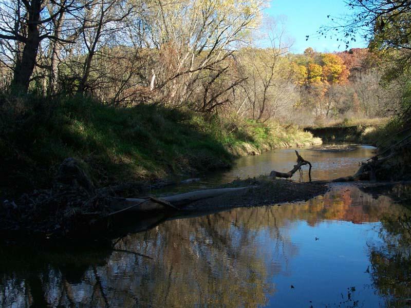
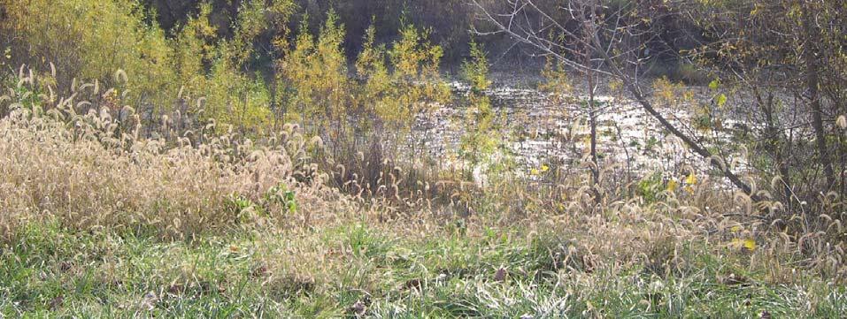
7 Ground-truthing/GPS-ing


8 Ground-truthing


9
10 UIUC- Habitat Fragmentation Model Identifies habitat required for certain species Provides habitat fragmentation analysis: Effect on habitat due to various economic trends Effect on habitat from land use change and public policy choices
11 Model Scenarios Business as usual (baseline economy/policies- no change) Economic Growth- 20% Gross Regional Product Economic Decline- loss of 15,000 jobs High Growth Contained- FPA (sewer service) High Growth Redirected- Ag. Preservation High Growth with Bluff Protection

 Wood")
12 Species for Model Bobcat (Canary in the Coal Mine) Wood Thrush

13 The Bobcat in Peoria Bobcat is a habitat generalist, not critically affected by fragmentation Bobcats are present in Peoria county - 3 recorded sightings - Medium abundance


14 Bobcat Habitat Essential habitat: Forest shrubland Hunting habitat: bare rock transitional orchards grassland pasture Wetlands

 Home range > 16 km 2 (high 18.")
15 Approach Combining the 3 themes that define bobcat habitat: Forest: > 1.89 km 2 (high 2.7, low 1.26) Core habitat > 2.4 km 2 (high 3.2, low 1.8) Home range > 16 km 2 (high 18.2 low 14.8) + + =
16 Current Bobcat Habitat

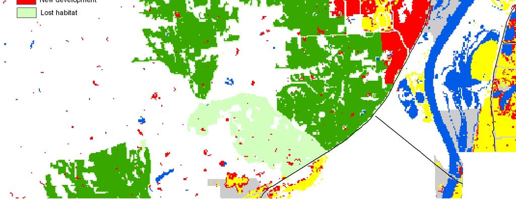
17 Future Habitat (FPA scenario) Loss of 1683 ha of essential habitat
18 Result in Detail

19 Result in Detail
20 Result in Detail

21 Result in Detail

22 Habitat Protection-Sustainable Development
23 Threatened Areas


24

25

26 Habitat Protection/Sustainable Development
27 Tier Development & Stats Tier 1: Area: 71, acres Parcels: 8,459 Land Use: mostly R1, in addition: A1, A2, C1 & C2 (few parcels), I1, I2, R1 & RR Parcels with 50% of Tier 1 coverage or more:
28 Tiers Stats Tier 2: Area: 10, acres Parcels: 5,049 Land Use: Mostly A2 & R2, in addition: A1, C2 (only 1 parcel), I2 (2 parcels), R1 & RR
29 Tiers Stats Tier 3: Area: 63, acres Parcels: 21,566 Land Use: the majority is A2 & R2; in addition to A1, R1, few parcels in C1, C2, I1, I2, RR & 17 parcels in R3

30 Tier Map Tier 1 = Red Tier 2= Yellow Tier 3= Blue
31 1 st Tier: Land Categories & Initial Recommendations Open Space by INAI sites and on floodplain Remain in natural state: Conservation Easements, Land & Water Reserves, Open Space County Ordinances 2 nd Tier: Areas linking above hubs, allowing connectivity Recommendations: Large Lot Development Conservation Development Natural Drainage
32 Land Categories & Recommendations 3 rd Tier: Sites in environmental corridors zoned or planned for development Recommendations: Stormwater Detention Natural Landscaping Floodplain Protection Topsoil Protection


33 Location Information Using GIS and intersecting resulting environmental corridors layer with parcel data to get complete location information
34 Deliverables & Next Phase Educational map of the Environmental Corridors + Website Land Use Guidelines Local Legacy Plan- Corridor Expansion Peoria County Environmental Corridor Ordinance- Transforming Tier Recommendations into formalized ordinance
Photo courtesy of George Wilmot
 Mattawoman project Genesis Proposed Cross County Connector Interest in developing an Ecosystem-based management approach to watershed resource protection Opportunity to influence the County Comprehensive
CHAPTER 8: INTERGOVERNMENTAL COOPERATION
 CHAPTER 8: INTERGOVERNMENTAL COOPERATION Photos above by Randy Uhl 8.1 Introduction Intergovernmental cooperation involves working with neighboring communities, school districts and agencies to understand
TAC CHARRETTE WORKBOOK Ecosystem Management and Sustainable Forestry Practices
 For Discussion Purposes TAC CHARRETTE WORKBOOK Ecosystem Management and Sustainable Forestry Practices NEW JERSEY HIGHLANDS COUNCIL March 28, 2006 1 Overview of RMP Goals and Structure NEW JERSEY HIGHLANDS
MIDDLE MISSISSIPPI RIVER (MMR) REGIONAL CORRIDOR
 REGIONAL CORRIDOR") MIDDLE MISSISSIPPI RIVER (MMR) REGIONAL CORRIDOR Illinois Missouri General Expense Project Proposal For Comprehensive Analyses of Multi-jurisdictional Use and Management of Water Resources on a Watershed
MIDDLE MISSISSIPPI RIVER (MMR) REGIONAL CORRIDOR Illinois Missouri General Expense Project Proposal For Comprehensive Analyses of Multi-jurisdictional Use and Management of Water Resources on a Watershed
LOWER DRUM PLANNING UNIT Yuba-Bear River Watershed
 Existing Conditions & Uses Overview Provides open space and recreation opportunities within the Sierra Nevada foothills 1,098 acres in Placer and Nevada Counties 789 acres outside the FERC boundary; 309
Natural Resources of Chatham
 Natural Resources of Chatham Andrew Meyer, Beth Roessler, Karen Strong, and Emily Vail NYSDEC Hudson River Estuary Program and Cornell University Presentation to Town of Chatham, December 6, 2012 The Hudson
APPENDIX M CEQA Initial Study Checklist
 APPENDIX M CEQA Initial Study Checklist Appendix G ENVIRONMENTAL CHECKLIST FORM (To be Completed by Applicant) 1. Project title: 2. Lead agency name and address: 3. Contact person and phone number: 4.
ENVIRONMENTAL FEATURES OF THE TOWN
 Town of Aurora Map 1 11 12 ENVRONMENTAL FEATURES TOPOGRAPY Maps 1 and 2 show the locations of important natural features of the Town of Aurora. Aurora is located in the Alleghany Plateau, a region of broad,
INDIAN CREEK WATERSHED PLAN EXECUTIVE SUMMARY
 INDIAN CREEK WATERSHED PLAN EXECUTIVE SUMMARY The Indian Creek Watershed covers a 38 square mile area in southern Lake County, Illinois that drains 24,116 acres before discharging into the Des Plaines
Conservation, Open Space & Groundwater Recharge Element
 Conservation, Open Space & Groundwater Recharge Element GOAL 1 ESTABLISH AND MAINTAIN AN INTEGRATED AND URBAN-DEFINING OPEN SPACE NETWORK THAT PROTECTS AND CONSERVES KEY ENVIRONMENTAL FEATURES. Objective
11. Prioritizing Farmlands for Future Protection
 11. Prioritizing Farmlands for Future Protection Identification of Important Farmlands in Putnam County I n order to implement this Plan successfully, Putnam County decision-makers will have to take advantage
Crow s Foot Conservation Area Feasibility Study
 Crow s Foot Conservation Area Feasibility Study Site Opportunities Presentation Trust For Public Land PRESENTED BY SmithGroup JJR August, 2002 McHenry County Conservation District Boone County Conservation
ORDINANCE APPENDIX C RUNOFF COEFFICIENTS AND CURVE NUMBERS
 ORDINANCE APPENDIX C RUNOFF COEFFICIENTS AND CURVE NUMBERS TABLE C-1. RUNOFF CURVE NUMBERS Source: Table 2-2a, Table 2-2b, and Table 2-2c from U. S. Department of Agriculture, Natural Resources Conservation
3 Baseline and Existing Conditions
 1 2 3 4 5 6 7 8 9 10 11 12 13 14 3 Baseline and Existing Conditions The effective date of the VSP legislation is July 22, 2011. This is also the date chosen by the legislature as the applicable baseline
Environmental Resource Inventories. What are ERIs? Significance of information How to use them
 Environmental Resource Inventories What are ERIs? Significance of information How to use them Environmental Resource Inventory - ERI Compiled by the environmental commission Information about the natural
8/5/2011. Lesson Overview. Disturbance/Fragmentation. Shifting Mosaic. Number one cause of biodiversity loss. Types of disturbance. - Scale, frequency
 Lesson Overview Disturbances Fragmentation Types Measuring Corridors Effects Texas Example 1 Shifting Mosaic Landscape a shifting mosaic. - Made up of patches in different phases of successional development.
Charlottesville Albemarle MPO:
 Charlottesville Albemarle MPO: Applying The Eco-Logical Approach To Small MPOs September 21, 2015 Charlottesville Albemarle Metropolitan Planning Organization (CAMPO) and The Thomas Jefferson Planning
Using A Connected Landscape Strategy to Conserve Virginia s Forests
 Using A Connected Landscape Strategy to Conserve Virginia s Forests Karen Firehock, Green Infrastructure Center Tomorrow Woods Workshop June 12, 2012 Session Route Natural Assets Assessment and Mapping
4 CONSERVED LANDS, PUBLIC LANDS, AND OTHER RECREATIONAL OPPORTUNITIES
 4 CONSERVED LANDS, PUBLIC LANDS, AND OTHER RECREATIONAL OPPORTUNITIES At the time of this study, there are approximately 2,300 acres of conservation land in Grantham, or 12% of the land area. The Town
Government Conservation Programs
 Government Conservation Programs Policy Resolutions Webinar 2017 Illinois Farm Bureau Governmental Affairs & Commodities Division Lyndsey Ramsey Assoc. Director of Natural and Environmental Resources CURRENT
Aquatic Resource Mitigation Fund
 Aquatic Resource Mitigation Fund Lori Sommer- Mitigation Program Coordinator Land Resource Management Program NH Department of Environmental Services PRESENTATION OVERVIEW Brief overview on mitigation
KANKAKEE COUNTY PLANNING DEPARTMENT APPLICATION FOR CLASS I & II GRADING AND DRAINAGE/STOMRWATER PERMIT APPLICATION
 KANKAKEE COUNTY PLANNING DEPARTMENT APPLICATION FOR CLASS I & II GRADING AND DRAINAGE/STOMRWATER PERMIT APPLICATION Michael J. Van Mill, AICP Planning Director 189 East Court Street Kankakee, IL 60901
Conservation Assessment of the Neuse River Lowgrounds and Mill Creek Watersheds in Johnston County
 Conservation Assessment of the Neuse River Lowgrounds and Mill Creek Watersheds in Johnston County Prepared by Leigh Ann Cienek and Jon Scott Triangle Land Conservancy Funding provided by the NC Attorney
TABLE OF CONTENTS. Introduction. Lower Platte South NRD Past and Present 1. Map of Lower Platte South NRD 2. Vision for the Future 3.
 TABLE OF CONTENTS Introduction ii Lower Platte South NRD Past and Present 1 Map of Lower Platte South NRD 2 Vision for the Future 3 Vision Table 5 i INTRODUCTION The Master Plan is the document that expresses
Figure 1: Preservation Area
 Figure 1: Figure 2: Land Use Capability Map Zones Regional Master Plan Overlay Zone Designation Zone Protection Lakes Greater Than 10 acres Conservation Existing Community Sub-Zone Existing Community Environmentally
Goose Creek Watershed Assessment Summary October 2003
 Goose Creek Watershed Assessment Summary October 2003 The Goose Creek Watershed The Goose Creek watershed is 385 square miles, covering nearly half of Loudoun County and one-quarter of Fauquier County
Webinar for the Natural Floodplain Function Alliance 18 November 2013
 Moving toward Floodplain Restoration at Scale on the Illinois River and Upper Mississippi Basin: Valuing Ecosystem Services, Demonstrating Flood Reduction, and Policy Implications Webinar for the Natural
Riparian Vegetation Protections. Heritage Tree Protection
 PLACER Protections in place: Oak Tree Retention/ Replacement Requirements General Plan Language Specific Voluntary Rural Design require preservation of native trees and groves through replacement and dedication
RECREATIONAL FARM FOR SALE acres in Sangamon County, Illinois
 320 S. Crossing Dr. P. O. Box 169 Sherman, IL 62684 217-496-3500 RECREATIONAL FARM FOR SALE 211. 42 acres in Sangamon County, Illinois Located five miles east of Springfield, Illinois In the middle of
District 12 - Lucas County Natural Resources Conservation Council Scoring Methodology =========================
 Project Name: Applicant: Project Scoring Summary 0 Part II Score: 0 of 44 points possible 0 Part III Score: 0 of 40 points possible 0 Part IV Score: 0 of 17 points possible Total Project Score: 0 of 101
Natural Resources and Climate Resiliency in Germantown
 Natural Resources and Climate Resiliency in Germantown Ingrid Haeckel, Andrew Meyer, and Elizabeth Murphy NYSDEC Hudson River Estuary Program and Cornell University Presentation to the Town of Germantown,
CREEKS OF THE MIDDLE FOX RIVER 2016 Progress Report
 CREEKS OF THE MIDDLE FOX RIVER 2016 Progress Report Brewster approximately three years after dam removal Presented by the Sierra Club Valley of the Fox Water Sentinels ILLINOIS CHAPTER PRESERVING THE FOX
SEPA Environmental Checklist
 WHATCOM COUNTY Planning & Development Services 5280 Northwest Drive Bellingham, WA 98226-9097 360-778-5900, TTY 800-833-6384 360-778-5901 Fax Mark Personius, AICP Director SEPA Environmental Checklist
PERMIT APPLICATION FEES Fees must be paid at time of application
 Permits SEPA Checklist Permit # Staff use Governmental agencies use this checklist to help determine whether the environmental impacts of your proposal are significant. This information is also helpful
APPENDIX J NRCS-CPA 106 Forms and Correspondence
 APPENDIX J NRCS-CPA 106 Forms and Correspondence Prepared For: Illinois Department of Transportation Indiana Department of Transportation Prepared By: Parsons Brinckerhoff July 2014 THIS PAGE INTENTIONALLY
PRESERVING THE KISHWAUKEE WATERSHED
 PRESERVING THE KISHWAUKEE WATERSHED Guiding development in the Marengo-Union region Executive Summary This project is funded through a grant from the Joyce Foundation Sponsored and funded by the City of
Buffalo Creek Watershed-Based Plan EXECUTIVE SUMMARY
 Buffalo Creek Watershed-Based Plan EXECUTIVE SUMMARY Prepared for Buffalo Creek Clean Water Partnership By Cardno August 2015 What you will find inside this Executive Summary 1. Introduction 2. Purpose
WQMP AMENDMENT REVIEW CHECKLIST
 State of New Jersey Highlands Water Protection and Planning Council 100 North Road (Route 513) Chester, New Jersey 07930-2322 (908) 879-6737 (908) 879-4205 (fax) www.highlands.state.nj.us WQMP AMENDMENT
Post-Development Stormwater Runoff Performance Standards
 Post-Development Stormwater Runoff Performance Standards December 9, 2014 Topics Why performance standards? What practices/requirements are in effect in other States? The Workgroup s preliminary and final
Lake County Stormwater Management Commission s Study of Post-Development Isolated Waters of Lake County, Illinois
 Lake County Stormwater Management Commission s Study of Post-Development Isolated Waters of Lake County, Illinois Application of the 80% - 150% Wetland Hydrology Design Criteria IAFSM March 2013 Background
SUMMARY OF MAJOR POLICY IMPLEMENTATION TOPICS From 2016 COUNTY Comprehensive Plan
 SUMMARY OF MAJOR POLICY IMPLEMENTATION TOPICS From 2016 COUNTY Comprehensive Plan A checkmark means that implementing code amendments have been drafted or are in progress as of November 1, 2016. Evaluate
Town of Sumner 2025 Comprehensive Plan
 2016 Update to: Planning Report 2025 Comprehensive Plan Jefferson County, Wisconsin October 2002 1 Page 1-4 Census Count Table 1-1 Population Trends 1970 2000; updated with 2010 Data # Change 1970 1980
Stormwater Management Tools: Real-Life Solutions for a Resilient Community Riparian Corridor Protection
 Stormwater Management Tools: Real-Life Solutions for a Resilient Community Riparian Corridor Protection Montgomery County Planning Commission October 24, 2013 Eric Jarrell, Assistant Section Chief, Community
U.S. Public Land Management Issues
 U.S. Public Land Management Issues Department of the Interior AGENCIES IN CHARGE OF US PUBLIC LANDS Department of Agriculture Bureau of Land Management National Park Service US Fish & Wildlife Service
BOSTON BAY HABITAT REHABILITATION AND ENHANCEMENT PROJECT (HREP) MERCER COUNTY, ILLINOIS
 MERCER COUNTY, ILLINOIS") BOSTON BAY HABITAT REHABILITATION AND ENHANCEMENT PROJECT (HREP) MERCER COUNTY, ILLINOIS UPPER MISSISSIPPI RIVER RESTORATION ENVIRONMENTAL MANAGEMENT PROGRAM ROCK ISLAND DISTRICT FACT SHEET I. LOCATION
BOSTON BAY HABITAT REHABILITATION AND ENHANCEMENT PROJECT (HREP) MERCER COUNTY, ILLINOIS UPPER MISSISSIPPI RIVER RESTORATION ENVIRONMENTAL MANAGEMENT PROGRAM ROCK ISLAND DISTRICT FACT SHEET I. LOCATION
Figure 1: P Area. Alpha Borough. Preservation Area Municipal Boundaries. Phillipsburg Town. Greenwich Township. Alpha Borough. Pohatcong Township
 Figure 1: P Area BOROUGH OF ALPHA Figure 2: Land Use Capability Map Zones Regional Master Plan Overlay Zone Designation Zone Protection Lakes Greater Than 10 acres Conservation Existing Community Sub-Zone
Forests of NYS. NYS Forest Usage RURAL NATURE OF NYS Eco-Regions Open Space Forests Wildlife. Forest Vegetation Zones. Forests Stats 4/13/2018
 17 - RURAL NATURE OF NYS Eco-Regions Open Space Forests Wildlife Forests of NYS Read the Forest Cover and Uses handout on the course home page. Prof. Anthony Grande Geography Dept. Hunter College-CUNY
Free Bridge Congestion Relief Project: Using FHWA s Eco-Logical Process
 Free Bridge Congestion Relief Project: Using FHWA s Eco-Logical Process An Ecosystem Approach to Developing Infrastructure Projects June 27, 2014 Charlottesville Albemarle Metropolitan Planning Organization
Figure 1: Preservation Area
 Figure 1: Figure 2: Land Use Capability Map Zones Regional Master Plan Overlay Zone Designation Zone Protection Lakes Greater Than 10 acres Conservation Existing Community Sub-Zone Existing Community Environmentally
Figure 1: Preservation Area
 Figure 1: Figure 2: Land Use Capability Map Zones Regional Master Plan Overlay Zone Designation Zone Protection Lakes Greater Than 10 acres Conservation Existing Community Sub-Zone Existing Community Environmentally
Marcellus Shale Gas Development in Maryland: A Natural Resource Analysis
 Marcellus Shale Gas Development in Maryland: A Natural Resource Analysis Advisory Commission Meeting February 27, 2012 Garrett County Economic Development map Catherine McCall Balancing Natural Resources
A PLANNER S S GUIDE FOR OAK WOODLANDS
 A PLANNER S S GUIDE FOR OAK WOODLANDS Prepared by The University of California Integrated Hardwood Range Management Program Fall, 2009 This Powerpoint presentation was prepared by the University of California
ANCR INDIVIDUAL RESPONSES SUMMARY: 2/11/04 WATER RESOURCES GOALS AND OBJECTIVES
 ANCR INDIVIDUAL RESPONSES SUMMARY: 2/11/04 WATER RESOURCES GOALS AND OBJECTIVES Goal 1: Protect the health and safety of the Dane County population. a. Prevent development that may have an adverse effect
The Cost of Green Infrastructure: Worth the Investment?
 University of Southern Maine USM Digital Commons Green Infrastructure New England Environmental Finance Center (NEEFC) 11-2013 The Cost of Green Infrastructure: Worth the Investment? Martha Sheils New
Natural Hazards Mitigation Plan Kankakee County, Illinois Executive Summary
 1. Introduction Natural Hazards Mitigation Plan Kankakee County, Illinois Executive Summary Kankakee County s first Natural Hazards Mitigation Plan was adopted by the Kankakee County Board on October 11,
Conservation District Business Plan Steuben County Soil and Water Conservation District
 Conservation District Business Plan Steuben County Soil and Water Conservation District I find the great thing in this world is not so much where we stand as in what direction we are moving Oliver Wendell
Conservation Planning. for Proactive Conservation. Nate Fuller Southwest Michigan Land Conservancy
 Conservation Planning for Proactive Conservation Nate Fuller Southwest Michigan Land Conservancy Conserving the scenic and ecologically important landscapes of southwest Michigan. Presettlement Vegetation
Protect forest lands from incompatible uses.
 GOAL 4: FOREST LANDS General Discussion To encourage conservation of forest lands in Klamath County for forest uses. Forest land shall be retained for the production of wood fiber and other forest uses.
Watershed Improvements
 Watershed Improvements Gwinnett County Georgia Association of Floodplain Managers March 14, 2013 Overview Watershed Assessment - 1998 to 2000 Watershed Protection Plan - 2000 Watershed Improvement Plans
St. Joseph River Watershed 319 Project Technical Subcommittee November 3, 2003 Meeting Summary DRAFT
 St. Joseph River Watershed 319 Project Technical Subcommittee November 3, 2003 Meeting Summary DRAFT Attendees Sandra Nordmark, FOTSJR Steve Blumer, USGS Water Resources Division Todd Kesselring, Elkhart
Sustainable Agricultural Land Conservation (SALC) Strategy. Butte County Planning Commission June 29, 2017
 Strategy. Butte County Planning Commission June 29, 2017") Sustainable Agricultural Land Conservation (SALC) Strategy Butte County Planning Commission June 29, 2017 Goals of Today s Workshop Describe the SALC project and work to date Demonstrate how Geographic
Sustainable Agricultural Land Conservation (SALC) Strategy Butte County Planning Commission June 29, 2017 Goals of Today s Workshop Describe the SALC project and work to date Demonstrate how Geographic
FINDINGS OF FACT And CONCLUSIONS
 FINDINGS OF FACT And CONCLUSIONS SOUTHWEST RECONNECTION PROJECT Highway 61/101 Flood Mitigation State Project No. 1009-24 and State Aid Project No. 010-661-002 Prepared for: Carver County September 2013
Draft Kane County 2040 Green Infrastructure Plan. Kane County Energy and Environment Committee October 10, 2013
 Kane County Energy and Environment Committee October 10, 2013 Natural Resources Advisers Mike Ander Ken Anderson Matt Bardol Steve Byers Seth Crackel Jerry Culp Sue Harney Russell Farnum Jane Holley Candice
Cannon River One Watershed, One Plan. POLICY COMMITTEE MEETING January 10, 2018 Rice County Government Center Faribault, MN
 Cannon River One, One Plan POLICY COMMITTEE MEETING January 10, 2018 Rice County Government Center Faribault, MN TASK Task 1. Aggregate Existing Physical & Spatial Data 1A. Create project maps 1B. Meeting
New Jersey Forest Stewardship Program Spatial Analysis Project Map Products And Data Layers Descriptions
 New Jersey Forest Stewardship Program Spatial Analysis Project 2007 Map Products And Data Layers Descriptions 01/07 NJ Forest Stewardship Program (FSP) Spatial Analysis Project (SAP) Methodology Project
Lake Creek Watershed Management Plan Public Meeting. Arrowhead Lake May 3, :00 PM
 Lake Creek Watershed Management Plan Public Meeting Arrowhead Lake May 3, 2018 6:00 PM Agenda I. Welcome and Introductions II. III. IV. Watershed Basics Overview of Lake Creek Watershed Elements of a Successful
Public Notice ISSUED: May 21, 2013 EXPIRES: June 20, 2013
 SPONSOR: REFER TO: Wisconsin Dept. of Transportation Public Notice ISSUED: May 21, 2013 EXPIRES: June 20, 2013 SECTION:404 - Clean Water Act 1. WETLAND COMPENSATORY MITIGATION BANK PROPOSAL 2. SPECIFIC
Figure 1: Preservation Area
 Figure 1: Figure 2: Land Use Capability Map Zones Regional Master Plan Overlay Zone Designation Zone Protection Lakes Greater Than 10 acres Conservation Existing Community Sub-Zone Existing Community Environmentally
Site Plan and Subdivision Review
 Site Plan and Subdivision Review Municipal Land Use Framework Environmental Resource Inventory Master Plan Zoning Land Use Regulation Ordinance requirements for each zone Lot size, setbacks parking, cluster
Inventory, Monitoring, and Research Efforts for Natural Resource Management on DoD Installations and USACE Project Lands
 Inventory, Monitoring, and Research Efforts for Natural Resource Management on DoD Installations and USACE Project Lands U.S. Army Corps of Engineers Engineer Research & Development Center - Environmental
City of Fairmont Storm Water Pollution Prevention Plan Annual Public Meeting. June 11, 2018
 City of Fairmont Storm Water Pollution Prevention Plan Annual Public Meeting June 11, 2018 Why is Water Quality Important? Water has always been important to Minnesota and is a key part of our history,
Wetland restoration and monitoring on the Chevelon Wildlife Area
 Wetland restoration and monitoring on the Chevelon Wildlife Area Michael Ingraldi, Ph.D. Research Branch Arizona Game and Fish Department Phoenix, Arizona 85023 The Chevelon State Wildlife Area is located
Nassau County 2030 Comprehensive Plan. Conservation Element (CS) Goals, Objectives and Policies. Goal
 Goals, Objectives and Policies. Goal") (CS) Goal Conserve, protect and enhance the natural resources that are important to the economy, health, and quality of life of County residents, ensuring that adequate resources are available for future
(CS) Goal Conserve, protect and enhance the natural resources that are important to the economy, health, and quality of life of County residents, ensuring that adequate resources are available for future
Terry Benoit 4/1/2009
 FRCRM FORUM FULL PROPOSAL SPANISH CREEK IN AMERICAN VALLEY Terry Benoit 4/1/2009 1. Project Name: Spanish Creek in American Valley 2. County: Plumas 3. Project Number: 4. Project Sponsor: Plumas Corporation
DEKALB COUNTY STORMWATER MANAGEMENT PLAN PHASE 2
 DEKALB COUNTY STORMWATER MANAGEMENT PLAN PHASE 2 Introduction DeKalb County, Illinois, located approximately 50 miles west of Lake Michigan, is rectangular in shape, with a north/south dimension of 36
FHWA s Eco-Logical Process: Uses in Performance-Based planning
 FHWA s Eco-Logical Process: Uses in Performance-Based planning August 25, 2014 Charlottesville Albemarle Metropolitan Planning Organization (CAMPO) and The Thomas Jefferson Planning District Commission
COUNTY COMPREHENSIVE PLAN
 86 : Policy Statement Lewis County has an abundance of natural resources, including water, wind, soils, and wildlife. Together with our citizens, they form a unique ecosystem that must be preserved and
TYPICAL CONTENTS OF A SITE-SPECIFIC NATURAL RESOURCE AND WOODLAND STAND DELINEATION MAP:
 TYPICAL CONTENTS OF A SITE-SPECIFIC NATURAL RESOURCE AND WOODLAND STAND DELINEATION MAP: A Site Context Map (1"=200') for vicinity within 1000' of the property Scale of map (to match scale of submitted
Nassau County 2030 Comprehensive Plan. Conservation Element (CS) Goals, Objectives and Policies. Goal
 Goals, Objectives and Policies. Goal") (CS) Goal Conserve, and protect and enhance the natural resources that are important to the economy, health, and quality of life of County residents, ensuring that adequate resources are available for
(CS) Goal Conserve, and protect and enhance the natural resources that are important to the economy, health, and quality of life of County residents, ensuring that adequate resources are available for
Adopted January 15, 1996 Hood River County Ordinance #201
 GOAL 3 AGRICULTURAL LANDS Adopted January 15, 1996 Hood River County Ordinance #201 A. GOAL: To preserve and maintain agricultural lands. B. POLICIES: 1. Agricultural land shall be preserved and maintained
Programmatic Environmental Assessment Forest-Wide Erosion Abatement USDA Forest Service Shawnee National Forest
 Programmatic Environmental Assessment Forest-Wide Erosion Abatement USDA Forest Service Shawnee National Forest Alexander, Gallatin, Hardin, Jackson, Johnson, Massac, Pope, Saline, Union and Williamson
Forests in the Farm Bill Coalition. Photo: David Harvey, Dixfield, Maine. Forest Priorities for the 2012 Farm Bill
 Forests in the Farm Bill Coalition Photo: David Harvey, Dixfield, Maine Forest Priorities for the 2012 Farm Bill January 2011 Congress and the Administration must work to ensure that the Farm Bill provides
LaPorte County Soil and Water Conservation District Business Plan
 LaPorte County Soil and Water Conservation District Business Plan 2011-15 LaPorte County Soil and Water Conservation District Business Plan 2011-2015 Who We Are: What We Do: Who We Serve: Our Mission:
2015 Reinvest in Minnesota (RIM) Reserve Wetlands Program
 Reserve Wetlands Program") 2015 Reinvest in Minnesota (RIM) Reserve Wetlands Program Site Evaluation Form Instructions Document 12/31/14 This instructions document is to be used for guidance in completing the Site Evaluation Form
2015 Reinvest in Minnesota (RIM) Reserve Wetlands Program Site Evaluation Form Instructions Document 12/31/14 This instructions document is to be used for guidance in completing the Site Evaluation Form
Inventory of Management Programs
 Appendix C Salmon Recovery Plan Inventory of s Table 1 Inventory of management programs, sponsors or agencies, area affected by the programs, goal of the programs, and a determination whether the program
CITY OF SNOHOMISH 116 UNION AVENUE SNOHOMISH, WASHINGTON (360)
") CITY OF SNOHOMISH 116 UNION AVENUE SNOHOMISH, WASHINGTON 98290 (360) 568 3115 WWW.SNOHOMISHWA.GOV STATE ENVIRONMENTAL POLICY ACT (SEPA) CHECKLIST PURPOSE OF CHECKLIST The State Environmental Policy Act
CITY OF SNOHOMISH 116 UNION AVENUE SNOHOMISH, WASHINGTON 98290 (360) 568 3115 WWW.SNOHOMISHWA.GOV STATE ENVIRONMENTAL POLICY ACT (SEPA) CHECKLIST PURPOSE OF CHECKLIST The State Environmental Policy Act
Kern County Environmental Checklist Form Environmental Factors Potentially Affected
 Kern County Environmental Checklist Form Environmental Factors Affected The environmental factors checked below would be potentially affected by this project, involving at least one impact that is a potentially
V. Conservation Element. Goals, Objectives and Policies
 V. Conservation Element Goals, Objectives and Policies V. Conservation Element GOAL V-1: PROVIDE FOR THE MANAGEMENT, ENHANCEMENT AND PROTECTION OF THE NATURAL RESOURCES OF GLADES COUNTY. OBJECTIVE V-1.1:
Bear River Planning Unit. Fish, Plant, and Wildlife Habitat BEAR RIVER PLANNING UNIT
 BEAR RIVER PLANNING UNIT Yuba-Bear River Watershed Bear River Planning Unit Above all, the Stewardship Council recommends close coordination with the upcoming relicensing effort to ensure consistency with
PEACE RIVER MANASOTA REGIONAL WATER SUPPLY AUTHORITY Orange Hammock Ranch Conservation Fact Sheet
 PEACE RIVER MANASOTA REGIONAL WATER SUPPLY AUTHORITY Orange Hammock Ranch Conservation Fact Sheet Authority s Regional Water Supply Infrastructure The RV Griffin Reserve (RVG) property is owned by the
STREAM RESTORATION PURPOSE, PRACTICE, AND METHODS. By Marcus Rubenstein, CPESC
 STREAM RESTORATION PURPOSE, PRACTICE, AND METHODS By Marcus Rubenstein, CPESC WHAT IS STREAM RESTORATION? The return of a stream s lost natural functions, usually resulting from watershed alterations,
USDA and other Government Agency efforts to Enhance Soil and Water Conservation
 USDA and other Government Agency efforts to Enhance Soil and Water Conservation USDA-NRCS The Natural Resource Conservation Service (NRCS) was originally the Soil Conservation Service (SCS) SCS Created
Section 3 Current and Future Water Demand
 Understanding the magnitude and location of future water demands, and any potential changes from existing water demands, allows the County to develop recommendations that will meet or manage demands for
The total population of the township is 9,942 (2015 Five-Year American Community Survey [ACS]). The median household income is over $109,000.
![The total population of the township is 9,942 (2015 Five-Year American Community Survey [ACS]). The median household income is over $109,000.](/thumbs/72/67990406.jpg "The total population of the township is 9,942 (2015 Five-Year American Community Survey [ACS]). The median household income is over $109,000.") East Bradford Township, Pennsylvania Motivated by watershed impairment caused by suburban development over the past 30 years, a township with a full slate of water quality improvement programs looks outside
East Bradford Township, Pennsylvania Motivated by watershed impairment caused by suburban development over the past 30 years, a township with a full slate of water quality improvement programs looks outside
Hickory Creek 319 grant project City of Denton
 Hickory Creek 319 grant project City of Denton Kenneth Banks, Division of Environmental Quality, City of Denton PREPARED IN COOPERATION WITH THE TEXAS COMMISSION ON ENVIRONMENTAL QUALITY AND U.S. ENVIRONMENTAL
Public Notice ISSUED: 5/6/2014 EXPIRES: 6/5/2014
 APPLICANT: Kinghorn Company / Scannell Properties Public Notice ISSUED: 5/6/2014 EXPIRES: 6/5/2014 REFER TO: 2014-00724-MMJ SECTION:404 - Clean Water Act 1. APPLICATION FOR PERMIT TO discharge fill material
EXECUTIVE SUMMARY DES PLAINES RIVER WATERSHED-BASED PLAN WHY A WATERSHED-BASED PLAN? WHAT IS A WATERSHED?
 Des Plaines River Watershed-Based Plan EXECUTIVE SUMMARY June 2018 EXECUTIVE SUMMARY DES PLAINES RIVER WATERSHED-BASED PLAN WHY A WATERSHED-BASED PLAN? Water is elemental to our lives. Plants and animals,