Application of Rainfall-runoffinundation. Pampanga River Basin
|
|
|
- Joy Stewart
- 5 years ago
- Views:
Transcription
 Hilario Larry Esperanza (ARFFWC) Philippine Atmospheric, Geophysical & Astronomical Services Administration")
1 ADB-ICHARM: Training Program on Flood Inundation Analysis (Nov 2012) Application of Rainfall-runoffinundation (RRI) Model to the Pampanga River Basin Hilton Hernando () Hilario Larry Esperanza (ARFFWC) Philippine Atmospheric, Geophysical & Astronomical Services Administration (PAGASA)
2 ADB-ICHARM: Training Program on Flood Inundation Analysis (Nov 2012) Presentation Outline Brief on Pampanga River Basin Pampanga River Flood Forecasting & Warning System (PRFFWS) Event: Typhoon Pedring (Nesat) September 2011 and Southwest Monsoon of August 2012 RRI Model as applied to PRB event/s Calibration - Sept 2011 Validation - August 2012 Way Forward Programs (Challenges, Priorities & Opportunities other related activities) Other matters
 The PAMPANGA")
3 ADB-ICHARM: Training Program on Flood Inundation Analysis (Nov 2012) The PAMPANGA RIVER BASIN
 Provinces within the PAMPANGA")
4 ADB-ICHARM: Training Program on Flood Inundation Analysis (Nov 2012) Provinces within the PAMPANGA RIVER BASIN
5 ADB-ICHARM: Training Program on Flood Inundation Analysis (Nov 2012) PRB: About 90 towns and 7 cities within the basin area.


6 PAMPANGA RIVER Basin MAIN TRIBUTARIES ADB-ICHARM: Training Program on Flood Inundation Analysis (Nov 2012) TALAVERA RIVER CARRANGLAN RIVER PANTABANGAN RIVER ILOG BALIWAG RIVER MURCON RIVER PAMPANGA RIVER BASIN DIGMALA RIVER CORONEL RIVER CABU RIVER Minatula River SIU RIVER QUITANGUIL RIVER CAAGASAN RIVER TABUATING RIVER Tambo River PEÑARANDA RIVER BULO RIVER RIO CHICO RIVER GARLANG RIVER MAASIM RIVER Manila Bay MANILA ANGAT RIVER


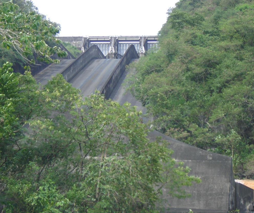
7 PAMPANGA RIVER Basin Flood Structures ADB-ICHARM: Training Program on Flood Inundation Analysis (Nov 2012)
8 PAMPANGA RIVER BASIN: THE NEED FOR FFWS At least 1 flooding a year Frequency of TC: about 5 in 3 years Very pronounced SW monsoon Relatively low elevation / flat terrain Narrow (some sections) and silted waterways Flood prone area: about 2,200 km 2 (Pampanga) & 400 km 2 (Pasac-Guagua) 2 Swamp areas Candaba & San Antonio 2 major Dam structures Angat & Pantabangan (Reported) slow sinking of the Pampanga Delta
9 ADB-ICHARM: Training Program on Flood Inundation Analysis (Nov 2012) FLOOD SITUATION within PRB


10
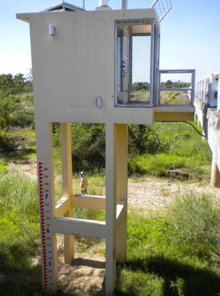
11 River overflowing

12 Some flashy tributaries

13 Floods from Dam releases

14 Other flooding issues within the basin: Coastal Floods (due to high tide)

15 A non-structural flood mitigating measure
16 Pampanga River Flood Forecasting & Warning System ADB-ICHARM: Training Program on Flood Inundation Analysis (Nov 2012) 1973 March 19, RR & 10 WL stns Monitoring Ctr in SFDO Telemetry system FFWSDO thru FFWS, Q.C. MOC Operational 24 / 7 5 personnel

")
17 Upstream rainfall station in Gabaldon, N.E. (Coronel River) (Eastside)
18 On the upper side (Northeast), Pampanga River starts at Pantabangan Dam

19 Calaanan Rainfall station (Digmala watershed) ADB-ICHARM: Training Program on Flood Inundation Analysis (Nov 2012)

20 Coronel River joins with Pampanga River before Sapang Buho station

21 Sapang Buho RR-WL 2009


22 Pampanga River at Mayapyap stn.

")


23 Penaranda River (East area) joins Pampanga R. before San isidro

24 Pampanga River at San Isidro


25 Rio Chico River at the NW part of the basin


26 Pampanga river at Arayat ADB-ICHARM: Training Program on Flood Inundation Analysis (Nov 2012)

27 Candaba swamp area

28 Candaba station

29 Candaba at flood season

30 Sulipan station

")
31 Mexico stn. (Abacan River)


32 Sasmuan stn. (Pasac-Guagua River System)
33 Event: Typhoon Pedring (Nesat) September 2011

34 Typhoon Pedring (Nesat)

35

36

37

38

39
40

")
41 Typhoon Pedring (Sept 2011)

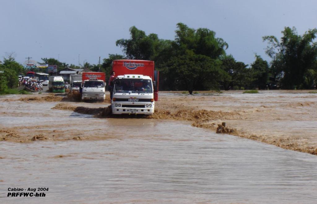
42 Typhoon Pedring (Sept 2011)

")


43 Typhoon Pedring (Sept 2011)

")

44 Typhoon Pedring (Sept 2011)
45 RRI calibration: PRB September 2011 flood event

46 ARCGIS PROGRAM: DOWNLOAD THE HYDROSHEDS DATA EXTRACT USING MASK TO MAKE A RASTER FILE
47 ARCGIS PROGRAM: ADB-ICHARM: Training Program on Flood Inundation Analysis (Nov 2012) * THE RESULT RASTER FILE OF PAMPANGA PAMPANGA DEM PAMPANGA DIR PAMPANGA ACC

48 RASTER FILE TO ASCII FILE AT THE ARCTOOL BOX USING THE CONVERSION TOOLS WE CONVERT THE RASTER FILE TO ASCII FILE OUTPUT FILE: PAMPANGA.TXT (DEM, ACC, DIR)
49 RRI model simulation
50 RRI model simulation
51 RRI model simulation
52 RRI model simulation
53 RRI model simulation
54 RRI model simulation

55 Some comparative results Flood started at around 0900H 1000H, Sept. 27, 2012 at Digmala Coronel rivers
56 Some comparative results Cabiao Floodway not passable starting around 11AM of 28 Sept and for the next 3-4 days

57

58
59 Event: Southwest Monsoon August 2012

60

61

62
63 RRI validation: PRB August 2012 flood event
64 PRB: Inundation extent of August 2012 flood
65 Way forward Programs: Challenges, Priorities & Opportunities other related activities
66 Way forward activities (for now) Technical report on the application of RRI in the PRB (Sept 2011 & Aug 2012 events) Echo seminar to basin personnel RRI basic operational application procedural suite for Philippine situation Application of RRI model In the PRB (future flood events) forecasting mode Agno River Basin Other Basins in the Philippines (if possible) Enhancement of Parameters grouped into similar events

67
The Pampanga River Basin Flood Forecasting & Warning System (PRFFWC) the pilot FFW System in the Philippines
 the pilot FFW System in the Philippines") Asian Water Cycle Symposium 2016, University of Tokyo, Japan (March 1-2, 2016) The Pampanga River Basin Flood Forecasting & Warning System () the pilot FFW System in the Philippines H. T. Hernando, PAGASA
Asian Water Cycle Symposium 2016, University of Tokyo, Japan (March 1-2, 2016) The Pampanga River Basin Flood Forecasting & Warning System () the pilot FFW System in the Philippines H. T. Hernando, PAGASA
Support in Community of Practice. Proposal of Evidence-based Flood Contingency Planning
 Support in Community of Practice Proposal of Evidence-based Flood Contingency Planning M. OHARA, N. NAGUMO, B. B. SHRESTHA and H.SAWANO International Centre for Water Hazard and Risk Management (ICHARM),
PAGASA and its Flood Early Warning Services. HydroMeteorology Division (HMD)
") and its Flood Early Warning Services HydroMeteorology Division (HMD) HYDROMETEOROLOGY DIVISION ( HMD) (Formerly Flood Forecasting Branch, FFB) WATER-RELATED DISASTER MITIGATION MEASURES MEASURES STRUCTURAL
and its Flood Early Warning Services HydroMeteorology Division (HMD) HYDROMETEOROLOGY DIVISION ( HMD) (Formerly Flood Forecasting Branch, FFB) WATER-RELATED DISASTER MITIGATION MEASURES MEASURES STRUCTURAL
Investigating the Impact of Climate Change on Flooding in the Sittaung River Basin, Myanmar
 Investigating the Impact of Climate Change on Flooding in the Sittaung River Basin, Myanmar Su Su Kyi * MEE1673 Supervisor: Assoc. Prof. Mohamed Rasmy** Prof. Toshihiro Koike** Dr. Duminda Perera** ABSTRACT
Summary of Preparatory Study for Development Study (M/P)
") Summary of Preparatory Study for Development Study (M/P) 1. Title of the Cooperation Project The Study on Integrated Water Resources Management for Poverty Alleviation and Economic Development in the Pampanga
Summary of Preparatory Study for Development Study (M/P) 1. Title of the Cooperation Project The Study on Integrated Water Resources Management for Poverty Alleviation and Economic Development in the Pampanga
Institutional Challenges, Scientific Opportunities
 Managing Urban Climate Risks: Institutional Challenges, Scientific Opportunities Shiv Someshwar and Esther Conrad IRI/Earth Institute, Columbia University Mihir Bhatt All India Disaster Mitigation Institute,
Climate Risks and Adaptation in Asian Coastal Megacities
 Climate Risks and Adaptation in Asian Coastal Megacities Local Climate Solutions for Africa 2011, ICLEI, Cape Town Poonam Pillai Sr. Environmental Specialist World Bank Presentation based on joint WB,
Proposal Report. Flood Hazard Mapping Project. City of San Fernando (P)
") Proposal Report on Flood Hazard Mapping Project in City of San Fernando (P) Prepared By DE LEON Efren Mariano Engineer IV City Engineer s Office City of San Fernando, Pampanga Philippines FLOOD HAZARD
Proposal Report on Flood Hazard Mapping Project in City of San Fernando (P) Prepared By DE LEON Efren Mariano Engineer IV City Engineer s Office City of San Fernando, Pampanga Philippines FLOOD HAZARD
Proposal Report. Flood Hazard Mapping Project in. Singhaburee Municipal, Singhaburee province Thailand. Prepared By. Mr. Phadungsak PHACHAROEN
 Proposal Report on Flood Hazard Mapping Project in Singhaburee Municipal, Singhaburee province Thailand Prepared By Mr. Paitoon NAKTAE Mr. Phadungsak PHACHAROEN Ms.Pilailak AKSORNRAT JICA Region Focused
Distribution of Elevation Zones in the Study Area ANF-2-1
 Annex-Figures Annex-F 2.1.1 Distribution of Elevation Zones in the Study Area ANF-2-1 Annex-F 2.1.2 Distribution of Slope Category in the Study Area ANF-2-2 Annex-F 2.2.1 Principal Sub-basins in the Study
Title Action Plan toward Effective Flood Hazard Mapping in My Country
 Title Action Plan toward Effective Flood Hazard Mapping in My Country JICA region focused training course on flood hazard mapping Sep 2006 LAI TUAN ANH Division of Geodesy Department of Planning and Management
ICHARM's activities on water-related disaster and flood management in Asia (Cases of Philippines, Myanmar and Sri Lanka)
") ICHARM's activities on water-related disaster and flood management in Asia (Cases of Philippines, Myanmar and Sri Lanka) Tetsuya IKEDA, PhD Chief Researcher ICHARM (International Centre for Water Hazard
ICHARM's activities on water-related disaster and flood management in Asia (Cases of Philippines, Myanmar and Sri Lanka) Tetsuya IKEDA, PhD Chief Researcher ICHARM (International Centre for Water Hazard
WATER-RELATED HAZARDS AND DISASTER RISK IN CAGAYAN RIVER BASIN, PHILIPPINES
 WATER-RELATED HAZARDS AND DISASTER RISK IN CAGAYAN RIVER BASIN, PHILIPPINES Orlando F. Balderama PWRI ICHARM Meeting November 16, 2018 FURUMAI LABORATORY One dead in Isabela town flood during 'Rosita'
ICHARM s contribution on water-related disaster risk reduction in Asia and the world
 ICHARM s contribution on water-related disaster risk reduction in Asia and the world Tetsuya IKEDA, PhD International Centre for Water Hazard and Risk Management under the auspices of UNESCO (ICHARM) October
Interaction Between Philippine Met Services and Corn Farmers in the Southern Philippines
 Interaction Between Philippine Met Services and Corn Farmers in the Southern Philippines C. Predo, R. de Guzman, E. Juanillo, P. Hayman, C. Reyes, E. Monte, K. Gonzales, R. Patindol, R. Gravoso, J. Liguton,
SAN BERNARD RIVER WATER QUALITY MODEL UPDATE. August 18, 2011
 SAN BERNARD RIVER WATER QUALITY MODEL UPDATE August 18, 2011 Agenda Model Set-up Watershed model Watershed delineations Generate model input files & establish coefficients Receiving Water model Establish
FLOOD MANAGEMENT IN THE RED THAI BINH RIVER BASIN VIET NAM
 FLOOD MANAGEMENT IN THE RED THAI BINH RIVER BASIN VIET NAM By Dr. To Trung Nghia Director of Institute of Water Resources Planning Chief of the Red Thai Binh RBO Office E-mail: iwrp.hanoi@hn.vnn.vn INTRODUCTION
AWCS 2016 Flood Session: Towards IFI-AP - ICHARM 10th anniversary - Flood Early Warning System (Presentations & Discussion)
") AWCS 2016 Flood Session: Towards IFI-AP - ICHARM 10th anniversary - Flood Early Warning System (Presentations & Discussion) 45 minutes March 1, 2016 Flood Early Warning System session - Agenda - Presentations
AWCS 2016 Flood Session: Towards IFI-AP - ICHARM 10th anniversary - Flood Early Warning System (Presentations & Discussion) 45 minutes March 1, 2016 Flood Early Warning System session - Agenda - Presentations
RAINFALL RUNOFF MODELLING AND INUNDATION ANALYSIS OF BAGMATI RIVER AT TERAI REGION OF NEPAL
 RAINFALL RUNOFF MODELLING AND INUNDATION ANALYSIS OF BAGMATI RIVER AT TERAI REGION OF NEPAL Baral MITRA Supervisor: Prof. A.W. Jayawardena** MEE07179 ABSTRACT Climatic variability, unplanned land use pattern
WOMEN IN ILBM : THE PHILIPPINES EXPERIENCE
 WOMEN IN ILBM : THE PHILIPPINES EXPERIENCE Adelina C. Santos-Borja Member, ILEC Scientific Committee Chief, Research and Development Division Head, Carbon Finance Unit Laguna Lake Development Authority
H.3 Water Balance Study
 Sector H: Water Resources Development and Management H.3 Water Balance Study H.3.1 Water Resources Potential H.3.1.1 Surface Water Resources Potential (1) General Water resources potential in a quasi-natural
John Louie FABILA, Ma. Rosario Concepcion ANG, and Girlie DAVID, Philippines. Key words: flood hazard, risk management, climate change SUMMARY
 Assessing the Increase in Exposure to Flood Hazard of Critical River Systems Due to Climate Change by Integrating Predicted Change in Rainfall Scenarios Based on Global Circulation Models John Louie FABILA,
Philippines 3W: Typhoon Nesat ("Pedring") and Typhoon Nalgae ("Quiel") On-going and Planned Activities in Bulacan and Pampanga as of 13 October 2011
 and Typhoon Nalgae (Quiel) On-going and Planned Activities in Bulacan and Pampanga as of 13 October 2011") Philippines 3W: Typhoon Nesat ("Pedring") and Typhoon Nalgae ("Quiel") On-going and Planned Activities in Bulacan and Pampanga CAPAS Legend BAMBAN Provincial boundary MAGALANG CABIAO SAN ISIDRO GAPAN GENERAL
Philippines 3W: Typhoon Nesat ("Pedring") and Typhoon Nalgae ("Quiel") On-going and Planned Activities in Bulacan and Pampanga CAPAS Legend BAMBAN Provincial boundary MAGALANG CABIAO SAN ISIDRO GAPAN GENERAL
ICELANDIC RIVER / WASHOW BAY CREEK INTEGRATED WATERSHED MANAGEMENT PLAN STATE OF THE WATERSHED REPORT CONTRIBUTION SURFACE WATER HYDROLOGY REPORT
 ICELANDIC RIVER / WASHOW BAY CREEK INTEGRATED WATERSHED MANAGEMENT PLAN STATE OF THE WATERSHED REPORT CONTRIBUTION SURFACE WATER HYDROLOGY REPORT Disclaimer: The hydrologic conditions presented in this
FLOOD MANAGEMENT IN THE RED THAI BINH RIVER BASIN
 FLOOD MANAGEMENT IN THE RED THAI BINH RIVER BASIN 1. INTRODUCTION OF THE RED THAI BINH RIVER BASIN The Red Thai Binh river basin (RRB) is situated at 20 to 30 30 of the north latitude, 100 to 107 10 of
Project Title : A FLOOD FORECASTING DEVICE IN QUEZON CITY, PHILIPPINES: A SOUND PRACTICE FOR FLOOD DISASTERS REDUCTION MEASURE
 Project Title : A FLOOD FORECASTING DEVICE IN QUEZON CITY, PHILIPPINES: A SOUND PRACTICE FOR FLOOD DISASTERS REDUCTION MEASURE Organization : California Riverside and Odelco Compound, Barrio (Bgy.) San
2011/9/ Principal rivers (421 river basins) 18 major river basins (with drainage area greater. 72 lakes Extensive groundwater aquifers
 18 major river basins (with drainage area greater. 72 lakes Extensive groundwater aquifers") VICENTE B. TUDDAO, JR., Ph.D. Executive Director River Basin Control Office Department of Environment and Natural Resources Mandarin Oriental Hotel Makati City, Metro Manila September 21, 2011 421 Principal
VICENTE B. TUDDAO, JR., Ph.D. Executive Director River Basin Control Office Department of Environment and Natural Resources Mandarin Oriental Hotel Makati City, Metro Manila September 21, 2011 421 Principal
DEVELOPMENT OF FLOOD INUNDATION MAP FOR BAGO RIVER BASIN USING DIFFERENT MODELS. Presented by. Dr.Win Win Zin Professor YTU
 DEVELOPMENT OF FLOOD INUNDATION MAP FOR BAGO RIVER BASIN USING DIFFERENT MODELS Presented by Dr.Win Win Zin Professor YTU 26 th Sept 2018 INTRODUCTION Flood inundation modeling involves hydrologic modeling
South-East Asia Flood Risk Reduction Forum
 UNITED NATIONS ECONOMIC AND SOCIAL COMMISSION FOR ASIA AND THE PACIFIC South-East Asia Flood Risk Reduction Forum 20 February 2012, Bangkok, Thailand By: TES Sopharith Senior Hydrologist Department of
The University of Texas at Austin Department of Civil, Architectural and Environmental Engineering
 The University of Texas at Austin Department of Civil, Architectural and Environmental Engineering CE 394K.3: Geographic Information Systems in Water Resources Engineering Fall 2015 Term Project Flooding
What we are looking for through utilizing the global earth observation. 14 January 2012 Japan International Cooperation Agency (JICA) Yusuke AMANO
 Yusuke AMANO") What we are looking for through utilizing the global earth observation 14 January 2012 Japan International Cooperation Agency (JICA) Yusuke AMANO 1 Outline To clarify what sort of data are to be monitored
What we are looking for through utilizing the global earth observation 14 January 2012 Japan International Cooperation Agency (JICA) Yusuke AMANO 1 Outline To clarify what sort of data are to be monitored
Proposal for application of FHM in Lao PDR: Case of Nam Ngum River Basin
 Proposal for application of FHM in Lao PDR: Case of Nam Ngum River Basin I. Nam Ngum River and Its Basin Nam Ngum River Basin is of vital importance to the Lao PDR, it is considered as the food house of
Hydrologic forecasting for flood risk management Predicting flows and inundation in data-limited catchments
 Hydrologic forecasting for flood risk management Predicting flows and inundation in data-limited catchments Dr. Kelly Kibler Assistant professor Civil, Environmental, & Construction Engineering University
Water Related Challenges in Asia - A Tale Of Three Cities -
 Water Related Challenges in Asia - A Tale Of Three Cities - St. Regis Hotel Washington DC 17 October, 2014 Keizrul bin Abdullah Chairperson Network of Asian River Basin Organizations (NARBO) 3 Case Studies
Evaluation of flood volume and inundation depth by GIS midstream of Chao Phraya River Basin, Thailand
 Sustainable Development, Vol. 2 1049 Evaluation of flood volume and inundation depth by GIS midstream of Chao Phraya River Basin, Thailand T. C. Cham, Y. Mitani, K. Fujii & H. Ikemi Graduate School of
AIACC Regional Study AS07: Southeast Asia Regional Vulnerability to Changing Water Resource and Extreme Hydrological Events due to Climate Change
 AIACC Regional Study AS07: Southeast Asia Regional Vulnerability to Changing Water Resource and Extreme Hydrological Events due to Climate Change Progress report: period mid-year 2003 Brief Summary: In
Angat Water Transmission Improvement Project
 Angat Transmission Improvement Project Updated on October 29, 2018 Region III Central Luzon PhP 3.3 billion ADB Cooperativa Muratori and Cementisti Construction started October 26, 2016 Target completion
CENTRAL ASSINIBOINE INTEGRATED WATERSHED MANAGEMENT PLAN SURFACE WATER HYDROLOGY REPORT
 CENTRAL ASSINIBOINE INTEGRATED WATERSHED MANAGEMENT PLAN SURFACE WATER HYDROLOGY REPORT Planning Area Boundary: The Central Assiniboine planning area covers the reach of the Assiniboine River from just
BASIC STUDY FOR NON- STRUCTURAL DISASTER PREVENTION MEASURES
 4 th th WORLD WATER FORUM Mexico City, Mexico March 21, 2006 BASIC STUDY FOR NON- STRUCTURAL DISASTER PREVENTION MEASURES Camiguin,, Philippines Dolores Mayor Hipolito Project Manager II Flood Control
Hydrological Feedbacks in Tropical African Wetlands
 Hydrological Feedbacks in Tropical African Wetlands Simon Dadson University of Oxford (simon.dadson@ouce.ox.ac.uk) Key challenges Linking across scales: can we predict the hydrological response to climate
Effects of climate change on streamflow in Kon Ha Thanh river watershed, Vietnam
 EPiC Series in Engineering Volume 3, 2018, Pages 2233 2240 Engineering HIC 2018. 13th International Conference on Hydroinformatics Effects of climate change on streamflow in Kon Ha Thanh river watershed,
Flood Hazard Mapping Project in Huong River Basin of Thua Thien Hue Province
 Proposal Report on Flood Hazard Mapping Project in Huong River Basin of Thua Thien Hue Province Prepared by PHAM Viet Tien Center for Application of Hydro-meteorological Technology (belong to National
ACTION PLAN TOWARD EFFECTIVE FLOOD HAZARD MAPPING IN CAMBODIA
 CONCLUDING REPORT On ACTION PLAN TOWARD EFFECTIVE FLOOD HAZARD MAPPING IN CAMBODIA Prepared by: HORN SOVANNA Chief Office of Hydrology Works Department of Hydrology and River Works (DHRW) Ministry of Water
Linking Corn Production, Climate Information and Farm-Level Decision-Making: A Case Study in Isabela, Philippines
 Chapter 16 Linking Corn Production, Climate Information and Farm-Level Decision-Making: A Case Study in Isabela, Philippines 16.1 Introduction Corn is the second most important crop in the Philippines
Flood Analysis: Hydrologic Principles & Analysis. Charles Yearwood. Drainage Unit, Ministry of Public Works Sept 2007
 Flood Analysis: Hydrologic Principles & Analysis. Charles Yearwood Drainage Unit, Ministry of Public Works Sept 2007 Research interest: Hydrologic data collection; Early warning systems; & Integrated flood
ARANGKADA PHILIPPINES 2010: A BUSINESS PERSPECTIVE. Infrastructure: Water
 Infrastructure: Water Sector Background and Potential The dependable supply and distribution of water for urban living as well as agriculture is critical to economic growth and the everyday life of Filipinos.
The Report of the East Asian Seas Congress in Manila, Philippines -Partnerships At Work : Local Implementation and Good Practices
 IGU-Commission on Hazard and Risk 2008-2012 Commission Shigeko HARUYAMA, Chair The Report of the East Asian Seas Congress in Manila, Philippines -Partnerships At Work : Local Implementation and Good Practices
GEOSS-Asian Water Cycle Initiative (AWCI) Flood WG - Activity Report -
 Flood WG - Activity Report -") GEOSS-Asian Water Cycle Initiative (AWCI) Flood WG - Activity Report - Kazu FUKAMI (ICHARM) Srikantha HERATH (UNU) 6 th International Coordination Group (ICG) Meeting, 13 March 2010 1 Flood WGs and relevant
GEOSS-Asian Water Cycle Initiative (AWCI) Flood WG - Activity Report - Kazu FUKAMI (ICHARM) Srikantha HERATH (UNU) 6 th International Coordination Group (ICG) Meeting, 13 March 2010 1 Flood WGs and relevant
OPTIMIZATION OF DAM OPERATION FOR.
 Kochi University of Technology Aca OPTIMIZATION OF DAM OPERATION FOR Title ER USE AND FLOOD PREVENTION: A CA,PHILIPPINES JARANILLA-SANCHEZ, Patricia Ann, Author(s) KOIKE, Toshio Society for Social Management
Remote Sensing Applications for Flood Management in ADB TA8074-REG
 Remote Sensing Applications for Flood Management in ADB TA8074-REG Presentation by Yusuke Muraki Infrastructure Specialist (Space Technology) Asian Development Bank 20 November 2014 1 Contents Share the
The City of Manila Manila experienced colonial eras under Spain, the United States, etc. but in 1946 it gained independence and due to the influx of
 The City of Manila Manila experienced colonial eras under Spain, the United States, etc. but in 1946 it gained independence and due to the influx of population resulting from urbanization and the high
Flood Modelling For Peri Urban Areas in Adyar River
 Flood Modelling For Peri Urban Areas in Adyar River Saranya VP 1 Assistant Professor, Department of Civil Engineering, Bannari Amman Institute of Technology, Erode, India 1 ABSTRACT: Water is essential
Vulnerabilities to Climate Change Impacts and Strengthening Disaster Risk Management in East Asian Cities
 Hanoi, Vietnam 2008 Primer Reducing Vulnerabilities to Climate Change Impacts and Strengthening Disaster Risk Management in East Asian Cities I/ CITY DESCRIPTION A. Hanoi Topography and demography characteristics
For which applications/questions will the IDSS be used?
 139 Integrated Decision Support System 付属資料 3 140 For which applications/questions will the IDSS be used? General: CONSERVING and PROTECTING the COASTAL ENVIRONMENT Regulating aquaculture/mariculture activities
Signing ceremony JAPAN-ASEAN Joint-Research Center
 Ali Yuzir Deputy Director, Disaster Preparedness & Prevention Center (DPPC) Malaysia-Japan International Institute of Technology (MJIIT) UTM Kuala Lumpur. muhdaliyuzir@utm.my The 2 nd Symposium on JASTIP
Effects of Winds on Hypoxia Formation in the Pearl River Estuarine Coastal Waters
 The 1th International Estuarine Biogeochemistry Symposium May 19-22, 28, Xiamen China Effects of Winds on Hypoxia Formation in the Pearl River Estuarine Coastal Waters Kedong YIN 1,2,3, Paul J. Harrison
Roadmap toward Effective Flood Hazard Map in Lampang Thailand. JICA region-focused training course on flood hazard mapping JFY 2005
 Roadmap toward Effective Flood Hazard Map in Lampang Thailand JICA region-focused training course on flood hazard mapping JFY 2005 Prepared by MR. SOMCHIT AMNATSAN Chief of Water Planning and Solution
Policy of Water related Disaster Preparedness in Indonesia
 Policy of Water related Disaster Preparedness in Indonesia by : Imam Santoso Director General for Water Resources Ministry of Public Works and Housing 1. Potency of Water Resources in Indonesia INDONESIA
FLOOD FORECASTING MODEL USING EMPIRICAL METHOD FOR A SMALL CATCHMENT AREA
 Journal of Engineering Science and Technology Vol. 11, No. 5 (2016) 666-672 School of Engineering, Taylor s University FLOOD FORECASTING MODEL USING EMPIRICAL METHOD FOR A SMALL CATCHMENT AREA CHANG L.
Brian Rast, PE, CFM, PMP Lead Silver Jackets Coordinator, Kansas and Missouri Kris Lander, PE, CFM Hydrologist. June 4, 2015
 Presentation to the Association of State Floodplain Managers Interagency Partnering for Flood Forecast Inundation Maps Brian Rast, PE, CFM, PMP Lead Silver Jackets Coordinator, Kansas and Missouri Kris
Flood Prevention in Champasack district, Champasak province
 Flood Prevention in Champasack district, Champasak province Prepared by Khamfeuane SIOUDOM,PhD Lecture and Deputy Head of Research & Post Graduate Faculty of Engineering, National University of Laos Contents
WATER RESOURCES IN THE PHILIPPINES: Status, Challenges and Opportunities
 WATER RESOURCES IN THE PHILIPPINES: Status, Challenges and Opportunities SCPW Joy Nostalgia Hotel Manila March 20, 2019 DR. SEVILLO D. DAVID, JR., Executive Director ENGR. SUSAN P. ABAÑO, OIC, Policy and
Impacts of Drought in the e Philippines
 Department of Science and Technology Department of Science and Technology Philippine Atmospheric, Geophysical and Astronomical Services Administration Impacts of Drought in the e Philippines by Rosalina
Reservoir on the Rio Boba
 Reservoir on the Rio Boba Michael J. Burns II Guillermo Bustamante J. James Peterson Executive Summary The National Institute of Water Resources in the Dominican Republic (INDRHI) plans to construct a
Flood Inundation Mapping of Floodplain of the Jamuna River Using HEC-RAS and HEC-GeoRAS. M. M. Rahman* 1, M. M. Ali 2
 Paper ID: WRE-42 14 International Conference on Recent Innovation in Civil Engineering for Sustainable Development () Department of Civil Engineering DUET - Gazipur, Bangladesh Flood Inundation Mapping
Nutrients, Algal Blooms and Red Tides in Hong Kong Waters. Paul J. Harrison and Jie XU
 Nutrients, Algal Blooms and Red Tides in Hong Kong Waters Paul J. Harrison and Jie XU Division of Environment, Hong Kong University of Science & Technology 1. Introduction The Pearl River is China's second
Chapter 4. F. P. Lansigan W. L. de los Santos J. Hansen. 4.1 Introduction
 Chapter 4 Delivering Climate Forecast Products to Farmers: Ex Post Assessment of Impacts of Climate Information on Corn Production Systems in Isabela, Philippines 4.1 Introduction Corn production is the
In the name of Allah - The most Beneficent & Merciful
 In the name of Allah - The most Beneficent & Merciful GOVERNMENT OF PAKISTAN INDUS RIVER SYSTEM AUTHORITY PRESENTATION ON WATER RELATED DISASTER AND ITS MANAGEMENT IN PAKISTAN AN ASSESMENT OF WATER RELATED
"Action Plan toward Effective Flood Hazard Mapping in Vietnam"
 FLOOD HAZARD MAPPING TRAINNING COURSE CONCLUDING REPORT "Action Plan toward Effective Flood Hazard Mapping in Vietnam" By NGUYEN HIEP Department of Dyke Flood and Storm Control Ministry of Agriculture
CHALLENGES OF INTEGRATED WATER RESOURCES PLANNING & MANAGEMENT IN MEKONG DELTA
 CHALLENGES OF INTEGRATED WATER RESOURCES PLANNING & MANAGEMENT IN MEKONG DELTA st Rhine-Mekong Symposium Climate change and its influence on water and related sectors 8- May 4, Koblenz, Germany Nguyen
FLOOD HAZARD AND RISK ASSESSMENT UNDER CLIMATE CHANGE IN THE LOWER SHIRE BASIN, MALAWI
 FLOOD HAZARD AND RISK ASSESSMENT UNDER CLIMATE CHANGE IN THE LOWER SHIRE BASIN, MALAWI Samuel Joseph Gama * Supervisors: Professor Toshio Koike** MEE 16724 Assoc. Prof. Yoshihiro Shibuo*** Assoc. Prof.
Palm Beach County Water Utilities Department
 Palm Beach County Water Utilities Department Climate Change From International Cooperation to Infrastructure Maurice Tobon, P.E. Director of Engineering Outline Palm Beach County Utilities Background National
Flood hazard and risk assessment in Yen Bai city: a case study for riverineand flash-floods
 Flood hazard and risk assessment in Yen Bai city: a case study for riverineand flash-floods by Nguyen Thi Hai Van 1, Dinand Alkema 2, Victor Jetten 2, Le Thi Chau Ha 3, Le Quoc Hung 1 1 Vietnam Institute
Understanding and Addressing the New Normal - The Philippine Experience
 2015/EPWG/SDMOF/003 Agenda: 5.3 Understanding and Addressing the New Normal - The Philippine Experience Submitted by: Philippines 9 th Senior Disaster Management Officials Forum Iloilo, Philippines 22-23
olumbia River Treaty The Columbia by Steve Oliver, Vice President, Generation Asset Management, Bonneville Power Administration 16 Oct
 The Columbia by Steve Oliver, Vice President, Generation Asset Management, Bonneville Power Administration 16 Oct 2006 1 Presentation Outline Geography of the Pacific Northwest Bonneville Power Administration
A Review on Flood Events for Kelantan River Watershed in Malaysia for Last Decade ( )
") IOP Conference Series: Earth and Environmental Science PAPER OPEN ACCESS A Review on Flood Events for Kelantan River Watershed in Malaysia for Last Decade (2001-2010) To cite this article: J Aminah Shakirah
IOP Conference Series: Earth and Environmental Science PAPER OPEN ACCESS A Review on Flood Events for Kelantan River Watershed in Malaysia for Last Decade (2001-2010) To cite this article: J Aminah Shakirah
Annex C. Hydrological Investigation
 Annex C Hydrological Investigation Annex C hydrological invesigation Annex C HYDROLOGICAL INVESTIGATION Table of Contents Page C1 C2 C3 C4 Hydrological Investigation Carried out in the Feasibility Study
DEVELOPMENT OF IMPROVED HYDROLOGICAL FORECASTING MODELS FOR THE LOWER MEKONG RIVER BASIN
 DEVELOPMENT OF IMPROVED HYDROLOGICAL FORECASTING MODELS FOR THE LOWER MEKONG RIVER BASIN TERRY MALONE 1, MARCO HARTMAN 2, SOPHARITH TES 3, PHUNG KATRY 3, SAMBO PICH 3 AND BOB PENGEL 3 1 SunWater, Brisbane,
Investing in Water Disaster Management: Before and After
 Investing in Water Disaster Management: Before and After Wouter Lincklaen Arriëns Lead Water Resources Specialist Asian Development Bank 2 December 2007 Outline of Presentation Realities and Trends ADB
Application of Hydrological Model to Simulate Rainfall-Runoff into An Khe Reservoir in the Ba River Basin, Vietnam
 Journal of Environmental Science and Engineering A 7 (2018) 101-107 doi:10.17265/2162-5298/2018.03.001 D DAVID PUBLISHING Application of Hydrological Model to Simulate Rainfall-Runoff into An Khe Reservoir
FLOOD INUNDATION ANALYSIS FOR METRO COLOMBO AREA SRI LANKA
 FLOOD INUNDATION ANALYSIS FOR METRO COLOMBO AREA SRI LANKA Mohamed Mashood Mohamed Moufar* (MEE 13633) Supervisor: Dr. Duminda Perera**, ABSTRACT The canal network in Metro Colombo area in Sri Lanka, initially
Water Resources in Japan and the development of IWRM in Kiso River
 Water Resources in Japan and the development of IWRM in Kiso River 1. Water resources in Japan 1.1 Water resources development in Japan (1) Climate Japan is situated in Asia Monsoon Area. The average annual
NAP-GSP REGIONAL TRAINING WORKSHOP FOR ASIA Mainstreaming Climate Change Adaptation into Water Resources Seoul, September 2017
 NAP-GSP REGIONAL TRAINING WORKSHOP FOR ASIA Mainstreaming Climate Change Adaptation into Water Resources Seoul, 13-16 September 2017 Session 2 Climate and hydrological Information and Services Hydrological
IDENTIFYING FLOOD RISK FOR RAPID CREEK
 IDENTIFYING FLOOD RISK FOR RAPID CREEK P Saunders 1, S Ruscheinsky 2 L Rajaratnam 3 1 Sinclair, Knight Merz, Darwin, NT 2 Sinclair Knight Merz, Sydney, NSW 3 Department of Land Resources Management, Darwin
JICA s International Cooperation on Climate Change and Water Resources Management
 GRANDE International Symposium October 20, 2012, Tohoku University, Sendai, Japan JICA s International Cooperation on Climate Change and Water Resources Management October 20, 2012 Katsuyoshi SUDO Global
Simulation of Event Based Runoff Using HEC-HMS Model for an Experimental Watershed
 International Journal of Hydraulic Engineering 213, 2(2): 28-33 DOI: 1.5923/j.ijhe.21322.2 Simulation of Event Based Runoff Using HEC-HMS Model for an Experimental Watershed Reshma T *, Venkata Reddy K,
Hydrology and Flooding
 Hydrology and Flooding Background The 1996 flood Between February 4, 1996 and February 9, 1996 the Nehalem reporting station received 28.9 inches of rain. Approximately 14 inches fell in one 48 hour period.
Andhra Pradesh flood modelling
 FRAMEWORK DEVELOPMENT OF FLOOD HAZARD MITIGATION MODELLING and MANAGEMENT Decision Support Systems Dr. K. J. Ramesh Adviser and Scientist G Ministry of Earth Sciences Govt. of India Andhra Pradesh flood
Flood Inundation Mapping of Floodplain of the Jamuna River Using HEC-RAS and HEC-GeoRAS
 1 @2016 Journal of PU, Part: B Vol. 3 No:2, July 2016 pp 24-32 PRESIDENCY UNIVERSITY ISSN: 2224-7610 Flood Inundation Mapping of Floodplain of the Jamuna River Using HEC-RAS and HEC-GeoRAS ABSTRACT *M.
Integrated flood modelling and mitigation analysis 8 th Australasian Natural Hazards Management Conference (ANHMC2015)
") Integrated flood modelling and mitigation analysis 8 th Australasian Natural Hazards Management Conference (ANHMC2015) Raymond Cohen Mahesh Prakash James Hilton Yunze Wang Fletcher Woolard 3:45-4:15pm
Integrated flood modelling and mitigation analysis 8 th Australasian Natural Hazards Management Conference (ANHMC2015) Raymond Cohen Mahesh Prakash James Hilton Yunze Wang Fletcher Woolard 3:45-4:15pm
Eddy Covariance Measurements of CO 2 and CH 4 with a view to Optimizing Carbon Capture in Wetland Restoration
 Eddy Covariance Measurements of CO 2 and CH 4 with a view to Optimizing Carbon Capture in Wetland Restoration Grant. C Edwards, N. Saintilan, K. Negandhi, K. Tewari Macquarie University, Faculty of Science
ICHARM Work Plan FY 2018 ( ) FY 2019 ( )
 FY 2019 ( )") ICHARM Work Plan FY 2018 (2018.4-2019.3) FY 2019 (2019.4-2020.3) Category (i) Innovative research Content (a) Technology for constantly monitoring, storing and using disaster information Activities and
ICHARM Work Plan FY 2018 (2018.4-2019.3) FY 2019 (2019.4-2020.3) Category (i) Innovative research Content (a) Technology for constantly monitoring, storing and using disaster information Activities and
ANALYSIS ON CURVE NUMBER, LAND USE AND LAND COVER CHANGES IN THE JOBARU RIVER BASIN, JAPAN
 ANALYSIS ON CURVE NUMBER, LAND USE AND LAND COVER CHANGES IN THE JOBARU RIVER BASIN, JAPAN Jeffry Swingly Frans Sumarauw 1, 2 and Koichiro Ohgushi 1 1 Department of Civil Engineering and Architecture,
Grecile Christopher R. Damo
 REPUBLIC OF THE PHILIPPINES International Centre for Water Hazard and Risk Management (ICHARM) Public Works Research Institute (PWRI) And in cooperation with Japan International Cooperation Agency (JICA)
City Growth in Poor Countries: Urban Dwellers Face Climate-Related Risks
 in Poor Countries: Urban Dwellers Face Climate-Related Risks Mark R. Stony Brook University and Population Council April 9, 2010 Three Trends Will Shape the 21st Century: Urbanization in Poor Countries
Application of Satellite Rainfall Monitoring in Flood Management of Indus River
 Application of Satellite Rainfall Monitoring in Flood Management of Indus River Takahiro Konami Hydrological Systems and Water Scarcity Section International Hydrological Programme (IHP) UNESCO Monitoring
Open source policy and tools a platform for cooperation
 Open source policy and tools a platform for cooperation Innovation Week Istanbul 2014 Mohamed Yossef December 4, 2014 Contents Why open software, open source? Software and Tools Delft3D, SOBEK, Delft-FEWS,
Integrated Flood Management for Urbanized River Basins in Japan
 Integrated Flood Management for Urbanized River Basins in Japan Akira TERAKAWA Acting Director of ICHARM Public Works Research Institute (PWRI) Tsukuba, Japan I am going to talk about Scheme for River
Floodplain management uses various tools to
 Fort Collins Floodplain Management Program Success Stories from the September 2013 Flood Marsha Hilmes-Robinson, Floodplain Administrator, City of Fort Collins Utilities Chris Lochra, Flood Warning Engineer,
ASIAN DISASTER REDUCTION CENTER Visiting Researcher Program (FY2017B)
") JAPAN, 2018 ASIAN DISASTER REDUCTION CENTER Visiting Researcher Program (FY2017B) Viet Nam Country Report 2017 ADRC visiting researcher PHAM HONG THANH Disaster Management Policy And Technology Center
JAPAN, 2018 ASIAN DISASTER REDUCTION CENTER Visiting Researcher Program (FY2017B) Viet Nam Country Report 2017 ADRC visiting researcher PHAM HONG THANH Disaster Management Policy And Technology Center