Value Engineering For Transportation Improvements. Interstate 4 from West of State Road 528 (Beachline) to West of State Road 435 (Kirkman Road)
|
|
|
- Susan Baldwin
- 6 years ago
- Views:
Transcription

1 Value Engineering For Transportation Improvements Interstate 4 from West of State Road 528 (Beachline) to West of State Road 435 (Kirkman Road) Value Engineering Study Draft Report FM Number: Fed. Aid Project: Project Description: Yes I-4 from West of SR 528 (Beachline) to West of SR 435 (Kirkman Road) Study Dates: February 10 14, 2014 Project Development Phase Study Identification Number PD&E Design Other VE Item No. HNTB, Inc. Yr. Dist. No This study has been performed in accordance with current applicable FDOT Value Engineering Procedures and Techniques Richard L. Johnson, CVS No , PE No Date: February 28, 2014
2 TABLE OF CONTENTS SECTIONS Page 1. EXECUTIVE SUMMARY 1 2. VALUE ENGINEERING METHODOLOGY 6 3. WORKSHOP PARTICIPANTS AND PROJECT INFORMATION 8 4. ECONOMIC DATA, COST MODEL AND ESTIMATES FUNCTIONAL ANALYSIS AND FAST DIAGRAM EVALUATION RECOMMENDATIONS 19 APPENDICES Agenda Sign In Sheets Slide Presentation LIST OF FIGURES Figure Project Location Map Figure FAST Diagram LIST OF TABLES Preliminary Cost Estimate Summary of Highest Rated Recommendation Preliminary Corridor Cost Estimate Value Engineering Study Ideas Value Engineering Study Weighted Values Value Engineering Study Evaluation Scores
3 EXECUTIVE SUMMARY INTRODUCTION A Value Engineering (VE) Study was held, during February 10 14, 2014 using the VE methodology to improve the I-4 from West of SR 528 (Beachline) to West of SR 435 (Kirkman Road) project. The VE study analyzed value improvements for improving the interchanges, and improving mobility within the region. I-4 serves as the primary corridor in the movement of people and freight between major population, employment and activity centers in the Central Florida region. When the entire Interstate was fully opened in the early 1960 s, it was designed to serve intrastate and interstate travel by providing a critical link between the east and west coasts of Central Florida. Although this role continues to be a crucial transportation function of I-4, the highway also serves large volumes of local and commuter traffic with shorter trip distances. The highway serves as the primary link between hotel/resort complexes and tourist attractions like Walt Disney World, Universal Studios, Sea World, the International Drive Resort Area and downtown Orlando. I-4 is the only north-south limited access facility that is centrally located between the predominant employment centers and the major suburbs to the north. It has become the primary commuting corridor in the Central Florida metropolitan area. FDOT is proposing to reconstruct and widen I-4 as part of the I-4 Ultimate concept. This involves the build-out of I-4 to its ultimate condition through Central Florida, including segments in Polk, Osceola, Orange, Seminole, and Volusia Counties. The concept design proposes the addition of two (2) new express lanes in each direction, resulting in a total of ten (10) dedicated lanes. The study area in this section from west of SR 528 to SR 435 (Kirkman Road) includes the interchanges at SR 528, Sand Lake Road, and Universal Boulevard, and provides for the required stormwater treatment with fourteen (14) pond sites along the corridor. The typical section will ensure that the design will be contained within the existing right of way with the exception of the pond sites and at the SR 528 interchange. The project limits are within a 3.6-mile segment of I-4 which extends from west of SR 528 (MP 5.650) to west of Kirkman Road (MP 9.249) in Orange County (herein referred to as I-4, Segment 2). Although, the interstate is a designated east-west corridor, the alignment follows a north/south orientation through the majority of Segment 2. The proposed improvements to I-4 include widening the existing six lane divided urban interstate to a ten lane divided highway. The existing roadway typical section generally has three 12-foot travel lanes with a 10-foot paved outside shoulder, and a 10-foot paved inside shoulder in each direction separated by a 64 median. The existing right of way (ROW) width varies, but is typically 300 feet. The typical section in the proposed condition will be three 12-foot travel lanes, two 12-foot express lanes, 4-foot inside shoulder, 10-foot outside shoulders with a barrier wall separating the express lanes from the travel lanes and 12-foot outside shoulders. The proposed right of way width is 300 feet minimum. The project location may be found on the Figure Project Location Map. The typical sections and segment drawings for the roadway alternatives were shown on the concept drawings included in the PD&E documents. By building this project, the FDOT will improve mobility in the region and the level of service for the ultimate I-4 Express Lanes design throughout the corridor. The project will provide improved Level of Service and operations in the area. Table Preliminary Cost Estimate on page 3 shows the preliminary estimated construction costs for the improvements for the alternative being studied. The proposed improvements are to enhance regional mobility and level of service in the design year. 1.2 GOALS AND OBJECTIVES The objective of the study was to identify opportunities and recommend concepts that may improve value in terms of capital cost, constructability, maintenance of traffic, and the basic functional requirements of the project. This report documents the value engineering analysis performed to support decisions related to the planned project alternatives. Additionally, it summarizes existing conditions, documents the purpose and need for the project as well as documents other engineering, environmental, and social data related to preliminary PD&E concepts. PMA Consultants LLC 1

4 Although several issues and pre-existing conditions were stated during the initial briefing at the beginning of the VE study, the VE team had three major project constraints: 1. Must keep the High Speed Rail corridor 2. Must keep the barrier walls 3. Commitments to Sand Lake Road pedestrians and bikes Figure Project Location Map PMA Consultants LLC 2
5 Table Preliminary Cost Estimate PD&E Alternate 1 Item Description Clearing & Grubbing $2,202, Removal of Existing Structure $1,506, Stabilization Type B LBR 40 $1,906, Base optional (base group 6) ML $2,764, Base optional (base group 12) ML $6,388, Superpave asphaltic concrete (Traff B) $1,938, Superpave asphaltic concrete (Traff D) $6,556, Superpave asphaltic concrete (Traff D-PG 76-22) $4,492, Asphaltic Conc friction course (FC-5) (PG 76-22) $2,202, Barrier Wall $30,210,454 Thermoplastic, White, Striping $291,814 Vehicle Impact Attenuator $201,609 Fencing $528,790 Embankment $3,426,473 MSE wall $15,760,426 New Bridges $47,725,355 Subtotal Cost $128,103,461 Compensable Utility Relocation $6,405,173 Mobilization $12,810,346 Maintenance of Traffic (MOT) $25,620,692 Lighting $6,405,173 Signage $6,405,173 Drainage $25,620,692 ITS $6,405,173 Erosion Control $1,281,035 Construction Subtotal $219,056,917 Contingency $35,005,898 Grand Total $254,062,815 Reference: Preliminary Cost Estimate prepared by HNTB, dated February 6, 2014 PMA Consultants LLC 3
6 The basic project functions are to reconstruct the interchange, improve connectivity and improve traffic operations within the regional transportation system. As shown in Section 5, the Functional Analysis System Techniques (FAST) Diagram illustrates the functions as determined by the VE team. 1.3 RESULTS OF THE STUDY The VE team generated 12 ideas and one was determined to be a design suggestion during the Creative Ideas phase of the VE Job Plan. The ideas were then evaluated based on the evaluation criteria for this project. The object of this evaluation was to identify ideas with the most promise to achieve savings while preserving functions or improving operations. The team began the evaluation process of scoring the PD&E documents concept and the individual creative ideas. During this process it was agreed that we had various ideas, but certain ideas having the greatest potential value improvement were carried forward for further development. The remaining ideas either became design suggestions (many specific to a particular component within the project) or were eliminated as duplicate, not appropriate or improbable for acceptance. The VE team ultimately categorized nine ideas as recommendations for the designers to consider. The developed ideas maintain the required functions while improving overall costs, constructability, minimizing time, minimizing utility conflicts and right-of-way issues, minimizing environmental impacts, as well as addressing regional connectivity issues, aesthetics and drainage. The ideas and how they rated on a weighted scoring evaluation are listed in the table in Section 6. Those ideas that were eliminated are shown with strikeout font. The design suggestions identified by the VE team are shown in Section 6. The VE team presents design suggestions for FDOT s consideration. No specific action is normally required to accept or not accept the suggestions, though it is often helpful, for documentation purposes, to formally list those suggestions that will be acted upon by FDOT. 1.4 RECOMMENDED ALTERNATIVES The recommendations for further consideration are shown in Table 1.4-1, Summary of Highest Rated Recommendations. Potential cost savings are shown in present day dollars. The recommendations in the following table indicate the anticipated initial cost, operation and maintenance cost, future cost and Life Cycle Cost (costs shown indicate initial capital costs as the LCC are similar to the original design) of the proposed recommendations. The Present Worth (PW) Life Cycle Cost also includes the initial cost, and the other above mentioned costs over the anticipated useful life of the facility. Acceptance of these recommendations would improve the value and be incorporated in the design of the facility. These recommendations appear to be the most cost effective way to provide the required functions. All of the recommendations can be taken with others, there are no mutually exclusive recommendations. The recommendations developed by the VE study team will directly affect the existing project design. The recommended alternatives have been presented to FDOT, and no fatal flaws with the proposed recommendations were indicated at the presentation. It is understood that further analysis of these recommendations may be needed in order to make a final decision to accept them. FDOT will determine the acceptability of each recommendation. Each recommendation may be implemented individually or partially. 1.5 MANAGEMENT ACCEPTANCE & IMPLEMENTATION Management action on each of the recommendations taken at the subsequent resolution meeting will be included in Table in the Management Action column. The FDOT Project Manager must ensure that all accepted recommendations are implemented and all pending actions are resolved for inclusion in the project design. Close coordination with the District Value Engineer is encouraged to insure timely resolution of management action. PMA Consultants LLC 4
7 TABLE SUMMARY OF HIGHEST RATED RECOMMENDATIONS PRESENT WORTH (PW) OF COST (FUTURE COST) Rec. No Description Management Action Comments Potential Cost Savings (Value Added) Use the FDOT property leased to OCCC for a pond to eliminate or minimize Pond 200B $1,800,000 North of Yogi Bear Campground use the residential lots to wrap a pond around the existing lake and create a joint use pond with Orange County $2,100,000 North of Yogi Bear Campground use the residential lots to wrap a pond around the existing lake as a stand-alone pond $2,100,000 Avoid the east side right of way impacts by using Alternate 4 footprint at SR 528 ($1,139,000) Consider a Single Point Urban Interchange at Sand Lake Road ($7,000,000) Eliminate the ramps to and from Central Florida Parkway $49,400, Combine ramps similar to SR 528 Alternate 2 $15,782,000 Management Action Legend: A=Accepted, NA=Not Accepted, FS=Further Study PMA Consultants LLC 5
8 VALUE ENGINEERING METHODOLOGY GENERAL This section describes the value analysis procedure used during the VE study. A systematic approach was used in the VE study and the key procedures involved were organized into three distinct parts: 1) pre-study preparations, 2) VE workshop study, and 3) post-study. 2.2 PRE-STUDY PREPARATIONS Pre-study preparations for the VE effort consisted of scheduling study participants and tasks; reviews of documents; gathering necessary background information on the project; and compiling project data into a cost model. Information relating to the design, construction, and operation of the facility is important as it forms the basis of comparison for the study effort. Information relating to funding, project planning, operating needs, systems evaluations, basis of cost, production scheduling, and construction of the facility was also a part of the analysis. 2.3 VE WORKSHOP STUDY The VE workshop was a five day effort. During the workshop, the VE job plan was followed. The job plan guided the search for high value areas in the project and included procedures for developing alternative solutions for consideration while at the same time considering efficiency. It includes these phases: Information Gathering Phase Function Identification and Cost Analysis Phase Creative Phase Evaluation Phase Development Phase Presentation and Reporting Phase Information Phase At the beginning of the study, the conditions and decisions that have influenced the development of the project must be reviewed and understood. For this reason, the Design Consultant Project Manager provided design information about the project to the VE team. Following the presentation, the VE team discussed the project using the documents listed in Section Function Identification and Cost Analysis Phase Based on the Preliminary cost estimate, historical and background data, a cost model was developed for this project organized by major construction elements. It was used to distribute costs by project element in order to serve as a basis for alternative functional categorization. The VE team identified the functions of the various project elements and subsystems and created a Function Analysis System Technique Diagram (F.A.S.T.) to display the relationships of the functions Creative Phase This VE study phase involved the creation and listing of ideas. During this phase, the VE team developed as many ideas as possible to provide a creative atmosphere and to help team members to think outside the box. Judgment of the ideas was restricted at this point to insure vocal critics did not inhibit creativity. The VE team was looking for a large quantity of ideas and association of ideas. The FDOT and the design team may wish to review the creative design suggestions that are listed in Section 6, because they may contain ideas, which can be further evaluated for potential use in the design. PMA Consultants LLC 6
9 2.3.4 Evaluation Phase During this phase of the workshop, the VE team judged the ideas generated during the creative phase. Advantages and disadvantages of each idea were discussed and a matrix developed to help determine the highest-ranking ideas. Ideas found to be irrelevant or not worthy of additional study were discarded. Those that represented the greatest potential for cost savings or improvement to the project were "carried forward" for further development. The creative listing was re-evaluated frequently during the process of developing ideas. As the relationship between creative ideas became more clearly defined, their importance and ratings may have changed, or they may have been combined into a single idea. For these reasons, some of the originally high-rated ideas may not have been developed Development Phase During the development phase, each highly rated idea was expanded into a workable solution. The development consisted of a description of the idea, life cycle cost comparisons, where applicable, and a descriptive evaluation of the advantages and disadvantages of the proposed ideas. Each idea was written with a brief narrative to compare the original design to the proposed change. Sketches and design calculations, where appropriate, were also prepared in this part of the study. The developed VE ideas are summarized in the section entitled Section 7 Recommendations. 2.4 POST STUDY The post-study portion of the VE study includes the draft and final preparation of this Value Engineering Study Report and the discussions and resolution meetings with FDOT personnel. The Planning and Environmental Management team should analyze each alternative and prepare a short response, recommending incorporating the idea into the project, offering modifications before implementation, or presenting reasons for rejection. The VE team is available for consultation after the ideas are reviewed. Please do not hesitate to call on us for clarification or further information for considerations to implement any of the presented ideas Presentation and Reporting Phase The final phase of the VE Study began with the presentation of the ideas on the last day of the VE Study. The VE team screened the VE ideas before draft copies of the report were prepared. The initial VE ideas were arranged in the order indicated to facilitate cross-referencing to the final recommendations for revision to the Contract Documents Final Report The acceptance or rejection of ideas described in this report is subject to FDOT s review and approval. The VE team is available to address any final draft report comments for incorporation into the final report. PMA Consultants LLC 7
10 WORKSHOP PARTICIPANTS AND PROJECT INFORMATION PARTICIPANTS On February 10, 2014, representatives from HNTB Corporation (HNTB) and the FDOT Project Manager presented an overview of the project in the PD&E Documents for Interstate 4 from Beachline to Kirkman Road. The purpose of this meeting was to acquaint the study team with the overall project and what the main areas the VE team needed to focus on during this VE study. The VE facilitator also reviewed and explained the Value Engineering improvement study agenda. He acquainted the team with the goals for the study based upon the study methodology that would be applied to improve the project. The study team included the following experts who participated in the study: Participant Name Role Affiliation Gary Foster, PE Roadway Design URS Corp Michael Dollery Right of Way FDOT, District 5 Jim Stroz, Traffic Operations FDOT, District 5 Stan Gainey, Maintenance FDOT, District 5 Carol Hatfield, PE Drainage FDOT, District 5 Chris Dabson, PE Structures FDOT, District 5 Trevor Williams Construction FDOT, District 5 Tharwat (Sam) Hannadawod Geotechnical FDOT, District 5 Marlon Bates Utilities FDOT, District 5 Jack Crahan, MAI Right of Way FPC-Group Ty Garner District VE Coordinator FDOT, District 5 Rick Johnson, PE, CVS VE Team Leader PMA Consultants LLC 3.2 PROJECT INFORMATION The purpose of the project orientation meeting, on February 10, 2014, in addition to being an integral part of the Information Gathering Phase of the VE study, was to bring the VE team up-to-speed regarding the overall project scope. 3.3 LIST OF VE STUDY MATERIAL REVIEWED 1. Preliminary Engineering Report, Segment 2: West of SR 528 (Beachline Expressway) to West of SR 435 (Kirkman Road) Orange County, FL, prepared by HNTB Corporation, dated January 30, Air Quality Analysis Technical Memorandum, Segment 2: SR 528 to SR 435 (Kirkman Road), prepared by Stantec, dated January, Pond Siting Report, Segment 2: SR 528 to SR 435 (Kirkman Road), prepared by HNTB Corporation, dated January, Report of Preliminary Geotechnical Engineering Investigation for Ponds Segment 2, prepared by Geotechnical and Environmental Consultants, Inc., dated September 16, Wetland Evaluation Report (WER), Segment 2: SR 528 to SR 435 (Kirkman Road), prepared by 3E Consultants. Inc., dated January, Preliminary Cost Estimate, prepared by HNTB Corporation, provided February 6, 2014 PMA Consultants LLC 8
11 7. Technical Memorandum: Cultural Resource assessment Survey of Proposed Improvements to Interstate 4 from State Road 528 (Segment 2) in Orange County, FL, prepared by Southeastern Archaeological Research, Inc., dated January, Location Hydraulic Report, Segment 2: SR 528 to SR 435 (Kirkman Road), prepared by HNTB Corporation, dated September, Contamination Screening Evaluation Report, Segment 2: SR 528 to SR 435 (Kirkman Road), prepared by Stantec, dated January, Aerial Plan Board of Segment 2 Improvements, prepared by HNTB Corporation, undated 11. Aerial Plan Board of SR-400 (I-4) Segment 2, SR-528 Alternative 1, prepared by HNTB Corporation, undated 12. Aerial Plan Board of SR-400 (I-4) Segment 2, SR-528 Alternative 2, prepared by HNTB Corporation, undated 13. Aerial Plan Board of SR-400 (I-4) Segment 2, SR-528 Alternative 3, prepared by HNTB Corporation, undated 14. Aerial Plan Board of SR-400 (I-4) Segment 2, SR-528 Alternative 4, prepared by HNTB Corporation, undated 15. Aerial Plan Board of SR-400 (I-4) Segment 2, Sand Lake Road Alternative 1, prepared by HNTB Corporation, undated 16. Aerial Plan Board of SR-400 (I-4) Segment 2, Sand Lake Road Alternative 2, prepared by HNTB Corporation, undated 3.4 SUMMARY OF GENERAL PROJECT INPUT - OBJECTIVES, POLICIES, DIRECTIVES, CONSTRAINTS, CONDITIONS & CONSIDERATIONS The following is a summary of general project input, including the goals, objectives, directives, policies, constraints, conditions and considerations presented to the study team. Any element specific input is indicated by parentheses around the elements, disciplines and interests (i.e., right-of-way, roadway, environmental). Representatives from the FDOT and the Design team provided a project background, on the first day of the study Project Functions, Goals & Objectives (what the project should do as determined at the kickoff meeting and subsequent Workshops): 1. Reconstruct Traffic 2. Connect Roadways 3. Add Overpass 4. Build Project 5. Establish Elevation 6. Maintain Traffic 7. Span Obstacle 8. Acquire Right of Way 9. Provide Land 10. Replace Impacts 11. Permit Project 12. Manage Water 13. Accommodate Pedestrians 14. Separate Traffic 15. Control Traffic 16. Inform Motorists 17. Meet Criteria 18. Design Project 19. Minimize Maintenance 20. Collect Data 21. Review Plans 22. Estimate Costs 23. Calculate Quantities 24. Recommend Solutions 25. Study Alternatives 26. Determine Needs 27. Ease Maintenance 28. Analyze Data 29. Treat Stormwater 30. Accommodate Utilities PMA Consultants LLC 9
12 These functions were used by the VE team to create/brainstorm new ideas for potential improvement to the project Project Policies & Directives: (documented things the project must or must not do) 1. The project shall meet economic, engineering design, environmental and social/cultural criteria requirements 2. Meet the goals of the Long Range Transportation Plans for future developments General Project Constraints: (unchangeable project restrictions) 1. Must keep the High Speed Rail corridor 2. Must keep the barrier walls 3. Commitments to Sand Lake Road pedestrians and bikes General Project Conditions & Considerations: 1. Refer to the PD&E documents and backup documentation prepared by HNTB Site Review Comments and other observations: 1. It would be best to avoid the Sheriff s Complex, apartments and office buildings in the southeast portion of I-4 and SR There doesn t appear to be enough space for the diverging diamond interchange at Sand Lake Road. 3. The intersection of Turkey Lake and Sand Lake Road is very tight and separating grade would impact lots of commercial real estate. 4. The intersection of International Drive and Sand Lake Road is very tight and separating grade would impact lots of commercial real estate. PMA Consultants LLC 10
13 ECONOMIC DATA, COST MODELS AND ESTIMATES ECONOMIC DATA The study team developed economic criteria used for evaluation with information gathered from the HNTB PD&E documents. To express costs in a meaningful manner, the cost comparisons associated with alternatives are presented on the basis of total Life Cycle Cost and discounted present worth. Project period interest rates are based on the following parameters: Year of Analysis: 2014 Economic Planning Life: 20 years starting in 2016 Discount Rate/Interest: 5.00% Inflation/Escalation Rate: 3.00% The Preliminary PD&E Cost Estimate was used by the team for the major construction elements and right of way costs were developed by HNTB and the FDOT Right of Way Estimating team. The VE team had costs for the mainline improvements and alternative interchanges at SR 528 and at Sand Lake Road provided by HNTB. The cost for the roadway and interchange improvements is based on Alternative 1 were a combined $254,062,415. The estimated cost to acquire all right of way for the proposed Alternative 1 concept is $50,388,500. PMA Consultants LLC 11
14 Table Preliminary Cost Estimate PD&E Alternate 1 Item Description Function Clearing & Grubbing $2,202,404 Prepare Site Removal of Existing Structure $1,506,874 Remove Obstacles Stabilization Type B LBR 40 $1,906,872 Prepare Pavement Foundation Base optional (base group 6) ML $2,764,037 Prepare Pavement Foundation Base optional (base group 12) ML $6,388,065 Support Traffic Superpave asphaltic concrete (Traff B) $1,938,392 Support Traffic Superpave asphaltic concrete (Traff D) $6,556,523 Support Traffic Superpave asphaltic concrete (Traff D-PG 76-22) $4,492,808 Support Traffic Asphaltic Conc friction course (FC-5) (PG 76-22) $2,202,769 Enhance Traction Barrier Wall $30,210,454 Shield Obstacles Thermoplastic, White, Striping $291,814 Channelize Traffic Vehicle Impact Attenuator $201,609 Protect Motorists Fencing $528,790 Restrict Access Embankment $3,426,473 Set Grade MSE wall $15,760,426 Reduce Footprint New Bridges $47,725,355 Span Obstacles Subtotal Cost $128,103,461 Compensable Utility Relocation Mobilization Maintenance of Traffic (MOT) Lighting Signage Drainage ITS Erosion Control $6,405,173 Remove Conflicts $12,810,346 Start Project $25,620,692 Maintain Traffic $6,405,173 Illuminate Area $6,405,173 Convey Information $25,620,692 Manage Water $6,405,173 Distribute Information $1,281,035 Control Erosion Construction Subtotal $219,056,917 Contingency $35,005,898 Address Unforeseen Grand Total $254,062,815 Reference: Preliminary Cost Estimate, prepared by HNTB, provided February 6, 2014 PMA Consultants LLC 12
15 FUNCTION ANALYSIS AND FAST DIAGRAM 5 This project s Function Analysis was reviewed and developed by the team to define the requirements for the overall project (and each project element, if required) and to ensure that the VE team had a complete and thorough understanding of the functions (basic and others) needed to satisfy the project requirements. The primary Function Analysis System Technique (FAST) Diagram for the project is included. The development of FAST diagrams help stimulate team members to think in terms of required functions, not just normal solutions, to enhance their creative idea development. The project s primary tasks, the critical path functions, the project s primary basic functions and other required functions that must be satisfied were identified and are indicated in the report. A Functional Analysis was prepared to determine the basic function of the overall project and each area shown in the cost model. Functional Analysis is a means of evaluating the functions of each element to see if the expenditures for each of those elements actually provide the requirements of the process, or if there are disproportionate amounts of money being proposed to be spent for support functions. These elements add cost to the final product, but have a relatively low worth to the basic function. This creates a high cost-to-worth ratio. A FAST diagram was developed to identify and display the critical functions path for the overall project. The basic and supporting secondary functions are illustrated on the following FAST Diagram. PMA Consultants LLC 13
16 Figure 5.1 FAST Diagram I-4 from West of SR 528 (Beachline) to West of SR 435 (Kirkman Road) HOW Follow Standards Design Objectives Mimimize Environmental Impacts Accommodate Utilities All The Time Functions Anticipate Growth Minimize Maintenance WHY Enhance Aesthetics Ensure Quality Satisfy Public Higher Order Basic Critical Path Lower Order Increase Mobility Add Lanes Build Project Acquire Right of Way Design Project Recommend Alternatives Evaluate Alternatives Determine Needs Improve Traffic Operations Improve Geometry Set Grade Provide Space Required Secondary Functions Manage Water Review Plans Improve Interchanges Span Obstacles Provide Treatment Collect Data Maintain Traffic Prepare Documents Evaluate Geometry Convey Information Estimate Costs Calculate Quantities Scope of Study PMA Consultants LLC 14
17 EVALUATION 6 During the creative phase numerous ideas, alternative proposals and/or recommendations were generated for each required function using conventional brainstorming techniques and are recorded on the following pages. These ideas were discussed and evaluation criteria were determined. The VE team identified eight weighted evaluation criteria that included Capital Cost, Right of Way Impacts, Level of Service, Maintenance of Traffic Mobility Enhancement, Utility Impacts, Future Maintenance and Constructability. The evaluation criteria were assigned a weighted value from 1 to 8 based on a VE team consensus on the importance of each item. Criteria with the most importance received an 8-weight and the least important received a 1-weight. The ideas were then individually discussed and given a score, on a scale of 1 to 5 with 1 being the least beneficial and 5 most beneficial. The score for each item is multiplied by the weighted criteria value and each multiplication product is added to obtain a total score for the idea. Table includes a list of ideas that were generated during the creative phase and each idea s score. Table illustrates the weighted values for the evaluation criteria and Table shows the evaluation matrix for idea ranking total scores for all ideas carried forward. The ideas that scored equal to or greater than the original design concept total score were sufficiently rated for further development. The ideas in the table with strike-throughs were not developed because they were combined with other ideas, not feasible, or were eliminated from consideration for other reasons. There were a total of 12 creative ideas and 10 that were evaluated and scored. The VE team discussed each of the evaluated ideas with the PD&E Project Manager during a mid-point review meeting on Wednesday, February 12, The VE team and the Consultant Project Manager discussed each idea before developing the final group of ideas for final development and analysis. The write-ups for the developed ideas are in Section 7. The tables that follow show the original 12 ideas, with the ideas that survived the evaluation, analysis and development phases of the study becoming viable recommendations for value improvements. During the evaluation process the VE team redefined some of the creative ideas as questions for the designers or design suggestions. Ideas that became design suggestions or design questions for the mid-point review are designated as DS on the evaluation worksheets. The major design suggestions identified by the VE team are listed below: DS-1 Reclaim some of the right of way being used by the OCCC for parking to use for ramps The VE team presents design suggestions for the design consultant and FDOT s consideration. No specific action is normally required to accept or not accept the suggestions, though it is often helpful, for documentation purposes, to formally list those suggestions that will be acted upon by the FDOT. Readers are encouraged to review the Creative Idea Listing and Evaluation Worksheets that follow, since they may suggest additional ideas that can be applied to the design or construction. PMA Consultants LLC 15
18 TABLE Value Engineering Study Ideas Idea No. I d e a s Capital Costs R/W Impacts LOS Maintenance of Traffic Mobility Enhancement Utility Impacts Future Maintenance Constructability Original Concept PD&E Documents for I-4 from Beachline to Kirkman Road Drainage Use the FDOT property leased to OCCC for a pond to eliminate or 1 minimize Pond 200B North of Yogi Bear Campground use the residential lots to wrap a pond 2 around the existing lake and create a joint use pond with Orange County North of Yogi Bear Campground use the residential lots to wrap a pond 3 around the existing lake as a stand-alone pond Ramps Add a ramp from I-4 westbound to exit onto Turkey Lake Road north of the Sand Lake Interchange DS-1 7 Right of Way Avoid the east side right of way impacts by using Alternate 4 footprint at SR Reclaim some of the right of way being used by the OCCC for parking to use for ramps Have the utilities remain in the right of way along Turkey Lake Road (Combined with Idea No. 10) Sand Lake Road Interchange 8 Consider a Single Point Urban Interchange at Sand Lake Road Roundabouts at Turkey Lake, International Drive, and Sand Lake Road SR 528 Interchange 10 Eliminate the ramps to and from Central Florida Parkway Combine ramps similar to SR 528 Alternate Other The Express lane pavement design can be adjusted because heavy trucks are not allowed access so structural base can be less than the General 12 Use Lanes PMA Consultants LLC 16
19 Capital Costs R/W Impacts LOS Maintenance of Traffic TABLE Value Engineering Study Weighted Values Mobility Enhancement Utility Impacts Future Maintenance Constructability Idea No. Ideas Capital Costs TABLE Value Engineering Study Evaluation Scores R/W Impacts LOS Maintenance of Traffic Mobility Enhancement Utility Impacts Future Maintenance Constructability TOTAL FHWA CATEGORIES Original Concept Safety Construction Operations Environment Other PD&E Documents for I-4 from Beachline to Kirkman Road Drainage Use the FDOT property leased to OCCC for a pond to eliminate or minimize 1 Pond 200B X North of Yogi Bear Campground use the residential lots to wrap a pond around 2 the existing lake and create a joint use pond with Orange County North of Yogi Bear Campground use the residential lots to wrap a pond around 3 the existing lake as a stand-alone pond X 4 Ramps Add a ramp from I-4 westbound to exit onto Turkey Lake Road north of the Sand Lake Interchange Right of Way 5 Avoid the east side right of way impacts by using Alternate 4 footprint at SR X Reclaim some of the right of way being used by the OCCC for parking to use for DS-1 ramps Have the utilities remain in the right of way along Turkey Lake Road (Combined 7 with Idea No. 10) Sand Lake Road Interchange 8 Consider a Single Point Urban Interchange at Sand Lake Road X X 9 Roundabouts at Turkey Lake, International Drive, and Sand Lake Road SR 528 Interchange 10 Eliminate the ramps to and from Central Florida Parkway X X 11 Combine ramps similar to SR 528 Alternate X X X Other The Express lane pavement design can be adjusted because heavy trucks are 12 not allowed access so structural base can be less than the General Use Lanes PMA Consultants LLC 17
20 RECOMMENDATIONS 7 The results of this VE study are shown as individual recommendations developed for each area of the project. These recommendations include a comparison between the VE team s proposal and the designer s original concept. Each proposal consists of a summary of the original design, a description of the proposed change, and a descriptive evaluation of the advantages and disadvantages of the proposed recommendation. Sketches and calculations are shown, if appropriate. The estimated cost comparisons reflect unit prices and quantities on a comparative basis. Value improvement is the primary basis for comparison of competing ideas. To ensure that costs are comparable within the ideas proposed by the VE team, the FDOT Statewide average costs and HNTB s preliminary cost estimates were used as the pricing basis. 7.1 EVALUATION OF RECOMMENDATIONS Some of the VE recommendations potential savings are interrelated, if one is accepted another one may or may not need to be added, or acceptance of one may mutually exclude another. The VE team identified potential savings as shown on Table 1.4 1, Summary of Highest Rated Recommendations. The write-ups for the individual developed ideas are included in this section and are shown in numerical order. The FDOT and the design team should evaluate and determine whether to accept or not accept each recommendation. The recommendations that are accepted should be identified and listed for documentation purposes. For each idea that will not be accepted, the design team normally documents, in writing, the reason or reasons for the non-acceptance. The design suggestions are for consideration by FDOT and the designers. No specific action is normally required to accept or not accept the suggestions, though it is often helpful, for documentation purposes, to formally list those suggestions that will be incorporated by the designers. 7.2 CONSIDERATIONS AND ASSUMPTIONS In the preparation of this report and the alternatives that follow, the study team made some assumptions with respect to conditions that may occur in the future. In addition, the study team reviewed the listed project documentation, relying solely upon the information provided by the designer and owner, and relying on that information as being true, complete and accurate. This value analysis and report are based on the following considerations, assumptions and conditions: The recommendations rendered herein are as of the date of this report. The study team or leaders assume no duty to monitor events after the date, or to advise or incorporate into any of the alternatives, any new, previously unknown technology. The study team or leaders assume that there are no material documents affecting the design or construction costs that the team has not seen. The existence of any such documents will necessarily alter the alternatives contained herein. The study team or leaders do not warrant the feasibility of these recommendations or the advisability of their implementation. It is solely the responsibility of the designer in accordance with the owner, to explore the technical feasibility and make the determination for implementation. PMA Consultants LLC 18
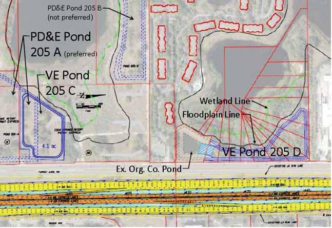
21 RECOMMENDATION No. 1: Use the FDOT property leased to OCCC for a pond to eliminate or minimize Pond 200B Proposed Alternative: The PD&E Documents show offsite Pond 200B on Parcel 80, at the beginning of Segment 2 and on the west side of I-4. VE Alternative: Reduce the size of Pond 200B by a third and provide the remainder of the needed stormwater storage in Pond 200D that is located within FDOT right-of-way in the northeast quadrant of the intersection of I-4 and SR 528. The land is currently being leased to the Orange County Convention Center and they are using it for parking. Advantages: The property for proposed Pond 200D is already owned by FDOT Less right of way cost Less overall cost Disadvantages: Construction of two ponds vs. one pond Long term maintenance of two ponds vs. one pond The property lease with Orange County would have to be terminated FHWA CATEGORIES Safety Operations Environment X Construction Other Potential Cost Savings: $1,800,000 PMA Consultants LLC 19
22 RECOMMENDATION No. 1: Use the FDOT property leased to OCCC for a pond to eliminate or minimize Pond 200B Calculations: Description Quantity Unit Unit Price Extended Amount Clearing and Grubbing 1.25 AC $ 7,724 $9,655 Excavation 65,674 CY $5.94 $390,104 Guardrail 1,500 LF $18.00 $27,000 Subtotal $426,759 Compensable Utility Relocation (5%) 1 LS $ 21,338 Mobilization (10%) 1 LS $ 42,676 Maintenance of Traffic (20%) 1 LS $ 85,352 Lighting (5%) 1 LS $ 21,338 Signage (5%) 1 LS $ 21,338 Drainage (20%) 1 LS $ 85,352 ITS (5%) 1 LS $ 21,338 Erosion Control (1%) 1 LS $ 4,268 Subtotal $729,757 Contingency (20%) LS $145,951 CONSTRUCTION TOTAL $875,709 Right-of-Way Cost Savings: $ 2.7 M Net Cost Savings: $1.8 M PMA Consultants LLC 20

23 RECOMMENDATION No. 1: Use the FDOT property leased to OCCC for a pond to eliminate or minimize Pond 200B PMA Consultants LLC 21
24 RECOMMENDATION No. 2: North of Yogi Bear Campground use the residential lots to wrap a pond around the existing lake and create a joint use pond with Orange County Proposed Alternative: The PD&E Documents show the preferred Pond 205A on assigned Parcel Numbers 81 and 82. Parcel 82 (formerly known as Yogi Bear Campground property) is located on the west side of Turkey Lake Road south of WalMart. VE Alternative: Construct a new Pond 205C on the Yogi Bear Campground property in conjunction with Pond 205D on the residential lots south of WalMart. Combine Pond 205D with the existing Orange County pond. An FDOT easement for an outfall into Big Sand Lake already exists. Advantages: Right of Way cost is less. FDOT and Orange County easements already in place to allow for discharge to the lake for combined Pond 205D. For Pond 205D a cross drain already exists across Turkey Lake Rd. A slight reduction in the size of Pond 205C can be achieved. Disadvantages: The right of way take involves more parcels. Additional coordination with Orange County for a joint use pond. Maintenance of two ponds vs. one Potential relocation issue FHWA CATEGORIES Safety Operations Environment Construction Other Potential Cost Savings: $2,100,000 PMA Consultants LLC 22
25 RECOMMENDATION No. 2: North of Yogi Bear Campground use the residential lots to wrap a pond around the existing lake and create a joint use pond with Orange County Calculations: Description Quantity Unit Unit Price Extended Amount Excavation 1,000 CY $5.94 $5,940 Clear and Grubbing 1 AC $7, $7,724 Fencing 1,000 LF $10.00 $10,000 $0 Subtotal $23,664 Compensable Utility Relocation (5%) 1 LS $ 1,183 Mobilization (10%) 1 LS $ 2,366 Maintenance of Traffic (20%) 1 LS $ 4,733 Lighting (5%) 1 LS $ 1,183 Signage (5%) 1 LS $ 1,183 Drainage (20%) 1 LS $ 4,733 ITS (5%) 1 LS $ 1,183 Erosion Control (1%) 1 LS $ 237 Subtotal $40,465 Contingency (10%) LS $8,093 CONSTRUCTION TOTAL $48,559 Right-of-Way Cost Savings: $2.1 M PMA Consultants LLC 23
26 RECOMMENDATION No. 2: North of Yogi Bear Campground use the residential lots to wrap a pond around the existing lake and create a joint use pond with Orange County PMA Consultants LLC 24
27 PMA Consultants LLC 25
28 RECOMMENDATION No. 3: North of Yogi Bear Campground use the residential lots to wrap a pond around the existing lake as a stand-alone pond Proposed Alternative: The PD&E Documents show preferred pond is Pond 205A on assigned Parcel Number 81 and 82. Parcel 82 (formerly known as Yogi Bear Campground property) located on the west side of the road south of WalMart. VE Alternative: Construct a new Pond 205C on the Yogi Bear Campground property in conjunction with Pond 205D on the residential lots south of WalMart. Construct stand-alone Pond 205D. An FDOT easement for an outfall into Big Sand Lake already exists. Advantages: Right of way cost is less. An FDOT easement is already in place to allow for discharge to the lake for Pond 205D. For Pond 205D a cross drain already exists across Turkey Lake Rd. Disadvantages: The right of way take involves more parcels. Maintenance of two ponds vs. one Potential relocation issue FHWA CATEGORIES Safety Operations Environment Construction Other Potential Cost Savings: $2,100,000 PMA Consultants LLC 26
29 RECOMMENDATION No. 3: North of Yogi Bear Campground use the residential lots to wrap a pond around the existing lake as a stand-alone pond Calculations: Description Quantity Unit Unit Price Extended Amount Excavation 1,000 CY $5.94 $5,940 Clear and Grubbing 1 AC $7, $7,724 Fencing 1,000 LF $10.00 $10,000 Subtotal $23,664 Compensable Utility Relocation (5%) 1 LS $ 1,183 Mobilization (10%) 1 LS $ 2,366 Maintenance of Traffic (20%) 1 LS $ 4,733 Lighting (5%) 1 LS $ 1,183 Signage (5%) 1 LS $ 1,183 Drainage (20%) 1 LS $ 4,733 ITS (5%) 1 LS $ 1,183 Erosion Control (1%) 1 LS $ 237 Subtotal $40,465 Contingency (10%) LS $8,093 CONSTRUCTION TOTAL $48,559 Right-of-Way Cost Savings: $ 2.1 M PMA Consultants LLC 27

30 RECOMMENDATION No. 3: North of Yogi Bear Campground use the residential lots to wrap a pond around the existing lake as a stand-alone pond PMA Consultants LLC 28
31 RECOMMENDATION No. 5: Avoid the east side right of way impacts by using Alternate 4 footprint at SR 528 Proposed Alternative: The PD&E Documents shows for the SR 528 interchange Alternate 1, proposed right of way takes from five parcels located on the east side of I-4 and proposed right of way takes from four parcels located on the west side of I-4. VE Alternative: This recommendation is to realign the horizontal geometry of the SR 528 interchange pushing the overall footprint westward to eliminate all right of way takes on the east side of I-4 as shown in the SR 528 interchange Alternate 4 exhibit. Advantages: Reducing the number of parcel impacts from 9 parcels to 4 parcels, which will result in reduced administration and legal costs. Improved public acceptance of project because eliminating right of way takes to properties on east side of I-4 will avoid the loss of over 130 parking spaces and the disruption of the parking lot circulation design for three of these properties. These property owners will be more in favor of the project with no impacts. Avoids a structural modification to the roof of the Orange County Sheriff Community Center. Although this recommendation is estimated to have a potential cost increase, it should be pursued because there are other parcels for sale along Turkey Lake road which may be less costly than the Pond 200-A parcel which was evaluated to be a total take for this study in order to provide a cure for the US Post Office right of way impacts. Disadvantages: Increased risk of not obtaining right of way take from the US Post Office parcel located on the west side of I-4 due to the additional right of way take that would be required with this recommendation. Estimated increased Turkey Lake Road construction cost by additional amount of $138,557. Increase in right of way take areas from the 4 parcels on the west side of I-4 will result in estimated additional right of way costs of $1.0 million, which includes the cost for a complete cure and possible relocation of the US Post Office on the west side of Turkey Lake Road FHWA CATEGORIES Safety Operations Environment X Construction Other Potential Value Added: ($1,139,000) PMA Consultants LLC 29
32 RECOMMENDATION No. 5: Avoid the east side right of way impacts by using Alternate 4 footprint at SR 528 Calculations: Description Quantity Unit Unit Price Extended Amount Embankment 2,000 CY $5.94 $11,880 Clearing & grubbing 5 AC $7, $38,620 Stabilization Type B LBR SY $2.90 $1,450 Base Optional (base group 6) 500 SY $13.69 $6,845 Superpave asphalt (Traffic B) 100 TN $87.28 $8,728 Subtotal $67,523 Compensable Utility Relocation (5%) 1 LS $ 3,376 Mobilization (10%) 1 LS $ 6,752 Maintenance of Traffic (20%) 1 LS $ 13,505 Lighting (5%) 1 LS $ 3,376 Signage (5%) 1 LS $ 3,376 Drainage (20%) 1 LS $ 13,505 ITS (5%) 1 LS $ 3,376 Erosion Control (1%) 1 LS $ 675 Subtotal $115,464 Contingency (10%) LS $23,093 CONSTRUCTION TOTAL $138,557 Estimated Right of Way Cost Increase $1,000,000 Cost of Work $ 138,557 Total Value Added $1,138,557 PMA Consultants LLC 30

33 RECOMMENDATION No. 5: Avoid the east side right of way impacts by using Alternate 4 footprint at SR 528 ALTERNATIVE 1 FOOTPRINT (SR 528) PMA Consultants LLC 31

34 RECOMMENDATION No. 5: Avoid the east side right of way impacts by using Alternate 4 footprint at SR 528 ALTERNATIVE 4 FOOTPRINT (SR 528) PMA Consultants LLC 32
35 RECOMMENDATION No. 8: Consider Single-Point Urban Interchange at SR 482 (Sand Lake Road) Proposed Alternative: The PD&E Documents show two alternatives. The first alternative is a combination diamond/partial clover-leaf interchange. The second alternative is a diverging-diamond interchange (DDI). VE Alternative: A third alternative, consisting of a single-point urban interchange, should be considered. The VE team recommends constructing a single-point urban interchange (SPUI). This concept will reduce the number of signalized ramp intersections from two to one and will improve operations of the system and is more user friendly for pedestrians and bikes through the corridor. Advantages: Combine two signalized intersections into one signalized intersection. Reduces the number of un-signalized pedestrian crossings. More flexibility in signal phasing. Compared to DDI, higher operating speed on SR 482 (i.e., improved capacity). Improved access management (potential for U-turns on SR 482). Disadvantages: Increased cost (i.e., ramp re-construction, longer bridge span) 500+ westbound right turn movements (per hour) on existing loop ramp are now left turn movements. (Important to note the eastbound Sand Lake Road left turn movements are 700+ vph (per January 2013 turning movement count). FHWA CATEGORIES X Safety X Operations Environment Construction Other Potential Value Added: ($7,000,000) (SPUI option comparable to DDI option) Additionally, further analysis should be performed by HDR to model the SPUI option and determine efficiency and other measure of effectiveness. PMA Consultants LLC 33
")
36 RECOMMENDATION No. 8: Consider Single-Point Urban Interchange at SR 482 (Sand Lake Road) PARTIAL CLOVERLEAF/DIAMOND INTERCHANGE PMA Consultants LLC 34
")
37 RECOMMENDATION No. 8: Consider Single-Point Urban Interchange at SR 482 (Sand Lake Road) DIVERGING DIAMOND INTERCHANGE PMA Consultants LLC 35

 Calculations: PMA")
38 RECOMMENDATION No. 8: Consider Single-Point Urban Interchange at SR 482 (Sand Lake Road) Calculations: PMA Consultants LLC 36
 SINGLE")
39 RECOMMENDATION No. 8: Consider Single-Point Urban Interchange at SR 482 (Sand Lake Road) SINGLE POINT URBAN INTERCHANGE (RECOMMENDED) PMA Consultants LLC 37
40 RECOMMENDATION No. 10: Eliminate the ramps to and from Central Florida Parkway Proposed Alternative: The PD&E Documents show a southbound off and northbound on ramp connecting the I-4 general use lanes to Central Florida Parkway. VE Alternative: Eliminate the ramps at this location. Advantages: Less capital cost Less right of way Reduction in future maintenance costs Less utility impacts Less maintenance of traffic concerns Improved constructability Disadvantages: Reduction in level of service Potential commitment that may exist FHWA CATEGORIES Safety Operations X Environment X Construction Other Potential Cost Savings: $49,400,000 PMA Consultants LLC 38
41 RECOMMENDATION No. 10: Eliminate the ramps to and from Central Florida Parkway Calculations: HNTB cost estimate for Compensable Utility Relocation from Sta to Sta is $4,305,514 Description Quantity Unit Unit Price Extended Amount Clearing & Grubbing -14 AC $7, ($108,136) Stabilization -45,467 SY $2.90 ($131,854) Base Optional (base group 6) -14,467 SY $13.69 ($198,053) Base Optional (base group 12) -25,420 SY $14.02 ($356,388) Superpave (Traff D-PG 76-22) -1,932 TN $89.64 ($173,211) Friction Course (FC-5) (PG 76-22) -1,438 TN $ ($168,522) Thermoplastic, White Striping -2 NM $3, ($5,596) Thermoplastic, Yellow Striping -2 NM $3, ($5,596) Embankment -57,867 CY $5.94 ($343,730) Bridges -36,200 SF $ ($5,792,000) Subtotal ($7,283,088) Compensable Utility Relocation (5%) 1 LS $ (364,154) Mobilization (10%) 1 LS $ (728,309) Maintenance of Traffic (20%) 1 LS $ (1,456,618) Lighting (5%) 1 LS $ (364,154) Signage (5%) 1 LS $ (364,154) Drainage (20%) 1 LS $ (1,456,618) ITS (5%) 1 LS $ (364,154) Erosion Control (1%) 1 LS $ (72,831) Subtotal ($12,454,081) Contingency (10%) LS ($2,490,816) CONSTRUCTION TOTAL ($14,944,897) Right of Way savings = $30,100,000 Construction savings = $14,944,897 Utilities savings = $ 4,305,514 TOTAL $49,350,411 PMA Consultants LLC 39

42 RECOMMENDATION No. 10: Eliminate the ramps to and from Central Florida Parkway PMA Consultants LLC 40
43 RECOMMENDATION No. 11: Combine ramps similar to SR 528 Alternate 2 Proposed Alternative: Alternative 1 is the baseline Alternative used by the VE team. The two mainline typical sections show that the majority of the roadway will be contained within the existing right of way (300 ft. minimum) with exception of the pond sites. The total length of bridges is 7,397 ft. with Construction Cost of $169,335,848. Wetland impact is 4.27 acres {data taken from PER dated January 30, 2014 Table 20}. Alternative 1 proposes several separate connector ramps with different elevations as follows: I-4 eastbound Express Lane to SR 528 eastbound I-4 eastbound General Use Lanes (GUL) to SR 528 eastbound SR 528 westbound to I-4 westbound Express Lane SR 528 westbound to I-4 westbound GUL I-4 westbound Express Lane to SR 528 eastbound I-4 westbound GUL to SR 528 eastbound SR 528 westbound to I-4 eastbound Express Lane SR 528 westbound to I-4 eastbound GUL Ponds: PONDS 202A & 202B & 202C & 202D and 201 Back & Front of Maintenance Berm Area is acres VE Alternative: Construct combined ramps at the interchange as in the configuration shown in SR 528 Alternative 2 as follows: I-4 eastbound (GUL & Express Lane) to SR 528 eastbound I-4 westbound (GUL & Express Lane) to SR 528 eastbound SR 528 westbound to I-4 westbound (GUL & Express Lane) SR 528 westbound to I-4 eastbound (GUL & Express Lane) The total length of bridges is 4,893 ft. with construction cost of $154,317,632. Wetland impact is 4.27 Acres. Ponds: 202A & 202C & 202D and 201 Back and front of maintenance berm area is acres Advantages: Less Construction Cost {$154 M vs. $169 M} Less Tiers of Bridges - Vertical Elevations 4 to 3-level Less MOT Less maintenance Shorter construction time Disadvantages: None apparent PMA Consultants LLC 41
44 RECOMMENDATION No. 11: Combine ramps similar to Alternate 2 FHWA CATEGORIES Safety X Operations X Environment X Construction Other Potential Cost Savings: $15,782,000 Calculations: Embankment -1 CY $189, ($189,642) MSE Wall -1 SF $1,003, ($1,003,998) Barrier Wall -1 CY $3,924, ($3,924,893) Stabilization Type B LBR 40-1 SY $10, ($10,621) Base Group 12-1 SY $973, ($973,776) Superpave Traffic Level D PG TN $58, ($58,829) Superpave Traffic Level D -1 TN $85, ($85,852) Asphalt Friction FC-5 PG TN $28, ($28,843) Bridges -1 SF $1,414, ($1,414,464) Subtotal ($7,690,918) Compensable Utility Relocation (5%) 1 LS $ (384,546) Mobilization (10%) 1 LS $ (769,092) Maintenance of Traffic (20%) 1 LS $ (1,538,184) Lighting (5%) 1 LS $ (384,546) Signage (5%) 1 LS $ (384,546) Drainage (20%) 1 LS $ (1,538,184) ITS (5%) 1 LS $ (384,546) Erosion Control (1%) 1 LS $ (76,909) Subtotal ($13,151,470) Contingency (15%) LS ($2,630,294) CONSTRUCTION TOTAL ($15,781,764) PMA Consultants LLC 42

45 RECOMMENDATION No. 11: Combine ramps similar to Alternate 2 ALTERNATIVE 1 PMA Consultants LLC 43

46 RECOMMENDATION No. 11: Combine ramps similar to Alternate 2 ALTERNATIVE 2 (RECOMMENDED) PMA Consultants LLC 44
47 APPENDICES Agenda Sign In Sheets Presentation Slides PMA Consultants LLC 45
48 Agenda February 10 14, 2014 Day One Kickoff Intro by VE Team Leader 8:00 am 8:15 am Team Review and Discussions of Documents Designer Orientation Questions for Designers Travel to Site Lunch Site Review Return to Lake Mary Summarize Site Review & Constraints 8:15 am 9:30 am 9:30 am 10:00 am 10:00 am 11:00 am 11:00 am 12:00 pm 12:00 pm 1:00 pm 1:00 pm 3:30 pm 3:30 pm 4:30 pm 4:30 pm 5:00 pm Day Two Cost Model & Function Analysis 8:00 am 9:00 am FAST Diagram Intro to Creative Thinking Creative Idea Listing/Function Lunch Creative/Evaluation/Function 9:00 am 9:30 am 10:00 am 10:15 am 10:15 am 12:00 pm 12:00 pm 1:00 pm 1:00 pm 5:00 pm Day Three Evaluation Phase 8:00 am 9:00 am Mid-point review and determine economic factors Begin Development Phase Lunch Continue Development 9:00 am 10:00 am 10:00 am 12:00 pm 12:00 pm 1:00 pm 1:00 pm 5:00 pm Day Four Continue Development 8:00 am 5:00 pm Day Five Finish Development/Prepare Oral Presentation 8:00 am 11:00 am Oral Presentation to FDOT/others Begin Draft Value Engineering Report 11:00 am 12:00 pm 12:00 pm 5:00 pm PMA Consultants LLC 46
49 PMA Consultants LLC 47
50 PMA Consultants LLC 48
51 PMA Consultants LLC 49
52 PMA Consultants LLC 50
53 PMA Consultants LLC 51
Conclusions & Lessons Learned
 What is a DDI Recommended Practices Traffic Operations Analysis Geometric Design FHWA Review Conclusions & Lessons Learned It s not about you, it s about the public Developed by Access Utah County
WELCOME IL 47. Community Advisory Group Meeting #5 Waubonsee Community College Wednesday, May 31, 2017
 WELCOME IL 47 Community Advisory Group Meeting #5 Waubonsee Community College Wednesday, May 31, 2017 MEETING PURPOSE MEETING AGENDA 1. Welcome/Introduction 2. Review Previous Public Involvement 3. Process/Schedule
The Folded Interchange: An Unconventional Design for the Reconstruction of Cloverleaf Interchanges
 The Folded Interchange: An Unconventional Design for the Reconstruction of Cloverleaf Interchanges I. ABSTRACT Keith A. Riniker, PE, PTOE This paper presents the Folded Interchange design and compares
SR 417 Extension. June 2003 INTRODUCTION AND HISTORY PROJECT SCOPE AND PURPOSE STUDY OBJECTIVE STUDY PHASES
 Planning Feasibility Study June 2003 INTRODUCTION AND HISTORY The SR 417 Extension Study was a yearlong effort undertaken by Florida s Turnpike Enterprise to investigate the feasibility of a new toll road
NW La Center Road/I-5 Interchange Improvement Project (MP 16.80)
") FINAL DRAFT - NW La Center Road/I-5 Interchange Improvement Project (MP 16.80) La Center, Washington February 2015 FINAL DRAFT - NW La Center Road/I-5 Interchange Improvement Project (MP 16.80) La Center,
FINAL DRAFT - NW La Center Road/I-5 Interchange Improvement Project (MP 16.80) La Center, Washington February 2015 FINAL DRAFT - NW La Center Road/I-5 Interchange Improvement Project (MP 16.80) La Center,
FLORIDA DEPARTMENT OF TRANSPORTATION Planning and Environmental Management Office INTERCHANGE MODIFICATION REPORT
 FLORIDA DEPARTMENT OF TRANSPORTATION Planning and Environmental Management Office INTERCHANGE MODIFICATION REPORT District 2 1109 South Marion Avenue Lake City, FL 32025-5874 INTERSTATE 10 (SR 8) / SR
Interchange Workshop Report (August 2004)
") U.S. Highway 14 Corridor Study New Ulm to North Mankato Table of Contents Section Interchange Workshop Report (August 2004) Page 1. Introduction and Next Steps 1 2. Interchange Workshop Participants &
U.S. Highway 14 Corridor Study New Ulm to North Mankato Table of Contents Section Interchange Workshop Report (August 2004) Page 1. Introduction and Next Steps 1 2. Interchange Workshop Participants &
SR 9/I-95 Interchange at 45th Street PD&E Study Palm Beach County, Florida FPID No.: FAP No.: ETDM No.
 Palm Beach County, Florida Palm Beach Metropolitan Planning Organization April 217 Project Study Area LIMITS: SR 9/I-95: from S of 45th Street to N of 45th Street 45th Street: From Village Boulevard to
2 Purpose and Need. 2.1 Study Area. I-81 Corridor Improvement Study Tier 1 Draft Environmental Impact Statement
 2 Purpose and Need 2.1 Study Area Interstate 81 (I-81) is relied upon for local and regional travel and interstate travel in the eastern United States. It extends 855 miles from Tennessee to New York at
LAFAYETTE RAILROAD RELOCATION, NORFOLK SOUTHERN CORRIDOR
 LAFAYETTE RAILROAD RELOCATION, NORFOLK SOUTHERN CORRIDOR July 12, 2002 A Paper Submitted for the AREMA Annual Conference by: Paul B. Satterly, P.E. HNTB CORPORATION 111 Monument Circle, Suite 1200 Indianapolis,
CHAPTER 4 GRADE SEPARATIONS AND INTERCHANGES
 CHAPTER 4 GRADE SEPARATIONS AND INTERCHANGES 4.0 INTRODUCTION The ability to accommodate high volumes of intersecting traffic safely and efficiently through the arrangement of one or more interconnecting
HIGHLANDS COUNTY BOARD OF COUNTY COMMISSIONERS Tuesday, February 20, :30 PM 600 S. Commerce Ave. Sebring, FL AGENDA
 HIGHLANDS COUNTY BOARD OF COUNTY COMMISSIONERS Tuesday, February 20, 2018 5:30 PM 600 S. Commerce Ave. Sebring, FL 33870 AGENDA 1 MEETING CALLED TO ORDER: Invitation to fill out "citizens not on the agenda
August 15, 2006 (Revised) July 3, 2006 Project No A
 July 3, 2006 Project No A") August 15, 2006 (Revised) July 3, 2006 Project No. 01-05-0854-101A Mr. David Reed, P.E. Protean Design Group 100 East Pine Street, Suite 306 Orlando, Florida 32801 Preliminary Soil Survey Report Polk Parkway
August 15, 2006 (Revised) July 3, 2006 Project No. 01-05-0854-101A Mr. David Reed, P.E. Protean Design Group 100 East Pine Street, Suite 306 Orlando, Florida 32801 Preliminary Soil Survey Report Polk Parkway
EXISTING ROADWAY CONDITION ASSESSMENT REPORT (ERCAR) SAMPLE OUTLINE
 SAMPLE OUTLINE") EXISTING ROADWAY CONDITION ASSESSMENT REPORT (ERCAR) SAMPLE OUTLINE The Existing Roadway Condition Assessment Report (ERCAR) should include the evaluation of all elements against new construction criteria.
EXISTING ROADWAY CONDITION ASSESSMENT REPORT (ERCAR) SAMPLE OUTLINE The Existing Roadway Condition Assessment Report (ERCAR) should include the evaluation of all elements against new construction criteria.
Table of Contents. I-4 Express Lanes Concept of Operations
 Table of Contents 1 Overview... 5 1.1 Purpose of the Concept of Operations... 5 1.2 Scope... 5 1.3 Background... 5 1.4 Operational Needs... 7 2 Referenced Documentation... 9 3 Existing Conditions... 10
I-15 South, MP 0 to MP 16 Environmental Assessment. Public Hearing. August 7, :00 PM to 7:00 PM
 I-15 South, MP 0 to MP 16 Environmental Assessment Public Hearing August 7, 2012 5:00 PM to 7:00 PM 1 PROJECT OVERVIEW The Federal Highway Administration (FHWA) and the Utah Department of Transportation
LOCATION AND DESIGN DIVISION
 VIRGINIA DEPARTMENT OF TRANSPORTATION LOCATION AND DESIGN DIVISION INSTRUCTIONAL AND INFORMATIONAL MEMORANDUM GENERAL SUBJECT: Design Exceptions / Waivers SPECIFIC SUBJECT: Design Exception Request Form
Appendix D: Functional Classification Criteria and Characteristics, and MnDOT Access Guidance
 APPENDICES Appendix D: Functional Classification Criteria and Characteristics, and MnDOT Access Guidance D.1 Functional classification identifies the role a highway or street plays in the transportation
MDX Contract #: RFP MDX Work Program #: ETDM #: 11501
 SR 874/Don Shula Expressway Ramp Connector Project Development & Environment (PD&E) Study PUBLIC HEARING December 8, 2011 MDX Contract #: RFP-09-04 MDX Work Program #: 87410.011 ETDM #: 11501 1 This Public
500 Interchange Design
 500 Interchange Design Table of Contents 501 Interchange Design... 5-1 July 2015 501.1 General... 5-1 501.2 Interchange Type... 5-1 501.2.1 General... 5-1 502 Interchange Design Considerations... 5-2 502.1
MAINE TRANSPORTATION BY THE NUMBERS:
 MAINE TRANSPORTATION BY THE NUMBERS: Meeting the State s Need for Safe and Efficient Mobility OCTOBER 2012 202-466-6706 www.tripnet.org Founded in 1971, TRIP of Washington, DC, is a nonprofit organization
IOWA TRANSPORTATION BY THE NUMBERS:
 IOWA TRANSPORTATION BY THE NUMBERS: Meeting the State s Need for Safe and Efficient Mobility MARCH 2013 202-466-6706 www.tripnet.org Founded in 1971, TRIP of Washington, DC, is a nonprofit organization
Hampton Roads Bridge-Tunnel Expansion Feasibility Study. Design Considerations
 Hampton Roads Bridge-Tunnel Expansion Feasibility Study Tunnels Design Considerations The proposed location for the new tunnel crossing is about 250 feet away from the existing westbound tunnel. This matches
Project Team. D6 South Miami-Dade Resident Engineer Erik Padron, P.E. D6 Construction Project Manager Dari Vorce
 Project Team D6 South Miami-Dade Resident Engineer Erik Padron, P.E. D6 Construction Project Manager Dari Vorce D6 Design Project Manager Ali Toghiani, P.E. CEI: AIM Engineering and Surveying Francis Chin,
Concept, Feasibility & Mobility Studies. Southport Connector Expressway
 Concept, Feasibility & Mobility Studies Southport Connector Expressway Project Background FDOT Alternative Corridor Evaluation (ACE) Study Advanced Notification Package distributed September 2012 ETDM
GEOMETRIC DESIGN CRITERIA for Non-freeway Resurfacing, Restoration, and Rehabilitation Projects
 GEOMETRIC DESIGN CRITERIA for Non-freeway Resurfacing, Restoration, and Rehabilitation Projects SEPTEMBER 1989 Arkansas State Highway and Transportation Department GEOMETRIC DESIGN CRITERIA for Non-freeway
2017 Highway Safety Improvement Program Call
 2017 Highway Safety Improvement Program Call The Highway Safety Improvement Program (HSIP) is for highway safety projects that eliminate or reduce the number of fatalities and serious injuries on all public
APPENDIX F: CALTRANS COST ESTIMATE TEMPLATE (included in Appendix AA of the CALTRANS Project Development Procedures Manual)
") APPENDIX F: CALTRANS COST ESTIMATE TEMPLATE (included in Appendix AA of the CALTRANS Project Development Procedures Manual) PROJECT DESCRIPTION: (Enter Type of Project Planning Cost Estimate as Title)
APPENDIX F: CALTRANS COST ESTIMATE TEMPLATE (included in Appendix AA of the CALTRANS Project Development Procedures Manual) PROJECT DESCRIPTION: (Enter Type of Project Planning Cost Estimate as Title)
Interstate 66 Widening from. RFQ Information Meeting. January 4, 2012 Christiana Briganti-Dunn, P.E. District Project Manager
 Interstate 66 Widening from Gainesville to Haymarket RFQ Information Meeting January 4, 2012 Christiana Briganti-Dunn, P.E. District Project Manager John C. Daoulas, P.E. APD Project Manager and POC Introduction
Project Alignment Appendix A
 Project Alignment Appendix A Fargo Moorhead Metropolitan Area Flood Risk Management Project EA Document This page is intentionally left blank Project Alignment Appendix A Table of Contents 1 BACKGROUND...
Appendix B Highway 407 Interchange Review - Cochrane Street Area
 Appendix B Highway 407 Interchange Review - Cochrane Street Area AECOM 300 ater Street hitby, ON, Canada L1N 9J2 www.aecom.com Memorandum To Michael May, P.Eng., Town of hitby Page 1 CC Subject Greg Hardy,
Appendix B. Benefit-Cost Technical Memorandum
 Appendix B Benefit-Cost Technical Memorandum This Page Left Blank Intentionally MEMORANDUM TO: FROM: Michael Kalnbach MnDOT District 1 Project Manager Graham Johnson, PE DATE: September 2, 2014 RE: TH
Members of the Board of Directors. Laurena Weinert, Clerk of the Board
 COMMITTEE TRANSMITTAL July, 06 To: From: Subject: Members of the Board of Directors Laurena Weinert, Clerk of the Board Update on the State Route Improvement Project Between Interstate 0 and Interstate
APPROVAL TO SUBMIT COMMENTS ON I-45 AND MORE DRAFT ENVIRONMENTAL IMPACT STATEMENT
 TAC Agenda Item 09 Mailout 7/12/17 APPROVAL TO SUBMIT COMMENTS ON I-45 AND MORE DRAFT ENVIRONMENTAL IMPACT STATEMENT Background The Texas Department of Transportation, in cooperation with the Federal Highway
ADOT Yuma District. Alvin Stump, P.E. ADOT Yuma District Engineer Rural Transportation Summit January 20, 2012
 ADOT Yuma District Alvin Stump, P.E. ADOT Yuma District Engineer Rural Transportation Summit January 20, 2012 Active Construction Projects SR 95@ Bill Williams River NWR Rd CAP Intersection US 95, Castle
DEVELOPMENT, ANALYSIS, AND DESIGN OF A NEW PARKWAY AT GRADE INTERSECTION (PAGI)
") 2013 ITE Western District Annual Meeting COCEPT DEVELOPMET, AALYSIS, AD DESIG OF A EW PARKWAY AT GRADE ITERSECTIO (PAGI) Lead Author: James M. Witkowski, PhD Supporting Author: Darrell Truitt, PE The Pima
2013 ITE Western District Annual Meeting COCEPT DEVELOPMET, AALYSIS, AD DESIG OF A EW PARKWAY AT GRADE ITERSECTIO (PAGI) Lead Author: James M. Witkowski, PhD Supporting Author: Darrell Truitt, PE The Pima
Central Phoenix Transportation Framework Study
 Central Phoenix Transportation Framework Study Study Area 2013, All Rights Reserved. 1 Agenda Introductions Work Products Feedback on previous products Draft products for Planning Partner review SR-30
SR 29 Project Development & Environment Study. Presentation to SR 29 Stakeholders Advisory Committee. January 23, 2014
 SR 29 Project Development & Environment Study Presentation to SR 29 Stakeholders Advisory Committee January 23, 2014 Purpose and Need Enhancing Economic Competitiveness Improving Emergency Evacuation Capabilities
Problem Screening Guideline January, 2016
 Problem Screening Guideline January, 2016 Check the Capital Project Delivery website to ensure this is the current version Table of Contents Purpose... 1 Introduction... 1 The following are the major work
POND SITING REPORT TABLE OF CONTENTS LIST OF TABLES LIST OF FIGURES EXECUTIVE SUMMARY SECTION 1.0 INTRODUCTION SECTION 2.0 PROJECT DESCRIPTION
 November, 2014 TABLE OF CONTENTS LIST OF TABLES LIST OF FIGURES EXECUTIVE SUMMARY POND SITING REPORT Summary of section 1.0 & 2.0. Specify datum used in the design calculations and the construction plans.
ALTERNATIVE PROJECT DELIVERY DIVISION
 VIRGINIA DEPARTMENT OF TRANSPORTATION ALTERNATIVE PROJECT DELIVERY DIVISION INSTRUCTIONAL AND INFORMATIONAL MEMORANDUM GENERAL SUBJECT: Design-Build Requirements for Advertisement SPECIFIC SUBJECT: APPROVED:
Working with Transportation Concurrency Exception Areas
 Working with Transportation Concurrency Exception Areas September 2006 Presented by the Florida Department of Transportation Working with Transportation Concurrency Exception Areas Volume 1, September
THE PROJECT. Executive Summary. City of Industry. City of Diamond Bar. 57/60 Confluence.
 THE PROJECT A freeway segment ranked 6th worst in the Nation, with levels of congestion, pollution and accidents that are simply unacceptable and which have Statewide and National implications. Executive
Statewide Acceleration Transformation (SWAT)
") Presented to: AASHTO SCOE/SCOD Presented by: Marjorie Kirby Paul Hiers, P.E. Statewide Acceleration Transformation (SWAT) July 2017 PD&E Study Comply with the National Environmental Policy Act (NEPA) and
Presented to: AASHTO SCOE/SCOD Presented by: Marjorie Kirby Paul Hiers, P.E. Statewide Acceleration Transformation (SWAT) July 2017 PD&E Study Comply with the National Environmental Policy Act (NEPA) and
Enterprise Parkway Improvement Project, CIP# E364
 Exhibit A SCOPE OF SERVICES AND FEES This project, in general, consists of: Construction of roadway improvements to extend Enterprise Parkway east of Superior Industries and Lockheed Martin to connect
1RUWKZHVW#:LFKLWD 0DMRU#,QYHVWPHQW#6WXG\
 1RUWKZHVW#:LFKLWD 0DMRU#,QYHVWPHQW#6WXG\ Executive Summary 3UHSDUHGýIRUã 3UHSDUHGýE\ã.DQVDVý'HSDUWPHQWýRI 7UDQVSRUWDWLRQ,QýDVVRFLDWLRQýZLWKã (DUWKý7HFKý,QFï EXECUTIVE SUMMARY Introduction This Northwest
TECHNICAL MEMORANDUM
 California High-Speed Train Project TECHNICAL MEMORANDUM 15% Design Scope Guidelines TM 0.1 Signed document on file Prepared by: 12 May 08_ Ken Jong, PE Checked by: Signed document on file 12 May 08_ John
APPENDIX B. Public Works and Development Engineering Services Division Guidelines for Traffic Impact Studies
 APPENDIX B Public Works and Development Engineering Services Division Guidelines for Traffic Impact Studies Revised December 7, 2010 via Resolution # 100991 Reformatted March 18, 2011 TABLE OF CONTENTS
Cost Estimating Guideline February, 2017
 Cost Estimating Guideline February, 2017 Procedures are subject to change without notice. Check the Capital Project Delivery website to ensure this is the current version. Table of Contents Section 1 -
Design-Build. Authorization. Criteria Selection/Award Process. Design-Build Construction Engineering and Inspection
 DESIGN-BUILD Design-Build Authorization Project Selection Criteria Selection/Award Process Warranties Design-Build Construction Engineering and Inspection Materials Acceptance DESIGN-BUILD AUTHORIZATION
TRANSPORTATION IMPACT STUDIES
 January 28, 2009 POLICIES AND PROCEDURES FOR TRANSPORTATION IMPACT STUDIES Related to Highway Occupancy Permits Pennsylvania Department of Transportation Bureau of Highway Safety and Traffic Engineering
CHAPTER 2B - PHASE I, INITIAL ROADWAY INVESTIGATION & PRELIMINARY FIELD INSPECTION
 CHAPTER 2B - PHASE I, INITIAL ROADWAY INVESTIGATION & PRELIMINARY FIELD INSPECTION SECTION 2B 1 - GROUND SURVEYS Survey Authorization... 2B-1 Interstate... 2B-1 Principal / Minor Arterial... 2B-1 Urban...
3 PROJECT DESCRIPTION
 3.1 PROJECT OVERVIEW 3 PROJECT DESCRIPTION The Rocklin 60 project (proposed project) includes the subdivision of 56.9 acres of land, construction of 179 single-family, detached dwelling units, and installation
Safety. Introduction. Total System
 Safety Introduction Ohio is the 35 th largest state in the nation based on geographic size, however it carries the 5 th largest total traffic volume and the 4 th largest truck traffic volume. With such
Performance Based Practical Design (PBPD)
") Performance Based Practical Design (PBPD) 2016 ODOT D08 LPA Day John R. Kasich, Ohio Governor Jerry Wray, ODOT Director PBPD PBPD Presenter Katherine DeStefano, P. E. District 08 Design Engineer ODOT D08
Performance Based Practical Design (PBPD) 2016 ODOT D08 LPA Day John R. Kasich, Ohio Governor Jerry Wray, ODOT Director PBPD PBPD Presenter Katherine DeStefano, P. E. District 08 Design Engineer ODOT D08
THE COMMONWEALTH OF MASSACHUSETTS NON-NHS BRIDGE R&R POLICY
 THE COMMONWEALTH OF MASSACHUSETTS Number: P-92-010 Date: 10-08-92 - ) HIGHWAY DEPARTMENT FROM: NON-NHS BRIDGE R&R POLICY The purpose of this Engineering Directive is to formally notify Department Personnel
Slide 1. A Free sample background from
 Slide 1 Slide 2 Office of Access Design Slide 3 * TOPICS * Office of Access Design Scheduled Activities Definitions Being Being Customer Friendly Designer s s Requirements Access Access Appeal Process
Overall project. The $288 million Phase 2 DesignBuild project starts construction. this spring, with completion by December 31, 2016
 Overall project Johnson County Gateway Interchange Project Improvements 87th Street The $288 million Phase 2 DesignBuild project starts construction this spring, with completion by December 31, 2016 Phase
UNIVERSITY OF OREGON NORTH CAMPUS CONDITIONAL USE PERMIT PROJECT Draft Conditional Use Permit Stormwater, Sanitary Sewer, and Water Analysis Report
 UNIVERSITY OF OREGON NORTH CAMPUS CONDITIONAL USE PERMIT PROJECT Draft Conditional Use Permit Stormwater, Sanitary Sewer, and Water Analysis Report Prepared for: Cameron McCarthy Landscape Architects LLP
State Route 8 Bridge Replacement Project
 OPEN HOUSE PUBLIC INVOLVEMENT MEETING Celebration Church 688 Dan Street, Akron, Ohio Tuesday, July 14, 2015 5:00 PM to 7:00 PM State Route 8 Bridge Replacement Project Existing Bridge Future Bridges: Steel
I-35W Retaining Wall Design Exhibit A - Draft Scope of Work
 Background MnDOT, Metro Transit, Hennepin County, and the City of Minneapolis are in the process of developing a project for Interstate 35W between 43 rd Street in Minneapolis and 15 th Street in Minneapolis.
SP Old Florida Investment Resources, LLC SMR Aggregates SR 64 Borrow Pit (DTS # )
") H.O. 03/24/14 SP-14-01 Old Florida Investment Resources, LLC SMR Aggregates SR 64 Borrow Pit (DTS #201400001) Request: Approval of a Special Permit for major earthmoving in the A (General Agriculture)
H.O. 03/24/14 SP-14-01 Old Florida Investment Resources, LLC SMR Aggregates SR 64 Borrow Pit (DTS #201400001) Request: Approval of a Special Permit for major earthmoving in the A (General Agriculture)
CITY OF CLOVIS Traffic Impact Study Guidelines
 CITY OF CLOVIS Traffic Impact Study Guidelines CLOVIS, A WAY OF LIFE Approved August 25, 2014 City Council Resolution 2014-79 Prepared by City of Clovis Engineering Division Steve White, City Engineer
LOUISIANA TRANSPORTATION BY THE NUMBERS:
 LOUISIANA TRANSPORTATION BY THE NUMBERS: Meeting the State s Need for Safe, Smooth and Efficient Mobility MARCH 2017 202-466-6706 tripnet.org Founded in 1971, TRIP of Washington, DC, is a nonprofit organization
Scope of Work. Project Approach and Understanding. Task 1: Study Initiation and Administration
 Scope of Work Route 116/Hinesburg Growth Center Corridor Study Town of Hinesburg and CCRPC Project Approach and Understanding Route 116 through Hinesburg had seen substantial changes in the past 15 years,
SH 35 Public Meeting
 SH 35 Public Meeting Major Corridor Feasibility Study Environmental Impact Statement March 27 and 28, 2007 Good evening and welcome to the State Highway 35 Public Meeting. This meeting is being conducted
APPLICATION FOR PUBLIC INFRASTRUCTURE PERMIT
 APPLICATION FOR PUBLIC INFRASTRUCTURE PERMIT Engineering Division 550 Landa Street New Braunfels, Texas 78130 (830) 221-4020 1. Subdivision Plat Name: Location Description/ Nearest Intersection: Acreage:
Railyard Enterprise Project (REP) Supplemental Scoping
 Supplemental Scoping") FINAL SCOPE OF WORK DATE: November 11, 2016 PROJECT: PROJECT DESCRIPTION Railyard Enterprise Project (REP) Supplemental Scoping The City of Burlington and VTrans would like to further evaluate the REP
FINAL SCOPE OF WORK DATE: November 11, 2016 PROJECT: PROJECT DESCRIPTION Railyard Enterprise Project (REP) Supplemental Scoping The City of Burlington and VTrans would like to further evaluate the REP
NOISE STUDY REPORT DESIGN ADDENDUM
 NOISE STUDY REPORT DESIGN ADDENDUM for Wekiva Parkway Segment 8 - Ballantrae Apartments Seminole County, Florida Financial Project ID: 240200-4-32-01 Prepared for: Florida Department of Transportation
APPENDIX A TIER 1 ANALYSIS
 SPN H.004100 FEASIBILITY STUDY APPENDIX A TIER 1 ANALYSIS 040-012-042AH Appendices Lead Sheets PROVIDENCE STATE PROJECT. H.004100 The following worksheets analyze various project alternatives at various
APPENDIX C INLETS. The application and types of storm drainage inlets are presented in detail in this Appendix.
 Storm Drainage 13-C-1 APPENDIX C INLETS 1.0 Introduction The application and types of storm drainage inlets are presented in detail in this Appendix. 2.0 Inlet Locations Inlets are required at locations
INTERSTATE CORRIDOR PLANNING
 INTERSTATE CORRIDOR PLANNING Prioritization of Corridor Studies July 29, 2015 Importance of the Interstate System Texas is an integral part of the national interstate system. The interstate system provides
I-10 Master Plan Escambia and Santa Rosa Counties TPO Meetings. Tier II June 11 th & 13 th, 2012
 I-10 Master Plan Escambia and Santa Rosa Counties TPO Meetings Tier II June 11 th & 13 th, 2012 Agenda Introduction & Background Study Area Purpose & Need Project Status Tier Methodology & Tier I Evaluation
Qualitative Hot Spot Analysis for PM2.5 February 4, 2008
 Technical Guidance for TG-POL-01-08 Qualitative Hot Spot Analysis for PM2.5 February 4, 2008 This technical guidance provides general guidelines for performance of a qualitative hot spot analysis for particulate
Mr. Michael Malone CPS Energy 145 Navarro Street San Antonio, Texas Project No
 Environmental Resources Management January 13, 2017 Mr. Michael Malone 145 Navarro Street San Antonio, Texas 78205 Project No. 0352436 CityCentre Four 840 West Sam Houston Parkway North, Suite 600 Houston,
STATE AID GUIDE FOR: Updated: December 16, 2005
 STATE AID GUIDE FOR: Updated: December 16, 2005 1. AFTER THE FACT RIGHT OF WAY DEPARTMENT OF MINNESOTA TRANSPORTATION 2. MISCELLANEOUS AFTER THE FACT Traffic Signals, Lighting, Retaining Walls, Sidewalk,
FY STATEWIDE TRANSPORTATION IMPROVEMENT PROGRAM New Jersey Department of Transportation Project Descriptions ($ millions)
") FY 2018-2027 WIDE TRANSPORTATION IMPROVEMENT PROGRAM NY Susquehanna and Western Rail Line Bicycle/Pedestrian Path DBNUM: NS9803 / UPC: 058018 The 4.8 mile New York, Susquehanna, and Western Railway (NYS&W)
FY 2018-2027 WIDE TRANSPORTATION IMPROVEMENT PROGRAM NY Susquehanna and Western Rail Line Bicycle/Pedestrian Path DBNUM: NS9803 / UPC: 058018 The 4.8 mile New York, Susquehanna, and Western Railway (NYS&W)
For Public Input Period
 20142018 CAPITAL IMPROVEMENT PLAN ( Thousands) CITY OF HOUSTON STREET & TRAFFIC CONTROL Project: Kingwood Drive N100011 Loop 494 to Woodland Hills Project Description Project provides for the ROW acquisition,
Draft Noise Study Report
 Florida Department of TRANSPORTATION PD&E Study From East of Babcock Street (SR 507) to US 1 Brevard County, Florida FPID: 430136 1 22 01 ETDM: 13026 The environmental review, consultation, and other actions
California High-Speed Train Program FEIR/EIS
 Page 2-30 Page 2-31 Page 2-32 Page 2-33 Page 2-34 Page 2-35 Page 2-36 of Enrique Manzanilla, Director U.S. Environmental Protection Agency, August 31, 2004 (Letter AF008) AF008-1 Acknowledged. AF008-2
CONNECTICUT TRANSPORTATION BY THE NUMBERS:
 CONNECTICUT TRANSPORTATION BY THE NUMBERS: Meeting the State s Need for Safe and Efficient Mobility MAY 2017 202-466-6706 tripnet.org Founded in 1971, TRIP of Washington, DC, is a nonprofit organization
PROJECT CHARTER South Coast 101 HOV Lanes Project Design Decision Phase
 PROJECT CHARTER South Coast 101 HOV Lanes Project Design Decision Phase PRIMARY PROJECT SPONSOR Santa Barbara County Association of Governments (SBCAG) Date Prepared 03 April 2015 PROJECT PARTNERS Santa
SUBDIVISION SECTION STREET DESIGN MANUAL
 CITY OF ANAHEIM SUBDIVISION SECTION STREET DESIGN MANUAL A. INTRODUCTION : POLICY STATEMENT B. STREET CLASSIFICATION C. STREET STANDARDS REQUIREMENTS Requirements Approval of Street Improvement Plans Widening
The New Highway Capacity Manual 6 th Edition It s Not Your Father s HCM
 The New Highway Capacity Manual 6 th Edition It s Not Your Father s HCM Tom Creasey, PE, PhD Principal, Stantec Consulting Services Inc. Chair, TRB Highway Capacity and Quality of Service Committee Presented
Memorandum. 921 SW Washington Street, Suite 468, Portland, OR tel fax
 Date: September 16, 2010 To: I-84/US 395 IAMP Project Team From: Shayna Rehberg, AICP Darci Rudzinski, AICP Re: I-84/US 395 Interchange Area Management Plan Proposed IAMP Policies and Code Amendments L
Exclusive Facilities for Trucks in Florida: An Investigation of the Potential for Reserved Truck Lanes and Truckways on the State Highway System
 Exclusive Facilities for Trucks in Florida: An Investigation of the Potential for Reserved Truck Lanes and Truckways on the State Highway System Stephen L. Reich, Janet L. Davis, Anthony J. Ferraro, and
ORLANDO INTERNATIONAL AIRPORT (OIA) CONNECTOR REFRESH ALTERNATIVES ANALYSIS FINAL REPORT
 CONNECTOR REFRESH ALTERNATIVES ANALYSIS FINAL REPORT") ORLANDO INTERNATIONAL AIRPORT (OIA) CONNECTOR REFRESH ALTERNATIVES ANALYSIS FINAL REPORT Prepared For: Florida Department of Transportation, District Five Prepared By: HDR Engineering, Inc. February 2016
ORLANDO INTERNATIONAL AIRPORT (OIA) CONNECTOR REFRESH ALTERNATIVES ANALYSIS FINAL REPORT Prepared For: Florida Department of Transportation, District Five Prepared By: HDR Engineering, Inc. February 2016
CONTRACT No.: E8M79 Date: 06/30/14 Page 1 of 5
 Page 1 of 5 FLORIDA S TURNPIKE ENTERPRISE (FTE) Construction Engineer: Pete Nissen, P.E. Assistant Construction Engineer: Bill Sears, P.E. FDOT Design William Sloup, P.E. GEC Design Terry Miller, P.E.
Chapter 7. Street Drainage. 7.0 Introduction. 7.1 Function of Streets in the Drainage System. 7.2 Street Classification
 7. Introduction This chapter summarizes methods to evaluate runoff conveyance in various street cross sections and curb types in the Town of Castle Rock and identifies acceptable upper limits of street
GUARDRAIL WARRANTS FOR LOW VOLUME ROADS
 74 GUARDRAIL WARRANTS FOR LOW VOLUME ROADS Louis B. Stephens, P.E. INTRODUCTION Low volume roads present many challenges to highway engineers and public administrators. Although, by definition, these facilities
PROJECT SCOPING PHASE ~ SCOPE OF SERVICES MAIN STREET BRIDGE OVER WINOOSKI RIVER CITIES OF BURLINGTON & WINOOSKI VERMONT
 PROJECT SCOPING PHASE ~ SCOPE OF SERVICES MAIN STREET BRIDGE OVER WINOOSKI RIVER CITIES OF BURLINGTON & WINOOSKI VERMONT PROJECT DESCRIPTION McFarland-Johnson, Inc. (MJ) has prepared this proposal to perform
LOCATION AND DESIGN DIVISION
 VIRGINIA DEPARTMENT OF TRANSPORTATION LOCATION AND DESIGN DIVISION INSTRUCTIONAL AND INFORMATIONAL MEMORANDUM GENERAL SUBJECT: Interstate, NHS Non-Interstate and Non-NHS (IJR / IMR Guidance) SPECIFIC SUBJECT:
CITY OF ASTORIA PUBLIC WORKS ENGINEERING DIVISION ENGINEERING DESIGN STANDARDS FOR IN-FILL DEVELOPMENT
 CITY OF ASTORIA PUBLIC WORKS ENGINEERING DIVISION ENGINEERING DESIGN STANDARDS FOR IN-FILL DEVELOPMENT Adopted by City Council: May 21, 2007 X:\General Eng\DESIGN STANDARDS\Engineering Design Standards
Appendix D - Evaluation of Interim Solutions
 Appendix D - Evaluation of Interim Solutions D.1 Introduction The implementation of long-term improvements is projected to take 5 to 8 years. To reduce the number of years of flooding impacts, the partner
summary report West Texas Rail Feasibility Study Texas Department of Transportation Cambridge Systematics, Inc. HNTB August 2011
 summary report prepared for Texas Department of Transportation prepared by Cambridge Systematics, Inc. with HNTB August 2011 www.camsys.com summary report West Texas Rail Feasibility Study prepared for
PLAN 2040 Regional Transportation Plan Update. Final Recommendations. Transportation and Air Quality Committee March 13, 2014
 PLAN 2040 Regional Transportation Plan Update Final Recommendations Transportation and Air Quality Committee March 13, 2014 TIP/RTP Update Milestones Official public comment period closed February 21 Final
Grade-Separated Trail Crossings How Do We Get Over There?
 Grade-Separated Trail Crossings How Do We Get Over There? 2008 National Trails Symposium Rory Renfro, Alta Planning + Design Scott Belonger, Loris and Associates Peter Loris, Loris and Associates PRESENTATION
Chapter 2: Alternatives
 Chapter 2: Alternatives Introduction An Environmental Impact Statement (EIS) is a procedural document. In other words, the environmental planning process follows a logical sequence of development. Subsequent
FEDERAL BOULEVARD (5 TH AVENUE TO HOWARD PLACE) PLANNING ENVIRONMENTAL LINKAGE STUDY TRAFFIC NOISE IMPACT ANALYSIS
 PLANNING ENVIRONMENTAL LINKAGE STUDY TRAFFIC NOISE IMPACT ANALYSIS") FEDERAL BOULEVARD (5 TH AVENUE TO HOWARD PLACE) PLANNING ENVIRONMENTAL LINKAGE STUDY TRAFFIC NOISE IMPACT ANALYSIS Prepared for: City and County of Denver 201 West Colfax Avenue, Department 509 Denver,
FEDERAL BOULEVARD (5 TH AVENUE TO HOWARD PLACE) PLANNING ENVIRONMENTAL LINKAGE STUDY TRAFFIC NOISE IMPACT ANALYSIS Prepared for: City and County of Denver 201 West Colfax Avenue, Department 509 Denver,
SCOPE OF SERVICES INTERSTATE 195 CORRIDOR PLANNING STUDY FROM INTERSTATE 95/NW 12 TH AVENUE TO ALTON ROAD
 SCOPE OF SERVICES INTERSTATE 195 CORRIDOR PLANNING STUDY FROM INTERSTATE 95/NW 12 TH AVENUE TO ALTON ROAD (ROADWAY ID 87004000 - MP 0.000 TO MP 4.910) (ROADWAY ID 87003000 MP 3.962 TO MP 4.132) BACKGROUND