ESA s Earth Observation Programmes - Activities related to GEWEX
|
|
|
- Ashlie Reeves
- 6 years ago
- Views:
Transcription

1 ESA s Earth Observation Programmes - Activities related to GEWEX GEWEX SSG March 2017 Sanya, China Michael Rast ESA-ESRIN

2 Changing Meteo Copernicus Science


3 Meteorological Missions ESA develops prototype satellites and, on behalf of EUMETSAT, procures recurrent satellites EUMETSAT operates the satellites Currently Meteosat Second Generation (MSG) in GEO and MetOp in LEO in orbit Meteosat Third Generation (MTG) and MetOp Second Generation under development, launch in next decade MetOp MSG MTG MetOp SG


4 Copernicus: A New Generation of Data Sources Sent-1A/B Sent-2A/B Sent-3A/B Sent-4A/B Sent-5/5P Sent-6A/B Copernicus - European space flagship programme, led by the EU ESA is responsible for space component, Sentinel development, operation of some Sentinels, data buy from other partners, system evolution Sentinels most comprehensive EO system world-wide for environmental monitoring Free and open data policy


5 What is Copernicus? European response to global needs: to manage the environment, to mitigate the effects of climate change and to ensure civil security In- Situ Data a Space Component Services Component

6 Copernicus: Earthquake Italy 30 Oct 2016

7 Rome seen by Sentinels

8 Earth Explorers launched so far

9 Swarm: Wandering Magnetic North
 mitigation continues Outstanding international")
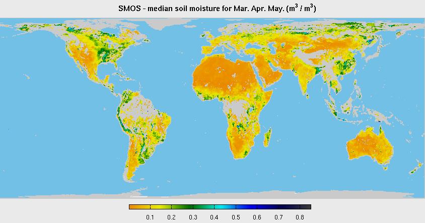
10 SMOS Surface Moisture and Ocean Salinity Data delivery since February 2010 Complete Earth coverage within three days Radio Frequency Interference (RFI) mitigation continues Outstanding international cooperation


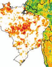


11 SMOS: Monitoring 5 droughts in 2015 India Oct CA, USA Sept Brazil May 2015 Root zone soil moisture (m 3 /m 3 ) SouthAfrica April 2015 Australia June 2015 Drought index moderate mild A.Al-Bitar, CESBIO

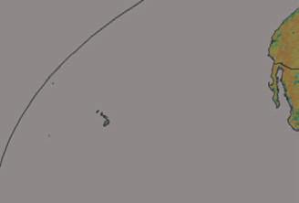
12 SMOS and Storms Control experiment Track and intensity of Hurricane Marie, Aug 2014, according to Saffir-Simpson hurricane wind scale SMOS intercepts Assimilating SMOS Best track SMOS intercepting Hurricane Marie

.")


, LMAA (LTHE)")

13 Enhancing Rainfall estimates bottom-up On-going research and development continues to address the accuracy and the resolution (temporal and spatial) of rainfall products (Kidd and Levizzani, 2011). Rainfall signals from soil moisture observations may help to enhance existing rainfall products (example below shows the soil moisture signal of a rainfall event captured by SMOS and not by a LSM based on CMORPH) SMOS The project will further advance three existing methods; SEN2RAIN (IRPI, IT), LMAA (LTHE) and SMART (USGS); Develop and validate new products at global scale with error and uncertainties characterisation. LSM using CMORPH

14 Enhancing Rainfall estimates bottom-up

 play a big role) Can we characterize a DSSS-RR relationship at short time")
![scale (~30mn)? SMOS DSSS & RemSS RR [-15mn; +30mn] Pacific ITCZ 2012 year. Slope ~-0.](/docs-images/78/78252589/images/15-2.jpg "2pss/ mm/h Satellite rainfall (SSMIs) and SMOS freshenings (DSSS = SSS-SSSref) are")
15 Enhancing Rainfall estimates over the Ocean To which extent can we use SSS as a rain gauge? No direct relationship between monthly RR and monthly SSS freshening (other processes (e.g. advection) play a big role) Can we characterize a DSSS-RR relationship at short time scale (~30mn)? SMOS DSSS & RemSS RR [-15mn; +30mn] Pacific ITCZ 2012 year. Slope ~-0.2pss/ mm/h Satellite rainfall (SSMIs) and SMOS freshenings (DSSS = SSS-SSSref) are closely correlated (Boutin et al. 2013, 2014) at local scale and short temporal scale (<30mn)


16 Cryosat the Ice Mission First interferometric altimeter in space Global sea ice thickness measurements Data used for ice research, but increasingly also for oceanography


17 CryoSat SAR for Inland Waters Previous satellite radar altimeters lost significant amounts of information due to onboard echo averaging. The high along-track sampling of Cryosat-2 altimeter in SAR mode offers the opportunity to recover high frequency signals over much of the Earth s land surface. Six months of SAR (red) and LRM (green) tracks over the Amazon Basin 3.5 month of SAR L1B data categorized using waveform shape with water echoes selected using a river mask. Shape identification gives geographic distribution of water-waveforms and complex echo shapes with water components. Brightest echoes often complex shapes, multi-target responses. Combination of simple quasi-specular returns and complex multi-target echoes (more numerous than from previous altimeters) allows to enhance waveform parameterisation in order to improve height calculation.


18 WACMOS-ET: Intercomparison of Global ET WACMOS-ET was a contribution to GEWEX LandFlux to cross-compare main global ET products: PM-Mu, PT-JPL, GLEAM and SEBS. Comparison was based on a reprocessing of algorithms based on a reference input dataset. Mean seasonal differences. Average evaporation for PM-Mu, GLEAM and PT-JPL during boreal summer (June, July and August) and austral summer (December, January and February). The ERA-Interim reanalysis and MTE are considered for comparison. The three years of data ( ) are used in the calculation of these seasonal averages
 against tower reference, as function of biomes, sorted from wet to dry (based on the biome average).")
19 WACMOS-ET: Intercomparison of Global ET Station means of 3-hourly Evaporative fraction derived from Eddy Covariance-observed and estimated with tower-forced (top panel) and satellite-forced (bottom panel) against tower reference, as function of biomes, sorted from wet to dry (based on the biome average). The grey area denotes the range of evaporative fraction (grey area) between Eddy Covariance and Energy Residual tower measurements. The black line denotes EF derived from ERA-Interim ET and Rn.

20 WACMOS: Intercomparison of Global ET products Contribution to GEWEX Land-Flux As a reference a BEST product was created by choosing the closes estimate (GLEAM or PT) to the tower observation. Figure plots the difference between product correlation and BEST product correlation. At 41/62 stations weighted R > average R for true weights method, 36/62 for predicted weights, but again very small differences. In overall the merging approach enhance single products except for a number of towers. An experiment with a larger datset of tower data needed.


21 WACMOS-MED: A new collaboration with HYMEX ESA-HYMEX WACMOS-Med: Is a new collaboration with the Mediterranean regional project of GEWEX (HYMEX) aimed at: Assess the quality of current EO-based products to characterise the water cycle over the Med area; Develop a new consistent datasets of the ocean, land and atmosphere products that closes the water budget over the Mediterranean area; Perform a water cycle budget closure experiment assessing the variability and trends of the Mediterranean water cycle based on EO; Implement an integrated approach exploiting the budget closure condition as a constrain to merge the existing different datasets; The project will also: Study the impact of climate variability on the Mediterranean water cycle; Enhance current estimates of river discharge; Study the links of the water cycle and Oceanic circulation; Explore potential improvements to Flash-floods predictions;


 in Mediterranean region viewed from Earth")
22 Advancing Science: Water Cycle in the Mediterranean Basins considered in the analysis Integration approach will consider ocean, atmosphere and land components Water cycle seasonality depicted through its various water components (in rows) over the various sub-basins (in columns) in Mediterranean region viewed from Earth Observation and reanalysis
 and evapo(transpi)ration (bottom panel) using a simple weighting (SW)")

23 WACMOS-MED: Water Cycle in the Mediterranean Monthly mean patterns for: precipitation (top panel) and evapo(transpi)ration (bottom panel) using a simple weighting (SW) integration approach (first row of each panel) and ERA-I (second row). From top to bottom, monthly mean patterns for: discharge, water storage, water vapor and moisture divergence in SW.


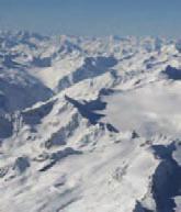

24 Mountains under Mittelbergferner Glacier Antarctica Antarctica
: Developing")


, SANSA (South")


 research")

25 TIGER Capacity Building Facility (TCBF): Developing African Knowledge and Scientific Capacity Training Activities: Dedicated Training courses in Africa & Europe Empowerment of Regional Centres: AGHRYMET (Niger), RCMRD (Kenya), SANSA (South Africa); OSS (Tunisia) Partnership with UNDP Cap-Net for Training of Trainers Water Research Component Support to 70 & 20 (current) research projects in Africa TIGER Research Fellowships TIGER workshop 2013, Tunisia TIGER workshop 2011, South Africa


26 To us TIGER is the precursor for GMES & Africa, particular if we look a water resource management Mahama Ouedraogo, African Unio African EO Water Community 100 registered participants 19 African & 10 European countries 8 trans-boundary Basin authorities, 10 National water authorities, 9 Intergovernmental Organisations, 31 R&D institutions 7 th TIGER workshop since start of TIGER in 2002


27 African European research collaboration TIGER Research Projects & Fellowships International Research Studies Collaboration between African and European scientists TIGER Research Projects: Collaborative research between institutes open research calls TIGER Research Fellowships Ongoing: 10 Research projects on Water for Agriculture 1 year scientific visits of young African scientists European Research Institutes Objectives: Identify water research topics in Africa Develop innovative EO algorithms Transfer research into applications African Research Institutes

:")


 Water")


28 TIGER Capacity Building Facility (TCBF): Developing African Knowledge and Scientific Capacity TIGER Training Kit Data & Tools (WOIS) Water quality monitoring Flood mapping Vegetation & evapotranspiration Crop monitoring Land cover mapping


29 Water Observation Information System For African Water Authorities Objective: Enable African water authorities to improve IWRM by exploiting Earth Observation (EO) technology Implement an operational Water Observation Information System (WOIS) for monitoring water resources Developed in collaboration with African water authorities Transboundary Observation Capacity Transparent tool for Reporting & IWRM Sustainability through Open Source & CB Enabling the Use of Earth Observation Data for Integrated Water Resource Management in Africa with the Water Observation and Information System Radoslaw Guzinski et al., Remote Sens. 2014, 6(8), ; doi: /rs


30 Support for Monitoring & Reporting LAKE CHAD BASIN CHARACTERIZATION The WOIS will allow us to assess environmental variables by catchment over the whole basin for the 1 st State of the Lake Chad Basin Report Mohammed Bila, Head of the Lake Chad Basin Observatory, LCBC WOIS integrated information: hydrological network Land cover, seasonal and long-term map of changes Drought condition and water stress anomaly other operational EO products (precipitation, etc.) Monitoring/Reporting/Management/Intervention


31 Hydro-TEP: WOIS in the cloud Dealing with large data volume Collaborative & open platform for large data volume processing & sharing for IWRM Hydrological modeling, flood mapping, small water bodies mapping, water quality & water level Supports algorithm development, sharing of data, tools & knowhow


32 SDG 6.6 & 15.1: Freshwater Ecosystem GLOBWETLAND AFRICA IN A NUTSHELL Exploit increasing capabilities of satellite observations for wetlands inventory, assessment and monitoring Develop EO methods and tools to better assess conditions of wetlands and monitor trends over time Enhance capacity of African stakeholders to develop national and regional wetland observatories Access ì freely availableî satellite data from the Sentinel missions of the European Copernicus initiative


33 SDG 6.6 Water & Wetland Extent Sudd wetland, South Sudan SENTINEL-1 image data Soil Moisture Wetland extension Contains modified Copernicus Sentinel data [2015]


34 Partnerships for Implementation Sustainable Development Initiative EO informing Development activities & investments planning, design, implementation & monitoring Collaboration with International Development Banks Earth observation is key to the sustainable development goals, Laura Tuck, World Bank Vice President for Sustainable Development


35 TIGER s Footprint in Africa A contribution to AfriGEOSS : 119 Training participants Training Participants Workshop Participants Research Activities 90 projects & 9 Fellows WOIS Application 4 Transboundary & 4 National Water Authorities i e id i P e rrr i P d P i P i i i r r n n r t t t np P i r r


36 Thematic Exploitation Platform (TEP) for Hydrology A heterogeneous community of scientific users, river basin organisations and service providers aiming to exchange data, services and knowledge through a common collaboration framework. SMHI hydrology-tep.eo.esa.int Community Platform An open, collaborative and inclusive community where users can SHARE information, knowledge, algorithms, methods, tools, results, products, services Service Platform A portal providing LARGE SCALE EO SERVICES & PRODUCTS customised for hydrology applications. Flood monitoring and small Water bodies mapping, Water quality and level, Hydrological models Enhancing Platform A workspace based on the Cloud where users can discover, access, PROCESS, UPLOAD, visualise, manipulate and compare data

37


38 ADM-Aeolus Global observations of wind profiles for analysis of global 3D wind field Launch planned for end 2017 EarthCARE Upcoming Earth Explorers Global observations of clouds, aerosols and radiation Launch planned for 2019


39 Further Earth Explorer Missions 7 th Earth Explorer: Biomass Biomass estimates based on global interferometric and polarimetric P-Band Radar observations 8 th Earth Explorer: FLEX global maps of vegetation fluorescence, which can be converted into an indicator of photosynthetic activity
40 Improvement of European involvement in GEWEX How can ESA intensify its contribution to GEWEX? How can ESA and GEWEX cooperate to implement the 2016 Workshop Scientific Agenda (eo4water)? Shall we promote a new initiative on the Water Cycle in the Ocean? +?
ESA Programmes Earth Observation Navigation
 05 March 2007 SSOM Engelberg Lectures R. Hartmann / Eumetsat, Meteosat-8, 28-Jun-2004, VIS+IR ESA Programmes Earth Observation Navigation Urs Frei Swiss Space Office (SSO) SSOM Engelberg Lectures, 05 March
Climate observations and services: GCOS and GFCS
 WMO World Meteorological Organization Working together in weather, climate and water Climate observations and services: GCOS and GFCS Sophia Sandström Climate and Water Department World Meteorological
LAND AND WATER - EARTH OBSERVATION INFORMATICS FSP
 Earth Observation for Water Resources Management Arnold Dekker,Juan P Guerschman, Randall Donohue, Tom Van Niel, Luigi Renzullo,, Tim Malthus, Tim McVicar and Albert Van Dijk LAND AND WATER - EARTH OBSERVATION
Global Water Initiative Team Project
 Global Water Initiative Team Project International Space University International, Intercultural, interdisciplinary (3Is) since 1987 UNCOPUOS Scientific and Technical Subcommittee 3 February 2015 GLOBAL
Issues include coverage gaps, delays, measurement continuity and consistency, data format and QC, political restrictions
 Satellite-based Estimates of Groundwater Depletion, Ph.D. Chief, Hydrological Sciences Laboratory NASA Goddard Space Flight Center Greenbelt, MD Groundwater Monitoring Inadequacy of Surface Observations
Hydrological Feedbacks in Tropical African Wetlands
 Hydrological Feedbacks in Tropical African Wetlands Simon Dadson University of Oxford (simon.dadson@ouce.ox.ac.uk) Key challenges Linking across scales: can we predict the hydrological response to climate
Copernicus and Downstream Industry
 Copernicus and Downstream Industry Powered by INSPIRE Conference 5 March, 2013 Bussels Daniel Quintart Legal Officer 1 Outline Copernicus an introduction Specific service applications Access to in situ
Chief, Hydrological Sciences Laboratory NASA Goddard Space Flight Center
 Detection of Extreme Events with GRACE and Data Assimilation, Ph.D. Chief, Hydrological Sciences Laboratory NASA Goddard Space Flight Center Gravity Recovery and Climate Experiment (GRACE) Soil Moisture
WMO s Expectations on Application of Satellite Information in Hydrology and Water Resources
 WMO World Meteorological Organization weather, climate and water WMO s Expectations on Application of Satellite Information in Hydrology and Water Resources Julius Wellens-Mensah E-Mail: jwellens-mensah@wmo.int
Activity Update Rick Lawford. Richard Lawford GWSP SSC Xian, China October 19,2011
 Activity Update Rick Lawford Richard Lawford GWSP SSC Xian, China October 19,2011 GEO related activities By 2015, produce comprehensive sets of data, information products and services to support decision-making
Use of Earth Observation Data for Water Resources Management by the Nile Basin Initiative. - Tigernet Project
 Use of Earth Observation Data for Water Resources Management by the Nile Basin Initiative. - Tigernet Project By Milly Mbuliro GIS/ Remote Sensing Specialist Nile Basin Initiative Secretariat 25-27 March,
NASA s Contribution to Water Research, Applications, and Capacity Building in Africa
 NASA s Contribution to Water Research, Applications, and Capacity Building in Africa Nancy D. Searby 1, David Toll 2, Rick Lawford 3, 1 NASA HQ Earth Sciences Division Applied Sciences Program 2 NASA GSFC
Summary of the socio-economic impact of Copernicus in the EU
 Summary of the socio-economic impact of Copernicus in the EU ESA Since the entry into service of Copernicus first satellite, Sentinel-1A, in 2014, the impacts of the programme are witnessed beyond the
Copernicus Climate Change Service (C3S)
") Copernicus Service (C3S) European Contribution to the Monitoring of Essential Variables from Space Jean-Noël Thépaut, ECMWF C o p e r n i c u s : E a r t h o b s e r v a t i o n s a n d i n f o r m a t
Copernicus Service (C3S) European Contribution to the Monitoring of Essential Variables from Space Jean-Noël Thépaut, ECMWF C o p e r n i c u s : E a r t h o b s e r v a t i o n s a n d i n f o r m a t
Operational products for crop monitoring. Hervé Kerdiles, JRC MARS
 Operational products for crop monitoring Hervé Kerdiles, JRC MARS Outline Meteo products Rainfall, temperature, global radiation, ETa, snow depth Biomass indicators & crop yield prediction NDVI & other
EU-Africa collaboration on Space applications for Africa
 EU-Africa collaboration on Space applications for Africa Background Maputo Declaration: African policy makers request EC to open its GMES initiative to Africa (Oct 2006) Build on existing EO activities
Diego Fernández Prieto European Space Agency
 Diego Fernández Prieto European Space Agency Diego.Fernandez@esa.int Background In 2006, ESA has published The Changing Earth, which represents the main new driver for the ESA EO Science Strategy. The
Date: Author: Doc Title. 20/08/14 Jimmy Slaughter Copernicus Services. Copernicus Services
 Date: Author: Doc Title 20/08/14 Jimmy Slaughter Copernicus Services Copernicus Services Table of Contents Introduction... 3 What Will Copernicus Do?... 3 2.1 Land Monitoring... 3 2.2 Marine Monitoring...
Key elements of the GMES EC Draft Action Plan Initial Period
 Brussels, 27/07/2001 Key elements of the GMES EC Draft Action Plan Initial Period 2001-2003 For information: Michel.Cornaert@cec.eu.int Hugo.De_Groof@cec.eu.int Neil.Hubbard@jrc.it Errol.Levy@cec.eu.int
ENSC425/625 Climate Change and Global Warming
 ENSC425/625 Climate Change and Global Warming 1 Emission scenarios of greenhouse gases Projections of climate change Regional climate change (North America) Observed Changes and their Uncertainty 2 Figure
GEOGLAM international cooperation activities
 GEOGLAM international cooperation activities Chris Justice Center for Global Agricultural Monitoring and Research Dept. of Geographical Sciences University of Maryland GEO: an International Coordinating
The Biomass mission How it works, what it measures? Thuy Le Toan, CESBIO, Toulouse, France & The Biomass Mission Advisory Group
 The Biomass mission How it works, what it measures? Thuy Le Toan, CESBIO, Toulouse, France & The Biomass Mission Advisory Group Why Synthetic Aperture Radars to observe the world forests? Transmit and
NASA International Water Activities Towards Water Security
 National Aeronautics & NASA International Water Activities Towards Water Security David Toll Hydrological Sciences NASA/GSFC NASA Water Resources Support Bradley Doorn NASA Manager Nancy Searby NASA Capacity
Remote sensing: A suitable technology for crop insurance?
 Remote sensing: A suitable technology for crop insurance? Geospatial World Forum 2014 May 9, 2014, Geneva, Switzerland Agenda 1. Challenges using RS technology in crop insurance 2. Initial situation Dominance
UCS#4: Soil moisture assessment over Africa
 UCS#4: Soil moisture assessment over Africa S. Horion, H. Nieto*, T. Tagesson, R. Fensholt * Institute for Sustainable Agriculture CSIC, Córdoba, Spain Rationale and objectives Accurate estimates of soil
Land surface albedo and downwelling shortwave radiation from MSG: Retrieval, validation and impact assessment in NWP and LSM models
 Land surface albedo and downwelling shortwave radiation from MSG: Retrieval, validation and impact assessment in NWP and LSM models Jean-Louis ROUJEAN, Dominique CARRER, Xavier CEAMANOS, Olivier HAUTECOEUR,
SENSOR PERFORMANCES, PRODUCT AND ALGORITHM THE EVOLUTION OF QUALITY ASSURANCE TOWARD GMES
 SENSOR PERFORMANCES, PRODUCT AND ALGORITHM THE EVOLUTION OF QUALITY ASSURANCE TOWARD GMES Lecomte Pascal European Space Agency, Via Galileo Galilei, 00044 Frascati, Italy, pascal.lecomte@esa.int ABSTRACT
BUILDING EXPOSURE MAPS OF URBAN INFRASTRUCTURE AND CROP FIELDS IN THE MEKONG RIVER BASIN
 BUILDING EXPOSURE MAPS OF URBAN INFRASTRUCTURE AND CROP FIELDS IN THE MEKONG RIVER BASIN E. Haas (1), J. Weichselbaum (1), U. Gangkofner (1), J. Militzer (1), A. Walli (1) (1) GeoVille, Sparkassenplatz
Mrs NOASILALAONOMENJANAHARY A. Lucie GEO- DSWG Member National Focal Point AfriGEOSS - Madagascar
 Mrs NOASILALAONOMENJANAHARY A. Lucie GEO- DSWG Member National Focal Point AfriGEOSS - Madagascar GEO plenary side event DSWG and DMP TF 12 November 2014 14h00 17h30 PLAN AfriGEOSS in General (Background,
Michel F. Massart DG ENTR - European Commission
 Michel F. Massart DG ENTR - European Commission COPERNICUS Program COPERNICUS Global Land component COPERNICUS Program Copernicus seen from the Regulation (GMES) Global Monitoring for Environment and Security
Intersection of SAR imagery with medium resolution DEM for the estimation of regional water storage changes
 Intersection of SAR imagery with medium resolution DEM for the estimation of regional water storage changes Sonya Spiridonova 1, Karin Hedman 1, Florian Seitz 2 1 Earth Oriented Space Science and Technology
II. CLIMATE CHANGE AND ADAPTATION
 II. CLIMATE CHANGE AND ADAPTATION Human beings have been adapting to the variable climate around them for centuries. Worldwide local climate variability can influence peoples decisions with consequences
Suborbital Measurement Program Using the MEOS Spectrometer (MEOSuB)
") Suborbital Measurement Program Using the MEOS Spectrometer (MEOSuB) J.J. Sloan, R. V. Kruzelecky, K. Strong and J. Lin Workshop on Suborbital Platforms and Nanosatellites Canadian Space Agency, Saint-Hubert,
Suborbital Measurement Program Using the MEOS Spectrometer (MEOSuB) J.J. Sloan, R. V. Kruzelecky, K. Strong and J. Lin Workshop on Suborbital Platforms and Nanosatellites Canadian Space Agency, Saint-Hubert,
THE GLOBAL WATER CYCLE THEME WITHIN THE INTEGRATED GLOBAL OBSERVING STRATEGY FRAMEWORK
 THE GLOBAL WATER CYCLE THEME WITHIN THE INTEGRATED GLOBAL OBSERVING STRATEGY FRAMEWORK RICK LAWFORD & JOSEF ASCHBACHER WATER FOR THE WORLD: SPACE SOLUTIONS FOR WATER MANAGEMENT SEPTEMBER 13, 2004 GRAZ,
Update on the Water Cycle Community of Practice
 Update on the Water Cycle Community of Practice Rick Lawford November 2009 UIC Meeting Washington DC Community of Practice involves a number of individuals with an enthusiasm for a specific topic. In the
Seasonal Variation of Total Terrestrial Water Storage in Major River Basins
 http://hydro.iis.u-tokyo.ac.jp/ 1 Seasonal Variation of Total Terrestrial Water Storage in Major River Basins T Oki, P. Yeh, K Yoshimura, H Kim, Y Shen, N D Thanh, S Seto, and S Kanae Institute of Industrial
Takashi Moriyama & Han Dolman On behalf of GEO Carbon CoP and GEO task CL and contributors
 User Engagement Session 1-2 November, China National Convention Center, Beijing Room 401 The GEO Carbon strategy Takashi Moriyama & Han Dolman On behalf of GEO Carbon CoP and GEO task CL-09-03 and contributors
Ch 18. Hydrologic Cycle and streams. Tom Bean
 Ch 18. Hydrologic Cycle and streams Tom Bean Wednesday s outline 1. the hydrologic cycle reservoirs cycling between them Evaporation and the atmosphere 2. Surface hydrology infiltration and soil moisture
Monitoring, Assessment, Prediction and Meteorological service of Agricultural Drought in China
 Monitoring, Assessment, Prediction and Meteorological service of Agricultural Drought in China Wang Shili China Meteorological Administration January, 2005, Kobe Content Characteristics of agrometerological
Surface Water and Ocean Topography (SWOT) Mission. Lake Vector Products Tamlin Pavelsky and Jean-Francois Cretaux
 Mission. Lake Vector Products Tamlin Pavelsky and Jean-Francois Cretaux") Surface Water and Ocean Topography (SWOT) Mission Lake Vector Products Tamlin Pavelsky and Jean-Francois Cretaux SWOT Science Definition Team Meeting, July 7-9, 2015 Proposed Vector Data Products Pass-based
Surface Water and Ocean Topography (SWOT) Mission Lake Vector Products Tamlin Pavelsky and Jean-Francois Cretaux SWOT Science Definition Team Meeting, July 7-9, 2015 Proposed Vector Data Products Pass-based
WATER AND THE HYDROLOGIC CYCLE
 WATER AND THE HYDROLOGIC CYCLE Summary Water is essential for the support of life and can be considered as a fundamental environmental good. Water is needed to support human habitation, grow crops and
 FP7- SPA.2013.1.1-06: Stimulating development of downstream services and service evolution. Contract N : 606983 A downstream service to support agro-production, planning and policy http://www.ermes-fp7space.eu/
1.6 Influence of Human Activities and Land use Changes on Hydrologic Cycle
 1.6 Influence of Human Activities and Land use Changes on Hydrologic Cycle Watersheds are subjected to many types of changes, major or minor, for various reasons. Some of these are natural changes and
SOLAR THERMAL ELECTRICITY GENERATION. By Franz Trieb, Carsten Hoyer, Stefan Kronshage, Richard Meyer, Marion Schroedter-Homscheidt
 SOLAR THERMAL ELECTRICITY GENERATION By Franz Trieb, Carsten Hoyer, Stefan Kronshage, Richard Meyer, Marion Schroedter-Homscheidt 28 Solar Potentials and Markets Power Solar irradiance is the fuel for
Hydrology and Water Management. Dr. Mujahid Khan, UET Peshawar
 Hydrology and Water Management Dr. Mujahid Khan, UET Peshawar Course Outline Hydrologic Cycle and its Processes Water Balance Approach Estimation and Analysis of Precipitation Data Infiltration and Runoff
Monitoring and Assessment of Drylands: Forests, Rangelands, Trees, and Agrosilvopastoral Systems
 Workshop on Monitoring and Assessment of Drylands: Forests, Rangelands, Trees, and Agrosilvopastoral Systems Combining local surveillance and spatial observation for environmental monitoring in the Circum-Sahara:
Stocktaking Overview of the G20. Global Agricultural Monitoring Initiative
 Stocktaking Overview of the G20 Global Agricultural Monitoring Initiative February 2018 Background The Group on Earth Observations Global Agricultural Monitoring Initiative (GEOGLAM) was initially launched
New vision for new. Water in the 21 st. challenges. century: Vision on water resources monitoring in. Vito Colloquium on. the 21 st century,
 Vito Colloquium on Vision on water resources monitoring in the 21 st century, Antwerpen, November 26, 2009 Water in the 21 st New vision for new century: challenges Global Crises Global water resources
User Awareness & Training: LAND. Tallinn, Estonia 9 th / 10 th April 2014 GAF AG
 User Awareness & Training: LAND Tallinn, Estonia 9 th / 10 th April 2014 GAF AG Day 2 - Contents LAND (1) General Introduction to EO and the COPERNICUS Sentinel Programme Overview of COPERNICUS/GMES LAND
The Water Cycle and Water Insecurity
 Edexcel Geography A-level The Water Cycle and Water Insecurity PMT Education Written by Jeevan Singh The Water Cycle and Water Insecurity Enquiry question 1: What are the processes operating within the
Module 5 Measurement and Processing of Meteorological Data
 Module 5 Measurement and Processing of Meteorological Data 5.1 Evaporation and Evapotranspiration 5.1.1 Measurement of Evaporation 5.1.2 Pan Evaporimeters 5.1.3 Processing of Pan Evaporation Data 5.1.4
What is the Copernicus Climate Change Service?
 What is the Copernicus Climate Service? Copernicus for Climate Adaptation and Mitigation Copernicus EU Copernicus EU Copernicus EU www.copernicus.eu INTRODUCTION The Copernicus Climate Service (C3S) has
Future remote sensors for chlorophyll a. Dimitry Van der Zande, Quinten Vanhellemont & Kevin Ruddick
 Future remote sensors for chlorophyll a Dimitry Van der Zande, Quinten Vanhellemont & Kevin Ruddick Workshop Scheldt Commission: eutrophication 20 th October 2016 Ocean colour from space ESA MERIS 7 May
MAPPING, MODELING AND MANAGING FLOOD RISKS
 MAPPING, MODELING AND MANAGING FLOOD RISKS Giriraj Amarnath International Water Management Institute (IWMI), Colombo, Sri Lanka JPTM for Sentinel Asia STEP3 (JPTM 2013), 27 28 Nov 2013, Bangkok, Thailand
GCOS and WCRP activities on inventories of climate datasets
 GCOS_new_logo.PNG CEOS-CGMS-WMO Architecture for Climate Monitoring Group, Geneva, 19 February 2013 GCOS and WCRP activities on inventories of climate datasets Adrian Simmons Chair, Steering Committee
Introduction. Welcome to the Belgium Study Abroad Program. Courses:
 Introduction Welcome to the Belgium Study Abroad Program Courses: AGSM 335: Soil and Water Management BAEN 460: Principals of Environmental Hydrology BAEN 460 / AGSM 335 Combined lecture and HW sessions
HS Hydrological Sciences (#EGU18HS) Orals Monday, 09 April
 Orals Monday, 09 April") HS Hydrological Sciences (#EGU18HS) Orals Monday, 09 April MO1, 08:30 10:00 HS1.4, Advances in Diagnostics, Sensitivity, and Uncertainty Analysis of Earth and Environmental Systems Models, 08:30 15:00,
HS Hydrological Sciences (#EGU18HS) Orals Monday, 09 April MO1, 08:30 10:00 HS1.4, Advances in Diagnostics, Sensitivity, and Uncertainty Analysis of Earth and Environmental Systems Models, 08:30 15:00,
Yiwen Mei. Summary. Experience. Research Assistant at University of Connecticut
 Yiwen Mei metaphysical@live.cn Summary I am interested in any hydro-meteorological related research, especially on the hydrologic potential on satellite-based dataset. I have experiences on the evaluation
The EUMETSAT Satellite Application Facility on Land Surface Analysis (LSA SAF) Continuous Development 2 Phase
 Continuous Development 2 Phase") The EUMETSAT Satellite Application Facility on Land Surface Analysis (LSA SAF) Continuous Development 2 Phase Jean-Louis Roujean and many co-authors METEO FRANCE / Toulouse jean-louis.roujean@meteo.fr
The EUMETSAT Satellite Application Facility on Land Surface Analysis (LSA SAF) Continuous Development 2 Phase Jean-Louis Roujean and many co-authors METEO FRANCE / Toulouse jean-louis.roujean@meteo.fr
Representing the Integrated Water Cycle in Community Earth System Model
 Representing the Integrated Water Cycle in Community Earth System Model Hong-Yi Li, L. Ruby Leung, Maoyi Huang, Nathalie Voisin, Teklu Tesfa, Mohamad Hejazi, and Lu Liu Pacific Northwest National Laboratory
TECHNOLOGIES OF EO: AN ASSET TO SUPPORT THE SOCIO-ECONOMIC DEVELOPMENT OF MOROCCO
 TECHNOLOGIES OF EO: AN ASSET TO SUPPORT THE SOCIO-ECONOMIC DEVELOPMENT OF MOROCCO Kamal LABBASSI Morocco 2nd South-Eastern Europe GEO Workshop on Integrating Earth Observation Data and Services for monitoring
CLEWS MODELLING OF THE NEXUS DIVISION OF ENERGY SYSTEMS ANALYSIS (KTH-DESA)
") FAO/ ESA/ GWSP Workshop on Earth Observations and the Water-Energy-Food Nexus 26 March 2014 Rome, Italy CLEWS MODELLING OF THE NEXUS DIVISION OF ENERGY SYSTEMS ANALYSIS (KTH-DESA) Mark Howells, Director
FAO/ ESA/ GWSP Workshop on Earth Observations and the Water-Energy-Food Nexus 26 March 2014 Rome, Italy CLEWS MODELLING OF THE NEXUS DIVISION OF ENERGY SYSTEMS ANALYSIS (KTH-DESA) Mark Howells, Director
What are successful examples of policy interventions that have contributed to addressing environmental and socio-economic root-causes of sand and
 What are successful examples of policy interventions that have contributed to addressing environmental and socio-economic root-causes of sand and dust storms? What are key policy areas and interventions
Graham Jewitt School of Bioresources Engineering and Environmental Hydrology University of KwaZulu-Natal
 Graham Jewitt School of Bioresources Engineering and Environmental Hydrology University of KwaZulu-Natal A massive land- grabbing scramble in Africa as foreign companies - some with foreign aid money support
Event and Continuous Hydrological Modeling with HEC- HMS: A Review Study
 Event and Continuous Hydrological Modeling with HEC- HMS: A Review Study Sonu Duhan *, Mohit Kumar # * M.E (Water Resources Engineering) Civil Engineering Student, PEC University Of Technology, Chandigarh,
Current understanding of global climate change and of its possible impacts on agriculture. Maurizio Sciortino.
 Current understanding of global climate change and of its possible impacts on agriculture Maurizio Sciortino maurizio.sciortino@enea.it Outline 1. Scientific understanding of climate change The greenhouse
Architecture for Climate Monitoring from Space Mark Dowell Joint Research Centre
 Architecture for Climate Monitoring from Space 2016 Mark Dowell Joint Research Centre mark.dowell@ec.europa.eu 2013 ) World Requirements: Climate Conferences Global Climate Observing System Essential Climate
FP7 Climate Change Research
 1 FP7 Climate Change Research Programme Environment (including climate change) European Commission DG Research & Innovation Environment Directorate Wolfram SCHRIMPF Deputy Head of the Unit Climate change
BAEN 673 / February 18, 2016 Hydrologic Processes
 BAEN 673 / February 18, 2016 Hydrologic Processes Assignment: HW#7 Next class lecture in AEPM 104 Today s topics SWAT exercise #2 The SWAT model review paper Hydrologic processes The Hydrologic Processes
ESTIMATION OF IRRIGATION WATER SUPPLY FROM NONLOCAL WATER SOURCES IN GLOBAL HYDROLOGICAL MODEL
 ESTIMATION OF IRRIGATION WATER SUPPLY FROM NONLOCAL WATER SOURCES IN GLOBAL HYDROLOGICAL MODEL S. Kitamura 1, S. Yoshikawa 2, and S. Kanae 3 11 Tokyo Institute of Technology, kitamura.s.ag@m.titech.ac.jp:
CLIVAR research focus Consistency between planetary energy balance and ocean heat storage (CONCEPT-HEAT) Co-chairs: K. von Schuckmann, K.
 Co-chairs: K. von Schuckmann, K.") http://www.clivar.org/research-foci/heat-budget CLIVAR research focus Consistency between planetary energy balance and ocean heat storage (CONCEPT-HEAT) Co-chairs: K. von Schuckmann, K. Trenberth Scientific
http://www.clivar.org/research-foci/heat-budget CLIVAR research focus Consistency between planetary energy balance and ocean heat storage (CONCEPT-HEAT) Co-chairs: K. von Schuckmann, K. Trenberth Scientific
Sentinel-2 for agriculture and land surface monitoring from field level to national scale
 Sentinel-2 for agriculture and land surface monitoring from field level to national scale The on-going BELCAM, Sen2-Agri and LifeWatch experiences C. Delloye, S. Bontemps, N. Bellemans, J. Radoux, F. Hawotte,
WP3 OVERVIEW. Coordinating Efforts on Uncertainty trade-off for fossil fuel emissions
 WP3 OVERVIEW Coordinating Efforts on Uncertainty trade-off for fossil fuel emissions Greet Janssens-Maenhout / Marko Scholze JRC / Lund University 05/02/18 This project has received funding from the European
Modelling the Effects of Climate Change on Hydroelectric Power in Dokan, Iraq
 International Journal of Energy and Power Engineering 2016; 5(2-1): 7-12 Published online October 10, 2015 (http://www.sciencepublishinggroup.com/j/ijepe) doi: 10.11648/j.ijepe.s.2016050201.12 ISSN: 2326-957X
Thematic Presentation. Climate Change Impacts on Water cycle and. Ecosystems
 Thematic Presentation Climate Change Impacts on Water cycle and Ecosystems Overview Climatic change will strongly impacts surface and groundwater Quantity Seasonality Quality (aquatic ecosystems and potential
20 Global Climate Change
 20 Global Climate Change Overview of Chapter 20 Introduction to Climate Change Causes of Global Climate Change Effects of Climate Change Melting Ice and Rising Sea Level Changes in Precipitation Patterns
NASA s Next Generation Earth-Observing Satellites; Opportunities for Global Change Research and Applications
 NASA s Next Generation Earth-Observing Satellites; Opportunities for Global Change Research and Applications By John Dwyer, USGS, EROS for NASA s Applied Sciences Program L. DeWayne Cecil Chief Scientist
Welcome to a Webinar on the National Oceanic and Atmospheric Administration. Silver Jackets Webinar Series Partnering Opportunities No.
 Welcome to a Webinar on the National Oceanic and Atmospheric Administration Silver Jackets Webinar Series Partnering Opportunities No. 4 May 31, 2017 Peter Colohan Director of Service Innovation and Partnership
Arctic Sea Ice. Background Information
 Arctic Sea Ice Objectives 1. Students will construct graphs of the extent of sea ice over time. 2. Students will use technology to analyze data and draw conclusions about natural phenomena in the Arctic
BM2 Science 6th Grade 1415
 BM2 Science 6th Grade 1415 Student Name: Student ID: Date: Rising Sea Level Figure 1: Extreme flooding in Venice, Italy in 2008. That is crazy, remarked Cesar. Look at how high the water is. It must have
Remote Sensing in Support of Multilateral Environmental Agreements
 Remote Sensing in Support of Multilateral Environmental Agreements Alex de Sherbinin CIESIN, The Earth Institute, Columbia University Presented at the Satellites and the Law Enforcement Meeting London,
3/1/18 USING RADAR FOR WETLAND MAPPING IMPORTANCE OF SOIL MOISTURE TRADITIONAL METHODS TO MEASURE SOIL MOISTURE. Feel method Electrical resistance
 3/1/18 USING RADAR FOR WETLAND MAPPING SOIL MOISTURE AND WETLAND CLASSIFICATION Slides modified from a presentation by Charlotte Gabrielsen for this class. Southeast Arizona: Winter wet period From C.
Rice crop monitoring using EO data in the Mekong Delta, Vietnam
 The 10th GEOSS Asia-Pacific Symposium WG5: Agriculture and Food Security Hanoi, 18-20 th, Sep. 2017 Rice crop monitoring using EO data in the Mekong Delta, Vietnam Lam Dao Nguyen, Hoang Phi Phung, Dang
Climate change and groundwater resources in Lao PDR
 Journal of Groundwater Science and Engineering Vol.5 Vol.4 No.1 No.2 Mar. Jun. 2016 2017 Climate change and groundwater resources in Lao PDR Khongsab Somphone 1*, OunakoneKone Xayviliya 1 1 Division of
Climate change science, knowledge and impacts on water resources in South Asia
 Climate change science, knowledge and impacts on water resources in South Asia DIAGNOSTIC PAPER 1 GUILLAUME LACOMBE, PENNAN CHINNASAMY Regional Conference on Risks and Solutions: Adaptation Frameworks
Hydrologic Cycle. Water Availabilty. Surface Water. Groundwater
 Hydrologic Cycle Hydrologic ydoogccyce cycle Surface Water Groundwater Water Availabilty 1 Hydrologic Cycle Constant movement of water above, on, and, below the earth s surface (Heath) Endless circulation
Dynamic Regional Carbon Budget Based on Multi-Scale Data-Model Fusion
 Dynamic Regional Carbon Budget Based on Multi-Scale Data-Model Fusion Mingkui Cao, Jiyuan Liu, Guirui Yu Institute Of Geographic Science and Natural Resource Research Chinese Academy of Sciences Toward
Unit III Nutrients & Biomes
 Unit III Nutrients & Biomes Nutrient Cycles Carbon Cycle Based on CO 2 cycling from animals to plants during respiration and photosynthesis. Heavy deposits are stored in wetland soils, oceans, sedimentary
INFLUX (The Indianapolis Flux Experiment)
") INFLUX (The Indianapolis Flux Experiment) A top-down/bottom-up greenhouse gas quantification experiment in the city of Indianapolis Paul Shepson, Purdue University Kenneth Davis, Natasha Miles and Scott
INFLUX (The Indianapolis Flux Experiment) A top-down/bottom-up greenhouse gas quantification experiment in the city of Indianapolis Paul Shepson, Purdue University Kenneth Davis, Natasha Miles and Scott
Early Flood Warning in Africa: Are the Methodologies of the European Flood Alert System (EFAS) Transferable to African Basins?
 Transferable to African Basins?") METIER Final Conference Climate Water Biodiversity Land Use: Young Scientists Tackling Complex Environmental Challenges (Brussels, 4 6 November 2009) Early Flood Warning in Africa: Are the Methodologies
METIER Final Conference Climate Water Biodiversity Land Use: Young Scientists Tackling Complex Environmental Challenges (Brussels, 4 6 November 2009) Early Flood Warning in Africa: Are the Methodologies
Joint Research Centre
 Joint Research Centre The European Commission s in-house science service www.jrc.ec.europa.eu Serving society Stimulating innovation Supporting legislation Who are we and what do we do? JRC is the European
Hydrologic cycle, runoff process
 Hydrologic cycle, runoff process Motivation of hydrological modelling What happens at the catchment and in the stream when it rains? How does the increased/decreased runoff affect (not only) the landowners
Outline. What is Climate? Causes of Climate Change. Greenhouse Gases. Impacts of Climate Change. Physical. Ecological. Societal
 CLIMATE CHANGE Outline What is Climate? Causes of Climate Change Greenhouse Gases Impacts of Climate Change Physical Ecological Societal International Environmental Policy U.S. Environmental Policy What
PanAf Programme to support GMES & Africa. Formulation Report
 PanAf Programme to support GMES & Africa Formulation Report Final version 10 June 2015 GMES & AFRICA Formulation Report Filename: Formulation Report Final v3 2015 06 10 Client: European Commission Beneficiary:
Integration of Atmospheric Observing Platforms under the umbrella of a National Research Infrastructure
 Integration of Atmospheric Observing Platforms under the umbrella of a National Research Infrastructure Institute for Environmental Research and Sustainable Development, National lobservatory of Athens
& The Global Climate Observing System GCOS. by Carolin Richter, WMO, GCOS, 8 Dec 2017
 & The Global Climate Observing System GCOS by Carolin Richter, WMO, GCOS, 8 Dec 2017 How to compare best the coordination of a Global Observig System for Climate? Expectations in 2002-2006: Chairman Atmospheric
Architecture for Climate Monitoring from Space
 WMO s Role in the development of an Architecture for Climate Monitoring from Space Dr. Wenjian Zhang D/OBS, WMO 5th AOMSUC, Shanghai WMO OMM World Climate Conference-3: A historic event to define Global
Early Warning Systems on Food and Agriculture
 Early Warning Systems on Food and Agriculture Presentation by Stéphane Jost, Master in Human Development & Food Security Università Roma 3-18 May 2017 Early Warning Systems on Food and Agriculture Early