Herger Ranch /- Acres Madison, CA. Presented By:
|
|
|
- Shannon Reed
- 5 years ago
- Views:
Transcription

1 Herger Ranch /- Acres Madison, CA Presented By:
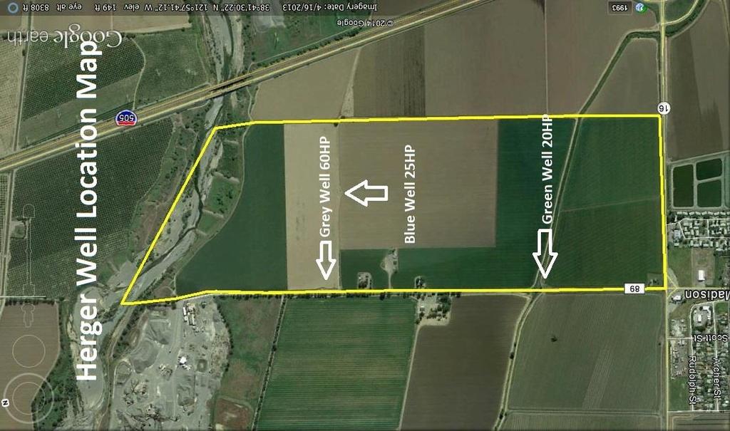
2 Herger Ranch /- Acres Madison, CA Location: This ranch is located on the NW corner of Highway 16 and Road 89 in Madison, CA. The property stretches all of the way from Highway 16 to Cache Creek. Madison is a small town with a population of approximately 500 people. The location of this property gives it an enormous amount of upside potential. The North 25% of the property would make an ideal location for a gravel mine and is within the Cache Creek Management Plan. This property boasts some of the best soils in the world and will efficiently grow just about anything. APN#: Farmable Acres: FSA Base: There are farmable acres according to the Farms Service Agency. The remainder of the acreage is comprised of roads, ditches, 2 homes, 1 shop, and a portion of Cache Creek. There are FSA base acres on the subject property. The following is a breakdown of that base: Crop Name Base Acres Direct Yield CCYield Wheat Corn Barley Total: Acres Wells: Soils: This ranch is comprised of 3 agricultural wells. Each is strategically placed to irrigate the various fields throughout the ranch. The well locations and water quality reports can be found within this brochure. The water table in this area is reported to be less than 200 feet making this ranch inexpensive to irrigate relative to other ranches in California where they are currently pumping water from over 1000 feet deep. This ranch is comprised of Class I & Class II Soils. A detailed soils map & fertility recommendation for both Walnuts & Almonds can be found within this brochure.
3 Mining: Leases: This property is located in an area with an abundance of gravel. Teichert, SYAR, Granite Construction, and Solano Concrete Company are some of the nearby neighbors who have been actively mining for years. This property is purported to contain vast amounts of gravel beneath it. Any potential mining would first need to be approved by the Yolo County Planning Department. The farm is currently leased to Circle G Farms. Circle G is a long time Yolo County Farming family with a great reputation for excellent yields and are easy & honest people to work with. The farm is currently leased for the 2014 crop year, but would be available for a potential buyer to farm in Homes: There are two homes on the subject property. One of them is a 1227 sqft 3 bedrooms 1 bathroom and is currently occupied by a relative of the sellers. The 2 nd home on the property is a 1304 sqft 3 bedroom 1 bathroom home and is currently unoccupied. The home needs a lot of work prior to being re-occupied. Barn: Mineral Rights: Taxes: Price: Listing: Comments: There is an old dairy barn on the subject property. The roof & foundation seem to be in good condition, but the siding needs some TLC. It will make for a great location to store parts and irrigation supplies for any potential buyer. All of the oil, gas, and mineral rights currently held by the sellers will transfer to the buyer at the close of escrow. This property is enrolled in the Willamson Act. Property taxes will remain low at the close of escrow. Call For Price This farm is co listed between Charter Realty and William T. Morgan Real Estate This property has a lot of upside potential. It has gravel, class I &II soils, and at its present time has low carrying costs. This property can be divided into sections; with the part of the ranch being developed into a walnut, pistachio, or almond orchard and the other into a lucrative gravel mine. The property taxes currently stand at less than $10,000 annually and because of its enrolment in the Williamson Act, they won t change at the close of escrow. This ranch is co-listed with William Morgan of William T. Morgan Real Estate.


4 Photo Gallery Class I & II soils produce some of the highest yielding crops in the world. This fresh cut alfalfa is one of many crops this ranch is capable of producing. The neighbors have planted almonds and walnuts are being grown in the vicinity. This is one of three wells on the property. The abundance of groundwater in the area make this ranch inexpensive to irrigate. Photo from the 2014 tomato harvest. California grows more than 90% of U.S. processing tomatoes.
5
6 Sunland Analytical Sunrise Gold Cir.#10 Rancho Cordova, CA (916) Date Reported 07/09/14 Date Submitted 07/03/14 To: William Morgan William T. Morgan Real Estate 10 North East St. Suite 103 Woodland, CA, From: Gene Oliphant, Ph.D. \ Randy Horney General Manager \ Lab Manager The reported analysis was requested for the following: Location : HERGER RANCH-TOMATO Site ID: GREY CARL MAYER Thank you for your business. * For future reference to this analysis please use SUN # WATER ANALYSIS FOR IRRIGATION SUITABILITY Physical Characteristics NOTES ph 7.08 Normal Range ECe 0.91 mmho/cm Increasing Problem Tot.Dissolved Salts ppm Increasing Problem Sodium Adsorp.Ratio (SAR) 3.07 No Problem Chemical Analysis results in ppm results in meq/l Nitrate-N No Problem Phosphate-P 0.02 <.01 Potassium Sulfate-S Chloride No Problem Bicarbonate Increasing Problem Carbonate Sodium Calcium Magnesium Boron 1.89 Increasing Problem
7 Sunland Analytical Sunrise Gold Cir.#10 Rancho Cordova, CA (916) Date Reported 07/09/14 Date Submitted 07/03/14 To: William Morgan William T. Morgan Real Estate 10 North East St. Suite 103 Woodland, CA, From: Gene Oliphant, Ph.D. \ Randy Horney General Manager \ Lab Manager The reported analysis was requested for the following: Location : HERGER RANCH-PENROSE Site ID: GREEN WELL Thank you for your business. * For future reference to this analysis please use SUN # WATER ANALYSIS FOR IRRIGATION SUITABILITY Physical Characteristics NOTES ph 6.93 Normal Range ECe 1.21 mmho/cm Increasing Problem Tot.Dissolved Salts ppm Increasing Problem Sodium Adsorp.Ratio (SAR) 5.59 No Problem Chemical Analysis results in ppm results in meq/l Nitrate-N No Problem Phosphate-P 0.03 <.01 Potassium Sulfate-S Chloride Increasing Problem Bicarbonate Severe Problem Carbonate Sodium Calcium Magnesium Boron 2.13 Severe Problem
8 Sunland Analytical Sunrise Gold Cir.#10 Rancho Cordova, CA (916) Date Reported 07/09/14 Date Submitted 07/03/14 To: William Morgan William T. Morgan Real Estate 10 North East St. Suite 103 Woodland, CA, From: Gene Oliphant, Ph.D. \ Randy Horney General Manager \ Lab Manager The reported analysis was requested for the following: Location : HERGER RANCH-MIDDLE Site ID: BLUE PUMP Thank you for your business. * For future reference to this analysis please use SUN # WATER ANALYSIS FOR IRRIGATION SUITABILITY Physical Characteristics NOTES ph 6.97 Normal Range ECe 1.06 mmho/cm Increasing Problem Tot.Dissolved Salts ppm Increasing Problem Sodium Adsorp.Ratio (SAR) 3.94 No Problem Chemical Analysis results in ppm results in meq/l Nitrate-N No Problem Phosphate-P 0.04 <.01 Potassium Sulfate-S Chloride No Problem Bicarbonate Increasing Problem Carbonate Sodium Calcium Magnesium Boron 2.07 Severe Problem

9 121 58' 23'' W Irrigated Capability Class Yolo County, California (Penrose) ' 1'' W 38 42' 8'' N ' 8'' N 38 40' 43'' N ' 43'' N ' 23'' W N Map Scale: 1:12,900 if printed on A portrait (8.5" x 11") sheet. Meters Feet Map projection: Web Mercator Corner coordinates: WGS84 Edge tics: UTM Zone 10N WGS ' 1'' W Natural Resources Conservation Service Web Soil Survey National Cooperative Soil Survey 6/26/2014 Page 1 of 4
10 Irrigated Capability Class Yolo County, California (Penrose) MAP LEGEND MAP INFORMATION Area of Interest (AOI) Area of Interest (AOI) Soils Soil Rating Polygons Capability Class - I Capability Class - II Capability Class - III Capability Class - IV Capability Class - V Capability Class - VI Capability Class - VII Capability Class - VIII Not rated or not available Soil Rating Lines Capability Class - I Capability Class - II Capability Class - III Capability Class - IV Capability Class - V Capability Class - VI Capability Class - VII Capability Class - VIII Not rated or not available Soil Rating Points Capability Class - I Capability Class - II Capability Class - III Capability Class - IV Capability Class - V Capability Class - VI Capability Class - VII Capability Class - VIII Not rated or not available Water Features Streams and Canals Transportation Rails Interstate Highways US Routes Major Roads Local Roads Background Aerial Photography The soil surveys that comprise your AOI were mapped at 1:20,000. Please rely on the bar scale on each map sheet for map measurements. Source of Map: Natural Resources Conservation Service Web Soil Survey URL: Coordinate System: Web Mercator (EPSG:3857) Maps from the Web Soil Survey are based on the Web Mercator projection, which preserves direction and shape but distorts distance and area. A projection that preserves area, such as the Albers equal-area conic projection, should be used if more accurate calculations of distance or area are required. This product is generated from the USDA-NRCS certified data as of the version date(s) listed below. Soil Survey Area: Yolo County, California Survey Area Data: Version 8, Dec 17, 2013 Soil map units are labeled (as space allows) for map scales 1:50,000 or larger. Date(s) aerial images were photographed: Nov 3, 2010 Apr 29, 2012 The orthophoto or other base map on which the soil lines were compiled and digitized probably differs from the background imagery displayed on these maps. As a result, some minor shifting of map unit boundaries may be evident. Natural Resources Conservation Service Web Soil Survey National Cooperative Soil Survey 6/26/2014 Page 2 of 4
11 Irrigated Capability Class Yolo County, California Penrose Irrigated Capability Class BrA Irrigated Capability Class Summary by Map Unit Yolo County, California (CA113) Map unit symbol Map unit name Rating Acres in AOI Percent of AOI Brentwood silty clay loam, 0 to 2 percent slopes % Ca Capay silty clay % Mf Marvin silty clay loam % Rh Riverwash % Ya Yolo silt loam % Totals for Area of Interest % Natural Resources Conservation Service Web Soil Survey National Cooperative Soil Survey 6/26/2014 Page 3 of 4
12 Irrigated Capability Class Yolo County, California Penrose Description Land capability classification shows, in a general way, the suitability of soils for most kinds of field crops. Crops that require special management are excluded. The soils are grouped according to their limitations for field crops, the risk of damage if they are used for crops, and the way they respond to management. The criteria used in grouping the soils do not include major and generally expensive landforming that would change slope, depth, or other characteristics of the soils, nor do they include possible but unlikely major reclamation projects. Capability classification is not a substitute for interpretations that show suitability and limitations of groups of soils for rangeland, for woodland, or for engineering purposes. In the capability system, soils are generally grouped at three levels-capability class, subclass, and unit. Only class and subclass are included in this data set. Capability classes, the broadest groups, are designated by the numbers 1 through 8. The numbers indicate progressively greater limitations and narrower choices for practical use. The classes are defined as follows: Class 1 soils have few limitations that restrict their use. Class 2 soils have moderate limitations that reduce the choice of plants or that require moderate conservation practices. Class 3 soils have severe limitations that reduce the choice of plants or that require special conservation practices, or both. Class 4 soils have very severe limitations that reduce the choice of plants or that require very careful management, or both. Class 5 soils are subject to little or no erosion but have other limitations, impractical to remove, that restrict their use mainly to pasture, rangeland, forestland, or wildlife habitat. Class 6 soils have severe limitations that make them generally unsuitable for cultivation and that restrict their use mainly to pasture, rangeland, forestland, or wildlife habitat. Class 7 soils have very severe limitations that make them unsuitable for cultivation and that restrict their use mainly to grazing, forestland, or wildlife habitat. Class 8 soils and miscellaneous areas have limitations that preclude commercial plant production and that restrict their use to recreational purposes, wildlife habitat, watershed, or esthetic purposes. Rating Options Aggregation Method: Dominant Condition Component Percent Cutoff: None Specified Tie-break Rule: Higher Natural Resources Conservation Service Web Soil Survey National Cooperative Soil Survey 6/26/2014 Page 4 of 4

13
Pinheiro Ranch 55+/- Acres Orchard Development Ground Orland, CA. Presented By:
 Pinheiro Ranch 55+/- Acres Orchard Development Ground Orland, CA Presented By: Pinheiro Ranch 55+/- Acres Orchard Development Ground Orland, CA Location: This property is located on the SE corner of Road
AG-LAND Investment Brokers 275 Sale Lane Red Bluff, CA Fax Corning Eucalyptus Farm
 AG-LAND Investment Brokers 275 Sale Lane Red Bluff, CA 96080 530-529-4400 Fax 530-527-5042 Corning Eucalyptus Farm Tehama County,, California 1 of 6 deep irrigation wells Drip tubing rolled at the edge
AG-LAND Investment Brokers 275 Sale Lane Red Bluff, CA Fax Paradox Seed Mother Orchard Red Bluff, CA
 AG-LAND Investment Brokers 275 Sale Lane Red Bluff, CA 96080 530-529-4400 Fax 530-527-5042 Paradox Seed Mother Orchard Red Bluff, CA AG-LAND INVESTMENT BROKERS 275 Sale Lane / P. O. Box 896 Red Bluff,
Mule Ranch - Dorris, CA 1,234 +/- acres, Siskiyou County
 AG-LAND Investment Brokers 275 Sale Lane Red Bluff, CA 96080 530-529-4400 Fax 530-527-5042 Mule Ranch - Dorris, CA 1,234 +/- acres, Siskiyou County AG-LAND INVESTMENT BROKERS 275 Sale Lane / P. O. Box
Dairyville Irrigated Pasture & Home. Los Molinos, CA
 Dairyville Irrigated Pasture & Home Los Molinos, CA AG-LAND INVESTMENT BROKERS 275 Sale Lane, Suite 2 / P. O. Box 896 Red Bluff, CA 96080 530.529.4400 office / 530.527.5042 fax 68 th Avenue Irrigated Pasture
Loam Ridge Almond Orchard
 AG-LAND Investment Brokers 645 Antelope Blvd., Suite 17 PO Box 896 Red Bluff, CA 96080 530-529-4400 Fax 530-527-5042 Loam Ridge Almond Orchard Contact: AG-LAND Investment Brokers Prepared by FSA Date:
Dye Creek Orchards Los Molinos, California
 AG-LAND INVESTMENT BROKERS 275Sale Lane / P. O. Box 896 Red Bluff, CA 96080 530.529.4400 office / 530.527.5042 fax Dye Creek Orchards Los Molinos, California Listing Price: $1,950,000. Seller financing
Central Glenn County, CA
 AG-LAND Investment Brokers 275 Sale Lane Red Bluff, CA 96080 530-529-4400 Fax 530-527-5042 AAA&D Almond Orchard 145 +/- Acres Producing Central Glenn County, CA AG-LAND INVESTMENT BROKERS 275 Sale
Web Soil Survey National Cooperative Soil Survey
 99 52' 37'' W Yields of Irrigated Crops (Component): Cotton lint (Lbs) Haskell County, Texas 99 51' 40'' W 33 21' 4'' N 418500 418600 418700 418800 418900 419000 419100 419200 419300 419400 419500 419600
Owens Reeds Creek Ranch. Red Bluff, CA
 Owens Reeds Creek Ranch Red Bluff, CA Owens Reeds Creek Ranch Red Bluff, CA AG-LAND INVESTMENT BROKERS 275 Sale Lane, Suite 2 / P. O. Box 896 Red Bluff, CA 96080 530.529.4400 office / 530.527.5042 fax
AG-LAND Investment Brokers. 275 Sale Lane Red Bluff, CA Fax Northcutt Ranch. Red Bluff, CA
 AG-LAND Investment Brokers 275 Sale Lane Red Bluff, CA 96080 530-529-4400 Fax 530-527-5042 Northcutt Ranch Red Bluff, CA AG-LAND INVESTMENT BROKERS 275 Sale Lane, Suite 2 / P. O. Box 896 Red Bluff,
Capay District Home, Farmland, Shop Orland, CA
 AG-LAND Investment Brokers 275 Sale Lane Red Bluff, CA 96080 530-529-4400 Fax 530-527-5042 Capay District Home, Farmland, Shop Orland, CA Tehama County, California AG-LAND INVESTMENT BROKERS 275 Sale
Web Soil Survey National Cooperative Soil Survey
 289300 289700 290100 290500 83 12' 5'' W 83 13' 37'' W Farmland Classification Ben Hill and Irwin Counties, Georgia 290900 291300 31 46' 8'' N 3514000 3514000 3514400 3514400 3514800 3514800 3515200 3515200
Soil Map Lewis County, Kentucky (Denham Farm, Sand Hill/Trinity, Lewis Co., KY) Web Soil Survey National Cooperative Soil Survey
 Web Soil Survey National Cooperative Soil Survey") 83 37' 43'' W (Denham Farm, Sand Hill/Trinity, Lewis Co., KY) 83 36' 18'' W 38 40' 37'' N 271500 271700 271900 272100 272300 272500 272700 272900 273100 273300 38 40' 37'' N 38 39' 54'' N 4282900 4283100
83 37' 43'' W (Denham Farm, Sand Hill/Trinity, Lewis Co., KY) 83 36' 18'' W 38 40' 37'' N 271500 271700 271900 272100 272300 272500 272700 272900 273100 273300 38 40' 37'' N 38 39' 54'' N 4282900 4283100
The glenlivet farm and refuge An agricultural and recreational investment opportunity.
 offered for sale The glenlivet farm and refuge An agricultural and recreational investment opportunity. 3,106 (+/- sq. ft.) lodge situated on a 304 (+/-) acre farm/waterfowl refuge Arkansas County, Arkansas
Soil Map Lowndes County, Alabama (McEvoy_Gordonsville)
") 524700 525000 525300 525600 525900 526200 3568000 3568000 3567700 3567700 3567400 3567400 3567100 3567100 3566800 3566800 3566500 3566500 3566200 3566200 3565900 3565900 524700 525000 525300 525600 Map
524700 525000 525300 525600 525900 526200 3568000 3568000 3567700 3567700 3567400 3567400 3567100 3567100 3566800 3566800 3566500 3566500 3566200 3566200 3565900 3565900 524700 525000 525300 525600 Map
Gonsalves Ranch, 756 +/- Total Acres Red Bluff, California
 AG-LAND INVESTMENT BROKERS 275 Sale Lane, Suite 2 / P. O. Box 896 Red Bluff, CA 96080 530.529.4400 office / 530.527.5042 fax Gonsalves Ranch, 756 +/- Total Acres Red Bluff, California Listing Price: $675,000.
Alapaha Tract. Alapaha Tract. Berrien County GA Acres Par LL 320 LD 5. Date: 6/6/2017. TractName
 The 996 Planted Slash was st thinned in 0 TractName Alapaha inch equals 74 miles in = 44,786 ft 0 0 60 Miles :,77,40 The 996 Planted Slash was st thinned in 0 TractName Alapaha inch equals miles in = 6,7
THE CITY OF THE VILLAGE PLANNED UNIT DEVELOPMENT DESIGN STATEMENT FOR MULFORD ESTATES
 THE CITY OF THE VILLAGE PLANNED UNIT DEVELOPMENT DESIGN STATEMENT FOR MULFORD ESTATES Revised August 18, 2016, August 10, 2016, September 19,2016 Prepared By: Isch and Associates, Inc. 14848 Bristol Park
Bicycle and pedestrian circulation is scored as follows:
 4. Bicycle and Pedestrian Circulation The mode split for walking and bicycling in the unincorporated areas of County are each less than one percent, which is less than half of the walking and biking mode
4.11 AGRICULTURAL RESOURCES INTRODUCTION ENVIRONMENTAL SETTING. Regional. Project Site Setting
 4.11 AGRICULTURAL RESOURCES 4.11.1 INTRODUCTION This section addresses the potential for the Proposed Project to impact the agricultural resources in and around the Proposed Project location. Following
Stormwater Analysis Report
 Stormwater Analysis Report Solar Panel Array Temple Street (Rt. 14) West Boylston, MA February 24, 216 SITE Prepared for: West Boylston Municipal Lighting Plant 4 Crescent Street West Boylston, MA 1583
REFERENCE MAPS FEMA FIRM MAP NRCS SOILS MAP
 REFERENCE MAPS FEMA FIRM MAP NRCS SOILS MAP Hydrologic Soil Group-Hillsborough County, Florida (Independence Parkway) 27' 58' 56" 27" 58' 57" 2r 58' 32" 27" 58' 33" Map Scale: 1:5,290 if printed on A size
FOR SALE. 1,237.33± Acres, Wasco Kern County, California. CA BRE # Exclusively Presented By: Pearson Realty
 FOR SALE Wasco Almonds & Farmland Opportunity 1,237.33± Acres, Wasco Kern County, California Access to district & well water Quality soils & well water to work with 747.13± acres of almonds, 595.52± acres
Nonirrigated Yields by Map Unit
 Ar: Arents Urban land 8s 800 85 35 50 Ca: Calhoun Henry 3w 3w 400 --- 25 30 Co: Calloway 700 90 38 35 Cs: Collins 800 110 40 40 DuB: 600 75 35 40 DuB3: 575 70 30 --- DuC3: 500 60 20 --- DuD3: EuE: Eustis
Nonirrigated Yields by Map Unit
 Ar: Arents Urban land 8s Ca: Calhoun Henry 3w 3w --- --- --- --- 5.0 Co: Calloway --- 9.0 --- 8.5 6.5 Cs: Collins DuB: DuB3: DuC3: DuD3: --- --- 5.0 --- --- EuE: Eustis 7s --- --- --- --- --- Fa: Falaya
Drainage Letter for Falcon High School Building Expansion
 August 11, 2017 El Paso County Planning and Community Development Department 2880 International Circle, Suite 110 Colorado Springs, CO 80910 ATTN: RE: Mr. Jeff Rice Drainage Letter for Falcon High School
FOR SALE. FOR SALE /- Acres of Prime Almonds in LTRID and Saucelito Irrigation District. Morgan Houchin Tech Ag Financial Group, Inc.
 FOR SALE FOR SALE - 235.72 +/- Acres of Prime Almonds Morgan Houchin P.O. Box 98 Buttonwillow, CA 93206 Neither the Seller, nor makes any representations or warranties, either expressed or implied as to
Rocking R Ranch / Woodland, CA
 ±88.98 Acres Asking Price: $1,600,000 32640 County Road 19, Woodland, CA 95695 APN 025-280-001 Property Highlights y Country Hilltop Manor w/spectacular Coast Range Views y Classic 3 BR/2 BA Two-Story
Willows Warehouse. 16,200+/- Sqft Warehouse Railroad Spur Office & 2.12+/- Acres
 Property Information Location: The property is located near the intersection of Highway 162 and Road 99W. From Highway 162 go East over the railroad tracks. The warehouse is on the SE corner of Highway
3.2 - Agricultural Resources
 County of Yolo - Environmental Education and Sustainability Park Project Draft EIR Agricultural Resources 3.2 - Agricultural Resources This section describes the existing agricultural resources and potential
Custom Soil Resource Report for Columbus County, North Carolina
 United States Department of Agriculture Natural Resources Conservation Service A product of the National Cooperative Soil Survey, a joint effort of the United States Department of Agriculture and other
PHYSICAL SOIL PROPERTIES
 PHYSICAL SOIL PROPERTIES Physical Soil Properties Santa Cruz County, California Scotts Valley Target Physical Soil Properties This table shows estimates of some physical characteristics and features that
APPENDIX E. LESA Models
 APPENDIX E LESA Models LESA ASSESSMENT CALEXICO SOLAR FARM I PHASE A PROJECT AREA CALEXICO SOLAR FARM I PHASE A PROJECT (SW/4 Section 13, S/2 Section 14, S/2 NE/4 Section 15, NW/4 Section 15, T17S, R13E,
offered for sale WAYNE FARM An Agricultural and Recreational Investment Opportunity offered by
 offered for sale WAYNE FARM An Agricultural and Recreational Investment Opportunity 780.93 (+/-) Total Acres Pulaski County, Arkansas offered by Licensed in Arkansas, Louisiana, Mississippi, Tennessee
SW KANSAS IRRIGATION. 4,114 +/- Acres Kearny County, KS $19,335,800. Farm, Ranch & Recreational Real Estate. Presented By:
 4,114 +/- Acres Kearny County, KS $19,335,800 Presented By: Farm, Ranch & Recreational Real Estate For more details on this property, contact us today! SUMMARY: This hard to find irrigated farm property
FOR SALE. Contact: Panola & Quitman Counties, Miss. Total Size Location. Description. Cropland Soils Improvements
 Spring Hill Farm 1,221.08 +/- ac. Panola & Quitman Counties, Miss. Total Size Location Description Cropland Soils Improvements 1,221.08+/- tax ac.; 1,223.21+/- FSA farmland ac.; 1,138.74+/- FSA cropland
Civil Engineering Land Surveying Wetland Science
 Civil Engineering Land Surveying Wetland Science July 5, 2017 Town of Littleton Conservation Commission c/o Amy Green, Conservation Coordinator Shattuck Street Municipal Building 37 Shattuck Street Littleton,
145 ACRES - WABUANSEE COUNTY, KS
 Buyers, Sellers & Land Connected PRICE: $295,000 ACRES: 145 COUNTY: WABAUNSEE STATE: KANSAS Mix-Use Grazing Pasture and CRP in Northeast Wabaunsee County A perfect mix-use 145 acre tract adjoining the
Estimated Use Values of Agricultural Land and Horticultural Land in Prince William
 Questions regarding any statutorily related issues surrounding use- value assessment should be directed to Jason Hughes at the Property Tax Unit, Virginia Department of Taxation. Questions regarding the
1, 566± ACRE B RENT WOOD CREEK FARM SACR AM ENTO -SAN JOAQU IN RIVER DELTA, C ALIFORNIA
 O FFERING M EM O R AN DU M 1, 566± ACRE B RENT WOOD CREEK FARM SACR AM ENTO -SAN JOAQU IN RIVER DELTA, C ALIFORNIA Permanent planting potential Excellent, affordable water Packing facility AGRIBUSINESS
STORMWATER MANAGEMENT REPORT FOR THE BORGATA OUTDOOR EVENT AREA POOL ADDITION
 STORMWATER MANAGEMENT REPORT FOR THE BORGATA OUTDOOR EVENT AREA POOL ADDITION City of Atlantic City, Atlantic County, New Jersey Prepared For: Marina District Development Company, LLC One Borgata Way Atlantic
Rocking W Ranch Millsap, Texas
 Rocking W Ranch Millsap, Texas Approximately 1 hour west of DFW International Airport Interstate Frontage Full professional equine facilities Brazos River frontage with significant water rights Mineral
LESA ASSESSMENT MOUNT SIGNAL SOLAR FARM I PROJECT AREA
 LESA ASSESSMENT MOUNT SIGNAL SOLAR FARM I PROJECT AREA MOUNT SIGNAL SOLAR FARM I PROJECT (SW/4 Section 16, S/2 Section 15, NE/4 Section 14 (portion), N/2 Section 13 (portion) and SE/4 Section 13, T17S,
Site Description. CCR Rule Initial Inflow Design Flood Control System Plan (cont.) 2
 2") Site Description Kentucky Utilities Company (KU) owns and operates Ghent Gypsum Stack, a CCR surface impoundment, at the Ghent Generating Station in Carroll County, Kentucky. The impoundment is permitted
Site Description Kentucky Utilities Company (KU) owns and operates Ghent Gypsum Stack, a CCR surface impoundment, at the Ghent Generating Station in Carroll County, Kentucky. The impoundment is permitted
Estimated Use Values of Agricultural Land and Horticultural Land in King William
 Questions regarding any statutorily related issues surrounding use- value assessment should be directed to Jason Hughes at the Property Tax Unit, Virginia Department of Taxation. Questions regarding the
Estimated Use Values of Agricultural Land and Horticultural Land in Gloucester
 Questions regarding any statutorily related issues surrounding use- value assessment should be directed to Jason Hughes at the Property Tax Unit, Virginia Department of Taxation. Questions regarding the
Appendix M Land Evaluation and Site Assessment (Calipatria I, Midway I and Midway II)
") Appendix M Land Evaluation and Site Assessment (Calipatria I, Midway I and Midway II) LESA ASSESSMENT CALIPATRIA SOLAR FARM I PROJECT AREA CALIPATRIA SOLAR FARM I PROJECT (Section 10 (portion), T12S, R14E,
Appendix M Land Evaluation and Site Assessment (Calipatria I, Midway I and Midway II) LESA ASSESSMENT CALIPATRIA SOLAR FARM I PROJECT AREA CALIPATRIA SOLAR FARM I PROJECT (Section 10 (portion), T12S, R14E,
Appendix D. Land Evaluation Site Assessment System
 Appendix D Land Evaluation Site Assessment System Town of Dewey Comprehensive Plan 2009 PORTAGE COUNTY S LAND EVALUATION SITE ASSESSMENT SYSTEM A tool to help local communities understand the agricultural
Section 1 Estimating the Use Value of Agricultural Land
 Section 1 Estimating the Use Value of Agricultural Land The State Land Evaluation Advisory Council (SLEAC) is required to base its estimates of the use value of agricultural and horticultural lands on
The Lund Ranch. 1,354.1 Ac. Farm Ground The Lund Ranch Tracy, CA. Schuil & Associates
 The Lund Ranch 1,354.1 Ac. Farm Ground The Lund Ranch Tracy, CA Schuil & Associates 559-734-1700 www.schuil.com CalDRE: 00845607 Listing The Lund Ranch Price: $22,342,560 Location: Size: The historic Lund
Estimated Use Values of Agricultural Land and Horticultural Land in Louisa
 Questions regarding any statutorily related issues surrounding use- value assessment should be directed to Jason Hughes at the Property Tax Unit, Virginia Department of Taxation. Questions regarding the
Estimated Use Values of Agricultural Land and Horticultural Land in Nottoway
 Questions regarding any statutorily related issues surrounding use- value assessment should be directed to Jason Hughes at the Property Tax Unit, Virginia Department of Taxation. Questions regarding the
Estimated Use Values of Agricultural Land and Horticultural Land in Richmond
 Questions regarding any statutorily related issues surrounding use- value assessment should be directed to Jason Hughes at the Property Tax Unit, Virginia Department of Taxation. Questions regarding the
Estimated Use Values of Agricultural and Horticultural Land in Augusta
 Questions regarding any statutorily related issues surrounding use-value assessment should be directed to Jason Hughes at the Property Tax Unit, Virginia Department of Taxation. Questions regarding the
Estimated Use Values of Agricultural and Horticultural Land in Henry
 Questions regarding any statutorily related issues surrounding use-value assessment should be directed to Jason Hughes at the Property Tax Unit, Virginia Department of Taxation. Questions regarding the
Estimated Use Values of Agricultural Land and Horticultural Land in Fluvanna
 Questions regarding any statutorily related issues surrounding use- value assessment should be directed to Jason Hughes at the Property Tax Unit, Virginia Department of Taxation. Questions regarding the
Estimated Use Values of Agricultural Land and Horticultural Land in Southampton
 Questions regarding any statutorily related issues surrounding use- value assessment should be directed to Jason Hughes at the Property Tax Unit, Virginia Department of Taxation. Questions regarding the
Estimated Use Values of Agricultural Land and Horticultural Land in Suffolk
 Questions regarding any statutorily related issues surrounding use- value assessment should be directed to Jason Hughes at the Property Tax Unit, Virginia Department of Taxation. Questions regarding the
Estimated Use Values of Agricultural Land and Horticultural Land in Westmoreland
 Questions regarding any statutorily related issues surrounding use- value assessment should be directed to Jason Hughes at the Property Tax Unit, Virginia Department of Taxation. Questions regarding the
Estimated Use Values of Agricultural and Horticultural Land in Suffolk
 Questions regarding any statutorily related issues surrounding use-value assessment should be directed to Jason Hughes at the Property Tax Unit, Virginia Department of Taxation. Questions regarding the
Estimated Use Values of Agricultural Land and Horticultural Land in Isle Of Wight
 Questions regarding any statutorily related issues surrounding use- value assessment should be directed to Jason Hughes at the Property Tax Unit, Virginia Department of Taxation. Questions regarding the
Land For Sale ACREAGE:
 Land For Sale ACREAGE: 526.85 Acres, m/l LOCATION: Burt County, NE Property Key Features Combination High-Quality, Income-Producing Cropland and Recreational Land 329.04 Acres Planted to Cropland 296.4
Land Sales Specialists Setting the trend for how Real Estate is sold in the Midwest.
 Land Sales Specialists Setting the trend for how Real Estate is sold in the Midwest. www.barnesrealty.com 18156 Hwy 59 Mound City, MO 64470 (660) 442-3177 1711 Oregon Hiawatha, KS 66434 (785) 742-4580
Land Evaluation and Site Assessment Model
 Land Evaluation and Site Assessment Model Citizens Imperial Solar, LLC Project Imperial County, CA June 6, 2018 This page is intentionally blank. Land Evaluation and Site Assessment Model Citizens Imperial
FOR SALE. Arvin-Rancho Rd. Farmland Opportunity ± acres, Kern County, California. CA BRE #
 FOR SALE Arvin-Rancho Rd. Farmland Opportunity David Rd Edison Rd Rancho Rd Site 1 Site 2 Offsite well 371.37± acres, Kern County, California District and Well Water Strong Soils Located in White Wolf
East Angela Farm ANGELA, MONTANA. Hunting Ranching Fly Fishing Conservation
 East Angela Farm ANGELA, MONTANA Hunting Ranching Fly Fishing Conservation East Angela Far m ANGELA, MONTANA Introduction: East Angela Farm is an agricultural farm and ranch in eastern Montana. Located
Berkshire Hathaway Home Services Vacant Acres Halsted Rd. Rockford, IL 61114
 Berkshire Hathaway Home Services 36.13 Vacant Acres Halsted Rd. Rockford, IL 61114 Offered by Randy Erwin & Natalie Torres Broker Associates Berkshire Hathaway Home Services 1710 South Eastwood Dr. Woodstock,
Wisconsin Conservation Planning Technical Note WI-1
 Wisconsin Conservation Planning Technical Note WI-1 Introduction Companion Document to NRCS FOTG Standard 590, Nutrient Management September 2007 Definition of Nutrient Management Managing the amount,
OUTDOOR PROPERTIES. Monroe Land & Livestock
 OUTDOOR PROPERTIES of Monroe Land & Livestock INTRODUCTION Monroe Land and Livestock is an opportunity to own an incredible income generating property. Encompassing 2300+/- total deeded acres, this hay
HARVEST PARK/ZIEGLER MIXED USE LOT 2 CITY OF FORT COLLINS, CO
 EROSION CONTROL REPORT / STORMWATER MANAGEMENT PLAN FOR HARVEST PARK/ZIEGLER MIXED USE LOT 2 CITY OF FORT COLLINS, CO Prepared by: Interwest Consulting Group 1218 West Ash, Suite C Windsor, Colorado 80550
Managing Salinity in Walnuts. Janet Caprile Farm Advisor UC Cooperative Extension Contra Costa & Alameda Counties
 Managing Salinity in Walnuts Janet Caprile Farm Advisor UC Cooperative Extension Contra Costa & Alameda Counties jlcaprile@ucdavis.edu Quad County Walnut Institute Stockton - March 6, 2014 Higher Salinity
UNDIVIDED ONE-HALF INTEREST IN A ± ACRE PARCEL
 FOR SALE UNDIVIDED ONE-HALF INTEREST IN A ADJACENT TO THE SACRAMENTO INTERNATIONAL AIRPORT, SACRAMENTO, CA 95835 CONTACT US RANDY GRIMSMAN Senior Vice President Lic. 00857338 +1 916 446 8745 randall.grimsman@cbre.com
Panhandle Green Valley Ranch
 Panhandle Green Valley Ranch A well maintained combination ranch and farm with 2,898± acres in Kimball County, Nebraska. Property Highlights List Price $2,600,000 Location/Background The Panhandle Green
Example Waste Utilization / Nutrient Management Plan. Revised 7/05
 Example Waste Utilization / Nutrient Management Plan Revised 7/05 Step 1 - Locate Operation Locate on Topo Map first. Note if any named streams or water bodies present within 2000 feet of the application
Goertz Farm Phillips County Malta, Montana
 Goertz Farm Phillips County Malta, Montana Clifton M. Berglee, D.V.M. (Listing Broker) 406-860-7319 cell cberglee@montwyowest.com Phone: (406) 628-2341 (office) Website: montwyowest.com P.O. Box 578, Laurel,
APPENDIX I LESA MODELS
 APPENDIX I LESA MODELS LESA ASSESSMENT SEVILLE 4 SOLAR PROJECT HORIZONTAL SINGLE-AXIS TRACKING ARRAY (T16S, R12E, S25, SBB&M) IMPERIAL COUNTY, CALIFORNIA July 2017 EMA Report No. 2375-01 Prepared for:
27.7 ACRES CASS COUNTY, MO
 Buyers, Sellers & Land Connected 2. ACRES CASS COUNTY, MO PRICE: $20,500 ACRES: 2. COUNTY: Cass STATE: Missouri For More Information contact: STEVE MOTT, Land Broker 16.1.201 SteveMott@MidwestLandGroup.com
For Sale. Exclusively Presented By: PEARSON REALTY
 For Sale R iver R anch 900 Shares Lemoore Water Stock 1,180± Acres Drip Irrigation System 465± Acres Mature Pomegranates on Drip 715± Acres Tomatoes on Drip 960± Acres Tile Drain Kings River Frontage Exclusively
LESA ASSESSMENT LAUREL SOLAR PROJECT (T16S, R12E, S26, SBB&M)
") LESA ASSESSMENT LAUREL SOLAR PROJECT (T16S, R12E, S26, SBB&M) IMPERIAL COUNTY, CALIFORNIA May 2017 EMA Report No. 2377-01 Prepared for: 90FI 8me LLC 111 Woodmere Road, Suite 250 Folsom, CA 95630 ENVIRONMENTAL
LESA ASSESSMENT LAUREL SOLAR PROJECT (T16S, R12E, S26, SBB&M) IMPERIAL COUNTY, CALIFORNIA May 2017 EMA Report No. 2377-01 Prepared for: 90FI 8me LLC 111 Woodmere Road, Suite 250 Folsom, CA 95630 ENVIRONMENTAL
FOR SALE. Baroncini s Breckenridge Ranch. 4,631.78± Acres Kern County, California. CA BRE #
 FOR SALE Baroncini s Breckenridge Ranch 178 Rio Bravo Country Club Brenckridge Road 99 204 58 184 Brenckridge Road Comanche Road Comanche Road Towerline Road General Beale Road 4,631.78± Acres Kern County,
Harding Real Estate Vacant Acres Thompson Rd., Wonder Lake, IL. Presented By: Randy Erwin, Broker Associate Natalie Torres, Broker Associate
 Harding Real Estate 193.93 Vacant Acres Thompson Rd., Wonder Lake, IL Presented By: Randy Erwin, Broker Associate Natalie Torres, Broker Associate Harding Real Estate 1710 South Eastwood Dr. Woodstock,
Custom Soil Resource Report for Wright County, Minnesota
 United States Department of Agriculture Natural Resources Conservation Service A product of the National Cooperative Soil Survey, a joint effort of the United States Department of Agriculture and other
Central California Pistachios & Farmland Kings County, California
 Kings County, California 5,014.93± Assessed Acres District water, well water and ditch stock Young pistachios Additional land to plant permanent crops and/or to mitigate SGMA Tax benefits Good locations
FARMLAND FOR SALE HAMPER PLANTATION Woodruff County, Arkansas
 FARMLAND FOR SALE HAMPER PLANTATION Woodruff County, Arkansas OFFERED BY GLAUB FARM MANAGEMENT MANAGEMENT REAL ESTATE CONSULTING GINVESTMENTS LAND AUCTIONS For Additional Information Contact: Glaub Farm
STORMWATER POLLUTION PREVENTION PLAN (SWPPP)
") SIEMENS INDUSTRY, INC. STORMWATER POLLUTION PREVENTION PLAN (SWPPP) COLUMBIA UNIVERSITY/SUN EDISON REMOTE METERING SOLAR ENERGY PROJECT JOHNSON FARM, 121 JOHNSON ROAD CHESTER, NEW YORK 10918 TAX LOT SECTION
SIEMENS INDUSTRY, INC. STORMWATER POLLUTION PREVENTION PLAN (SWPPP) COLUMBIA UNIVERSITY/SUN EDISON REMOTE METERING SOLAR ENERGY PROJECT JOHNSON FARM, 121 JOHNSON ROAD CHESTER, NEW YORK 10918 TAX LOT SECTION
Soil Testing and Nutrient Management. Craig Cogger Soil Scientist WSU Puyallup
 Soil Testing and Nutrient Management Craig Cogger Soil Scientist WSU Puyallup Soil Testing Nutrients Soil Quality Contaminants Biological Simple Soil Quality Tests Texture Structure Color Texture: Proportions
Maps for Nutrient Management Planning
 Maps for Nutrient Management Planning Table of Contents Introduction... 3 Dry Poultry NMP Exceptions... 3 Making a Base Map... 3 NRCS Toolkit... 3 Online Maps... 4 Photocopied Maps... 4 Additional or Supporting
Grapes, Wine $95,231,000 Milk $42,517,000 Nursery Stock $26,408,000 Pears, Bartlett $26,100,000 Corn, Field $10,295,000
 This section of the Draft Environmental Impact Report (EIR) describes the agricultural resources that exist within the Planning Area. Sources utilized in this section to assess impacts of the project include
Sloughhouse Orchards. 3 Bed 3 Bath 2,100 Sqft Home 71+/- Acre Walnut Orchard
 Property Information Location: From Highway 16 go west on Dillard Road. Turn right 0.4 miles past the intersection of Dillard & Highway 16. The property is located at the end of the driveway behind a locked
4.2 Agriculture and Forestry Resources
 The purpose of this Section is to identify existing agriculture and forest resources within the Project area, analyze potential agriculture and forest resources associated with the development of the proposed
APPENDIX II Soil Testing Plan
 APPENDIX II Soil Testing Plan After rough backfilling and grading, Alcoa will place permanent markers on 500-foot centers in the regraded area to delineate a 5.7-acre grid system for monitoring postmine
Custom Soil Resource Report for Polk County, Wisconsin
 United States Department of Agriculture Natural Resources Conservation Service A product of the National Cooperative Soil Survey, a joint effort of the United States Department of Agriculture and other
Lecture 8: Irrigation Water Quality
 The Islamic University of Gaza- Civil Engineering Department Irrigation and Drainage- ECIV 5327 Lecture 8: Irrigation Water Quality Prepared by Husam Al-Najar Physical Parameters used in the evaluation
Produced Water Quality Limits for Irrigated Agriculture. Robert Flynn, Ph.D. Extension Plant Sciences, NMSU
 Produced Water Quality Limits for Irrigated Agriculture Robert Flynn, Ph.D. Extension Plant Sciences, NMSU rflynn@nmsu.edu Introduction Water Quality Affects Soil Productivity Crop Performance Poor Water
Hyde County Cropland Retreat /- Deeded Acres
 Hyde County Cropland Retreat 426.67+/- Deeded Acres Signature Property Todd Schuetzle Broker Cell: 605-280-3115 todd@placetohunt.com Graham Schuetzle Broker Associate Cell: 605-220-4014 dakotalandco@gmail.com
Farm with Livestock Production Buildings
 72 Acres m/l Iowa County, IA $895,000 Farm with Livestock Production Buildings Feed Mill & Grain Storage Barns Nurseries Manure Storage *8 A M/L House, Shop & Barn Excluded 2 WF Buildings Metal Buildings
Emmett Ranch 194. Gem County, Idaho. Executive Summary Provided by: Garren Apple (208)
") Emmett Ranch 194 Gem County, Idaho Executive Summary Provided by: Garren Apple (208) 546-1194 www.agproconsulting.net EMMETT FARM 194 Gem County - Idaho Location - Description: Access: Features: Water
Emmett Ranch 194 Gem County, Idaho Executive Summary Provided by: Garren Apple (208) 546-1194 www.agproconsulting.net EMMETT FARM 194 Gem County - Idaho Location - Description: Access: Features: Water
INVEST IN WATER - INVEST IN NEBRASKA. Offered exclusively by:
 SANDHILLS FARM & RANCH 3924.49 +/- ACRES LOGAN COUNTY, NE INVEST IN WATER - INVEST IN NEBRASKA REDUCED Offered exclusively by: AGSTAR LAND BROKERS, LLC RICHARD DAWSON, BROKER & LISTING AGENT MOBILE: (308)