AG-LAND Investment Brokers. 275 Sale Lane Red Bluff, CA Fax Northcutt Ranch. Red Bluff, CA
|
|
|
- Moris Stanley
- 5 years ago
- Views:
Transcription


1 AG-LAND Investment Brokers 275 Sale Lane Red Bluff, CA Fax Northcutt Ranch Red Bluff, CA


2

3


4
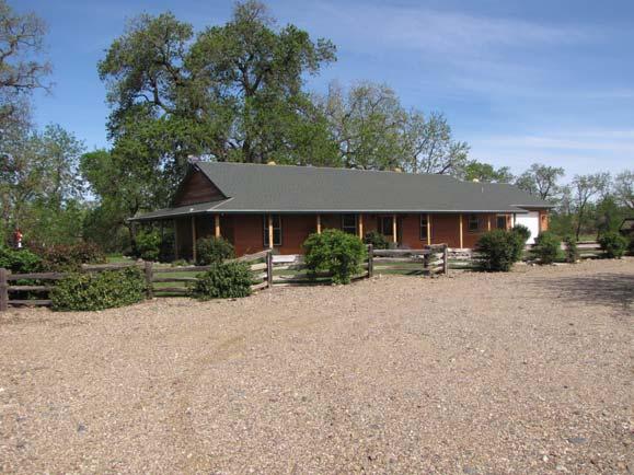
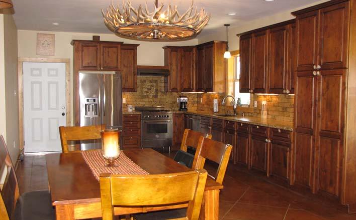
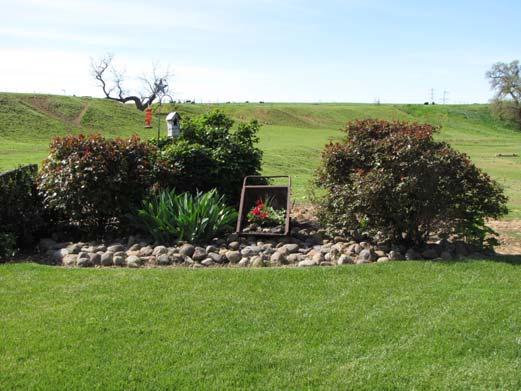
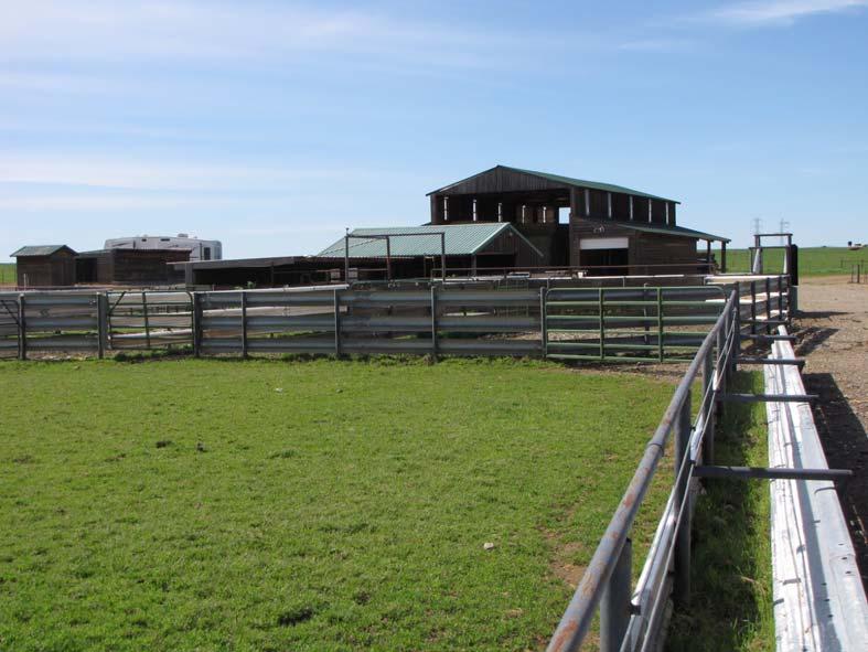
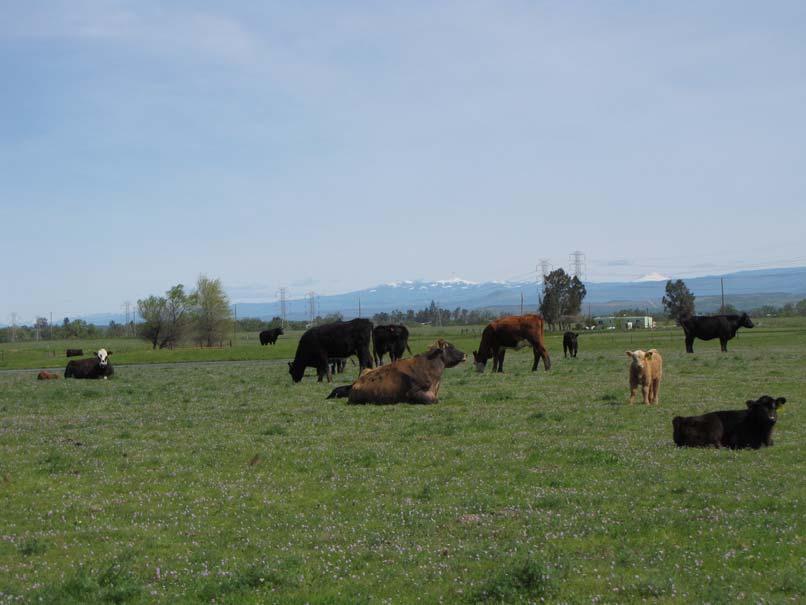
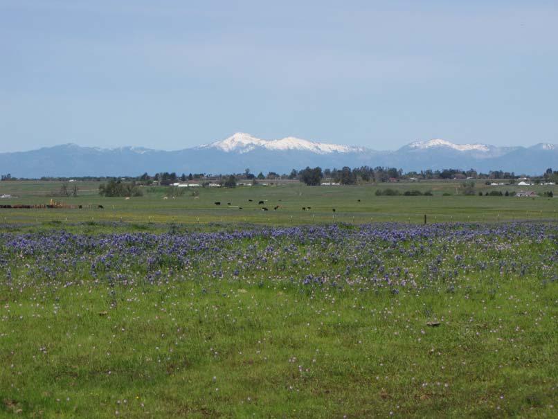
5 AG-LAND INVESTMENT BROKERS 275 Sale Lane, Suite 2 / P. O. Box 896 Red Bluff, CA office / fax Northcutt Ranch, Red Bluff, California Property: 456 +/- acres used for winter cattle grazing. The ranch is improved with a nicely landscaped custom ranch style home and a beef cattle setup for a headquarters base of operations. Location: The ranch sets on the south bank of Red Bank Creek, 4 miles SW of Red Bluff, CA. The property is bordered on the east by Paskenta Road. The address is Paskenta Road, Red Bluff, CA Home: Nicely landscaped custom 3 bedroom, 2 bathroom ranch style home built in It has approx. 1,608 sqft of living space plus attached 529 sqft finished oversized single car garage. Granite counters, hickory cabinets and doors, quality appliances, stained concrete floors plus fire suppression sprinklers. Central HVAC, wood stove plus ceiling fans in each room. Hardy plank siding, composition roof plus wrap around porches on 3 sides of the home. There is also a detached garden storage area fully wood framed, hardy plank sided, composition roof, on concrete slab with roll up door for access. Outbuildings: The building improvements consist of a hay barn with 372 sq ft studio apartment, 364 sq ft shop with concrete slab floor, equipment storage area, approximately 2,000 sq ft of hay storage, interior tack room with an outside ferrior working area. 576 sq ft wood sided steel roof dog kennel with 18 interior separate steel cages all on concrete flooring with sloped drainage for easy daily cleaning into a separate septic system. All outbuildings set on a slightly sloping well graveled farmstead which provides easy winter time access. Cattle Facilities: Steel guard rail corrals and feed bunks in exterior perimeter feeding areas at two locations in the corral area. The feed bunk runs are approximately 400 in length. There are 4 working corral areas with a 60 curved, adjustable lead up to a covered cattle hospital area. Inside the cattle hospital area is a vet supply storage area along with 2 hospital pens for use in calving heifers or addressing sick cattle. Feed mangers and water troughs are installed. The cattle loading area accommodates large semi- trucks all made of steel and concrete. There are 2 stack yard feeding areas located in the middle of the ranch used to store hay for winter supplementation. One yard is 100 x 300, the other 80 x 120. Both stack The information contained herein is from sources deemed reliable, however, accuracy is not guaranteed. AG-LAND Investment Brokers assumes no liability as to errors, omissions or future operating and investment results. Buyer assumes responsibility to perform their own investigation and due diligence. This offering is subject to prior sale, price change or withdrawal from market without notice.
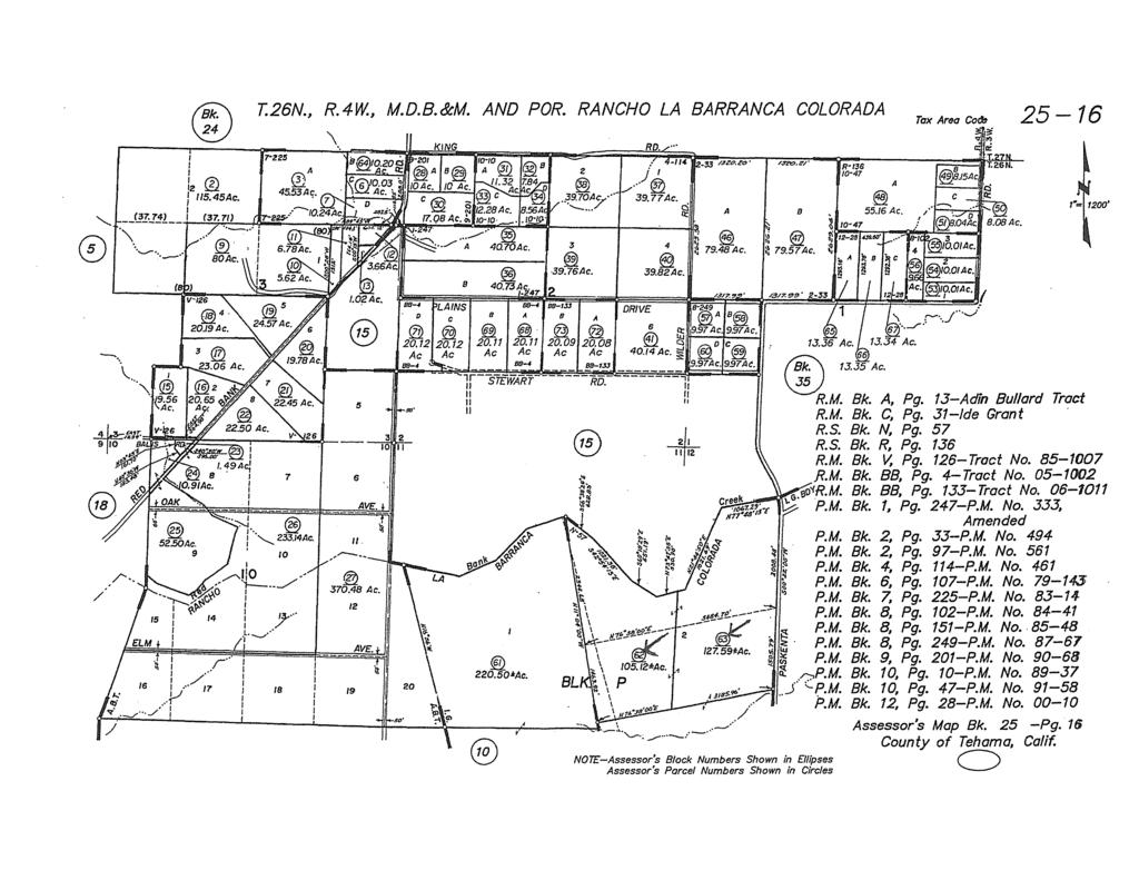
6 AG-LAND INVESTMENT BROKERS 275 Sale Lane, Suite 2 / P. O. Box 896 Red Bluff, CA office / fax yards have perimeter guard rail lined feeding areas where the feed can be stored and fed. Water: There is a 6 inch cased domestic well located within the farmstead with a submersible pump providing water for the residence and livestock. The tankless system is protected by a wood frame and sided pump house. In the pump house is a large sized air compressor. There is a single reservoir in the middle of the property which is spring fed for year around stock water Cattle Lease: The ranch is not leased as the owner grazes the pastures with their own cattle. This property would normally lease for $25-30 per acre for a 6 month grazing season between the months of November through May annually. Topography: The elevations range between 330 to 400. The land runs from a low elevation in Red Bank Creek to the highest point being adjacent to its southern property boundary. The land is slightly sloping with minor drains running from west to east draining across Paskenta Road. The property is unwooded with access by vehicle anywhere during summer and most winter months. Wildlife: Mineral Rights: Turkey, geese, dove and quail are ound within Red Bank Creek. All mineral, oil and gas rights owned by seller are included. Soils: Per Natural Resource Conservation Service, the soils consist of approx. 6% Maywood Loam Class I, 32% Arbuckle- Perkins Gravelly Loam Class II, 22% Kimball Loam Class III and 30% Corning-Redding Gravelly Loam Class IV. The balance of the land is within Red Bank Creek or unrated. In the past, some of the land has been dry farmed to grain crops. Zoning: EA-AP (40 acre minimum). It is enrolled in the California Land Conservation Act aka Williamson Act to keep property taxes low. Current property taxes are $1,357 per year. Tehama County Assessor Parcel Numbers , , , & The entire property has a Record of Survey Map recorded in The information contained herein is from sources deemed reliable, however, accuracy is not guaranteed. AG-LAND Investment Brokers assumes no liability as to errors, omissions or future operating and investment results. Buyer assumes responsibility to perform their own investigation and due diligence. This offering is subject to prior sale, price change or withdrawal from market without notice.
7 AG-LAND INVESTMENT BROKERS 275 Sale Lane, Suite 2 / P. O. Box 896 Red Bluff, CA office / fax Comments: This ranch will make an outstanding headquarters for a local cattleman having the facilities to accommodate all classes of beef cattle. Approx. 180 acres of class 1 and 2 soils maybe suitable for development of orchards or planted to permanent pasture for livestock. The location is just a short drive from Red Bluff and is known for reliable groundwater. Listing Price: Contact Info: $1,520,000 cash to Seller. Please contact Bert Owens or Sam Mudd. Bert Owens California Brokers License Number , office / , cell bert.owens@aglandbrokers.com, website Sam Mudd California Brokers License Number , office / , cell sam.mudd@aglandbrokers.com, website The information contained herein is from sources deemed reliable, however, accuracy is not guaranteed. AG-LAND Investment Brokers assumes no liability as to errors, omissions or future operating and investment results. Buyer assumes responsibility to perform their own investigation and due diligence. This offering is subject to prior sale, price change or withdrawal from market without notice.

8 122 17' 20'' W Irrigated Capability Class Tehama County, California (Northcutt Ranch) ' 50'' W 40 7' 44'' N ' 44'' N 40 6' 12'' N ' 12'' N ' 20'' W N Map Scale: 1:13,800 if printed on A portrait (8.5" x 11") sheet. Meters Feet Map projection: Web Mercator Corner coordinates: WGS84 Edge tics: UTM Zone 10N WGS ' 50'' W Natural Resources Conservation Service Web Soil Survey National Cooperative Soil Survey 4/16/2019 Page 1 of 5
9 Irrigated Capability Class Tehama County, California (Northcutt Ranch) MAP LEGEND MAP INFORMATION Area of Interest (AOI) Area of Interest (AOI) Soils Soil Rating Polygons Capability Class - I Capability Class - II Capability Class - III Capability Class - IV Capability Class - V Capability Class - VI Capability Class - VII Capability Class - VIII Not rated or not available Soil Rating Lines Capability Class - I Capability Class - II Capability Class - III Capability Class - IV Capability Class - V Capability Class - VI Capability Class - VII Capability Class - VIII Not rated or not available Soil Rating Points Capability Class - I Capability Class - II Capability Class - III Capability Class - IV Capability Class - V Capability Class - VI Capability Class - VII Capability Class - VIII Not rated or not available Water Features Streams and Canals Transportation Rails Interstate Highways US Routes Major Roads Local Roads Background Aerial Photography The soil surveys that comprise your AOI were mapped at 1:20,000. Please rely on the bar scale on each map sheet for map measurements. Source of Map: Natural Resources Conservation Service Web Soil Survey URL: Coordinate System: Web Mercator (EPSG:3857) Maps from the Web Soil Survey are based on the Web Mercator projection, which preserves direction and shape but distorts distance and area. A projection that preserves area, such as the Albers equal-area conic projection, should be used if more accurate calculations of distance or area are required. This product is generated from the USDA-NRCS certified data as of the version date(s) listed below. Soil Survey Area: Tehama County, California Survey Area Data: Version 12, Sep 13, 2018 Soil map units are labeled (as space allows) for map scales 1:50,000 or larger. Date(s) aerial images were photographed: 25, 2017 Apr 11, 2015 Oct The orthophoto or other base map on which the soil lines were compiled and digitized probably differs from the background imagery displayed on these maps. As a result, some minor shifting of map unit boundaries may be evident. Natural Resources Conservation Service Web Soil Survey National Cooperative Soil Survey 4/16/2019 Page 2 of 5
10 Irrigated Capability Class Tehama County, California Northcutt Ranch Irrigated Capability Class Au AvA Ay CyB Map unit symbol Map unit name Rating Acres in AOI Percent of AOI Arbuckle gravelly fine sandy loam, 0 to 2 percent slopes, MLRA 17 Arbuckle gravelly loam, 0 to 2 percent slopes, MLRA 17 Arbuckle gravelly loam, clayey substratum, channeled Corning-Redding gravelly loams, 0 to 5 percent slopes % % % % Czx Cortina complex % KpA Kimball loam, 0 to 3 percent slopes Me Maywood loam, 0 to 3 percent slopes PkA Perkins gravelly loam, 0 to 3 percent slopes, MLRA 17 PkB Perkins gravelly loam, 3 to 8 percent slopes Rg Red Bluff gravelly loam, 0 to 3 percent slopes % % % % % Rr Riverwash % W Water % Totals for Area of Interest % Natural Resources Conservation Service Web Soil Survey National Cooperative Soil Survey 4/16/2019 Page 3 of 5
11 Irrigated Capability Class Tehama County, California Northcutt Ranch Description Land capability classification shows, in a general way, the suitability of soils for most kinds of field crops. Crops that require special management are excluded. The soils are grouped according to their limitations for field crops, the risk of damage if they are used for crops, and the way they respond to management. The criteria used in grouping the soils do not include major and generally expensive landforming that would change slope, depth, or other characteristics of the soils, nor do they include possible but unlikely major reclamation projects. Capability classification is not a substitute for interpretations that show suitability and limitations of groups of soils for rangeland, for woodland, or for engineering purposes. In the capability system, soils are generally grouped at three levels-capability class, subclass, and unit. Only class and subclass are included in this data set. Capability classes, the broadest groups, are designated by the numbers 1 through 8. The numbers indicate progressively greater limitations and narrower choices for practical use. The classes are defined as follows: Class 1 soils have few limitations that restrict their use. Class 2 soils have moderate limitations that reduce the choice of plants or that require moderate conservation practices. Class 3 soils have severe limitations that reduce the choice of plants or that require special conservation practices, or both. Class 4 soils have very severe limitations that reduce the choice of plants or that require very careful management, or both. Class 5 soils are subject to little or no erosion but have other limitations, impractical to remove, that restrict their use mainly to pasture, rangeland, forestland, or wildlife habitat. Class 6 soils have severe limitations that make them generally unsuitable for cultivation and that restrict their use mainly to pasture, rangeland, forestland, or wildlife habitat. Class 7 soils have very severe limitations that make them unsuitable for cultivation and that restrict their use mainly to grazing, forestland, or wildlife habitat. Class 8 soils and miscellaneous areas have limitations that preclude commercial plant production and that restrict their use to recreational purposes, wildlife habitat, watershed, or esthetic purposes. Rating Options Aggregation Method: Dominant Condition Component Percent Cutoff: None Specified Natural Resources Conservation Service Web Soil Survey National Cooperative Soil Survey 4/16/2019 Page 4 of 5
12 Irrigated Capability Class Tehama County, California Northcutt Ranch Tie-break Rule: Higher Natural Resources Conservation Service Web Soil Survey National Cooperative Soil Survey 4/16/2019 Page 5 of 5
13
14
15
16
17
18
AG-LAND Investment Brokers 275 Sale Lane Red Bluff, CA Fax Corning Eucalyptus Farm
 AG-LAND Investment Brokers 275 Sale Lane Red Bluff, CA 96080 530-529-4400 Fax 530-527-5042 Corning Eucalyptus Farm Tehama County,, California 1 of 6 deep irrigation wells Drip tubing rolled at the edge
Dairyville Irrigated Pasture & Home. Los Molinos, CA
 Dairyville Irrigated Pasture & Home Los Molinos, CA AG-LAND INVESTMENT BROKERS 275 Sale Lane, Suite 2 / P. O. Box 896 Red Bluff, CA 96080 530.529.4400 office / 530.527.5042 fax 68 th Avenue Irrigated Pasture
Mule Ranch - Dorris, CA 1,234 +/- acres, Siskiyou County
 AG-LAND Investment Brokers 275 Sale Lane Red Bluff, CA 96080 530-529-4400 Fax 530-527-5042 Mule Ranch - Dorris, CA 1,234 +/- acres, Siskiyou County AG-LAND INVESTMENT BROKERS 275 Sale Lane / P. O. Box
Owens Reeds Creek Ranch. Red Bluff, CA
 Owens Reeds Creek Ranch Red Bluff, CA Owens Reeds Creek Ranch Red Bluff, CA AG-LAND INVESTMENT BROKERS 275 Sale Lane, Suite 2 / P. O. Box 896 Red Bluff, CA 96080 530.529.4400 office / 530.527.5042 fax
AG-LAND Investment Brokers 275 Sale Lane Red Bluff, CA Fax Paradox Seed Mother Orchard Red Bluff, CA
 AG-LAND Investment Brokers 275 Sale Lane Red Bluff, CA 96080 530-529-4400 Fax 530-527-5042 Paradox Seed Mother Orchard Red Bluff, CA AG-LAND INVESTMENT BROKERS 275 Sale Lane / P. O. Box 896 Red Bluff,
Pinheiro Ranch 55+/- Acres Orchard Development Ground Orland, CA. Presented By:
 Pinheiro Ranch 55+/- Acres Orchard Development Ground Orland, CA Presented By: Pinheiro Ranch 55+/- Acres Orchard Development Ground Orland, CA Location: This property is located on the SE corner of Road
Central Glenn County, CA
 AG-LAND Investment Brokers 275 Sale Lane Red Bluff, CA 96080 530-529-4400 Fax 530-527-5042 AAA&D Almond Orchard 145 +/- Acres Producing Central Glenn County, CA AG-LAND INVESTMENT BROKERS 275 Sale
Dye Creek Orchards Los Molinos, California
 AG-LAND INVESTMENT BROKERS 275Sale Lane / P. O. Box 896 Red Bluff, CA 96080 530.529.4400 office / 530.527.5042 fax Dye Creek Orchards Los Molinos, California Listing Price: $1,950,000. Seller financing
Loam Ridge Almond Orchard
 AG-LAND Investment Brokers 645 Antelope Blvd., Suite 17 PO Box 896 Red Bluff, CA 96080 530-529-4400 Fax 530-527-5042 Loam Ridge Almond Orchard Contact: AG-LAND Investment Brokers Prepared by FSA Date:
Capay District Home, Farmland, Shop Orland, CA
 AG-LAND Investment Brokers 275 Sale Lane Red Bluff, CA 96080 530-529-4400 Fax 530-527-5042 Capay District Home, Farmland, Shop Orland, CA Tehama County, California AG-LAND INVESTMENT BROKERS 275 Sale
Gonsalves Ranch, 756 +/- Total Acres Red Bluff, California
 AG-LAND INVESTMENT BROKERS 275 Sale Lane, Suite 2 / P. O. Box 896 Red Bluff, CA 96080 530.529.4400 office / 530.527.5042 fax Gonsalves Ranch, 756 +/- Total Acres Red Bluff, California Listing Price: $675,000.
Herger Ranch /- Acres Madison, CA. Presented By:
 Herger Ranch 326.33+/- Acres Madison, CA Presented By: Herger Ranch 326.33+/- Acres Madison, CA Location: This ranch is located on the NW corner of Highway 16 and Road 89 in Madison, CA. The property stretches
Rocking R Ranch / Woodland, CA
 ±88.98 Acres Asking Price: $1,600,000 32640 County Road 19, Woodland, CA 95695 APN 025-280-001 Property Highlights y Country Hilltop Manor w/spectacular Coast Range Views y Classic 3 BR/2 BA Two-Story
Web Soil Survey National Cooperative Soil Survey
 99 52' 37'' W Yields of Irrigated Crops (Component): Cotton lint (Lbs) Haskell County, Texas 99 51' 40'' W 33 21' 4'' N 418500 418600 418700 418800 418900 419000 419100 419200 419300 419400 419500 419600
Soil Map Lewis County, Kentucky (Denham Farm, Sand Hill/Trinity, Lewis Co., KY) Web Soil Survey National Cooperative Soil Survey
 Web Soil Survey National Cooperative Soil Survey") 83 37' 43'' W (Denham Farm, Sand Hill/Trinity, Lewis Co., KY) 83 36' 18'' W 38 40' 37'' N 271500 271700 271900 272100 272300 272500 272700 272900 273100 273300 38 40' 37'' N 38 39' 54'' N 4282900 4283100
83 37' 43'' W (Denham Farm, Sand Hill/Trinity, Lewis Co., KY) 83 36' 18'' W 38 40' 37'' N 271500 271700 271900 272100 272300 272500 272700 272900 273100 273300 38 40' 37'' N 38 39' 54'' N 4282900 4283100
The glenlivet farm and refuge An agricultural and recreational investment opportunity.
 offered for sale The glenlivet farm and refuge An agricultural and recreational investment opportunity. 3,106 (+/- sq. ft.) lodge situated on a 304 (+/-) acre farm/waterfowl refuge Arkansas County, Arkansas
Alapaha Tract. Alapaha Tract. Berrien County GA Acres Par LL 320 LD 5. Date: 6/6/2017. TractName
 The 996 Planted Slash was st thinned in 0 TractName Alapaha inch equals 74 miles in = 44,786 ft 0 0 60 Miles :,77,40 The 996 Planted Slash was st thinned in 0 TractName Alapaha inch equals miles in = 6,7
Web Soil Survey National Cooperative Soil Survey
 289300 289700 290100 290500 83 12' 5'' W 83 13' 37'' W Farmland Classification Ben Hill and Irwin Counties, Georgia 290900 291300 31 46' 8'' N 3514000 3514000 3514400 3514400 3514800 3514800 3515200 3515200
2700 Acre Little River Ranch & Feedlot Milam County, Cameron, TX
 2700 Acre Little River Ranch & Feedlot Milam County, Cameron, TX Brokered By: Property Tech Realty Table of Contents Table of Contents Page 2 Disclaimer Page 2 Property Description Page 3 Property Information
THE CITY OF THE VILLAGE PLANNED UNIT DEVELOPMENT DESIGN STATEMENT FOR MULFORD ESTATES
 THE CITY OF THE VILLAGE PLANNED UNIT DEVELOPMENT DESIGN STATEMENT FOR MULFORD ESTATES Revised August 18, 2016, August 10, 2016, September 19,2016 Prepared By: Isch and Associates, Inc. 14848 Bristol Park
Location: Property Description: Recreational Amenity: Legal Description: Acres: indicates a total of tax assessed acres.
 LA N D Location: Property Description: Recreational Amenity: Legal Description: F O R S A L E Located on the scenic Platte River and within the Central Flyway of Migratory Waterfowl. (From the I-80 Exit
Soil Map Lowndes County, Alabama (McEvoy_Gordonsville)
") 524700 525000 525300 525600 525900 526200 3568000 3568000 3567700 3567700 3567400 3567400 3567100 3567100 3566800 3566800 3566500 3566500 3566200 3566200 3565900 3565900 524700 525000 525300 525600 Map
524700 525000 525300 525600 525900 526200 3568000 3568000 3567700 3567700 3567400 3567400 3567100 3567100 3566800 3566800 3566500 3566500 3566200 3566200 3565900 3565900 524700 525000 525300 525600 Map
ALBERTSON RANCH LAKEVIEW, OR
 64347 HARNEY AVE CRANE, OR 880 DEEDED ACRES 322.5+/- ACRES WATER RIGHTS APPROX. 250 ACRES IRRIGATED ALFALFA/ GRASS ALBERTSON RANCH LAKEVIEW, OR SHOP, BARN, MACHINE SHED, CORRALS 2 PIVOTS, 3 WHEEL LINES
INVEST IN WATER - INVEST IN NEBRASKA. Offered exclusively by:
 SANDHILLS FARM & RANCH 3924.49 +/- ACRES LOGAN COUNTY, NE INVEST IN WATER - INVEST IN NEBRASKA REDUCED Offered exclusively by: AGSTAR LAND BROKERS, LLC RICHARD DAWSON, BROKER & LISTING AGENT MOBILE: (308)
SALZMAN FARM & RANCH
 SALZMAN FARM & RANCH Cochise County, Arizona 8,381 Fee Acres Offered by: J ack Doughty, Three Rivers Ag Investments LOCATION The Salzman Farm and Ranch sits at the north end of the White Water Draw of
CRUMP RANCH ADEL, OR $5,950, CASH REDUCED!! ACRES 2, PRIMARY WATER RIGHTS BEAUTIFUL MEADOWS BLM and STATE LEASES THREE HOMES
 64347 HARNEY AVE CRANE, OR 97732 3910.30 ACRES 2,771.09 PRIMARY WATER RIGHTS BEAUTIFUL MEADOWS BLM and STATE LEASES THREE HOMES CRUMP RANCH ADEL, OR 900 HEAD FEEDLOT SHOP HAY SHED COMMODITY BUILDING FEEDLOT
SW KANSAS IRRIGATION. 4,114 +/- Acres Kearny County, KS $19,335,800. Farm, Ranch & Recreational Real Estate. Presented By:
 4,114 +/- Acres Kearny County, KS $19,335,800 Presented By: Farm, Ranch & Recreational Real Estate For more details on this property, contact us today! SUMMARY: This hard to find irrigated farm property
Willows Warehouse. 16,200+/- Sqft Warehouse Railroad Spur Office & 2.12+/- Acres
 Property Information Location: The property is located near the intersection of Highway 162 and Road 99W. From Highway 162 go East over the railroad tracks. The warehouse is on the SE corner of Highway
OUTDOOR PROPERTIES. Monroe Land & Livestock
 OUTDOOR PROPERTIES of Monroe Land & Livestock INTRODUCTION Monroe Land and Livestock is an opportunity to own an incredible income generating property. Encompassing 2300+/- total deeded acres, this hay
ACRE LAZY P RANCH FRIO COUNTY, TEXAS
 PROPERTY OFFERED FOR SALE THROUGH GARDNER RANCH SALES, LLC 469.27 ACRE LAZY P RANCH FRIO COUNTY, TEXAS LISTED FOR SALE EXCLUSIVELY BY GARDNER RANCH SALES, LLC DERRY T. GARDNER 10 Ledge Lane San Antonio,
Goertz Farm Phillips County Malta, Montana
 Goertz Farm Phillips County Malta, Montana Clifton M. Berglee, D.V.M. (Listing Broker) 406-860-7319 cell cberglee@montwyowest.com Phone: (406) 628-2341 (office) Website: montwyowest.com P.O. Box 578, Laurel,
McPherson & Hooker Counties, Nebraska
 McPherson & Hooker Counties, Nebraska Offered Exclusively By: NORTH PLATTE OFFICE P.O. Box 1166 I-80 & US Hwy 83 North Platte, NE 69103 www.agriaffiliates.com (308) 534-9240 Fax (308) 534-9244 Information
McPherson & Hooker Counties, Nebraska
 McPherson & Hooker Counties, Nebraska Offered Exclusively By: NORTH PLATTE OFFICE P.O. Box 1166 I-80 & US Hwy 83 North Platte, NE 69103 www.agriaffiliates.com (308) 534-9240 Fax (308) 534-9244 Information
HEADQUARTERS WEST LTD. FARM, RANCH, AGRIBUSINESS REAL ESTATE SALES & SERVICES
 Offered For Sale GOLD TRAP RANCH Coconino County, Arizona Exclusively Listed By: Traegen Knight Headquarters West, Ltd. P.O. Box 1980 St. Johns, Arizona 85936 Ph. 928 524-3740 Fx. 928 563-7004 Gold Trap
FOR SALE. 1,237.33± Acres, Wasco Kern County, California. CA BRE # Exclusively Presented By: Pearson Realty
 FOR SALE Wasco Almonds & Farmland Opportunity 1,237.33± Acres, Wasco Kern County, California Access to district & well water Quality soils & well water to work with 747.13± acres of almonds, 595.52± acres
East Angela Farm ANGELA, MONTANA. Hunting Ranching Fly Fishing Conservation
 East Angela Farm ANGELA, MONTANA Hunting Ranching Fly Fishing Conservation East Angela Far m ANGELA, MONTANA Introduction: East Angela Farm is an agricultural farm and ranch in eastern Montana. Located
Stormwater Analysis Report
 Stormwater Analysis Report Solar Panel Array Temple Street (Rt. 14) West Boylston, MA February 24, 216 SITE Prepared for: West Boylston Municipal Lighting Plant 4 Crescent Street West Boylston, MA 1583
RANCH & FARM SALES PRESENTS HOPPER RANCH /- ACRES $3,495 PER ACRE
 SOUTHWEST RANCH & FARM SALES PRESENTS HOPPER RANCH 3930 +/- ACRES $3,495 PER ACRE S.E. Oklahoma Cattle Ranch. 4 homes, many improvements. Will run 1000 mother cows. Information in this brochure is from
RANCH & FARM SALES PRESENTS HOPPER RANCH /- ACRES $3,495 PER ACRE
 SOUTHWEST RANCH & FARM SALES PRESENTS HOPPER RANCH 3930 +/- ACRES $3,495 PER ACRE S.E. Oklahoma Cattle Ranch. 4 homes, many improvements. Will run 1000 mother cows. Information in this brochure is from
Drainage Letter for Falcon High School Building Expansion
 August 11, 2017 El Paso County Planning and Community Development Department 2880 International Circle, Suite 110 Colorado Springs, CO 80910 ATTN: RE: Mr. Jeff Rice Drainage Letter for Falcon High School
Watson Draw Road Pateros, Washington
 Watson Draw Road Pateros, Washington Naumes, Inc. P.O. Box 996 2 Barnett Road Medford, OR 97501 Phone: 541.772.6268 Fax: 541.772.2135 NO AGENCY, REPRESENTATION OR COMMISSION This Property Profile is being
GriffithFarmAndRanchSales.com Premium rural properties
 Missouri Valley Farm 410 Missouri Valley Rd, Riverton 366+/- deeded acres with 216.4 flood-irrigated Missouri Valley Farm is comprised of 366+/- deeded acres with 216.4 floodirrigated using Midvale Irrigation
Jordan Maassen Sales Associate Cell Phone:
 Red Willow County Dryland and Range A high producing farm and grassland property just South of Indianola Email: Jordan@lashleyland.com Property Highlights List Price $1,675,000 Location 1.5 miles South
Cell Office Website
 Presented by: Maurice Torr Century 21 Westman Realty Ltd. 2915 Victoria Avenue Brandon, Manitoba Cell 204.729.6644 Office 204.725.0555 Email mctorr@inethome.ca Website http://www.century21.ca/maurice.torr
UNITY, OREGON CATTLE RANCH
 64347 HARNEY AVE CRANE, OR 987.62 DEEDED ACRES THREE TAX LOTS 445.1 ACRES WATER RIGHTS FOR NATIVE MEADOW HOME, BARN, 2 SHOPS, CORRALS UNITY, OREGON CATTLE RANCH 191 HEAD FOREST PERMIT, 2 HEAD BLM PRIVATE
REYHER FARM. Diverse Agricultural Business Located In Southeast Colorado For Sale. 7,000+/- ACRES OFFERED AT $19,500,000
 REYHER FARM BENT & PROWERS COUNTY, CO 7,000+/- ACRES ALFALFA PELLET MILL Capable of producing 6 tons of pellets per hour CATTLE FEEDING FACILITY 22,000 Head Capacity ALFALFA PRODUCTION approx. 4 Ton Per
HEADQUARTERS WEST LTD. FARM, RANCH, AGRIBUSINESS REAL ESTATE SALES & SERVICES
 Offered For Sale HUNT VALLEY RANCH Apache County, Arizona Exclusively Listed By: Traegen Knight Headquarters West, Ltd. P.O. Box 1980 St. Johns, Arizona 85936 Ph. 928 524-3740 Fx. 928 563-7004 Hunt Valley
UNITY, OREGON CATTLE RANCH
 64347 HARNEY AVE CRANE, OR 987.62 DEEDED ACRES THREE TAX LOTS 445.1 ACRES WATER RIGHTS FOR NATIVE MEADOW HOME, BARN, 2 SHOPS, CORRALS UNITY, OREGON CATTLE RANCH 191 HEAD FOREST PERMIT, 2 HEAD BLM PRIVATE
Rocking W Ranch Millsap, Texas
 Rocking W Ranch Millsap, Texas Approximately 1 hour west of DFW International Airport Interstate Frontage Full professional equine facilities Brazos River frontage with significant water rights Mineral
Custom Soil Resource Report for Columbus County, North Carolina
 United States Department of Agriculture Natural Resources Conservation Service A product of the National Cooperative Soil Survey, a joint effort of the United States Department of Agriculture and other
REFERENCE MAPS FEMA FIRM MAP NRCS SOILS MAP
 REFERENCE MAPS FEMA FIRM MAP NRCS SOILS MAP Hydrologic Soil Group-Hillsborough County, Florida (Independence Parkway) 27' 58' 56" 27" 58' 57" 2r 58' 32" 27" 58' 33" Map Scale: 1:5,290 if printed on A size
Indian Creek Ranch. Presents. Brusett, Montana
 Presents Brusett, Montana PO BOX 1231 2515 Main Street Miles City, MT 59301 Office: (406)234-1523 Monty Cell: (406) 853-1523 Rob Cell: (406)853-2066 Vance cell (406)951-4431 Website: leshandcompany.com
4.11 AGRICULTURAL RESOURCES INTRODUCTION ENVIRONMENTAL SETTING. Regional. Project Site Setting
 4.11 AGRICULTURAL RESOURCES 4.11.1 INTRODUCTION This section addresses the potential for the Proposed Project to impact the agricultural resources in and around the Proposed Project location. Following
HAY FARM NATRONA STRANG S QUALITY
 STRANG S QUALITY HAY FARM NATRONA COUNTY,, WYOMINGW A fully operational farm with an established customer base ready to begin generating income immediately. The property provides an attractive, comfortable
Location: Description: Acrage: Total Ranch Postin Unit Muskrat Open BLM Unit
 Location: The ranch is located in West Central Wyoming, approximately 20 miles east of Riverton, WY off Hwy 136 and 95 miles west of Casper. The ranch runs from an elevation of 5600ft up to 7400 feet at
APPENDIX E. LESA Models
 APPENDIX E LESA Models LESA ASSESSMENT CALEXICO SOLAR FARM I PHASE A PROJECT AREA CALEXICO SOLAR FARM I PHASE A PROJECT (SW/4 Section 13, S/2 Section 14, S/2 NE/4 Section 15, NW/4 Section 15, T17S, R13E,
STORMWATER MANAGEMENT REPORT FOR THE BORGATA OUTDOOR EVENT AREA POOL ADDITION
 STORMWATER MANAGEMENT REPORT FOR THE BORGATA OUTDOOR EVENT AREA POOL ADDITION City of Atlantic City, Atlantic County, New Jersey Prepared For: Marina District Development Company, LLC One Borgata Way Atlantic
HEADQUARTERS WEST LTD. PHOENIX - TUCSON - SONOITA - COTTONWOOD - ST. JOHNS
 Offered for sale exclusively by: Traegen Knight Headquarters West, Ltd. PO BOX 1980 St. Johns, AZ 85936 Phone: (928) 524-3740, Fax: (928) 563-7004, Cell: (602) 228-3494 info@headquarterswest.com www.headquarterswest.com
145 ACRES - WABUANSEE COUNTY, KS
 Buyers, Sellers & Land Connected PRICE: $295,000 ACRES: 145 COUNTY: WABAUNSEE STATE: KANSAS Mix-Use Grazing Pasture and CRP in Northeast Wabaunsee County A perfect mix-use 145 acre tract adjoining the
Site Description. CCR Rule Initial Inflow Design Flood Control System Plan (cont.) 2
 2") Site Description Kentucky Utilities Company (KU) owns and operates Ghent Gypsum Stack, a CCR surface impoundment, at the Ghent Generating Station in Carroll County, Kentucky. The impoundment is permitted
Site Description Kentucky Utilities Company (KU) owns and operates Ghent Gypsum Stack, a CCR surface impoundment, at the Ghent Generating Station in Carroll County, Kentucky. The impoundment is permitted
BEAVER CREEK RANCH McArthur, CA
 BEAVER CREEK RANCH McArthur, CA 2,701 acres BILL WRIGHT & BILL QUINN SHASTA LAND SERVICES, INC. 358 Hartnell Avenue, Suite C Redding, CA 96002 (530) 221-8100 www.ranch-lands.com BEAVER CREEK RANCH McArthur,
OUTDOOR PROPERTIES. Independence Valley Farm & Ranch
 OUTDOOR PROPERTIES of Independence Valley Farm & Ranch INTRODUCTION Located in Northeast Nevada, the Independence Valley Farm & Ranch (IVF&R) is a spectacular property with endless natural resources. Currently
THE WILD ROSE RANCH. Rosebud, Montana. For additional details, contact: RICHARD L. GROSSKOPF Broker / Owner
 THE WILD ROSE RANCH Rosebud, Montana For additional details, contact: RICHARD L. GROSSKOPF Broker / Owner Member Landmark of Billings 1925 Grand Avenue, Ste. 144, Billings, MT 59102 Office: (406) 248-3101
TEXAS SOUTH PLAINS IRRIGATED FARM
 TEXAS SOUTH PLAINS IRRIGATED FARM 1,075± Acres of Irrigated Farmland Price Reduced! PROPERTY OVERVIEW THESE 1,075± ACRES OF IRRIGATED FARMLAND ARE LOCATED THREE MILES NORTH OF AMHERST, TEXAS. The property
PHYSICAL SOIL PROPERTIES
 PHYSICAL SOIL PROPERTIES Physical Soil Properties Santa Cruz County, California Scotts Valley Target Physical Soil Properties This table shows estimates of some physical characteristics and features that
Land Evaluation and Site Assessment Model
 Land Evaluation and Site Assessment Model Citizens Imperial Solar, LLC Project Imperial County, CA June 6, 2018 This page is intentionally blank. Land Evaluation and Site Assessment Model Citizens Imperial
Next to Yellowstone National Park. 416 Cinnabar Basin Road, Gardiner, Montana 59030
 Next to Yellowstone National Park 416 Cinnabar Basin Road, Gardiner, Montana 59030 Summary: Once in a lifetime opportunity to own a home on 5 acres in Cinnabar Basin, just a few miles north of Yellowstone
3,194 AC MillionHeir Ranch Dublin, Comanche County, Texas
 3,194 AC MillionHeir Ranch Dublin, Comanche County, Texas 1.9 hours SW of Ft. Worth via US Hwy 377 with great frontage and scenery. A comprehensive cutting & roping equine operation with extensive facilities.
Panhandle Green Valley Ranch
 Panhandle Green Valley Ranch A well maintained combination ranch and farm with 2,898± acres in Kimball County, Nebraska. Property Highlights List Price $2,600,000 Location/Background The Panhandle Green
Irrigated Farmland Greeley, CO
 Irrigated Farmland Greeley, CO $2,080,000 ± 79 Acres Presented by: RYAN HOSTETLER, ALC Accredited Land Consultant 3050 67 th Avenue, Suite 200 Greeley, CO 80634 (720) 684-4111 : O (303) 883-7080 : M RYAN@AGPROS.COM
LESA ASSESSMENT MOUNT SIGNAL SOLAR FARM I PROJECT AREA
 LESA ASSESSMENT MOUNT SIGNAL SOLAR FARM I PROJECT AREA MOUNT SIGNAL SOLAR FARM I PROJECT (SW/4 Section 16, S/2 Section 15, NE/4 Section 14 (portion), N/2 Section 13 (portion) and SE/4 Section 13, T17S,
2 Okanogan County Regional Setting
 1 1 1 1 1 1 1 1 0 1 0 1 Okanogan County Regional Setting.1 Okanogan County Profile Okanogan County is in North Central Washington State. The county borders Canada in the North and the southern and eastern
Hyde County Cropland Retreat /- Deeded Acres
 Hyde County Cropland Retreat 426.67+/- Deeded Acres Signature Property Todd Schuetzle Broker Cell: 605-280-3115 todd@placetohunt.com Graham Schuetzle Broker Associate Cell: 605-220-4014 dakotalandco@gmail.com
Moon River Ranch Property Summary
 Property Summary Legal Description: Total Acres: Owners: Improvements: Utilities: Minerals: A0001 ACOSTA JUAN JOSE 540.43 ACRES 547.16 acres (per 09-01-17 Survey) M R Ranch Ltd. 20,000 sq. ft. Main Lodge
Appendix M Land Evaluation and Site Assessment (Calipatria I, Midway I and Midway II)
") Appendix M Land Evaluation and Site Assessment (Calipatria I, Midway I and Midway II) LESA ASSESSMENT CALIPATRIA SOLAR FARM I PROJECT AREA CALIPATRIA SOLAR FARM I PROJECT (Section 10 (portion), T12S, R14E,
Appendix M Land Evaluation and Site Assessment (Calipatria I, Midway I and Midway II) LESA ASSESSMENT CALIPATRIA SOLAR FARM I PROJECT AREA CALIPATRIA SOLAR FARM I PROJECT (Section 10 (portion), T12S, R14E,
70 ACRES - RILEY COUNTY, KS
 Buyers, Sellers & Land Connected PRICE: $241,500 ACRES: 70 COUNTY: RILEY STATE: KANSAS Secluded Mountain-Like Views Over Tuttle Creek Lake in Riley County, Kansas This one of a kind secluded property gives
FOR SALE. FOR SALE /- Acres of Prime Almonds in LTRID and Saucelito Irrigation District. Morgan Houchin Tech Ag Financial Group, Inc.
 FOR SALE FOR SALE - 235.72 +/- Acres of Prime Almonds Morgan Houchin P.O. Box 98 Buttonwillow, CA 93206 Neither the Seller, nor makes any representations or warranties, either expressed or implied as to
Duane & Dixie McGarva Ranch
 Duane & Dixie McGarva Ranch 985 acres plus 52 AU BLM Permit Likely, CA BILL WRIGHT SHASTA LAND SERVICES, INC. 358 Hartnell Avenue, Suite C Redding, CA 96002 (530) 91-8100 www.ranch-lands.com Duane & Dixie
Civil Engineering Land Surveying Wetland Science
 Civil Engineering Land Surveying Wetland Science July 5, 2017 Town of Littleton Conservation Commission c/o Amy Green, Conservation Coordinator Shattuck Street Municipal Building 37 Shattuck Street Littleton,
Bicycle and pedestrian circulation is scored as follows:
 4. Bicycle and Pedestrian Circulation The mode split for walking and bicycling in the unincorporated areas of County are each less than one percent, which is less than half of the walking and biking mode
offered for sale WAYNE FARM An Agricultural and Recreational Investment Opportunity offered by
 offered for sale WAYNE FARM An Agricultural and Recreational Investment Opportunity 780.93 (+/-) Total Acres Pulaski County, Arkansas offered by Licensed in Arkansas, Louisiana, Mississippi, Tennessee
10, Contiguous Acres Merced, Fresno, and San Benito Counties Narbaitz Cattle Ranch
 Merced, Fresno, and San Benito Counties EXCLUSIVELY PRESENTED BY: Morris Garcia License 00834407 (559) 994-7453 Cell Sarah Donaldson License 01897016 (559) 479-6582 Cell Sarah.mgc@att.net 1959 Gateway
423 Acres in Erath County
 Dickerson Real Estate 254-485-3621 PaulaDonaho@gmail.com Property Address Off FM1188 Stephenville, Texas 76401 Property Description Peaceful and scenic Recreational/Working Ranch just north of Stephenville,
L A N D F O R S A L E. Hayes Center Farm. 3,270 acres located in Hayes County, Nebraska
 L A N D F O R S A L E Hayes Center Farm 3,270 acres located in Hayes County, Nebraska Pivot Irrigated Cropland, Dryland Cropland, & Rangeland Offered in 3 separate parcels Contact: Brian Reynolds; Listing
Custom Soil Resource Report for Polk County, Wisconsin
 United States Department of Agriculture Natural Resources Conservation Service A product of the National Cooperative Soil Survey, a joint effort of the United States Department of Agriculture and other
Monroe Land & Livestock Lovelock, Nevada
 The Opportunity Monroe Land and Livestock is one of the finest agricultural properties in the Western U.S. The property is a 100% deeded, diversified farm and ranch operation. The ranch has been owned
The Bluffs, The Reserve & The Enclave. Now Pre-Selling Quality Built Custom Homes
 The Bluffs, The Reserve & The Enclave Now Pre-Selling Quality Built Custom Homes On-Site Agent Dominic Bamford 678-408-0085 dominic@bamfordandcompany.com www.bamfordandcompany.com Irma Beatty 404-315-0030
PROPERTY: PANTYDERI FARM, BANCYFELIN, CARMARTHEN, SA33 5NH PRICE: OFFERS INVITED IN THE REGION OF 1,250,000 VIEWING: CONTACT CARDIGAN OFFICE
 PROPERTY: PANTYDERI FARM, BANCYFELIN, CARMARTHEN, SA33 5NH PRICE: OFFERS INVITED IN THE REGION OF 1,250,000 VIEWING: CONTACT CARDIGAN OFFICE ** 145 ACRE STOCK REARING FARM ** ** 15 MINUTES FROM CARMARTHEN
1, 566± ACRE B RENT WOOD CREEK FARM SACR AM ENTO -SAN JOAQU IN RIVER DELTA, C ALIFORNIA
 O FFERING M EM O R AN DU M 1, 566± ACRE B RENT WOOD CREEK FARM SACR AM ENTO -SAN JOAQU IN RIVER DELTA, C ALIFORNIA Permanent planting potential Excellent, affordable water Packing facility AGRIBUSINESS
Appendix D. Land Evaluation Site Assessment System
 Appendix D Land Evaluation Site Assessment System Town of Dewey Comprehensive Plan 2009 PORTAGE COUNTY S LAND EVALUATION SITE ASSESSMENT SYSTEM A tool to help local communities understand the agricultural
Jackson County Properties Now For Sale
 Jackson County Properties Now For Sale The land being offered totals 4,823.61 acres and is in four distinct properties. The owners own no mineral rights so this is surface only. Dennis DeLaughter represents
OUTDOOR PROPERTIES. Monroe Land & Livestock
 OUTDOOR PROPERTIES of Monroe Land & Livestock INTRODUCTION Monroe Land and Livestock is an opportunity to own an incredible income generating property. Encompassing 2300+/- total deeded acres, this hay
$730,000 ± 34.5 Acres
 $730,000 ± 34.5 Acres Presented by: RYAN HOSTETLER, ALC Accredited Land Consultant 3050 67 th Avenue, Suite 200 Greeley, CO 80634 (720) 684-4111 : O (303) 883-7080 : M RYAN@AGPROS.COM 1 73 TABLE OF CONTENTS
2451 Bert Drive, Hollister, CA
 PROPERTY FOR LEASE OR SALE Overview: Located on 15.37 acres (8.35 acres are developed), this well-maintained, ±170,144 SF, Class C light industrial manufacturing facility features office, manufacturing
Matre Forestry Consulting, Inc Lafayette Plaza Dr Suite 204 Albany GA Office (229) Fax (229)
 Fax (229)") Matre Forestry Consulting, Inc. 2549 Lafayette Plaza Dr Suite 204 Albany GA 31707 Office (229) 639 4973 Fax (229) 255 2910 www.matreforestry.com Re: Webster GA 135 Dear Interested Parties, Matre Forestry
Matre Forestry Consulting, Inc. 2549 Lafayette Plaza Dr Suite 204 Albany GA 31707 Office (229) 639 4973 Fax (229) 255 2910 www.matreforestry.com Re: Webster GA 135 Dear Interested Parties, Matre Forestry
FOR SALE Panther Creek Plantation LOCATION: Central Alabama in Lowndes Co. between Montgomery and Selma south of US. HWY-80.
 FOR SALE Panther Creek Plantation LOCATION: Central Alabama in Lowndes Co. between Montgomery and Selma south of US. HWY-80. SIZE: 1,026+/- Acres (Main Lodge, 1.5 story Custom Log Construction, 4,135+/-
FOR SALE Pampa Ranch. 5,130.51± Acres Kern County, California. CA BRE # Exclusively Presented By: Pearson Realty
 FOR SALE Pampa Ranch 5,130.51± Acres Kern County, California Exclusively Presented By: Pearson Realty Perimeter Fenced and Cross Fenced into 12 Pastures 2 Solar Powered Livestock Wells 16 APN Numbers 36